Preparation for Flight of Next Generation Space GNSS Receivers
|
|
|
- Morgan Sherman
- 5 years ago
- Views:
Transcription

1 Changing the economics of space Preparation for Flight of Next Generation Space GNSS Receivers ICGPSRO, th May 2013 Taiwan # Commercial in Confidence 1
2 Overview SSTL and Spaceborne GNSS Small satellites for ocean sensing GNSS Reflectometry & UK-DMC WaveSentry project SGR-ReSI on TechDemoSat-1 NASA CYGNSS Mission Future of GNSS-Reflectometry 2

 Formed in 1985, the Company")


3 SSTL - the company UK-based satellite manufacturing company owned by EADS Astrium (99%) and the University of Surrey (1%) Formed in 1985, the Company now employs > 500 staff and occupies dedicated facilities in Surrey, Kent, Hampshire & Colorado Small Satellite manufacturer (approx 40 satellites built & launched) 3


4 Most Recent Mission: FS7/Cosmic-2 Taiwan/USA project Operational Meteorology GNSS Radio-Occultation SSTL provides satellite design 6+6 LEO platforms Launch planned 2016 and 2018 Contract Signature


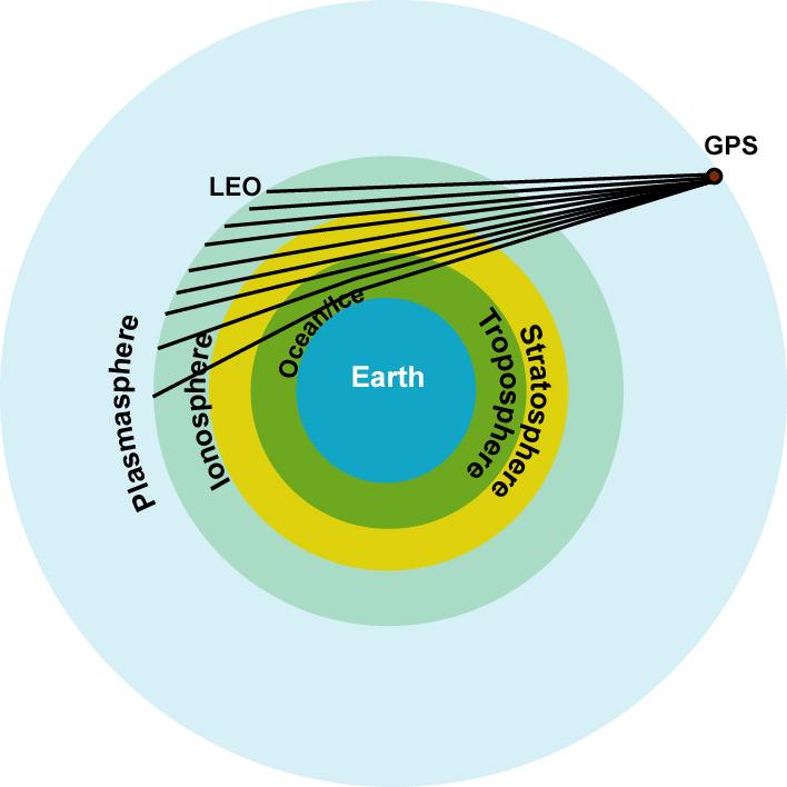
5 Spaceborne GPS Receiver Examples PROBA-1 ESA technology demonstrator SGR-20 quad antenna receiver Still operational after > 11 years Strand kg Cubesat Carrying android mobile phone SGR-05U miniaturised receiver Launched February 2013 GIOVE-A ESA Galileo demonstrator SGR-GEO high altitude GPS receiver Positioning above GPS constellation November

6 Satellite Constellations and Sea State Single high-spec satellites have limited coverage E.g. Topex/Poseidon has 10 day repeat ground track Large gaps: limited value for dynamics and fine scale Satellite constellations give new opportunities High temporal, high spatial coverage feasible Validation of near real-time wind and wave models Long term observations for climate models Ice edge and concentration monitoring Towards operational monitoring service sea state, cyclones, storm surge, tsunamis, etc. To be feasible, need low cost, low power instruments, with adequate accuracy Target is for constellation to cost same as high-spec satellite 6

 First dedicated in-orbit experiment: UK-DMC")
7 GNSS Reflectometry GNSS Reflectometry Detecting GPS / GNSS signals reflected off the Earth s surfaces Signals should contain geophysical imprint Using Earth-reflected GPS signals for ocean sensing first proposed in ESA proposed reflectometry for ocean altimetry PARIS ESA Oppscat study in late 90s 00s - scatterometry First reflected signal detected 1998 (JPL using SIR-C data) First dedicated in-orbit experiment: UK-DMC (2003) 7

8 UK-DMC-1 GPS Reflectometry Experiment Pioneering GPS Reflectometry experiment in orbit Carried on UK-DMC imaging satellite, launched Sept 2003 SSTL & BNSC Newton funding Hardware: GPS Receiver with IF output Data-recorder Medium gain 12 dbi LHCP nadir antenna Each collection 20 seconds of raw data To be processed on ground Imager Reflectometry Antenna First dedicated GNSS reflectometry experiment 8
 And dmss in turn related to wind speed ~60 collections gathered over sea, land and ice Signals collected from all surface")
9 Recovered Signals Processing sampled data reveals reflected signals Correlate data with GPS code & carrier Coherent 1 ms, then incoherent to 1 second Correlation shape related to ocean roughness (dmss) And dmss in turn related to wind speed ~60 collections gathered over sea, land and ice Signals collected from all surface types! 9

10 GNSS Reflectometry over ice January 2008

11 GNSS Land Reflections Nebraska, USA GPS PRN 18 11

12 WaveSentry Project 2012 Industry partnership to collate and exploit wave knowledge TSB (UK Govt) sponsored (50%) Led by HR Wallingford & MSE Data Suppliers: Buoys around UK Ferries / Ship wave instruments SSTL s GNSS-Reflectometry Other satellite wave data Potential Users: Off-shore wind and wave energy suppliers, Off-shore gas and oil, shipping management Scientists SSTL activities Reprocessing UK-DMC data using latest tools Found many more signals in data away from beam centre NOC converting data into dmss results and validating Preparing for launch of ReSI on TechDemoSat-1 12
 However only some")

13 Reprocessing UK-DMC Data Demonstration of open loop capability new signals available from old collections 42+ UK-DMC data acquisitions over ocean, with reflections from 114 PRNs (GPS satellite ID) However only some collocated with buoys, fewer with directional buoys. NOC working with retrieval algorithms Good convergence with mss Mixed results with direction determination Need for more data from future mission for validation! UK-DMC data R47 13


14 New Instrument Development CEOI Project: (UK Govt) 2009 / 2010 SSTL - Project lead, management, SGR-ReSI core development & test SSC - Antenna design and test National Oceanographic Centre (NOC) - Ocean Reflectometry applications & requirements, Inversion models & outreach Bath - Atmospheric applications & requirements Polar Imaging Ltd - Ice sensing Applications 14
15 SGR-ReSI Basic Block Diagram 4 x L1 antennas Dual Frequency antennas RF F/E L1 RF F/E L1 RF F/E L1/L2 RF F/E L1/L2 Program SRAM (1MB TMR) FLASH (16MB) GNSS Receiver Flash-based FPGA with LEON-3 Core interlink M Hz Co-processor SRAM-based FPGA (reprogrammable) Mass Data Storage DDR2 Interfaces: RS422 / LVDS / CAN / USB Power Supply LVDS (Hi rate Data) GNSS receiver core Enhanced GNSS instrument 16-40V 15


16 Delay Doppler Maps On-board Study supported by ESA Partnership with NOC, Southampton End-to-end instrument demonstration DDMs allow reduction of data rate x onboard => Towards continuous data collection 16
 antennas 5-10 watts, 1 kg")

17 SGR-ReSI on TechDemoSat-1 TechDemoSat kg UK Satellite 8 UK Payloads Launch ~ Q ReSI config: Six front-ends Two dual frequency (L1 & L2C) antennas 5-10 watts, 1 kg Primary goals for ReSI Replacement for SGR-10 Ocean roughness sensing through reflectometry Collection of data for models Real-time demonstration Additional strategic goals Nadir Antenna 17
18 18


19 CYGNSS Cyclones from GNSS CYGNSS for the Earth Venture-2 program CYGNSS measures ocean surface winds within tropical storms and hurricanes Aiming for better weather forecasting & assessment of hurricanes Partners include: University of Michigan - lead SWRI, NASA Ames, Surrey Satellite Technology-US LLC (SSTL subsidiary) Science team includes NOC presence Constellation of 8 microsatellites (18 kg) Payload is the SGR-ReSI Sensing GPS L1 signals reflected off seas under cyclones L-Band good choice penetrates clouds, rain in hurricanes Satellites to be operational in 2017 Prof Chris Ruf University of Michigan 19
 on up to 4 antennas Galileo, Glonass, Beidou (TBC) Precise Clock Module option (CSAC) testing planned First flight planned for 2015 Expect to use on all SSTL satellites and")
20 Next Generation Receiver - SGR-Axio Derived from SGR-ReSI design (- minus Data recorder) Drop-in replacement for SGR-10 with extra capabilities Power ~ 4 watts, mass 1 kg Hardware support for: Dual frequency (L1 & L2C/L5) on up to 4 antennas Galileo, Glonass, Beidou (TBC) Precise Clock Module option (CSAC) testing planned First flight planned for 2015 Expect to use on all SSTL satellites and others Can support GNSS reflectometry if customer wants it Aiming to include GNSS Reflectometry on new DMC-class satellite mission kicking off in 2013 more satellites will follow 20
21 Conclusions GPS widely used on spacecraft for position & time LEO and beyond GNSS Reflectometry promising for ocean sensing UK-DMC experiment showed feasibility WaveSentry project has allowed reprocessing of data GNSS-R to be demonstrated on TechDemoSat-1 Launch planned Sept 2013 SGR-ReSI selected for NASA CYGNSS constellation 8 satellites for sensing hurricanes using GNSS-R SGR-ReSI / Axio as payload of opportunity Flying on SSTL s or other missions, low data rate streams Providing services for meteorology, marine users and scientists Broader applications for ice, snow, land sensing GNSS-Reflectometry on every satellite? 21


1483803804 Email: info@sstl.co.uk Web:www.")
22 Changing the economics of space Thank You Presented by: James Nicholas Surrey Satellite Technology Ltd. Commercial in Confidence 22 Tycho House, 20 Stephenson Road, Surrey Research Park, Guildford, Surrey, GU27YE, United Kingdom Tel: +44(0) Fax:+44(0) Web:
ESA Study GNSS Reflectometry Instrument & Algorithms NCEO/CEOI Conference, 19 th Sept 2012
 Changing the economics of space ESA Study GNSS Reflectometry Instrument & Algorithms NCEO/CEOI Conference, 19 th Sept 2012 #01xxxxx Overview GNSS for Remote Sensing Concept and UK-DMC Experiment Scientific
Developments in GNSS Reflectometry from the SGR-ReSI on TDS-1
 Changing the economics of space Developments in GNSS Reflectometry from the SGR-ReSI on TDS-1 Martin Unwin Philip Jales, Jason Tye (SSTL), Brent Abbott SST-US Christine Gommenginger, Giuseppe Foti (NOC)
Recent GNSS Reflectometry Results from the UK TDS-1 Satellite
 CHANGING THE ECONOMICS OF SPACE Recent GNSS Reflectometry Results from the UK TDS-1 Satellite Martin Unwin ICGPSRO2018, Taipei, 18-20 April 2018 SSTL 2018 Ack: SSTL, NOC, ESA, Surrey, CEOI, UKSA, InnovateUK,
Galileo signal reflections used for monitoring waves and weather at sea
 Press Release Monday 26 th November 2007 Galileo signal reflections used for monitoring waves and weather at sea Surrey Satellite Technology Ltd (SSTL) and the University of Surrey have succeeded for the
Microsatellite Ionospheric Network in Orbit
 Changing the economics of space Microsatellite Ionospheric Network in Orbit Dr Stuart Eves Lead Mission Concepts Engineer SSTL s.eves@sstl.co.uk In tribute to Mino Freund 1962-2012 Introduction Objective
Developments in GNSS-Reflectometry from the SGR-ReSI in orbit on TechDemoSat-1
 SSC16-XII-07 Developments in GNSS-Reflectometry from the SGR-ReSI in orbit on TechDemoSat-1 Martin Unwin, Phil Jales, Jason Tye Surrey Satellite Technology Ltd Tycho House, Surrey Research Park Guildford
CYGNSS Mission Update
 International Ocean Vector Wind Science Team Meeting Portland, OR 19-21 May 2015 CYGNSS Mission Update Chris Ruf (1) CYGNSS Principal Investigator Paul Chang (2), Maria Paola Clarizia (1), Scott Gleason
GNSS-Reflectometry for Observation and Monitoring of Earth surface
 GNSS-Reflectometry for Observation and Monitoring of Earth surface Global Navigation meets Geoinformation ESA ESOC Darmstadt, 28-04-2017 Dr. Ing. Domenico Schiavulli INR engineer support at EUMETSAT Outline
A Global System for Detecting Dangerous Seas Using GNSS Bi-static Radar Technology
 A Global System for Detecting Dangerous Seas Using GNSS Bi-static Radar Technology Scott Gleason, Ka Bian, Alex da Silva Curiel Stephen Mackin and Martin Sweeting 20 th AIAA/USU Smallsat Conference, Logan,
Earth Remote Sensing using Surface-Reflected GNSS Signals (Part II)
") Jet Propulsion Laboratory California Institute of Technology National Aeronautics and Space Administration Jet Propulsion Laboratory California Institute of Technology Pasadena, California Earth Remote
Jet Propulsion Laboratory California Institute of Technology National Aeronautics and Space Administration Jet Propulsion Laboratory California Institute of Technology Pasadena, California Earth Remote
New Technologies for Future EO Instrumentation Mick Johnson
 New Technologies for Future EO Instrumentation Mick Johnson Director of CEOI Monitoring the Earth from Space What data do EO satellites provide? Earth Observation science Operational services Weather,
RAPID DEVELOPMENT OF NAVIGATION PAYLOADS FOR GALILEO FULL OPERATIONAL CAPABILITY
 Changing the economics of space RAPID DEVELOPMENT OF NAVIGATION PAYLOADS FOR GALILEO FULL OPERATIONAL CAPABILITY Alex da Silva Curiel Dubai, January 2011 SSTL - the company UK-based satellite manufacturing
GNSS Reflections over Ocean Surfaces
 GNSS Reflections over Ocean Surfaces State of the Art F. Soulat CCT Space Reflectometry December 1st 2010 Page n 1 Outline Concept GNSS-R Signal On-going Activities ( Applications) CLS GNSS-R Studies CCT
GNSS Remo Sensing in ensin a 6U Cubesat
 GNSS Remote Sensing in a 6U Cubesat Andrew Dempster Remote Sensing using GNSS Radio occultation Well established, with existing missions, v useful for input to weather models Reflectometry Experimental,
Changing the economics of space. STRaND-1 & TDS-1. How the UK does Low Cost TechDemo Missions. Shaun Kenyon Mission Concepts, SSTL
 Changing the economics of space STRaND-1 & TDS-1 How the UK does Low Cost TechDemo Missions Shaun Kenyon Mission Concepts, SSTL In the next 15 minutes Introducing STRaND-1 and TDS-1 Comparison of System
GNSS Reflectometry at GFZ
 GNSS Reflectometry at GFZ Achim Helm, Georg Beyerle, Ralf Stosius, Markus Rothacher (GFZ) External Partners and Contributors: Oliver Montenbruck (DLR), Estel Cardellach, Antonio Rius (IEEC), Sergei Yudanov,
The Typhoon Investigation using GNSS-R Interferometric Signals (TIGRIS)
") The Typhoon Investigation using GNSS-R Interferometric Signals (TIGRIS) F. Fabra 1, W. Li 2, M. Martín-Neira 3, S. Oliveras 1, A. Rius 1, W. Yang 2, D. Yang 2 and Estel Cardellach 1 1 Institute of Space
The Typhoon Investigation using GNSS-R Interferometric Signals (TIGRIS) F. Fabra 1, W. Li 2, M. Martín-Neira 3, S. Oliveras 1, A. Rius 1, W. Yang 2, D. Yang 2 and Estel Cardellach 1 1 Institute of Space
GEROS-ISS: GNSS REflectometry, Radio Occultation and Scatterometry onboard the International Space Station
 GEROS-ISS: GNSS REflectometry, Radio Occultation and Scatterometry onboard the International Space Station J. Wickert, O. Andersen, L. Bertino, A. Camps, E. Cardellach, B. Chapron, C. Gommenginger, J.
Outline. GPS RO Overview. COSMIC Overview. COSMIC-2 Overview. Summary 9/29/16
 Bill Schreiner and UCAR/COSMIC Team UCAR COSMIC Program Observation and Analysis Opportunities Collaborating with the ICON and GOLD Missions Sept 27, 216 GPS RO Overview Outline COSMIC Overview COSMIC-2
TechDemoSat-1 & NovaSAR-S
 TechDemoSat-1 & NovaSAR-S Lily Dodemant / Peter Fletcher UKSA Ground Segment Team 6th June 2012 http://www.bis.gov.uk/ukspaceagency TechDemoSat-1 Objectives A technology demonstration satellite project
NASA Earth Science Division Status and Decadal Survey Thoughts Michael H. Freilich
 NASA Earth Science Division Status and Decadal Survey Thoughts Michael H. Freilich March 4, 2014 Earth Science Program Overall Strategy Freilich Maintain a balanced program that: advances Earth System
GNSS remote sensing (GNSS-RS)
") GPS Galileo GLONASS Beidou GNSS remote sensing (GNSS-RS) Shuanggen Jin ( 金双根 ) Shanghai Astronomical Observatory, CAS, Shanghai 200030, China Email: sgjin@shao.ac.cn Website: http://www.shao.ac.cn/geodesy
GPS Galileo GLONASS Beidou GNSS remote sensing (GNSS-RS) Shuanggen Jin ( 金双根 ) Shanghai Astronomical Observatory, CAS, Shanghai 200030, China Email: sgjin@shao.ac.cn Website: http://www.shao.ac.cn/geodesy
A NANOSATELLITE TO DEMONSTRATE GPS OCEANOGRAPHY REFLECTOMETRY
 A NANOSATELLITE TO DEMONSTRATE GPS OCEANOGRAPHY REFLECTOMETRY Maarten Meerman, Dr. Martin Unwin, Scott Gleason, Dr. Susan Jason, Prof. Sir Martin Sweeting Surrey Satellite Technology Limited Surrey Space
CYGNSS Wind Retrieval Performance
 International Ocean Vector Wind Science Team Meeting Kailua-Kona, Hawaii USA 6-8 May 2013 CYGNSS Wind Retrieval Performance Chris Ruf (1), Maria-Paola Clarizia (1,2), Andrew O Brien (3), Joel Johnson (3),
Using COTs components to Reduce Space Mission Costs: Facts, Myths, Advantages & Pitfalls
 Changing the economics of space Using COTs components to Reduce Space Mission Costs: Facts, Myths, Advantages & Pitfalls Andy Bradford Director of Special Programmes, Surrey Satellite Technology Limited
GNSS Reflectometry and Passive Radar at DLR
 ACES and FUTURE GNSS-Based EARTH OBSERVATION and NAVIGATION 26./27. May 2008, TU München Dr. Thomas Börner, Microwaves and Radar Institute, DLR Overview GNSS Reflectometry a joined proposal of DLR and
Development in GNSS Space Receivers
 International Technical Symposium on Navigation and Timing November 16th, 2015 Development in GNSS Space Receivers Lionel RIES - CNES 1 C O GNSS in Space : Use-cases and Challenges Receivers State-of-the-Art
Small Satellites: The Execution and Launch of a GPS Radio Occultation Instrument in a 6U Nanosatellite
 Small Satellites: The Execution and Launch of a GPS Radio Occultation Instrument in a 6U Nanosatellite Dave Williamson Director, Strategic Programs Tyvak Tyvak: Satellite Solutions for Multiple Organizations
Ocean Altimetry and Wind Applications of a GNSS Nanosatellite Constellation
 Ocean Altimetry and Wind Applications of a GNSS Nanosatellite Constellation Randall Rose* a, Christopher S. Ruf b, Haruo Seki c a Southwest Research Institute, 6220 Culebra Rd. San Antonio, Texas, USA
Iridium NEXT SensorPODs: Global Access For Your Scientific Payloads
 Iridium NEXT SensorPODs: Global Access For Your Scientific Payloads 25 th Annual AIAA/USU Conference on Small Satellites August 9th 2011 Dr. Om P. Gupta Iridium Satellite LLC, McLean, VA, USA Iridium 1750
An overview of the COSMIC follow-on mission (COSMIC-II) and its potential for GNSS-R
 and its potential for GNSS-R") An overview of the COSMIC follow-on mission (COSMIC-II) and its potential for GNSS-R Lidia Cucurull (1), Dave Ector (2), and Estel Cardellach (3) (1) NOAA/NWS/NCEP/EMC (2) NOAA/NESDIS/OSD (3) IEEC/ICE-CSIC
An overview of the COSMIC follow-on mission (COSMIC-II) and its potential for GNSS-R Lidia Cucurull (1), Dave Ector (2), and Estel Cardellach (3) (1) NOAA/NWS/NCEP/EMC (2) NOAA/NESDIS/OSD (3) IEEC/ICE-CSIC
MEMS in Space A New Technology Advancing from Flight Experiment to Proven COTS Product
 Changing the economics of space MEMS in Space A New Technology Advancing from Flight Experiment to Proven COTS Product Andrew Carrel (Surrey Satellite Technology) Paul Alderton (Atlantic Inertial Systems)
Space Situational Awareness 2015: GPS Applications in Space
 Space Situational Awareness 2015: GPS Applications in Space James J. Miller, Deputy Director Policy & Strategic Communications Division May 13, 2015 GPS Extends the Reach of NASA Networks to Enable New
New Small Satellite Capabilities for Microwave Atmospheric Remote Sensing: The Earth Observing Nanosatellite- Microwave (EON-MW)
") New Small Satellite Capabilities for Microwave Atmospheric Remote Sensing: The Earth Observing Nanosatellite- Microwave (EON-MW) W. Blackwell, D. Cousins, and L. Fuhrman MIT Lincoln Laboratory August 6,
New Small Satellite Capabilities for Microwave Atmospheric Remote Sensing: The Earth Observing Nanosatellite- Microwave (EON-MW) W. Blackwell, D. Cousins, and L. Fuhrman MIT Lincoln Laboratory August 6,
CYGNSS MISSION OVERVIEW AND PREFLIGHT UPDATE
 CYGNSS MISSION OVERVIEW AND PREFLIGHT UPDATE Randall Rose, John Scherrer, Debra Rose Southwest Research Institute 6220 Culebra, San Antonio TX 78238; 210-522-3315 rrose@swri.org Christopher Ruf University
SPACE APPLICATIONS OF GNSS
 SPACE APPLICATIONS OF GNSS Penina Axelrad Colorado Center for Astrodynamics Research University of Colorado Boulder International Technical Symposium on Navigation and Timing 15-16 Nov 2016 Ecole Nationale
Airborne demonstrators: a small step from space?
 Airborne demonstrators: a small step from space? Mick Johnson Director of CEOI With inputs from: Ray Dunster, Tony Sephton, Martin Cohen (Astrium) Brian Moyna (STFC/RAL) Paul Davey (QinetiQ) Objective
Microwave Radiometers for Small Satellites
 Microwave Radiometers for Small Satellites Gregory Allan, Ayesha Hein, Zachary Lee, Weston Marlow, Kerri Cahoy MIT STAR Laboratory Daniel Cousins, William J. Blackwell MIT Lincoln Laboratory This work
NanoRacks Customer Payloads on Orbital-ATK-9
 NanoRacks Customer Payloads on Orbital-ATK-9 NANORACKS CUBESAT DEPLOYER (INTERNATIONAL SPACE STATION) NASA ELaNa 23, CubeRRT Ohio State University, Columbus, Ohio 6U CubeRRT will be delivered by the Orbital
OBSERVATION PERFORMANCE OF A PARIS ALTIMETER IN-ORBIT DEMONSTRATOR
 OBSERVATION PERFORMANCE OF A PARIS ALTIMETER IN-ORBIT DEMONSTRATOR Salvatore D Addio, Manuel Martin-Neira Acknowledgment to: Nicolas Floury, Roberto Pietro Cerdeira TEC-ETP, ETP, Electrical Engineering
Polar Communications & Weather (PCW) Mission. Guennadi Kroupnik, Canadian Space Agency
 Mission. Guennadi Kroupnik, Canadian Space Agency") Polar Communications & Weather (PCW) Mission Guennadi Kroupnik, Canadian Space Agency Mission Objectives Reliable communications and navigations services in the high latitudes (North of 70º) to ensure:
Polar Communications & Weather (PCW) Mission Guennadi Kroupnik, Canadian Space Agency Mission Objectives Reliable communications and navigations services in the high latitudes (North of 70º) to ensure:
GNSS Remote Sensing: CubeSat case study
 GNSS Remote Sensing: CubeSat case study P-GRESSION system and its background at PoliTo CubeSat Team Lorenzo Feruglio PhD student, Aerospace Engineering LIST OF ACRONYMS LIST OF FIGURES Introduction GNSS
Foreword by Glen Gibbons About this book Acknowledgments List of abbreviations and acronyms List of definitions
 Table of Foreword by Glen Gibbons About this book Acknowledgments List of abbreviations and acronyms List of definitions page xiii xix xx xxi xxv Part I GNSS: orbits, signals, and methods 1 GNSS ground
Five Years Orbit Experience of a Small Satellite Hyperspectral Imaging Mission. Mike Cutter & Martin Sweeting. AIAA Utah, August 2007
 Five Years Orbit Experience of a Small Satellite Hyperspectral Imaging Mission Mike Cutter & Martin Sweeting AIAA Utah, August 2007 SSTL - the company Surrey Satellite Technology Ltd is a private British
SURREY GSA CATALOG. Surrey Satellite Technology US LLC 8310 South Valley Highway, 3rd Floor, Englewood, CO
 SURREY CATALOG Space-Qualified flight hardware for small satellites, including GPS receivers, Attitude Determination and Control equipment, Communications equipment and Remote Sensing imagers Professional
Upstream UK Capabilities. Rob Scott
 Upstream UK Capabilities Rob Scott Platforms LEO, MEO, GEO Cube-, Nano-, Micro-, Small- and Large-sats Deployable in high inclination LEO, or HEO/Molnya if needed High Altitude Platforms (winged and dirigible)
GomSpace Presentation to Hytek Workshop
 GomSpace Presentation to Hytek Workshop Presented by: Lars K. Alminde Managing Director GomSpace Aps alminde@gomspace.com Do not redistribute without permission GomSpace at a Glance University spin-off
Analysis of GNSS-R delay-doppler maps from the UK-DMC satellite over the ocean
 Click Here for Full Article GEOPHYSICAL RESEARCH LETTERS, VOL. 36, L02608, doi:10.1029/2008gl036292, 2009 Analysis of GNSS-R delay-doppler maps from the UK-DMC satellite over the ocean M. P. Clarizia,
NOAA Satellite and Information Service National Environmental Satellite, Data, and Information Service (NESDIS)
") NOAA Satellite and Information Service National Environmental Satellite, Data, and Information Service (NESDIS) Status of Current and Future Systems (NOAA-WP-33) Presentation to CGMS-40 November 2012;
NOAA Satellite and Information Service National Environmental Satellite, Data, and Information Service (NESDIS) Status of Current and Future Systems (NOAA-WP-33) Presentation to CGMS-40 November 2012;
NovaSAR-S - Bringing Radar Capability to the Disaster Monitoring Constellation
 Changing the economics of space NovaSAR-S - Bringing Radar Capability to the Disaster Monitoring Constellation SSTL: Philip Davies, Phil Whittaker, Rachel Bird, Luis Gomes, Ben Stern, Prof Sir Martin Sweeting
Deriving meteorological observations from intercepted Mode-S EHS messages.
 Deriving meteorological observations from intercepted Mode-S EHS messages. Edmund Keith Stone and Malcolm Kitchen July 28, 2016 Abstract The Met Office has deployed a network of five receivers in the UK
Sounding the Atmosphere Ground Support for GNSS Radio-Occultation Processing
 Sounding the Atmosphere Ground Support for GNSS Radio-Occultation Processing Atmospheric Sounding René Zandbergen & John M. Dow Navigation Support Office, Ground Systems Engineering Department, Directorate
Remote Sensing with Reflected Signals
 Remote Sensing with Reflected Signals GNSS-R Data Processing Software and Test Analysis Dongkai Yang, Yanan Zhou, and Yan Wang (airplane) istockphoto.com/mark Evans; gpsiff background Authors from a leading
Innovative Sea Surface Monitoring with GNSS-Reflectometry aboard ISS: Overview and Recent Results from GEROS-ISS
 Innovative Sea Surface Monitoring with GNSS-Reflectometry aboard ISS: Overview and Recent Results from GEROS-ISS J. Wickert, O. Andersen, L. Bertoni, B. Chapron, E. Cardellach, N. Catarinho, C. Gommenginger,
Disruptive technologies and future trends of small satellites
 2016 SSTL Disruptive technologies and future trends of small satellites Luis Gomes Director of EO & science Surrey Satellite Technology Limited Radio Communication June 1978 2016 SSTL The DMC and RapidEye
The signals from the GPS constellation
 INNOVATION Remote Sensing Reflecting on GPS Sensing Land and Ice from Low Earth Orbit Scott T. Gleason GPS IS NOT YOUR PARENTS POSITIONING SYSTEM. Today, GPS is being used in a variety of unconventional
Integration and Test of the Microwave Radiometer Technology Acceleration (MiRaTA) CubeSat
 CubeSat") Integration and Test of the Microwave Radiometer Technology Acceleration (MiRaTA) CubeSat Kerri Cahoy, Gregory Allan, Ayesha Hein, Andrew Kennedy, Zachary Lee, Erin Main, Weston Marlow, Thomas Murphy MIT
Integration and Test of the Microwave Radiometer Technology Acceleration (MiRaTA) CubeSat Kerri Cahoy, Gregory Allan, Ayesha Hein, Andrew Kennedy, Zachary Lee, Erin Main, Weston Marlow, Thomas Murphy MIT
Industry Day of the Copernicus Sentinel-5 and Jason-CS Projects
 Industry Day of the Copernicus Sentinel-5 and Jason-CS Projects With the present announcement, the European Space Agency and Astrium GmbH Satellites (Germany) inform the EMITS Users (European Companies
TN11 - Executive Summary for ESA Contract 21488/08/NL/HE. Prepared by... S Chalkley. Approved by... Technical Director, Aero-Space Division
 CREATING SOLUTIONS THAT WORK Copy No Number Title Classification SEA/08/TN/8155 TN11 - Executive Summary for ESA Contract 21488/08/NL/HE Systems Engineering & Assessment Ltd Beckington Castle PO Box 800
Space Technology Mission Directorate. NASA's Role in Small Spacecraft Technologies: Today and in the Future
 National Aeronautics and Space Administration Space Technology Mission Directorate NASA's Role in Small Spacecraft Technologies: Today and in the Future Presented by: Jim Reuter Deputy Associate Administrator
Relative Navigation, Timing & Data. Communications for CubeSat Clusters. Nestor Voronka, Tyrel Newton
 Relative Navigation, Timing & Data Communications for CubeSat Clusters Nestor Voronka, Tyrel Newton Tethers Unlimited, Inc. 11711 N. Creek Pkwy S., Suite D113 Bothell, WA 98011 425-486-0100x678 voronka@tethers.com
First Results From the GPS Compact Total Electron Content Sensor (CTECS) on the PSSCT-2 Nanosat
 on the PSSCT-2 Nanosat") First Results From the GPS Compact Total Electron Content Sensor (CTECS) on the PSSCT-2 Nanosat Rebecca Bishop 1, David Hinkley 1, Daniel Stoffel 1, David Ping 1, Paul Straus 1, Timothy Burbaker 2 1 The
First Results From the GPS Compact Total Electron Content Sensor (CTECS) on the PSSCT-2 Nanosat Rebecca Bishop 1, David Hinkley 1, Daniel Stoffel 1, David Ping 1, Paul Straus 1, Timothy Burbaker 2 1 The
Microwave Sensors Subgroup (MSSG) Report
 Report") Microwave Sensors Subgroup (MSSG) Report CEOS WGCV-35 May 13-17, 2013, Shanghai, China DONG, Xiaolong, MSSG Chair CAS Key Laboratory of Microwave Remote Sensing National Space Science Center Chinese Academy
Microwave Sensors Subgroup (MSSG) Report CEOS WGCV-35 May 13-17, 2013, Shanghai, China DONG, Xiaolong, MSSG Chair CAS Key Laboratory of Microwave Remote Sensing National Space Science Center Chinese Academy
THE GNSS OCCULTATION, REFLECTOMETRY, AND SCATTEROMETRY SPACE RECEIVER GORS: CURRENT STATUS AND FUTURE PLANS WITHIN GITEWS
 THE GNSS OCCULTATION, REFLECTOMETRY, AND SCATTEROMETRY SPACE RECEIVER GORS: CURRENT STATUS AND FUTURE PLANS WITHIN GITEWS A. Helm (1), G. Beyerle (1), R. Stosius (1), O. Montenbruck (2), S. Yudanov (3),
FIRST SPACEBORNE OBSERVATION OF SEA SURFACE HEIGHT USING GPS-REFLECTOMETRY. University of Michigan, Ann Arbor USA
 FIRST SPACEBORNE OBSERVATION OF SEA SURFACE HEIGHT USING GPS-REFLECTOMETRY Maria Paola Clarizia 1, Christopher Ruf 1, Paolo Cipollini 2 and Cinzia Zuffada 3 1 University of Michigan, Ann Arbor USA 2 National
Ionospheric H-Atom Tomography: a Feasibility Study using GNSS Reflections. G. Ruffini, Josep Marco, L. Ruffini ESTEC, Dec 17th 2002
 Ionospheric H-Atom Tomography: a Feasibility Study using GNSS Reflections. G. Ruffini, Josep Marco, L. Ruffini ESTEC, Dec 17th 2002 Goals of the GIOS-1 study ESTEC Tech Officer: Bertram Arbesser-Rastburg
Microwave Sensors Subgroup (MSSG) Report
 Report") Microwave Sensors Subgroup (MSSG) Report Feb 17-20, 2014, ESA ESRIN, Frascati, Italy DONG, Xiaolong, MSSG Chair National Space Science Center Chinese Academy of Sciences (MiRS,NSSC,CAS) Email: dongxiaolong@mirslab.cn
Microwave Sensors Subgroup (MSSG) Report Feb 17-20, 2014, ESA ESRIN, Frascati, Italy DONG, Xiaolong, MSSG Chair National Space Science Center Chinese Academy of Sciences (MiRS,NSSC,CAS) Email: dongxiaolong@mirslab.cn
NOAA Satellite Observing System Architecture (NSOSA) Study Update
 Study Update") NOAA Satellite Observing System Architecture (NSOSA) Study Update Dr. Karen St. Germain Director NOAA/NESDIS Office of System Architecture and Advanced Planning (OSAAP) Spring 2017 Meeting of the Committee
NOAA Satellite Observing System Architecture (NSOSA) Study Update Dr. Karen St. Germain Director NOAA/NESDIS Office of System Architecture and Advanced Planning (OSAAP) Spring 2017 Meeting of the Committee
SATELLITE OCEANOGRAPHY
 SATELLITE OCEANOGRAPHY An Introduction for Oceanographers and Remote-sensing Scientists I. S. Robinson Lecturer in Physical Oceanography Department of Oceanography University of Southampton JOHN WILEY
2 INTRODUCTION TO GNSS REFLECTOMERY
 2 INTRODUCTION TO GNSS REFLECTOMERY 2.1 Introduction The use of Global Navigation Satellite Systems (GNSS) signals reflected by the sea surface for altimetry applications was first suggested by Martín-Neira
GNSS Reflectometry: Innovative Remote Sensing
 GNSS Reflectometry: Innovative Remote Sensing J. Beckheinrich 1, G. Beyerle 1, S. Schön 2, H. Apel 1, M. Semmling 1, J. Wickert 1 1.GFZ, German Research Center for Geosciences, Potsdam, Germany 2.Leibniz
Spaceborne Receiver Design for Scatterometric GNSS Reflectometry
 Spaceborne Receiver Design for Scatterometric GNSS Reflectometry Philip Jales Submitted for the Degree of Doctor of Philosophy from the University of Surrey Surrey Space Centre Faculty of Engineering and
Arctic Navigation Issues. e-nav conference Nordic Institute of Navigation Bergen, March 5 th 2009
 Arctic Navigation Issues e-nav conference Nordic Institute of Navigation Bergen, March 5 th 2009 by Anna B.O. Jensen - AJ Geomatics Jean-Paul Sicard - Rovsing A/S March 2009 1 Outline Reduction of ice
Non-PNT Applications from GNSS. Dr. Yang Dongkai School of Electronics and Information BeiHang University
 Non-PNT Applications from GNSS Dr. Yang Dongkai edkyang@buaa.edu.cn School of Electronics and Information BeiHang University Outline 1 2 3 Introduction Typical Non-PNT Applications Potential Cooperation
CubeSat Navigation System and Software Design. Submitted for CIS-4722 Senior Project II Vermont Technical College Al Corkery
 CubeSat Navigation System and Software Design Submitted for CIS-4722 Senior Project II Vermont Technical College Al Corkery Project Objectives Research the technical aspects of integrating the CubeSat
CubeSat Integration into the Space Situational Awareness Architecture
 CubeSat Integration into the Space Situational Awareness Architecture Keith Morris, Chris Rice, Mark Wolfson Lockheed Martin Space Systems Company 12257 S. Wadsworth Blvd. Mailstop S6040 Littleton, CO
GNSS-R for Ocean and Cryosphere Applications
 GNSS-R for Ocean and Cryosphere Applications E.Cardellach and A. Rius Institut de Ciències de l'espai (ICE/IEEC-CSIC), Spain Contents Altimetry with Global Navigation Satellite Systems: Model correlation
BeiDou Space Service Volume Parameters and its Performance
 BeiDou Space Service Volume Parameters and its Performance Prof. Xingqun ZHAN, Shuai JING Shanghai Jiaotong University, China Xiaoliang WANG China Academy of Space Technology Contents 1 Background and
The Global Imager (GLI)
") The Global Imager (GLI) Launch : Dec.14, 2002 Initial check out : to Apr.14, 2003 (~L+4) First image: Jan.25, 2003 Second image: Feb.6 and 7, 2003 Calibration and validation : to Dec.14, 2003(~L+4) for
The Global Imager (GLI) Launch : Dec.14, 2002 Initial check out : to Apr.14, 2003 (~L+4) First image: Jan.25, 2003 Second image: Feb.6 and 7, 2003 Calibration and validation : to Dec.14, 2003(~L+4) for
Microwave Remote Sensing
 Provide copy on a CD of the UCAR multi-media tutorial to all in class. Assign Ch-7 and Ch-9 (for two weeks) as reading material for this class. HW#4 (Due in two weeks) Problems 1,2,3 and 4 (Chapter 7)
Aeolus Campaign Planning
 Aeolus Campaign Planning Dirk Schuettemeyer, Anne-Grete Straume, Thomas Kanitz, Alexander Geiss, Jonas v. Bismarck ESA UNCLASSIFIED - For Official Use Programmatic Background ESA campaign activities started
Active microwave systems (2) Satellite Altimetry * range data processing * applications
 Satellite Altimetry * range data processing * applications") Remote Sensing: John Wilkin wilkin@marine.rutgers.edu IMCS Building Room 211C 732-932-6555 ext 251 Active microwave systems (2) Satellite Altimetry * range data processing * applications Satellite Altimeters
Remote Sensing: John Wilkin wilkin@marine.rutgers.edu IMCS Building Room 211C 732-932-6555 ext 251 Active microwave systems (2) Satellite Altimetry * range data processing * applications Satellite Altimeters
Remote Sensing using Bistatic GPS and a Digital Beam Steering Receiver
 Remote Sensing using Bistatic GPS and a Digital Beam Steering Receiver Alison Brown and Ben Mathews, NAVSYS Corporation BIOGRAPHY Alison Brown is the President and Chief Executive Officer of NAVSYS Corporation.
Precise Positioning with Smartphones running Android 7 or later
 Precise Positioning with Smartphones running Android 7 or later * René Warnant, * Cécile Deprez, + Quentin Warnant * University of Liege Geodesy and GNSS + Augmenteo, Plaine Image, Lille (France) Belgian
Worst-Case GPS Constellation for Testing Navigation at Geosynchronous Orbit for GOES-R
 Worst-Case GPS Constellation for Testing Navigation at Geosynchronous Orbit for GOES-R Kristin Larson, Dave Gaylor, and Stephen Winkler Emergent Space Technologies and Lockheed Martin Space Systems 36
Integrity of Satellite Navigation in the Arctic
 Integrity of Satellite Navigation in the Arctic TODD WALTER & TYLER REID STANFORD UNIVERSITY APRIL 2018 Satellite Based Augmentation Systems (SBAS) in 2018 2 SBAS Networks in 2021? 3 What is Meant by Integrity?
PicoSaTs. A. G r e g o r i o D e p a r t m e n t o f P h y s i c s. Spin-off University of Trieste - Incubation Area Science Park
 D o i n g S c i e n c e w i t h N a n o - s a t e l l i t e s PicoSaTs A. G r e g o r i o D e p a r t m e n t o f P h y s i c s Professor GIORGIO MANZONI *1939-2012 Spin-off University of Trieste - Incubation
RAX: Lessons Learned in Our Spaceflight Endeavor
 RAX: Lessons Learned in Our Spaceflight Endeavor Matt Bennett University of Michigan CubeSat Workshop Cal Poly, San Luis Obispo April 21 st, 2010 Background Sponsored by National Science Foundation University
Sysnova Weather Challenge Response: Executive Summary
 P R O J E C T SysNova Nanosatellite Weather Challenge Response: Executive Summary W O R K P A C K A G E N U M B E R SS F A S S T L R E F E R E N C E 0253897 C U S T O M E R I D N U M B E R R E V I S I
SEA SURFACE TEMPERATURE RETRIEVAL USING TRMM MICROWAVE IMAGER DATA IN SOUTH CHINA SEA
 SEA SURFACE TEMPERATURE RETRIEVAL USING TRMM MICROWAVE IMAGER DATA IN SOUTH CHINA SEA Mohd Ibrahim Seeni Mohd and Mohd Nadzri Md. Reba Faculty of Geoinformation Science and Engineering Universiti Teknologi
RemoveDebris Mission: Briefing to UNCOPUOS
 Changing the economics of space RemoveDebris Mission: Briefing to UNCOPUOS 9 th Feb 2015 Chris Saunders Surrey Satellite Technology Limited Guildford, United Kingdom RemoveDebris Mission RemoveDebris is
Copernicus Introduction Lisbon, Portugal 13 th & 14 th February 2014
 Copernicus Introduction Lisbon, Portugal 13 th & 14 th February 2014 Contents Introduction GMES Copernicus Six thematic areas Infrastructure Space data An introduction to Remote Sensing In-situ data Applications
Rapid Development and Test for UKube-1 using Software and Hardware-in-the-Loop Simulation. Peter Mendham and Mark McCrum
 Rapid Development and Test for UKube-1 using Software and Hardware-in-the-Loop Simulation Peter Mendham and Mark McCrum UKube-1 United Kingdom Universal Bus Experiment 3U CubeSat Five payloads C3D imager
8th Int l Precip. Working Group & 5th Int l Workshop on Space-based Snow Measurement, Bologna, Italia
 8th Int l Precip. Working Group & 5th Int l Workshop on Space-based Snow Measurement, Bologna, Italia Time-Resolved Measurements of Precipitation from 6U-Class Satellite Constellations: Temporal Experiment
Soil Moisture Observation Utilizing Reflected GNSS Signals
 Soil Moisture Observation Utilizing Reflected GNSS Signals GNSS-R Tech in Soil Moisture New Data Processing Method Prof. Dongkai YANG Joint African/Asia-Pacific UN-Regional Centers and International Training
Dimov Stojče Ilčev. CNS Systems
 Stratospheric Platform Systems (SPS) Presentation by: Dimov Stojče Ilčev Durban University of Technology (DUT) Space Science Centre (SSC) CNS Systems August 2011 SPS for Mobile CNS Applications Stratospheric
AIREON SPACE-BASED ADS-B
 AIREON SPACE-BASED ADS-B 2018 Transport Canada Delegates Conference Steve Bellingham Manager, Navigation Systems Engineering Steve.Bellingham@navcanada.ca CNS/ATM Systems Communication Navigation Surveillance
China. France Oceanography S A T. Overview of the near-real time wave products of the CFOSAT mission. e l l i t e
 China Overview of the near-real time wave products of the CFOSAT mission C. Tison (1), D. Hauser (2), S. Guibert (1), T. Amiot (1), L. Aouf (3), J.M. Lefèvre (3), B. Chapron (5), N. Corcoral (1), P. Castillan
The Future of GNSS-RO for Global Weather Monitoring and Prediction A COSMIC-2 / FORMOSAT-7 Program Status Update
 The Future of GNSS-RO for Global Weather Monitoring and Prediction A COSMIC-2 / FORMOSAT-7 Program Status Update Kendra Cook Lead NOAA Systems Engineer C 2 International, LLC 2 October 2014 Co-Authors:
SSTL Contribution to NDU Spacepower Symposium. Dr. Stuart Eves 26 April 2007
 SSTL Contribution to NDU Spacepower Symposium Dr. Stuart Eves s.eves@sstl.co.uk 26 April 2007 Report Documentation Page Form Approved OMB No. 0704-0188 Public reporting burden for the collection of information