GNSS-Reflectometry for Observation and Monitoring of Earth surface
|
|
|
- Mervin Haynes
- 6 years ago
- Views:
Transcription

1 GNSS-Reflectometry for Observation and Monitoring of Earth surface Global Navigation meets Geoinformation ESA ESOC Darmstadt, Dr. Ing. Domenico Schiavulli INR engineer support at EUMETSAT
2 Outline Introduction GNSS-R concept A powerful tool for Remote Sensing Summary and Conclusions
3 Introduction Outline


4 Introduction GNSS are worldwide satellite constellations continuously transmitting L band signals, i.e. all weather night-and-day signals. GPS 24 satellites Galileo 30 satellites Beidou 35 satellites Glonass 24 satellites
5 Introduction GNSS are designed to provide Positioning, Velocity and Timing (PVT) to an user with a receiver.
 to an user with a receiver.")

6 Introduction GNSS are designed to provide Positioning, Velocity and Timing (PVT) to an user with a receiver. Navigation services are provided by analyzing the direct signal, while signals reflected off surfaces or obstacles, i.e. multipath, are filtered out Direct signal Multipath
7 GNSS-R concept Outline
8 GNSS-R concept GNSS-Reflectometry exploits GNSS signals reflected off Earth s surface to infer geophysical information of the scattering area

9 GNSS-R concept GNSS-Reflectometry exploits GNSS signals reflected off Earth s surface to infer geophysical information of the scattering area BISTATIC/MULTISTATIC RADAR SYSTEM

10 GNSS-R concept GNSS-R geometry is defined as: SP - Specular Point (SP): the shortest path TX-scattering scene-rx; - Iso-Delay ellipses: points whose scattered signals experience the same delay; - Iso-Doppler hyperbolae: points whose scattered signals experience the same frequency shift.
11 GNSS-R concept The GNSS-R measurement are mapped in the Delay-Doppler Map (DDM) or 1-D Delay waveform
12 Doppler GNSS-R concept The GNSS-R measurement are mapped in the Delay-Doppler Map (DDM) or 1-D Delay waveform Delay SP
13 Doppler GNSS-R concept The GNSS-R measurement are mapped in the Delay-Doppler Map (DDM) or 1-D Delay waveform Delay SP SP Delay

14 GNSS-R concept SAR, ALTIMETER, SCATTEROMETER Service and Product

15 GNSS-R concept GNSS-R main advantages with respect dedicated sensors: - Excellent spatial and temporal coverage; - GNSS long term mission; - Cost effectiveness


16 GNSS-R concept The importance of this promising and innovative technique is confirmed by dedicated space missions: US NASA CYGNSS constellation UK TechDemoSat-1 ESA GEROS-ISS
17 Outline A powerful tool for Imaging Remote Sensing
18 Doppler A powerful tool for Imaging Remote Sensing GNSS-R measurements: Delay Delay
19 Doppler A powerful tool for Imaging Remote Sensing GNSS-R measurements: Delay Delay SPATIAL INFORMATION ON THE OBSERVED SCENE IS LOST
")
20 Doppler A powerful tool for Imaging Remote Sensing GNSS-R measurements: Delay SPATIAL INFORMATION ON THE OBSERVED SCENE IS LOST Delay TEHCNIQUES ARE NEEDED TO TRANSFORM: (Δτ,Δf) (x,y)
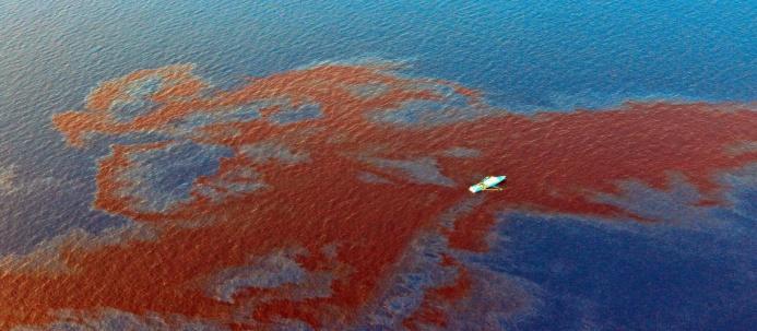
21 Outline A powerful tool for Imaging Remote Sensing Oil spill in simulated environment


22 A powerful tool for Imaging Remote Sensing Cosmo SkyMed SAR image Simulated marine scenario including oill spill
23 A powerful tool for Imaging Remote Sensing Simulated scenario Noisy DDM


24 A powerful tool for Imaging Remote Sensing Processing time = 10s Inverse Problem TSVD applied Simulated scenario Noisy DDM Reconstructed scenario
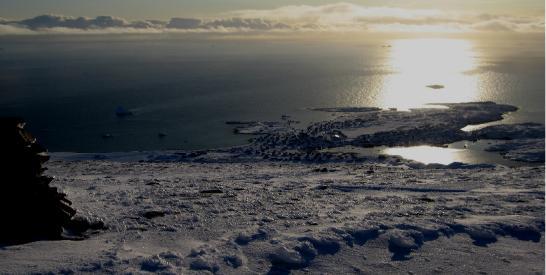
25 Outline A powerful tool for Imaging Remote Sensing Sea/Ice transition detection using TechDemoSat-1 data

26 A powerful tool for Imaging Remote Sensing Track ID: TD Start acquisition time: :20:53 Signal type: GPS L1 End acquisition time: :00:50 PRN: 31

27 A powerful tool for Imaging Remote Sensing SP Acquisition time: :40:53 SP position: 44.7 S, 10.8 W Land type: waterbodies


28 A powerful tool for Imaging Remote Sensing Open ocean DDM Ice DDM


29 A powerful tool for Imaging Remote Sensing Measured DDM Sea ice concentration -Green line is the satellite ground track - Red square is the observed area


30 A powerful tool for Imaging Remote Sensing SSM-I sea ice concentration Reconstructed radar image

31 A powerful tool for Imaging Remote Sensing

32 A powerful tool for Imaging Remote Sensing Sentinel-1 HH SAR image Reconstructed radar image

33 A powerful tool for Imaging Remote Sensing
34 Outline Summary and Conclusions
35 Summary and Conclusions The FORCE of proposed approach: - Added value products to improve/complement dedicated sensors provided they are -A new typo of service and product can be offered to the community - Applications such as target detection, sea/ice transition, etc.. can strongly benefit from these innovative products


36 Summary and Conclusions The FORCE of proposed approach: - Added value products to improve/complement dedicated sensors provided they are -A new typo of service and product can be offered to the community - Applications such as target detection, sea/ice transition, etc.. can strongly benefit from these innovative products The DARK SIDE of the FORCE: The resolution is still coarse. The receiver time coverage is still coarse Both problems can be overcome by using the future constellations of receiver, e.g. CYGNSS or CubeSAT.

37 THANK YOU
Preparation for Flight of Next Generation Space GNSS Receivers
 Changing the economics of space Preparation for Flight of Next Generation Space GNSS Receivers ICGPSRO, 14-16 th May 2013 Taiwan #0205691 Commercial in Confidence 1 Overview SSTL and Spaceborne GNSS Small
A Global System for Detecting Dangerous Seas Using GNSS Bi-static Radar Technology
 A Global System for Detecting Dangerous Seas Using GNSS Bi-static Radar Technology Scott Gleason, Ka Bian, Alex da Silva Curiel Stephen Mackin and Martin Sweeting 20 th AIAA/USU Smallsat Conference, Logan,
Earth Remote Sensing using Surface-Reflected GNSS Signals (Part II)
") Jet Propulsion Laboratory California Institute of Technology National Aeronautics and Space Administration Jet Propulsion Laboratory California Institute of Technology Pasadena, California Earth Remote
Jet Propulsion Laboratory California Institute of Technology National Aeronautics and Space Administration Jet Propulsion Laboratory California Institute of Technology Pasadena, California Earth Remote
2 INTRODUCTION TO GNSS REFLECTOMERY
 2 INTRODUCTION TO GNSS REFLECTOMERY 2.1 Introduction The use of Global Navigation Satellite Systems (GNSS) signals reflected by the sea surface for altimetry applications was first suggested by Martín-Neira
Developments in GNSS Reflectometry from the SGR-ReSI on TDS-1
 Changing the economics of space Developments in GNSS Reflectometry from the SGR-ReSI on TDS-1 Martin Unwin Philip Jales, Jason Tye (SSTL), Brent Abbott SST-US Christine Gommenginger, Giuseppe Foti (NOC)
Galileo signal reflections used for monitoring waves and weather at sea
 Press Release Monday 26 th November 2007 Galileo signal reflections used for monitoring waves and weather at sea Surrey Satellite Technology Ltd (SSTL) and the University of Surrey have succeeded for the
ESA Study GNSS Reflectometry Instrument & Algorithms NCEO/CEOI Conference, 19 th Sept 2012
 Changing the economics of space ESA Study GNSS Reflectometry Instrument & Algorithms NCEO/CEOI Conference, 19 th Sept 2012 #01xxxxx Overview GNSS for Remote Sensing Concept and UK-DMC Experiment Scientific
New Technologies for Future EO Instrumentation Mick Johnson
 New Technologies for Future EO Instrumentation Mick Johnson Director of CEOI Monitoring the Earth from Space What data do EO satellites provide? Earth Observation science Operational services Weather,
Recent GNSS Reflectometry Results from the UK TDS-1 Satellite
 CHANGING THE ECONOMICS OF SPACE Recent GNSS Reflectometry Results from the UK TDS-1 Satellite Martin Unwin ICGPSRO2018, Taipei, 18-20 April 2018 SSTL 2018 Ack: SSTL, NOC, ESA, Surrey, CEOI, UKSA, InnovateUK,
Co-ReSyF RA lecture: Vessel detection and oil spill detection
 This project has received funding from the European Union s Horizon 2020 Research and Innovation Programme under grant agreement no 687289 Co-ReSyF RA lecture: Vessel detection and oil spill detection
GNSS Remote Sensing: CubeSat case study
 GNSS Remote Sensing: CubeSat case study P-GRESSION system and its background at PoliTo CubeSat Team Lorenzo Feruglio PhD student, Aerospace Engineering LIST OF ACRONYMS LIST OF FIGURES Introduction GNSS
2010 International Ocean Vector Winds Meeting Barcelona, Spain, May A NASA Perspective: Present Status and Moving Forward
 2010 International Ocean Vector Winds Meeting Barcelona, Spain, 18-20 May 2010 A NASA Perspective: Present Status and Moving Forward Peter Hacker and Eric Lindstrom NASA Science Mission Directorate Earth
The Typhoon Investigation using GNSS-R Interferometric Signals (TIGRIS)
") The Typhoon Investigation using GNSS-R Interferometric Signals (TIGRIS) F. Fabra 1, W. Li 2, M. Martín-Neira 3, S. Oliveras 1, A. Rius 1, W. Yang 2, D. Yang 2 and Estel Cardellach 1 1 Institute of Space
The Typhoon Investigation using GNSS-R Interferometric Signals (TIGRIS) F. Fabra 1, W. Li 2, M. Martín-Neira 3, S. Oliveras 1, A. Rius 1, W. Yang 2, D. Yang 2 and Estel Cardellach 1 1 Institute of Space
CYGNSS Wind Retrieval Performance
 International Ocean Vector Wind Science Team Meeting Kailua-Kona, Hawaii USA 6-8 May 2013 CYGNSS Wind Retrieval Performance Chris Ruf (1), Maria-Paola Clarizia (1,2), Andrew O Brien (3), Joel Johnson (3),
KONGSBERG SATELLITE SERVICES Earth Observation for Maritime Operations Current Capabilities and Future Potential
 KONGSBERG SATELLITE SERVICES 2017 Earth Observation for Maritime Operations Current Capabilities and Future Potential Andreas Hay Kaljord Project Manager KSAT HQ IN TROMSØ - 69N WELCOME TO TROMSØ Established
Developments in GNSS-Reflectometry from the SGR-ReSI in orbit on TechDemoSat-1
 SSC16-XII-07 Developments in GNSS-Reflectometry from the SGR-ReSI in orbit on TechDemoSat-1 Martin Unwin, Phil Jales, Jason Tye Surrey Satellite Technology Ltd Tycho House, Surrey Research Park Guildford
GEROS-ISS: GNSS REflectometry, Radio Occultation and Scatterometry onboard the International Space Station
 GEROS-ISS: GNSS REflectometry, Radio Occultation and Scatterometry onboard the International Space Station J. Wickert, O. Andersen, L. Bertino, A. Camps, E. Cardellach, B. Chapron, C. Gommenginger, J.
MULTI-CHANNEL SAR EXPERIMENTS FROM THE SPACE AND FROM GROUND: POTENTIAL EVOLUTION OF PRESENT GENERATION SPACEBORNE SAR
 3 nd International Workshop on Science and Applications of SAR Polarimetry and Polarimetric Interferometry POLinSAR 2007 January 25, 2007 ESA/ESRIN Frascati, Italy MULTI-CHANNEL SAR EXPERIMENTS FROM THE
EE 529 Remote Sensing Techniques. Introduction
 EE 529 Remote Sensing Techniques Introduction Course Contents Radar Imaging Sensors Imaging Sensors Imaging Algorithms Imaging Algorithms Course Contents (Cont( Cont d) Simulated Raw Data y r Processing
KONGSBERG SATELLITE SERVICES 2017 Line Steinbakk, Director Programs. Himmel og hav - Ålesund 3. Oktober 2017
 KONGSBERG SATELLITE SERVICES 2017 Line Steinbakk, Director Programs Himmel og hav - Ålesund 3. Oktober 2017 KSAT HQ IN TROMSØ 69N Established in 1967 Kongsberg Satellite Services since 2002 World leading
GNSS Reflectometry: Innovative Remote Sensing
 GNSS Reflectometry: Innovative Remote Sensing J. Beckheinrich 1, G. Beyerle 1, S. Schön 2, H. Apel 1, M. Semmling 1, J. Wickert 1 1.GFZ, German Research Center for Geosciences, Potsdam, Germany 2.Leibniz
3D Multi-static SAR System for Terrain Imaging Based on Indirect GPS Signals
 Journal of Global Positioning Systems (00) Vol. 1, No. 1: 34-39 3D Multi-static SA System for errain Imaging Based on Indirect GPS Signals Yonghong Li, Chris izos School of Surveying and Spatial Information
Synthetic Aperture Radar for Rapid Flood Extent Mapping
 National Aeronautics and Space Administration ARSET Applied Remote Sensing Training http://arset.gsfc.nasa.gov @NASAARSET Synthetic Aperture Radar for Rapid Flood Extent Mapping Sang-Ho Yun ARIA Team Jet
GNSS Remo Sensing in ensin a 6U Cubesat
 GNSS Remote Sensing in a 6U Cubesat Andrew Dempster Remote Sensing using GNSS Radio occultation Well established, with existing missions, v useful for input to weather models Reflectometry Experimental,
Understanding GPS: Principles and Applications Second Edition
 Understanding GPS: Principles and Applications Second Edition Elliott Kaplan and Christopher Hegarty ISBN 1-58053-894-0 Approx. 680 pages Navtech Part #1024 This thoroughly updated second edition of an
Space Situational Awareness 2015: GPS Applications in Space
 Space Situational Awareness 2015: GPS Applications in Space James J. Miller, Deputy Director Policy & Strategic Communications Division May 13, 2015 GPS Extends the Reach of NASA Networks to Enable New
Arctic Navigation Issues. e-nav conference Nordic Institute of Navigation Bergen, March 5 th 2009
 Arctic Navigation Issues e-nav conference Nordic Institute of Navigation Bergen, March 5 th 2009 by Anna B.O. Jensen - AJ Geomatics Jean-Paul Sicard - Rovsing A/S March 2009 1 Outline Reduction of ice
KONGSBERG. WORLD CLASS through people, technology and dedication WORLD CLASS through people, technology and dedication
 WORLD CLASS through people, technology and dedication WORLD CLASS through people, technology and dedication Skipsdeteksjon fra radarsatellitter SkipSat Richard Hallr Kongsberg Satellite Services AS (KSAT)
Soil Moisture Observation Utilizing Reflected GNSS Signals
 Soil Moisture Observation Utilizing Reflected GNSS Signals GNSS-R Tech in Soil Moisture New Data Processing Method Prof. Dongkai YANG Joint African/Asia-Pacific UN-Regional Centers and International Training
GLOBAL POSITIONING SYSTEMS
 GLOBAL POSITIONING SYSTEMS GPS & GIS Fall 2017 Global Positioning Systems GPS is a general term for the navigation system consisting of 24-32 satellites orbiting the Earth, broadcasting data that allows
Prototype Software-based Receiver for Remote Sensing using Reflected GPS Signals. Dinesh Manandhar The University of Tokyo
 Prototype Software-based Receiver for Remote Sensing using Reflected GPS Signals Dinesh Manandhar The University of Tokyo dinesh@qzss.org 1 Contents Background Remote Sensing Capability System Architecture
Target Detection Using GPS Signals of Opportunity
 18th International Conference on Information Fusion Washington, DC - July 6-9, 2015 Target Detection Using GPS Signals of Opportunity Maria-Paola Clarizia Atmospheric, Oceanic and Space Sciences University
Use of Synthetic Aperture Radar images for Crisis Response and Management
 2012 IEEE Global Humanitarian Technology Conference Use of Synthetic Aperture Radar images for Crisis Response and Management Gerardo Di Martino, Antonio Iodice, Daniele Riccio, Giuseppe Ruello Department
The last 25 years - GPS to multi-gnss: from a military tool to the most widely used civilian positioning solution
 1 The last 25 years - GPS to multi-gnss: from a military tool to the most widely used civilian positioning solution B. Hofmann-Wellenhof Institute of Geodesy / Navigation, Graz University of Technology
New Signal Structures for BeiDou Navigation Satellite System
 Stanford's 2014 PNT Symposium New Signal Structures for BeiDou Navigation Satellite System Mingquan Lu, Zheng Yao Tsinghua University 10/29/2014 1 Outline 1 Background and Motivation 2 Requirements and
GNSS-R for Ocean and Cryosphere Applications
 GNSS-R for Ocean and Cryosphere Applications E.Cardellach and A. Rius Institut de Ciències de l'espai (ICE/IEEC-CSIC), Spain Contents Altimetry with Global Navigation Satellite Systems: Model correlation
ACTIVE SENSORS RADAR
 ACTIVE SENSORS RADAR RADAR LiDAR: Light Detection And Ranging RADAR: RAdio Detection And Ranging SONAR: SOund Navigation And Ranging Used to image the ocean floor (produce bathymetic maps) and detect objects
Radar remote sensing from space for monitoring deformations affecting urban areas and infrastructures
 Radar remote sensing from space for monitoring deformations affecting urban areas and infrastructures Riccardo Lanari IREA-CNR Napoli EGU2014, Vienna 30 April, 2014 Why Radar (SAR) Imaging from space?
Satellite data for Maritime Operations. Andreas Hay Kaljord Project Manager Energy, Environment & Security
 Satellite data for Maritime Operations Andreas Hay Kaljord Project Manager Energy, Environment & Security Kongsberg Satellite Services (KSAT) World leading provider within our business area Supports 85
Analysis of GNSS-R delay-doppler maps from the UK-DMC satellite over the ocean
 Click Here for Full Article GEOPHYSICAL RESEARCH LETTERS, VOL. 36, L02608, doi:10.1029/2008gl036292, 2009 Analysis of GNSS-R delay-doppler maps from the UK-DMC satellite over the ocean M. P. Clarizia,
GNSS Reflections over Ocean Surfaces
 GNSS Reflections over Ocean Surfaces State of the Art F. Soulat CCT Space Reflectometry December 1st 2010 Page n 1 Outline Concept GNSS-R Signal On-going Activities ( Applications) CLS GNSS-R Studies CCT
Theoretical Simulations of GNSS Reflections from Bare and Vegetated Soils
 Theoretical Simulations of GNSS Reflections from Bare and Vegetated Soils R. Giusto 1, L. Guerriero, S. Paloscia 3, N. Pierdicca 1, A. Egido 4, N. Floury 5 1 DIET - Sapienza Univ. of Rome, Rome DISP -
CYGNSS Mission Update
 International Ocean Vector Wind Science Team Meeting Portland, OR 19-21 May 2015 CYGNSS Mission Update Chris Ruf (1) CYGNSS Principal Investigator Paul Chang (2), Maria Paola Clarizia (1), Scott Gleason
SAOCOM-CS Mission and ESA Airborne Campaign Data
 SAOCOM-CS Mission and ESA Airborne Campaign Data Malcolm Davidson Head of the EOP Campaign Section Malcolm.Davidson@esa.int Objectives of presentation Introduce a new type of ESA SAR mission with Polarimetrice,
Sounding the Atmosphere Ground Support for GNSS Radio-Occultation Processing
 Sounding the Atmosphere Ground Support for GNSS Radio-Occultation Processing Atmospheric Sounding René Zandbergen & John M. Dow Navigation Support Office, Ground Systems Engineering Department, Directorate
Microwave Sensors Subgroup (MSSG) Report
 Report") Microwave Sensors Subgroup (MSSG) Report CEOS WGCV-35 May 13-17, 2013, Shanghai, China DONG, Xiaolong, MSSG Chair CAS Key Laboratory of Microwave Remote Sensing National Space Science Center Chinese Academy
Microwave Sensors Subgroup (MSSG) Report CEOS WGCV-35 May 13-17, 2013, Shanghai, China DONG, Xiaolong, MSSG Chair CAS Key Laboratory of Microwave Remote Sensing National Space Science Center Chinese Academy
King AbdulAziz University. Faculty of Environmental Design. Geomatics Department. Mobile GIS GEOM 427. Lecture 3
 King AbdulAziz University Faculty of Environmental Design Geomatics Department Mobile GIS GEOM 427 Lecture 3 Ahmed Baik, Ph.D. Email: abaik@kau.edu.sa Eng. Fisal Basheeh Email: fbasaheeh@kau.edu.sa GNSS
Challenges and Solutions for GPS Receiver Test
 Challenges and Solutions for GPS Receiver Test Presenter: Mirin Lew January 28, 2010 Agenda GPS technology concepts GPS and GNSS overview Assisted GPS (A-GPS) Basic tests required for GPS receiver verification
Microwave Remote Sensing
 Provide copy on a CD of the UCAR multi-media tutorial to all in class. Assign Ch-7 and Ch-9 (for two weeks) as reading material for this class. HW#4 (Due in two weeks) Problems 1,2,3 and 4 (Chapter 7)
GNSS Ocean Reflected Signals
 GNSS Ocean Reflected Signals Per Høeg DTU Space Technical University of Denmark Content Experimental setup Instrument Measurements and observations Spectral characteristics, analysis and retrieval method
GNSS remote sensing (GNSS-RS)
") GPS Galileo GLONASS Beidou GNSS remote sensing (GNSS-RS) Shuanggen Jin ( 金双根 ) Shanghai Astronomical Observatory, CAS, Shanghai 200030, China Email: sgjin@shao.ac.cn Website: http://www.shao.ac.cn/geodesy
GPS Galileo GLONASS Beidou GNSS remote sensing (GNSS-RS) Shuanggen Jin ( 金双根 ) Shanghai Astronomical Observatory, CAS, Shanghai 200030, China Email: sgjin@shao.ac.cn Website: http://www.shao.ac.cn/geodesy
Research Article GNSS-R Delay-Doppler Map Simulation Based on the 2004 Sumatra-Andaman Tsunami Event
 Journal of Sensors Volume 6, Article ID 786, pages http://dx.doi.org/./6/786 Research Article GNSS-R Delay-Doppler Map Simulation Based on the Sumatra-Andaman Tsunami Event Qingyun Yan and Weimin Huang
GNSS 5 click PID: MIKROE-2670
 GNSS 5 click PID: MIKROE-2670 Determine your current position with GNSS 5 click. It carries the NEO- M8N GNSS receiver module from u-blox. GNSS 5 click is designed to run on a 3.3V power supply. The click
High Precision Applications with BeiDou
 High Precision Applications with BeiDou Lei HUANG Unicore Communications, Inc May 14, 2013 Contents 1 2 3 4 Background Overview of BeiDou high precision products Applications of BeiDou high precision products
GNSS Reflectometry and Passive Radar at DLR
 ACES and FUTURE GNSS-Based EARTH OBSERVATION and NAVIGATION 26./27. May 2008, TU München Dr. Thomas Börner, Microwaves and Radar Institute, DLR Overview GNSS Reflectometry a joined proposal of DLR and
Innovative Sea Surface Monitoring with GNSS-Reflectometry aboard ISS: Overview and Recent Results from GEROS-ISS
 Innovative Sea Surface Monitoring with GNSS-Reflectometry aboard ISS: Overview and Recent Results from GEROS-ISS J. Wickert, O. Andersen, L. Bertoni, B. Chapron, E. Cardellach, N. Catarinho, C. Gommenginger,
Introduction to Global Navigation Satellite System (GNSS) Signal Structure
 Signal Structure") Introduction to Global Navigation Satellite System (GNSS) Signal Structure Dinesh Manandhar Center for Spatial Information Science The University of Tokyo Contact Information: dinesh@iis.u-tokyo.ac.jp
Introduction to Global Navigation Satellite System (GNSS) Signal Structure Dinesh Manandhar Center for Spatial Information Science The University of Tokyo Contact Information: dinesh@iis.u-tokyo.ac.jp
OBSERVATION PERFORMANCE OF A PARIS ALTIMETER IN-ORBIT DEMONSTRATOR
 OBSERVATION PERFORMANCE OF A PARIS ALTIMETER IN-ORBIT DEMONSTRATOR Salvatore D Addio, Manuel Martin-Neira Acknowledgment to: Nicolas Floury, Roberto Pietro Cerdeira TEC-ETP, ETP, Electrical Engineering
Precise Positioning with Smartphones running Android 7 or later
 Precise Positioning with Smartphones running Android 7 or later * René Warnant, * Cécile Deprez, + Quentin Warnant * University of Liege Geodesy and GNSS + Augmenteo, Plaine Image, Lille (France) Belgian
Sentinel-1 Overview. Dr. Andrea Minchella
 Dr. Andrea Minchella 21-22/01/2016 ESA SNAP-Sentinel-1 Training Course Satellite Applications Catapult - Electron Building, Harwell, Oxfordshire Contents Sentinel-1 Mission Sentinel-1 SAR Modes Sentinel-1
How to access EO data
 How to access EO data PAC USF USF PDHS LRAC USCF PDCC Europe s expanding EO Capability Continuity & Evolution Wind Scatterometer (Low rate) all weather; day and night SAR Antenna (C-Band, 5.3 GHz) image
Satellite Navigation (and positioning)
") Satellite Navigation (and positioning) Picture: ESA AE4E08 Instructors: Sandra Verhagen, Hans van der Marel, Christian Tiberius Course 2010 2011, lecture 1 Today s topics Course organisation Course contents
Satellite Navigation (and positioning) Picture: ESA AE4E08 Instructors: Sandra Verhagen, Hans van der Marel, Christian Tiberius Course 2010 2011, lecture 1 Today s topics Course organisation Course contents
Where Next for GNSS?
 Where Next for GNSS? Professor Terry Moore Professor of Satellite Navigation Nottingham The University of Nottingham Where Next for GNSS Back to the Future? Professor Terry Moore Professor of Satellite
TechDemoSat-1 & NovaSAR-S
 TechDemoSat-1 & NovaSAR-S Lily Dodemant / Peter Fletcher UKSA Ground Segment Team 6th June 2012 http://www.bis.gov.uk/ukspaceagency TechDemoSat-1 Objectives A technology demonstration satellite project
Microwave Remote Sensing (1)
") Microwave Remote Sensing (1) Microwave sensing encompasses both active and passive forms of remote sensing. The microwave portion of the spectrum covers the range from approximately 1cm to 1m in wavelength.
Microwave Remote Sensing (1) Microwave sensing encompasses both active and passive forms of remote sensing. The microwave portion of the spectrum covers the range from approximately 1cm to 1m in wavelength.
The Sentinel-1 Constellation
 The Sentinel-1 Constellation Evert Attema, Sentinel-1 Mission & System Manager AGRISAR and EAGLE Campaigns Final Workshop 15-16 October 2007 ESA/ESTECNoordwijk, The Netherlands Sentinel-1 Programme Sentinel-1
SAR Multi-Temporal Applications
 SAR Multi-Temporal Applications 83230359-DOC-TAS-EN-001 Contents 2 Advantages of SAR Remote Sensing Technology All weather any time Frequencies and polarisations Interferometry and 3D mapping Change Detection
Microwave Sensors Subgroup (MSSG) Report
 Report") Microwave Sensors Subgroup (MSSG) Report Feb 17-20, 2014, ESA ESRIN, Frascati, Italy DONG, Xiaolong, MSSG Chair National Space Science Center Chinese Academy of Sciences (MiRS,NSSC,CAS) Email: dongxiaolong@mirslab.cn
Microwave Sensors Subgroup (MSSG) Report Feb 17-20, 2014, ESA ESRIN, Frascati, Italy DONG, Xiaolong, MSSG Chair National Space Science Center Chinese Academy of Sciences (MiRS,NSSC,CAS) Email: dongxiaolong@mirslab.cn
Dynamics and Control Issues for Future Multistatic Spaceborne Radars
 Dynamics and Control Issues for Future Multistatic Spaceborne Radars Dr Stephen Hobbs Space Research Centre, School of Engineering, Cranfield University, UK Abstract Concepts for future spaceborne radar
Cubesats and the challenges of Docking
 Cubesats and the challenges of Docking Luca Simonini Singapore Space Challenge 2017 Education outreaches, Thales Solutions Asia Pte. Ltd. August the 30 th 2017 September the 6 th 2017 www.thalesgroup.com
Remote Sensing using Bistatic GPS and a Digital Beam Steering Receiver
 Remote Sensing using Bistatic GPS and a Digital Beam Steering Receiver Alison Brown and Ben Mathews, NAVSYS Corporation BIOGRAPHY Alison Brown is the President and Chief Executive Officer of NAVSYS Corporation.
USE OF EGNOS AND GALILEO FOR SCIENTIFIC APPLICATIONS & INNOVATIVE APPLICATIONS IN NEW DOMAINS
 USE OF EGNOS AND GALILEO FOR SCIENTIFIC APPLICATIONS & INNOVATIVE APPLICATIONS IN NEW DOMAINS Carmen Aguilera Market Development Project Officer European GNSS Supervisory Authority 1 1 GALILEO TECHNICAL
BeiDou Next Generation Signal Design and Expected Performance
 International Technical Symposium on Navigation and Timing ENAC, 17 Nov 2015 BeiDou Next Generation Signal Design and Expected Performance Challenges and Proposed Solutions Zheng Yao Tsinghua University
Earth Observation and Sensing Technologies: a focus on Radar Imaging Developments. Riccardo Lanari
 Earth Observation and Sensing Technologies: a focus on Radar Imaging Developments Riccardo Lanari Institute for Electromagnetic Sensing of the Environment (IREA) National Research Council of Italy (CNR)
FIRST SPACEBORNE OBSERVATION OF SEA SURFACE HEIGHT USING GPS-REFLECTOMETRY. University of Michigan, Ann Arbor USA
 FIRST SPACEBORNE OBSERVATION OF SEA SURFACE HEIGHT USING GPS-REFLECTOMETRY Maria Paola Clarizia 1, Christopher Ruf 1, Paolo Cipollini 2 and Cinzia Zuffada 3 1 University of Michigan, Ann Arbor USA 2 National
GeoRadar Division. Geosystems BU A HISTORY OF PROVIDING HIGH TECHNOLOGY. IDS s Pisa Headquarters
 A HISTORY OF PROVIDING HIGH TECHNOLOGY IDS s Pisa Headquarters Geology and Environment IBIS-FL and IBIS-FMT, a dedicated configuration to enter into monitoring of landslides and mining market IBIS-FL:
Remote sensing of the oceans Active sensing
 Remote sensing of the oceans Active sensing Gravity Sea level Ocean tides Low frequency motion Scatterometry SAR http://daac.gsfc.nasa.gov/campaign_docs/ocdst/what_is_ocean_color.html Shape of the earth
Principal Investigator Co-Principal Investigator Co-Principal Investigator Prof. Talat Ahmad Vice-Chancellor Jamia Millia Islamia Delhi
 Subject Paper No and Title Module No and Title Module Tag Geology Remote Sensing and GIS Concepts of Global Navigation Satellite RS & GIS XXXIII Principal Investigator Co-Principal Investigator Co-Principal
School of Rural and Surveying Engineering National Technical University of Athens
 Laboratory of Photogrammetry National Technical University of Athens Combined use of spaceborne optical and SAR data Incompatible data sources or a useful procedure? Charalabos Ioannidis, Dimitra Vassilaki
Satellite Navigation Using GPS
 Satellite Navigation Using GPS T.J. Martín Mur & J.M. Dow Orbit Attitude Division, European Space Operations Centre (ESOC), Darmstadt, Germany Introduction The launch of the first Sputnik triggered the
SATELLITE OCEANOGRAPHY
 SATELLITE OCEANOGRAPHY An Introduction for Oceanographers and Remote-sensing Scientists I. S. Robinson Lecturer in Physical Oceanography Department of Oceanography University of Southampton JOHN WILEY
COSMO-SkyMed Mission Status Presented by Giovanni VALENTINI (ASI)
") COSMO-SkyMed Mission Status Presented by Giovanni VALENTINI (ASI) FIRST SATELLITE FIRST SATELLITE OF THE CONSTELLATION SUCCESSFULLY LAUNCHED 08 June 2007 03:35 (GMT) Vandenberg U.S.A. Air Force Base SECOND
COSMO-SkyMed Mission Status Presented by Giovanni VALENTINI (ASI) FIRST SATELLITE FIRST SATELLITE OF THE CONSTELLATION SUCCESSFULLY LAUNCHED 08 June 2007 03:35 (GMT) Vandenberg U.S.A. Air Force Base SECOND
GNSS Reflectometry at GFZ
 GNSS Reflectometry at GFZ Achim Helm, Georg Beyerle, Ralf Stosius, Markus Rothacher (GFZ) External Partners and Contributors: Oliver Montenbruck (DLR), Estel Cardellach, Antonio Rius (IEEC), Sergei Yudanov,
GNSS in Maritime and Education in Egypt
 GNSS in Maritime and Education in Egypt GNSS IN MARITIME PORTS SHIPS PORTS WATERWAYS GNSS maritime applications will help to improve: navigation. Ship operations. Traffic management. Seaport operations.
Passive Microwave Sensors LIDAR Remote Sensing Laser Altimetry. 28 April 2003
 Passive Microwave Sensors LIDAR Remote Sensing Laser Altimetry 28 April 2003 Outline Passive Microwave Radiometry Rayleigh-Jeans approximation Brightness temperature Emissivity and dielectric constant
GPS (Introduction) References. Terms
 References. Terms") GPS (Introduction) WCOM2, GPS, 1 Terms NAVSTAR GPS ( Navigational Satellite Timing and Ranging - Global Positioning System) is a GNSS (Global Navigation Satellite System), developed by the US-DoD in 197x
GPS (Introduction) WCOM2, GPS, 1 Terms NAVSTAR GPS ( Navigational Satellite Timing and Ranging - Global Positioning System) is a GNSS (Global Navigation Satellite System), developed by the US-DoD in 197x
A Zeppelin-based Study on GNSS Reflectometry for Altimetric Application
 A Zeppelin-based Study on GNSS Reflectometry for Altimetric Application M. Semmling 1 G. Beyerle 1 J. Beckheinrich 1 J. Wickert 1 M. Ge 1 S. Schön 2 1 GFZ Deutsches GeoForschungsZentrum, Potsdam 2 IfE
Sentinel-1 System Overview
 Sentinel-1 System Overview Dirk Geudtner, Rámon Torres, Paul Snoeij, Malcolm Davidson European Space Agency, ESTEC Global Monitoring for Environment and Security (GMES) EU-led program aiming at providing
A new Modular and Open Concept for the Maritime Integrated PNT System
 A new Modular and Open Concept for the Maritime Integrated PNT System T. Noack German Aerospace Center Institute of Communications and Navigation www.dlr.de Chart 2 MTS-2012 Maritime Integrated PNT Unit
Author s Name Name of the Paper Session. DYNAMIC POSITIONING CONFERENCE October 10-11, 2017 SENSORS SESSION. Sensing Autonomy.
 Author s Name Name of the Paper Session DYNAMIC POSITIONING CONFERENCE October 10-11, 2017 SENSORS SESSION Sensing Autonomy By Arne Rinnan Kongsberg Seatex AS Abstract A certain level of autonomy is already
Fundamentals of GPS Navigation
 Fundamentals of GPS Navigation Kiril Alexiev 1 /76 2 /76 At the traditional January media briefing in Paris (January 18, 2017), European Space Agency (ESA) General Director Jan Woerner explained the knowns
SEA ICE LEADS AND POLYNYA DETECTION USING MULTI-MISSION ALTIMETRY IN THE GREENLAND SEA
 SEA ICE LEADS AND POLYNYA DETECTION USING MULTI-MISSION ALTIMETRY IN THE GREENLAND SEA Felix L. Mueller, Marcello Passaro, Denise Dettmering and Wolfgang Bosch Deutsches Geodätisches Forschungsinstitut
Pulse-Pair (Doppler) Processing of Envisat Individual Echoes
 Processing of Envisat Individual Echoes") Pulse-Pair (Doppler) Processing of Envisat Individual Echoes R. Abileah 1, S. Vignudelli 2 1 jomegak, San Carlos CA, USA 2 CNR Istituto di Biofisica, Pisa, Italy Outline Envisat individual echoes (IE)
Pulse-Pair (Doppler) Processing of Envisat Individual Echoes R. Abileah 1, S. Vignudelli 2 1 jomegak, San Carlos CA, USA 2 CNR Istituto di Biofisica, Pisa, Italy Outline Envisat individual echoes (IE)
Enhancing space situational awareness using passive radar from space based emitters of opportunity
 Tracking Space Debris Craig Benson School of Engineering and IT Enhancing space situational awareness using passive radar from space based emitters of opportunity Space Debris as a Problem Debris is fast
GNSS-R for studies of the cryosphere
 GNSS-R for studies of the cryosphere F. Fabra 1, E. Cardellach 1, O. Nogués-Correig 1, S. Oliveras 1, S. Ribó 1, J.C. Arco 1, A. Rius 1, M. Belmonte-Rivas 2, M. Semmling 3, G. Macelloni 4, S. Pettinato
Warren Cartwright, Product Manager MDA Geospatial Services, Canada
 Advanced InSAR Techniques for Urban Infrastructure Monitoring Warren Cartwright, Product Manager MDA Geospatial Services, Canada www.mdacorporation.com RESTRICTION ON USE, PUBLICATION OR DISCLOSURE OF
Signals, and Receivers
 ENGINEERING SATELLITE-BASED NAVIGATION AND TIMING Global Navigation Satellite Systems, Signals, and Receivers John W. Betz IEEE IEEE PRESS Wiley CONTENTS Preface Acknowledgments Useful Constants List of
Scientific Applications of Fully-Focused SAR Altimetry
 Scientific Applications of Fully-Focused SAR Altimetry Alejandro Egido (1,2), Walter Smith (2) (1) UMD/CICS-MD, United States (2) NOAA, United States CICS Science Conference Nov 29, 30 & Dec 1, 2016 College
MONITORING SEA LEVEL USING GPS
 38 MONITORING SEA LEVEL USING GPS Hasanuddin Z. Abidin* Abstract GPS (Global Positioning System) is a passive, all-weather satellite-based navigation and positioning system, which is designed to provide
 ABSTRACT Global Analysis of EnviSat Burst Echoes over Inland Water Berry, P.A.M (1)., Freeman, J.A. (1) (1) E.A.P.R.S Laboratory, De Montfort University, The Gateway, Leicester, LE1 9BH, UK Email: pamb@dmu.ac.uk,