Remote sensing of the oceans Active sensing
|
|
|
- Maude Holmes
- 5 years ago
- Views:
Transcription
1 Remote sensing of the oceans Active sensing Gravity Sea level Ocean tides Low frequency motion Scatterometry SAR
2 Shape of the earth

3 Geiod geoid: The equipotential surface of the Earth's gravity field which best fits, in a least squares sense, global mean sea level


4 Geoid vs gravity Anomalies from a reference ellipsoid

5 Mean dynamic topography
 500km orbit.")
6 Time-dependent Gravity GRACE (2002-pres) (Gravity Recovery and Climate Experiment) 500km orbit. 220 km Distance accurate to 10µm
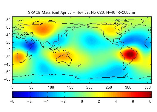
7 Estimation of basin-scale TWS, validation and uncertainty

8 Geoid trend
9

10 1. Basic principles of satellite altimetry Radar altimeters Radar altimeters derive a precise measurement of the round-trip time between the satellite and and infer the satellite-to-ocean range. IoE The Basics of Satellite Oceanography. 5. Oceanographic Applications: Radar-altimeters

11 Summary of altimeter missions

12 Atmospheric absorption odin.physastro.mnsu.edu/~eskridge/astr101/atmospheric_windows.jpg 2.2cm (Ku-band)
13 Altimeter physics: pulse-limited For Geosat: pulse width: t p =3 ns corresponding to a bandwidth of 0.3 GHz and ~1700 pulses/sec. H = 800km H Range = ct/2 where t=5ms L p = ct p = 3x10 8 x 3ns = 1m Since ((A/2) 2 +H 2 )=(L p +H) 2 A = (HL p /2) 1/2 = 2.4km footprint!
14 1. Basic principles of satellite altimetry Interaction of the pulse of duration τ with a smooth sea surface. For an altimeter in a 1000-km orbit a pulse duration of about 3 ns would lead to a footprint of diameter 2.8 km. IoE The Basics of Satellite Oceanography. 5. Oceanographic Applications: Radar-altimeters
15 Modeling the impact of surface waves
16 Pr obability distribution : G( h) e if h = ct w / 2 where t w 2 h ( 2 h is wave contrib. to 2 ) ; h 1/ 3 = 4 h pulse width then G( t w ) e 2 c tw ( 8 h 2 2 ) if t w G( t w 4 h = c ) 1/ 2 then (ln 2) 1/ 2 = h c 1/ 3 (ln 2) 1/ 2 If h 1/3 = 2m then t w = 3ns and the footprint expands to 3.5km
17 Additional issues Need to average To get 2cm accuracy when a single pulse only resolves ~ 1m we need to average 10 4 pulses (assumes random heights!). At 1700 pulses/sec this means we need to average ~ 5 sec. Because of the rate of travel of the satellite this means we cannot resolve features at finer than 25km resolution along-track! Need to adjust gate timing The pulses are tracked by electronic gates. Over land and ice the timing varies so much that Geosat and Topex altimeters lose lock on the pulses and must re-acquire ERS- 1/2 altimeters are better able to track over land.
18 Effect of averaging radar pulses Stammer, Observing the ocean using satellite altimeter data unpublished
19 1. Basic principles of satellite altimetry As a result of random distribution of the ocean wave facets at any instant, each individual return signal is very noisy, but averaging many successive pulses can reduce this. IoE The Basics of Satellite Oceanography. 5. Oceanographic Applications: Radar-altimeters
20 Modeling radar returns Empirical 3-parameter Brown model of pulse shape σ o range 2 t = t p + t w 2
21 Differences 3. Sea Surface between Height ascending and descending 37 N tracks 36 N 35 N 34 N Tracks of TOPEX/Poseidon The TOPEX/Poseidon truck numbers off southern California 33 N 32 N N N 29 N 195 IoE238 E The Basics 240 E of Satellite Oceanography. 242 E 5. Oceanographic 244 E 246 E Applications: Radar-altimeters 17
22 Measurement/geophysical errors Sea State Bias: troughs of the waves preferentially reflect back toward radar. Lowers estimated sea level by ~0.05H 1/3 leading to a m bias Ionospheric Delay - electron plasma in the ionosphere slows radar pulses. Smallest at 6 AM largest at 12 noon. Dual frequency radars correct for this at > 50 km scales. Dry Atmosphere dry atmosphere slows radar pulses (function of index of refraction. Typically ~2.3 m Wet troposphere humidity further delays radar pulses. Typically ~ m Orbit Error lack of knowledge of the orbital position used to cause ~1m errors. Corrected for by use of repeat tracks and wavenumber filtering. With GPS tracking this error is now ~0.02m.


23 Geophysical corrections Wet tropospheric water vapor correction Dry atmosphere correction Ionospheric correction mm


24 Orbit Error 10-dy T/P orbit tracks
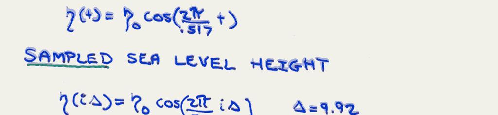
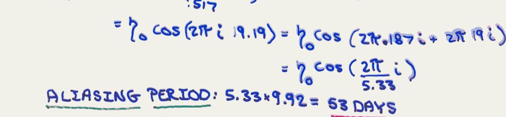
25 Tidal aliasing Before correction Cheney et al. (1994)

26

27 3. Sea Surface Height Hurricane Rita in the Gulf of Mexico. Elevated SSH demonstrates warm water heating the hurricane. IoE The Basics of Satellite Oceanography. 5. Oceanographic Applications: Radar-altimeters
 Altitude:")

28 Icesat ( ) (laser beam-limited altimeter) Altitude: 705km Orbit: near-polar Footprint: 70 m Separation between footprints: 170m

29 Scatterometry, Satellite ocean winds Scatterometer measures the normalized radar cross-section of the ocean surface (by comparing the power of transmitted and returned signals) from which the near-surface wind is estimated. Radar crosssection is a function of the ocean surface roughness which is created primarily by wind-generated waves. Thus wind speed and direction can be inferred.
30 Scatterometry: exploiting σ o
31 D=λ B *sin(θ)=λ/2 If incoming microwave wavelength is of the order of a few cm, the Bragg wavelength is also of the order of a few cm D Bragg waves are in balance with local winds Bragg scattering: A plan-parallel radar beam with wavelength λ hits the rough ocean surface at incidence angle θ, where capillary gravity waves with Bragg wavelength λ B will cause microwave resonance.
32 4. Sea Surface Roughness - Oblique-viewing microwave radiometers Microwave scatterometer is based on the principle of the resonant Bragg scattering. For a smooth surface, oblique viewing of the surface with active radar yields virtually no return. If the surface is rough, significant backscatter occurs. IoE The Basics of Satellite Oceanography. 5. Oceanographic Applications: Radar-altimeters

33 Geophysical model functions where τ = ρu* 2

34 Dependence of σ o on viewing angle and polarization
35 ERS1/2 and QuikSCAT designs ERS Satellite Satellite Orbit 57º 785 km Fore Beam 25º 18º 45.5º 45º Mid-Beam 45º 45º Ground Track node 0 node 18 Aft Beam ~200 km 19 nodes 25 km apart C-band (5GHz) ERS1/2 Ku-band (14GHz) QuikSCAT
36 Scatterometer wind direction retrieval Discrete angular beams Conical angular scanning. SeaWinds viewing geometry. Image courtesy of Spencer, Wu, and Long (2000).
37 Differences between ERS1/2 and QSCAT Random error Speed ±2m/s Direction: ±20 o Altitude: 803 km Footprint: 25km Swath width: 1,800 km Coverage: 90% of Earth's surface in one day,

38 Katrina (Category 4) QuikSCAT winds 8-29 at landfall.

39 4-year mean Divergence and curl Chelton et al, Science, 2004:

40 Detail in the South Atlantic Winds around AOSC424 South Georgia - Carton showing island effects
41 Synthetic Aperture RADAR exploits the different doppler freq associated with different angles For 5.3 GHz (C-Band) use of SAR reduces effective resolution from 30 km to 9m. Wind speed ml

42

43 Ice flow detection with SAR Ice floes appear darker due to the presence of a layer of melt water overlying the ice surface The presence of this water layer decreases backscatter toward the radar system, resulting in a darker appearance Slide curtesy: Ken Pryor NOAA/NESDIS/STAR

44 Internal tide fronts
45 References Lee-Lueng Fu (Editor), Anny Cazenave, Satellite Altimetry and Earth Sciences: A Handbook of Techniques and Applications, 2000 NASA tutorial: UIUC tutorial: Lillesand, T.M., and R.W. Kiefer, Remote Sensing and Image Interpretation, 724 pp., John Wiley and Sons, Inc., New York, 2000.
Remote Sensing: John Wilkin IMCS Building Room 211C ext 251. Active microwave systems (1) Satellite Altimetry
 Satellite Altimetry") Remote Sensing: John Wilkin wilkin@marine.rutgers.edu IMCS Building Room 211C 732-932-6555 ext 251 Active microwave systems (1) Satellite Altimetry Active microwave instruments Scatterometer (scattering
Remote Sensing: John Wilkin wilkin@marine.rutgers.edu IMCS Building Room 211C 732-932-6555 ext 251 Active microwave systems (1) Satellite Altimetry Active microwave instruments Scatterometer (scattering
Active microwave systems (2) Satellite Altimetry * range data processing * applications
 Satellite Altimetry * range data processing * applications") Remote Sensing: John Wilkin wilkin@marine.rutgers.edu IMCS Building Room 211C 732-932-6555 ext 251 Active microwave systems (2) Satellite Altimetry * range data processing * applications Satellite Altimeters
Remote Sensing: John Wilkin wilkin@marine.rutgers.edu IMCS Building Room 211C 732-932-6555 ext 251 Active microwave systems (2) Satellite Altimetry * range data processing * applications Satellite Altimeters
Active microwave systems (1) Satellite Altimetry
 Satellite Altimetry") Remote Sensing: John Wilkin Active microwave systems (1) Satellite Altimetry jwilkin@rutgers.edu IMCS Building Room 214C 732-932-6555 ext 251 Active microwave instruments Scatterometer (scattering from
Remote Sensing: John Wilkin Active microwave systems (1) Satellite Altimetry jwilkin@rutgers.edu IMCS Building Room 214C 732-932-6555 ext 251 Active microwave instruments Scatterometer (scattering from
Altimeter Range Corrections
 Altimeter Range Corrections Schematic Summary Corrections Altimeters Range Corrections Altimeter range corrections can be grouped as follows: Atmospheric Refraction Corrections Sea-State Bias Corrections
SATELLITE OCEANOGRAPHY
 SATELLITE OCEANOGRAPHY An Introduction for Oceanographers and Remote-sensing Scientists I. S. Robinson Lecturer in Physical Oceanography Department of Oceanography University of Southampton JOHN WILEY
A short course on Altimetry
 1 A short course on Altimetry Paolo Cipollini 1, Helen Snaith 2 1 National Oceanography Centre, Southampton, U.K. 2 British Oceanographic Data Centre, Southampton, U.K. with contributions by Peter Challenor,
Microwave Remote Sensing
 Provide copy on a CD of the UCAR multi-media tutorial to all in class. Assign Ch-7 and Ch-9 (for two weeks) as reading material for this class. HW#4 (Due in two weeks) Problems 1,2,3 and 4 (Chapter 7)
Passive Microwave Sensors LIDAR Remote Sensing Laser Altimetry. 28 April 2003
 Passive Microwave Sensors LIDAR Remote Sensing Laser Altimetry 28 April 2003 Outline Passive Microwave Radiometry Rayleigh-Jeans approximation Brightness temperature Emissivity and dielectric constant
Microwave Remote Sensing (1)
") Microwave Remote Sensing (1) Microwave sensing encompasses both active and passive forms of remote sensing. The microwave portion of the spectrum covers the range from approximately 1cm to 1m in wavelength.
Microwave Remote Sensing (1) Microwave sensing encompasses both active and passive forms of remote sensing. The microwave portion of the spectrum covers the range from approximately 1cm to 1m in wavelength.
INTERDISCIPLINARY SCIENCE AND APPLICATIONS USING SATELLITE RADAR ALTIMETRY
 NASA NASA ESA ESA JAXA NAS A INTERDISCIPLINARY SCIENCE AND APPLICATIONS USING SATELLITE RADAR ALTIMETRY C.K. SHUM EE Wave Propagation and Remote Sensing Joel Johnson November 14, 2012 Measurement Coverage:
Waveform Processing of Nadir-Looking Altimetry Data
 Waveform Processing of Nadir-Looking Altimetry Data Mònica Roca and Richard Francis ESA/ESTEC Noordwijk The Netherlands Contents 1. the concept 2. introduction 3. the on-board waveform [how the return
Sea-state effects on Satellite Altimetry Overview of established models and recent developments
 Sea-state effects on Satellite Altimetry Overview of established models and recent developments Nelson PIRES 1*, Joana FERNANDES 1, Christine GOMMENGINGER 2 e Remko SCHARROO 3 1 DGAOT, Faculdade de Ciências,
Sea Surface Temperature! Science Team!
 Science Team Introduction Sea Surface Temperature! Science Team! Eric Lindstrom NASA Science Mission Directorate Earth Science Division 8 November 2010 THANK YOU! To the Steering Team Andy Jessup & Peter
EE 529 Remote Sensing Techniques. Introduction
 EE 529 Remote Sensing Techniques Introduction Course Contents Radar Imaging Sensors Imaging Sensors Imaging Algorithms Imaging Algorithms Course Contents (Cont( Cont d) Simulated Raw Data y r Processing
Radar Reprinted from "Waves in Motion", McGourty and Rideout, RET 2005
 Radar Reprinted from "Waves in Motion", McGourty and Rideout, RET 2005 What is Radar? RADAR (Radio Detection And Ranging) is a way to detect and study far off targets by transmitting a radio pulse in the
The Global Imager (GLI)
") The Global Imager (GLI) Launch : Dec.14, 2002 Initial check out : to Apr.14, 2003 (~L+4) First image: Jan.25, 2003 Second image: Feb.6 and 7, 2003 Calibration and validation : to Dec.14, 2003(~L+4) for
The Global Imager (GLI) Launch : Dec.14, 2002 Initial check out : to Apr.14, 2003 (~L+4) First image: Jan.25, 2003 Second image: Feb.6 and 7, 2003 Calibration and validation : to Dec.14, 2003(~L+4) for
Remote Sensing. Ch. 3 Microwaves (Part 1 of 2)
") Remote Sensing Ch. 3 Microwaves (Part 1 of 2) 3.1 Introduction 3.2 Radar Basics 3.3 Viewing Geometry and Spatial Resolution 3.4 Radar Image Distortions 3.1 Introduction Microwave (1cm to 1m in wavelength)
Remote Sensing Ch. 3 Microwaves (Part 1 of 2) 3.1 Introduction 3.2 Radar Basics 3.3 Viewing Geometry and Spatial Resolution 3.4 Radar Image Distortions 3.1 Introduction Microwave (1cm to 1m in wavelength)
Estimation of Ocean Current Velocity near Incheon using Radarsat-1 SAR and HF-radar Data
 Korean Journal of Remote Sensing, Vol.23, No.5, 2007, pp.421~430 Estimation of Ocean Current Velocity near Incheon using Radarsat-1 SAR and HF-radar Data Moon-Kyung Kang and Hoonyol Lee Department of Geophysics,
WorId Ocean Circulation Experiment
 WorId Ocean Circulation Experiment WOCE/NASA Altimeter Algorithm Workshop U.S. WOCE Technical Report Number 2 November, 1988 U.S. WOCE Science Steering Committee D. James Baker, Jr. (Joint Oceanographic
ELECTROMAGNETIC PROPAGATION (ALT, TEC)
") ELECTROMAGNETIC PROPAGATION (ALT, TEC) N. Picot CNES, 18 Av Ed Belin, 31401 Toulouse, France Email : Nicolas.Picot@cnes.fr ABSTRACT For electromagnetic propagation, the ionosphere plays a key role. This
ELECTROMAGNETIC PROPAGATION (ALT, TEC) N. Picot CNES, 18 Av Ed Belin, 31401 Toulouse, France Email : Nicolas.Picot@cnes.fr ABSTRACT For electromagnetic propagation, the ionosphere plays a key role. This
Are Radiometers and Scatterometers Seeing the Same Wind Speed?
 Are Radiometers and Scatterometers Seeing the Same Wind Speed? Frank J. Wentz and Thomas Meissner Remote Sensing Systems NASA Ocean Vector Wind Science Team Meeting May 18-, 9 Boulder, CO Radiometer and
Earth Remote Sensing using Surface-Reflected GNSS Signals (Part II)
") Jet Propulsion Laboratory California Institute of Technology National Aeronautics and Space Administration Jet Propulsion Laboratory California Institute of Technology Pasadena, California Earth Remote
Jet Propulsion Laboratory California Institute of Technology National Aeronautics and Space Administration Jet Propulsion Laboratory California Institute of Technology Pasadena, California Earth Remote
Microwave Sensors Subgroup (MSSG) Report
 Report") Microwave Sensors Subgroup (MSSG) Report Feb 17-20, 2014, ESA ESRIN, Frascati, Italy DONG, Xiaolong, MSSG Chair National Space Science Center Chinese Academy of Sciences (MiRS,NSSC,CAS) Email: dongxiaolong@mirslab.cn
Microwave Sensors Subgroup (MSSG) Report Feb 17-20, 2014, ESA ESRIN, Frascati, Italy DONG, Xiaolong, MSSG Chair National Space Science Center Chinese Academy of Sciences (MiRS,NSSC,CAS) Email: dongxiaolong@mirslab.cn
Synthetic aperture RADAR (SAR) principles/instruments October 31, 2018
 principles/instruments October 31, 2018") GEOL 1460/2461 Ramsey Introduction to Remote Sensing Fall, 2018 Synthetic aperture RADAR (SAR) principles/instruments October 31, 2018 I. Reminder: Upcoming Dates lab #2 reports due by the start of next
GEOL 1460/2461 Ramsey Introduction to Remote Sensing Fall, 2018 Synthetic aperture RADAR (SAR) principles/instruments October 31, 2018 I. Reminder: Upcoming Dates lab #2 reports due by the start of next
UNERSITY OF NAIROBI UNIT: PRICIPLES AND APPLICATIONS OF REMOTE SENSING AND APLLIED CLIMATOLOGY
 UNERSITY OF NAIROBI DEPARTMENT OF METEOROLOGY UNIT: PRICIPLES AND APPLICATIONS OF REMOTE SENSING AND APLLIED CLIMATOLOGY COURSE CODE: SMR 308 GROUP TWO: SENSORS MEMBERS OF GROUP TWO 1. MUTISYA J.M I10/2784/2006
Concept Design of Space-Borne Radars for Tsunami Detection
 Concept Design of Space-Borne Radars for Tsunami Detection DLR German Aerospace Agency +Microwaves and Radar Institute *Remote Sensing Institute +Michele Galletti +Gerhard Krieger +Nicolas Marquart +Thomas
ESA Radar Remote Sensing Course ESA Radar Remote Sensing Course Radar, SAR, InSAR; a first introduction
 Radar, SAR, InSAR; a first introduction Ramon Hanssen Delft University of Technology The Netherlands r.f.hanssen@tudelft.nl Charles University in Prague Contents Radar background and fundamentals Imaging
China. France Oceanography S A T. Overview of the near-real time wave products of the CFOSAT mission. e l l i t e
 China Overview of the near-real time wave products of the CFOSAT mission C. Tison (1), D. Hauser (2), S. Guibert (1), T. Amiot (1), L. Aouf (3), J.M. Lefèvre (3), B. Chapron (5), N. Corcoral (1), P. Castillan
Aquarius/SAC-D Mission Mission Simulators - Gary Lagerloef 6 th Science Meeting; Seattle, WA, USA July 2010
 Aquarius/SAC-D Mission Mission Simulators - Gary Lagerloef 6 th Science Meeting; Seattle, WA, USA Mission Design and Sampling Strategy Sun-synchronous exact repeat orbit 6pm ascending node Altitude 657
Microwave Sensors Subgroup (MSSG) Report
 Report") Microwave Sensors Subgroup (MSSG) Report CEOS WGCV-35 May 13-17, 2013, Shanghai, China DONG, Xiaolong, MSSG Chair CAS Key Laboratory of Microwave Remote Sensing National Space Science Center Chinese Academy
Microwave Sensors Subgroup (MSSG) Report CEOS WGCV-35 May 13-17, 2013, Shanghai, China DONG, Xiaolong, MSSG Chair CAS Key Laboratory of Microwave Remote Sensing National Space Science Center Chinese Academy
The Delay-Doppler Altimeter
 Briefing for the Coastal Altimetry Workshop The Delay-Doppler Altimeter R. K. Raney Johns Hopkins University Applied Physics Laboratory 05-07 February 2008 1 What is a Delay-Doppler altimeter? Precision
Dr. Sandra L. Cruz Pol
 OUTLINE INTRODUCTION TO MICROWAVE REMOTE SENSING INEL 8695/6669 Dr. Sandra Cruz Pol Microwave Remote Sensing INEL 6669/8695 Dept. of Electrical & Computer Engineering, UPRM, Mayagüez, PR Importance of
ESCI Cloud Physics and Precipitation Processes Lesson 10 - Weather Radar Dr. DeCaria
 ESCI 340 - Cloud Physics and Precipitation Processes Lesson 10 - Weather Radar Dr. DeCaria References: A Short Course in Cloud Physics, 3rd ed., Rogers and Yau, Ch. 11 Radar Principles The components of
746A27 Remote Sensing and GIS
 746A27 Remote Sensing and GIS Lecture 1 Concepts of remote sensing and Basic principle of Photogrammetry Chandan Roy Guest Lecturer Department of Computer and Information Science Linköping University What
Remote Sensing 1 Principles of visible and radar remote sensing & sensors
 Remote Sensing 1 Principles of visible and radar remote sensing & sensors Nick Barrand School of Geography, Earth & Environmental Sciences University of Birmingham, UK Field glaciologist collecting data
Introduction Active microwave Radar
 RADAR Imaging Introduction 2 Introduction Active microwave Radar Passive remote sensing systems record electromagnetic energy that was reflected or emitted from the surface of the Earth. There are also
ATS 351 Lecture 9 Radar
 ATS 351 Lecture 9 Radar Radio Waves Electromagnetic Waves Consist of an electric field and a magnetic field Polarization: describes the orientation of the electric field. 1 Remote Sensing Passive vs Active
Improvement and Validation of Ranging Accuracy with YG-13A
 Article Improvement and Validation of Ranging Accuracy with YG-13A Mingjun Deng 1, Guo Zhang 2, *, Ruishan Zhao 3, Jiansong Li 1, Shaoning Li 2 1 School of Remote Sensing and Information Engineering, Wuhan
CEGEG046 / GEOG3051 Principles & Practice of Remote Sensing (PPRS) 8: RADAR 1
 8: RADAR 1") CEGEG046 / GEOG3051 Principles & Practice of Remote Sensing (PPRS) 8: RADAR 1 Dr. Mathias (Mat) Disney UCL Geography Office: 113, Pearson Building Tel: 7670 05921 Email: mdisney@ucl.geog.ac.uk www.geog.ucl.ac.uk/~mdisney
CEGEG046 / GEOG3051 Principles & Practice of Remote Sensing (PPRS) 8: RADAR 1 Dr. Mathias (Mat) Disney UCL Geography Office: 113, Pearson Building Tel: 7670 05921 Email: mdisney@ucl.geog.ac.uk www.geog.ucl.ac.uk/~mdisney
MONITORING SEA LEVEL USING GPS
 38 MONITORING SEA LEVEL USING GPS Hasanuddin Z. Abidin* Abstract GPS (Global Positioning System) is a passive, all-weather satellite-based navigation and positioning system, which is designed to provide
CNES PRIORITIES IN POLAR AND CRYOSPHERE RESEARCH
 Polar Space Task Group 3rd Session CNES PRIORITIES IN POLAR AND CRYOSPHERE RESEARCH Juliette Lambin, Steven Hosford Wednesday, May 22th, 2013 Paris, France 1 OUTLINE CNES MISSIONS FOR POLAR/CRYOSPHERE
Specificities of Near Nadir Ka-band Interferometric SAR Imagery
 Specificities of Near Nadir Ka-band Interferometric SAR Imagery Roger Fjørtoft, Alain Mallet, Nadine Pourthie, Jean-Marc Gaudin, Christine Lion Centre National d Etudes Spatiales (CNES), France Fifamé
Ocean SAR altimetry. from SIRAL2 on CryoSat2 to Poseidon-4 on Jason-CS
 Ocean SAR altimetry from SIRAL2 on CryoSat2 to Poseidon-4 on Jason-CS Template reference : 100181670S-EN L. Phalippou, F. Demeestere SAR Altimetry EGM NOC, Southampton, 26 June 2013 History of SAR altimetry
Calibration of RapidScat Instrument Drift. F. Dayton Minor
 Calibration of RapidScat Instrument Drift F. Dayton Minor A thesis submitted to the faculty of Brigham Young University in partial fulfillment of the requirements for the degree of Master of Science David
Introduction to Microwave Remote Sensing
 Introduction to Microwave Remote Sensing lain H. Woodhouse The University of Edinburgh Scotland Taylor & Francis Taylor & Francis Group Boca Raton London New York A CRC title, part of the Taylor & Francis
OBSERVATION PERFORMANCE OF A PARIS ALTIMETER IN-ORBIT DEMONSTRATOR
 OBSERVATION PERFORMANCE OF A PARIS ALTIMETER IN-ORBIT DEMONSTRATOR Salvatore D Addio, Manuel Martin-Neira Acknowledgment to: Nicolas Floury, Roberto Pietro Cerdeira TEC-ETP, ETP, Electrical Engineering
ECE Lecture 32
 ECE 5010 - Lecture 32 1 Microwave Radiometry 2 Properties of a Radiometer 3 Radiometric Calibration and Uncertainty 4 Types of Radiometer Measurements Levis, Johnson, Teixeira (ESL/OSU) Radiowave Propagation
Copernicus Introduction Lisbon, Portugal 13 th & 14 th February 2014
 Copernicus Introduction Lisbon, Portugal 13 th & 14 th February 2014 Contents Introduction GMES Copernicus Six thematic areas Infrastructure Space data An introduction to Remote Sensing In-situ data Applications
Rec. ITU-R P RECOMMENDATION ITU-R P *
 Rec. ITU-R P.682-1 1 RECOMMENDATION ITU-R P.682-1 * PROPAGATION DATA REQUIRED FOR THE DESIGN OF EARTH-SPACE AERONAUTICAL MOBILE TELECOMMUNICATION SYSTEMS (Question ITU-R 207/3) Rec. 682-1 (1990-1992) The
New concepts for space-borne Tsunami early warning using microwave sensors
 GITEWS New concepts for space-borne Tsunami early warning using microwave sensors Dr. Thomas Börner Microwaves and Radar Institute (IHR) German Aerospace Center (DLR) Overview Conceiving and designing
3/31/03. ESM 266: Introduction 1. Observations from space. Remote Sensing: The Major Source for Large-Scale Environmental Information
 Remote Sensing: The Major Source for Large-Scale Environmental Information Jeff Dozier Observations from space Sun-synchronous polar orbits Global coverage, fixed crossing, repeat sampling Typical altitude
remote sensing? What are the remote sensing principles behind these Definition
 Introduction to remote sensing: Content (1/2) Definition: photogrammetry and remote sensing (PRS) Radiation sources: solar radiation (passive optical RS) earth emission (passive microwave or thermal infrared
Design and Performance Simulation of a Ku-Band Rotating Fan-Beam Scatterometer
 Design and Performance Simulation of a Ku-Band Rotating Fan-Beam Scatterometer Xiaolong DONG, Wenming LIN, Di ZHU, (CSSAR/CAS) PO Box 8701, Beijing, 100190, China Tel: +86-10-62582841, Fax: +86-10-62528127
Monitoring the Earth Surface from space
 Monitoring the Earth Surface from space Picture of the surface from optical Imagery, i.e. obtained by telescopes or cameras operating in visual bandwith. Shape of the surface from radar imagery Surface
Microwave sensors (present and future)
") Proc. Indian Acad. Sci. (Engg. sea.), Vol. 6, Pt. 2, June 1983, pp. 109-119. 9 Printed in India. Microwave sensors (present and future) 1. Introduction O P N CALLA Communications Area, Space Applications
Proc. Indian Acad. Sci. (Engg. sea.), Vol. 6, Pt. 2, June 1983, pp. 109-119. 9 Printed in India. Microwave sensors (present and future) 1. Introduction O P N CALLA Communications Area, Space Applications
Outline. Introduction. Introduction: Film Emulsions. Sensor Systems. Types of Remote Sensing. A/Prof Linlin Ge. Photographic systems (cf(
 GMAT x600 Remote Sensing / Earth Observation Types of Sensor Systems (1) Outline Image Sensor Systems (i) Line Scanning Sensor Systems (passive) (ii) Array Sensor Systems (passive) (iii) Antenna Radar
Solid Earth Timeline with a smattering of cryosphere technology
 Solid Earth Timeline with a smattering of cryosphere technology Muhammed Kabiru Hassan * Rebecca Boon Image from http://www.clipartheaven.com/show/clipart/technology_&_communication/satellites/satellite_23-gif.html
Wide Swath Simultaneous Measurements of Winds and Ocean Surface Currents
 Wide Swath Simultaneous Measurements of Winds and Ocean Surface Currents Ernesto Rodriguez Jet Propulsion Laboratory California Institute of Technology 1 Thanks! The JPL DFS/ERM team for design of the
High-resolution measurements with a spaceborne pencil-beam scatterometer using combined range/ Doppler discrimination techniques
 Brigham Young University BYU ScholarsArchive All Faculty Publications 2003-03-01 High-resolution measurements with a spaceborne pencil-beam scatterometer using combined range/ Doppler discrimination techniques
ADDITIONAL SATELLITE AND SENSORS
 ADDITIONAL SATELLITE AND SENSORS A list of additional satellites and sensors, along with links to appropriate websites, is presented below. ACRIMSAT (Active Cavity Radiometer Irradiance Monitor Satellite)
ACTIVE SENSORS RADAR
 ACTIVE SENSORS RADAR RADAR LiDAR: Light Detection And Ranging RADAR: RAdio Detection And Ranging SONAR: SOund Navigation And Ranging Used to image the ocean floor (produce bathymetic maps) and detect objects
Antenna design for Space Applications M. Sabbadini European Space Agency, Noordwijk, The Netherlands
 Antenna design for Space Applications M. Sabbadini European Space Agency, Noordwijk, The Netherlands marco.sabbadini@esa.int Day 3 overview Array antennas in space Antennas for Earth observation Antennas
Synthetic Aperture Radar for Rapid Flood Extent Mapping
 National Aeronautics and Space Administration ARSET Applied Remote Sensing Training http://arset.gsfc.nasa.gov @NASAARSET Synthetic Aperture Radar for Rapid Flood Extent Mapping Sang-Ho Yun ARIA Team Jet
Active and Passive Microwave Remote Sensing
 Active and Passive Microwave Remote Sensing Passive remote sensing system record EMR that was reflected (e.g., blue, green, red, and near IR) or emitted (e.g., thermal IR) from the surface of the Earth.
ACTIVE MICROWAVE REMOTE SENSING OF LAND SURFACE HYDROLOGY
 Basics, methods & applications ACTIVE MICROWAVE REMOTE SENSING OF LAND SURFACE HYDROLOGY Annett.Bartsch@polarresearch.at Active microwave remote sensing of land surface hydrology Landsurface hydrology:
GNSS remote sensing (GNSS-RS)
") GPS Galileo GLONASS Beidou GNSS remote sensing (GNSS-RS) Shuanggen Jin ( 金双根 ) Shanghai Astronomical Observatory, CAS, Shanghai 200030, China Email: sgjin@shao.ac.cn Website: http://www.shao.ac.cn/geodesy
GPS Galileo GLONASS Beidou GNSS remote sensing (GNSS-RS) Shuanggen Jin ( 金双根 ) Shanghai Astronomical Observatory, CAS, Shanghai 200030, China Email: sgjin@shao.ac.cn Website: http://www.shao.ac.cn/geodesy
MODULE 9 LECTURE NOTES 1 PASSIVE MICROWAVE REMOTE SENSING
 MODULE 9 LECTURE NOTES 1 PASSIVE MICROWAVE REMOTE SENSING 1. Introduction The microwave portion of the electromagnetic spectrum involves wavelengths within a range of 1 mm to 1 m. Microwaves possess all
Scientific Applications of Fully-Focused SAR Altimetry
 Scientific Applications of Fully-Focused SAR Altimetry Alejandro Egido (1,2), Walter Smith (2) (1) UMD/CICS-MD, United States (2) NOAA, United States CICS Science Conference Nov 29, 30 & Dec 1, 2016 College
GNSS Remote Sensing: CubeSat case study
 GNSS Remote Sensing: CubeSat case study P-GRESSION system and its background at PoliTo CubeSat Team Lorenzo Feruglio PhD student, Aerospace Engineering LIST OF ACRONYMS LIST OF FIGURES Introduction GNSS
ESRIN-EOP-GMQ / IDEAS+ Version September Geophysical Corrections in Level 2 CryoSat Data Products
 ESRIN-EOP-GMQ / IDEAS+ Version 5.1 28 September 2016 Geophysical Corrections in Level 2 CryoSat Data Products Prepared by Erica Webb, Amanda Hall (IDEAS+, CryoSat QC Team) Checked by Jerome Bouffard (ESA,
Earth Observation from a Moon based SAR: Potentials and Limitations
 Earth Observation from a Moon based SAR: Potentials and Limitations F. Bovenga 1, M. Calamia 2,3, G. Fornaro 5, G. Franceschetti 4, L. Guerriero 1, F. Lombardini 5, A. Mori 2 1 Politecnico di Bari - Dipartimento
10 Radar Imaging Radar Imaging
 10 Radar Imaging Active sensors provide their own source of energy to illuminate the target. Active sensors are generally divided into two distinct categories: imaging and non-imaging. The most common
Tracking and Retracking
 Tracking and Retracking W.H.F. Smith With contributions from P. Thibaut and P. Berry, L. Fenoglio-Marc Concurring: Birkett, Callahan, Dorandeu, Lambin, Martin, Raney, Rodriguez, Zanife CIOSS/NOAA Coastal
Improved resolution backscatter measurements with the SeaWinds pencil-beam scatterometer
 Brigham Young University BYU ScholarsArchive All Faculty Publications 2000-01-01 Improved resolution backscatter measurements with the SeaWinds pencil-beam scatterometer David G. Long david_long@byu.edu
High-Resolution Measurements With a Spaceborne Pencil-Beam Scatterometer Using Combined Range/Doppler Discrimination Techniques
 IEEE TRANSACTIONS ON GEOSCIENCE AND REMOTE SENSING, VOL. 41, NO. 3, MARCH 2003 567 High-Resolution Measurements With a Spaceborne Pencil-Beam Scatterometer Using Combined Range/Doppler Discrimination Techniques
Active and Passive Microwave Remote Sensing
 Active and Passive Microwave Remote Sensing Passive remote sensing system record EMR that was reflected (e.g., blue, green, red, and near IR) or emitted (e.g., thermal IR) from the surface of the Earth.
2 INTRODUCTION TO GNSS REFLECTOMERY
 2 INTRODUCTION TO GNSS REFLECTOMERY 2.1 Introduction The use of Global Navigation Satellite Systems (GNSS) signals reflected by the sea surface for altimetry applications was first suggested by Martín-Neira
Sea surface temperature observation through clouds by the Advanced Microwave Scanning Radiometer 2
 Sea surface temperature observation through clouds by the Advanced Microwave Scanning Radiometer 2 Akira Shibata Remote Sensing Technology Center of Japan (RESTEC) Tsukuba-Mitsui blds. 18F, 1-6-1 Takezono,
2012 International Ocean Vector Wind ST Meeting Utrecht, Netherlands, May 2012
 2012 International Ocean Vector Wind ST Meeting Utrecht, Netherlands, 12-14 May 2012 NASA Programmatic Perspectives: Present Status and the Way Forward Peter Hacker and Eric Lindstrom NASA Science Mission
Radar observables: Target range Target angles (azimuth & elevation) Target size (radar cross section) Target speed (Doppler) Target features (imaging)
 Target size (radar cross section) Target speed (Doppler) Target features (imaging)") Fundamentals of Radar Prof. N.V.S.N. Sarma Outline 1. Definition and Principles of radar 2. Radar Frequencies 3. Radar Types and Applications 4. Radar Operation 5. Radar modes What What is is Radar? Radar?
Fundamentals of Radar Prof. N.V.S.N. Sarma Outline 1. Definition and Principles of radar 2. Radar Frequencies 3. Radar Types and Applications 4. Radar Operation 5. Radar modes What What is is Radar? Radar?
RADAR DEVELOPMENT BASIC CONCEPT OF RADAR WAS DEMONSTRATED BY HEINRICH. HERTZ VERIFIED THE MAXWELL RADAR.
 1 RADAR WHAT IS RADAR? RADAR (RADIO DETECTION AND RANGING) IS A WAY TO DETECT AND STUDY FAR OFF TARGETS BY TRANSMITTING A RADIO PULSE IN THE DIRECTION OF THE TARGET AND OBSERVING THE REFLECTION OF THE
Imaging radar Imaging radars provide map-like coverage to one or both sides of the aircraft.
 CEE 6100 / CSS 6600 Remote Sensing Fundamentals 1 Imaging radar Imaging radars provide map-like coverage to one or both sides of the aircraft. Acronyms: RAR real aperture radar ("brute force", "incoherent")
An Introduction to Remote Sensing & GIS. Introduction
 An Introduction to Remote Sensing & GIS Introduction Remote sensing is the measurement of object properties on Earth s surface using data acquired from aircraft and satellites. It attempts to measure something
How to access EO data
 How to access EO data PAC USF USF PDHS LRAC USCF PDCC Europe s expanding EO Capability Continuity & Evolution Wind Scatterometer (Low rate) all weather; day and night SAR Antenna (C-Band, 5.3 GHz) image
Thomas Meissner, Frank Wentz, Kyle Hilburn Remote Sensing Systems
 Thomas Meissner, Frank Wentz, Kyle Hilburn Remote Sensing Systems meissner@remss.com presented at the 8th Aquarius/SAC-D Science Team Meeting November 12-14, 2013 Buenos Aires, Argentina 1. Improved Surface
GNSS Reflectometry and Passive Radar at DLR
 ACES and FUTURE GNSS-Based EARTH OBSERVATION and NAVIGATION 26./27. May 2008, TU München Dr. Thomas Börner, Microwaves and Radar Institute, DLR Overview GNSS Reflectometry a joined proposal of DLR and
SOUTHAMPTON OCEANOGRAPHY CENTRE. INTERNAL DOCUMENT No. 53. Global Altimeter Processing Scheme User Manual: v1. H Snaith
 SOUTHAMPTON OCEANOGRAPHY CENTRE INTERNAL DOCUMENT No. 53 Global Altimeter Processing Scheme User Manual: v1 H Snaith 2000 James Rennell Division for Ocean Circulation and Climate Southampton Oceanography
Remote sensing radio applications/ systems for environmental monitoring
 Remote sensing radio applications/ systems for environmental monitoring Alexandre VASSILIEV ITU Radiocommunication Bureau phone: +41 22 7305924 e-mail: alexandre.vassiliev@itu.int 1 Source: European Space
DOPPLER RADAR. Doppler Velocities - The Doppler shift. if φ 0 = 0, then φ = 4π. where
 Q: How does the radar get velocity information on the particles? DOPPLER RADAR Doppler Velocities - The Doppler shift Simple Example: Measures a Doppler shift - change in frequency of radiation due to
Sea Surface Backscatter Distortions of Scanning Radar Altimeter Ocean Wave Measurements
 Sea Surface Backscatter Distortions of Scanning Radar Altimeter Ocean Wave Measurements Edward J. Walsh and C. Wayne Wright NASA Goddard Space Flight Center Wallops Flight Facility Wallops Island, VA 23337
Errors in GPS. Errors in GPS. Geodetic Co-ordinate system. R. Khosla Fall Semester
 Errors in GPS Errors in GPS GPS is currently the most accurate positioning system available globally. Although we are talking about extreme precision and measuring distances by speed of light, yet there
GNSS Ocean Reflected Signals
 GNSS Ocean Reflected Signals Per Høeg DTU Space Technical University of Denmark Content Experimental setup Instrument Measurements and observations Spectral characteristics, analysis and retrieval method
EnviSat ENVISAT RA-2 AND MWR PRODUCTS AND ALGORITHMS USER GUIDE. Doc. No.: RA-TN-ESR-GS-0013 Issue: 1.0 Date: 4 April 2000 Page: 1 / 13
 Page: 1 / ENVISAT RA-2 AND MWR PRODUCTS AND ALGORITHMS USER GUIDE J. Benveniste and M.P. Milagro ESA/ESRIN 1 Page: 2 / Table of Content 1 Scope..3 2 Instruments Overview.4 2.1 Second Generation Radar Altimeter
RECOMMENDATION ITU-R SA.1624 *
 Rec. ITU-R SA.1624 1 RECOMMENDATION ITU-R SA.1624 * Sharing between the Earth exploration-satellite (passive) and airborne altimeters in the aeronautical radionavigation service in the band 4 200-4 400
RECOMMENDATION ITU-R SA.1071* (Resolution No. 112, WARC-92)
") Rec. ITU-R SA.1071 1 RECOMMENDATION ITU-R SA.1071* USE OF THE 13.75 TO 14.0 GHz BAND BY THE SPACE SCIENCE SERVICES** AND THE FIXED-SATELLITE SERVICE (Resolution No. 112, WARC-92) Rec. ITU-R SA.1071 (1994)
Rec. ITU-R SA.1071 1 RECOMMENDATION ITU-R SA.1071* USE OF THE 13.75 TO 14.0 GHz BAND BY THE SPACE SCIENCE SERVICES** AND THE FIXED-SATELLITE SERVICE (Resolution No. 112, WARC-92) Rec. ITU-R SA.1071 (1994)
Multipath Analysis of the QuikSCAT Calibration Ground Station
 Brigham Young University Department of Electrical and Computer Engineering 459 Clyde Building Provo, Utah 8462 Multipath Analysis of the QuikSCAT Calibration Ground Station Arden Anderson 16 April 21 MERS
ECE Satellite Radar TRMM Precipitation Radar Cloud mm Radar - Cloudsat. Tropical Rainfall Measuring Mission
 Tropical Rainfall Measuring Mission ECE 583 18 Satellite Radar TRMM Precipitation Radar Cloud mm Radar - Cloudsat -TRMM includes 1st spaceborne weather radar - performs cross-track scan to get 3-D view
Radar Imaging Wavelengths
 A Basic Introduction to Radar Remote Sensing ~~~~~~~~~~ Rev. Ronald J. Wasowski, C.S.C. Associate Professor of Environmental Science University of Portland Portland, Oregon 3 November 2015 Radar Imaging
measurements from each beam are kept separate. We note that the variation in incidence angle over an orbit is small, typically less than a few tenths
 A QuikScat/SeaWinds Sigma-0 Browse Product David G. Long Microwave Earth Remote Sensing Laboratory BYU Center for Remote Sensing Brigham Young University 459 Clyde Building, Provo, UT 84602 long@ee.byu.edu