Remote Sensing: John Wilkin IMCS Building Room 211C ext 251. Active microwave systems (1) Satellite Altimetry
|
|
|
- Darren Griffin
- 6 years ago
- Views:
Transcription

1 Remote Sensing: John Wilkin IMCS Building Room 211C ext 251 Active microwave systems (1) Satellite Altimetry
2 Active microwave instruments Scatterometer (scattering from surface roughness) ocean vector winds Synthetic Aperture Radar (SAR) sea ice high resolution wind speed, surface roughness CODAR coastal ocean surface vector currents

3 Active microwave instruments Altimeters (nadir pointing radar) sea surface height (long wavelengths ~50 km) mesoscale currents, eddies, fronts thermal expansion significant wave height wind speed gravity and bathymetry ice sheets
4 Microwave energy is largely unaffected by the atmosphere: It has almost 100% transmission
5 Radar systems operate in the microwave region of the EM spectrum
6 Key Components of any Radar System Microwave transmitter electronic device used to generate the microwave EM energy transmitted by the radar Microwave receiver electronic device used to detect the microwave pulse that is reflected by the area being imaged by the radar Antenna electronic component through which microwave pulses are transmitted and received
7 The Radar Equation
8 The relationship between power received P and power transmitted P T is given by the radar equation P G R T P = 2 2 4π 4π (1) (2) (3) (1) Power of EM wave at range R. G = gain of antenna (2) Radiant intensity in the direction of the radar produced by scatter from a surface with a scattering cross-section σ (3) A e is antenna effective area σ R 1/(4πR 2 ) is isotropic spreading over range R A e
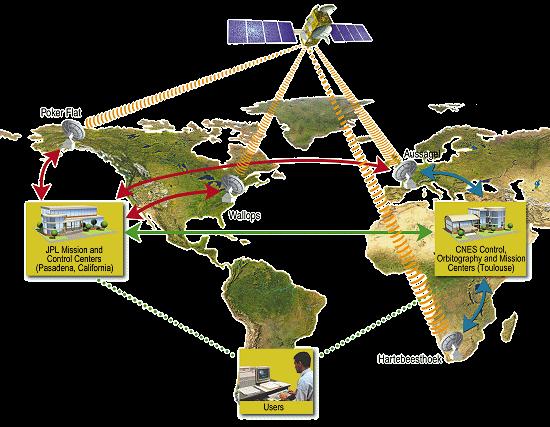
9 Satellite Altimeters altimeters are nadir-pointing satellite-based radars used to measure the height of the surface of the Earth transmit a radar pulse that is reflected from the Earth s surface measure the time it takes for the pulse to travel to Earth and back, t c = 3 x 10 8 m/s satellite altitude ~ 1200 km t = 2R/c = s = 8 milliseconds Poseidon uses 1700 pulses per second range from satellite to surface is R = ½ ct where c = speed of light Precision Orbit Determination (POD) systems measure the altitude of the satellite above a reference ellipsoid


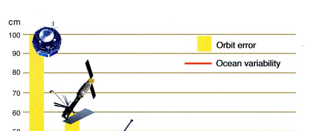
10 History of Altimetry Skylab Seasat 1978 Geosat Jason GFO Topex/ Poseidon Envisat
11 Altimetry: How it works Reference ellipsoid Satellite position is determined relative to an arbitrary reference surface, an ellipsoid. This reference ellipsoid is a raw approximation of Earth's surface, a sphere flattened at the poles. The altitude of Jason above the reference ellipsoid, distance S, is measured to within 3 cm.
12 Sea surface HEIGHT (SSH) Sea Surface Height is satellite altitude minus range It comprises two contributions: geoid and dynamic topography Geoid: The sea surface height that would exist without any motion. This surface is due to gravity variations around the planet due to mass and density differences on the seafloor Major bathymetric features deform sea level by tens of meters and are visible as a hill on the geoid Dynamic topography The ocean circulation comprises a permanent mean component linked to Earth's rotation, mean winds, and density patterns and a highly variable component (wind variability, tides, seasonal heating, eddies)
13 Sea surface HEIGHT (SSH) Sea Surface Height is satellite altitude minus range Geoid and dynamic topography: To derive the dynamic topography, D, the easiest way would be to subtract the geoid HEIGHT, G, from SSH In practice, the geoid is not yet known accurately enough for all applications and mean sea level is commonly subtracted instead. This yields the variable part of the ocean signal.

14
15
16 The slope of the sea surface relative to the geoid is directly related to the geostrophic current that balances the pressure gradient (due to the sea surface gradient) and the Coriolis force
17 Changes in sea surface topography Phenomenon Typical Surface Expression Period of Variability Comments Western boundary currents (Gulf Stream, Kuroshio) 130 cm/100 km Days to years Variability in position, and 25% variability in transport Large gyres 50 cm/ 3000 km One to many years Eastern boundary currents 25% variability expected 30 cm/100 km Days to years 100% variability expected, possible direction reversals Mesoscale eddies 25 cm/100 km 100 days 100% variability Rings 100 cm/100 km Weeks to years 100% variability, growth and decay Equatorial currents 30 cm/5000 km Months to years 100% variability Tides 100cm/5000 km Hours to years Aliased to low frequency
18 Jason satellite AVISO Web site

19 Jason launch movies

20 Satellite orbit and tracking The critical orbital parameters for satellite altimeter missions are altitude, inclination and period Topex/Poseidon and Jason satellites (same orbit) altitude 1336 km relatively high: less drag and more stable orbit inclination of 66 to Earth's polar axis it can "see" only up to 66 North and South the satellite repeats the same ground track every days the ground-tracks are 315 km apart at the equator track repeat precision is about 1km ground scanning velocity is 5.8 km/s, orbit velocity 7.2 km/s

21 Where is Topex now? Where is Jason now?
22
23 Geostrophic current computed from altimeter sea surface height gives only the component perpendicular to the ground-track. To get surface geostrophic current vectors we need to map the SSH field in two dimensions. The high alongtrack resolution (20km) is then lost because of the large separation of the ground-tracks (315 km at Equator) Where is Jason now?
 10")


24 (a) (b) (c) Grid of sea surface height measurements by T/P, ERS-2 and GFO in the Northeast Atlantic over (a) 10 days, (b) 7 days, and (c) and 3 days. There are gaps in coverage of 200 km and more over 3 days. Combining data from all three missions increases coverage. => Multiple satellites are required to resolve mesoscale current patterns
25 Altimetry: How it works For altimeter observations to be useful for oceanography, range accuracy of order 2 cm is required. Where is Jason now?
26 The challenges to achieving 2 cm accuracy are: computing the satellite position accurately range corrections for the atmosphere density of atmosphere, water vapor accounting for the aliasing of tides knowing the shape of a reference gravitational potential surface, or geoid, that defines a surface along which gravity is constant (and therefore dynamically level )
27 Precision Orbit Determination The Jason satellite is tracked in 3 ways 1. Turbo-Rogue Space Receiver (TRSR) continuously tracks up to 16 GPS satellites measures phase of carrier signals and pseudo-range (time) to estimates position to better than 20 m and time to 100 nanoseconds 2. Laser Retroflector Array (LRA) an array of mirrors on the satellite that provide a target for lasertracking measurements from ground stations round-trip time of the laser is another range measurement accuracy is a few mm, but only 10 to 15 stations are in operation 3. DORIS receivers on the satellite measure Doppler shift of signal from groundstation beacons (2 frequencies) gives satellite velocity a dynamic orbit model integrates the velocity and position data, drag, solar forces on satellite, to continuously compute the satellite trajectory Where is Jason now?
28
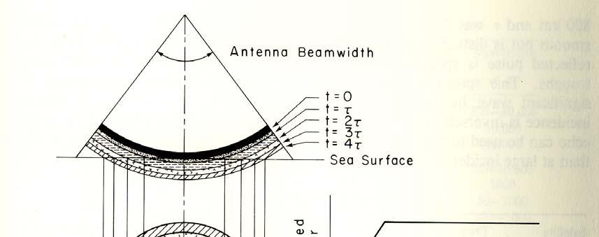
29 Sea state affects the radar reflection
30
31 Corrections that must be applied in the range calculation: (1) Sea state bias Electromagnetic bias difference between height of mean sea level and mean scattering surface backscatter from small wave facet is proportional to curvature of long wave part of spectrum ocean troughs have a larger radius of curvature than wave crests greater reflection from wave troughs than wave crests induces an EM sea level bias toward wave troughs Skewness bias non-gaussian distribution of the sea surface height shifts the median from the mean sea level toward wave troughs adding to the EM bias towards wave troughs Where is Jason now?
32 Corrections that must be applied in the range calculation: (2) Index of refraction (speed of light through atmosphere) Ionospheric correction variation in the number of free electrons present in the sub-satellite ionosphere electron content varies from day to night (few free electrons at night), from summer to winter (fewer during summer), and as a function of the solar cycle (fewer during the solar minimum) Tropospheric correction water vapor and other gases present in the subsatellite troposhere the dry troposphere correction can be modeled via surface pressure measurements the wet correction uses measurements from an onboard radiometer the dry term includes the weight of the water molecules while the wet term accounts for their influence on the index of refraction.

33 Where is Jason now?

34 Applications
35 Applications

36 Future of Altimetry Cryosat (ESA) Altimeter dedicated to polar observation High inclination orbit 92 o, 710 km altitude 3½ -year mission to determine variations in the thickness of the continental ice sheets and marine ice cover Test the predictions of thinning arctic ice due to global warming Low resolution nadir altimeter can operate in SAR mode Launch July 2005 Where is Jason now?
37 Future of Altimetry WSOA: the Wide Swath Ocean Altimeter An altimeter/interferometer project Several altimeters mounted on masts will acquire measurements simultaneously, providing continuous wide-area coverage. WSOA is based on a technique combining altimeter and interferometer measurements. It is a wide-field radar altimeter able to measure seasurface height across a swath centered on the satellite ground track. The satellite payload will include: dual-frequency, nadir-looking radar altimeter in Ku and C bands to provide ionospheric corrections acquire measurements as accurate as Topex and the Jason A three-channel radiometer GPS, Doris and laser reflector precise orbit determination WSOA, comprising two interferometers mounted on a mast, with a baseline of 6.4 m each covering a swath of 15 to 100 km Where is Jason now?

38 WSOA on Jason-2 Three factors underlying measurement uncertainty: Measurement noise, which depends on the antenna baseline (longer baseline = less noise). With an antenna baseline of 6.4 m the raw noise is 5.2 cm Ionospheric, tropospheric and sea-state bias effects (estimated at 1 to 2 cm) Errors from satellite roll and pitch steering which impact measurement geometry

39 Comparison of T/P+Jason-1 measurements and simulated WSOA data (with Topex/Poseidon shifted into an orbit parallel to Jason-1). This mosaic offers a huge advantage in terms of describing the dynamic topography at high resolution: It allows a measure of sea surface gradient between pixels and, therefore, geostrophic velocity Simulations based on realistic model data yield an error of 4.7 cm/s rms on the zonal velocity and 5.9 cm/s on meridional velocity.
Remote Sensing: John Wilkin IMCS Building Room 211C ext 251. Active microwave systems (1) Satellite Altimetry
 Satellite Altimetry") Remote Sensing: John Wilkin wilkin@marine.rutgers.edu IMCS Building Room 211C 732-932-6555 ext 251 Active microwave systems (1) Satellite Altimetry Active microwave instruments Scatterometer (scattering
Remote Sensing: John Wilkin wilkin@marine.rutgers.edu IMCS Building Room 211C 732-932-6555 ext 251 Active microwave systems (1) Satellite Altimetry Active microwave instruments Scatterometer (scattering
Active microwave systems (1) Satellite Altimetry
 Satellite Altimetry") Remote Sensing: John Wilkin Active microwave systems (1) Satellite Altimetry jwilkin@rutgers.edu IMCS Building Room 214C 732-932-6555 ext 251 Active microwave instruments Scatterometer (scattering from
Remote Sensing: John Wilkin Active microwave systems (1) Satellite Altimetry jwilkin@rutgers.edu IMCS Building Room 214C 732-932-6555 ext 251 Active microwave instruments Scatterometer (scattering from
Active microwave systems (2) Satellite Altimetry * range data processing * applications
 Satellite Altimetry * range data processing * applications") Remote Sensing: John Wilkin wilkin@marine.rutgers.edu IMCS Building Room 211C 732-932-6555 ext 251 Active microwave systems (2) Satellite Altimetry * range data processing * applications Satellite Altimeters
Remote Sensing: John Wilkin wilkin@marine.rutgers.edu IMCS Building Room 211C 732-932-6555 ext 251 Active microwave systems (2) Satellite Altimetry * range data processing * applications Satellite Altimeters
Remote sensing of the oceans Active sensing
 Remote sensing of the oceans Active sensing Gravity Sea level Ocean tides Low frequency motion Scatterometry SAR http://daac.gsfc.nasa.gov/campaign_docs/ocdst/what_is_ocean_color.html Shape of the earth
Altimeter Range Corrections
 Altimeter Range Corrections Schematic Summary Corrections Altimeters Range Corrections Altimeter range corrections can be grouped as follows: Atmospheric Refraction Corrections Sea-State Bias Corrections
SATELLITE OCEANOGRAPHY
 SATELLITE OCEANOGRAPHY An Introduction for Oceanographers and Remote-sensing Scientists I. S. Robinson Lecturer in Physical Oceanography Department of Oceanography University of Southampton JOHN WILEY
A short course on Altimetry
 1 A short course on Altimetry Paolo Cipollini 1, Helen Snaith 2 1 National Oceanography Centre, Southampton, U.K. 2 British Oceanographic Data Centre, Southampton, U.K. with contributions by Peter Challenor,
ELECTROMAGNETIC PROPAGATION (ALT, TEC)
") ELECTROMAGNETIC PROPAGATION (ALT, TEC) N. Picot CNES, 18 Av Ed Belin, 31401 Toulouse, France Email : Nicolas.Picot@cnes.fr ABSTRACT For electromagnetic propagation, the ionosphere plays a key role. This
ELECTROMAGNETIC PROPAGATION (ALT, TEC) N. Picot CNES, 18 Av Ed Belin, 31401 Toulouse, France Email : Nicolas.Picot@cnes.fr ABSTRACT For electromagnetic propagation, the ionosphere plays a key role. This
Microwave Remote Sensing (1)
") Microwave Remote Sensing (1) Microwave sensing encompasses both active and passive forms of remote sensing. The microwave portion of the spectrum covers the range from approximately 1cm to 1m in wavelength.
Microwave Remote Sensing (1) Microwave sensing encompasses both active and passive forms of remote sensing. The microwave portion of the spectrum covers the range from approximately 1cm to 1m in wavelength.
Microwave Remote Sensing
 Provide copy on a CD of the UCAR multi-media tutorial to all in class. Assign Ch-7 and Ch-9 (for two weeks) as reading material for this class. HW#4 (Due in two weeks) Problems 1,2,3 and 4 (Chapter 7)
Copernicus Introduction Lisbon, Portugal 13 th & 14 th February 2014
 Copernicus Introduction Lisbon, Portugal 13 th & 14 th February 2014 Contents Introduction GMES Copernicus Six thematic areas Infrastructure Space data An introduction to Remote Sensing In-situ data Applications
INTERDISCIPLINARY SCIENCE AND APPLICATIONS USING SATELLITE RADAR ALTIMETRY
 NASA NASA ESA ESA JAXA NAS A INTERDISCIPLINARY SCIENCE AND APPLICATIONS USING SATELLITE RADAR ALTIMETRY C.K. SHUM EE Wave Propagation and Remote Sensing Joel Johnson November 14, 2012 Measurement Coverage:
The Delay-Doppler Altimeter
 Briefing for the Coastal Altimetry Workshop The Delay-Doppler Altimeter R. K. Raney Johns Hopkins University Applied Physics Laboratory 05-07 February 2008 1 What is a Delay-Doppler altimeter? Precision
CNES PRIORITIES IN POLAR AND CRYOSPHERE RESEARCH
 Polar Space Task Group 3rd Session CNES PRIORITIES IN POLAR AND CRYOSPHERE RESEARCH Juliette Lambin, Steven Hosford Wednesday, May 22th, 2013 Paris, France 1 OUTLINE CNES MISSIONS FOR POLAR/CRYOSPHERE
Passive Microwave Sensors LIDAR Remote Sensing Laser Altimetry. 28 April 2003
 Passive Microwave Sensors LIDAR Remote Sensing Laser Altimetry 28 April 2003 Outline Passive Microwave Radiometry Rayleigh-Jeans approximation Brightness temperature Emissivity and dielectric constant
Waveform Processing of Nadir-Looking Altimetry Data
 Waveform Processing of Nadir-Looking Altimetry Data Mònica Roca and Richard Francis ESA/ESTEC Noordwijk The Netherlands Contents 1. the concept 2. introduction 3. the on-board waveform [how the return
ESRIN-EOP-GMQ / IDEAS+ Version September Geophysical Corrections in Level 2 CryoSat Data Products
 ESRIN-EOP-GMQ / IDEAS+ Version 5.1 28 September 2016 Geophysical Corrections in Level 2 CryoSat Data Products Prepared by Erica Webb, Amanda Hall (IDEAS+, CryoSat QC Team) Checked by Jerome Bouffard (ESA,
GNSS Reflectometry and Passive Radar at DLR
 ACES and FUTURE GNSS-Based EARTH OBSERVATION and NAVIGATION 26./27. May 2008, TU München Dr. Thomas Börner, Microwaves and Radar Institute, DLR Overview GNSS Reflectometry a joined proposal of DLR and
MODULE 9 LECTURE NOTES 1 PASSIVE MICROWAVE REMOTE SENSING
 MODULE 9 LECTURE NOTES 1 PASSIVE MICROWAVE REMOTE SENSING 1. Introduction The microwave portion of the electromagnetic spectrum involves wavelengths within a range of 1 mm to 1 m. Microwaves possess all
Other Space Geodetic Techniques. E. Calais Purdue University - EAS Department Civil 3273
 Other Space Geodetic Techniques E. Calais Purdue University - EAS Department Civil 3273 ecalais@purdue.edu Satellite Laser Ranging = SLR Measurement of distance (=range) between a ground station and a
Introduction Active microwave Radar
 RADAR Imaging Introduction 2 Introduction Active microwave Radar Passive remote sensing systems record electromagnetic energy that was reflected or emitted from the surface of the Earth. There are also
Other Space Geodetic Techniques. E. Calais Purdue University - EAS Department Civil 3273
 Other Space Geodetic Techniques E. Calais Purdue University - EAS Department Civil 3273 ecalais@purdue.edu Satellite Laser Ranging Measurement of distance (=range) between a ground station and a satellite
RADIOMETRIC TRACKING. Space Navigation
 RADIOMETRIC TRACKING Space Navigation Space Navigation Elements SC orbit determination Knowledge and prediction of SC position & velocity SC flight path control Firing the attitude control thrusters to
RADIOMETRIC TRACKING. Space Navigation
 RADIOMETRIC TRACKING Space Navigation October 24, 2016 D. Kanipe Space Navigation Elements SC orbit determination Knowledge and prediction of SC position & velocity SC flight path control Firing the attitude
EE 529 Remote Sensing Techniques. Introduction
 EE 529 Remote Sensing Techniques Introduction Course Contents Radar Imaging Sensors Imaging Sensors Imaging Algorithms Imaging Algorithms Course Contents (Cont( Cont d) Simulated Raw Data y r Processing
THE NASA/JPL AIRBORNE SYNTHETIC APERTURE RADAR SYSTEM. Yunling Lou, Yunjin Kim, and Jakob van Zyl
 THE NASA/JPL AIRBORNE SYNTHETIC APERTURE RADAR SYSTEM Yunling Lou, Yunjin Kim, and Jakob van Zyl Jet Propulsion Laboratory California Institute of Technology 4800 Oak Grove Drive, MS 300-243 Pasadena,
Remote Sensing. Ch. 3 Microwaves (Part 1 of 2)
") Remote Sensing Ch. 3 Microwaves (Part 1 of 2) 3.1 Introduction 3.2 Radar Basics 3.3 Viewing Geometry and Spatial Resolution 3.4 Radar Image Distortions 3.1 Introduction Microwave (1cm to 1m in wavelength)
Remote Sensing Ch. 3 Microwaves (Part 1 of 2) 3.1 Introduction 3.2 Radar Basics 3.3 Viewing Geometry and Spatial Resolution 3.4 Radar Image Distortions 3.1 Introduction Microwave (1cm to 1m in wavelength)
Introduction to Microwave Remote Sensing
 Introduction to Microwave Remote Sensing lain H. Woodhouse The University of Edinburgh Scotland Taylor & Francis Taylor & Francis Group Boca Raton London New York A CRC title, part of the Taylor & Francis
UNIT Derive the fundamental equation for free space propagation?
 UNIT 8 1. Derive the fundamental equation for free space propagation? Fundamental Equation for Free Space Propagation Consider the transmitter power (P t ) radiated uniformly in all the directions (isotropic),
The Global Imager (GLI)
") The Global Imager (GLI) Launch : Dec.14, 2002 Initial check out : to Apr.14, 2003 (~L+4) First image: Jan.25, 2003 Second image: Feb.6 and 7, 2003 Calibration and validation : to Dec.14, 2003(~L+4) for
The Global Imager (GLI) Launch : Dec.14, 2002 Initial check out : to Apr.14, 2003 (~L+4) First image: Jan.25, 2003 Second image: Feb.6 and 7, 2003 Calibration and validation : to Dec.14, 2003(~L+4) for
Satellite Laser Retroreflectors for GNSS Satellites: ILRS Standard
 Satellite Laser Retroreflectors for GNSS Satellites: ILRS Standard Michael Pearlman Director Central Bureau International Laser Ranging Service Harvard-Smithsonian Center for Astrophysics Cambridge MA
Sea-state effects on Satellite Altimetry Overview of established models and recent developments
 Sea-state effects on Satellite Altimetry Overview of established models and recent developments Nelson PIRES 1*, Joana FERNANDES 1, Christine GOMMENGINGER 2 e Remko SCHARROO 3 1 DGAOT, Faculdade de Ciências,
MONITORING SEA LEVEL USING GPS
 38 MONITORING SEA LEVEL USING GPS Hasanuddin Z. Abidin* Abstract GPS (Global Positioning System) is a passive, all-weather satellite-based navigation and positioning system, which is designed to provide
OBSERVATION PERFORMANCE OF A PARIS ALTIMETER IN-ORBIT DEMONSTRATOR
 OBSERVATION PERFORMANCE OF A PARIS ALTIMETER IN-ORBIT DEMONSTRATOR Salvatore D Addio, Manuel Martin-Neira Acknowledgment to: Nicolas Floury, Roberto Pietro Cerdeira TEC-ETP, ETP, Electrical Engineering
Modelling GPS Observables for Time Transfer
 Modelling GPS Observables for Time Transfer Marek Ziebart Department of Geomatic Engineering University College London Presentation structure Overview of GPS Time frames in GPS Introduction to GPS observables
Concept Design of Space-Borne Radars for Tsunami Detection
 Concept Design of Space-Borne Radars for Tsunami Detection DLR German Aerospace Agency +Microwaves and Radar Institute *Remote Sensing Institute +Michele Galletti +Gerhard Krieger +Nicolas Marquart +Thomas
Monitoring the Earth Surface from space
 Monitoring the Earth Surface from space Picture of the surface from optical Imagery, i.e. obtained by telescopes or cameras operating in visual bandwith. Shape of the surface from radar imagery Surface
LE/ESSE Payload Design
 LE/ESSE4360 - Payload Design 3.2 Spacecraft Sensors Introduction to Sensors Earth, Moon, Mars, and Beyond Dr. Jinjun Shan, Professor of Space Engineering Department of Earth and Space Science and Engineering
RECOMMENDATION ITU-R S *
 Rec. ITU-R S.1339-1 1 RECOMMENDATION ITU-R S.1339-1* Rec. ITU-R S.1339-1 SHARING BETWEEN SPACEBORNE PASSIVE SENSORS OF THE EARTH EXPLORATION-SATELLITE SERVICE AND INTER-SATELLITE LINKS OF GEOSTATIONARY-SATELLITE
Sw earth Dw Direct wave GRw Ground reflected wave Sw Surface wave
 WAVE PROPAGATION By Marcel H. De Canck, ON5AU Electromagnetic radio waves can propagate in three different ways between the transmitter and the receiver. 1- Ground waves 2- Troposphere waves 3- Sky waves
RADAR (RAdio Detection And Ranging)
") RADAR (RAdio Detection And Ranging) CLASSIFICATION OF NONPHOTOGRAPHIC REMOTE SENSORS PASSIVE ACTIVE DIGITAL CAMERA THERMAL (e.g. TIMS) VIDEO CAMERA MULTI- SPECTRAL SCANNERS VISIBLE & NIR MICROWAVE Real
RADAR (RAdio Detection And Ranging) CLASSIFICATION OF NONPHOTOGRAPHIC REMOTE SENSORS PASSIVE ACTIVE DIGITAL CAMERA THERMAL (e.g. TIMS) VIDEO CAMERA MULTI- SPECTRAL SCANNERS VISIBLE & NIR MICROWAVE Real
Using the Radio Spectrum to Understand Space Weather
 Using the Radio Spectrum to Understand Space Weather Ray Greenwald Virginia Tech Topics to be Covered What is Space Weather? Origins and impacts Analogies with terrestrial weather Monitoring Space Weather
Microwave Sensors Subgroup (MSSG) Report
 Report") Microwave Sensors Subgroup (MSSG) Report Feb 17-20, 2014, ESA ESRIN, Frascati, Italy DONG, Xiaolong, MSSG Chair National Space Science Center Chinese Academy of Sciences (MiRS,NSSC,CAS) Email: dongxiaolong@mirslab.cn
Microwave Sensors Subgroup (MSSG) Report Feb 17-20, 2014, ESA ESRIN, Frascati, Italy DONG, Xiaolong, MSSG Chair National Space Science Center Chinese Academy of Sciences (MiRS,NSSC,CAS) Email: dongxiaolong@mirslab.cn
ATS 351 Lecture 9 Radar
 ATS 351 Lecture 9 Radar Radio Waves Electromagnetic Waves Consist of an electric field and a magnetic field Polarization: describes the orientation of the electric field. 1 Remote Sensing Passive vs Active
Active and Passive Microwave Remote Sensing
 Active and Passive Microwave Remote Sensing Passive remote sensing system record EMR that was reflected (e.g., blue, green, red, and near IR) or emitted (e.g., thermal IR) from the surface of the Earth.
2 INTRODUCTION TO GNSS REFLECTOMERY
 2 INTRODUCTION TO GNSS REFLECTOMERY 2.1 Introduction The use of Global Navigation Satellite Systems (GNSS) signals reflected by the sea surface for altimetry applications was first suggested by Martín-Neira
WorId Ocean Circulation Experiment
 WorId Ocean Circulation Experiment WOCE/NASA Altimeter Algorithm Workshop U.S. WOCE Technical Report Number 2 November, 1988 U.S. WOCE Science Steering Committee D. James Baker, Jr. (Joint Oceanographic
Ocean SAR altimetry. from SIRAL2 on CryoSat2 to Poseidon-4 on Jason-CS
 Ocean SAR altimetry from SIRAL2 on CryoSat2 to Poseidon-4 on Jason-CS Template reference : 100181670S-EN L. Phalippou, F. Demeestere SAR Altimetry EGM NOC, Southampton, 26 June 2013 History of SAR altimetry
Industry Day of the Copernicus Sentinel-5 and Jason-CS Projects
 Industry Day of the Copernicus Sentinel-5 and Jason-CS Projects With the present announcement, the European Space Agency and Astrium GmbH Satellites (Germany) inform the EMITS Users (European Companies
Acknowledgment. Process of Atmospheric Radiation. Atmospheric Transmittance. Microwaves used by Radar GMAT Principles of Remote Sensing
 GMAT 9600 Principles of Remote Sensing Week 4 Radar Background & Surface Interactions Acknowledgment Mike Chang Natural Resources Canada Process of Atmospheric Radiation Dr. Linlin Ge and Prof Bruce Forster
GNSS Ocean Reflected Signals
 GNSS Ocean Reflected Signals Per Høeg DTU Space Technical University of Denmark Content Experimental setup Instrument Measurements and observations Spectral characteristics, analysis and retrieval method
Synthetic aperture RADAR (SAR) principles/instruments October 31, 2018
 principles/instruments October 31, 2018") GEOL 1460/2461 Ramsey Introduction to Remote Sensing Fall, 2018 Synthetic aperture RADAR (SAR) principles/instruments October 31, 2018 I. Reminder: Upcoming Dates lab #2 reports due by the start of next
GEOL 1460/2461 Ramsey Introduction to Remote Sensing Fall, 2018 Synthetic aperture RADAR (SAR) principles/instruments October 31, 2018 I. Reminder: Upcoming Dates lab #2 reports due by the start of next
Sea state bias correction in coastal waters. D. Vandemark, S. LaBroue, R. Scharroo, V. Zlotnicki, H. Feng, N. Tran, B. Chapron, H.
 Sea state bias correction in coastal waters D. Vandemark, S. LaBroue, R. Scharroo, V. Zlotnicki, H. Feng, N. Tran, B. Chapron, H. Tolman 5-7 Feb. 2008 Coastal Altimetry Workshop 1 Overview of group consensus
Dr. Sandra L. Cruz Pol
 OUTLINE INTRODUCTION TO MICROWAVE REMOTE SENSING INEL 8695/6669 Dr. Sandra Cruz Pol Microwave Remote Sensing INEL 6669/8695 Dept. of Electrical & Computer Engineering, UPRM, Mayagüez, PR Importance of
Specificities of Near Nadir Ka-band Interferometric SAR Imagery
 Specificities of Near Nadir Ka-band Interferometric SAR Imagery Roger Fjørtoft, Alain Mallet, Nadine Pourthie, Jean-Marc Gaudin, Christine Lion Centre National d Etudes Spatiales (CNES), France Fifamé
NASDA S PRECISE ORBIT DETERMINATION SYSTEM
 NASDA S PRECISE ORBIT DETERMINATION SYSTEM Maki Maeda Takashi Uchimura, Akinobu Suzuki, Mikio Sawabe National Space Development Agency of Japan (NASDA) Sengen 2-1-1, Tsukuba, Ibaraki, 305-8505, JAPAN E-mail:
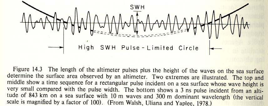
Sea Surface Backscatter Distortions of Scanning Radar Altimeter Ocean Wave Measurements
 Sea Surface Backscatter Distortions of Scanning Radar Altimeter Ocean Wave Measurements Edward J. Walsh and C. Wayne Wright NASA Goddard Space Flight Center Wallops Flight Facility Wallops Island, VA 23337
Sea Surface Temperature! Science Team!
 Science Team Introduction Sea Surface Temperature! Science Team! Eric Lindstrom NASA Science Mission Directorate Earth Science Division 8 November 2010 THANK YOU! To the Steering Team Andy Jessup & Peter
China. France Oceanography S A T. Overview of the near-real time wave products of the CFOSAT mission. e l l i t e
 China Overview of the near-real time wave products of the CFOSAT mission C. Tison (1), D. Hauser (2), S. Guibert (1), T. Amiot (1), L. Aouf (3), J.M. Lefèvre (3), B. Chapron (5), N. Corcoral (1), P. Castillan
A Permanent GPS Array in Crete & the Cal/Val facility for satellite radar altimeters in Gavdos
 A Permanent GPS Array in Crete & the Cal/Val facility for satellite radar altimeters in Gavdos S. P. Mertikas Technical University f Crete EUREF 2007 Symposium, 6-96 9 June 2007, London, England Laboratory
Remote Sensing 1 Principles of visible and radar remote sensing & sensors
 Remote Sensing 1 Principles of visible and radar remote sensing & sensors Nick Barrand School of Geography, Earth & Environmental Sciences University of Birmingham, UK Field glaciologist collecting data
SuperDARN (Super Dual Auroral Radar Network)
") SuperDARN (Super Dual Auroral Radar Network) What is it? How does it work? Judy Stephenson Sanae HF radar data manager, UKZN Ionospheric radars Incoherent Scatter radars AMISR Arecibo Observatory Sondrestrom
SuperDARN (Super Dual Auroral Radar Network) What is it? How does it work? Judy Stephenson Sanae HF radar data manager, UKZN Ionospheric radars Incoherent Scatter radars AMISR Arecibo Observatory Sondrestrom
Introduction to Radar
 National Aeronautics and Space Administration ARSET Applied Remote Sensing Training http://arset.gsfc.nasa.gov @NASAARSET Introduction to Radar Jul. 16, 2016 www.nasa.gov Objective The objective of this
Microwave Sensors Subgroup (MSSG) Report
 Report") Microwave Sensors Subgroup (MSSG) Report CEOS WGCV-35 May 13-17, 2013, Shanghai, China DONG, Xiaolong, MSSG Chair CAS Key Laboratory of Microwave Remote Sensing National Space Science Center Chinese Academy
Microwave Sensors Subgroup (MSSG) Report CEOS WGCV-35 May 13-17, 2013, Shanghai, China DONG, Xiaolong, MSSG Chair CAS Key Laboratory of Microwave Remote Sensing National Space Science Center Chinese Academy
Sub-Mesoscale Imaging of the Ionosphere with SMAP
 Sub-Mesoscale Imaging of the Ionosphere with SMAP Tony Freeman Xiaoqing Pi Xiaoyan Zhou CEOS Workshop, ASF, Fairbanks, Alaska, December 2009 1 Soil Moisture Active-Passive (SMAP) Overview Baseline Mission
Wide Swath Simultaneous Measurements of Winds and Ocean Surface Currents
 Wide Swath Simultaneous Measurements of Winds and Ocean Surface Currents Ernesto Rodriguez Jet Propulsion Laboratory California Institute of Technology 1 Thanks! The JPL DFS/ERM team for design of the
Scientific Applications of Fully-Focused SAR Altimetry
 Scientific Applications of Fully-Focused SAR Altimetry Alejandro Egido (1,2), Walter Smith (2) (1) UMD/CICS-MD, United States (2) NOAA, United States CICS Science Conference Nov 29, 30 & Dec 1, 2016 College
Dartmouth College SuperDARN Radars
 Dartmouth College SuperDARN Radars Under the guidance of Thayer School professor Simon Shepherd, a pair of backscatter radars were constructed in the desert of central Oregon over the Summer and Fall of
Active and Passive Microwave Remote Sensing
 Active and Passive Microwave Remote Sensing Passive remote sensing system record EMR that was reflected (e.g., blue, green, red, and near IR) or emitted (e.g., thermal IR) from the surface of the Earth.
Lecture 12: Curvature and Refraction Radar Equation for Point Targets (Rinehart Ch3-4)
") MET 4410 Remote Sensing: Radar and Satellite Meteorology MET 5412 Remote Sensing in Meteorology Lecture 12: Curvature and Refraction Radar Equation for Point Targets (Rinehart Ch3-4) Radar Wave Propagation
MET 4410 Remote Sensing: Radar and Satellite Meteorology MET 5412 Remote Sensing in Meteorology Lecture 12: Curvature and Refraction Radar Equation for Point Targets (Rinehart Ch3-4) Radar Wave Propagation
SCIRoCCo Scatterometry Glossary
 Scatterometry Prepared by: The Team: Change register Version/Rev. Date Reason for Change Changes 1.0 08/05/2014 First Release. Preliminary version 1.1 20/02/2015 4 th bi-monthly Report Review Contributions
UNERSITY OF NAIROBI UNIT: PRICIPLES AND APPLICATIONS OF REMOTE SENSING AND APLLIED CLIMATOLOGY
 UNERSITY OF NAIROBI DEPARTMENT OF METEOROLOGY UNIT: PRICIPLES AND APPLICATIONS OF REMOTE SENSING AND APLLIED CLIMATOLOGY COURSE CODE: SMR 308 GROUP TWO: SENSORS MEMBERS OF GROUP TWO 1. MUTISYA J.M I10/2784/2006
Improvement and Validation of Ranging Accuracy with YG-13A
 Article Improvement and Validation of Ranging Accuracy with YG-13A Mingjun Deng 1, Guo Zhang 2, *, Ruishan Zhao 3, Jiansong Li 1, Shaoning Li 2 1 School of Remote Sensing and Information Engineering, Wuhan
IAG School on Reference Systems June 7 June 12, 2010 Aegean University, Department of Geography Mytilene, Lesvos Island, Greece SCHOOL PROGRAM
 IAG School on Reference Systems June 7 June 12, 2010 Aegean University, Department of Geography Mytilene, Lesvos Island, Greece SCHOOL PROGRAM Monday June 7 8:00-9:00 Registration 9:00-10:00 Opening Session
Radar Reprinted from "Waves in Motion", McGourty and Rideout, RET 2005
 Radar Reprinted from "Waves in Motion", McGourty and Rideout, RET 2005 What is Radar? RADAR (Radio Detection And Ranging) is a way to detect and study far off targets by transmitting a radio pulse in the
Sea surface temperature observation through clouds by the Advanced Microwave Scanning Radiometer 2
 Sea surface temperature observation through clouds by the Advanced Microwave Scanning Radiometer 2 Akira Shibata Remote Sensing Technology Center of Japan (RESTEC) Tsukuba-Mitsui blds. 18F, 1-6-1 Takezono,
OVERVIEW OF THE ALOS SATELLITE SYSTEM
 OVERVIEW OF THE ALOS SATELLITE SYSTEM Presented to The Symposium for ALOS Data Application Users @Kogakuin University, Tokyo, Japan Mar. 27, 2001 Takashi Hamazaki Senior Engineer ALOS Project National
MWR and DORIS Supporting Envisat s Radar Altimetry Mission
 MWR and DORIS Supporting Envisat s Radar Altimetry Mission mwr and doris J. Guijarro (MWR) Envisat Project Division, ESA Directorate of Application Programmes. ESTEC, Noordwijk, The Netherlands A. Auriol,
Aquarius/SAC-D Mission Mission Simulators - Gary Lagerloef 6 th Science Meeting; Seattle, WA, USA July 2010
 Aquarius/SAC-D Mission Mission Simulators - Gary Lagerloef 6 th Science Meeting; Seattle, WA, USA Mission Design and Sampling Strategy Sun-synchronous exact repeat orbit 6pm ascending node Altitude 657
Fundamentals of GPS Navigation
 Fundamentals of GPS Navigation Kiril Alexiev 1 /76 2 /76 At the traditional January media briefing in Paris (January 18, 2017), European Space Agency (ESA) General Director Jan Woerner explained the knowns
remote sensing? What are the remote sensing principles behind these Definition
 Introduction to remote sensing: Content (1/2) Definition: photogrammetry and remote sensing (PRS) Radiation sources: solar radiation (passive optical RS) earth emission (passive microwave or thermal infrared
RADAR DEVELOPMENT BASIC CONCEPT OF RADAR WAS DEMONSTRATED BY HEINRICH. HERTZ VERIFIED THE MAXWELL RADAR.
 1 RADAR WHAT IS RADAR? RADAR (RADIO DETECTION AND RANGING) IS A WAY TO DETECT AND STUDY FAR OFF TARGETS BY TRANSMITTING A RADIO PULSE IN THE DIRECTION OF THE TARGET AND OBSERVING THE REFLECTION OF THE
Earth Remote Sensing using Surface-Reflected GNSS Signals (Part II)
") Jet Propulsion Laboratory California Institute of Technology National Aeronautics and Space Administration Jet Propulsion Laboratory California Institute of Technology Pasadena, California Earth Remote
Jet Propulsion Laboratory California Institute of Technology National Aeronautics and Space Administration Jet Propulsion Laboratory California Institute of Technology Pasadena, California Earth Remote
ACTIVE SENSORS RADAR
 ACTIVE SENSORS RADAR RADAR LiDAR: Light Detection And Ranging RADAR: RAdio Detection And Ranging SONAR: SOund Navigation And Ranging Used to image the ocean floor (produce bathymetic maps) and detect objects
Lecture Notes Prepared by Prof. J. Francis Spring Remote Sensing Instruments
 Lecture Notes Prepared by Prof. J. Francis Spring 2005 Remote Sensing Instruments Material from Remote Sensing Instrumentation in Weather Satellites: Systems, Data, and Environmental Applications by Rao,
New concepts for space-borne Tsunami early warning using microwave sensors
 GITEWS New concepts for space-borne Tsunami early warning using microwave sensors Dr. Thomas Börner Microwaves and Radar Institute (IHR) German Aerospace Center (DLR) Overview Conceiving and designing
Copyrighted Material. Contents
 Preface xiii 1 Introduction 1 1.1 Concepts 1 1.2 Spacecraft Sensors Cost 5 1.2.1 Introduction to Cost Estimating 5 1.2.2 Cost Data 7 1.2.3 Cost Estimating Methodologies 8 1.2.4 The Cost Estimating Relationship
Space Weather and the Ionosphere
 Dynamic Positioning Conference October 17-18, 2000 Sensors Space Weather and the Ionosphere Grant Marshall Trimble Navigation, Inc. Note: Use the Page Down key to view this presentation correctly Space
Geodetic Reference Frame Theory
 Technical Seminar Reference Frame in Practice, Geodetic Reference Frame Theory and the practical benefits of data sharing Geoffrey Blewitt University of Nevada, Reno, USA http://geodesy.unr.edu Sponsors:
SODAR- sonic detecting and ranging
 Active Remote Sensing of the PBL Immersed vs. remote sensors Active vs. passive sensors RADAR- radio detection and ranging WSR-88D TDWR wind profiler SODAR- sonic detecting and ranging minisodar RASS RADAR
Advanced Optical Satellite (ALOS-3) Overviews
 Overviews") K&C Science Team meeting #24 Tokyo, Japan, January 29-31, 2018 Advanced Optical Satellite (ALOS-3) Overviews January 30, 2018 Takeo Tadono 1, Hidenori Watarai 1, Ayano Oka 1, Yousei Mizukami 1, Junichi
K&C Science Team meeting #24 Tokyo, Japan, January 29-31, 2018 Advanced Optical Satellite (ALOS-3) Overviews January 30, 2018 Takeo Tadono 1, Hidenori Watarai 1, Ayano Oka 1, Yousei Mizukami 1, Junichi
STM Product Evolution for Processing Baseline 2.24
 PREPARATION AND OPERATIONS OF THE MISSION PERFORMANCE CENTRE (MPC) FOR THE COPERNICUS SENTINEL-3 MISSION Contract: 4000111836/14/I-LG Customer: ESA Document Contract No.: 4000111836/14/I-LG Project: PREPARATION
Study of small scale plasma irregularities. Đorđe Stevanović
 Study of small scale plasma irregularities in the ionosphere Đorđe Stevanović Overview 1. Global Navigation Satellite Systems 2. Space weather 3. Ionosphere and its effects 4. Case study a. Instruments
t =1 Transmitter #2 Figure 1-1 One Way Ranging Schematic
 1.0 Introduction OpenSource GPS is open source software that runs a GPS receiver based on the Zarlink GP2015 / GP2021 front end and digital processing chipset. It is a fully functional GPS receiver which
SYSTEM 5900 SIDE SCAN SONAR
 SYSTEM 5900 SIDE SCAN SONAR HIGH-RESOLUTION, DYNAMICALLY FOCUSED, MULTI-BEAM SIDE SCAN SONAR Klein Marine System s 5900 sonar is the flagship in our exclusive family of multi-beam technology-based side
Chapter 8. Remote sensing
 1. Remote sensing 8.1 Introduction 8.2 Remote sensing 8.3 Resolution 8.4 Landsat 8.5 Geostationary satellites GOES 8.1 Introduction What is remote sensing? One can describe remote sensing in different
The Ionosphere and Thermosphere: a Geospace Perspective
 The Ionosphere and Thermosphere: a Geospace Perspective John Foster, MIT Haystack Observatory CEDAR Student Workshop June 24, 2018 North America Introduction My Geospace Background (Who is the Lecturer?
10 Satellite-Based Remote Sensing
 10 Satellite-Based Remote Sensing 10.1 Introduction Those beginning to read the book at this chapter could find it troublesome with so many references to previous chapters, but it is the only way we found
746A27 Remote Sensing and GIS
 746A27 Remote Sensing and GIS Lecture 1 Concepts of remote sensing and Basic principle of Photogrammetry Chandan Roy Guest Lecturer Department of Computer and Information Science Linköping University What
GNSS Remote Sensing: CubeSat case study
 GNSS Remote Sensing: CubeSat case study P-GRESSION system and its background at PoliTo CubeSat Team Lorenzo Feruglio PhD student, Aerospace Engineering LIST OF ACRONYMS LIST OF FIGURES Introduction GNSS