ACTIVE MICROWAVE REMOTE SENSING OF LAND SURFACE HYDROLOGY
|
|
|
- Lesley Mason
- 5 years ago
- Views:
Transcription
1 Basics, methods & applications ACTIVE MICROWAVE REMOTE SENSING OF LAND SURFACE HYDROLOGY
2 Active microwave remote sensing of land surface hydrology Landsurface hydrology: Near surface water storage: soil, snow, water bodies Introduction Why microwave remote sensing? Why active?
3 Why microwave remote sensing Cloud independent Therefor frequent acquisitions possible, what is of interest when we study fast changes Complements optical and thermal For climate modelling interesting regional to global products available Aim Basic understanding on what radar based products can offer with respect to land surface hydrology
4 Why active systems (radar) Systems available which cover different scales and part of the electromagnetic spectrum Specific techniques available which offer unique insight into landsurface processes such as movements or surface structure Several relevant satellite launches in 2014 Sentinel-1 as part of copernicus is a radar system! + Future Biomass mission To some extent similar application potential like passive microwave sensors Annett.Bartsch@polarresearch.at
5 Basics Microwaves ~1cm 1m But (spaceborne) systems work on ~ 2-23cm Jensen 2005
6 Basics Wavelength Bands Polarization Single, dual, cross X C L Ku P S HH VV HV VH


7 Basics - Polarization Send Received HH or VV HV or VH Polarimetry analyses polarization state of an electromagnetic field


8 Basics - Polarization Cross polarisation modes detect the amount of backscatter whose polarisation has changed as a result of surface interaction Polarisation determines the penetration depth (beside the actual wavelength) HH VV HV colour composite
9 Basics X C L Ku P S Wavelength Bands Polarization Single, dual, cross Incidence angle Range Azimuth HH VV HV VH
 depression angle (γ) look angles (φ) incidence angle (Θ) Jensen,")
10 Terminology altitude above-groundlevel, H Nadir azimuth flight direction range (near and far) depression angle (γ) look angles (φ) incidence angle (Θ) Jensen, 2009
11 Basics Near range Backscatter local incidence angle far range Dense vegetation Bare dry soil Normalized measure of the radar return from a distributed target ESA Radar Glossary K u -Band; Stephen 2006

12 Basics Data are acquired At ascending and descending orbit, and in different modes vary in spatial resolution and area covered Example ENVISAT ASAR Right looking Varying length of frame Far range Near range


13 Basics preprocessing Normalization before normalization after normalization
14 Basics preprocessing Distortion phenomena Image distortion phenomena in side-looking radar imaging: (left) Foreshortening and (right) Layover & shadowing Rees 2001


15 Basics preprocessing Local Incidence Angle - LIA LIA for flat area LIA for Hochschwab, eastern Alps ENVISAT ASAR WS examples

 original")
16 Basics preprocessing Orthorectification of SAR terrain correction ENVISAT Synthetic Aperture Radar (SAR) original orthorectified Source: W. Wagner
17 Basics - SAR Pre-processing Radiometry and geometric distortions Orthorectification Normalization Speckle reduction Multilooking Adaptive filtering Speckle: caused by random constructive and destructive interference from the multiple scattering returns that will occur within each resolution cell
18 Basics X C L Ku P S Wavelength Bands Polarization Single, dual, cross Incidence angle Range Azimuth Beam A certain area on the surface is illuminated Spatial resolution? The product grid is nominal resolution HH VV HV VH
19 Basics spatial resolution (distance between distinguishable objects) Ground instantaneous field of view Footprint in case of non-imaging sensors range
20 Basics spatial resolution R a S L S - Slant range distance γ - Wavelength L - Antenna length range Resolution for real aperatures coarse from space! ½ of the pulse length

21 Basics spatial resolution Synthetic Aperture Radar Jensen, 2009
22 Basics instruments and applications real aperatures instruments scatterometer gridding required Used for global applications Frequent acquisitions Operational (designed for ocean applications)
23 Basics instruments and applications SAR synthetic aperture radar A technique to overcome the resolution problem, but local to regional applications Resolution azimuth and range difference Data availability a matter of request and priority

24 Currently in space, a selection Jensen 2005 ALOS2 PALSAR Sentinel 1, Radarsat, ASCAT TerraSAR-X

25 Currently in space, a selection Sentinel 1 (launched April 2014) Polarisation schemes for IW, EW & SM: single polarisation: HH or VV dual polarisation: HH+HV or VV+VH Wave mode: HH or VV SAR duty cycle per orbit: up to 25 min in any of the imaging modes up to 74 min in Wave mode Main modes of operations: - IW over land and coastal waters - EW over extended sea and sea-ice areas - WV over open oceans

26 Currently in space, a selection Sentinel 1 acquisition plan (selected modes)


27 Currently in space, a selection TerraSAR-X (since 2007) Acquisition plan


28 Currently in space, a selection ALOS-2 PALSAR (May 2014) Acquisition plan Wetlands & deforestation Crustal deformation
29 Past sensors - SAR Potential service demonstration Mid-term changes ENVISAT ASAR C-Band
30 Currently in space, a selection Scatterometer ASCAT on Metop A and B For meteorological purposes so continuation ensured Operational products, global C-band
31 Past sensor - scatterometer ERS1, ERS2 ( ) C-band Seawind on QuikScat ( ) Ku -band

32 Past sensor - scatterometer Examples 800 km 900 km Quelle: Perry 2000


33 km 900 km Daily coverage Perry 2000 Distribution of footprints and their time stamp Bartsch et al Naeimi 2010

34 BYU Images based on Eggs : 4.45 km Effective res km (source BYU)
35 Example Metop ASCAT Figa et al. 2002

36 Example Metop ASCAT ASCAT soil moisture product gridding Naeimi et al. 2009
37 Whats in space - soon SMAP soil moisture active passive currently planned for October, 2014 Frequency: 1.26 GHz Polarizations: VV, HH, HV (not fully polarimetric) Relative accuracy (3 km grid): 1 db (HH and VV), 1.5 db (HV) Data acquisition: High-resolution (SAR) data acquired over land Low-resolution data acquired globally NASA SMAP
38 NASA SMAP
39 Signal interaction Wavelength is very important Penetration depth into soil, snow, vegetation Change of direction Polarization is very important Penetration depth into especially vegetation (has a regular structure)
40 Signal interaction + Reflection enhanced when rel. permittivity (dielectric constant) and/or roughness is high
41 Signal interaction Examples C-Band (ASAR WS)

42 Signal interaction Examples C-Band ASCAT frozen/dry/inundated/melting snow Naeimi et al Saturated/ corner reflection
43 Signal interaction Winter Summer Volume scattering in vegetation Surface roughness Snow Near surface soil moisture
44 Daily air temperature range ERS C-band Seawinds QuikScat Ku-Band Bartsch, (2010)

45 Seawinds QuikScat - noise Bartsch 2010
46 Daily air temperature range ERS C-band Seawinds QuikScat Ku-Band Bartsch, (2010)
: Ten Years of SeaWinds on QuikSCAT for Snow Applications.")
47 Snowmelt QuikScat: Precise timing from diurnal difference Supplement to: Bartsch (2010): Ten Years of SeaWinds on QuikSCAT for Snow Applications. Remote Sensing, 2(4), , doi: /rs

48 Freeze/thaw Metop ASCAT
 ORCHIDEE-Land surface model")
49 Paulik et al. (2014) doi: /pangae A ( to ) ORCHIDEE-Land surface model Gouttevin et al. 2013
50 backscatter snow height Ulaby & Stiles 1980
51 Strong 140 W backscatter 150 W 170 W 180 increase 170 E 160 E 150 E in a few 140 E days 50 N 50 N Increase of snow depth in a very short time? (WMO512) 60 N 60 N 50 N average events per winter once twice three times four times more than four times 50 N 40 W 30 W 20 W 10 W 0 10 E 20 E 30 E 40 E Bartsch et al Bartsch (2010)

52 Snow profile taken on the 19th of November (Photo: Florian Stammler)


53 50 N 50 N 140 W 150 W 170 W E 160 E 150 E average events per winter once twice three times four times more than four times 40 W 30 W 20 W 10 W 0 10 E 20 E 30 E 140 E 40 E 50 N 60 N 60 N 50 N EO Summer School 2014 Rennert et al. 2009

54 number Size of events Median 470 km² Wilson, R.R., et al. 2013

55 Fog derived from NARR data Air temperature, due point, rel. humidity, visibility Semmens et al. (2013).
56 Wetland mapping Inundation permanent, seasonal Wet soils


57 Inundation mapping with SAR Specular Reflection over water Bartsch et al. (2008)

: Detection of open water")

58 West Siberien Lowlands Test with more than 4000 subsets of % Bartsch, A., Trofaier, A., Hayman, G., Sabel, D., Schlaffer, S., Clark D. & E. Blyth (2012): Detection of open water dynamics with ENVISAT ASAR in support of land surface modelling at high latitudes; Biogeosciences, 9,
59 Wetland areas Volume scattering in vegetation Surface roughness Double bounce urban (permanent phenomen) Near surface soil moisture Double bounce standing water (permanent and emerging vegetation) Mostly smooth water


60 Bartsch 2009 Okavango example end of rain season dry season

61 ESA STSE ALANIS Methane

62 ESA STSE ALANIS Methane experimental product from ENVISAT ASAR WS June 2007 September 2007

63 Example ENVISAT ASAR Wide swath Best available coverage among SAR sensors Actual coverage does however vary C-Band sensitivity to weather in case of this specific application Continuity with Sentinel 1 Bartsch et al., 2012

64 ESA STSE ALANIS Methane experimental product 10 days All summer including saturated area

: Capability of C-Band SAR for operational wetland")
65 ESA STSE ALANIS Methane experimental product Supplement to: Reschke, Julia; Bartsch, Annett; Schlaffer, Stefan; Schepaschenko, Dmitry (2012): Capability of C-Band SAR for operational wetland monitoring at high latitudes. Remote Sensing, 4(12), , doi: /rs
66 Signal interaction Volume scattering in vegetation Surface roughness Near surface soil moisture Two adjacent pixels, same total backscatter
67 Signal interaction How to separate those contributions Use a model Exploit different polarizations Combine with optical Rule out changes of certain mechanisms over time
68 Signal interaction Volume scattering in vegetation Surface roughness Near surface soil moisture
69 Soil moisture Time series for a single location (C-band) Wet reference Assumptions: - No rougness change - Vegetation impact can be modelled from incidence angle variation - References need to be known Dry reference Wagner et al. 1999
70 ASCAT
71 Basics Backscatter local incidence angle Dense vegetation Bare dry soil K u -Band; Stephen 2006
 Wet")

72 Soil moisture Time series for a single location (C-band) Wet reference Dry reference Wagner et al Bartsch et al. 2012
73 Soil moisture Penetration depth? Bartsch et al. 2012


74 Soil moisture But roughness change is possible In areas with high water fraction Change of scattering mechanism in part of the footprint flooding, freezing, snow Comparison with landsurface model ORCHIDEE, Gouttevin et al. 2013
75 Summary Soil moisture Footprint heterogeneity Weather impact! Snow Derived information: frozen/unfrozen Timing crucial (diurnal changes) Short wavelength required Inundantion Weather impact!
ACTIVE SENSORS RADAR
 ACTIVE SENSORS RADAR RADAR LiDAR: Light Detection And Ranging RADAR: RAdio Detection And Ranging SONAR: SOund Navigation And Ranging Used to image the ocean floor (produce bathymetic maps) and detect objects
Introduction to Radar
 National Aeronautics and Space Administration ARSET Applied Remote Sensing Training http://arset.gsfc.nasa.gov @NASAARSET Introduction to Radar Jul. 16, 2016 www.nasa.gov Objective The objective of this
Microwave Remote Sensing (1)
") Microwave Remote Sensing (1) Microwave sensing encompasses both active and passive forms of remote sensing. The microwave portion of the spectrum covers the range from approximately 1cm to 1m in wavelength.
Microwave Remote Sensing (1) Microwave sensing encompasses both active and passive forms of remote sensing. The microwave portion of the spectrum covers the range from approximately 1cm to 1m in wavelength.
Synthetic aperture RADAR (SAR) principles/instruments October 31, 2018
 principles/instruments October 31, 2018") GEOL 1460/2461 Ramsey Introduction to Remote Sensing Fall, 2018 Synthetic aperture RADAR (SAR) principles/instruments October 31, 2018 I. Reminder: Upcoming Dates lab #2 reports due by the start of next
GEOL 1460/2461 Ramsey Introduction to Remote Sensing Fall, 2018 Synthetic aperture RADAR (SAR) principles/instruments October 31, 2018 I. Reminder: Upcoming Dates lab #2 reports due by the start of next
Introduction Active microwave Radar
 RADAR Imaging Introduction 2 Introduction Active microwave Radar Passive remote sensing systems record electromagnetic energy that was reflected or emitted from the surface of the Earth. There are also
SAR Remote Sensing (Microwave Remote Sensing)
") iirs SAR Remote Sensing (Microwave Remote Sensing) Synthetic Aperture Radar Shashi Kumar shashi@iirs.gov.in Electromagnetic Radiation Electromagnetic radiation consists of an electrical field(e) which
iirs SAR Remote Sensing (Microwave Remote Sensing) Synthetic Aperture Radar Shashi Kumar shashi@iirs.gov.in Electromagnetic Radiation Electromagnetic radiation consists of an electrical field(e) which
CEGEG046 / GEOG3051 Principles & Practice of Remote Sensing (PPRS) 8: RADAR 1
 8: RADAR 1") CEGEG046 / GEOG3051 Principles & Practice of Remote Sensing (PPRS) 8: RADAR 1 Dr. Mathias (Mat) Disney UCL Geography Office: 113, Pearson Building Tel: 7670 05921 Email: mdisney@ucl.geog.ac.uk www.geog.ucl.ac.uk/~mdisney
CEGEG046 / GEOG3051 Principles & Practice of Remote Sensing (PPRS) 8: RADAR 1 Dr. Mathias (Mat) Disney UCL Geography Office: 113, Pearson Building Tel: 7670 05921 Email: mdisney@ucl.geog.ac.uk www.geog.ucl.ac.uk/~mdisney
Remote Sensing. Ch. 3 Microwaves (Part 1 of 2)
") Remote Sensing Ch. 3 Microwaves (Part 1 of 2) 3.1 Introduction 3.2 Radar Basics 3.3 Viewing Geometry and Spatial Resolution 3.4 Radar Image Distortions 3.1 Introduction Microwave (1cm to 1m in wavelength)
Remote Sensing Ch. 3 Microwaves (Part 1 of 2) 3.1 Introduction 3.2 Radar Basics 3.3 Viewing Geometry and Spatial Resolution 3.4 Radar Image Distortions 3.1 Introduction Microwave (1cm to 1m in wavelength)
Review. Guoqing Sun Department of Geography, University of Maryland ABrief
 Review Guoqing Sun Department of Geography, University of Maryland gsun@glue.umd.edu ABrief Introduction Scattering Mechanisms and Radar Image Characteristics Data Availability Example of Applications
RADAR REMOTE SENSING
 RADAR REMOTE SENSING Jan G.P.W. Clevers & Steven M. de Jong Chapter 8 of L&K 1 Wave theory for the EMS: Section 1.2 of L&K E = electrical field M = magnetic field c = speed of light : propagation direction
RADAR (RAdio Detection And Ranging)
") RADAR (RAdio Detection And Ranging) CLASSIFICATION OF NONPHOTOGRAPHIC REMOTE SENSORS PASSIVE ACTIVE DIGITAL CAMERA THERMAL (e.g. TIMS) VIDEO CAMERA MULTI- SPECTRAL SCANNERS VISIBLE & NIR MICROWAVE Real
RADAR (RAdio Detection And Ranging) CLASSIFICATION OF NONPHOTOGRAPHIC REMOTE SENSORS PASSIVE ACTIVE DIGITAL CAMERA THERMAL (e.g. TIMS) VIDEO CAMERA MULTI- SPECTRAL SCANNERS VISIBLE & NIR MICROWAVE Real
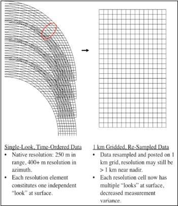
Specificities of Near Nadir Ka-band Interferometric SAR Imagery
 Specificities of Near Nadir Ka-band Interferometric SAR Imagery Roger Fjørtoft, Alain Mallet, Nadine Pourthie, Jean-Marc Gaudin, Christine Lion Centre National d Etudes Spatiales (CNES), France Fifamé
Towards Sentinel-1 Soil Moisture Data Services: The Approach taken by the Earth Observation Data Centre for Water Resources Monitoring
 Towards Sentinel-1 Soil Moisture Data Services: The Approach taken by the Earth Observation Data Centre for Water Resources Monitoring Wolfgang Wagner wolfgang.wagner@geo.tuwien.ac.at Department of Geodesy
Radar Imaging Wavelengths
 A Basic Introduction to Radar Remote Sensing ~~~~~~~~~~ Rev. Ronald J. Wasowski, C.S.C. Associate Professor of Environmental Science University of Portland Portland, Oregon 3 November 2015 Radar Imaging
Microwave Remote Sensing
 Provide copy on a CD of the UCAR multi-media tutorial to all in class. Assign Ch-7 and Ch-9 (for two weeks) as reading material for this class. HW#4 (Due in two weeks) Problems 1,2,3 and 4 (Chapter 7)
EE 529 Remote Sensing Techniques. Introduction
 EE 529 Remote Sensing Techniques Introduction Course Contents Radar Imaging Sensors Imaging Sensors Imaging Algorithms Imaging Algorithms Course Contents (Cont( Cont d) Simulated Raw Data y r Processing
SAR Remote Sensing. Introduction into SAR. Data characteristics, challenges, and applications.
 SAR Remote Sensing Introduction into SAR. Data characteristics, challenges, and applications. PD Dr. habil. Christian Thiel, Friedrich-Schiller-University Jena DLR-HR Jena & Friedrich-Schiller-University
MODULE 9 LECTURE NOTES 2 ACTIVE MICROWAVE REMOTE SENSING
 MODULE 9 LECTURE NOTES 2 ACTIVE MICROWAVE REMOTE SENSING 1. Introduction Satellite sensors are capable of actively emitting microwaves towards the earth s surface. An active microwave system transmits
Contribution of Sentinel-1 data for the monitoring of seasonal variations of the vegetation
 Contribution of Sentinel-1 data for the monitoring of seasonal variations of the vegetation P.-L. Frison, S. Kmiha, B. Fruneau, K. Soudani, E. Dufrêne, T. Koleck, L. Villard, M. Lepage, J.-F. Dejoux, J.-P.
Soil moisture retrieval using ALOS PALSAR
 Soil moisture retrieval using ALOS PALSAR T. J. Jackson, R. Bindlish and M. Cosh USDA ARS Hydrology and Remote Sensing Lab, Beltsville, MD J. Shi University of California Santa Barbara, CA November 6,
Synthetic Aperture Radar for Rapid Flood Extent Mapping
 National Aeronautics and Space Administration ARSET Applied Remote Sensing Training http://arset.gsfc.nasa.gov @NASAARSET Synthetic Aperture Radar for Rapid Flood Extent Mapping Sang-Ho Yun ARIA Team Jet
Towards Global Monitoring of Soil Moisture at 1 km Spatial Resolution using Sentinel-1: Initial Results
 Towards Global Monitoring of Soil Moisture at 1 km Spatial Resolution using Sentinel-1: Initial Results W. Wagner, V. Naeimi, B. Bauer-Marschallinger, S. Cao, A. Dostalova, C. Notarnicola, F. Greifeneder,
Introduction to RADAR Remote Sensing for Vegetation Mapping and Monitoring. Wayne Walker, Ph.D.
 Introduction to RADAR Remote Sensing for Vegetation Mapping and Monitoring Wayne Walker, Ph.D. Outline What is RADAR (and what does it measure)? RADAR as an active sensor Applications of RADAR to vegetation
The Sentinel-1 Constellation
 The Sentinel-1 Constellation Evert Attema, Sentinel-1 Mission & System Manager AGRISAR and EAGLE Campaigns Final Workshop 15-16 October 2007 ESA/ESTECNoordwijk, The Netherlands Sentinel-1 Programme Sentinel-1
Acknowledgment. Process of Atmospheric Radiation. Atmospheric Transmittance. Microwaves used by Radar GMAT Principles of Remote Sensing
 GMAT 9600 Principles of Remote Sensing Week 4 Radar Background & Surface Interactions Acknowledgment Mike Chang Natural Resources Canada Process of Atmospheric Radiation Dr. Linlin Ge and Prof Bruce Forster
The Global Imager (GLI)
") The Global Imager (GLI) Launch : Dec.14, 2002 Initial check out : to Apr.14, 2003 (~L+4) First image: Jan.25, 2003 Second image: Feb.6 and 7, 2003 Calibration and validation : to Dec.14, 2003(~L+4) for
The Global Imager (GLI) Launch : Dec.14, 2002 Initial check out : to Apr.14, 2003 (~L+4) First image: Jan.25, 2003 Second image: Feb.6 and 7, 2003 Calibration and validation : to Dec.14, 2003(~L+4) for
All rights reserved. ENVI, IDL and Jagwire are trademarks of Exelis, Inc. All other marks are the property of their respective owners.
 SAR Analysis Made Easy with SARscape 5.1 All rights reserved. ENVI, IDL and Jagwire are trademarks of Exelis, Inc. All other marks are the property of their respective owners. 2014, Exelis Visual Information
Active and Passive Microwave Remote Sensing
 Active and Passive Microwave Remote Sensing Passive remote sensing system record EMR that was reflected (e.g., blue, green, red, and near IR) or emitted (e.g., thermal IR) from the surface of the Earth.
ESA Radar Remote Sensing Course ESA Radar Remote Sensing Course Radar, SAR, InSAR; a first introduction
 Radar, SAR, InSAR; a first introduction Ramon Hanssen Delft University of Technology The Netherlands r.f.hanssen@tudelft.nl Charles University in Prague Contents Radar background and fundamentals Imaging
Copernicus Introduction Lisbon, Portugal 13 th & 14 th February 2014
 Copernicus Introduction Lisbon, Portugal 13 th & 14 th February 2014 Contents Introduction GMES Copernicus Six thematic areas Infrastructure Space data An introduction to Remote Sensing In-situ data Applications
Interpreting Digital RADAR Images
 R A D A R Introduction to Interpreting Digital Radar Images I N T E R P R E T Interpreting Digital RADAR Images with TNTmips page 1 Before Getting Started Airborne and satellite radar systems are versatile
Sentinel-1 Overview. Dr. Andrea Minchella
 Dr. Andrea Minchella 21-22/01/2016 ESA SNAP-Sentinel-1 Training Course Satellite Applications Catapult - Electron Building, Harwell, Oxfordshire Contents Sentinel-1 Mission Sentinel-1 SAR Modes Sentinel-1
Sub-Mesoscale Imaging of the Ionosphere with SMAP
 Sub-Mesoscale Imaging of the Ionosphere with SMAP Tony Freeman Xiaoqing Pi Xiaoyan Zhou CEOS Workshop, ASF, Fairbanks, Alaska, December 2009 1 Soil Moisture Active-Passive (SMAP) Overview Baseline Mission
Remote Sensing for Epidemiological Studies
 Remote Sensing for Epidemiological Studies Joint ICTP-IAEA Conference on Predicting Disease Patterns According to Climate Changes The Abdus Salam International Centre for Theoretical Physics 12-14 May
European Space Agency and IPY
 European Space Agency and IPY ESA supports IPY 2007-2008 activities: First ESA step was a dedicated Announcement Opportunity (AO) for EO data provision in support IPY, released in 2006, with data provision
10 Radar Imaging Radar Imaging
 10 Radar Imaging Active sensors provide their own source of energy to illuminate the target. Active sensors are generally divided into two distinct categories: imaging and non-imaging. The most common
Microwave remote sensing. Rudi Gens Alaska Satellite Facility Remote Sensing Support Center
 Microwave remote sensing Alaska Satellite Facility Remote Sensing Support Center 1 Remote Sensing Fundamental The entire range of EM radiation constitute the EM Spectrum SAR sensors sense electromagnetic
Remote sensing of the oceans Active sensing
 Remote sensing of the oceans Active sensing Gravity Sea level Ocean tides Low frequency motion Scatterometry SAR http://daac.gsfc.nasa.gov/campaign_docs/ocdst/what_is_ocean_color.html Shape of the earth
Imaging radar Imaging radars provide map-like coverage to one or both sides of the aircraft.
 CEE 6100 / CSS 6600 Remote Sensing Fundamentals 1 Imaging radar Imaging radars provide map-like coverage to one or both sides of the aircraft. Acronyms: RAR real aperture radar ("brute force", "incoherent")
SATELLITE OCEANOGRAPHY
 SATELLITE OCEANOGRAPHY An Introduction for Oceanographers and Remote-sensing Scientists I. S. Robinson Lecturer in Physical Oceanography Department of Oceanography University of Southampton JOHN WILEY
2010 International Ocean Vector Winds Meeting Barcelona, Spain, May A NASA Perspective: Present Status and Moving Forward
 2010 International Ocean Vector Winds Meeting Barcelona, Spain, 18-20 May 2010 A NASA Perspective: Present Status and Moving Forward Peter Hacker and Eric Lindstrom NASA Science Mission Directorate Earth
RADARSAT-2 Program Update Daniel De Lisle Canadian Space Agency
 RADARSAT-2 Program Update Daniel De Lisle Canadian Space Agency Presentation outline RADARSAT-1 Update RADARSAT-2 Mission description Mission Objectives System Characteristics Data Commercialization/Allocation
Observing Dry-Fallen Intertidal Flats in the German Bight Using ALOS PALSAR Together With Other Remote Sensing Sensors
 Observing Dry-Fallen Intertidal Flats in the German Bight Using ALOS PALSAR Together With Other Remote Sensing Sensors Martin Gade, Institut für Meereskunde & Kerstin Stelzer Brockmann Consult Outline
Sentinel-1 System Overview
 Sentinel-1 System Overview Dirk Geudtner, Rámon Torres, Paul Snoeij, Malcolm Davidson European Space Agency, ESTEC Global Monitoring for Environment and Security (GMES) EU-led program aiming at providing
School of Rural and Surveying Engineering National Technical University of Athens
 Laboratory of Photogrammetry National Technical University of Athens Combined use of spaceborne optical and SAR data Incompatible data sources or a useful procedure? Charalabos Ioannidis, Dimitra Vassilaki
Remote sensing radio applications/ systems for environmental monitoring
 Remote sensing radio applications/ systems for environmental monitoring Alexandre VASSILIEV ITU Radiocommunication Bureau phone: +41 22 7305924 e-mail: alexandre.vassiliev@itu.int 1 Source: European Space
Active and Passive Microwave Remote Sensing
 Active and Passive Microwave Remote Sensing Passive remote sensing system record EMR that was reflected (e.g., blue, green, red, and near IR) or emitted (e.g., thermal IR) from the surface of the Earth.
SAR IMAGE ANALYSIS FOR MICROWAVE C-BAND FINE QUAD POLARISED RADARSAT-2 USING DECOMPOSITION AND SPECKLE FILTER TECHNIQUE
 SAR IMAGE ANALYSIS FOR MICROWAVE C-BAND FINE QUAD POLARISED RADARSAT-2 USING DECOMPOSITION AND SPECKLE FILTER TECHNIQUE ABSTRACT Mudassar Shaikh Department of Electronics Science, New Arts, Commerce &
NON-PHOTOGRAPHIC SYSTEMS: Multispectral Scanners Medium and coarse resolution sensor comparisons: Landsat, SPOT, AVHRR and MODIS
 NON-PHOTOGRAPHIC SYSTEMS: Multispectral Scanners Medium and coarse resolution sensor comparisons: Landsat, SPOT, AVHRR and MODIS CLASSIFICATION OF NONPHOTOGRAPHIC REMOTE SENSORS PASSIVE ACTIVE DIGITAL
Status of Sentinel-1 and acquisition plans for GFOI
 Status of Sentinel-1 and acquisition plans for GFOI Frank Martin Seifert, Pierre Potin, Johannes Roeder, ESA Earth Observation Programme 5 th Space Data Coordination, ESRIN, Frascati, 24 February 2014
Description of the Instruments and Algorithm Approach
 Description of the Instruments and Algorithm Approach Passive and Active Remote Sensing SMAP uses active and passive sensors to measure soil moisture National Aeronautics and Space Administration Applied
Co-ReSyF RA lecture: Vessel detection and oil spill detection
 This project has received funding from the European Union s Horizon 2020 Research and Innovation Programme under grant agreement no 687289 Co-ReSyF RA lecture: Vessel detection and oil spill detection
Outline. Introduction. Introduction: Film Emulsions. Sensor Systems. Types of Remote Sensing. A/Prof Linlin Ge. Photographic systems (cf(
 GMAT x600 Remote Sensing / Earth Observation Types of Sensor Systems (1) Outline Image Sensor Systems (i) Line Scanning Sensor Systems (passive) (ii) Array Sensor Systems (passive) (iii) Antenna Radar
GMES Sentinel-1 Transponder Development
 GMES Sentinel-1 Transponder Development Paul Snoeij Evert Attema Björn Rommen Nicolas Floury Malcolm Davidson ESA/ESTEC, European Space Agency, Noordwijk, The Netherlands Outline 1. GMES Sentinel-1 overview
Remote Sensing 1 Principles of visible and radar remote sensing & sensors
 Remote Sensing 1 Principles of visible and radar remote sensing & sensors Nick Barrand School of Geography, Earth & Environmental Sciences University of Birmingham, UK Field glaciologist collecting data
SAR Multi-Temporal Applications
 SAR Multi-Temporal Applications 83230359-DOC-TAS-EN-001 Contents 2 Advantages of SAR Remote Sensing Technology All weather any time Frequencies and polarisations Interferometry and 3D mapping Change Detection
Application Potential of Planned SAR Satellites a Preview
 PREPRINT/PRÉTIRAGE Application Potential of Planned SAR Satellites a Preview J.J. van der Sanden 1, P. Budkewitsch 1, R. Landry 1, M.J. Manore 2, H. McNairn 1, T.J. Pultz 1, and P.W. Vachon 1 1 Canada
CNES PRIORITIES IN POLAR AND CRYOSPHERE RESEARCH
 Polar Space Task Group 3rd Session CNES PRIORITIES IN POLAR AND CRYOSPHERE RESEARCH Juliette Lambin, Steven Hosford Wednesday, May 22th, 2013 Paris, France 1 OUTLINE CNES MISSIONS FOR POLAR/CRYOSPHERE
Aquarius/SAC-D and Soil Moisture
 Aquarius/SAC-D and Soil Moisture T. J. Jackson P. O Neill February 24, 2011 Aquarius/SAC-D and Soil Moisture + L-band dual polarization + Combined active and passive Coarse spatial resolution (~100 km)
TerraSAR-X Image Product Guide
 [Texte] TerraSAR-X Image Product Guide Page 1 of 24 Ref.: OP00xxxxxxxxxx Commercial in Confidence 1 Introduction TerraSAR-X and TanDEM-X are commercial German Synthetic Aperture Radar (SAR) Earth observation
Calibration Assessment of RADARSAT-2 Polarimetry Using High Precision Transponders
 Calibration Assessment of RADARSAT-2 Polarimetry Using High Precision Transponders R Touzi, S Côté, RK Hawkins CCRS/CSA Acknowledgments S Nedelcu (CCRS) S Muir (CSA) 1 Outline-Polarimetric RADARSAT-2 Independent
remote sensing? What are the remote sensing principles behind these Definition
 Introduction to remote sensing: Content (1/2) Definition: photogrammetry and remote sensing (PRS) Radiation sources: solar radiation (passive optical RS) earth emission (passive microwave or thermal infrared
Use of Synthetic Aperture Radar images for Crisis Response and Management
 2012 IEEE Global Humanitarian Technology Conference Use of Synthetic Aperture Radar images for Crisis Response and Management Gerardo Di Martino, Antonio Iodice, Daniele Riccio, Giuseppe Ruello Department
Active microwave systems (1) Satellite Altimetry
 Satellite Altimetry") Remote Sensing: John Wilkin Active microwave systems (1) Satellite Altimetry jwilkin@rutgers.edu IMCS Building Room 214C 732-932-6555 ext 251 Active microwave instruments Scatterometer (scattering from
Remote Sensing: John Wilkin Active microwave systems (1) Satellite Altimetry jwilkin@rutgers.edu IMCS Building Room 214C 732-932-6555 ext 251 Active microwave instruments Scatterometer (scattering from
Passive Microwave Sensors LIDAR Remote Sensing Laser Altimetry. 28 April 2003
 Passive Microwave Sensors LIDAR Remote Sensing Laser Altimetry 28 April 2003 Outline Passive Microwave Radiometry Rayleigh-Jeans approximation Brightness temperature Emissivity and dielectric constant
SUGAR_GIS. From a user perspective. Provides spatial distribution of a wide range of sugarcane production data in an easy to use and sensitive way.
 SUGAR_GIS From a user perspective What is Sugar_GIS? A web-based, decision support tool. Provides spatial distribution of a wide range of sugarcane production data in an easy to use and sensitive way.
Polarisation Capabilities and Status of TerraSAR-X
 Polarisation Capabilities and Status of TerraSAR-X Irena Hajnsek, Josef Mittermayer, Stefan Buckreuss, Kostas Papathanassiou German Aerospace Center Microwaves and Radar Institute irena.hajnsek@dlr.de
Biomass, a polarimetric interferometric P-band SAR mission
 Biomass, a polarimetric interferometric P-band SAR mission M. Arcioni, P. Bensi, M. Fehringer, F. Fois, F. Heliere, N. Miranda, K. Scipal Fringe 2015, ESRIN 27/03/2015 The Biomass Mission 1. Biomass was
Data Requirements Definition and Data Services Options for RAPP
 Data Requirements Definition and Data Services Options for RAPP Brian Killough CEOS Systems Engineering Office (SEO) 5 th GEOGLAM RAPP Workshop Frascati, Italy May 16-17, 2017 Requirements Update The observation
SAR Training Course, MCST, Kalkara, Malta, November SAR Maritime Applications. History and Basics
 SAR Maritime Applications History and Basics Martin Gade Uni Hamburg, Institut für Meereskunde SAR Maritime Applications Thursday, 13 Nov.: 1 - History & Basics Introduction Radar/SAR History Basics Scatterometer
Introduction to Remote Sensing Fundamentals of Satellite Remote Sensing. Mads Olander Rasmussen
 Introduction to Remote Sensing Fundamentals of Satellite Remote Sensing Mads Olander Rasmussen (mora@dhi-gras.com) 01. Introduction to Remote Sensing DHI What is remote sensing? the art, science, and technology
Detection of a Point Target Movement with SAR Interferometry
 Journal of the Korean Society of Remote Sensing, Vol.16, No.4, 2000, pp.355~365 Detection of a Point Target Movement with SAR Interferometry Jung-Hee Jun* and Min-Ho Ka** Agency for Defence Development*,
Radar Polarimetry- Potential for Geosciences
 Radar Polarimetry- Potential for Geosciences Franziska Kersten Department of geology, TU Freiberg Abstract. The ability of Radar Polarimetry to obtain information about physical properties of the surface
SAR Imagery: Airborne or Spaceborne? Presenter: M. Lorraine Tighe PhD
 SAR Imagery: Airborne or Spaceborne? Presenter: M. Lorraine Tighe PhD Introduction The geospatial community has seen a plethora of spaceborne SAR imagery systems where there are now extensive archives
ALOS and PALSAR. Masanobu Shimada
 ALOS and PALSAR Masanobu Shimada Earth Observation Research Center, National Space Development Agency of Japan, Harumi 1-8-10, Harumi island triton square office tower X 22, Chuo-Ku, Tokyo-To, Japan, 104-6023,
Remote Sensing: John Wilkin IMCS Building Room 211C ext 251. Active microwave systems (1) Satellite Altimetry
 Satellite Altimetry") Remote Sensing: John Wilkin wilkin@marine.rutgers.edu IMCS Building Room 211C 732-932-6555 ext 251 Active microwave systems (1) Satellite Altimetry Active microwave instruments Scatterometer (scattering
Remote Sensing: John Wilkin wilkin@marine.rutgers.edu IMCS Building Room 211C 732-932-6555 ext 251 Active microwave systems (1) Satellite Altimetry Active microwave instruments Scatterometer (scattering
An Introduction to Remote Sensing & GIS. Introduction
 An Introduction to Remote Sensing & GIS Introduction Remote sensing is the measurement of object properties on Earth s surface using data acquired from aircraft and satellites. It attempts to measure something
Introduction to Imaging Radar INF-GEO 4310
 Introduction to Imaging Radar INF-GEO 4310 22.9.2011 Literature Contact: yoann.paichard@ffi.no Suggested readings: Fundamentals of Radar Signal Processing, M.A. Richards, McGraw-Hill, 2005 High Resolution
Sentinel-1 Calibration and Performance
 Sentinel-1 Calibration and Performance Paul Snoeij Evert Attema Björn Rommen Nicolas Floury Berthyl Duesmann Malcolm Davidson Ramon Torres European Space Agency Sentinel-1 Mission Objectives Component
Calibration of RapidScat Instrument Drift. F. Dayton Minor
 Calibration of RapidScat Instrument Drift F. Dayton Minor A thesis submitted to the faculty of Brigham Young University in partial fulfillment of the requirements for the degree of Master of Science David
Remote Sensing: John Wilkin IMCS Building Room 211C ext 251. Active microwave systems (1) Satellite Altimetry
 Satellite Altimetry") Remote Sensing: John Wilkin wilkin@marine.rutgers.edu IMCS Building Room 211C 732-932-6555 ext 251 Active microwave systems (1) Satellite Altimetry Active microwave instruments Scatterometer (scattering
Remote Sensing: John Wilkin wilkin@marine.rutgers.edu IMCS Building Room 211C 732-932-6555 ext 251 Active microwave systems (1) Satellite Altimetry Active microwave instruments Scatterometer (scattering
Rec. ITU-R P RECOMMENDATION ITU-R P *
 Rec. ITU-R P.682-1 1 RECOMMENDATION ITU-R P.682-1 * PROPAGATION DATA REQUIRED FOR THE DESIGN OF EARTH-SPACE AERONAUTICAL MOBILE TELECOMMUNICATION SYSTEMS (Question ITU-R 207/3) Rec. 682-1 (1990-1992) The
A Coherent Bistatic Vegetation Model for SoOp Land Applications: Preliminary Simulation Results
 A Coherent Bistatic Vegetation Model for SoOp Land Applications: Preliminary Simulation Results Mehmet Kurum (1), Manohar Deshpande (2), Alicia T. Joseph (2), Peggy E. O Neill (2), Roger H. Lang (3), Orhan
Affordable space based radar for homeland security
 Changing the economics of space Affordable space based radar for homeland security Adam Baker Brent Abbott Phil Whittaker Rachel Bird Luis Gomes Summary Why Radar? However: Radar data is expensive Users
Int n r t o r d o u d c u ti t on o n to t o Remote Sensing
 Introduction to Remote Sensing Definition of Remote Sensing Remote sensing refers to the activities of recording/observing/perceiving(sensing)objects or events at far away (remote) places. In remote sensing,
IMPACT OF BAQ LEVEL ON INSAR PERFORMANCE OF RADARSAT-2 EXTENDED SWATH BEAM MODES
 IMPACT OF BAQ LEVEL ON INSAR PERFORMANCE OF RADARSAT-2 EXTENDED SWATH BEAM MODES Jayson Eppler (1), Mike Kubanski (1) (1) MDA Systems Ltd., 13800 Commerce Parkway, Richmond, British Columbia, Canada, V6V
Change detection in cultural landscapes
 9-11 November 2015 ESA-ESRIN, Frascati (Rome), Italy 3 rd ESA-EARSeL Course on Remote Sensing for Archaeology Day 3 Change detection in cultural landscapes DeodatoTapete (1,2) & Francesca Cigna (1,2) (1)
New capabilities in Earth Observation for agriculture
 New capabilities in Earth Observation for agriculture Prof. Katarzyna Dabrowska-Zielinska Head of Remote Sensing Department Institute of Geodesy and Cartography Modzelewskiego 27 Street 02-679 Warsaw Poland
KONGSBERG SATELLITE SERVICES 2017 Line Steinbakk, Director Programs. Himmel og hav - Ålesund 3. Oktober 2017
 KONGSBERG SATELLITE SERVICES 2017 Line Steinbakk, Director Programs Himmel og hav - Ålesund 3. Oktober 2017 KSAT HQ IN TROMSØ 69N Established in 1967 Kongsberg Satellite Services since 2002 World leading
Synthetic Aperture Radar
 Synthetic Aperture Radar Picture 1: Radar silhouette of a ship, produced with the ISAR-Processor of the Ocean Master A Synthetic Aperture Radar (SAR), or SAR, is a coherent mostly airborne or spaceborne
Fundamentals of Remote Sensing
 Climate Variability, Hydrology, and Flooding Fundamentals of Remote Sensing May 19-22, 2015 GEO-Latin American & Caribbean Water Cycle Capacity Building Workshop Cartagena, Colombia 1 Objective To provide
SARscape Modules for ENVI
 Visual Information Solutions SARscape Modules for ENVI Read, process, analyze, and output products from SAR data. ENVI. Easy to Use Tools. Proven Functionality. Fast Results. DEM, based on TerraSAR-X-1
SCIRoCCo Scatterometry Glossary
 Scatterometry Prepared by: The Team: Change register Version/Rev. Date Reason for Change Changes 1.0 08/05/2014 First Release. Preliminary version 1.1 20/02/2015 4 th bi-monthly Report Review Contributions
MODULE 9 LECTURE NOTES 1 PASSIVE MICROWAVE REMOTE SENSING
 MODULE 9 LECTURE NOTES 1 PASSIVE MICROWAVE REMOTE SENSING 1. Introduction The microwave portion of the electromagnetic spectrum involves wavelengths within a range of 1 mm to 1 m. Microwaves possess all
The Biomass Mission, status of the satellite system
 The Biomass Mission, status of the satellite system M. Arcioni, P. Bensi, M. Fehringer, F. Fois, F. Heliere, K. Scipal PolInSAR/Biomass Meeting 2015, ESRIN 29/01/2015 1. Key facts (lifetime, duty cycle
COMPARATIVE ANALYSIS OF INSAR DIGITAL SURFACE MODELS FOR TEST AREA BUCHAREST
 COMPARATIVE ANALYSIS OF INSAR DIGITAL SURFACE MODELS FOR TEST AREA BUCHAREST Iulia Dana (1), Valentin Poncos (2), Delia Teleaga (2) (1) Romanian Space Agency, 21-25 Mendeleev Street, 010362, Bucharest,
Remote Sensing for Resource Management
 Remote Sensing for Resource Management Ebenezer Nyadjro US Naval Research Lab/UNO RMU Summer Program (July 31-AUG 4, 2017) Motivation Polluted Pra River Motivation. 3 Motivation Polluted Pra River Motivation.
SAR Interferometry Capabilities of Canada's planned SAR Satellite Constellation
 SAR Interferometry Capabilities of Canada's planned SAR Satellite Constellation Dirk Geudtner, Guy Séguin,, Ralph Girard Canadian Space Agency RADARSAT Follow-on Program CSA is in the middle of a Phase
Global 25 m Resolution PALSAR-2/PALSAR Mosaic. and Forest/Non-Forest Map (FNF) Dataset Description
 Dataset Description") Global 25 m Resolution PALSAR-2/PALSAR Mosaic and Forest/Non-Forest Map (FNF) Dataset Description Japan Aerospace Exploration Agency (JAXA) Earth Observation Research Center (EORC) 1 Revision history Version
Global 25 m Resolution PALSAR-2/PALSAR Mosaic and Forest/Non-Forest Map (FNF) Dataset Description Japan Aerospace Exploration Agency (JAXA) Earth Observation Research Center (EORC) 1 Revision history Version
MULTI-TEMPORAL OBSERVATIONS OF SUGARCANE BY TERRASAR-X IMAGES
 MULTI-TEMPORAL OBSERVATIONS OF SUGARCANE BY TERRASAR-X IMAGES Nicolas BAGHDADI 1, Pierre TODOROFF 2, Thierry RABAUTE 3 and Claire TINEL 4 (1) CEMAGREF, UMR TETIS, 5 rue François Breton, 3493 Montpellier