Research Article GNSS-R Delay-Doppler Map Simulation Based on the 2004 Sumatra-Andaman Tsunami Event
|
|
|
- Elmer Shields
- 5 years ago
- Views:
Transcription
1 Journal of Sensors Volume 6, Article ID 786, pages Research Article GNSS-R Delay-Doppler Map Simulation Based on the Sumatra-Andaman Tsunami Event Qingyun Yan and Weimin Huang Faculty of Engineering and Applied Science, Memorial University, St. John s, NL, Canada AB X Correspondence should be addressed to Weimin Huang; weimin@mun.ca Received March ; Revised 9 June ; Accepted 9 June Academic Editor: Jose C. Nieto-Borge Copyright 6 Q. Yan and W. Huang. This is an open access article distributed under the Creative Commons Attribution License, which permits unrestricted use, distribution, and reproduction in any medium, provided the original work is properly cited. A new method for simulating Global Navigation Satellite System-Reflectometry (GNSS-R) delay-doppler maps (DDMs) of a tsunami-dominant sea surface is presented. In this method, the bistatic scattering Z-V model, the sea surface mean square slope model of Cox and Munk, and the tsunami-induced wind perturbation model are employed. The feasibility of the Cox and Munk model under a tsunami scenario is examined by comparing the Cox and Munk model based scattering coefficient with the Jason- measurement. A good consistency between these two results is obtained with a correlation coefficient of.9. After confirming the applicability of the Cox and Munk model for a tsunami-dominated sea, this study provides the simulations of the scattering coefficient distribution and the corresponding DDMs of a fixed region of interest before and during the tsunami. In the final analysis, by subtracting the simulation results that are free of tsunami from those with presence of tsunami, the tsunami-induced variations in scattering coefficients and DDMs can be clearly observed. As a result, the tsunami passage can be readily interpreted.. Introduction A tsunami is a special ocean event that manifests its characteristics in terms of high propagation speed in the deep sea and extremely high wave height nearshore. It has been widely recognized that tsunamis are one of the worst natural hazards. For example, the Sumatra-Andaman tsunami that occurred in claimed many lives and caused tremendous damage to several countries []. Therefore, tsunami detection is especially important. The conventional buoy measurement is a costly and inefficient method to detect tsunamis due to its high expense and low coverage []. The satellite altimeter may provide some direct information about the tsunami such as sea surface height (SSH) and the radar backscattering coefficient. For example, Jason- satellite altimeter encountered the Sumatra-Andaman tsunami on its path 9 for cycle 9, thereby offering valuable data on tsunami measurement []. However, only a handful of definitive SSH changes due to a tsunami event have been measured out of more than documented tsunami events since the launch of the TOPEX/Poseidon satellite altimeter in 99 []. This is mainly because of the limited coverage of the satellite altimeter []. Recently, GNSS-R emerged as an efficient and accurate technique for ocean remote sensing due to its advantages in temporal and spatial coverage and immunity to weather effects []. Those benefits of the application of GNSS-R may provide a promising solution to tsunami remote sensing. Moreover, manifestations of a tsunami in the deep ocean have been investigated by a large amount of researchers, thereby laying a theoretical foundation for the GNSS-R-based deep sea tsunami detection. In 996, tsunami-induced variations in sea surface roughness were first reported by Walker [] and were given the name tsunami shadow based on observations of the darkened stripes along the tsunami front. Later, Godin [6] explained that the tsunami-induced changes in sea surface roughness are due to the tsunami-induced perturbations in sea surface wind speed. Based on these results, a theoretical model for the calculation of tsunamiinducedseasurfacewindvelocityhasbeendevelopedin[]. In addition, recent research has made significant development on GNSS-R DDM-based sea surface wind remote sensing (e.g., [7 9]). These works have also contributed to the DDM simulation in this paper for a tsunami-dominated
2 Journal of Sensors sea surface, which is based upon the tsunami-perturbed sea surface wind speed. There are a few reports (e.g., [,, ]) in the literature about the GNSS-R altimetry-based tsunami detection. However, there is no publication on tsunami detection from GNSS-R DDM, to the authors knowledge. In this paper, a process for simulating tsunami-dominant seasurfaceddmisproposed.thismethodisbasedonthe Zavorotny and Voronovich (Z-V) bistatic scattering model [], the Cox and Munk sea surface mean square slope model [], and the tsunami-induced wind speed perturbation model []. Followed by the introduction to this method, the feasibility of the Cox and Munk model [] under a tsunami scenario is examined by comparing the simulated scattering coefficient with the Jason- measurement. After verifying its applicability, the tsunami DDM simulation can be achieved through inputting the background wind speed over the sea surfaceandthetsunami-inducedseasurfacechange.inthis work, the simulation results before and during a tsunami over a region of interest are presented. Through analysis, the passage of the tsunami over this region can be interpreted based on the observation of tsunami-induced variations in scattering coefficient and DDMs. This work may provide some new support for the GNSS-R DDM-based tsunami detection in the future. The remainder of this paper is organized as follows. The procedures of tsunami-dominant sea surface DDM simulation are described in Section. The verification of the Cox and Munk model under a tsunami scenario followed by the simulation results is presented in Section. Conclusions are presented in Section.. Model Implementation and Simulation Process The Cox and Munk model [] and the Z-V model [] have already been successfully applied to the GNSS-R DDMbased sea surface wind sensing (e.g., [7, ]). The Z-V model depicts the scattered GPS signal power as a function of time delay and Doppler frequency shift, the transmitter elevation angle, and the receiver height as well as the surface scattering coefficient (σ ). The Cox and Munk model substantiates an empirical relationship between the wind speed at the height of m above the sea surface (U )andtheseasurfacemean squareslope(mss).consequently,theseasurfacescattering coefficient is determined by MSS [7]. In summary, with knowledge of U the corresponding DDM can be simulated by combining the Cox and Munk model and the Z-V model. With this in mind, the associated DDM simulation can be completed if the distribution of U over a tsunami-dominant sea surface is available. The Z-V model [] can be described as follows: Y(τ,f D) =T i A D ( ρ)σ ( ρ)λ (τ) S(f D) πr R ( ρ)r T ( ρ) d ρ, where τ is the time delay between the received signal and the local code replica, Λ(τ) = τ/τ c,when τ c τ τ c ; () Λ=; otherwise τ c is the length of one code chip. Consider S(f D )=sin(πt i f D )/(πt i f D ), T i is the coherent integration time, ρ is the displacement vector of a surface point from the specular point (SP), D is the antenna radiation pattern, R T and R R are the distances from a point on the ocean surface to the GNSS-R transmitter and receiver, A represents the effective scattering surface area (glistening zone), and σ is the surface scattering coefficient. With the exception of σ, the rest of the terms in () are usually known for a specific GNSS system and its geometry. Therefore, we mainly consider the scattering coefficient σ, which may be written as [7] σ ( ρ) = π R P( q )( q ), () q z q z where R is the Fresnel reflection coefficient that depends on the local elevation angle, polarization, and the complex dielectric constant of sea water [7]; the scattering vector q canbeobtainedwiththelocationsofthetransmitter,receiver, and corresponding surface point; q /q z is the ocean surface slope, denoted hereafter as s. P(s) is the slope Probability Density Function (PDF) of the ocean surface gravity wave which is believed to be subject to Gaussian distribution with wind-dependent upwind variance σ u and crosswind variance σ c []. It is worth mentioning that tsunami waves are gravity waves. P(s) is expressed as [7] P (s) = π det (W) exp [ (s x ) s [ y W=[ cos φ sin φ ] [ σ u ] sin φ cos φ σ c [ cos φ sin φ sin φ cos φ ], T W ( s x )], s y ] where φ is the angle between the up-down wind direction and the x-axis. Subsequently, the clean sea surface mean squareslopemodelofcoxandmunk[]isintroducedto link the wind speed and wind direction to the upwind and crosswind variances, as where σ u =. (.6 f(u )), σ c =. (. +.9 U ), U U.9 { f(u )= 6 ln (U ).9 <U 6 { {. U U > 6. Following similar steps as presented in [7, ], the DDMs canbereadilysimulatedwiththeknowledgeofu,basedon thecoxandmunkmodel[]andthez-vmodel[]fora tsunami-free sea surface. () () ()
![Journal of Sensors For a tsunami-dominant sea surface, the effective wind speed can be derived from the tsunami-induced wind speed perturbation model [], that is, the so-called Godin model.](/docs-images/86/93460331/images/3-0.jpg "This model was proposed based on the observation data of tsunami shadow from the October, 99, Hokkaido tsunami [].")
3 Journal of Sensors For a tsunami-dominant sea surface, the effective wind speed can be derived from the tsunami-induced wind speed perturbation model [], that is, the so-called Godin model. This model was proposed based on the observation data of tsunami shadow from the October, 99, Hokkaido tsunami []. The theoretical derivation of this model and its validation based on simulation were presented in []. Moreover,thismodelhasbeensuccessfullyappliedinthe simulation of radar backscattering strength over a tsunami region (e.g., [, ]). The tsunami-induced variations in radar backscattering strength estimated based on the Godin model were consistent with the Jason- measurement []. Thus, the Godin model is employed here to determine the effective wind speed during a tsunami period. This model shows that the effective wind speed during a tsunami event depends on tsunami parameters and differs from the background wind speed by a factor of M [], and M= κac Hu ln β, (6) where κ =., u =.U, H is the height of the background logarithmic boundary layer, a is the sea surface height change due to tsunami, c= gd is the tsunami phase speed, where g istheaccelerationduetogravity,d is the depth of sea, and β= κu T πz, (7) where z =.u /g represents the roughness length and T is tsunami period. By employing these models, the tsunami DDMs can be simulated with different tsunami parameters and background wind speed.. Simulation Results In this section, feasibility of the Cox and Munk model under a tsunami scenario is tested first. Then, the parameters associated with tsunami DDM simulation are set. After that, the tsunami DDM simulation results are presented... Feasibility of the Cox and Munk Model under a Tsunami Scenario. The Jason- satellite altimeter encountered the tsunami on the morning of December 6, [] (shown in Figure ). It recorded radar backscattering coefficient and sea surface wind speed, thereby offering an opportunity to study the wind speed and σ during the tsunami event. Before exerting the tsunami DDM simulation, the feasibility of the Cox and Munk model under a tsunami event should be examined. By employing the Cox and Munk model, the σ of a tsunami-dominant sea surface can be simulated with the knowledge of U over the corresponding region. Based on this, a comparison between the Jason- measured σ and the simulated σ can be made. Figure illustrates the Jason- measured sea surface wind speeds (solid line) over the range of (6. S, 8.6 E) to (.99 N, 87. E) with the presence of the tsunami leading Latitude (deg) Jason- pass Longitude (deg) Figure : Jason- satellite altimeter ground track during the Sumatra-Andaman tsunami. Black line indicates the Jason- ground track with a direction in accordance with the arrow. White stars represent the epicentre. Contours of the tsunami leading front are also shown with hourly intervals. This graphic is modified from the work of the National Geophysical Data Center/NOAA, at 6.jpg. wave front. For the simulation, some assumptions are made below: () The GNSS-R transmitter, receiver, and the SP are set onthesamelinethatisalsoperpendiculartothesea surface. () The SP follows the Jason- ground track. () The Jason- measured U is uniform along tsunami wave front. The first assumption is required to simulate the Jason- backscattering scenario. The second assumes that the GNSS- R system and Jason- monitored this region at the same time. The last one aims at forming a two-dimensional wind speed distribution over the glistening zone. The size of GNSS-R glistening zone is about km by km. Through inputting the wind speeds that are interpolated using the Jason- measured U over sea surface, the scattering coefficient can therefore be simulated. Here, only the σ at SP which follows the Jason- ground track is recorded and compared with the Jason- measurements. Figure shows the σ measured by Jason- and the σ simulatedbythecoxandmunkmodel.agoodconsistency between the measured σ and the simulated σ can be observed with a correlation coefficient of.9. In Figure, the simulated scattering coefficients for GNSS-R seem to be slightly overestimated compared to the measurement by Jason-. This is mainly due to the difference in the operating frequencies of GNSS-R (. GHz, i.e., L-band) and Jason- (. GHz, i.e., C-band). The average difference of the scattering coefficient is about. db and this is consistent withtheanalysisin[6],wherethedifferenceofσ between
4 Journal of Sensors U (m/s) 6 Latitude (deg) Measured Modeled σ (db) 6 Latitude (deg) Measured Simulated SSH change (m) 6 Latitude (deg) Measured Fitted Figure:Jason-measurementforpass9from(6. S, 8.6 E) to (.99 N, 87. E) obtained during the tsunami: sea surface U, backscattering coefficient σ, and SSH change due to a tsunami. Gaps in the curves are caused by deficiency of measured data. L- and C-band measurements is found to be about db. Therefore, the feasibility of the Cox and Munk model on the tsunami DDM simulation is confirmed... Simulation Scenario Parameters. Basedontheanalysis above,itcanbeconcludedthattheσ of a tsunami-dominant sea surface can be simulated via the Cox and Munk model []. Thus, the tsunami DDMs can be simulated through the Z-V model [], the Cox and Munk model [], and the tsunami-induced wind speed perturbation model [] with reliability. Here, to facilitate the simulation, the typical empirical values are adopted in alignment with those in []; that is, T = min, D= m, and H=6 m. If the SSH change a due to tsunami and the background wind speed are known, the effective wind speed over a tsunami surface can therefore be determined by implementing the tsunami-induced wind speed perturbation model []. The SSH measured by Jason- on cycle 9 during the tsunami event is subtracted by the average SSH observed over the exactly same ground track on cycles 8 and, and the difference is regarded as tsunami-induced SSH change a (shown in Figure ). This process is in accord with [7]. Besides, it has been reported in [7] that the tsunamiinduced SSH change a over the range from (. S, 8.96 E) to (. N, 86. E)canbewellfittedbyasinewavewitha wavelength of 8 km and an amplitude of 6 cm, as shown by a dash line in Figure. Alternatively, the sine model is treatedas anotherform of inputa for reference. In addition, a is assumed to distribute uniformly along the contours of the tsunami leading wave front, which are concentric circles with a center at the epicenter (. N, 9. E). The U over the region under investigation measured by QuikSCAT on its orbit 87 is considered to be the background wind speed. The data was recorded around min before the earthquake appeared, which means this measurement is totally free of the tsunami influence. Therefore, it is reasonable to use the QuikSCAT measurement as the background U.TheeffectiveU is calculated using only the QuikSCAT measurement over the Jason- ground track and is shown in Figure. Difference between the modelled and measured wind speeds can be seen in Figure. This is because the modelled wind speed significantly relies on the background wind speed (i.e., before the appearance of tsunami). The only available background wind speed data of the region under investigation, immediately before the tsunami, was measured by QuikSCAT. However, the data was collected min before the earthquake happened. Moreover, Jason-flewoverthesameregionminaftertheearthquake appeared. Thus, a time gap of 6 min exists between the measured and the modelled wind speeds. As we know, wind speed may change significantly after two hours. This may explain the difference between the modelled and measured wind speeds. The parameters mentioned above are tabulated in Table. In terms of GNSS-R simulation scenario, the parameters are keptthesameasthosein[8],alsoshownintable. In order to manifest a unique influence of the tsunami on GNSS-R sea surface remote sensing in this work, a continuous detection over a fixed region is assumed. To achieve this, both the transmitter and the receiver are set fixed over time. In this fashion, the variations caused by the geometry change of GNSS-R system will be eliminated as well, which allows a more direct observation of tsunami effect. The region of our interest is set around (6.8 S, 8.69 E) with a size of kmbykm.thefirstsimulationresultwasconducted for :: UT. The study region at this time was tsunamifree. Therefore, this first simulation result is considered as


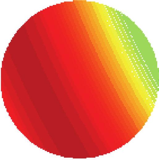


5 Journal of Sensors (f) Figure : Spatial distribution of tsunami-induced SSH change based on a sine wave model: before tsunami and with a part of tsunami leading front, the tsunami crest, a part between the crest and trough, the tsunami trough, and (f) the tail of tsunami leading front.


6 6 Journal of Sensors (f) Figure : Simulated σ using fitted sine wave as input: without tsunami and with a part of tsunami leading front; the tsunami crest; a part between the crest and trough; the tsunami trough; and (f) the tail of tsunami leading front.

7 Journal of Sensors (f) Figure : Corresponding DDMs resulting from σ in Figure. the initial baseline for the following results. Meanwhile, the SSH change in Figure is regarded as initial distribution. The initial simulation only depends on the background U over this region measured by QuikSCAT. However, within a few minutes, this region experienced a tsunami passage. The tsunami-induced wind speed perturbation model must be employed with the tsunami entering into this region. The effective U will be calculated based on this model with the knowledge of background U and a. As we have assumed D= m, the tsunami propagation speed can thus be approximated by m/s. Meanwhile, the initial distribution of a over space is known. For this reason, the a over this region at each moment can be easily deduced according to the distance and tsunami propagation speed. Then, the effective U at different time can also be determined... Results. The spatial distribution of tsunami-induced SSH change based on a sine wave model is shown in Figure. Figure displays the simulated σ by adopting the fitted sine wave model as input a. Thetimegapsbetween the initial detection in Figure and those from Figures


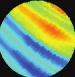
8 8 Journal of Sensors Figure 6: Differences of the scattering coefficients of tsunami-dominated and tsunami-free sea surfaces (based on sine wave-modelled SSH changes).
9 Journal of Sensors Figure 7: Differences of the DDMs of tsunami-dominated and tsunami-free sea surfaces (based on sine wave-modelled SSH changes).


10 Journal of Sensors (f) Figure 8: Spatial distribution of tsunami-induced SSH change based on Jason- measurements.


11 Journal of Sensors Figure 9: Differences of the scattering coefficients of tsunami-dominated and tsunami-free sea surfaces (based on Jason- measured SSH changes).


12 Journal of Sensors Figure : Differences of the DDMs of tsunami-dominated and tsunami-free sea surfaces (based on Jason- measured SSH changes).
13 Journal of Sensors Table : Tsunami DDM simulation setting up. Simulation parameters Tsunami period (T ) Depth of ocean (D) Height of the background logarithmic boundary layer (H) SSH change Background wind speed Receiver height Transmitter velocity Receiver velocity Value (data source) min m 6 m Jason- measurement/fitted sine wave model QuikSCAT measurement on orbit km (.7,.68,.6)km/s (7.,.,.7) km/s SP position (6.8 S, 8.69 E) to (f) are 9.7 min,.9 min, 6.67 min,. min, and 6.7 min, respectively. Figure shows the simulated DDMs corresponding to the scattering coefficient maps in Figure. In order to manifest the tsunami-induced variations in σ and DDMs, the simulation results with tsunami are subtracted by the initial result that contains no tsunami; that is, subplots (f) in both Figures and are subtracted by the corresponding subplot. The resultant scattering coefficient and DDM differences are displayed in Figures 6 and 7, respectively. Although the overall shapes in each subplot of Figure or Figure are similar, variations still can be observed. From Figure 6, the σ variations caused by the tsunami are found to be about ± db. This result is consistent with the analysis in []. Intuitively, an increase in a will lead to a reduction in M factor according to (6). On the other hand, a decrease in U will contribute to an increase in σ.onthewhole, the variations in σ are coincident with the changes of a. Therefore, the passage of the tsunami can be identified from Figure 6: the leading front appears first; then comes thecrest;thetransitionregionbetweenthecrestandthe trough approaches later; after that, the trough emerges; andfinally,thetsunamiwavepropagatesoutofthisregion with only a small portion of the tail remaining. The variations in σ are approximately proportional to the tsunami-induced SSH changes. The tsunami-induced variations in DDMs can be observed in Figure 7. The spatial distribution of tsunami-induced SSH change based on Jason- measurements is shown in Figure 8. Since the variations due to tsunami are not so obvious in simulated scattering coefficient maps and DDMs, only the differences between the results with and without tsunami are displayed in Figures 9-. Due to the non-ideal-sine distribution of measured a, these simulation results differ slightly from thosebasedonfittedsinewaveinputa. However,witha close observation of Figure 9, the variations in σ are also consistent with the distribution of measured a.. Conclusion In this work, a process is proposed to simulate the DDM of a tsunami-dominant sea surface. The Z-V model, the Cox and Munk model, and the tsunami-induced wind speed perturbation model are employed in this method. The feasibility of Cox and Munk model under the tsunami scenario is confirmed (a correlation coefficient of.9 between the simulated and measured σ is observed). After verifying the applicability of the Cox and Munk model for a tsunamidominated sea, σ andddmsaresimulatedwithtwodifferent tsunami-induced SSH change inputs, that is, Jason- measurement and fitted sine wave model. The σ variations causedbythetsunamiarefoundtobeabout±db, which is consistent with the result in []. Finally, by studying the tsunami-induced variations in σ, the passage of tsunami can be identified. In the future, tsunami parameters may be retrieved from the simulated DDMs of tsunami-dominant sea surface. It is also necessary to further validate the proposed method using collected GNSS-R data and corresponding measuredbackgroundandeffectivewindspeeddatasetduring a tsunami event. However, this study is not possible today as the available data for this research is limited. This may become possible with the launch of new spaceborne GNSS- R missions, for example, TechDemoSat- and Cyclone GNSS (CYGNSS) [9]. Conflict of Interests The authors declare that there is no conflict of interests regarding the publication of this paper. Acknowledgments This work was supported by the Natural Sciences and Engineering Research Council of Canada Discovery Grant (NSERC -) to Dr. Weimin Huang. The authors wouldliketothankc.arbourforhereditorialhelponthis paper. References [] K. Yu, Tsunami-wave parameter estimation using GNSSbased sea surface height measurement, IEEE Transactions on Geoscience and Remote Sensing, vol.,no.,pp.6 6,. [] O. A. Godin, V. G. Irisov, R. R. Leben, B. D. Hamlington, and G. A. Wick, Variations in sea surface roughness induced by the Sumatra-Andaman tsunami, Natural Hazards and Earth System Science,vol.9,no.,pp. 7,9. [] B. D. Hamlington, R. R. Leben, O. A. Godin, and V. G. Irisov, On the feasibility of tsunami detection using satellite-based sea surface roughness measurements, in Proceedings of the th IEEE International Geoscience and Remote Sensing Symposium (IGARSS ), pp. 8, Honolulu, Hawaii, USA, July. [] S. Jin, G. P. Feng, and S. Gleason, Remote sensing using GNSS signals: current status and future directions, Advances in Space Research,vol.7,no.,pp.6 6,. [] D. A. Walker, Observations of tsunami shadows : a new technique for assessing tsunami wave heights? Science of Tsunami Hazards,no.,pp.,996. [6] O. A. Godin, Air-sea interaction and feasibility of tsunami detection in the open ocean, JournalofGeophysicalResearch C: Oceans,vol.9,no.,ArticleIDC,pp.,.
14 Journal of Sensors [7] C. Li and W. Huang, An algorithm for sea-surface wind field retrieval from GNSS-R delay-doppler map, IEEE Geoscience and Remote Sensing Letters, vol., no., pp.,. [8] N. Rodriguez-Alvarez, D. M. Akos, V. U. Zavorotny, J. A. Smith, A. Camps, and C. W. Fairall, Airborne GNSS-R wind retrievals using delay-doppler maps, IEEE Transactions on Geoscience and Remote Sensing, vol., no., pp. 66 6,. [9] E. Valencia, V. U. Zavorotny, D. M. Akos, and A. Camps, Using DDM asymmetry metrics for wind direction retrieval from GPS ocean-scattered signals in airborne experiments, IEEE Transactions on Geoscience and Remote Sensing, vol.,no.7, pp. 9 96,. [] M. Martin-Neira, C. Buck, S. Gleason et al., Tsunami detection using the PARIS concept, in Proceedings of the Progress in Electromagnetics Research Symposium, Hangzhou, China, August. [] R. Stosius, G. Beyerle, A. Hoechner, J. Wickert, and J. Lauterjung, The impact on tsunami detection from space using GNSS-reflectometry when combining GPS with GLONASS and Galileo, Advances in Space Research,vol.7,no.,pp.8 8,. [] V. U. Zavorotny and A. G. Voronovich, Scattering of GPS signals from the ocean with wind remote sensing application, IEEE Transactions on Geoscience and Remote Sensing, vol.8, no., pp. 9 96,. [] C.CoxandW.Munk, Measurementoftheroughnessofthe sea surface from photographs of the sun s glitter, Journal of the Optical Society of America,vol.,no.,pp.88 8,9. []M.P.Clarizia,C.P.Gommenginger,S.T.Gleason,M.A. Srokosz, C. Galdi, and M. Di Bisceglie, Analysis of GNSS- R delay-doppler maps from the UK-DMC satellite over the ocean, Geophysical Research Letters, vol. 6, no., ArticleID L68, pages, 9. [] S. Gleason and D. Gebre-Egziabher, Remote sensing using bistatic GNSS reflections, in GNSS Applications and Methods, chapter 6, Artech House, 9. [6] A. Awada, A. Khenchaf, and A. Coatanhay, Frequency impact on the bistatic radar scattering from an ocean surface, in Proceedings of the IEEE International Geoscience and Remote Sensing Symposium (IGARSS 7), pp.9 6,Barcelona, Spain, June 7. [7] J. Gower, The 6 December tsunami measured by satellite altimetry, International Journal of Remote Sensing, vol.8,no. -, pp , 7. [8] C. Li, W. Huang, and S. Gleason, Dual antenna space-based GNSS-R ocean surface mapping: oil slick and tropical cyclone sensing, IEEE Journal of Selected Topics in Applied Earth Observations and Remote Sensing,vol.8,no.,pp.,. [9] C. Ruf, M. Unwin, J. Dickinson et al., CYGNSS: enabling the future of hurricane prediction [remote sensing satellites], IEEE Geoscience and Remote Sensing Magazine,vol.,no.,pp. 67,.


15 International Journal of Rotating Machinery Engineering Journal of Volume The Scientific World Journal Volume International Journal of Distributed Sensor Networks Journal of Sensors Volume Volume Volume Journal of Control Science and Engineering Advances in Civil Engineering Volume Volume Submit your manuscripts at Journal of Journal of Electrical and Computer Engineering Robotics Volume Volume VLSI Design Advances in OptoElectronics International Journal of Navigation and Observation Volume Chemical Engineering Volume Volume Active and Passive Electronic Components Antennas and Propagation Aerospace Engineering Volume Volume Volume International Journal of International Journal of International Journal of Modelling & Simulation in Engineering Volume Volume Shock and Vibration Volume Advances in Acoustics and Vibration Volume
Tsunami Simulation and Detection Using Global Navigation Satellite System Reflectometry
 Tsunami Simulation and Detection Using Global Navigation Satellite System Reflectometry by c Qingyun Yan, B.Eng. A thesis submitted to the School of Graduate Studies in partial fulfilment of the requirements
Research Article Modified Dual-Band Stacked Circularly Polarized Microstrip Antenna
 Antennas and Propagation Volume 13, Article ID 3898, pages http://dx.doi.org/1.11/13/3898 Research Article Modified Dual-Band Stacked Circularly Polarized Microstrip Antenna Guo Liu, Liang Xu, and Yi Wang
Earth Remote Sensing using Surface-Reflected GNSS Signals (Part II)
") Jet Propulsion Laboratory California Institute of Technology National Aeronautics and Space Administration Jet Propulsion Laboratory California Institute of Technology Pasadena, California Earth Remote
Jet Propulsion Laboratory California Institute of Technology National Aeronautics and Space Administration Jet Propulsion Laboratory California Institute of Technology Pasadena, California Earth Remote
On the Achievable Accuracy for Estimating the Ocean Surface Roughness using Multi-GPS Bistatic Radar
 On the Achievable Accuracy for Estimating the Ocean Surface Roughness using Multi-GPS Bistatic Radar Nima Alam, Kegen Yu, Andrew G. Dempster Australian Centre for Space Engineering Research (ACSER) University
Research Article Simulation and Performance Evaluations of the New GPS L5 and L1 Signals
 Hindawi Wireless Communications and Mobile Computing Volume 27, Article ID 749273, 4 pages https://doi.org/.55/27/749273 Research Article Simulation and Performance Evaluations of the New GPS and L Signals
2 INTRODUCTION TO GNSS REFLECTOMERY
 2 INTRODUCTION TO GNSS REFLECTOMERY 2.1 Introduction The use of Global Navigation Satellite Systems (GNSS) signals reflected by the sea surface for altimetry applications was first suggested by Martín-Neira
CYGNSS Wind Retrieval Performance
 International Ocean Vector Wind Science Team Meeting Kailua-Kona, Hawaii USA 6-8 May 2013 CYGNSS Wind Retrieval Performance Chris Ruf (1), Maria-Paola Clarizia (1,2), Andrew O Brien (3), Joel Johnson (3),
Research Article Miniaturized Circularly Polarized Microstrip RFID Antenna Using Fractal Metamaterial
 Antennas and Propagation Volume 3, Article ID 7357, pages http://dx.doi.org/.55/3/7357 Research Article Miniaturized Circularly Polarized Microstrip RFID Antenna Using Fractal Metamaterial Guo Liu, Liang
Research Article A Miniaturized Meandered Dipole UHF RFID Tag Antenna for Flexible Application
 Antennas and Propagation Volume 216, Article ID 2951659, 7 pages http://dx.doi.org/1.1155/216/2951659 Research Article A Miniaturized Meandered Dipole UHF RFID Tag Antenna for Flexible Application Xiuwei
Research Article A New Kind of Circular Polarization Leaky-Wave Antenna Based on Substrate Integrated Waveguide
 Antennas and Propagation Volume 1, Article ID 3979, pages http://dx.doi.org/1.11/1/3979 Research Article A New Kind of Circular Polarization Leaky-Wave Antenna Based on Substrate Integrated Waveguide Chong
Research Article Novel Design of Microstrip Antenna with Improved Bandwidth
 Microwave Science and Technology, Article ID 659592, 7 pages http://dx.doi.org/1.1155/214/659592 Research Article Novel Design of Microstrip Antenna with Improved Bandwidth Km. Kamakshi, Ashish Singh,
Remote Sensing with Reflected Signals
 Remote Sensing with Reflected Signals GNSS-R Data Processing Software and Test Analysis Dongkai Yang, Yanan Zhou, and Yan Wang (airplane) istockphoto.com/mark Evans; gpsiff background Authors from a leading
Research Article High Efficiency and Broadband Microstrip Leaky-Wave Antenna
 Active and Passive Electronic Components Volume 28, Article ID 42, pages doi:1./28/42 Research Article High Efficiency and Broadband Microstrip Leaky-Wave Antenna Onofrio Losito Department of Innovation
GNSS-Reflectometry for Observation and Monitoring of Earth surface
 GNSS-Reflectometry for Observation and Monitoring of Earth surface Global Navigation meets Geoinformation ESA ESOC Darmstadt, 28-04-2017 Dr. Ing. Domenico Schiavulli INR engineer support at EUMETSAT Outline
Research Article A Wide-Bandwidth Monopolar Patch Antenna with Dual-Ring Couplers
 Antennas and Propagation, Article ID 9812, 6 pages http://dx.doi.org/1.1155/214/9812 Research Article A Wide-Bandwidth Monopolar Patch Antenna with Dual-Ring Couplers Yuanyuan Zhang, 1,2 Juhua Liu, 1,2
Research Article Analysis and Design of Leaky-Wave Antenna with Low SLL Based on Half-Mode SIW Structure
 Antennas and Propagation Volume 215, Article ID 57693, 5 pages http://dx.doi.org/1.1155/215/57693 Research Article Analysis and Design of Leaky-Wave Antenna with Low SLL Based on Half-Mode SIW Structure
Theoretical Simulations of GNSS Reflections from Bare and Vegetated Soils
 Theoretical Simulations of GNSS Reflections from Bare and Vegetated Soils R. Giusto 1, L. Guerriero, S. Paloscia 3, N. Pierdicca 1, A. Egido 4, N. Floury 5 1 DIET - Sapienza Univ. of Rome, Rome DISP -
Research Article Multiband Planar Monopole Antenna for LTE MIMO Systems
 Antennas and Propagation Volume 1, Article ID 8975, 6 pages doi:1.1155/1/8975 Research Article Multiband Planar Monopole Antenna for LTE MIMO Systems Yuan Yao, Xing Wang, and Junsheng Yu School of Electronic
A Global System for Detecting Dangerous Seas Using GNSS Bi-static Radar Technology
 A Global System for Detecting Dangerous Seas Using GNSS Bi-static Radar Technology Scott Gleason, Ka Bian, Alex da Silva Curiel Stephen Mackin and Martin Sweeting 20 th AIAA/USU Smallsat Conference, Logan,
Research Article Compact Dual-Band Dipole Antenna with Asymmetric Arms for WLAN Applications
 Antennas and Propagation, Article ID 19579, pages http://dx.doi.org/1.1155/21/19579 Research Article Compact Dual-Band Dipole Antenna with Asymmetric Arms for WLAN Applications Chung-Hsiu Chiu, 1 Chun-Cheng
GNSS Ocean Reflected Signals
 GNSS Ocean Reflected Signals Per Høeg DTU Space Technical University of Denmark Content Experimental setup Instrument Measurements and observations Spectral characteristics, analysis and retrieval method
CYCLONE GLOBAL NAVIGATION SATELLITE SYSTEM (CYGNSS)
") CYCLONE GLOBAL NAVIGATION SATELLITE SYSTEM (CYGNSS) Algorithm Theoretical Basis Document Level 1B DDM Calibration UM Doc. No. 148-0137-X1 SwRI Doc. No. N/A Revision 1 Date 19 December 2014 Contract NNL13AQ00C
CYCLONE GLOBAL NAVIGATION SATELLITE SYSTEM (CYGNSS) Algorithm Theoretical Basis Document Level 1B DDM Calibration UM Doc. No. 148-0137-X1 SwRI Doc. No. N/A Revision 1 Date 19 December 2014 Contract NNL13AQ00C
Analysis of GNSS-R delay-doppler maps from the UK-DMC satellite over the ocean
 Click Here for Full Article GEOPHYSICAL RESEARCH LETTERS, VOL. 36, L02608, doi:10.1029/2008gl036292, 2009 Analysis of GNSS-R delay-doppler maps from the UK-DMC satellite over the ocean M. P. Clarizia,
OCEAN SURFACE ROUGHNESS REFLECTOMETRY WITH GPS MULTISTATIC RADAR FROM HIGH-ALTITUDE AIRCRAFT
 OCEAN SURFACE ROUGHNESS REFLECTOMETRY WITH GPS MULTISTATIC RADAR FROM HIGH-ALTITUDE AIRCRAFT VALERY U. ZAVOROTNY 1, DENNIS M. AKOS 2, HANNA MUNTZING 3 1 NOAA/Earth System Research Laboratory/ Physical
Soil Moisture Observation Utilizing Reflected GNSS Signals
 Soil Moisture Observation Utilizing Reflected GNSS Signals GNSS-R Tech in Soil Moisture New Data Processing Method Prof. Dongkai YANG Joint African/Asia-Pacific UN-Regional Centers and International Training
Research Article Small-Size Meandered Loop Antenna for WLAN Dongle Devices
 Antennas and Propagation Volume 214, Article ID 89764, 7 pages http://dx.doi.org/1.11/214/89764 Research Article Small-Size Meandered Loop Antenna for WLAN Dongle Devices Wen-Shan Chen, Chien-Min Cheng,
GNSS Reflectometry: Innovative Remote Sensing
 GNSS Reflectometry: Innovative Remote Sensing J. Beckheinrich 1, G. Beyerle 1, S. Schön 2, H. Apel 1, M. Semmling 1, J. Wickert 1 1.GFZ, German Research Center for Geosciences, Potsdam, Germany 2.Leibniz
Research Article Feasibility of UAV Link Space Diversity in Wooded Areas
 Antennas and Propagation Volume 2013, Article ID 890629, 5 pages http://dx.doi.org/.1155/2013/890629 Research Article Feasibility of UAV Link Space Diversity in Wooded Areas Michal Simunek, 1 Pavel Pechac,
Preparation for Flight of Next Generation Space GNSS Receivers
 Changing the economics of space Preparation for Flight of Next Generation Space GNSS Receivers ICGPSRO, 14-16 th May 2013 Taiwan #0205691 Commercial in Confidence 1 Overview SSTL and Spaceborne GNSS Small
Research Article Compact Multiantenna
 Antennas and Propagation Volume 212, Article ID 7487, 6 pages doi:1.1155/212/7487 Research Article Compact Multiantenna L. Rudant, C. Delaveaud, and P. Ciais CEA-Leti, Minatec Campus, 17 Rue des Martyrs,
Research Article Harmonic-Rejection Compact Bandpass Filter Using Defected Ground Structure for GPS Application
 Active and Passive Electronic Components, Article ID 436964, 4 pages http://dx.doi.org/10.1155/2014/436964 Research Article Harmonic-Rejection Compact Bandpass Filter Using Defected Ground Structure for
Research Article A Design of Wide Band and Wide Beam Cavity-Backed Slot Antenna Array with Slant Polarization
 Antennas and Propagation Volume 216, Article ID 898495, 7 pages http://dx.doi.org/1.1155/216/898495 Research Article A Design of Wide Band and Wide Beam Cavity-Backed Slot Antenna Array with Slant Polarization
Application Article Improved Low-Profile Helical Antenna Design for INMARSAT Applications
 Antennas and Propagation Volume 212, Article ID 829371, 5 pages doi:1.15/212/829371 Application Article Improved Low-Profile Helical Antenna Design for INMASAT Applications Shiqiang Fu, Yuan Cao, Yue Zhou,
Research Article Very Compact and Broadband Active Antenna for VHF Band Applications
 Antennas and Propagation Volume 2012, Article ID 193716, 4 pages doi:10.1155/2012/193716 Research Article Very Compact and Broadband Active Antenna for VHF Band Applications Y. Taachouche, F. Colombel,
Research Article A Miniaturized Triple Band Monopole Antenna for WLAN and WiMAX Applications
 Antennas and Propagation Volume 215, Article ID 14678, 5 pages http://dx.doi.org/1.1155/215/14678 Research Article A Miniaturized Triple Band Monopole Antenna for WLAN and WiMAX Applications Yingsong Li
3D Multi-static SAR System for Terrain Imaging Based on Indirect GPS Signals
 Journal of Global Positioning Systems (00) Vol. 1, No. 1: 34-39 3D Multi-static SA System for errain Imaging Based on Indirect GPS Signals Yonghong Li, Chris izos School of Surveying and Spatial Information
Research Article Embedded Spiral Microstrip Implantable Antenna
 Antennas and Propagation Volume 211, Article ID 919821, 6 pages doi:1.1155/211/919821 Research Article Embedded Spiral Microstrip Implantable Antenna Wei Huang 1 and Ahmed A. Kishk 2 1 Department of Electrical
Concept Design of Space-Borne Radars for Tsunami Detection
 Concept Design of Space-Borne Radars for Tsunami Detection DLR German Aerospace Agency +Microwaves and Radar Institute *Remote Sensing Institute +Michele Galletti +Gerhard Krieger +Nicolas Marquart +Thomas
Research Article Wideband Microstrip 90 Hybrid Coupler Using High Pass Network
 Microwave Science and Technology, Article ID 854346, 6 pages http://dx.doi.org/1.1155/214/854346 Research Article Wideband Microstrip 9 Hybrid Coupler Using High Pass Network Leung Chiu Department of Electronic
Developments in GNSS Reflectometry from the SGR-ReSI on TDS-1
 Changing the economics of space Developments in GNSS Reflectometry from the SGR-ReSI on TDS-1 Martin Unwin Philip Jales, Jason Tye (SSTL), Brent Abbott SST-US Christine Gommenginger, Giuseppe Foti (NOC)
Research Article CPW-Fed Wideband Circular Polarized Antenna for UHF RFID Applications
 Hindawi International Antennas and Propagation Volume 217, Article ID 3987263, 7 pages https://doi.org/1.1155/217/3987263 Research Article CPW-Fed Wideband Circular Polarized Antenna for UHF RFID Applications
Research Article A Parallel-Strip Balun for Wideband Frequency Doubler
 Microwave Science and Technology Volume 213, Article ID 8929, 4 pages http://dx.doi.org/1.11/213/8929 Research Article A Parallel-Strip Balun for Wideband Frequency Doubler Leung Chiu and Quan Xue Department
Research Article Calculation of Effective Earth Radius and Point Refractivity Gradient in UAE
 Antennas and Propagation Volume 21, Article ID 2457, 4 pages doi:1.1155/21/2457 Research Article Calculation of Effective Earth Radius and Point Refractivity Gradient in UAE Abdulhadi Abu-Almal and Kifah
CYGNSS Mission Update
 International Ocean Vector Wind Science Team Meeting Portland, OR 19-21 May 2015 CYGNSS Mission Update Chris Ruf (1) CYGNSS Principal Investigator Paul Chang (2), Maria Paola Clarizia (1), Scott Gleason
OBSERVATION PERFORMANCE OF A PARIS ALTIMETER IN-ORBIT DEMONSTRATOR
 OBSERVATION PERFORMANCE OF A PARIS ALTIMETER IN-ORBIT DEMONSTRATOR Salvatore D Addio, Manuel Martin-Neira Acknowledgment to: Nicolas Floury, Roberto Pietro Cerdeira TEC-ETP, ETP, Electrical Engineering
Galileo signal reflections used for monitoring waves and weather at sea
 Press Release Monday 26 th November 2007 Galileo signal reflections used for monitoring waves and weather at sea Surrey Satellite Technology Ltd (SSTL) and the University of Surrey have succeeded for the
Research Article An Investigation of Structural Damage Location Based on Ultrasonic Excitation-Fiber Bragg Grating Detection
 Advances in Acoustics and Vibration Volume 2013, Article ID 525603, 6 pages http://dx.doi.org/10.1155/2013/525603 Research Article An Investigation of Structural Damage Location Based on Ultrasonic Excitation-Fiber
Research Article Effect of Parasitic Element on 408 MHz Antenna for Radio Astronomy Application
 Antennas and Propagation, Article ID 95, pages http://dx.doi.org/.55//95 Research Article Effect of Parasitic Element on MHz Antenna for Radio Astronomy Application Radial Anwar, Mohammad Tariqul Islam,
GNSS Reflectometry and Passive Radar at DLR
 ACES and FUTURE GNSS-Based EARTH OBSERVATION and NAVIGATION 26./27. May 2008, TU München Dr. Thomas Börner, Microwaves and Radar Institute, DLR Overview GNSS Reflectometry a joined proposal of DLR and
Research Article Cross-Slot Antenna with U-Shaped Tuning Stub for Ultra-Wideband Applications
 Antennas and Propagation Volume 8, Article ID 681, 6 pages doi:1./8/681 Research Article Cross-Slot Antenna with U-Shaped Tuning Stub for Ultra-Wideband Applications Dawood Seyed Javan, Mohammad Ali Salari,
Research Article Compact Antenna with Frequency Reconfigurability for GPS/LTE/WWAN Mobile Handset Applications
 Antennas and Propagation Volume 216, Article ID 3976936, 8 pages http://dx.doi.org/1.1155/216/3976936 Research Article Compact Antenna with Frequency Reconfigurability for GPS/LTE/WWAN Mobile Handset Applications
Target Detection Using GPS Signals of Opportunity
 18th International Conference on Information Fusion Washington, DC - July 6-9, 2015 Target Detection Using GPS Signals of Opportunity Maria-Paola Clarizia Atmospheric, Oceanic and Space Sciences University
Remote Sensing: John Wilkin IMCS Building Room 211C ext 251. Active microwave systems (1) Satellite Altimetry
 Satellite Altimetry") Remote Sensing: John Wilkin wilkin@marine.rutgers.edu IMCS Building Room 211C 732-932-6555 ext 251 Active microwave systems (1) Satellite Altimetry Active microwave instruments Scatterometer (scattering
Remote Sensing: John Wilkin wilkin@marine.rutgers.edu IMCS Building Room 211C 732-932-6555 ext 251 Active microwave systems (1) Satellite Altimetry Active microwave instruments Scatterometer (scattering
Active microwave systems (1) Satellite Altimetry
 Satellite Altimetry") Remote Sensing: John Wilkin Active microwave systems (1) Satellite Altimetry jwilkin@rutgers.edu IMCS Building Room 214C 732-932-6555 ext 251 Active microwave instruments Scatterometer (scattering from
Remote Sensing: John Wilkin Active microwave systems (1) Satellite Altimetry jwilkin@rutgers.edu IMCS Building Room 214C 732-932-6555 ext 251 Active microwave instruments Scatterometer (scattering from
GNSS remote sensing (GNSS-RS)
") GPS Galileo GLONASS Beidou GNSS remote sensing (GNSS-RS) Shuanggen Jin ( 金双根 ) Shanghai Astronomical Observatory, CAS, Shanghai 200030, China Email: sgjin@shao.ac.cn Website: http://www.shao.ac.cn/geodesy
GPS Galileo GLONASS Beidou GNSS remote sensing (GNSS-RS) Shuanggen Jin ( 金双根 ) Shanghai Astronomical Observatory, CAS, Shanghai 200030, China Email: sgjin@shao.ac.cn Website: http://www.shao.ac.cn/geodesy
Research Article A New Capacitor-Less Buck DC-DC Converter for LED Applications
 Active and Passive Electronic Components Volume 17, Article ID 2365848, 5 pages https://doi.org/.1155/17/2365848 Research Article A New Capacitor-Less Buck DC-DC Converter for LED Applications Munir Al-Absi,
GNSS Reflections over Ocean Surfaces
 GNSS Reflections over Ocean Surfaces State of the Art F. Soulat CCT Space Reflectometry December 1st 2010 Page n 1 Outline Concept GNSS-R Signal On-going Activities ( Applications) CLS GNSS-R Studies CCT
Remote Sensing: John Wilkin IMCS Building Room 211C ext 251. Active microwave systems (1) Satellite Altimetry
 Satellite Altimetry") Remote Sensing: John Wilkin wilkin@marine.rutgers.edu IMCS Building Room 211C 732-932-6555 ext 251 Active microwave systems (1) Satellite Altimetry Active microwave instruments Scatterometer (scattering
Remote Sensing: John Wilkin wilkin@marine.rutgers.edu IMCS Building Room 211C 732-932-6555 ext 251 Active microwave systems (1) Satellite Altimetry Active microwave instruments Scatterometer (scattering
ELECTROMAGNETIC PROPAGATION (ALT, TEC)
") ELECTROMAGNETIC PROPAGATION (ALT, TEC) N. Picot CNES, 18 Av Ed Belin, 31401 Toulouse, France Email : Nicolas.Picot@cnes.fr ABSTRACT For electromagnetic propagation, the ionosphere plays a key role. This
ELECTROMAGNETIC PROPAGATION (ALT, TEC) N. Picot CNES, 18 Av Ed Belin, 31401 Toulouse, France Email : Nicolas.Picot@cnes.fr ABSTRACT For electromagnetic propagation, the ionosphere plays a key role. This
Research Article Fast Comparison of High-Precision Time Scales Using GNSS Receivers
 Hindawi International Navigation and Observation Volume 2017, Article ID 9176174, 4 pages https://doi.org/10.1155/2017/9176174 Research Article Fast Comparison of High-Precision Time Scales Using Receivers
Research Article Theoretical and Experimental Results of Substrate Effects on Microstrip Power Divider Designs
 Microwave Science and Technology Volume 0, Article ID 98098, 9 pages doi:0.55/0/98098 Research Article Theoretical and Experimental Results of Substrate Effects on Microstrip Power Divider Designs Suhair
Dynamics and Control Issues for Future Multistatic Spaceborne Radars
 Dynamics and Control Issues for Future Multistatic Spaceborne Radars Dr Stephen Hobbs Space Research Centre, School of Engineering, Cranfield University, UK Abstract Concepts for future spaceborne radar
Sea-state effects on Satellite Altimetry Overview of established models and recent developments
 Sea-state effects on Satellite Altimetry Overview of established models and recent developments Nelson PIRES 1*, Joana FERNANDES 1, Christine GOMMENGINGER 2 e Remko SCHARROO 3 1 DGAOT, Faculdade de Ciências,
Research Article A Very Compact and Low Profile UWB Planar Antenna with WLAN Band Rejection
 e Scientific World Journal Volume 16, Article ID 356938, 7 pages http://dx.doi.org/1.1155/16/356938 Research Article A Very Compact and Low Profile UWB Planar Antenna with WLAN Band Rejection Avez Syed
Research Article A Multibeam Antenna Array Based on Printed Rotman Lens
 Antennas and Propagation Volume 203, Article ID 79327, 6 pages http://dx.doi.org/0.55/203/79327 Research Article A Multibeam Antenna Array Based on Printed Rotman Lens Wang Zongxin, Xiang Bo, and Yang
FIRST SPACEBORNE OBSERVATION OF SEA SURFACE HEIGHT USING GPS-REFLECTOMETRY. University of Michigan, Ann Arbor USA
 FIRST SPACEBORNE OBSERVATION OF SEA SURFACE HEIGHT USING GPS-REFLECTOMETRY Maria Paola Clarizia 1, Christopher Ruf 1, Paolo Cipollini 2 and Cinzia Zuffada 3 1 University of Michigan, Ann Arbor USA 2 National
Tsunami detection in the ionosphere
 Tsunami detection in the ionosphere [by Juliette Artru (Caltech, Pasadena, USA), Philippe Lognonné, Giovanni Occhipinti, François Crespon, Raphael Garcia (IPGP, Paris, France), Eric Jeansou, Noveltis (Toulouse,
Research Article CPW-Fed Slot Antenna for Wideband Applications
 Antennas and Propagation Volume 8, Article ID 7947, 4 pages doi:1.1155/8/7947 Research Article CPW-Fed Slot Antenna for Wideband Applications T. Shanmuganantham, K. Balamanikandan, and S. Raghavan Department
Introduction Active microwave Radar
 RADAR Imaging Introduction 2 Introduction Active microwave Radar Passive remote sensing systems record electromagnetic energy that was reflected or emitted from the surface of the Earth. There are also
Application Article Synthesis of Phased Cylindrical Arc Antenna Arrays
 Antennas and Propagation Volume 29, Article ID 691625, 5 pages doi:1.1155/29/691625 Application Article Synthesis of Phased Cylindrical Arc Antenna Arrays Hussein Rammal, 1 Charif Olleik, 2 Kamal Sabbah,
Are Radiometers and Scatterometers Seeing the Same Wind Speed?
 Are Radiometers and Scatterometers Seeing the Same Wind Speed? Frank J. Wentz and Thomas Meissner Remote Sensing Systems NASA Ocean Vector Wind Science Team Meeting May 18-, 9 Boulder, CO Radiometer and
Research Article Compact and Wideband Parallel-Strip 180 Hybrid Coupler with Arbitrary Power Division Ratios
 Microwave Science and Technology Volume 13, Article ID 56734, 1 pages http://dx.doi.org/1.1155/13/56734 Research Article Compact and Wideband Parallel-Strip 18 Hybrid Coupler with Arbitrary Power Division
Research Article A New Translinear-Based Dual-Output Square-Rooting Circuit
 Active and Passive Electronic Components Volume 28, Article ID 62397, 5 pages doi:1.1155/28/62397 Research Article A New Translinear-Based Dual-Output Square-Rooting Circuit Montree Kumngern and Kobchai
GNSS-R for Ocean and Cryosphere Applications
 GNSS-R for Ocean and Cryosphere Applications E.Cardellach and A. Rius Institut de Ciències de l'espai (ICE/IEEC-CSIC), Spain Contents Altimetry with Global Navigation Satellite Systems: Model correlation
GEROS-ISS: GNSS REflectometry, Radio Occultation and Scatterometry onboard the International Space Station
 GEROS-ISS: GNSS REflectometry, Radio Occultation and Scatterometry onboard the International Space Station J. Wickert, O. Andersen, L. Bertino, A. Camps, E. Cardellach, B. Chapron, C. Gommenginger, J.
Wave Sensing Radar and Wave Reconstruction
 Applied Physical Sciences Corp. 475 Bridge Street, Suite 100, Groton, CT 06340 (860) 448-3253 www.aphysci.com Wave Sensing Radar and Wave Reconstruction Gordon Farquharson, John Mower, and Bill Plant (APL-UW)
Airborne Experiments to study GNSS-R Phase Observations as part of the GEOHALO Mission
 Airborne Experiments to study GNSS-R Phase Observations as part of the GEOHALO Mission M. Semmling1, G. Beyerle1, J. Beckheinrich1, J. Wickert1, F. Fabra2, S. Ribó2, M. Scheinert3 GFZ 2 IEEC 3 TUD 1 Deutsches
Remote sensing of the oceans Active sensing
 Remote sensing of the oceans Active sensing Gravity Sea level Ocean tides Low frequency motion Scatterometry SAR http://daac.gsfc.nasa.gov/campaign_docs/ocdst/what_is_ocean_color.html Shape of the earth
Research Article A MIMO Reversed Antenna Array Design for gsm1800/td-scdma/lte/wi-max/wilan/wifi
 Antennas and Propagation Volume 215, Article ID 8591, 6 pages http://dx.doi.org/1.1155/215/8591 Research Article A MIMO Reversed Antenna Array Design for gsm18/td-scdma/lte/wi-max/wilan/wifi Fang Xu 1
ESA Radar Remote Sensing Course ESA Radar Remote Sensing Course Radar, SAR, InSAR; a first introduction
 Radar, SAR, InSAR; a first introduction Ramon Hanssen Delft University of Technology The Netherlands r.f.hanssen@tudelft.nl Charles University in Prague Contents Radar background and fundamentals Imaging
Tsunami-Wave Parameter Estimation Using GNSS-Based Sea Surface Height Measurement Kegen Yu, Senior Member, IEEE
 IEEE TRANSACTIONS ON GEOSCIENCE AND REMOTE SENSING, VOL. 53, NO. 5, MAY 2015 2603 Tsunami-Wave Parameter Estimation Using GNSS-Based Sea Surface Height Measurement Kegen Yu, Senior Member, IEEE Abstract
Passive Microwave Sensors LIDAR Remote Sensing Laser Altimetry. 28 April 2003
 Passive Microwave Sensors LIDAR Remote Sensing Laser Altimetry 28 April 2003 Outline Passive Microwave Radiometry Rayleigh-Jeans approximation Brightness temperature Emissivity and dielectric constant
Research Article Yagi Array of Microstrip Quarter-Wave Patch Antennas with Microstrip Lines Coupling
 Antennas and Propagation Volume 214, Article ID 12362, 7 pages http://dx.doi.org/1.1155/214/12362 Research Article Yagi Array of Microstrip Quarter-Wave Patch Antennas with Microstrip Lines Coupling Juhua
Research Article Current Mode Full-Wave Rectifier Based on a Single MZC-CDTA
 Active and Passive Electronic Components Volume 213, Article ID 96757, 5 pages http://dx.doi.org/1.1155/213/96757 Research Article Current Mode Full-Wave Rectifier Based on a Single MZC-CDTA Neeta Pandey
Research Article Active Sensing Based Bolted Structure Health Monitoring Using Piezoceramic Transducers
 Distributed Sensor Networks Volume 213, Article ID 58325, 6 pages http://dx.doi.org/1.1155/213/58325 Research Article Active Sensing Based Bolted Structure Health Monitoring Using Piezoceramic Transducers
Improvement of Antenna System of Interferometric Microwave Imager on WCOM
 Progress In Electromagnetics Research M, Vol. 70, 33 40, 2018 Improvement of Antenna System of Interferometric Microwave Imager on WCOM Aili Zhang 1, 2, Hao Liu 1, *,XueChen 1, Lijie Niu 1, Cheng Zhang
GNSS Remo Sensing in ensin a 6U Cubesat
 GNSS Remote Sensing in a 6U Cubesat Andrew Dempster Remote Sensing using GNSS Radio occultation Well established, with existing missions, v useful for input to weather models Reflectometry Experimental,
Ocean Altimetry and Wind Applications of a GNSS Nanosatellite Constellation
 Ocean Altimetry and Wind Applications of a GNSS Nanosatellite Constellation Randall Rose* a, Christopher S. Ruf b, Haruo Seki c a Southwest Research Institute, 6220 Culebra Rd. San Antonio, Texas, USA
DOPPLER RADAR. Doppler Velocities - The Doppler shift. if φ 0 = 0, then φ = 4π. where
 Q: How does the radar get velocity information on the particles? DOPPLER RADAR Doppler Velocities - The Doppler shift Simple Example: Measures a Doppler shift - change in frequency of radiation due to
Research Article A High-Isolation Dual-Polarization Substrate-Integrated Fabry-Pérot Cavity Antenna
 Antennas and Propagation Volume 215, Article ID 265962, 6 pages http://dx.doi.org/1.1155/215/265962 Research Article A High-Isolation Dual-Polarization Substrate-Integrated Fabry-Pérot Cavity Antenna Chang
SATELLITE OCEANOGRAPHY
 SATELLITE OCEANOGRAPHY An Introduction for Oceanographers and Remote-sensing Scientists I. S. Robinson Lecturer in Physical Oceanography Department of Oceanography University of Southampton JOHN WILEY
Link Budgets International Committee on GNSS Working Group A Torino, Italy 19 October 2010
 Link Budgets International Committee on GNSS Working Group A Torino, Italy 19 October 2010 Dr. John Betz, United States Background Each GNSS signal is a potential source of interference to other GNSS signals
Microwave Remote Sensing
 Provide copy on a CD of the UCAR multi-media tutorial to all in class. Assign Ch-7 and Ch-9 (for two weeks) as reading material for this class. HW#4 (Due in two weeks) Problems 1,2,3 and 4 (Chapter 7)
Developments in GNSS-Reflectometry from the SGR-ReSI in orbit on TechDemoSat-1
 SSC16-XII-07 Developments in GNSS-Reflectometry from the SGR-ReSI in orbit on TechDemoSat-1 Martin Unwin, Phil Jales, Jason Tye Surrey Satellite Technology Ltd Tycho House, Surrey Research Park Guildford
Research Article Design of a Novel UWB Omnidirectional Antenna Using Particle Swarm Optimization
 Antennas and Propagation Volume 215, Article ID 33195, 7 pages http://dx.doi.org/1.1155/215/33195 Research Article Design of a Novel UWB Omnidirectional Antenna Using Particle Swarm Optimization Chengyang
Rec. ITU-R P RECOMMENDATION ITU-R P *
 Rec. ITU-R P.682-1 1 RECOMMENDATION ITU-R P.682-1 * PROPAGATION DATA REQUIRED FOR THE DESIGN OF EARTH-SPACE AERONAUTICAL MOBILE TELECOMMUNICATION SYSTEMS (Question ITU-R 207/3) Rec. 682-1 (1990-1992) The
Generation of Klobuchar Coefficients for Ionospheric Error Simulation
 Research Paper J. Astron. Space Sci. 27(2), 11722 () DOI:.14/JASS..27.2.117 Generation of Klobuchar Coefficients for Ionospheric Error Simulation Chang-Moon Lee 1, Kwan-Dong Park 1, Jihyun Ha 2, and Sanguk
Ionospheric H-Atom Tomography: a Feasibility Study using GNSS Reflections. G. Ruffini, Josep Marco, L. Ruffini ESTEC, Dec 17th 2002
 Ionospheric H-Atom Tomography: a Feasibility Study using GNSS Reflections. G. Ruffini, Josep Marco, L. Ruffini ESTEC, Dec 17th 2002 Goals of the GIOS-1 study ESTEC Tech Officer: Bertram Arbesser-Rastburg
Active microwave systems (2) Satellite Altimetry * range data processing * applications
 Satellite Altimetry * range data processing * applications") Remote Sensing: John Wilkin wilkin@marine.rutgers.edu IMCS Building Room 211C 732-932-6555 ext 251 Active microwave systems (2) Satellite Altimetry * range data processing * applications Satellite Altimeters
Remote Sensing: John Wilkin wilkin@marine.rutgers.edu IMCS Building Room 211C 732-932-6555 ext 251 Active microwave systems (2) Satellite Altimetry * range data processing * applications Satellite Altimeters
Empirical Modeling of Ducting Effects on a Mobile Microwave Link Over a Sea Surface
 154 Y. H. LEE, Y. S. MENG, EMPIRICAL MODELING OF DUCTING EFFECTS ON A MOBILE MICROWAVE LINK OVER A SEA... Empirical Modeling of Ducting Effects on a Mobile Microwave Link Over a Sea Surface Yee Hui LEE