ENMAP RADIOMETRIC INFLIGHT CALIBRATION, POST-LAUNCH PRODUCT VALIDATION, AND INSTRUMENT CHARACTERIZATION ACTIVITIES
|
|
|
- Maria Lester
- 5 years ago
- Views:
Transcription

, German Aerospace Center (DLR), Oberpfaffenhofen 3Earth Observation Center (EOC), German Aerospace")
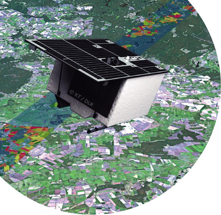
1 ENMAP RADIOMETRIC INFLIGHT CALIBRATION, POST-LAUNCH PRODUCT VALIDATION, AND INSTRUMENT CHARACTERIZATION ACTIVITIES A. Hollstein1, C. Rogass1, K. Segl1, L. Guanter1, M. Bachmann2, T. Storch2, R. Müller2, and H. Krawczyk3 1Helmholtz Centre Potsdam, GFZ German Research Centre for Geosciences 2Earth Observation Center (EOC), German Aerospace Center (DLR), Oberpfaffenhofen 3Earth Observation Center (EOC), German Aerospace Center (DLR), Berlin
2 Outline ENMAP RADIOMETRIC INFLIGHT CALIBRATION, POST-LAUNCH PRODUCT VALIDATION, AND INSTRUMENT CHARACTERIZATION ACTIVITIES

3 The Environmental Mapping and Analysis Program (EnMAP) Key Facts to be launched in June :
4 The Environmental Mapping and Analysis Program (EnMAP) Key Facts 1: 2: Guanter et al. The EnMAP Spaceborne Imaging Spectroscopy Mission for Earth Observation. Remote Sens. 2015

5 The Environmental Mapping and Analysis Program (EnMAP) Key Facts 1:
6 EnMAP Data Processing Scheme by DLR GS 1:Guanter et al. The EnMAP Spaceborne Imaging Spectroscopy Mission for Earth Observation. Remote Sens. 2015
7 EnMAP Data Processing Scheme by DLR GS Data Quality Monitoring by DLR Calibration by DLR 1:Guanter et al. The EnMAP Spaceborne Imaging Spectroscopy Mission for Earth Observation. Remote Sens. 2015
8 EnMAP Data Processing Scheme by DLR GS EnMAP Product Validation Activities by GFZ Data Quality Monitoring by DLR Calibration by DLR 1:Guanter et al. The EnMAP Spaceborne Imaging Spectroscopy Mission for Earth Observation. Remote Sens. 2015


9 On Board Spectral and Radiometric Calibration Dark values calibration: using recordings while looking at the closed shutter or into deep space Absolute Calibration: Solar calibration using full aperture diffuser assembly, also used for response non-uniformity calibration Relative radiometric calibration: monitoring of temporal changes using the large integrating sphere Spectral calibration: small integrating sphere with doped Spectralon and dedicated lamps for spectral calibration Response non-linearity: focal plane assembly LED's 1:Guanter et al. The EnMAP Spaceborne Imaging Spectroscopy Mission for Earth Observation. Remote Sens. 2015
10 In-flight Calibration Frequencies Calibration type Time Frames Frequency (planned) Dark (shutter) 23 sec 2*128 (2 gains) each datatake Dark (deep space) 30 sec 1*1024 ( 2 gains) every 4 months Relative radiance 17 min 13 sec 1*512 (5 steps) weekly Sun calibration 140 sec 2*1024 monthly Spectral calibration 5 min13 sec 1*1024 every 2 weeks Linearity measurement < 5 min 2*128*40 (2 gains) monthly
11 Objectives of GFZ Validation Activities and Characterization Plan Quantitative validation of those EnMAP products to be delivered to end-users; by independent means as considered in the ground segment: Level-1B: top of atmosphere radiance Level-1C: top of atmosphere radiance with geometric correction Level-2A: surface reflectance including geometric correction
12 Objectives of GFZ Validation and Characterization Plan - Two-Fold Approach Ground-based: Comparison of EnMAP user products to absolute references for Level-1B/C and Level-2A measurements at to be selected reference sites (e.g. CEOS sites) Validation of Atmospheric products from Level-2A processing, e.g. using AERONET sites: aerosol optical thickness, surface pressure, total columnar water vapor Using hyper spectral flight campaigns which are a benefit from other science related collaborative efforts in discussion, how exactly to do it? Scene-based: Sophisticated models and image processing techniques involved Activities considered scientific rather than operational Sensor characteristics: spectral smile, spectral shifts, Keystone, modulation transfer function (MTF) Image quality: dead and bad pixels, co-registration, artifact detection such as striping
 Known atmospheric composition (surface pressure, aerosol optical")

13 Approach for Ground-Based Validations Vicarious Calibration Comparison of EnMAP Level-1B/C products with reference radiance spectra generated from in-situ surface reflectance measurements and radiative transfer simulations Needed are: In-situ surface reflectance measurements for suitable reference site (homogeneous, ) Known atmospheric composition (surface pressure, aerosol optical thickness, total columnar water vapor) Accurate radiative transfer simulations Spectral response functions Potential benefit from airborne sensors: closer to TOA radiance and able to extend validation area to cover EnMAP s swath and to check across-track radiometric response but need a way to convert airborne data to EnMAP measurement in discussion how exactly to do it 1: EnMAP Validation Plan, EN-GFZ-CalVal, Guanter et.al 2:
14 Vicarious Validation using Airborne Sensors two approaches: 1) airborne Level-1C Level-2A trough atmospheric correction radiative transfer modeling + atmospheric parameters for total column top of atmosphere radiance Level-1C satellite products 2) airborne Level-1C radiative transfer modeling + atmospheric parameters for column above aircraft top of atmosphere radiance Level-1B/C satellite products geometric transfer to satellite instrument spectral re-sampling must be performed low earth orbit ~400km -- satellite (1) (2) L1C O3 cirrus ~1-10km -- aircraft L1C aerosol H2O O2 Earth Surface Level-2A
 Far from ocean and urban & industrial areas")

 Level-2A geometry and sensor")

15 Validation Sites* Criteria Level-1B/C toa radiance Best conditions for instrument testing (high SNR, minimal atmospheric impact, ) Far from ocean and urban & industrial areas Vegetation-free, bright and elevated targets Wide-spread over the globe Level-2A surface reflectance Under normal acquisition conditions Typical EnMAP science sites (agricultural, coastal, geological ) Included in extensive science-oriented campaigns Validation sites across the world at sea level (short-term accessible) Level-2A geometry and sensor characteristics Flat and mountainous regions spectrally heterogeneous with high spectral contrast, geologically stable *Sites to be selected before launch. 1: Guanter et al. EnMAP Validation Plan


16 Scene Based: Uniformity - Keystone and Smile Keystone and Smile/Frown are spatial deviations from an optimal projection on the detector array and part of instrument characterization line of sight and PSF for each detector Smile and Keystone are expected to be very small. pixel Spectral Smile Keystone VNIR: SWIR: 1:Guanter et al. The EnMAP Spaceborne Imaging Spectroscopy Mission for Earth Observation. Remote Sens Keystone pix Smile λ
 only as a complement of on-orbit measurements Use same atmospheric model as for the atmospheric correction algorithm maximize smoothness of surface reflectance in the")
17 Scene Based Non Uniformity Assessment If Needed - Center Wavelength Smile detection Characterization of spectral shift and smile from Level-1B/C scenes Use of atmospheric absorption features (OxygenA 760nm & water vapor 1140nm) only as a complement of on-orbit measurements Use same atmospheric model as for the atmospheric correction algorithm maximize smoothness of surface reflectance in the vicinity of atmospheric absorption bands Keystone Detection local distortion reduction factor Assumed to be stable after launch no need to apply correction to each individual image Keystone detection Sophisticated detection algorithm Mean keystone detection accuracy: >99% without outliers accuracy < 1μPixel Local distortion reduction factor ~ 1/keystone detection accuracy Keystone detection accuracy 1:Guanter, Luis, Karl Segl, Bernhard Sang, Luis Alonso, Hermann Kaufmann, and Jose Moreno. "Scene-based spectral calibration assessment of high spectral resolution imaging spectrometers." Optics express 17, no. 14 (2009): : Rogass, Christian, Maximilian Brell, Karl Segl, Theres Kuester, and Hermann Kaufmann. "Automatic reduction of keystone, applications to EnMAP." In Proceedings of the 8th EARSeL SIG imaging spectroscopy workshop; EARSeL
18 Conclusions DLR performs calibration of EnMAP products as part of Level-1A/B/C processing Pre-flight characterization (not covered in this talk) On-board dedicated calibration equipment for: Spectral calibration Detector linearity calibration Absolute calibration Uniformity... GFZ performs independent validation activities based on EnMap products Vicarious validation using yet to be defined test sites, atmospheric products e.g. from AERONET, and accurate radiative transfer Scene based assessment of modulation transfer function (MTF) Although spectral smile, spectral shifts and keystone are expected to be small, scene based assessment can be performed using sophisticated algorithms

19 Dr. André Hollstein Helmholtz-Zentrum Potsdam Deutsches GeoForschungsZentrum GFZ +49 (0)331/ Thank You
REVIEW OF ENMAP SCIENTIFIC POTENTIAL AND PREPARATION PHASE
 REVIEW OF ENMAP SCIENTIFIC POTENTIAL AND PREPARATION PHASE H. Kaufmann 1, K. Segl 1, L. Guanter 1, S. Chabrillat 1, S. Hofer 2, H. Bach 3, P. Hostert 4, A. Mueller 5, and C. Chlebek 6 1 Helmholtz Centre
Compact High Resolution Imaging Spectrometer (CHRIS) siraelectro-optics
 siraelectro-optics") Compact High Resolution Imaging Spectrometer (CHRIS) Mike Cutter (Mike_Cutter@siraeo.co.uk) Summary CHRIS Instrument Design Instrument Specification & Performance Operating Modes Calibration Plan Data
Compact High Resolution Imaging Spectrometer (CHRIS) Mike Cutter (Mike_Cutter@siraeo.co.uk) Summary CHRIS Instrument Design Instrument Specification & Performance Operating Modes Calibration Plan Data
EnMAP Environmental Mapping and Analysis Program
 EnMAP Environmental Mapping and Analysis Program www.enmap.org Mathias Schneider Mission Objectives Regular provision of high-quality calibrated hyperspectral data Precise measurement of ecosystem parameters
Five more talks to the wiskey tasting! Folie 1
 Five more talks to the wiskey tasting! Folie 1 EnMAP Environmental Mapping Programme Germanys Hyperspectral Earth Observation Mission Godela Roßner, Christian Chlebek, Christoph Straif, Albrecht von Bargen
Sentinel-2 Products and Algorithms
 Sentinel-2 Products and Algorithms Ferran Gascon (Sentinel-2 Data Quality Manager) Workshop Preparations for Sentinel 2 in Europe, Oslo 26 November 2014 Sentinel-2 Mission Mission Overview Products and
Technical Committee Report International Spaceborne Imaging Spectroscopy
 Slide 1 Geoscience and Remote Sensing Society Technical Committee Report International Spaceborne Imaging Spectroscopy Cindy Ong, CSIRO Andreas Mueller, DLR, Uta Heiden, DLR GRSS AdCom Meeting Washington,
Radiometric performance of Second Generation Global Imager (SGLI) using integrating sphere
 using integrating sphere") Radiometric performance of Second Generation Global Imager (SGLI) using integrating sphere Taichiro Hashiguchi, Yoshihiko Okamura, Kazuhiro Tanaka, Yukinori Nakajima Japan Aerospace Exploration Agency
Radiometric performance of Second Generation Global Imager (SGLI) using integrating sphere Taichiro Hashiguchi, Yoshihiko Okamura, Kazuhiro Tanaka, Yukinori Nakajima Japan Aerospace Exploration Agency
ISIS TC Meeting. International Spaceborne Imaging Spectroscopy (ISIS) GRSS Technical Committee Meeting, 16/07/2014, IGARSS 2014
 GRSS Technical Committee Meeting, 16/07/2014, IGARSS 2014") ISIS TC Meeting International Spaceborne Imaging Spectroscopy (ISIS) GRSS Technical Committee Meeting, 16/07/2014, IGARSS 2014 Andreas Müller (DLR) Cindy Ong (CSIRO) Uta Heiden (DLR) Agenda Hyperspectral
ISIS TC Meeting International Spaceborne Imaging Spectroscopy (ISIS) GRSS Technical Committee Meeting, 16/07/2014, IGARSS 2014 Andreas Müller (DLR) Cindy Ong (CSIRO) Uta Heiden (DLR) Agenda Hyperspectral
EnMAP Research, Mission Synergies & Future Perspectives
 EnMAP Research, Mission Synergies & Future Perspectives Luis Guanter German Research Centre for Geosciences (GFZ) Helmholtz Centre Potsdam Section 1.4: Remote Sensing Imaging Spectroscopy (aka Hyperspectral
Characterization of the atmospheric aerosols and the surface radiometric properties in the AGRISAR Campaign
 Characterization of the atmospheric aerosols and the surface radiometric properties in the AGRISAR Campaign V. Estellés Solar Radiation Unit Universitat de València T. Ruhtz, P. Zieger, S. Stapelberg Institute
Radiometric Use of WorldView-3 Imagery. Technical Note. 1 WorldView-3 Instrument. 1.1 WorldView-3 Relative Radiance Response
 Radiometric Use of WorldView-3 Imagery Technical Note Date: 2016-02-22 Prepared by: Michele Kuester This technical note discusses the radiometric use of WorldView-3 imagery. The first two sections briefly
DESIS Applications & Processing Extracted from Teledyne & DLR Presentations to JACIE April 14, Ray Perkins, Teledyne Brown Engineering
 DESIS Applications & Processing Extracted from Teledyne & DLR Presentations to JACIE April 14, 2016 Ray Perkins, Teledyne Brown Engineering 1 Presentation Agenda Imaging Spectroscopy Applications of DESIS
QUANTITATIVE GLOBAL MAPPING OF TERRESTRIAL VEGETATION PHOTOSYNTHESIS: THE FLUORESCENCE EXPLORER (FLEX) MISSION
 MISSION") 2017 IEEE International Geoscience and Remote Sensing Symposium July 23 28, 2017 Fort Worth, Texas, USA Session MO3.L12 - International Spaceborne Imaging Spectroscopy Missions: Updates and News I QUANTITATIVE
2017 IEEE International Geoscience and Remote Sensing Symposium July 23 28, 2017 Fort Worth, Texas, USA Session MO3.L12 - International Spaceborne Imaging Spectroscopy Missions: Updates and News I QUANTITATIVE
Kazuhiro TANAKA GCOM project team/jaxa April, 2016
 Kazuhiro TANAKA GCOM project team/jaxa April, 216 @ SPIE Asia-Pacific 216 at New Dehli, India 1 http://suzaku.eorc.jaxa.jp/gcom_c/index_j.html GCOM mission and satellites SGLI specification and IRS overview
MERIS instrument. Muriel Simon, Serco c/o ESA
 MERIS instrument Muriel Simon, Serco c/o ESA Workshop on Sustainable Development in Mountain Areas of Andean Countries Mendoza, Argentina, 26-30 November 2007 ENVISAT MISSION 2 Mission Chlorophyll case
Comprehensive Vicarious Calibration and Characterization of a Small Satellite Constellation Using the Specular Array Calibration (SPARC) Method
 Method") This document does not contain technology or Technical Data controlled under either the U.S. International Traffic in Arms Regulations or the U.S. Export Administration Regulations. Comprehensive Vicarious
This document does not contain technology or Technical Data controlled under either the U.S. International Traffic in Arms Regulations or the U.S. Export Administration Regulations. Comprehensive Vicarious
Remote Sensing Calibration Solutions
 Remote Sensing Calibration Solutions Cameras, Sensors and Focal Plane Arrays Multispectral and Hyperspectral Imagers Small Satellite Imagers Earth Observation Systems SWIR Band Science and Imaging Reconnaissance
1. INTRODUCTION. GOCI : Geostationary Ocean Color Imager
 1. INTRODUCTION The Korea Ocean Research and Development Institute (KORDI) releases an announcement of opportunity (AO) to carry out scientific research for the utilization of GOCI data. GOCI is the world
DEFENSE APPLICATIONS IN HYPERSPECTRAL REMOTE SENSING
 DEFENSE APPLICATIONS IN HYPERSPECTRAL REMOTE SENSING James M. Bishop School of Ocean and Earth Science and Technology University of Hawai i at Mānoa Honolulu, HI 96822 INTRODUCTION This summer I worked
Airborne Hyperspectral Remote Sensing
 Airborne Hyperspectral Remote Sensing Curtiss O. Davis Code 7212 Naval Research Laboratory 4555 Overlook Ave. S.W. Washington, D.C. 20375 phone (202) 767-9296 fax (202) 404-8894 email: davis@rsd.nrl.navy.mil
Hyperspectral Systems: Recent Developments and Low Cost Sensors. 56th Photogrammetric Week in Stuttgart, September 11 to September 15, 2017
 Hyperspectral Systems: Recent Developments and Low Cost Sensors 56th Photogrammetric Week in Stuttgart, September 11 to September 15, 2017 Ralf Reulke Humboldt-Universität zu Berlin Institut für Informatik,
The studies began when the Tiros satellites (1960) provided man s first synoptic view of the Earth s weather systems.
 provided man s first synoptic view of the Earth s weather systems.") Remote sensing of the Earth from orbital altitudes was recognized in the mid-1960 s as a potential technique for obtaining information important for the effective use and conservation of natural resources.
Remote sensing of the Earth from orbital altitudes was recognized in the mid-1960 s as a potential technique for obtaining information important for the effective use and conservation of natural resources.
RADIOMETRIC CALIBRATION
 1 RADIOMETRIC CALIBRATION Lecture 10 Digital Image Data 2 Digital data are matrices of digital numbers (DNs) There is one layer (or matrix) for each satellite band Each DN corresponds to one pixel 3 Digital
The Hyperspectral UAV (HyUAV) a novel UAV-based spectroscopy tool for environmental monitoring
 a novel UAV-based spectroscopy tool for environmental monitoring") The Hyperspectral UAV (HyUAV) a novel UAV-based spectroscopy tool for environmental monitoring R. Garzonio 1, S. Cogliati 1, B. Di Mauro 1, A. Zanin 2, B. Tattarletti 2, F. Zacchello 2, P. Marras 2 and
The Hyperspectral UAV (HyUAV) a novel UAV-based spectroscopy tool for environmental monitoring R. Garzonio 1, S. Cogliati 1, B. Di Mauro 1, A. Zanin 2, B. Tattarletti 2, F. Zacchello 2, P. Marras 2 and
Calibration of a Multi-Spectral CubeSat with LandSat Filters
 Calibration of a Multi-Spectral CubeSat with LandSat Filters Sloane Wiktorowicz, Ray Russell, Dee Pack, Eric Herman, George Rossano, Christopher Coffman, Brian Hardy, & Bonnie Hattersley (The Aerospace
Textbook, Chapter 15 Textbook, Chapter 10 (only 10.6)
") AGOG 484/584/ APLN 551 Fall 2018 Concept definition Applications Instruments and platforms Techniques to process hyperspectral data A problem of mixed pixels and spectral unmixing Reading Textbook, Chapter
AGOG 484/584/ APLN 551 Fall 2018 Concept definition Applications Instruments and platforms Techniques to process hyperspectral data A problem of mixed pixels and spectral unmixing Reading Textbook, Chapter
Cross Calibration of the Landsat-7 ETM+ and EO-1 ALI Sensor. Gyanesh Chander, David J. Meyer, and Dennis L. Helder, Member, IEEE
 IEEE TRANSACTIONS ON GEOSCIENCE AND REMOTE SENSING, VOL. 42, NO. 12, DECEMBER 2004 2821 Cross Calibration of the Landsat-7 ETM+ and EO-1 ALI Sensor Gyanesh Chander, David J. Meyer, and Dennis L. Helder,
IDEAS+ WP3520 Calibration and data quality toolbox. July 2016 Steve Mackin James Warner
 IDEAS+ WP3520 Calibration and data quality toolbox July 2016 Steve Mackin James Warner Proposition : Every image contains the same information Railroad Valley, Nevada London, UK Rationale for the project
ESA's activities in space-borne Imaging Spectroscopy for Earth Observation CHII, June 2016, Graz, Austria
 ESA's activities in space-borne Imaging Spectroscopy for Earth Observation CHII, 15-16 June 2016, Graz, Austria Michael Rast, ESA Observation Principle of Imaging Spectrometer The telescope images the
Atmospheric interactions; Aerial Photography; Imaging systems; Intro to Spectroscopy Week #3: September 12, 2018
 GEOL 1460/2461 Ramsey Introduction/Advanced Remote Sensing Fall, 2018 Atmospheric interactions; Aerial Photography; Imaging systems; Intro to Spectroscopy Week #3: September 12, 2018 I. Quick Review from
of the Small Satellite Mission Systematic Image Processing Eckehard Lorenz, DLR Berlin Ilmenau, Klaus Briess, TU Berlin 49th IWK
 Ilmenau, 27.-30.09. 2004 49th IWK Eckehard Lorenz, DLR Berlin Klaus Briess, TU Berlin Astro- und Feinwerktechnik Adlershof GmbH Systematic Image Processing of the Small Satellite Mission BIRD Optical Information
Application of GIS to Fast Track Planning and Monitoring of Development Agenda
 Application of GIS to Fast Track Planning and Monitoring of Development Agenda Radiometric, Atmospheric & Geometric Preprocessing of Optical Remote Sensing 13 17 June 2018 Outline 1. Why pre-process remotely
AN UPDATE OF MICROCARB PROJECT PROGRESS AND PERSPECTIVE.
 AN UPDATE OF MICROCARB PROJECT PROGRESS AND PERSPECTIVE. PROJECT STATUS Francois BUISSON CNES June 8th, 2017 1 13th IWGGMS Helsinki June 6-8, 2017 PROJECT IMPLEMENTATION STATUS Decision milestones è Dec.,
The CarbonSat candidate mission - Radiometric and Spectral Performances over Spatially Heterogeneous Scenes
 The CarbonSat candidate mission - Radiometric and Spectral Performances over Spatially Heterogeneous Scenes J. Caron, B. Sierk, J.-L. Bézy, A. Loescher, Y. Meijer ESA-Estec (Netherlands) Earth Observation
PLANET SURFACE REFLECTANCE PRODUCT
 PLANET SURFACE REFLECTANCE PRODUCT FEBRUARY 2018 SUPPORT@PLANET.COM PLANET.COM VERSION 1.0 TABLE OF CONTENTS 3 Product Description 3 Atmospheric Correction Methodology 5 Product Limitations 6 Product Assessment
On-Orbit Radiometric Performance of the Landsat 8 Thermal Infrared Sensor. External Editors: James C. Storey, Ron Morfitt and Prasad S.
 Remote Sens. 2014, 6, 11753-11769; doi:10.3390/rs61211753 OPEN ACCESS remote sensing ISSN 2072-4292 www.mdpi.com/journal/remotesensing Article On-Orbit Radiometric Performance of the Landsat 8 Thermal
Airborne hyperspectral data over Chikusei
 SPACE APPLICATION LABORATORY, THE UNIVERSITY OF TOKYO Airborne hyperspectral data over Chikusei Naoto Yokoya and Akira Iwasaki E-mail: {yokoya, aiwasaki}@sal.rcast.u-tokyo.ac.jp May 27, 2016 ABSTRACT Airborne
CALIBRATION OF THE LH SYSTEMS ADS40 AIRBORNE DIGITAL SENSOR
 CALIBRATION OF THE LH SYSTEMS ADS4 AIRBORNE DIGITAL SENSOR Reinhard SCHUSTER*, Bernhard BRAUNECKER** *Deutsches Zentrum für Luft- und Raumfahrt (DLR), Germany Institute of Space Sensor Technology and Planetary
Japan's Greenhouse Gases Observation from Space
 1 Workshop on EC CEOS Priority on GHG Monitoring Japan's Greenhouse Gases Observation from Space 18 June, 2018@Ispra, Italy Masakatsu NAKAJIMA Japan Aerospace Exploration Agency Development and Operation
VICARIOUS CALIBRATION SITE SELECTION FOR RAZAKSAT MEDIUM-SIZED APERTURE CAMERA (MAC)
") VICARIOUS CALIBRATION SITE SELECTION FOR RAZAKSAT MEDIUM-SIZED APERTURE CAMERA (MAC) Lee Yee Hwai a, Mazlan Hashim b, Ahmad Sabirin Arshad a a Astronautic Technology (M) Sdn Bhd (yee_hwai, sabirin)@atsb.com.my
VICARIOUS CALIBRATION SITE SELECTION FOR RAZAKSAT MEDIUM-SIZED APERTURE CAMERA (MAC) Lee Yee Hwai a, Mazlan Hashim b, Ahmad Sabirin Arshad a a Astronautic Technology (M) Sdn Bhd (yee_hwai, sabirin)@atsb.com.my
AVHRR/3 Operational Calibration
 AVHRR/3 Operational Calibration Jörg Ackermann, Remote Sensing and Products Division 1 Workshop`Radiometric Calibration for European Missions, 30/31 Aug. 2017`,Frascati (EUM/RSP/VWG/17/936014) AVHRR/3
Performance status of IASI on MetOp-A and MetOp-B
 Performance status of IASI on MetOp-A and MetOp-B E. Jacquette (1), E. Péquignot (1), J. Chinaud (1), C. Maraldi (1), D. Jouglet (1), S. Gaugain (1), L. Buffet (1), C. Villaret (1), C. Larigauderie (1),
From Proba-V to Proba-MVA
 From Proba-V to Proba-MVA Fabrizio Niro ESA Sensor Performances Products and Algorithm (SPPA) ESA UNCLASSIFIED - For Official Use Proba-V extension in the Copernicus era Proba-V was designed with the main
Observing Nightlights from Space with TEMPO James L. Carr 1,Xiong Liu 2, Brian D. Baker 3 and Kelly Chance 2
 Observing Nightlights from Space with TEMPO James L. Carr 1,Xiong Liu 2, Brian D. Baker 3 and Kelly Chance 2 September 27, 2016 1 Carr Astronautics Corp., Greenbelt, MD, USA jcarr@carrastro.com 2 Harvard-Smithsonian
OVERVIEW OF KOMPSAT-3A CALIBRATION AND VALIDATION
 OVERVIEW OF KOMPSAT-3A CALIBRATION AND VALIDATION DooChun Seo 1, GiByeong Hong 1, ChungGil Jin 1, DaeSoon Park 1, SukWon Ji 1 and DongHan Lee 1 1 KARI(Korea Aerospace Space Institute), 45, Eoeun-dong,
Chapter 5. Preprocessing in remote sensing
 Chapter 5. Preprocessing in remote sensing 5.1 Introduction Remote sensing images from spaceborne sensors with resolutions from 1 km to < 1 m become more and more available at reasonable costs. For some
John P. Stevens HS: Remote Sensing Test
 Name(s): Date: Team name: John P. Stevens HS: Remote Sensing Test 1 Scoring: Part I - /18 Part II - /40 Part III - /16 Part IV - /14 Part V - /93 Total: /181 2 I. History (3 pts. each) 1. What is the name
3/31/03. ESM 266: Introduction 1. Observations from space. Remote Sensing: The Major Source for Large-Scale Environmental Information
 Remote Sensing: The Major Source for Large-Scale Environmental Information Jeff Dozier Observations from space Sun-synchronous polar orbits Global coverage, fixed crossing, repeat sampling Typical altitude
Status of the CNES / MicroCarb small
 Status of the CNES / MicroCarb small satellite for CO 2 measurements D. Jouglet on behalf of the MicroCarb team (F. Buisson, D. Pradines, V. Pascal, C. Pierangelo, C. Buil, S. Gaugain, C. Deniel, F.M.
Recent developments in Deep Blue satellite aerosol data products from NASA GSFC
 Recent developments in Deep Blue satellite aerosol data products from NASA GSFC Andrew M. Sayer, N. Christina Hsu (PI), Corey Bettenhausen, Myeong-Jae Jeong Climate & Radiation Laboratory, NASA Goddard
Ground Truth for Calibrating Optical Imagery to Reflectance
 Visual Information Solutions Ground Truth for Calibrating Optical Imagery to Reflectance The by: Thomas Harris Whitepaper Introduction: Atmospheric Effects on Optical Imagery Remote sensing of the Earth
Wind Imaging Spectrometer and Humidity-sounder (WISH): a Practical NPOESS P3I High-spatial Resolution Sensor
: a Practical NPOESS P3I High-spatial Resolution Sensor") Wind Imaging Spectrometer and Humidity-sounder (WISH): a Practical NPOESS P3I High-spatial Resolution Sensor Jeffery J. Puschell Raytheon Space and Airborne Systems, El Segundo, California Hung-Lung Huang
Wind Imaging Spectrometer and Humidity-sounder (WISH): a Practical NPOESS P3I High-spatial Resolution Sensor Jeffery J. Puschell Raytheon Space and Airborne Systems, El Segundo, California Hung-Lung Huang
Int n r t o r d o u d c u ti t on o n to t o Remote Sensing
 Introduction to Remote Sensing Definition of Remote Sensing Remote sensing refers to the activities of recording/observing/perceiving(sensing)objects or events at far away (remote) places. In remote sensing,
Camera Calibration Certificate No: DMC III 27542
 Calibration DMC III Camera Calibration Certificate No: DMC III 27542 For Peregrine Aerial Surveys, Inc. #201 1255 Townline Road Abbotsford, B.C. V2T 6E1 Canada Calib_DMCIII_27542.docx Document Version
Hyperspectral goes to UAV and thermal
 Hyperspectral goes to UAV and thermal Timo Hyvärinen, Hannu Holma and Esko Herrala SPECIM, Spectral Imaging Ltd, Finland www.specim.fi Outline Roadmap to more compact, higher performance hyperspectral
Passive Microwave Sensors LIDAR Remote Sensing Laser Altimetry. 28 April 2003
 Passive Microwave Sensors LIDAR Remote Sensing Laser Altimetry 28 April 2003 Outline Passive Microwave Radiometry Rayleigh-Jeans approximation Brightness temperature Emissivity and dielectric constant
On the use of water color missions for lakes in 2021
 Lakes and Climate: The Role of Remote Sensing June 01-02, 2017 On the use of water color missions for lakes in 2021 Cédric G. Fichot Department of Earth and Environment 1 Overview 1. Past and still-ongoing
Table (1).Operation modes and configuration in CHRIS sensor [3] Operating No of. Keyword CHRIS Sensor, De-Striping, Electronic Effect, Noise.
![Table (1).Operation modes and configuration in CHRIS sensor [3] Operating No of. Keyword CHRIS Sensor, De-Striping, Electronic Effect, Noise.](/thumbs/90/102002832.jpg "Table (1).Operation modes and configuration in CHRIS sensor [3] Operating No of. Keyword CHRIS Sensor, De-Striping, Electronic Effect, Noise.") Detection and Elimination of Striped Noise in CHRIS-PROBA Sensor Images Mohammad Reza Mobasheri Associate Professor, Remote Sensing Department, KhajeNasirToosi University of Technology, Tehran, Islamic
Detection and Elimination of Striped Noise in CHRIS-PROBA Sensor Images Mohammad Reza Mobasheri Associate Professor, Remote Sensing Department, KhajeNasirToosi University of Technology, Tehran, Islamic
Lecture 6: Multispectral Earth Resource Satellites. The University at Albany Fall 2018 Geography and Planning
 Lecture 6: Multispectral Earth Resource Satellites The University at Albany Fall 2018 Geography and Planning Outline SPOT program and other moderate resolution systems High resolution satellite systems
NEC s EO Sensors and Data Applications
 NEC s EO Sensors and Data Applications Second Singapore Space Symposium 30 September, 2015 Nanyang Technological University, Singapore Shimpei Kondo Space Technologies Department, Space System Division,
Status of Aqua MODIS Reflective Solar Bands Calibration and Performance
 EOS Status of Aqua MODIS Reflective Solar Bands Calibration and Performance Jack Xiong NASA GSFC, Greenbelt, MD 20771, USA A. Angal, H. Chen, X. Geng, D. Link, Y. Li, and A. Wu SSAI, 10210 Greenbelt Road,
Advanced Optical Satellite (ALOS-3) Overviews
 Overviews") K&C Science Team meeting #24 Tokyo, Japan, January 29-31, 2018 Advanced Optical Satellite (ALOS-3) Overviews January 30, 2018 Takeo Tadono 1, Hidenori Watarai 1, Ayano Oka 1, Yousei Mizukami 1, Junichi
K&C Science Team meeting #24 Tokyo, Japan, January 29-31, 2018 Advanced Optical Satellite (ALOS-3) Overviews January 30, 2018 Takeo Tadono 1, Hidenori Watarai 1, Ayano Oka 1, Yousei Mizukami 1, Junichi
remote sensing? What are the remote sensing principles behind these Definition
 Introduction to remote sensing: Content (1/2) Definition: photogrammetry and remote sensing (PRS) Radiation sources: solar radiation (passive optical RS) earth emission (passive microwave or thermal infrared
MicroCarb Mission: A new space instrumental concept based on dispersive components for the measurement of CO2 concentration in the atmosphere
 International Conference on Space Optics 2012 MicroCarb Mission: A new space instrumental concept based on dispersive components for the measurement of CO2 concentration in the atmosphere Véronique PASCAL
Chapter 8. Remote sensing
 1. Remote sensing 8.1 Introduction 8.2 Remote sensing 8.3 Resolution 8.4 Landsat 8.5 Geostationary satellites GOES 8.1 Introduction What is remote sensing? One can describe remote sensing in different
SHALOM: SPACEBORNE HYPERSPECTRAL APPLICATIVE LAND AND OCEAN MISSION: A JOINT PROJECT OF ASI-ISA AN UPDTAE FOR 2014
 SHALOM: SPACEBORNE HYPERSPECTRAL APPLICATIVE LAND AND OCEAN MISSION: A JOINT PROJECT OF ASI-ISA AN UPDTAE FOR 2014 Eyal Ben Dor Tel Aviv University Avia Kafri Israel Space Agency (ISA) Giancarlo Varacalli
Status of MODIS, VIIRS, and OLI Sensors
 Status of MODIS, VIIRS, and OLI Sensors Xiaoxiong (Jack) Xiong, Jim Butler, and Brian Markham Code 618.0 NASA/GSFC, Greenbelt, MD 20771, USA Acknowledgements: NASA MODIS Characterization Support Team (MCST)
Evaluation of FLAASH atmospheric correction. Note. Note no SAMBA/10/12. Authors. Øystein Rudjord and Øivind Due Trier
 Evaluation of FLAASH atmospheric correction Note Note no Authors SAMBA/10/12 Øystein Rudjord and Øivind Due Trier Date 16 February 2012 Norsk Regnesentral Norsk Regnesentral (Norwegian Computing Center,
The Challenge. SPOT Vegetation. miniaturization. Proba Vegetation. Technology assessment:
 The Challenge Spot-5 lifetime expires in 2012. The next French satellite, Pleiades, is solely dedicated to HiRes. The Belgian Federal Science Policy Office (BELSPO) declared their interest to develop an
The Global Imager (GLI)
") The Global Imager (GLI) Launch : Dec.14, 2002 Initial check out : to Apr.14, 2003 (~L+4) First image: Jan.25, 2003 Second image: Feb.6 and 7, 2003 Calibration and validation : to Dec.14, 2003(~L+4) for
The Global Imager (GLI) Launch : Dec.14, 2002 Initial check out : to Apr.14, 2003 (~L+4) First image: Jan.25, 2003 Second image: Feb.6 and 7, 2003 Calibration and validation : to Dec.14, 2003(~L+4) for
The mission concept includes eight visible-to-near-infrared bands,, and a centered at Korea.
 eostationary cean olor mager : ommunication cean and eteorological atellite It shall be operated in a mode onboard its COMS. The mission concept includes eight visible-to-near-infrared bands,, and a centered
METimage Calibration & Performance Verification. Xavier Gnata ICSO 2016
 METimage Calibration & Performance Verification Xavier Gnata ICSO 2016 METimage factsheet Mission Passive imaging radiometer (multi-spectral) 20 spectral channels (443 13.345nm) Global coverage within
THE NEW HYPERSPECTRAL SENSOR DESIS ON THE MULTI-PAYLOAD PLATFORM MUSES INSTALLED ON THE ISS
 The International Archives of the Photogrammetry, Remote Sensing and Spatial Information Sciences, Volume LI-B1, 2016 III ISPRS Congress, 12 19 July 2016, Prague, Czech Republic THE NEW HYPERSPECTRAL SENSOR
An Introduction to Remote Sensing & GIS. Introduction
 An Introduction to Remote Sensing & GIS Introduction Remote sensing is the measurement of object properties on Earth s surface using data acquired from aircraft and satellites. It attempts to measure something
MERLIN Mission Status
 MERLIN Mission Status CNES/illustration David DUCROS, 2016 G. Ehret 1, P. Bousquet 2, B. Millet 3, M. Alpers 1, C. Deniel 3, A. Friker 1, C. Pierangelo 3 1 Deutsches Zentrum für Luft- und Raumfahrt (DLR)
Sensor resolutions from space: the tension between temporal, spectral, spatial and swath. David Bruce UniSA and ISU
 Sensor resolutions from space: the tension between temporal, spectral, spatial and swath David Bruce UniSA and ISU 1 Presentation aims 1. Briefly summarize the different types of satellite image resolutions
Chapter 5 Nadir looking UV measurement.
 Chapter 5 Nadir looking UV measurement. Part-II: UV polychromator instrumentation and measurements -A high SNR and robust polychromator using a 1D array detector- UV spectrometers onboard satellites have
Two-linear-polarization measurement of O 2 A band with TANSO-FTS onboard GOSAT
 Remote sensing in the O 2 A band Two-linear-polarization measurement of O 2 A band with TANSO-FTS onboard GOSAT July 7, 2016, De Bilt Akihiko Kuze, Hiroshi Suto, Kei Shiomi, Nobuhiro Kikuchi, Makiko Hashimoto
THE HYMAP TM AIRBORNE HYPERSPECTRAL SENSOR: THE SYSTEM, CALIBRATION AND PERFORMANCE
 THE HYMAP TM AIRBORNE HYPERSPECTRAL SENSOR: THE SYSTEM, CALIBRATION AND PERFORMANCE T. Cocks, R. Jenssen, A. Stewart, I. Wilson* and T. Shields* Integrated Spectronics Pty Ltd, P.O. Box 437, Baulkham Hills,
The Ground-Based Absolute Radiometric Calibration of Landsat 8 OLI
 Remote Sens. 2015, 7, 600-626; doi:10.3390/rs70100600 Article OPEN ACCESS remote sensing ISSN 2072-4292 www.mdpi.com/journal/remotesensing The Ground-Based Absolute Radiometric Calibration of Landsat 8
Band to Band Calibration and Relative Gain Analysis of Satellite Sensors Using Deep Convective Clouds
 South Dakota State University Open PRAIRIE: Open Public Research Access Institutional Repository and Information Exchange Theses and Dissertations 2015 Band to Band Calibration and Relative Gain Analysis
VENµS: A Joint French Israeli Earth Observation Scientific Mission with High Spatial and Temporal Resolution Capabilities
 VENµS: A Joint French Israeli Earth Observation Scientific Mission with High Spatial and Temporal Resolution Capabilities G. Dedieu 1, A. Karnieli 2, O. Hagolle 3, H. Jeanjean 3, F. Cabot 3, P. Ferrier
ESA UNCLASSIFIED - For Official Use
 ESA UNCLASSIFIED - For Official Use A Hyperspectral Mission for Sentinel-2 Data Product Validation of a Northern Ombrotrophic Bog Soffer R. J., Arroyo-Mora J.P., Kalacska M., White, H.P., Ifimov G., Leblanc
Norsk Elektro Optikk AS (NEO) HySpex Airborne Sensors System Overview
 HySpex Airborne Sensors System Overview") Norsk Elektro Optikk AS (NEO) HySpex Airborne Sensors System Overview Trond Løke Research Scientist EUFAR meeting 14.04.2011 Outline Norsk Elektro Optikk AS (NEO) NEO company profile HySpex Optical Design
Norsk Elektro Optikk AS (NEO) HySpex Airborne Sensors System Overview Trond Løke Research Scientist EUFAR meeting 14.04.2011 Outline Norsk Elektro Optikk AS (NEO) NEO company profile HySpex Optical Design
Hyperspectral Systems: Recent Developments and Low Cost Sensors
 Hyperspectral Systems: Recent Developments and Low Cost Sensors Ralf Reulke 1, 2 Humboldt-Universität zu Berlin, Computer Vision 1 Unter den Linden 6, 10099 Berlin, DLR German Aerospace Center, Institute
29 th Annual Louisiana RS/GIS Workshop April 23, 2013 Cajundome Convention Center Lafayette, Louisiana
 Landsat Data Continuity Mission 29 th Annual Louisiana RS/GIS Workshop April 23, 2013 Cajundome Convention Center Lafayette, Louisiana http://landsat.usgs.gov/index.php# Landsat 5 Sets Guinness World Record
NORMALIZING ASTER DATA USING MODIS PRODUCTS FOR LAND COVER CLASSIFICATION
 NORMALIZING ASTER DATA USING MODIS PRODUCTS FOR LAND COVER CLASSIFICATION F. Gao a, b, *, J. G. Masek a a Biospheric Sciences Branch, NASA Goddard Space Flight Center, Greenbelt, MD 20771, USA b Earth
Earth-observing satellite intercomparison using the Radiometric Calibration Test Site at Railroad Valley
 Earth-observing satellite intercomparison using the Radiometric Calibration Test Site at Railroad Valley Jeffrey Czapla-Myers Joel McCorkel Nikolaus Anderson Stuart Biggar Jeffrey Czapla-Myers, Joel McCorkel,
746A27 Remote Sensing and GIS. Multi spectral, thermal and hyper spectral sensing and usage
 746A27 Remote Sensing and GIS Lecture 3 Multi spectral, thermal and hyper spectral sensing and usage Chandan Roy Guest Lecturer Department of Computer and Information Science Linköping University Multi
Camera Calibration Certificate No: DMC II
 Calibration DMC II 230 027 Camera Calibration Certificate No: DMC II 230 027 For Peregrine Aerial Surveys, Inc. 103-20200 56 th Ave Langley, BC V3A 8S1 Canada Calib_DMCII230-027.docx Document Version 3.0
Atmospheric Correction for Coastal and Inland Waters Current Capabilities and Challenges
 Atmospheric Correction for Coastal and Inland Waters Current Capabilities and Challenges Nima Pahlevan Research Scientist NASA Goddard Space Flight Center Science Systems and Applications Inc. Outline
MR-i. Hyperspectral Imaging FT-Spectroradiometers Radiometric Accuracy for Infrared Signature Measurements
 MR-i Hyperspectral Imaging FT-Spectroradiometers Radiometric Accuracy for Infrared Signature Measurements FT-IR Spectroradiometry Applications Spectroradiometry applications From scientific research to
OPAL Optical Profiling of the Atmospheric Limb
 OPAL Optical Profiling of the Atmospheric Limb Alan Marchant Chad Fish Erik Stromberg Charles Swenson Jim Peterson OPAL STEADE Mission Storm Time Energy & Dynamics Explorers NASA Mission of Opportunity
CHARACTERISTICS OF REMOTELY SENSED IMAGERY. Radiometric Resolution
 CHARACTERISTICS OF REMOTELY SENSED IMAGERY Radiometric Resolution There are a number of ways in which images can differ. One set of important differences relate to the various resolutions that images express.
1. Theory of remote sensing and spectrum
 1. Theory of remote sensing and spectrum 7 August 2014 ONUMA Takumi Outline of Presentation Electromagnetic wave and wavelength Sensor type Spectrum Spatial resolution Spectral resolution Mineral mapping
NIST Agency Report May 2012 OUTLINE. The case for traceability NMI capabilities A view to the future the HIP Current/recent NIST activities
 NIST Agency Report May 2012 OUTLINE The case for traceability NMI capabilities A view to the future the HIP Current/recent NIST activities The case for traceability Earth Radiation Budget: Solar irradiance
MR-i. Hyperspectral Imaging FT-Spectroradiometers Radiometric Accuracy for Infrared Signature Measurements
 MR-i Hyperspectral Imaging FT-Spectroradiometers Radiometric Accuracy for Infrared Signature Measurements FT-IR Spectroradiometry Applications Spectroradiometry applications From scientific research to
Recent Research progress of Cal&Val Comprehensive Site and payload performance Assessment
 Academy of Opto-Electronics, Chinese Academy of Sciences Recent Research progress of Cal&Val Comprehensive Site and payload performance Assessment Lingling Ma Mar. 19 2013 IVOS 25 Infrared and Visible
NON-PHOTOGRAPHIC SYSTEMS: Multispectral Scanners Medium and coarse resolution sensor comparisons: Landsat, SPOT, AVHRR and MODIS
 NON-PHOTOGRAPHIC SYSTEMS: Multispectral Scanners Medium and coarse resolution sensor comparisons: Landsat, SPOT, AVHRR and MODIS CLASSIFICATION OF NONPHOTOGRAPHIC REMOTE SENSORS PASSIVE ACTIVE DIGITAL
IKONOS High Resolution Multispectral Scanner Sensor Characteristics
 High Spatial Resolution and Hyperspectral Scanners IKONOS High Resolution Multispectral Scanner Sensor Characteristics Launch Date View Angle Orbit 24 September 1999 Vandenberg Air Force Base, California,