Sentinel-2 Products and Algorithms
|
|
|
- Laurence Norman
- 6 years ago
- Views:
Transcription

 Workshop")

1 Sentinel-2 Products and Algorithms Ferran Gascon (Sentinel-2 Data Quality Manager) Workshop Preparations for Sentinel 2 in Europe, Oslo 26 November 2014

2 Sentinel-2 Mission Mission Overview Products and Algorithms Mission Performance Centre (MPC)
3 Sentinel-2 Mission Mission Overview Products and Algorithms Mission Performance Centre (MPC)
 Spatial resolution: 10m / 20m / 60m Swath: 290 km Sentinel-2 A/B/C/D Sentinel-2 Second")
4 Mission Features Spacecrafts: 2 operating in twin configuration Orbit: Sun-synchronous at 786 km (14+3/10 revs per day), with LTDN 10:30 AM MultiSpectral Instrument (MSI): pushbroom principle, filter-based optical system Spectral bands: 13 (in VIS NIR SWIR) Spatial resolution: 10m / 20m / 60m Swath: 290 km Sentinel-2 A/B/C/D Sentinel-2 Second Generation A/B
5 Spectral Bands and Spatial Resolution VNIR SWIR VIS NIR SWIR Visible B1 B9 B10 60 m Aerosols Water-vapour Cirrus B5 B7 B8a Vegetation status Snow / ice / cloud discrimination 20 m Vegetation Red-edge B6 B11 B12 10 m 400 nm B2 B3 B4 B8 600 nm 800 nm 1000 nm 1200 nm 1400 nm 1600 nm 1800 nm 2000 nm 2200 nm 2400 nm
 Accurate AOCS based on multi-head Star Tracker and fiber optic gyro X band mission data distribution (520 Mbits/sec) Mission data onboard storage: 2.")

6 Satellite and Instrument Satellite Satellite mass: 1200 kg Satellite power consumption: 1250 W Hydrazine propulsion system (120 kg - including provision for safe mode, debris avoidance and EOL orbit decrease for faster re-entry) Accurate AOCS based on multi-head Star Tracker and fiber optic gyro X band mission data distribution (520 Mbits/sec) Mission data onboard storage: 2.4 Tbits Multi-Spectral instrument (MSI) Filter based push broom imager (280 kg, 1 m 3 ) Three mirrors silicon carbide telescope, with dichroic beam splitter Focal plane arrays: Si CMOS VNIR detectors, HgCdTe SWIR detectors. Onboard wavelet compression (divided by 3) Integrated video & compression electronics (state of the art wavelet compression) Radiometric resolution 12bits Daily generated telemetry: 1.4 TB
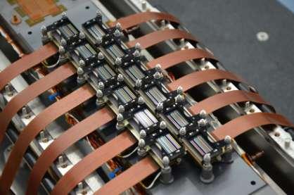
7 Multi-Spectral Instrument (MSI)
8 The Uniqueness of Sentinel-2 Sentinel-2 mission will combine a unique set of features: 1. Systematic acquisition of all land surfaces and coastal waters. 2. High revisit frequency (5 days periodicity, same viewing direction). 3. Large swath (290km). 4. High spatial resolution (10m / 20m / 60m). 5. Large number of spectral bands (13 in VNIR-SWIR domain).
9 Sentinel-2 Mission Mission Overview Products and Algorithms Mission Performance Centre (MPC)
10 Sentinel-2 Products Name High-level Description Production Preservation Strategy Level-1B Top-of-atmophere radiances in sensor geometry Volume Systematic Long-term 27 MB (each 25x23km 2 ) Level-1C Top-of-atmosphere reflectances in cartographic geometry Systematic Long-term 500 MB (each 100x100km 2 ) Level-2A Bottom-of-atmosphere reflectances in cartographic geometry (prototype product) On user side (using Sentinel-2 Toolbox*) N/A 600 MB (each 100x100km 2 ) *:
11 Products Level-1B Level-1C Level-2A

12 Products Level-1B
13 Level-1B / Definition Top-of-atmosphere (TOA) radiances in sensor geometry. Image radiometry key features: Radiometric corrections for: dark signal, pixel response nonuniformity, defective pixels, etc. Radiances coded in 12 bits. Image geometry key features: Coarse registration between bands and between staggered detectors (no resampling). Includes a refined geometrical viewing model calculated using a GRI (Global Reference Image).


14 Level-1B / Product Example 290 km swath Granule 23 km 25 km Along satellite-track
15 Level-1B / Algorithm Level-0 Level-0 Consolidated Level-1A Level-1B Level-1C TELEMETRY ANALYSIS PRELIMINARY QUICK- LOOK AND CLOUD MASK GENERATION DECOMPESSION SWIR PIXELS REARRANGEMENT RADIOMETRIC CORRECTIONS - Inv. on-board equalization, - Dark signal correction, - Blind pixels removal, - Cross-talk correction, - Relative response correction, - Defective/no-data correction, - Deconvolution/Denoising, - Binning of 60m bands. RESAMPLING - Geometry interpolation grid computation, - Resampling (B-splines). CONVERSION TO REFLECTANCES GEOMETRIC VIEWING MODEL REFINEMENT PREVIEW IMAGE AND MASKS GENERATION (defective pixels, cloud & land/water) - Refining of the viewing model using a global set of reference images, - Registration between VNIR and SWIR focal planes (optional). Algorithms developed with
16 Level-1C Product Level-1C
17 Level-1C / Definition Top-of-atmosphere (TOA) reflectances in cartographic geometry Radiometry: Reflectances coded in 12 bits. Product includes all necessary parameters required to convert the provided reflectances into radiances. Geometry: Projection UTM / WGS84. Orthorectification uses an 90m-resolution DEM (PlanetDEM). Sub-pixel multi-temporal registration between images.

.")

18 Level-1C / Tiling Cartographic Reference System: UTM (with 6ºx8º grid zones). Each grid zone is split into ~100x100km 2 UTM Tiles. 100km x 100km tile

19 Level-1C / Tile Example 100 km RGB composite of a Level-1C Tile
20 Level-1C / Algorithm Level-0 Level-0 Consolidated Level-1A Level-1B Level-1C TELEMETRY ANALYSIS PRELIMINARY QUICK- LOOK AND CLOUD MASK GENERATION DECOMPESSION SWIR PIXELS REARRANGEMENT RADIOMETRIC CORRECTIONS - Inv. on-board equalization, - Dark signal correction, - Blind pixels removal, - Cross-talk correction, - Relative response correction, - Defective/no-data correction, - Deconvolution/Denoising, - Binning of 60m bands. RESAMPLING - Geometry interpolation grid computation, - Resampling (B-splines). CONVERSION TO REFLECTANCES GEOMETRIC VIEWING MODEL REFINEMENT PREVIEW IMAGE AND MASKS GENERATION (defective pixels, cloud & land/water) - Refining of the viewing model using a global set of reference images, - Registration between VNIR and SWIR focal planes (optional).
21 Level-1C / Data Quality Targets Radiometric Data Quality Absolute radiometric uncertainty 3 % (goal), 5 % (threshold) Inter-band relative radiometric uncertainty 3% Linearity knowledge accuracy 1% Modulation Transfer Function (MTF) 0.15 to 0.3 (for 10m bands) <0.45 (for 20 & 60m bands) Geometric Data Quality Absolute geolocation uncertainty 20m 2σ (threshold) 12.5m 2σ (goal) with GCPs Multi-temporal registration Multi-spectral registration (for any couple of spectral bands) 0.3 pixel 2σ (goal) with GCPs 0.3 pixel 3σ
22 Level-2A Product Level-2A
23 Level-2A / Definition Bottom-of-atmosphere (BOA) reflectances in cartographic geometry. Products additionally include: Scene Classification Map Water Vapour Map Aerosols Optical Thickness Map Algorithm includes: Cloud and cloud shadow detection. Cirrus detection and correction. Slope effect correction. BRDF effect correction.

24 Level-2A / Product Example From left to right: Level-1C TOA b4-b3-b2 TOA b12-b11-b8a Level-2A Scene Classification BOA b4-b3-b2 BOA b12-b11-b8a Water Vapour AOT

25 Level-2A / Product Example Level-1C Scene Classification Level-2A

 Simulated using")

26 Level-2A / Cirrus Correction TOA reflectance (RGB composite = bands at 665, 560 and 443 nm) Cirrus band image (1375 nm) Simulated using AVIRIS provided by NASA BOA reflectance (After cirrus detection and atmospheric correction)
 9 bands (20m) 4 bands (10m) AOT Map WV Map Classification Radiative Transfer LUT (libradtran) DEM Algorithms developed with")
27 Level-2A / Algorithm Overview Level-1C Cirrus Correction TOA to BOA conversion Level-2A Scene Classification (11 classes) AOT Retrieval Water Vapour Retrieval 11 bands (60m) 9 bands (20m) 4 bands (10m) AOT Map WV Map Classification Radiative Transfer LUT (libradtran) DEM Algorithms developed with
28 From Data Acquisition to Product Delivery


29 From Data Acquisition to Product Delivery Systematic acquisition.
30 From Data Acquisition to Product Delivery Projection on UTM cartographic reference system
31 From Data Acquisition to Product Delivery Data-driven (systematic) processing and archiving of: Granules (Level-1B) Tiles (Level-1C)
 Product")
32 From Data Acquisition to Product Delivery User-driven data access. Product content is defined by the user at query time: Area of interest Product Level (1B/1C) Product components (e.g. bands, metadata)
33 From Data Acquisition to Product Delivery User-driven data access. Product content is defined by the user at query time: Area of interest Product Level (1B/1C) Product components (e.g. bands, metadata)
 Product content is defined by the user at query time: Area of interest Product Level (1B/1C) Product")
34 From Data Acquisition to Product Delivery User-driven data access. Level-1C Product (Sentinel-SAFE format) Product content is defined by the user at query time: Area of interest Product Level (1B/1C) Product components (e.g. bands, metadata) Product is packaged in: Sentinel-SAFE format


35 Products Format : Sentinel-SAFE Manifest XML Browse Image GML - JPEG2000 GRANULES GRANULE 1 Metadata, XML Image data, Auxiliary data, Quality Indicators data QC check reports XML/ GML S2 PRODUCT DATASTRIPS DATASTRIP 1 Metadata, XML Quality Indicators Data QC check reports AUXILIARY DATA (optional) Processing parameters, IERS bulletin, Level-1C test product available at:
36 Sentinel-2 Mission Mission Overview Products and Algorithms Mission Performance Centre (MPC)
37 S2 Mission Performance Centre (S2-MPC) The S2-MPC is the ground segment entity in charge of the following functionalities: Calibration (CAL) Validation (VAL) Quality Control (QC) Data processors and tools corrective and perfective maintenance (PTM). End-to-end system performance monitoring (E2ESPM) S2-MPC is implemented through a scientific-industrial consortium.

38 S2-MPC Team

39 S2-MPC Expert Support Laboratories (ESL) ESL Level-1 Calibration ESL Level-1 Validation ESL Level-2A

40 Thank you very much for your attention! Further information available at:
PLANET IMAGERY PRODUCT SPECIFICATIONS PLANET.COM
 PLANET IMAGERY PRODUCT SPECIFICATIONS SUPPORT@PLANET.COM PLANET.COM LAST UPDATED JANUARY 2018 TABLE OF CONTENTS LIST OF FIGURES 3 LIST OF TABLES 4 GLOSSARY 5 1. OVERVIEW OF DOCUMENT 7 1.1 Company Overview
SENTINEL-2 LEVEL 1 PRODUCTS AND IMAGE PROCESSING PERFORMANCES
 SENTINEL-2 LEVEL 1 PRODUCTS AND IMAGE PROCESSING PERFORMANCES S. J Baillarin a, *, A. Meygret a, C. Dechoz a, B. Petrucci a, S. Lacherade a, T. Tremas a, C. Isola b, P. Martimort b, F. Spoto b a CNES,
PLANET IMAGERY PRODUCT SPECIFICATION: PLANETSCOPE & RAPIDEYE
 PLANET IMAGERY PRODUCT SPECIFICATION: PLANETSCOPE & RAPIDEYE LAST UPDATED FEBRUARY 2017 SALES@PLANET.COM PLANET.COM Table of Contents LIST OF FIGURES 3 LIST OF TABLES 3 GLOSSARY 5 1. OVERVIEW OF DOCUMENT
GMES Sentinel-2. The Optical High Resolution Mission for GMES Operational Services
 GMES Sentinel-2 The Optical High Resolution Mission for GMES Operational Services Philippe Martimort GMES Sentinel-2 Mission and Payload Manager, ESA/ESTEC 15 October 2007, AGRISAR Workshop, Noordwijk
S2 MPC Data Quality Report Ref. S2-PDGS-MPC-DQR
 S2 MPC Data Quality Report Ref. S2-PDGS-MPC-DQR 2/36 Authors Table Name Company Responsibility Date Signature Written by S. Clerc & MPC Team ARGANS Technical Manager 08/02/2018 Verified by O. Devignot
PLANET IMAGERY PRODUCT SPECIFICATION: PLANETSCOPE & RAPIDEYE
 PLANET IMAGERY PRODUCT SPECIFICATION: PLANETSCOPE & RAPIDEYE LAST UPDATED OCTOBER 2016 SALES@PLANET.COM PLANET.COM Table of Contents LIST OF FIGURES 3 LIST OF TABLES 3 GLOSSARY 5 1. OVERVIEW OF DOCUMENT
Planet Labs Inc 2017 Page 2
 SKYSAT IMAGERY PRODUCT SPECIFICATION: ORTHO SCENE LAST UPDATED JUNE 2017 SALES@PLANET.COM PLANET.COM Disclaimer This document is designed as a general guideline for customers interested in acquiring Planet
MERIS instrument. Muriel Simon, Serco c/o ESA
 MERIS instrument Muriel Simon, Serco c/o ESA Workshop on Sustainable Development in Mountain Areas of Andean Countries Mendoza, Argentina, 26-30 November 2007 ENVISAT MISSION 2 Mission Chlorophyll case
DESIS Applications & Processing Extracted from Teledyne & DLR Presentations to JACIE April 14, Ray Perkins, Teledyne Brown Engineering
 DESIS Applications & Processing Extracted from Teledyne & DLR Presentations to JACIE April 14, 2016 Ray Perkins, Teledyne Brown Engineering 1 Presentation Agenda Imaging Spectroscopy Applications of DESIS
ENMAP RADIOMETRIC INFLIGHT CALIBRATION, POST-LAUNCH PRODUCT VALIDATION, AND INSTRUMENT CHARACTERIZATION ACTIVITIES
 ENMAP RADIOMETRIC INFLIGHT CALIBRATION, POST-LAUNCH PRODUCT VALIDATION, AND INSTRUMENT CHARACTERIZATION ACTIVITIES A. Hollstein1, C. Rogass1, K. Segl1, L. Guanter1, M. Bachmann2, T. Storch2, R. Müller2,
S2 MPC L1C Data Quality Report Ref. S2-PDGS-MPC-DQR
 S2 MPC L1C Data Quality Report Ref. S2-PDGS-MPC-DQR 2/43 Authors Table Name Company Responsibility Date Signature Written by S. Clerc & MPC Team ARGANS Technical Manager 07/11/2018 Verified by O. Devignot
Update on Landsat Program and Landsat Data Continuity Mission
 Update on Landsat Program and Landsat Data Continuity Mission Dr. Jeffrey Masek LDCM Deputy Project Scientist NASA GSFC, Code 923 November 21, 2002 Draft LDCM Implementation Phase RFP Overview Page 1 Celebrate!
From Proba-V to Proba-MVA
 From Proba-V to Proba-MVA Fabrizio Niro ESA Sensor Performances Products and Algorithm (SPPA) ESA UNCLASSIFIED - For Official Use Proba-V extension in the Copernicus era Proba-V was designed with the main
Comprehensive Vicarious Calibration and Characterization of a Small Satellite Constellation Using the Specular Array Calibration (SPARC) Method
 Method") This document does not contain technology or Technical Data controlled under either the U.S. International Traffic in Arms Regulations or the U.S. Export Administration Regulations. Comprehensive Vicarious
This document does not contain technology or Technical Data controlled under either the U.S. International Traffic in Arms Regulations or the U.S. Export Administration Regulations. Comprehensive Vicarious
29 th Annual Louisiana RS/GIS Workshop April 23, 2013 Cajundome Convention Center Lafayette, Louisiana
 Landsat Data Continuity Mission 29 th Annual Louisiana RS/GIS Workshop April 23, 2013 Cajundome Convention Center Lafayette, Louisiana http://landsat.usgs.gov/index.php# Landsat 5 Sets Guinness World Record
Compact High Resolution Imaging Spectrometer (CHRIS) siraelectro-optics
 siraelectro-optics") Compact High Resolution Imaging Spectrometer (CHRIS) Mike Cutter (Mike_Cutter@siraeo.co.uk) Summary CHRIS Instrument Design Instrument Specification & Performance Operating Modes Calibration Plan Data
Compact High Resolution Imaging Spectrometer (CHRIS) Mike Cutter (Mike_Cutter@siraeo.co.uk) Summary CHRIS Instrument Design Instrument Specification & Performance Operating Modes Calibration Plan Data
Lecture 6: Multispectral Earth Resource Satellites. The University at Albany Fall 2018 Geography and Planning
 Lecture 6: Multispectral Earth Resource Satellites The University at Albany Fall 2018 Geography and Planning Outline SPOT program and other moderate resolution systems High resolution satellite systems
Moderate Resolution Sensor Interoperability Framework
 Moderate Resolution Sensor Interoperability Framework Version 1.0 August 2017 Moderate Resolution Sensor Interoperability Framework Initiative Version 1.0; 30 August 2017 MRI Team: Gene Fosnight (USGS),
EnMAP Environmental Mapping and Analysis Program
 EnMAP Environmental Mapping and Analysis Program www.enmap.org Mathias Schneider Mission Objectives Regular provision of high-quality calibrated hyperspectral data Precise measurement of ecosystem parameters
On the use of water color missions for lakes in 2021
 Lakes and Climate: The Role of Remote Sensing June 01-02, 2017 On the use of water color missions for lakes in 2021 Cédric G. Fichot Department of Earth and Environment 1 Overview 1. Past and still-ongoing
PLANET SURFACE REFLECTANCE PRODUCT
 PLANET SURFACE REFLECTANCE PRODUCT FEBRUARY 2018 SUPPORT@PLANET.COM PLANET.COM VERSION 1.0 TABLE OF CONTENTS 3 Product Description 3 Atmospheric Correction Methodology 5 Product Limitations 6 Product Assessment
Sentinels Data Collection
 H2020-EO-1-2014 Sentinels Data Collection AUTHOR Mattia Marconcini (DLR) DATE 19 January 2017 ISSUE 1.0 GRANT AGREEMENT no 637519 DISSEMINATION LEVEL PU CONTRIBUTORS Page 2 of 20 CONTENTS 1 Introduction...
SEN3APP Stakeholder Workshop, Helsinki Yrjö Rauste/VTT Kaj Andersson/VTT Eija Parmes/VTT
 Optical Products from Sentinel-2 and Suomi- NPP/VIIRS SEN3APP Stakeholder Workshop, Helsinki 19.11.2015 Yrjö Rauste/VTT Kaj Andersson/VTT Eija Parmes/VTT Structure of Presentation High-resolution data
NON-PHOTOGRAPHIC SYSTEMS: Multispectral Scanners Medium and coarse resolution sensor comparisons: Landsat, SPOT, AVHRR and MODIS
 NON-PHOTOGRAPHIC SYSTEMS: Multispectral Scanners Medium and coarse resolution sensor comparisons: Landsat, SPOT, AVHRR and MODIS CLASSIFICATION OF NONPHOTOGRAPHIC REMOTE SENSORS PASSIVE ACTIVE DIGITAL
PLANET: IMAGING THE EARTH EVERY DAY
 PLANET: IMAGING THE EARTH EVERY DAY Benjamin Trigona-Harany Mailiao Refinery, Taiwan May 31, 2016 To image the whole world every day, making change visible, accessible and actionable. HONG KONG January
MSPI: The Multiangle Spectro-Polarimetric Imager
 MSPI: The Multiangle Spectro-Polarimetric Imager I. Summary Russell A. Chipman Professor, College of Optical Sciences University of Arizona (520) 626-9435 rchipman@optics.arizona.edu The Multiangle SpectroPolarimetric
Mission requirements and satellite overview
 Mission requirements and satellite overview E. BOUSSARIE 1 Dual concept Users need Defence needs Fulfil the Defence needs on confidentiality and security Civilian needs Fulfillment of the different needs
WorldView-2. WorldView-2 Overview
 WorldView-2 WorldView-2 Overview 6/4/09 DigitalGlobe Proprietary 1 Most Advanced Satellite Constellation Finest available resolution showing crisp detail Greatest collection capacity Highest geolocation
Kazuhiro TANAKA GCOM project team/jaxa April, 2016
 Kazuhiro TANAKA GCOM project team/jaxa April, 216 @ SPIE Asia-Pacific 216 at New Dehli, India 1 http://suzaku.eorc.jaxa.jp/gcom_c/index_j.html GCOM mission and satellites SGLI specification and IRS overview
Radiometric Use of WorldView-3 Imagery. Technical Note. 1 WorldView-3 Instrument. 1.1 WorldView-3 Relative Radiance Response
 Radiometric Use of WorldView-3 Imagery Technical Note Date: 2016-02-22 Prepared by: Michele Kuester This technical note discusses the radiometric use of WorldView-3 imagery. The first two sections briefly
OVERVIEW OF THE PRISMA SPACE AND GROUND SEGMENT AND ITS HYPERSPECTRAL PRODUCTS
 IEEE International Geoscience and Remote Sensing Symposium OVERVIEW OF THE PRISMA SPACE AND GROUND SEGMENT AND ITS HYPERSPECTRAL PRODUCTS Rocchina Guarini, Rosa Loizzo, Francesco Longo, Silvia Mari, Tiziana
An Introduction to Remote Sensing & GIS. Introduction
 An Introduction to Remote Sensing & GIS Introduction Remote sensing is the measurement of object properties on Earth s surface using data acquired from aircraft and satellites. It attempts to measure something
The Sentinel-1 Constellation
 The Sentinel-1 Constellation Evert Attema, Sentinel-1 Mission & System Manager AGRISAR and EAGLE Campaigns Final Workshop 15-16 October 2007 ESA/ESTECNoordwijk, The Netherlands Sentinel-1 Programme Sentinel-1
LANDSAT 8 Level 1 Product Performance
 Réf: IDEAS-TN-10-CyclicReport LANDSAT 8 Level 1 Product Performance Cyclic Report Month/Year: May 2015 Date: 25/05/2015 Issue/Rev:1/0 1. Scope of this document On May 30, 2013, data from the Landsat 8
Haze Detection and Removal in Sentinel 3 OLCI Level 1B Imagery Using a New Multispectral Data Dehazing Method
 Haze Detection and Removal in Sentinel 3 OLCI Level 1B Imagery Using a New Multispectral Data Dehazing Method Xinxin Busch Li, Stephan Recher, Peter Scheidgen July 27 th, 2018 Outline Introduction» Why
Landsat 8. Snabba leveranser av bilder till användarna. Lars-Åke Edgardh. tisdag 9 april 13
 Landsat 8 Snabba leveranser av bilder till användarna Lars-Åke Edgardh Keystone A single system for: Many sensors Many types of clients Hides the complexity of sensors. Specialised on: Services High volume
ROLE OF SATELLITE DATA APPLICATION IN CADASTRAL MAP AND DIGITIZATION OF LAND RECORDS DR.T. RAVISANKAR GROUP HEAD (LRUMG) RSAA/NRSC/ISRO /DOS HYDERABAD
 RSAA/NRSC/ISRO /DOS HYDERABAD") ROLE OF SATELLITE DATA APPLICATION IN CADASTRAL MAP AND DIGITIZATION OF LAND RECORDS DR.T. RAVISANKAR GROUP HEAD (LRUMG) RSAA/NRSC/ISRO /DOS HYDERABAD WORKSHOP on Best Practices under National Land Records
ROLE OF SATELLITE DATA APPLICATION IN CADASTRAL MAP AND DIGITIZATION OF LAND RECORDS DR.T. RAVISANKAR GROUP HEAD (LRUMG) RSAA/NRSC/ISRO /DOS HYDERABAD WORKSHOP on Best Practices under National Land Records
Satellite/Aircraft Imaging Systems Imaging Sensors Standard scanner designs Image data formats
 CEE 6150: Digital Image Processing 1 Satellite/Aircraft Imaging Systems Imaging Sensors Standard scanner designs Image data formats CEE 6150: Digital Image Processing 2 CEE 6150: Digital Image Processing
OVERVIEW OF KOMPSAT-3A CALIBRATION AND VALIDATION
 OVERVIEW OF KOMPSAT-3A CALIBRATION AND VALIDATION DooChun Seo 1, GiByeong Hong 1, ChungGil Jin 1, DaeSoon Park 1, SukWon Ji 1 and DongHan Lee 1 1 KARI(Korea Aerospace Space Institute), 45, Eoeun-dong,
European Space Agency (ESA) Landsat MSS/TM/ETM+/OLI Archive: 42 years of our history
 Landsat MSS/TM/ETM+/OLI Archive: 42 years of our history") This image cannot currently be displayed. European Space Agency (ESA) Landsat MSS/TM/ETM+/OLI Archive: 42 years of our history Landsat MSS Dataset Improvements and Multi Temporal Analysis Sébastien Saunier,
This image cannot currently be displayed. European Space Agency (ESA) Landsat MSS/TM/ETM+/OLI Archive: 42 years of our history Landsat MSS Dataset Improvements and Multi Temporal Analysis Sébastien Saunier,
IDEAS+ WP3520 Calibration and data quality toolbox. July 2016 Steve Mackin James Warner
 IDEAS+ WP3520 Calibration and data quality toolbox July 2016 Steve Mackin James Warner Proposition : Every image contains the same information Railroad Valley, Nevada London, UK Rationale for the project
VENµS: A Joint French Israeli Earth Observation Scientific Mission with High Spatial and Temporal Resolution Capabilities
 VENµS: A Joint French Israeli Earth Observation Scientific Mission with High Spatial and Temporal Resolution Capabilities G. Dedieu 1, A. Karnieli 2, O. Hagolle 3, H. Jeanjean 3, F. Cabot 3, P. Ferrier
Advanced Optical Satellite (ALOS-3) Overviews
 Overviews") K&C Science Team meeting #24 Tokyo, Japan, January 29-31, 2018 Advanced Optical Satellite (ALOS-3) Overviews January 30, 2018 Takeo Tadono 1, Hidenori Watarai 1, Ayano Oka 1, Yousei Mizukami 1, Junichi
K&C Science Team meeting #24 Tokyo, Japan, January 29-31, 2018 Advanced Optical Satellite (ALOS-3) Overviews January 30, 2018 Takeo Tadono 1, Hidenori Watarai 1, Ayano Oka 1, Yousei Mizukami 1, Junichi
MERIS US Workshop. Instrument Overview. Steven Delwart
 MERIS US Workshop Instrument Overview Steven Delwart ENVISAT Acknowledgement To the ENVISAT Team & MERIS Instrument Engineers Jean-Loup Bezy George Gourmelon ENVISAT- MERIS 120M 200 Kg 1m 3 175 W MERIS
1. INTRODUCTION. GOCI : Geostationary Ocean Color Imager
 1. INTRODUCTION The Korea Ocean Research and Development Institute (KORDI) releases an announcement of opportunity (AO) to carry out scientific research for the utilization of GOCI data. GOCI is the world
The SiC hardware of the Sentinel-2 Multi Spectral Instrument
 The SiC hardware of the Sentinel-2 Multi Spectral Instrument ICSO 6c Telescopes and Large Optics Oral Session N 028 Michel BOUGOIN and Jérôme LAVENAC BOOSTEC michel.bougoin@mersen.com jerome.lavenac@mersen.com
The Moderate Resolution Imaging Spectroradiometer (MODIS): Potential Applications for Climate Change and Modeling Studies
: Potential Applications for Climate Change and Modeling Studies") The Moderate Resolution Imaging Spectroradiometer (MODIS): Potential Applications for Climate Change and Modeling Studies Menas Kafatos, CEOSR, George Mason University Jim McManus, CEOSR, GMU and GES DISC
The Moderate Resolution Imaging Spectroradiometer (MODIS): Potential Applications for Climate Change and Modeling Studies Menas Kafatos, CEOSR, George Mason University Jim McManus, CEOSR, GMU and GES DISC
The Challenge. SPOT Vegetation. miniaturization. Proba Vegetation. Technology assessment:
 The Challenge Spot-5 lifetime expires in 2012. The next French satellite, Pleiades, is solely dedicated to HiRes. The Belgian Federal Science Policy Office (BELSPO) declared their interest to develop an
Landsat 8, Level 1 Product Performance Cyclic Report August 2017
 Landsat 8, Level 1 Product Performance Cyclic Report August 2017 Author(s) : Sébastien Saunier (IDEAS+, Telespazio VEGA) Amy Beaton (IDEAS+, Telespazio VEGA) IDEAS+-VEG-OQC-REP-2647 Issue August 2017 21
Japan's Greenhouse Gases Observation from Space
 1 Workshop on EC CEOS Priority on GHG Monitoring Japan's Greenhouse Gases Observation from Space 18 June, 2018@Ispra, Italy Masakatsu NAKAJIMA Japan Aerospace Exploration Agency Development and Operation
Remote sensing image correction
 Remote sensing image correction Introductory readings remote sensing http://www.microimages.com/documentation/tutorials/introrse.pdf 1 Preprocessing Digital Image Processing of satellite images can be
Atmospheric Correction for Coastal and Inland Waters Current Capabilities and Challenges
 Atmospheric Correction for Coastal and Inland Waters Current Capabilities and Challenges Nima Pahlevan Research Scientist NASA Goddard Space Flight Center Science Systems and Applications Inc. Outline
The CarbonSat candidate mission - Radiometric and Spectral Performances over Spatially Heterogeneous Scenes
 The CarbonSat candidate mission - Radiometric and Spectral Performances over Spatially Heterogeneous Scenes J. Caron, B. Sierk, J.-L. Bézy, A. Loescher, Y. Meijer ESA-Estec (Netherlands) Earth Observation
Landsat 8, Level 1 Product Performance Cyclic Report July 2016
 Landsat 8, Level 1 Product Performance Cyclic Report July 2016 Author(s) : Sébastien Saunier (IDEAS+, Telespazio VEGA) Amy Northrop (IDEAS+, Telespazio VEGA) IDEAS+-VEG-OQC-REP-2647 Issue July 2016 1 September
ASSESSMENT BY ESA OF GCOS CLIMATE MONITORING PRINCIPLES FOR GMES
 Prepared by ESA Agenda Item: III.5 Discussed in WG3 ASSESSMENT BY ESA OF GCOS CLIMATE MONITORING PRINCIPLES FOR GMES The ESA Sentinel missions are being designed for the GMES services, with special emphasis
Satellite data processing and analysis: Examples and practical considerations
 Satellite data processing and analysis: Examples and practical considerations Dániel Kristóf Ottó Petrik, Róbert Pataki, András Kolesár International LCLUC Regional Science Meeting in Central Europe Sopron,
Recent developments in Deep Blue satellite aerosol data products from NASA GSFC
 Recent developments in Deep Blue satellite aerosol data products from NASA GSFC Andrew M. Sayer, N. Christina Hsu (PI), Corey Bettenhausen, Myeong-Jae Jeong Climate & Radiation Laboratory, NASA Goddard
SPOT 5 / HRS: a key source for navigation database
 SPOT 5 / HRS: a key source for navigation database CONTENT DEM and satellites SPOT 5 and HRS : the May 3 rd 2002 revolution Reference3D : a tool for navigation and simulation Marc BERNARD Page 1 Report
Landsat 8, Level 1 Product Performance Cyclic Report January 2017
 Landsat 8, Level 1 Product Performance Cyclic Report January 2017 Author(s) : Sébastien Saunier (IDEAS+, Telespazio VEGA) Amy Northrop (IDEAS+, Telespazio VEGA) IDEAS+-VEG-OQC-REP-2647 Issue January 2017
OPAL Optical Profiling of the Atmospheric Limb
 OPAL Optical Profiling of the Atmospheric Limb Alan Marchant Chad Fish Erik Stromberg Charles Swenson Jim Peterson OPAL STEADE Mission Storm Time Energy & Dynamics Explorers NASA Mission of Opportunity
S3 Product Notice SLSTR
 S3 Product Notice SLSTR Mission Sensor Product S3-A SLSTR Level 2 Land Surface Temperature Product Notice ID S3A.PN-SLSTR-L2L.02 Issue/Rev Date 05/07/2017 Version 1.0 Preparation Approval This Product
Status of MOLI development MOLI (Multi-footprint Observation Lidar and Imager)
") Status of MOLI development MOLI (Multi-footprint Observation Lidar and Imager) Tadashi IMAI, Daisuke SAKAIZAWA, Jumpei MUROOKA and Toshiyoshi KIMURA JAXA 1 Outline of This Presentation 1. Overview of MOLI
Status of MOLI development MOLI (Multi-footprint Observation Lidar and Imager) Tadashi IMAI, Daisuke SAKAIZAWA, Jumpei MUROOKA and Toshiyoshi KIMURA JAXA 1 Outline of This Presentation 1. Overview of MOLI
EPS Bridge Low-Cost Satellite
 EPS Bridge Low-Cost Satellite Results of a Concept Study being performed for Dr. Hendrik Lübberstedt OHB-System AG OpSE Workshop Walberberg 8th November 2005 EPS Bridge Key System Requirements Minimum
NORMALIZING ASTER DATA USING MODIS PRODUCTS FOR LAND COVER CLASSIFICATION
 NORMALIZING ASTER DATA USING MODIS PRODUCTS FOR LAND COVER CLASSIFICATION F. Gao a, b, *, J. G. Masek a a Biospheric Sciences Branch, NASA Goddard Space Flight Center, Greenbelt, MD 20771, USA b Earth
The studies began when the Tiros satellites (1960) provided man s first synoptic view of the Earth s weather systems.
 provided man s first synoptic view of the Earth s weather systems.") Remote sensing of the Earth from orbital altitudes was recognized in the mid-1960 s as a potential technique for obtaining information important for the effective use and conservation of natural resources.
Remote sensing of the Earth from orbital altitudes was recognized in the mid-1960 s as a potential technique for obtaining information important for the effective use and conservation of natural resources.
Remote Sensing Platforms
 Types of Platforms Lighter-than-air Remote Sensing Platforms Free floating balloons Restricted by atmospheric conditions Used to acquire meteorological/atmospheric data Blimps/dirigibles Major role - news
Application of GIS to Fast Track Planning and Monitoring of Development Agenda
 Application of GIS to Fast Track Planning and Monitoring of Development Agenda Radiometric, Atmospheric & Geometric Preprocessing of Optical Remote Sensing 13 17 June 2018 Outline 1. Why pre-process remotely
International Conference on Space Optics ICSO 2014 La Caleta, Tenerife, Canary Islands 7 10 October /cso _2014 ono ' r
 International Conference on Space Optics La Caleta, Tenerife, Canary Islands 7 10 October 2014 Edited by Zoran Sodnik, Bruno Cugny, and Nikos Karafolas /cso _2014 ono ' r 6 October 2014: La Palma Excursion
IKONOS High Resolution Multispectral Scanner Sensor Characteristics
 High Spatial Resolution and Hyperspectral Scanners IKONOS High Resolution Multispectral Scanner Sensor Characteristics Launch Date View Angle Orbit 24 September 1999 Vandenberg Air Force Base, California,
BAFFLES DESIGN OF THE PROBA-V WIDE FOV TMA
 BAFFLES DESIGN OF THE PROBA-V WIDE FOV TMA A. Mazzoli 1, P. Holbrouck 2, Y. Houbrechts 1, L. Maresi 3, Y. Stockman 1, M.Taccola 3, J. Versluys 2. 1 Centre Spatial de Liège (CSL), University of Liège, Avenue
The Global Imager (GLI)
") The Global Imager (GLI) Launch : Dec.14, 2002 Initial check out : to Apr.14, 2003 (~L+4) First image: Jan.25, 2003 Second image: Feb.6 and 7, 2003 Calibration and validation : to Dec.14, 2003(~L+4) for
The Global Imager (GLI) Launch : Dec.14, 2002 Initial check out : to Apr.14, 2003 (~L+4) First image: Jan.25, 2003 Second image: Feb.6 and 7, 2003 Calibration and validation : to Dec.14, 2003(~L+4) for
Sub-system and System Level Testing and Calibration of Space Altimeters and LIDARS.
 Sub-system and System Level Testing and Calibration of Space Altimeters and LIDARS. Haris Riris, Pete Liiva, Xiaoli Sun, James Abshire Laser Remote Sensing Branch Goddard Space Flight Center, Greenbelt,
Time Trend Evaluations of Absolute Accuracies for PRISM and AVNIR-2
 The 3 rd ALOS Joint PI Symposium, Kona, Hawaii, US Nov. 9-13, 2009 Time Trend Evaluations of Absolute Accuracies for PRISM and AVNIR-2 Takeo Tadono*, Masanobu Shimada*, Hiroshi Murakami*, Junichi Takaku**,
Remote Sensing Platforms
 Remote Sensing Platforms Remote Sensing Platforms - Introduction Allow observer and/or sensor to be above the target/phenomena of interest Two primary categories Aircraft Spacecraft Each type offers different
Textbook, Chapter 15 Textbook, Chapter 10 (only 10.6)
") AGOG 484/584/ APLN 551 Fall 2018 Concept definition Applications Instruments and platforms Techniques to process hyperspectral data A problem of mixed pixels and spectral unmixing Reading Textbook, Chapter
AGOG 484/584/ APLN 551 Fall 2018 Concept definition Applications Instruments and platforms Techniques to process hyperspectral data A problem of mixed pixels and spectral unmixing Reading Textbook, Chapter
Landsat 8, Level 1 Product Performance Cyclic Report February 2017
 Landsat 8, Level 1 Product Performance Cyclic Report February 2017 Author(s) : Sébastien Saunier (IDEAS+, Telespazio VEGA) Amy Northrop (IDEAS+, Telespazio VEGA) IDEAS+-VEG-OQC-REP-2647 Issue February
Monitoring Natural Disasters with Small Satellites Smart Satellite Based Geospatial System for Environmental Protection
 Monitoring Natural Disasters with Small Satellites Smart Satellite Based Geospatial System for Environmental Protection Krištof Oštir, Space-SI, Slovenia Contents Natural and technological disasters Current
, PMOD-WRC IDEAS+ WP TD3370 Status Pandonia updates Some EPIC info
 2015-12-8, PMOD-WRC IDEAS+ WP TD3370 Status Pandonia updates Some EPIC info Alexander Cede IDEAS+ WP TD3370 Status TD3370.1 Pandora versus OMI All available Pandora data have been collected (see figure)
WIDE SPECTRAL RANGE IMAGING INTERFEROMETER
 WIDE SPECTRAL RANGE IMAGING INTERFEROMETER Alessandro Barducci, Donatella Guzzi, Cinzia Lastri, Paolo Marcoionni, Vanni Nardino, Ivan Pippi CNR IFAC Sesto Fiorentino, ITALY ICSO 2012 Ajaccio 8-12/10/2012
remote sensing? What are the remote sensing principles behind these Definition
 Introduction to remote sensing: Content (1/2) Definition: photogrammetry and remote sensing (PRS) Radiation sources: solar radiation (passive optical RS) earth emission (passive microwave or thermal infrared
Introduction to image processing for remote sensing: Practical examples
 Università degli studi di Roma Tor Vergata Corso di Telerilevamento e Diagnostica Elettromagnetica Anno accademico 2010/2011 Introduction to image processing for remote sensing: Practical examples Dr.
Landsat 8, Level 1 Product Performance Cyclic Report November 2016
 Landsat 8, Level 1 Product Performance Cyclic Report November 2016 Author(s) : Sébastien Saunier (IDEAS+, Telespazio VEGA) Amy Northrop (IDEAS+, Telespazio VEGA) IDEAS+-VEG-OQC-REP-2647 Issue November
I nnovative I maging & R esearch I 2. Assessing and Removing AWiFS Systematic Geometric and Atmospheric Effects to Improve Land Cover Change Detection
 I nnovative I maging & esearch Assessing and emoving AWiFS Systematic Geometric and Atmospheric Effects to Improve Land Cover Change Detection Mary Pagnutti obert E. yan Spring LCLUC Science Team Meeting
First inflight results of Pleiades-1A innovative methods for optical calibration
 ICSO 2012 / Imagers and Radiometers First inflight results of Pleiades-1A innovative methods for optical calibration Philippe KUBIK Octobre 9 th, 2012 philippe.kubik@cnes.fr Titre du document + date Arial
of the Small Satellite Mission Systematic Image Processing Eckehard Lorenz, DLR Berlin Ilmenau, Klaus Briess, TU Berlin 49th IWK
 Ilmenau, 27.-30.09. 2004 49th IWK Eckehard Lorenz, DLR Berlin Klaus Briess, TU Berlin Astro- und Feinwerktechnik Adlershof GmbH Systematic Image Processing of the Small Satellite Mission BIRD Optical Information
Future US Land Imaging. Harmonized Landsat/Sentinel-2 (HLS) Project
 Project") Future US Land Imaging Jeffrey Masek, NASA GSFC Harmonized Landsat/Sentinel-2 (HLS) Project Jeff Masek, Junchang Ju, Eric Vermote, NASA GSFC Martin NASA Agency Claverie, Update Jean-Claude CEOS Roger,
Future US Land Imaging Jeffrey Masek, NASA GSFC Harmonized Landsat/Sentinel-2 (HLS) Project Jeff Masek, Junchang Ju, Eric Vermote, NASA GSFC Martin NASA Agency Claverie, Update Jean-Claude CEOS Roger,
GeoBase Raw Imagery Data Product Specifications. Edition
 GeoBase Raw Imagery 2005-2010 Data Product Specifications Edition 1.0 2009-10-01 Government of Canada Natural Resources Canada Centre for Topographic Information 2144 King Street West, suite 010 Sherbrooke,
AVHRR/3 Operational Calibration
 AVHRR/3 Operational Calibration Jörg Ackermann, Remote Sensing and Products Division 1 Workshop`Radiometric Calibration for European Missions, 30/31 Aug. 2017`,Frascati (EUM/RSP/VWG/17/936014) AVHRR/3
Observing Nightlights from Space with TEMPO James L. Carr 1,Xiong Liu 2, Brian D. Baker 3 and Kelly Chance 2
 Observing Nightlights from Space with TEMPO James L. Carr 1,Xiong Liu 2, Brian D. Baker 3 and Kelly Chance 2 September 27, 2016 1 Carr Astronautics Corp., Greenbelt, MD, USA jcarr@carrastro.com 2 Harvard-Smithsonian
AN UPDATE OF MICROCARB PROJECT PROGRESS AND PERSPECTIVE.
 AN UPDATE OF MICROCARB PROJECT PROGRESS AND PERSPECTIVE. PROJECT STATUS Francois BUISSON CNES June 8th, 2017 1 13th IWGGMS Helsinki June 6-8, 2017 PROJECT IMPLEMENTATION STATUS Decision milestones è Dec.,
LANDSAT 8 (L8) DATA USERS HANDBOOK
 DATA USERS HANDBOOK") LSDS-1574 Department of the Interior U.S. Geological Survey LANDSAT 8 (L8) DATA USERS HANDBOOK June 2015 Any use of trade, firm, or product names is for descriptive purposes only and does not imply endorsement
LSDS-1574 Department of the Interior U.S. Geological Survey LANDSAT 8 (L8) DATA USERS HANDBOOK June 2015 Any use of trade, firm, or product names is for descriptive purposes only and does not imply endorsement
US Commercial Imaging Satellites
 US Commercial Imaging Satellites In the early 1990s, Russia began selling 2-meter resolution product from its archives of collected spy satellite imagery. Some of this product was down-sampled to provide
SHALOM: SPACEBORNE HYPERSPECTRAL APPLICATIVE LAND AND OCEAN MISSION: A JOINT PROJECT OF ASI-ISA AN UPDTAE FOR 2014
 SHALOM: SPACEBORNE HYPERSPECTRAL APPLICATIVE LAND AND OCEAN MISSION: A JOINT PROJECT OF ASI-ISA AN UPDTAE FOR 2014 Eyal Ben Dor Tel Aviv University Avia Kafri Israel Space Agency (ISA) Giancarlo Varacalli
Industry Day of the Copernicus Sentinel-5 and Jason-CS Projects
 Industry Day of the Copernicus Sentinel-5 and Jason-CS Projects With the present announcement, the European Space Agency and Astrium GmbH Satellites (Germany) inform the EMITS Users (European Companies
Impact toolbox. ZIP/DN to TOA reflectance. Principles and tutorial
 Impact toolbox ZIP/DN to TOA reflectance Principles and tutorial ZIP/DN to TOA reflectance principles RapidEye, Landsat and Sentinel 2 are distributed by their owner in a specific format. The file itself
CCDs for Earth Observation James Endicott 1 st September th UK China Workshop on Space Science and Technology, Milton Keynes, UK
 CCDs for Earth Observation James Endicott 1 st September 2011 7 th UK China Workshop on Space Science and Technology, Milton Keynes, UK Introduction What is this talk all about? e2v sensors in spectrometers
Section 2 Image quality, radiometric analysis, preprocessing
 Section 2 Image quality, radiometric analysis, preprocessing Emmanuel Baltsavias Radiometric Quality (refers mostly to Ikonos) Preprocessing by Space Imaging (similar by other firms too): Modulation Transfer
Atmospheric interactions; Aerial Photography; Imaging systems; Intro to Spectroscopy Week #3: September 12, 2018
 GEOL 1460/2461 Ramsey Introduction/Advanced Remote Sensing Fall, 2018 Atmospheric interactions; Aerial Photography; Imaging systems; Intro to Spectroscopy Week #3: September 12, 2018 I. Quick Review from
Passive Microwave Sensors LIDAR Remote Sensing Laser Altimetry. 28 April 2003
 Passive Microwave Sensors LIDAR Remote Sensing Laser Altimetry 28 April 2003 Outline Passive Microwave Radiometry Rayleigh-Jeans approximation Brightness temperature Emissivity and dielectric constant
International Conference on Space Optics ICSO 2008 Toulouse, France October 2008
 International Conference on Space Optics ICSO 2008 Toulouse, France 14 17 October 2008 Edited by Josiane Costeraste, Errico Armandillo, and ikos Karafolas The multispectral instrument of the Sentinel2