Satellite data processing and analysis: Examples and practical considerations
|
|
|
- Milton Richardson
- 5 years ago
- Views:
Transcription

1 Satellite data processing and analysis: Examples and practical considerations Dániel Kristóf Ottó Petrik, Róbert Pataki, András Kolesár International LCLUC Regional Science Meeting in Central Europe Sopron, Hungary 16-22nd October 2014 Institute of Geodesy, Cartography and Remote Sensing Budapest, Hungary
2 Introduction Remote Sensing can Yield information over large areas simultaneously, at multiple spatial and temporal scales Be tailored to the objects/phenomena to be observed Help in the identification and quantification of changes in land surface characteristics Provide data over multiple decades from the archives Kristóf, Petrik, Pataki, Kolesár: Satellite data processing and analysis NASA International LCLUC Regional Science Meeting in Central Europe Sopron, Hungary, October
3 Challenges: Besides real changes in land surface characteristics, multiple factors cause radiometric and geometric differences false changes Artificial effects Different sensors, platforms: differences due to orbit, viewing geometry, radiometric calibration, etc. Change of the sensor response function in time: sensor ageing Natural effects Introduction Atmospheric effects, anisotropic reflectance of targets, different Sun and sensor viewing angles, vegetation seasonal dynamics, etc. Kristóf, Petrik, Pataki, Kolesár: Satellite data processing and analysis NASA International LCLUC Regional Science Meeting in Central Europe Sopron, Hungary, October
4 Use preprocessed imagery: e.g. land surface reflectance Landsat CDR Land Surface Reflectance MODIS daily or composite MOD09 products Use preprocessing schemes tailored to your data LEDAPS for Landsat Possible solutions Customized parameters and methods for each sensor Carry out relative radiometric rectification Sufficient to measure changes, but not for estimating biophysical parameters, model inversion, etc. May also be used for indirect Land Surface Reflectance calculation with appropriate reference data Kristóf, Petrik, Pataki, Kolesár: Satellite data processing and analysis NASA International LCLUC Regional Science Meeting in Central Europe Sopron, Hungary, October
5 Terra/Aqua MODIS MSG SEVIRI Source: Kristóf, Petrik, Pataki, Kolesár: Satellite data processing and analysis NASA International LCLUC Regional Science Meeting in Central Europe Sopron, Hungary, October


6 Case study: Barrage system effects Images copyright Eurimage 1987&1993 Landsat 5 TM,
 features.")
7 08/10/1994 Methodology: Radiometric correction Clouds PC 1 Multi-temporal Scattergram Pixels closest after to scattergram the 1-SD first PC axis showing Euclidean strong the spectral same linear band distance at filtering interdependence, different dates thus selected (here: as pseudo-invariant TM/5) features. Cloud and shadow effects PIFs are used for radiometric Cloud, removed, shadow PC 1 and contains land majority normalization. cover of pixels change effects are clearly visible Influence on PC 1 Shadows Kristóf, Petrik, Pataki, Kolesár: 08/04/1992 Satellite data processing and analysis NASA International LCLUC Regional Science Meeting in Central Europe Sopron, Hungary, October
8 Satellite imagery Data used 23 images dating from 1981 to 2001 Landsat MSS (4 bands from visible to NIR, 80 x 80 m pixel size), Landsat TM, ETM+ (7 bands from visible to TIR, 30 x 30 m pixel size) SPOT HRVIR (4 bands from visible to MIR, 20 x 20 m pixel size) 8


9 Results: Change maps Kristóf, Petrik, Pataki, Kolesár: Satellite data processing and analysis NASA International LCLUC Regional Science Meeting in Central Europe Sopron, Hungary, October

10 Results: Trends Water diversion Water supply system operational Comparison of wetness values for floodplain (HT) and non-floodplain (MO) willow forests Kristóf, Petrik, Pataki, Kolesár: Satellite data processing and analysis NASA International LCLUC Regional Science Meeting in Central Europe Sopron, Hungary, October

11 Results: Trends 11


12 12 Change detection for land cover data updating

13 Deforestation, reforestation, afforestration Detection based on multi-temporal NDVI differences Kristóf, Petrik, Pataki, Kolesár: Satellite data processing and analysis NASA International LCLUC Regional Science Meeting in Central Europe Sopron, Hungary, October

14 New built-up areas and mines Detection based on ancillary data and multi-temporal NDBI (Norm. Diff. Built-up Index) 14
 Kristóf, Petrik, Pataki, Kolesár: Satellite data processing and analysis NASA International LCLUC Regional Science Meeting in Central")
15 New water bodies in agricultural land Detection based on ancillary data and multi-temporal NDWI (Norm. Diff. Water Index) Kristóf, Petrik, Pataki, Kolesár: Satellite data processing and analysis NASA International LCLUC Regional Science Meeting in Central Europe Sopron, Hungary, October
16 Terra/Aqua MODIS MSG SEVIRI Source: Kristóf, Petrik, Pataki, Kolesár: Satellite data processing and analysis NASA International LCLUC Regional Science Meeting in Central Europe Sopron, Hungary, October
 coverage with nominal nadir resolutions of 250, 500 and 1000 meters Sophisticated operational data processing (MODAPS) A large number")
17 MODIS Moderate Resolution Imaging Spectroradiometer Onboard NASA s Terra&Aqua satellites 36 spectral bands between and micrometers Wide field of view, daily (or even more frequent) coverage with nominal nadir resolutions of 250, 500 and 1000 meters Sophisticated operational data processing (MODAPS) A large number of preprocessed data & scientific products available (for free ), timeliness Well-published algorithms, systematic revision and reprocessing (also backwards processing; Currently: Collection 5 ) An archive continuous in time: (almost) gapless data since 1999! Kristóf, Petrik, Pataki, Kolesár: Satellite data processing and analysis NASA International LCLUC Regional Science Meeting in Central Europe Sopron, Hungary, October

 Kristóf, Petrik, Pataki, Kolesár: Satellite data")

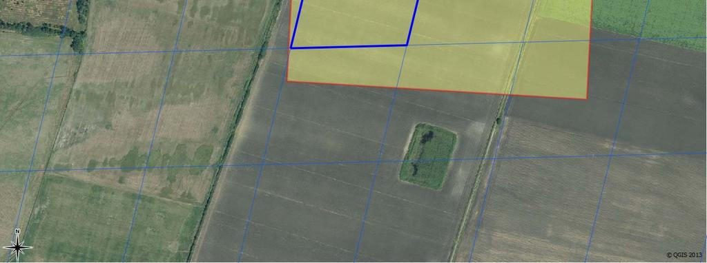
18 Beginning: initial motivation A user wants to detect the date of interventions on agricultural fields Spatial scale: ~ pixel, Time scale: ~ day Band 2 Band 2, QC 4096 (OK) Kristóf, Petrik, Pataki, Kolesár: Satellite data processing and analysis NASA International LCLUC Regional Science Meeting in Central Europe Sopron, Hungary, October


19 Beginning: initial motivation Aqua MODIS land surface reflectance Terra MODIS land surface reflectance Day x+1 Day x+1 Day x Day x 19

20 Beginning: initial motivation Terra & Aqua MODIS, the same day Aqua MODIS Terra MODIS 20
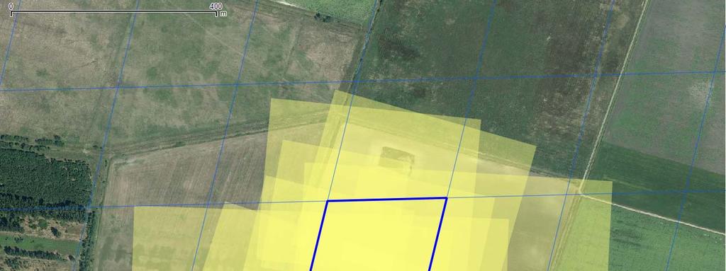
21 Why? MODIS particularities: Gridding artifacts: Data stored in a predefined grid, resampled Average overlap between observations and their respective grid cells less than 30% [Tan et al., RSE 105(2006):98-114] Problems with the raster data model itself: Fixed size and orientation of the cells although the observation dimensions vary across the scene due to the wide field of view (+/- 55 degrees), orientation definitely not N-S The grid cells / pixels do not represent the area where the signal is originated from Kristóf, Petrik, Pataki, Kolesár: Satellite data processing and analysis NASA International LCLUC Regional Science Meeting in Central Europe Sopron, Hungary, October
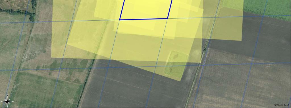
22 MODIS particularities Close to nadir Close to swath edge 22
23 Proposed solution A possible solution would be the spatial and/or temporal compositing and/or filtering, but: loss of resolution and information Our approach: Change data representation Calculate and store observation footprints in polygon format Each polygon represents the respective observation footprint ( real pixel ) sensed during image acquisition Geolocation datasets (MOD/MYD03) contain all necessary info to do this Ground location, dimensions and orientation of each MODIS pixel footprint can be determined from: Latitude, Longitude, Height, Sensor Zenith Angle, Sensor Azimuth Angle, Slant Range Geolocation accuracy: 50 m at 1 sigma at nadir Swath images (MOD/MYD02) or backsampled Surface Reflectance Kristóf, Petrik, Pataki, Kolesár: Satellite data processing and analysis NASA International LCLUC Regional Science Meeting in Central Europe Sopron, Hungary, October


24 Proposed solution What does it look like? kmm 24


25 First results: correlation with SPOT data (NIR band) R 2 = R 2 = R 2 = R 2 = R 2 = R 2 = MODIS at 1 km resolution MODIS at 250 m resolution Kristóf, Petrik, Pataki, Kolesár: Satellite data processing and analysis NASA International LCLUC Regional Science Meeting in Central Europe Sopron, Hungary, October


26 Zoom-in: grid cell vs. observation geometry 26
27 First results Possible application: one-step radiometric normalization of high-resolution imagery by using same-day MODIS surface reflectance. What next? How to handle ever-changing observation geometries as a time series? Kristóf, Petrik, Pataki, Kolesár: Satellite data processing and analysis NASA International LCLUC Regional Science Meeting in Central Europe Sopron, Hungary, October


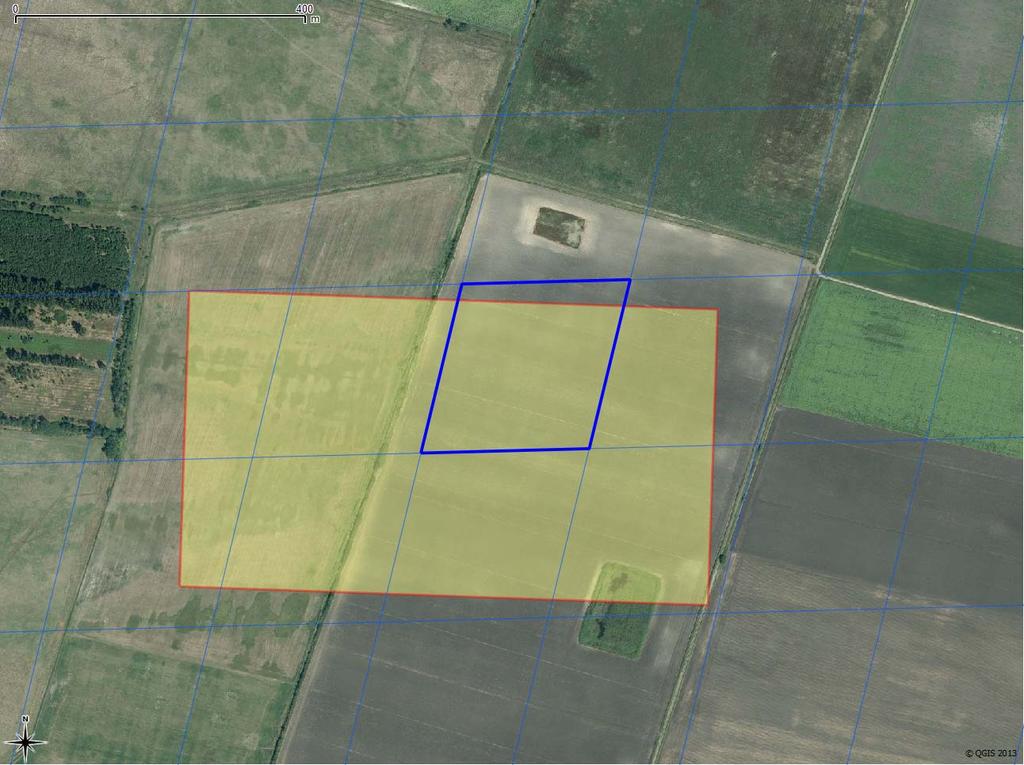
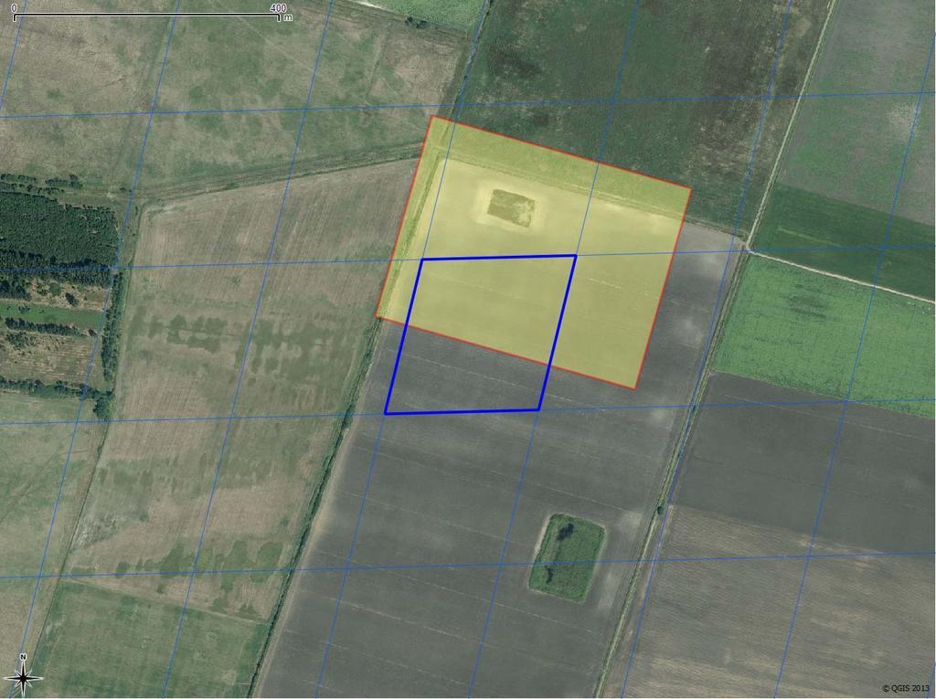
28 Land surface objects of interest: observation units defined a priori Crop map: 512 crop parcels delineated on HR data 28

29 Relevance ( purity ) of each MODIS observation (~pixel) to each observation unit Portion of observation belonging to the given parcel 29

30 Relevance ( purity ) of each MODIS observation (~pixel) to each observation unit Portion of observation belonging to the given parcel 30
31 Only pure observations (above threshold) are selected Green: retained, Red: rejected 31
32 Only pure observations (above threshold) are selected Green: retained, Red: rejected 32
 for")

33 Then, radiometric values are assigned to each observation unit (parcel) for each MODIS overpass Calculation based on area-weigthed mean of retained pixels 33


34 mean_spot mean_grid_simple mean_modis_limit mean_modis mean_spot mean_grid_simple mean_modis mean_modis_limit mean_spot mean_grid_simple mean_modis mean_modis_limit mean_spot mean_grid_simple mean_modis mean_modis_limit mean_spot mean_grid_simple mean_modis mean_modis_limit mean_spot mean_grid_simple atlag_gridbol mean_modis mean_modis_limit mean_spot mean_grid_simple mean_modis mean_modis_limit mean_spot mean_grid_simple mean_modis mean_modis_limit mean_spot mean_grid_simple mean_modis mean_modis_limit mean_spot mean_grid_simple atlag_gridbol mean_modis mean_modis_limit Quality assessment: time-series comparison Quality assessment: time-series comparison


35 Quality measure: number of retained pixels _0945 Green: high, Yellow: medium, Orange: low, Red: zero 35


36 Quality measure: average pixel proportion _0945 Green: high, Yellow: medium, Red: low, White: N/A 36


37 Quality measure: number of retained pixels _1035 Green: high, Yellow: medium, Orange: low, Red: zero 37


38 Quality measure: average pixel proportion _1035 Green: high, Yellow: medium, Red: low, White: N/A 38
39 Conclusions Gridding is a major source of inaccuracy and noise New polygon representation of MODIS observations has significantly increased correlation with same-day highresolution data: better representation of observation geometry Landscape objects delineated a priori can be efficiently used to construct time series Data processing requires more computing power, but the user has full control over the process (thresholds, quality measures, etc.) and can obtain more accurate data with maximal spatial and temporal coverage Kristóf, Petrik, Pataki, Kolesár: Satellite data processing and analysis NASA International LCLUC Regional Science Meeting in Central Europe Sopron, Hungary, October
40 Thank you! Dániel Kristóf head Geoinformation Department Institute of Geodesy, Cartography and Remote Sensing 1149 Budapest, Bosnyák tér 5. phone: cell: kristof.daniel@fomi.hu web: 40
Lecture 6: Multispectral Earth Resource Satellites. The University at Albany Fall 2018 Geography and Planning
 Lecture 6: Multispectral Earth Resource Satellites The University at Albany Fall 2018 Geography and Planning Outline SPOT program and other moderate resolution systems High resolution satellite systems
Introduction to Remote Sensing
 Introduction to Remote Sensing Spatial, spectral, temporal resolutions Image display alternatives Vegetation Indices Image classifications Image change detections Accuracy assessment Satellites & Air-Photos
NON-PHOTOGRAPHIC SYSTEMS: Multispectral Scanners Medium and coarse resolution sensor comparisons: Landsat, SPOT, AVHRR and MODIS
 NON-PHOTOGRAPHIC SYSTEMS: Multispectral Scanners Medium and coarse resolution sensor comparisons: Landsat, SPOT, AVHRR and MODIS CLASSIFICATION OF NONPHOTOGRAPHIC REMOTE SENSORS PASSIVE ACTIVE DIGITAL
Lecture 13: Remotely Sensed Geospatial Data
 Lecture 13: Remotely Sensed Geospatial Data A. The Electromagnetic Spectrum: The electromagnetic spectrum (Figure 1) indicates the different forms of radiation (or simply stated light) emitted by nature.
Remote Sensing Exam 2 Study Guide
 Remote Sensing Exam 2 Study Guide Resolution Analog to digital Instantaneous field of view (IFOV) f ( cone angle of optical system ) Everything in that area contributes to spectral response mixels Sampling
COMPATIBILITY AND INTEGRATION OF NDVI DATA OBTAINED FROM AVHRR/NOAA AND SEVIRI/MSG SENSORS
 COMPATIBILITY AND INTEGRATION OF NDVI DATA OBTAINED FROM AVHRR/NOAA AND SEVIRI/MSG SENSORS Gabriele Poli, Giulia Adembri, Maurizio Tommasini, Monica Gherardelli Department of Electronics and Telecommunication
NORMALIZING ASTER DATA USING MODIS PRODUCTS FOR LAND COVER CLASSIFICATION
 NORMALIZING ASTER DATA USING MODIS PRODUCTS FOR LAND COVER CLASSIFICATION F. Gao a, b, *, J. G. Masek a a Biospheric Sciences Branch, NASA Goddard Space Flight Center, Greenbelt, MD 20771, USA b Earth
MONITORING OF FOREST DAMAGE CAUSED BY GYPSY MOTH IN HUNGARY USING ENVISAT MERIS DATA ( )
") MONITORING OF FOREST DAMAGE CAUSED BY GYPSY MOTH IN HUNGARY USING ENVISAT DATA (2005-2006) G. Nádor, I. László, Zs. Suba, G. Csornai Remote Sensing Centre, Institute of Geodesy Cartography and Remote Sensing
MONITORING OF FOREST DAMAGE CAUSED BY GYPSY MOTH IN HUNGARY USING ENVISAT DATA (2005-2006) G. Nádor, I. László, Zs. Suba, G. Csornai Remote Sensing Centre, Institute of Geodesy Cartography and Remote Sensing
Fundamentals of Remote Sensing
 Climate Variability, Hydrology, and Flooding Fundamentals of Remote Sensing May 19-22, 2015 GEO-Latin American & Caribbean Water Cycle Capacity Building Workshop Cartagena, Colombia 1 Objective To provide
Satellite Remote Sensing: Earth System Observations
 Satellite Remote Sensing: Earth System Observations Land surface Water Atmosphere Climate Ecosystems 1 EOS (Earth Observing System) Develop an understanding of the total Earth system, and the effects of
REMOTE SENSING. Topic 10 Fundamentals of Digital Multispectral Remote Sensing MULTISPECTRAL SCANNERS MULTISPECTRAL SCANNERS
 REMOTE SENSING Topic 10 Fundamentals of Digital Multispectral Remote Sensing Chapter 5: Lillesand and Keifer Chapter 6: Avery and Berlin MULTISPECTRAL SCANNERS Record EMR in a number of discrete portions
Image transformations
 Image transformations Digital Numbers may be composed of three elements: Atmospheric interference (e.g. haze) ATCOR Illumination (angle of reflection) - transforms Albedo (surface cover) Image transformations
Introduction to Remote Sensing Fundamentals of Satellite Remote Sensing. Mads Olander Rasmussen
 Introduction to Remote Sensing Fundamentals of Satellite Remote Sensing Mads Olander Rasmussen (mora@dhi-gras.com) 01. Introduction to Remote Sensing DHI What is remote sensing? the art, science, and technology
9/12/2011. Training Course Remote Sensing Basic Theory & Image Processing Methods September 2011
 Training Course Remote Sensing Basic Theory & Image Processing Methods 19 23 September 2011 Popular Remote Sensing Sensors & their Selection Michiel Damen (September 2011) damen@itc.nl 1 Overview Low resolution
PLANET SURFACE REFLECTANCE PRODUCT
 PLANET SURFACE REFLECTANCE PRODUCT FEBRUARY 2018 SUPPORT@PLANET.COM PLANET.COM VERSION 1.0 TABLE OF CONTENTS 3 Product Description 3 Atmospheric Correction Methodology 5 Product Limitations 6 Product Assessment
- Regridding / Projection - Compositing for Sentinel-2 & Landsat 8 merged products
 - Regridding / Projection - Compositing for Sentinel-2 & Landsat 8 merged products Roy, D.P., Kovalskyy, V., Zhang, H.K., Yan, L., Kumar. S. Geospatial Science Center of Excellence South Dakota State University
Center for Advanced Land Management Information Technologies (CALMIT), School of Natural Resources, University of Nebraska-Lincoln
, School of Natural Resources, University of Nebraska-Lincoln") Geoffrey M. Henebry, Andrés Viña, and Anatoly A. Gitelson Center for Advanced Land Management Information Technologies (CALMIT), School of Natural Resources, University of Nebraska-Lincoln Introduction
Geoffrey M. Henebry, Andrés Viña, and Anatoly A. Gitelson Center for Advanced Land Management Information Technologies (CALMIT), School of Natural Resources, University of Nebraska-Lincoln Introduction
SEN3APP Stakeholder Workshop, Helsinki Yrjö Rauste/VTT Kaj Andersson/VTT Eija Parmes/VTT
 Optical Products from Sentinel-2 and Suomi- NPP/VIIRS SEN3APP Stakeholder Workshop, Helsinki 19.11.2015 Yrjö Rauste/VTT Kaj Andersson/VTT Eija Parmes/VTT Structure of Presentation High-resolution data
From Proba-V to Proba-MVA
 From Proba-V to Proba-MVA Fabrizio Niro ESA Sensor Performances Products and Algorithm (SPPA) ESA UNCLASSIFIED - For Official Use Proba-V extension in the Copernicus era Proba-V was designed with the main
Application of GIS to Fast Track Planning and Monitoring of Development Agenda
 Application of GIS to Fast Track Planning and Monitoring of Development Agenda Radiometric, Atmospheric & Geometric Preprocessing of Optical Remote Sensing 13 17 June 2018 Outline 1. Why pre-process remotely
GeoBase Raw Imagery Data Product Specifications. Edition
 GeoBase Raw Imagery 2005-2010 Data Product Specifications Edition 1.0 2009-10-01 Government of Canada Natural Resources Canada Centre for Topographic Information 2144 King Street West, suite 010 Sherbrooke,
CHARACTERISTICS OF REMOTELY SENSED IMAGERY. Spatial Resolution
 CHARACTERISTICS OF REMOTELY SENSED IMAGERY Spatial Resolution There are a number of ways in which images can differ. One set of important differences relate to the various resolutions that images express.
Introduction to Remote Sensing Part 1
 Introduction to Remote Sensing Part 1 A Primer on Electromagnetic Radiation Digital, Multi-Spectral Imagery The 4 Resolutions Displaying Images Corrections and Enhancements Passive vs. Active Sensors Radar
Spectral Signatures. Vegetation. 40 Soil. Water WAVELENGTH (microns)
") Spectral Signatures % REFLECTANCE VISIBLE NEAR INFRARED Vegetation Soil Water.5. WAVELENGTH (microns). Spectral Reflectance of Urban Materials 5 Parking Lot 5 (5=5%) Reflectance 5 5 5 5 5 Wavelength (nm)
Spectral Signatures % REFLECTANCE VISIBLE NEAR INFRARED Vegetation Soil Water.5. WAVELENGTH (microns). Spectral Reflectance of Urban Materials 5 Parking Lot 5 (5=5%) Reflectance 5 5 5 5 5 Wavelength (nm)
Remote Sensing. The following figure is grey scale display of SPOT Panchromatic without stretching.
 Remote Sensing Objectives This unit will briefly explain display of remote sensing image, geometric correction, spatial enhancement, spectral enhancement and classification of remote sensing image. At
Remote sensing image correction
 Remote sensing image correction Introductory readings remote sensing http://www.microimages.com/documentation/tutorials/introrse.pdf 1 Preprocessing Digital Image Processing of satellite images can be
MRLC 2001 IMAGE PREPROCESSING PROCEDURE
 MRLC 2001 IMAGE PREPROCESSING PROCEDURE The core dataset of the MRLC 2001 database consists of Landsat 7 ETM+ images. Image selection is based on vegetation greenness profiles defined by a multi-year normalized
I nnovative I maging & R esearch I 2. Assessing and Removing AWiFS Systematic Geometric and Atmospheric Effects to Improve Land Cover Change Detection
 I nnovative I maging & esearch Assessing and emoving AWiFS Systematic Geometric and Atmospheric Effects to Improve Land Cover Change Detection Mary Pagnutti obert E. yan Spring LCLUC Science Team Meeting
Remote Sensing Platforms
 Types of Platforms Lighter-than-air Remote Sensing Platforms Free floating balloons Restricted by atmospheric conditions Used to acquire meteorological/atmospheric data Blimps/dirigibles Major role - news
University of Texas at San Antonio EES 5053 Term Project CORRELATION BETWEEN NDVI AND SURFACE TEMPERATURES USING LANDSAT ETM + IMAGERY NEWFEL MAZARI
 University of Texas at San Antonio EES 5053 Term Project CORRELATION BETWEEN NDVI AND SURFACE TEMPERATURES USING LANDSAT ETM + IMAGERY NEWFEL MAZARI Introduction and Objectives The present study is a correlation
typical spectral signatures of photosynthetically active and non-photosynthetically active vegetation (Beeri et al., 2007)
") typical spectral signatures of photosynthetically active and non-photosynthetically active vegetation (Beeri et al., 2007) Xie, Y. et al. J Plant Ecol 2008 1:9-23; doi:10.1093/jpe/rtm005 Copyright restrictions
typical spectral signatures of photosynthetically active and non-photosynthetically active vegetation (Beeri et al., 2007) Xie, Y. et al. J Plant Ecol 2008 1:9-23; doi:10.1093/jpe/rtm005 Copyright restrictions
Update on Landsat Program and Landsat Data Continuity Mission
 Update on Landsat Program and Landsat Data Continuity Mission Dr. Jeffrey Masek LDCM Deputy Project Scientist NASA GSFC, Code 923 November 21, 2002 Draft LDCM Implementation Phase RFP Overview Page 1 Celebrate!
APCAS/10/21 April 2010 ASIA AND PACIFIC COMMISSION ON AGRICULTURAL STATISTICS TWENTY-THIRD SESSION. Siem Reap, Cambodia, April 2010
 APCAS/10/21 April 2010 Agenda Item 8 ASIA AND PACIFIC COMMISSION ON AGRICULTURAL STATISTICS TWENTY-THIRD SESSION Siem Reap, Cambodia, 26-30 April 2010 The Use of Remote Sensing for Area Estimation by Robert
Lesson 3: Working with Landsat Data
 Lesson 3: Working with Landsat Data Lesson Description The Landsat Program is the longest-running and most extensive collection of satellite imagery for Earth. These datasets are global in scale, continuously
Remote Sensing Platforms
 Remote Sensing Platforms Remote Sensing Platforms - Introduction Allow observer and/or sensor to be above the target/phenomena of interest Two primary categories Aircraft Spacecraft Each type offers different
A SYNERGETIC USE OF REMOTE-SENSED DATA TO ASSESS THE EVOLUTION OF BURNT AREA BY WILDFIRES IN PORTUGAL
 A SYNERGETIC USE OF REMOTE-SENSED DATA TO ASSESS THE EVOLUTION OF BURNT AREA BY WILDFIRES IN PORTUGAL Teresa J. Calado and Carlos C. DaCamara CGUL, Faculty of Sciences, University of Lisbon, Campo Grande,
LANDSAT 8 Level 1 Product Performance
 Réf: IDEAS-TN-10-CyclicReport LANDSAT 8 Level 1 Product Performance Cyclic Report Month/Year: May 2015 Date: 25/05/2015 Issue/Rev:1/0 1. Scope of this document On May 30, 2013, data from the Landsat 8
Global Land Survey 2005
 Global Land Survey 2005 Jeff Masek, Shannon Franks, Terry Arvidson NASA GSFC Rachel Headley, Steve Covington USGS EROS April, 2008 1 Global Land Survey (GLS 2005) Follow-on to the GeoCover orthorectified
A map says to you, 'Read me carefully, follow me closely, doubt me not.' It says, 'I am the Earth in the palm of your hand. Without me, you are alone
 A map says to you, 'Read me carefully, follow me closely, doubt me not.' It says, 'I am the Earth in the palm of your hand. Without me, you are alone and lost. Beryl Markham (West With the Night, 1946
Field size estimation, past and future opportunities
 Field size estimation, past and future opportunities Lin Yan & David Roy Geospatial Sciences Center of Excellence South Dakota State University February 13-15 th 2018 Advances in Emerging Technologies
Remote Sensing for Rangeland Applications
 Remote Sensing for Rangeland Applications Jay Angerer Ecological Training June 16, 2012 Remote Sensing The term "remote sensing," first used in the United States in the 1950s by Ms. Evelyn Pruitt of the
Satellite Imagery and Remote Sensing. DeeDee Whitaker SW Guilford High EES & Chemistry
 Satellite Imagery and Remote Sensing DeeDee Whitaker SW Guilford High EES & Chemistry whitakd@gcsnc.com Outline What is remote sensing? How does remote sensing work? What role does the electromagnetic
Multi-Resolution Analysis of MODIS and ASTER Satellite Data for Water Classification
 Corina Alecu, Simona Oancea National Meteorological Administration 97 Soseaua Bucuresti-Ploiesti, 013686, Sector 1, Bucharest Romania corina.alecu@meteo.inmh.ro Emily Bryant Dartmouth Flood Observatory,
Inter-Calibration of the RapidEye Sensors with Landsat 8, Sentinel and SPOT
 Inter-Calibration of the RapidEye Sensors with Landsat 8, Sentinel and SPOT Dr. Andreas Brunn, Dr. Horst Weichelt, Dr. Rene Griesbach, Dr. Pablo Rosso Content About Planet Project Context (Purpose and
Sources of Geographic Information
 Sources of Geographic Information Data properties: Spatial data, i.e. data that are associated with geographic locations Data format: digital (analog data for traditional paper maps) Data Inputs: sampled
Evaluation of FLAASH atmospheric correction. Note. Note no SAMBA/10/12. Authors. Øystein Rudjord and Øivind Due Trier
 Evaluation of FLAASH atmospheric correction Note Note no Authors SAMBA/10/12 Øystein Rudjord and Øivind Due Trier Date 16 February 2012 Norsk Regnesentral Norsk Regnesentral (Norwegian Computing Center,
(Refer Slide Time: 1:28)
") Introduction to Remote Sensing Dr. Arun K Saraf Department of Earth Sciences Indian Institute of Technology Roorkee Lecture 10 Image characteristics and different resolutions in Remote Sensing Hello everyone,
Introduction to Remote Sensing Dr. Arun K Saraf Department of Earth Sciences Indian Institute of Technology Roorkee Lecture 10 Image characteristics and different resolutions in Remote Sensing Hello everyone,
CHAPTER 7: Multispectral Remote Sensing
 CHAPTER 7: Multispectral Remote Sensing REFERENCE: Remote Sensing of the Environment John R. Jensen (2007) Second Edition Pearson Prentice Hall Overview of How Digital Remotely Sensed Data are Transformed
NASA Missions and Products: Update. Garik Gutman, LCLUC Program Manager NASA Headquarters Washington, DC
 NASA Missions and Products: Update Garik Gutman, LCLUC Program Manager NASA Headquarters Washington, DC 1 JPSS-2 (NOAA) SLI-TBD Formulation in 2015 RBI OMPS-Limb [[TSIS-2]] [[TCTE]] Land Monitoring at
CanImage. (Landsat 7 Orthoimages at the 1: Scale) Standards and Specifications Edition 1.0
 Standards and Specifications Edition 1.0") CanImage (Landsat 7 Orthoimages at the 1:50 000 Scale) Standards and Specifications Edition 1.0 Centre for Topographic Information Customer Support Group 2144 King Street West, Suite 010 Sherbrooke, QC
CanImage (Landsat 7 Orthoimages at the 1:50 000 Scale) Standards and Specifications Edition 1.0 Centre for Topographic Information Customer Support Group 2144 King Street West, Suite 010 Sherbrooke, QC
Sentinel-2 Products and Algorithms
 Sentinel-2 Products and Algorithms Ferran Gascon (Sentinel-2 Data Quality Manager) Workshop Preparations for Sentinel 2 in Europe, Oslo 26 November 2014 Sentinel-2 Mission Mission Overview Products and
Recent developments in Deep Blue satellite aerosol data products from NASA GSFC
 Recent developments in Deep Blue satellite aerosol data products from NASA GSFC Andrew M. Sayer, N. Christina Hsu (PI), Corey Bettenhausen, Myeong-Jae Jeong Climate & Radiation Laboratory, NASA Goddard
Sommersemester Prof. Dr. Christoph Kleinn Institut für Waldinventur und Waldwachstum Arbeitsbereich Fernerkundung und Waldinventur.
 Basics of Remote Sensing Some literature references Franklin, SE 2001 Remote Sensing for Sustainable Forest Management Lewis Publishers 407p Lillesand, Kiefer 2000 Remote Sensing and Image Interpretation
ASTER and USGS EROS Emergency Imaging for Hurricane Disasters
 ASTER and USGS EROS Emergency Imaging for Hurricane Disasters By Kenneth A. Duda and Michael Abrams Satellite images have been extremely useful in a variety of emergency response activities, including
remote sensing? What are the remote sensing principles behind these Definition
 Introduction to remote sensing: Content (1/2) Definition: photogrammetry and remote sensing (PRS) Radiation sources: solar radiation (passive optical RS) earth emission (passive microwave or thermal infrared
The availability of cloud free Landsat TM and ETM+ land observations and implications for global Landsat data production
 14475 The availability of cloud free Landsat TM and ETM+ land observations and implications for global Landsat data production *V. Kovalskyy, D. Roy (South Dakota State University) SUMMARY The NASA funded
AT-SATELLITE REFLECTANCE: A FIRST ORDER NORMALIZATION OF LANDSAT 7 ETM+ IMAGES
 AT-SATELLITE REFLECTANCE: A FIRST ORDER NORMALIZATION OF LANDSAT 7 ETM+ IMAGES Chengquan Huang*, Limin Yang, Collin Homer, Bruce Wylie, James Vogelman and Thomas DeFelice Raytheon ITSS, EROS Data Center
Lesson 9: Multitemporal Analysis
 Lesson 9: Multitemporal Analysis Lesson Description Multitemporal change analyses require the identification of features and measurement of their change through time. In this lesson, we will examine vegetation
An Introduction to Geomatics. Prepared by: Dr. Maher A. El-Hallaq خاص بطلبة مساق مقدمة في علم. Associate Professor of Surveying IUG
 An Introduction to Geomatics خاص بطلبة مساق مقدمة في علم الجيوماتكس Prepared by: Dr. Maher A. El-Hallaq Associate Professor of Surveying IUG 1 Airborne Imagery Dr. Maher A. El-Hallaq Associate Professor
GEOMETRIC RECTIFICATION OF EUROPEAN HISTORICAL ARCHIVES OF LANDSAT 1-3 MSS IMAGERY
 GEOMETRIC RECTIFICATION OF EUROPEAN HISTORICAL ARCHIVES OF LANDSAT -3 MSS IMAGERY Torbjörn Westin Satellus AB P.O.Box 427, SE-74 Solna, Sweden tw@ssc.se KEYWORDS: Landsat, MSS, rectification, orbital model
The studies began when the Tiros satellites (1960) provided man s first synoptic view of the Earth s weather systems.
 provided man s first synoptic view of the Earth s weather systems.") Remote sensing of the Earth from orbital altitudes was recognized in the mid-1960 s as a potential technique for obtaining information important for the effective use and conservation of natural resources.
Remote sensing of the Earth from orbital altitudes was recognized in the mid-1960 s as a potential technique for obtaining information important for the effective use and conservation of natural resources.
How to Access Imagery and Carry Out Remote Sensing Analysis Using Landsat Data in a Browser
 How to Access Imagery and Carry Out Remote Sensing Analysis Using Landsat Data in a Browser Including Introduction to Remote Sensing Concepts Based on: igett Remote Sensing Concept Modules and GeoTech
DISTINGUISHING URBAN BUILT-UP AND BARE SOIL FEATURES FROM LANDSAT 8 OLI IMAGERY USING DIFFERENT DEVELOPED BAND INDICES
 DISTINGUISHING URBAN BUILT-UP AND BARE SOIL FEATURES FROM LANDSAT 8 OLI IMAGERY USING DIFFERENT DEVELOPED BAND INDICES Mark Daryl C. Janiola (1), Jigg L. Pelayo (1), John Louis J. Gacad (1) (1) Central
Preparing Remote Sensing Data for Natural Resources Mapping (image enhancement, rectifications )
") Preparing Remote Sensing Data for Natural Resources Mapping (image enhancement, rectifications ) Why is this important What are the major approaches Examples of digital image enhancement Follow up exercises
Preparing Remote Sensing Data for Natural Resources Mapping (image enhancement, rectifications ) Why is this important What are the major approaches Examples of digital image enhancement Follow up exercises
Some Basic Concepts of Remote Sensing. Lecture 2 August 31, 2005
 Some Basic Concepts of Remote Sensing Lecture 2 August 31, 2005 What is remote sensing Remote Sensing: remote sensing is science of acquiring, processing, and interpreting images and related data that
IKONOS High Resolution Multispectral Scanner Sensor Characteristics
 High Spatial Resolution and Hyperspectral Scanners IKONOS High Resolution Multispectral Scanner Sensor Characteristics Launch Date View Angle Orbit 24 September 1999 Vandenberg Air Force Base, California,
GIS Data Collection. Remote Sensing
 GIS Data Collection Remote Sensing Data Collection Remote sensing Introduction Concepts Spectral signatures Resolutions: spectral, spatial, temporal Digital image processing (classification) Other systems
TEMPORAL ANALYSIS OF MULTI EPOCH LANDSAT GEOCOVER IMAGES IN ZONGULDAK TESTFIELD
 TEMPORAL ANALYSIS OF MULTI EPOCH LANDSAT GEOCOVER IMAGES IN ZONGULDAK TESTFIELD Şahin, H. a*, Oruç, M. a, Büyüksalih, G. a a Zonguldak Karaelmas University, Zonguldak, Turkey - (sahin@karaelmas.edu.tr,
PILOTING A DECISION SUPPORT TOOL (DST) FOR MAPPING CYANOBACTERIAL HARMFUL ALGAL BLOOMS (CHABS) TO SUPPORT PUBLIC HEALTH AND RESOURCE MANAGEMENT.
 FOR MAPPING CYANOBACTERIAL HARMFUL ALGAL BLOOMS (CHABS) TO SUPPORT PUBLIC HEALTH AND RESOURCE MANAGEMENT.") PILOTING A DECISION SUPPORT TOOL (DST) FOR MAPPING CYANOBACTERIAL HARMFUL ALGAL BLOOMS (CHABS) TO SUPPORT PUBLIC HEALTH AND RESOURCE MANAGEMENT. Nathan Torbick, Applied Geosolutions Scott Stoodley, Director,
PILOTING A DECISION SUPPORT TOOL (DST) FOR MAPPING CYANOBACTERIAL HARMFUL ALGAL BLOOMS (CHABS) TO SUPPORT PUBLIC HEALTH AND RESOURCE MANAGEMENT. Nathan Torbick, Applied Geosolutions Scott Stoodley, Director,
Advanced satellite image fusion techniques for estimating high resolution Land Surface Temperature time series
 COMECAP 2014 e-book of proceedings vol. 2 Page 267 Advanced satellite image fusion techniques for estimating high resolution Land Surface Temperature time series Mitraka Z., Chrysoulakis N. Land Surface
Lecture 7 Earth observation missions
 Remote sensing for agricultural applications: principles and methods (2013-2014) Instructor: Prof. Tao Cheng (tcheng@njau.edu.cn). Nanjing Agricultural University Lecture 7 Earth observation missions May
MERIS instrument. Muriel Simon, Serco c/o ESA
 MERIS instrument Muriel Simon, Serco c/o ESA Workshop on Sustainable Development in Mountain Areas of Andean Countries Mendoza, Argentina, 26-30 November 2007 ENVISAT MISSION 2 Mission Chlorophyll case
Introduction of Satellite Remote Sensing
 Introduction of Satellite Remote Sensing Spatial Resolution (Pixel size) Spectral Resolution (Bands) Resolutions of Remote Sensing 1. Spatial (what area and how detailed) 2. Spectral (what colors bands)
Land Cover Analysis to Determine Areas of Clear-cut and Forest Cover in Olney, Montana. Geob 373 Remote Sensing. Dr Andreas Varhola, Kathry De Rego
 1 Land Cover Analysis to Determine Areas of Clear-cut and Forest Cover in Olney, Montana Geob 373 Remote Sensing Dr Andreas Varhola, Kathry De Rego Zhu an Lim (14292149) L2B 17 Apr 2016 2 Abstract Montana
Data acquisition and access for the Congo Basin
 MRV Joint Workshop 22-24 June 2010, Guadalajara, Jalisco Mexico Data acquisition and access for the Congo Basin Landing Mané 1, Michael Brady 2, Chris Justice 3 and Alice Altstatt 3 1) Satellite Observatory
Geo/SAT 2 INTRODUCTION TO REMOTE SENSING
 Geo/SAT 2 INTRODUCTION TO REMOTE SENSING Paul R. Baumann, Professor Emeritus State University of New York College at Oneonta Oneonta, New York 13820 USA COPYRIGHT 2008 Paul R. Baumann Introduction Remote
An Introduction to Remote Sensing & GIS. Introduction
 An Introduction to Remote Sensing & GIS Introduction Remote sensing is the measurement of object properties on Earth s surface using data acquired from aircraft and satellites. It attempts to measure something
Creating Reprojected True Color MODIS Images: A Tutorial
 Creating Reprojected True Color MODIS Images: A Tutorial Liam Gumley Space Science and Engineering Center, University of Wisconsin-Madison Jacques Descloitres and Jeffrey Schmaltz MODIS Rapid Response
Progress Report. NASA Headquarters Earth Science Division Land Cover/Land Use Change Program
 Progress Report NASA Headquarters Earth Science Division Land Cover/Land Use Change Program Comparison of the IRS Advanced Wide Field Sensor to Landsat for Supplying General Land Cover Land Use Change
White Paper. Medium Resolution Images and Clutter From Landsat 7 Sources. Pierre Missud
 White Paper Medium Resolution Images and Clutter From Landsat 7 Sources Pierre Missud Medium Resolution Images and Clutter From Landsat7 Sources Page 2 of 5 Introduction Space technologies have long been
Using Freely Available. Remote Sensing to Create a More Powerful GIS
 Using Freely Available Government Data and Remote Sensing to Create a More Powerful GIS All rights reserved. ENVI, E3De, IAS, and IDL are trademarks of Exelis, Inc. All other marks are the property of
Remote Sensing Instruction Laboratory
 Laboratory Session 217513 Geographic Information System and Remote Sensing - 1 - Remote Sensing Instruction Laboratory Assist.Prof.Dr. Weerakaset Suanpaga Department of Civil Engineering, Faculty of Engineering
Govt. Engineering College Jhalawar Model Question Paper Subject- Remote Sensing & GIS
 Govt. Engineering College Jhalawar Model Question Paper Subject- Remote Sensing & GIS Time: Max. Marks: Q1. What is remote Sensing? Explain the basic components of a Remote Sensing system. Q2. What is
Using IRS Products to Recover 7ETM + Defective Images
 American Journal of Applied Sciences 5 (6): 618-625, 2008 ISSN 1546-9239 2008 Science Publications Using IRS Products to Recover 7ETM + Defective Images 1 Mobasheri Mohammad Reza and 2 Sadeghi Naeini Ali
Aral Sea profile Selection of area 24 February April May 1998
 250 km Aral Sea profile 1960 1960 1985 1986 1987 1988 1989 1990 1991 1992 1993 1994 1995 1996 1997 1998 2010? Selection of area Area of interest Kzyl-Orda Dried seabed 185 km Syrdarya river Aral Sea Salt
INTERNATIONAL JOURNAL OF ENVIRONMENTAL SCIENCES Volume 6, No 5, Copyright by the authors - Licensee IPA- Under Creative Commons license 3.
 INTERNATIONAL JOURNAL OF ENVIRONMENTAL SCIENCES Volume 6, No 5, 2016 Copyright by the authors - Licensee IPA- Under Creative Commons license 3.0 Research article ISSN 0976 4402 Normalised difference water
Summary. Introduction. Remote Sensing Basics. Selecting a Remote Sensing Product
 K. Dalsted, J.F. Paris, D.E. Clay, S.A. Clay, C.L. Reese, and J. Chang SSMG-40 Selecting the Appropriate Satellite Remote Sensing Product for Precision Farming Summary Given the large number of satellite
Land Remote Sensing Lab 4: Classication and Change Detection Assigned: October 15, 2017 Due: October 27, Classication
 Name: Land Remote Sensing Lab 4: Classication and Change Detection Assigned: October 15, 2017 Due: October 27, 2017 In this lab, you will generate several gures. Please sensibly name these images, save
Separation of crop and vegetation based on Digital Image Processing
 Separation of crop and vegetation based on Digital Image Processing Mayank Singh Sakla 1, Palak Jain 2 1 M.TECH GEOMATICS student, CEPT UNIVERSITY 2 M.TECH GEOMATICS student, CEPT UNIVERSITY Word Limit
Inter comparison of Terra and Aqua MODIS Reflective Solar Bands Using Suomi NPP VIIRS
 Inter comparison of Terra and Aqua Reflective Solar Bands Using Suomi NPP VIIRS Slawomir Blonski, * Changyong Cao, Sirish Uprety, ** and Xi Shao * NOAA NESDIS Center for Satellite Applications and Research
DEVELOPMENT OF A NEW SOUTH AFRICAN LAND-COVER DATASET USING AUTOMATED MAPPING TECHINQUES. Mark Thompson 1
 DEVELOPMENT OF A NEW SOUTH AFRICAN LAND-COVER DATASET USING AUTOMATED MAPPING TECHINQUES. Mark Thompson 1 1 GeoTerraImage Pty Ltd, Pretoria, South Africa Abstract This talk will discuss the development
Spatial Analyst is an extension in ArcGIS specially designed for working with raster data.
 Spatial Analyst is an extension in ArcGIS specially designed for working with raster data. 1 Do you remember the difference between vector and raster data in GIS? 2 In Lesson 2 you learned about the difference
Monitoring agricultural plantations with remote sensing imagery
 MPRA Munich Personal RePEc Archive Monitoring agricultural plantations with remote sensing imagery Camelia Slave and Anca Rotman University of Agronomic Sciences and Veterinary Medicine - Bucharest Romania,
WGISS-42 USGS Agency Report
 WGISS-42 USGS Agency Report U.S. Department of the Interior U.S. Geological Survey Kristi Kline USGS EROS Center Major Activities Landsat Archive/Distribution Changes Land Change Monitoring, Assessment,
Remote Sensing. Measuring an object from a distance. For GIS, that means using photographic or satellite images to gather spatial data
 Remote Sensing Measuring an object from a distance For GIS, that means using photographic or satellite images to gather spatial data Remote Sensing measures electromagnetic energy reflected or emitted
MULTIRESOLUTION SPOT-5 DATA FOR BOREAL FOREST MONITORING
 MULTIRESOLUTION SPOT-5 DATA FOR BOREAL FOREST MONITORING M. G. Rosengren, E. Willén Metria Miljöanalys, P.O. Box 24154, SE-104 51 Stockholm, Sweden - (mats.rosengren, erik.willen)@lm.se KEY WORDS: Remote
The techniques with ERDAS IMAGINE include:
 The techniques with ERDAS IMAGINE include: 1. Data correction - radiometric and geometric correction 2. Radiometric enhancement - enhancing images based on the values of individual pixels 3. Spatial enhancement
Upscaling UAV-borne high resolution vegetation index to satellite resolutions over a vineyard
 22nd International Congress on Modelling and Simulation, Hobart, Tasmania, Australia, 3 to 8 December 2017 mssanz.org.au/modsim2017 Upscaling UAV-borne high resolution vegetation index to satellite resolutions
National Aeronautics and Space Administration. Landsat Update. Jeff Masek, NASA GSFC Jim Irons, NASA GSFC. April 3, 2012 LCLUC Meeting.
 National Aeronautics and Space Administration Landsat Update Jeff Masek, NASA GSFC Jim Irons, NASA GSFC April 3, 2012 LCLUC Meeting www.nasa.gov Agenda Landsat-5/7 Update LDCM / Landsat-8 Mission Status
Part I. The Importance of Image Registration for Remote Sensing
 Part I The Importance of Image Registration for Remote Sensing 1 Introduction jacqueline le moigne, nathan s. netanyahu, and roger d. eastman Despite the importance of image registration to data integration