Preparing Remote Sensing Data for Natural Resources Mapping (image enhancement, rectifications )
|
|
|
- Ada Scarlett Shaw
- 6 years ago
- Views:
Transcription
1 Preparing Remote Sensing Data for Natural Resources Mapping (image enhancement, rectifications ) Why is this important What are the major approaches Examples of digital image enhancement Follow up exercises Image Enhancement Image enhancement is the process of making an image more interpretable for a particular application. Enhancement makes important features of raw remotely sensed data more interpretable to human eyes. Enhancement techniques are often used instead of classification techniques for feature extraction - studying and locating areas and objects on the ground and deriving useful information from images. 1
2 Image enhancement techniques in ERDAS IMAGINE include: 1. Data correction - radiometric and geometric correction 2. Radiometric enhancement - enhancing images based on the values of individual pixels 3. Spatial enhancement - enhancing images based on the values of individual and neighboring pixels 4. Spectral enhancement - enhancing images by transforming the values of each pixel on a multi-band basis Image enhancement may be performed temporarily when an image is displayed, or permanently on the image data in the data file. An example of simple image Reduction (zooming out): 2


3 Image enhancement may be performed temporarily when an image is displayed, or permanently on the image data in the data file. An example of image magnification (Zooming in) 3
4 Radiometric Enhancement Radiometric enhancement deals with individual values of pixels in the image. Radiometric enhancement of a multi-band image can be considered as a series of independent, single-band enhancement. Radiometric enhancement usually does not bring out the contrast of every pixel in an image. Contrast can be lost between some pixels, while gained on others. 4


5 Image Enhancement: Example: Displaying an image without applying stretch Visually Enhanced Image Original Image Linear Contrast Stretch A linear contrast stretch is a simple way to improve the visible contrast of an image. It is often necessary to contrast-stretch raw image data, so that darker pixels can be seen on the display. 5
.")
.")
6 Linear Contrast Stretch In most raw data, data file values fall within a narrow range usually a range much narrower than the display device is capable of displaying. That range can be expanded to utilize the total range of the display device (usually 0 to 255). Linear Contrast Stretch Contrast enhancement (or contrast stretching) expands the original input brightness values to make use of the total range or sensitivity of the input device (e.g., output level of 0-255). Linear contrast enhancement is best applied to remotely sensed images with Gaussian or near-gaussian histograms. 6
7 Min.-Max. Contrast Stretch +1 Standard Deviation Contrast Stretch Linear Contrast Enhancement: Minimum- Maximum Contrast Stretch where: -BV in is the original input brightness value - quant k is the range of the brightness values that can be displayed on the CRT (e.g., 255), min k is the minimum value in the image, max k is the maximum value in the image, and BV out is the output brightness value 7
8 Linear Contrast Enhancement: Minimum- Maximum Contrast Stretch All other original brightness values between 5 and 104 are linearly distributed between 0 and 255. Original Min.-Max. Contrast Stretch +1 Standard Deviation Contrast Stretch Minimum-maximum +1 standard deviation 8
9 Piecewise Linear Contrast Stretch A piecewise linear contrast stretch allows for the enhancement of a specific portion of data by dividing the lookup table into three sections: low, middle, and high. Or, the selective pieces of the histogram are linearly contrast stretched. It enables the user to create a number of straight line segments which can simulate a curve. The user can enhance the contrast or brightness of any section in a single color at a time. This technique is very useful for enhancing image areas in shadow or other areas of low contrast. A lookup table is an ordered set of numbers, which is used to perform a function on a set of input values. To display or print an image, lookup tables translate file values into brightness values. Input Output 30 > 0 31 > > > > > > > > > > 255 9
 across the entire image.")
10 Nonlinear Contrast Stretch A nonlinear spectral enhancement can be used to gradually increase or decrease contrast over a range, instead of applying the same amount of contrast (slope) across the entire image. Usually, nonlinear enhancements bring out the contrast in one range while decreasing the contrast in other ranges. 10
 Histogram matching is useful for matching data of the same or adjacent scenes that were scanned on separate days, or are slightly different because of")
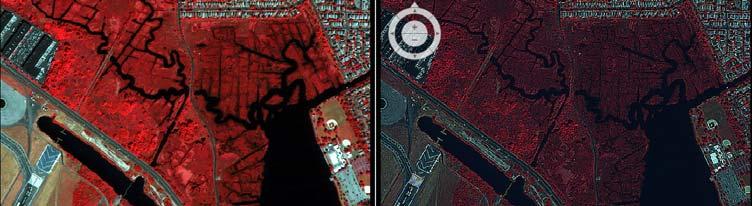
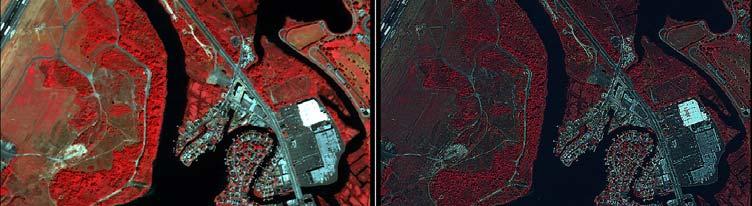
11 Histogram Matching Histogram matching is the process of determining a lookup table that will convert the histogram of one image to resemble the histogram of another. Landsat TM (August 1995 and 1998, Bands 4,3,2) Histogram matching is useful for matching data of the same or adjacent scenes that were scanned on separate days, or are slightly different because of sun angle or atmospheric effects. This is especially useful for mosaicking or change detection. 11
12 Histogram Matching To achieve good results with histogram matching, the two input images should have similar characteristics: 1. The general shape of the histogram curves should be similar. 2. Relative dark and light features in the image should be the same. 3. For some applications, the spatial resolution of the data should be the same. 4. The relative distributions of land covers should be about the same, even when matching scenes that are not of the same area. If one image has clouds and the other does not, then the clouds should be removed before matching the histograms. 12


13 Resolution Merge Resolution merge resamples low spatial resolution data to a higher spatial resolution based on the finer spatial information provider and retains spectral characteristics carried by the original data. For example, Landsat TM sensors have six spectral bands with 30-m spatial resolution and a panchromatic band with 10-m spatial resolution. Integrating the two types of images can yield a new dataset with 10-m resolution and retain the spectral characteristics of the sensors. Resolution Merge 13
14 Resolution Merge 14

15 Spatial Enhancement While radiometric enhancements operate on each pixel individually, spatial enhancement modifies pixel values based on the values of surrounding pixels. A characteristics of remotely sensed images is a parameter called spatial frequency, defined as the number of changes in brightness value per unit distance for any particular part of an image. Spatial enhancement deals largely with spatial frequency. Spatial Enhancement Spatial frequency is defined as the number of changes in brightness value per unit distance for any particular part of an image 1. Zero spatial frequency - a flat image, in which every pixel has the same value 2. Low spatial frequency - an image consisting of a smoothly varying gray scale 3. Highest spatial frequency - an image consisting of a checkerboard of black and white pixels 15
16 Spatial Enhancement Spatial frequency in remotely sensed imagery may be enhanced or subdued using two different approaches: - Spatial convolution filtering based primarily on the use of convolution masks, and - Fourier analysis which mathematically separates an image into its spatial frequency components. Filtering is a broad term, referring to the altering of spatial or spectral features for image enhancement. Convolution filtering is one method of spatial filtering. Convolution Filtering Convolution filtering is the process of averaging small sets of pixels across an image. Convolution filtering is used to change the spatial frequency characteristics of an image. 16


17 Convolution filtering is the process of averaging small sets of pixels across an image. Convolution filtering is used to change the spatial frequency characteristics of an image. low-pass filtering Convolution filtering is the process of averaging small sets of pixels across an image. Convolution filtering is used to change the spatial frequency characteristics of an image. High-pass filtering 17

18 A Spatial convolution kernel is a matrix of numbers that is used to average the value of each pixel with the values of surrounding pixels in a particular way. The numbers in the matrix serve to weight this average toward particular pixels. These numbers are called coefficients, because they are used as such in the mathematical equations. The size of the neighborhood convolution mask or kernel (n) is usually 3 x 3, 5 x 5, 7 x 7, or 9 x 9. An example of 3 x 3 kernel: c1 c2 c3 Mask template = c4 c5 c6 c7 c8 c Spatial Convolution Filtering The coefficients, c 1, in the mask are multiplied by the following individual brightness values (BV i ) in the input image: c 1 x BV 1 c 2 x BV 2 c 3 x BV 3 Mask template = c 4 x BV 4 c 5 x BV 5 c 6 x BV 6 c 7 x BV 7 c 8 x BV 8 c 9 x BV 9 The primary input pixel under investigation at any one time is BV 5 = BV i,j 18
19 Various Convolution Mask Kernels Low-pass filtering: is to de-emphasize or block the high spatial frequency details. 19
20 Spatial Convolution Filtering: Low Frequency Filter The simplest low-pass filter evaluates a particular input pixel brightness value, BV in, and the pixels surrounding the input pixel, and output a new brightness value, BV out, that is the mean of this convolution Low-pass filter: 170 (Averaged) 20

21 Low Pass Filter High-pass filtering: is to remove the slowly varying components and enhance the high-frequency local variations. 21
22 Spatial Convolution Filtering: High-pass (Frequency) Filter One high-frequency filter (HFF 5,out ) is computed by subtracting the output of the low-frequency filter (LFF 5,out ) from twice the value of the original central pixel value, BV 5 : 22
23 Spatial Convolution Filtering: Edge Enhancement For many remote sensing Earth science applications, the most valuable information that may be derived from an image is contained in the edges surrounding various objects of interest. Edge enhancement delineates these edges and makes the shapes and details comprising the image more conspicuous and perhaps easier to analyze. Edges may be enhanced using either linear or nonlinear edge enhancement techniques. 23
24 Compass gradient masks may be used to perform two-dimensional, discrete differentiation directional edge enhancement. Spatial Convolution Filtering: Directional First- Difference Linear Edge Enhancement The result of the subtraction can be either negative or possible, therefore a constant, K (usually 127) is added to make all values positive and centered between 0 and
Image enhancement. Introduction to Photogrammetry and Remote Sensing (SGHG 1473) Dr. Muhammad Zulkarnain Abdul Rahman
 Dr. Muhammad Zulkarnain Abdul Rahman") Image enhancement Introduction to Photogrammetry and Remote Sensing (SGHG 1473) Dr. Muhammad Zulkarnain Abdul Rahman Image enhancement Enhancements are used to make it easier for visual interpretation
Image enhancement Introduction to Photogrammetry and Remote Sensing (SGHG 1473) Dr. Muhammad Zulkarnain Abdul Rahman Image enhancement Enhancements are used to make it easier for visual interpretation
Mod. 2 p. 1. Prof. Dr. Christoph Kleinn Institut für Waldinventur und Waldwachstum Arbeitsbereich Fernerkundung und Waldinventur
 Histograms of gray values for TM bands 1-7 for the example image - Band 4 and 5 show more differentiation than the others (contrast=the ratio of brightest to darkest areas of a landscape). - Judging from
University of Technology Building & Construction Department / Remote Sensing & GIS lecture
 8. Image Enhancement 8.1 Image Reduction and Magnification. 8.2 Transects (Spatial Profile) 8.3 Spectral Profile 8.4 Contrast Enhancement 8.4.1 Linear Contrast Enhancement 8.4.2 Non-Linear Contrast Enhancement
GE 113 REMOTE SENSING. Topic 7. Image Enhancement
 GE 113 REMOTE SENSING Topic 7. Image Enhancement Lecturer: Engr. Jojene R. Santillan jrsantillan@carsu.edu.ph Division of Geodetic Engineering College of Engineering and Information Technology Caraga State
CoE4TN4 Image Processing. Chapter 3: Intensity Transformation and Spatial Filtering
 CoE4TN4 Image Processing Chapter 3: Intensity Transformation and Spatial Filtering Image Enhancement Enhancement techniques: to process an image so that the result is more suitable than the original image
Reading Instructions Chapters for this lecture. Computer Assisted Image Analysis Lecture 2 Point Processing. Image Processing
 1/34 Reading Instructions Chapters for this lecture 2/34 Computer Assisted Image Analysis Lecture 2 Point Processing Anders Brun (anders@cb.uu.se) Centre for Image Analysis Swedish University of Agricultural
Digital Image Processing
 Digital Image Processing Part 2: Image Enhancement Digital Image Processing Course Introduction in the Spatial Domain Lecture AASS Learning Systems Lab, Teknik Room T26 achim.lilienthal@tech.oru.se Course
Enhancement of Multispectral Images and Vegetation Indices
 Enhancement of Multispectral Images and Vegetation Indices ERDAS Imagine 2016 Description: We will use ERDAS Imagine with multispectral images to learn how an image can be enhanced for better interpretation.
Prof. Vidya Manian Dept. of Electrical and Comptuer Engineering
 Image Processing Intensity Transformations Chapter 3 Prof. Vidya Manian Dept. of Electrical and Comptuer Engineering INEL 5327 ECE, UPRM Intensity Transformations 1 Overview Background Basic intensity
Digital Image Processing
 Digital Image Processing 1 Patrick Olomoshola, 2 Taiwo Samuel Afolayan 1,2 Surveying & Geoinformatic Department, Faculty of Environmental Sciences, Rufus Giwa Polytechnic, Owo. Nigeria Abstract: This paper
SECTION I - CHAPTER 2 DIGITAL IMAGING PROCESSING CONCEPTS
 RADT 3463 - COMPUTERIZED IMAGING Section I: Chapter 2 RADT 3463 Computerized Imaging 1 SECTION I - CHAPTER 2 DIGITAL IMAGING PROCESSING CONCEPTS RADT 3463 COMPUTERIZED IMAGING Section I: Chapter 2 RADT
TDI2131 Digital Image Processing
 TDI2131 Digital Image Processing Image Enhancement in Spatial Domain Lecture 3 John See Faculty of Information Technology Multimedia University Some portions of content adapted from Zhu Liu, AT&T Labs.
The techniques with ERDAS IMAGINE include:
 The techniques with ERDAS IMAGINE include: 1. Data correction - radiometric and geometric correction 2. Radiometric enhancement - enhancing images based on the values of individual pixels 3. Spatial enhancement
Spatial Analyst is an extension in ArcGIS specially designed for working with raster data.
 Spatial Analyst is an extension in ArcGIS specially designed for working with raster data. 1 Do you remember the difference between vector and raster data in GIS? 2 In Lesson 2 you learned about the difference
IMAGE ENHANCEMENT IN SPATIAL DOMAIN
 A First Course in Machine Vision IMAGE ENHANCEMENT IN SPATIAL DOMAIN By: Ehsan Khoramshahi Definitions The principal objective of enhancement is to process an image so that the result is more suitable
Non Linear Image Enhancement
 Non Linear Image Enhancement SAIYAM TAKKAR Jaypee University of information technology, 2013 SIMANDEEP SINGH Jaypee University of information technology, 2013 Abstract An image enhancement algorithm based
LAB MANUAL SUBJECT: IMAGE PROCESSING BE (COMPUTER) SEM VII
 SEM VII") LAB MANUAL SUBJECT: IMAGE PROCESSING BE (COMPUTER) SEM VII IMAGE PROCESSING INDEX CLASS: B.E(COMPUTER) SR. NO SEMESTER:VII TITLE OF THE EXPERIMENT. 1 Point processing in spatial domain a. Negation of an
LAB MANUAL SUBJECT: IMAGE PROCESSING BE (COMPUTER) SEM VII IMAGE PROCESSING INDEX CLASS: B.E(COMPUTER) SR. NO SEMESTER:VII TITLE OF THE EXPERIMENT. 1 Point processing in spatial domain a. Negation of an
Remote sensing image correction
 Remote sensing image correction Introductory readings remote sensing http://www.microimages.com/documentation/tutorials/introrse.pdf 1 Preprocessing Digital Image Processing of satellite images can be
Using QuickBird Imagery in ESRI Software Products
 Using QuickBird Imagery in ESRI Software Products TABLE OF CONTENTS 1. Introduction...2 Purpose Scope Image Stretching Color Guns 2. Imagery Usage Instructions...4 ArcView 3.x...4 ArcGIS...7 i Using QuickBird
Image interpretation and analysis
 Image interpretation and analysis Grundlagen Fernerkundung, Geo 123.1, FS 2014 Lecture 7a Rogier de Jong Michael Schaepman Why are snow, foam, and clouds white? Why are snow, foam, and clouds white? Today
Application of GIS to Fast Track Planning and Monitoring of Development Agenda
 Application of GIS to Fast Track Planning and Monitoring of Development Agenda Radiometric, Atmospheric & Geometric Preprocessing of Optical Remote Sensing 13 17 June 2018 Outline 1. Why pre-process remotely
Image Processing Lecture 4
 Image Enhancement Image enhancement aims to process an image so that the output image is more suitable than the original. It is used to solve some computer imaging problems, or to improve image quality.
CHARACTERISTICS OF REMOTELY SENSED IMAGERY. Radiometric Resolution
 CHARACTERISTICS OF REMOTELY SENSED IMAGERY Radiometric Resolution There are a number of ways in which images can differ. One set of important differences relate to the various resolutions that images express.
CanImage. (Landsat 7 Orthoimages at the 1: Scale) Standards and Specifications Edition 1.0
 Standards and Specifications Edition 1.0") CanImage (Landsat 7 Orthoimages at the 1:50 000 Scale) Standards and Specifications Edition 1.0 Centre for Topographic Information Customer Support Group 2144 King Street West, Suite 010 Sherbrooke, QC
CanImage (Landsat 7 Orthoimages at the 1:50 000 Scale) Standards and Specifications Edition 1.0 Centre for Topographic Information Customer Support Group 2144 King Street West, Suite 010 Sherbrooke, QC
Remote Sensing. The following figure is grey scale display of SPOT Panchromatic without stretching.
 Remote Sensing Objectives This unit will briefly explain display of remote sensing image, geometric correction, spatial enhancement, spectral enhancement and classification of remote sensing image. At
Frequency Domain Enhancement
 Tutorial Report Frequency Domain Enhancement Page 1 of 21 Frequency Domain Enhancement ESE 558 - DIGITAL IMAGE PROCESSING Tutorial Report Instructor: Murali Subbarao Written by: Tutorial Report Frequency
Digital Image Processing
 Digital Image Processing Lecture # 5 Image Enhancement in Spatial Domain- I ALI JAVED Lecturer SOFTWARE ENGINEERING DEPARTMENT U.E.T TAXILA Email:: ali.javed@uettaxila.edu.pk Office Room #:: 7 Presentation
ECC419 IMAGE PROCESSING
 ECC419 IMAGE PROCESSING INTRODUCTION Image Processing Image processing is a subclass of signal processing concerned specifically with pictures. Digital Image Processing, process digital images by means
CSE 564: Scientific Visualization
 CSE 564: Scientific Visualization Lecture 5: Image Processing Klaus Mueller Stony Brook University Computer Science Department Klaus Mueller, Stony Brook 2003 Image Processing Definitions Purpose: - enhance
DIGITAL IMAGE PROCESSING (COM-3371) Week 2 - January 14, 2002
 Week 2 - January 14, 2002") DIGITAL IMAGE PROCESSING (COM-3371) Week 2 - January 14, 22 Topics: Human eye Visual phenomena Simple image model Image enhancement Point processes Histogram Lookup tables Contrast compression and stretching
DIGITAL IMAGE PROCESSING (COM-3371) Week 2 - January 14, 22 Topics: Human eye Visual phenomena Simple image model Image enhancement Point processes Histogram Lookup tables Contrast compression and stretching
Last Lecture. Lecture 2, Point Processing GW , & , Ida-Maria Which image is wich channel?
 Last Lecture Lecture 2, Point Processing GW 2.6-2.6.4, & 3.1-3.4, Ida-Maria Ida.sintorn@it.uu.se Digitization -sampling in space (x,y) -sampling in amplitude (intensity) How often should you sample in
Abstract Quickbird Vs Aerial photos in identifying man-made objects
 Abstract Quickbird Vs Aerial s in identifying man-made objects Abdullah Mah abdullah.mah@aramco.com Remote Sensing Group, emap Division Integrated Solutions Services Department (ISSD) Saudi Aramco, Dhahran
Table of contents. Vision industrielle 2002/2003. Local and semi-local smoothing. Linear noise filtering: example. Convolution: introduction
 Table of contents Vision industrielle 2002/2003 Session - Image Processing Département Génie Productique INSA de Lyon Christian Wolf wolf@rfv.insa-lyon.fr Introduction Motivation, human vision, history,
Digital database creation of historical Remote Sensing Satellite data from Film Archives A case study
 Digital database creation of historical Remote Sensing Satellite data from Film Archives A case study N.Ganesh Kumar +, E.Venkateswarlu # Product Quality Control, Data Processing Area, NRSA, Hyderabad.
Remote Sensing 4113 Lab 08: Filtering and Principal Components Mar. 28, 2018
 Remote Sensing 4113 Lab 08: Filtering and Principal Components Mar. 28, 2018 In this lab we will explore Filtering and Principal Components analysis. We will again use the Aster data of the Como Bluffs
Image Enhancement in spatial domain. Digital Image Processing GW Chapter 3 from Section (pag 110) Part 2: Filtering in spatial domain
 Part 2: Filtering in spatial domain") Image Enhancement in spatial domain Digital Image Processing GW Chapter 3 from Section 3.4.1 (pag 110) Part 2: Filtering in spatial domain Mask mode radiography Image subtraction in medical imaging 2 Range
Image Enhancement in spatial domain Digital Image Processing GW Chapter 3 from Section 3.4.1 (pag 110) Part 2: Filtering in spatial domain Mask mode radiography Image subtraction in medical imaging 2 Range
Part I Feature Extraction (1) Image Enhancement. CSc I6716 Spring Local, meaningful, detectable parts of the image.
 Image Enhancement. CSc I6716 Spring Local, meaningful, detectable parts of the image.") CSc I6716 Spring 211 Introduction Part I Feature Extraction (1) Zhigang Zhu, City College of New York zhu@cs.ccny.cuny.edu Image Enhancement What are Image Features? Local, meaningful, detectable parts
CSc I6716 Spring 211 Introduction Part I Feature Extraction (1) Zhigang Zhu, City College of New York zhu@cs.ccny.cuny.edu Image Enhancement What are Image Features? Local, meaningful, detectable parts
Image Processing for feature extraction
 Image Processing for feature extraction 1 Outline Rationale for image pre-processing Gray-scale transformations Geometric transformations Local preprocessing Reading: Sonka et al 5.1, 5.2, 5.3 2 Image
The Unique Role of Lucis Differential Hysteresis Processing (DHP) in Digital Image Enhancement
 in Digital Image Enhancement") The Unique Role of Lucis Differential Hysteresis Processing (DHP) in Digital Image Enhancement Brian Matsumoto, Ph.D. Irene L. Hale, Ph.D. Imaging Resource Consultants and Research Biologists, University
The Unique Role of Lucis Differential Hysteresis Processing (DHP) in Digital Image Enhancement Brian Matsumoto, Ph.D. Irene L. Hale, Ph.D. Imaging Resource Consultants and Research Biologists, University
Filtering in the spatial domain (Spatial Filtering)
") Filtering in the spatial domain (Spatial Filtering) refers to image operators that change the gray value at any pixel (x,y) depending on the pixel values in a square neighborhood centered at (x,y) using
Filtering in the spatial domain (Spatial Filtering) refers to image operators that change the gray value at any pixel (x,y) depending on the pixel values in a square neighborhood centered at (x,y) using
Introduction to Remote Sensing Part 1
 Introduction to Remote Sensing Part 1 A Primer on Electromagnetic Radiation Digital, Multi-Spectral Imagery The 4 Resolutions Displaying Images Corrections and Enhancements Passive vs. Active Sensors Radar
USE OF HISTOGRAM EQUALIZATION IN IMAGE PROCESSING FOR IMAGE ENHANCEMENT
 USE OF HISTOGRAM EQUALIZATION IN IMAGE PROCESSING FOR IMAGE ENHANCEMENT Sapana S. Bagade M.E,Computer Engineering, Sipna s C.O.E.T,Amravati, Amravati,India sapana.bagade@gmail.com Vijaya K. Shandilya Assistant
Introduction. Computer Vision. CSc I6716 Fall Part I. Image Enhancement. Zhigang Zhu, City College of New York
 CSc I6716 Fall 21 Introduction Part I Feature Extraction ti (1) Zhigang Zhu, City College of New York zhu@cs.ccny.cuny.edu Image Enhancement What are Image Features? Local, meaningful, detectable parts
RGB colours: Display onscreen = RGB
 RGB colours: http://www.colorspire.com/rgb-color-wheel/ Display onscreen = RGB DIGITAL DATA and DISPLAY Myth: Most satellite images are not photos Photographs are also 'images', but digital images are
>>> from numpy import random as r >>> I = r.rand(256,256);
;") WHAT IS AN IMAGE? >>> from numpy import random as r >>> I = r.rand(256,256); Think-Pair-Share: - What is this? What does it look like? - Which values does it take? - How many values can it take? - Is it
WHAT IS AN IMAGE? >>> from numpy import random as r >>> I = r.rand(256,256); Think-Pair-Share: - What is this? What does it look like? - Which values does it take? - How many values can it take? - Is it
[GEOMETRIC CORRECTION, ORTHORECTIFICATION AND MOSAICKING]
![[GEOMETRIC CORRECTION, ORTHORECTIFICATION AND MOSAICKING]](/thumbs/78/78211997.jpg "[GEOMETRIC CORRECTION, ORTHORECTIFICATION AND MOSAICKING]") 2013 Ogis-geoInfo Inc. IBEABUCHI NKEMAKOLAM.J [GEOMETRIC CORRECTION, ORTHORECTIFICATION AND MOSAICKING] [Type the abstract of the document here. The abstract is typically a short summary of the contents
2013 Ogis-geoInfo Inc. IBEABUCHI NKEMAKOLAM.J [GEOMETRIC CORRECTION, ORTHORECTIFICATION AND MOSAICKING] [Type the abstract of the document here. The abstract is typically a short summary of the contents
Module 11 Digital image processing
 Introduction Geo-Information Science Practical Manual Module 11 Digital image processing 11. INTRODUCTION 11-1 START THE PROGRAM ERDAS IMAGINE 11-2 PART 1: DISPLAYING AN IMAGE DATA FILE 11-3 Display of
CS534 Introduction to Computer Vision. Linear Filters. Ahmed Elgammal Dept. of Computer Science Rutgers University
 CS534 Introduction to Computer Vision Linear Filters Ahmed Elgammal Dept. of Computer Science Rutgers University Outlines What are Filters Linear Filters Convolution operation Properties of Linear Filters
Evaluating the Effects of Shadow Detection on QuickBird Image Classification and Spectroradiometric Restoration
 Remote Sens. 2013, 5, 4450-4469; doi:10.3390/rs5094450 Article OPEN ACCESS Remote Sensing ISSN 2072-4292 www.mdpi.com/journal/remotesensing Evaluating the Effects of Shadow Detection on QuickBird Image
Lesson 3: Working with Landsat Data
 Lesson 3: Working with Landsat Data Lesson Description The Landsat Program is the longest-running and most extensive collection of satellite imagery for Earth. These datasets are global in scale, continuously
Saturation And Value Modulation (SVM): A New Method For Integrating Color And Grayscale Imagery
: A New Method For Integrating Color And Grayscale Imagery") 87 Saturation And Value Modulation (SVM): A New Method For Integrating Color And Grayscale Imagery By David W. Viljoen 1 and Jeff R. Harris 2 Geological Survey of Canada 615 Booth St. Ottawa, ON, K1A 0E9
87 Saturation And Value Modulation (SVM): A New Method For Integrating Color And Grayscale Imagery By David W. Viljoen 1 and Jeff R. Harris 2 Geological Survey of Canada 615 Booth St. Ottawa, ON, K1A 0E9
NON UNIFORM BACKGROUND REMOVAL FOR PARTICLE ANALYSIS BASED ON MORPHOLOGICAL STRUCTURING ELEMENT:
 IJCE January-June 2012, Volume 4, Number 1 pp. 59 67 NON UNIFORM BACKGROUND REMOVAL FOR PARTICLE ANALYSIS BASED ON MORPHOLOGICAL STRUCTURING ELEMENT: A COMPARATIVE STUDY Prabhdeep Singh1 & A. K. Garg2
Achim J. Lilienthal Mobile Robotics and Olfaction Lab, AASS, Örebro University
 Achim J. Lilienthal Mobile Robotics and Olfaction Lab, Room T29, Mo, -2 o'clock AASS, Örebro University (please drop me an email in advance) achim.lilienthal@oru.se 4.!!!!!!!!! Pre-Class Reading!!!!!!!!!
William B. Green, Danika Jensen, and Amy Culver California Institute of Technology Jet Propulsion Laboratory Pasadena, CA 91109
 DIGITAL PROCESSING OF REMOTELY SENSED IMAGERY William B. Green, Danika Jensen, and Amy Culver California Institute of Technology Jet Propulsion Laboratory Pasadena, CA 91109 INTRODUCTION AND BASIC DEFINITIONS
Image Processing. 2. Point Processes. Computer Engineering, Sejong University Dongil Han. Spatial domain processing
 Image Processing 2. Point Processes Computer Engineering, Sejong University Dongil Han Spatial domain processing g(x,y) = T[f(x,y)] f(x,y) : input image g(x,y) : processed image T[.] : operator on f, defined
4. Measuring Area in Digital Images
 Chapter 4 4. Measuring Area in Digital Images There are three ways to measure the area of objects in digital images using tools in the AnalyzingDigitalImages software: Rectangle tool, Polygon tool, and
MODULE 4 LECTURE NOTES 4 DENSITY SLICING, THRESHOLDING, IHS, TIME COMPOSITE AND SYNERGIC IMAGES
 MODULE 4 LECTURE NOTES 4 DENSITY SLICING, THRESHOLDING, IHS, TIME COMPOSITE AND SYNERGIC IMAGES 1. Introduction Digital image processing involves manipulation and interpretation of the digital images so
8.2 IMAGE PROCESSING VERSUS IMAGE ANALYSIS Image processing: The collection of routines and
 8.1 INTRODUCTION In this chapter, we will study and discuss some fundamental techniques for image processing and image analysis, with a few examples of routines developed for certain purposes. 8.2 IMAGE
DodgeCmd Image Dodging Algorithm A Technical White Paper
 DodgeCmd Image Dodging Algorithm A Technical White Paper July 2008 Intergraph ZI Imaging 170 Graphics Drive Madison, AL 35758 USA www.intergraph.com Table of Contents ABSTRACT...1 1. INTRODUCTION...2 2.
Image Filtering. Median Filtering
 Image Filtering Image filtering is used to: Remove noise Sharpen contrast Highlight contours Detect edges Other uses? Image filters can be classified as linear or nonlinear. Linear filters are also know
Introduction to DSP ECE-S352 Fall Quarter 2000 Matlab Project 1
 Objective: Introduction to DSP ECE-S352 Fall Quarter 2000 Matlab Project 1 This Matlab Project is an extension of the basic correlation theory presented in the course. It shows a practical application
Image Fusion. Pan Sharpening. Pan Sharpening. Pan Sharpening: ENVI. Multi-spectral and PAN. Magsud Mehdiyev Geoinfomatics Center, AIT
 1 Image Fusion Sensor Merging Magsud Mehdiyev Geoinfomatics Center, AIT Image Fusion is a combination of two or more different images to form a new image by using certain algorithms. ( Pohl et al 1998)
Apply Colour Sequences to Enhance Filter Results. Operations. What Do I Need? Filter
 Apply Colour Sequences to Enhance Filter Results Operations What Do I Need? Filter Single band images from the SPOT and Landsat platforms can sometimes appear flat (i.e., they are low contrast images).
LANDSAT-SPOT DIGITAL IMAGES INTEGRATION USING GEOSTATISTICAL COSIMULATION TECHNIQUES
 LANDSAT-SPOT DIGITAL IMAGES INTEGRATION USING GEOSTATISTICAL COSIMULATION TECHNIQUES J. Delgado a,*, A. Soares b, J. Carvalho b a Cartographical, Geodetical and Photogrammetric Engineering Dept., University
Comparison of Several Fusion Rule Based on Wavelet in The Landsat ETM Image
 Sciences and Engineering Comparison of Several Fusion Rule Based on Wavelet in The Landsat ETM Image Muhammad Ilham a *, Khairul Munadi b, Sofiyahna Qubro c a Faculty of Information Science and Technology,
Basic Digital Image Processing. The Structure of Digital Images. An Overview of Image Processing. Image Restoration: Line Drop-outs
 Basic Digital Image Processing A Basic Introduction to Digital Image Processing ~~~~~~~~~~ Rev. Ronald J. Wasowski, C.S.C. Associate Professor of Environmental Science University of Portland Portland,
Hello, welcome to the video lecture series on Digital Image Processing.
 Digital Image Processing. Professor P. K. Biswas. Department of Electronics and Electrical Communication Engineering. Indian Institute of Technology, Kharagpur. Lecture-33. Contrast Stretching Operation.
APCAS/10/21 April 2010 ASIA AND PACIFIC COMMISSION ON AGRICULTURAL STATISTICS TWENTY-THIRD SESSION. Siem Reap, Cambodia, April 2010
 APCAS/10/21 April 2010 Agenda Item 8 ASIA AND PACIFIC COMMISSION ON AGRICULTURAL STATISTICS TWENTY-THIRD SESSION Siem Reap, Cambodia, 26-30 April 2010 The Use of Remote Sensing for Area Estimation by Robert
Exercise 4-1 Image Exploration
 Exercise 4-1 Image Exploration With this exercise, we begin an extensive exploration of remotely sensed imagery and image processing techniques. Because remotely sensed imagery is a common source of data
On spatial resolution
 On spatial resolution Introduction How is spatial resolution defined? There are two main approaches in defining local spatial resolution. One method follows distinction criteria of pointlike objects (i.e.
Remote Sensing: Fundamentals, Types and Monitoring Applications of Environmental Consequences of War
 Hdb Env Chem (2009): 41 123 DOI:10.1007/698_2008_6 41 Remote Sensing: Fundamentals, Types and Monitoring Applications of Environmental Consequences of War Dhari Al Ajmi and Saif ud din Abstract The chapter
Image Enhancement using Histogram Equalization and Spatial Filtering
 Image Enhancement using Histogram Equalization and Spatial Filtering Fari Muhammad Abubakar 1 1 Department of Electronics Engineering Tianjin University of Technology and Education (TUTE) Tianjin, P.R.
Digital Image Processing. Lecture # 3 Image Enhancement
 Digital Image Processing Lecture # 3 Image Enhancement 1 Image Enhancement Image Enhancement 3 Image Enhancement 4 Image Enhancement Process an image so that the result is more suitable than the original
IMAGE PROCESSING: AREA OPERATIONS (FILTERING)
") IMAGE PROCESSING: AREA OPERATIONS (FILTERING) N. C. State University CSC557 Multimedia Computing and Networking Fall 2001 Lecture # 13 IMAGE PROCESSING: AREA OPERATIONS (FILTERING) N. C. State University
IMAGE PROCESSING: AREA OPERATIONS (FILTERING) N. C. State University CSC557 Multimedia Computing and Networking Fall 2001 Lecture # 13 IMAGE PROCESSING: AREA OPERATIONS (FILTERING) N. C. State University
Matlab (see Homework 1: Intro to Matlab) Linear Filters (Reading: 7.1, ) Correlation. Convolution. Linear Filtering (warm-up slide) R ij
 Linear Filters (Reading: 7.1, ) Correlation. Convolution. Linear Filtering (warm-up slide) R ij") Matlab (see Homework : Intro to Matlab) Starting Matlab from Unix: matlab & OR matlab nodisplay Image representations in Matlab: Unsigned 8bit values (when first read) Values in range [, 255], = black,
Matlab (see Homework : Intro to Matlab) Starting Matlab from Unix: matlab & OR matlab nodisplay Image representations in Matlab: Unsigned 8bit values (when first read) Values in range [, 255], = black,
Last Lecture. photomatix.com
 Last Lecture photomatix.com Today Image Processing: from basic concepts to latest techniques Filtering Edge detection Re-sampling and aliasing Image Pyramids (Gaussian and Laplacian) Removing handshake
Camera Requirements For Precision Agriculture
 Camera Requirements For Precision Agriculture Radiometric analysis such as NDVI requires careful acquisition and handling of the imagery to provide reliable values. In this guide, we explain how Pix4Dmapper
REMOTE SENSING. Topic 10 Fundamentals of Digital Multispectral Remote Sensing MULTISPECTRAL SCANNERS MULTISPECTRAL SCANNERS
 REMOTE SENSING Topic 10 Fundamentals of Digital Multispectral Remote Sensing Chapter 5: Lillesand and Keifer Chapter 6: Avery and Berlin MULTISPECTRAL SCANNERS Record EMR in a number of discrete portions
Histogram equalization
 Histogram equalization Contents Background... 2 Procedure... 3 Page 1 of 7 Background To understand histogram equalization, one must first understand the concept of contrast in an image. The contrast is
Image analysis. CS/CME/BIOPHYS/BMI 279 Fall 2015 Ron Dror
 Image analysis CS/CME/BIOPHYS/BMI 279 Fall 2015 Ron Dror A two- dimensional image can be described as a function of two variables f(x,y). For a grayscale image, the value of f(x,y) specifies the brightness
Some Basic Concepts of Remote Sensing. Lecture 2 August 31, 2005
 Some Basic Concepts of Remote Sensing Lecture 2 August 31, 2005 What is remote sensing Remote Sensing: remote sensing is science of acquiring, processing, and interpreting images and related data that
restoration-interpolation from the Thematic Mapper (size of the original
 METHOD FOR COMBINED IMAGE INTERPOLATION-RESTORATION THROUGH A FIR FILTER DESIGN TECHNIQUE FONSECA, Lei 1 a M. G. - Researcher MASCARENHAS, Nelson D. A. - Researcher Instituto de Pesquisas Espaciais - INPE/MCT
Computer Graphics Fundamentals
 Computer Graphics Fundamentals Jacek Kęsik, PhD Simple converts Rotations Translations Flips Resizing Geometry Rotation n * 90 degrees other Geometry Rotation n * 90 degrees other Geometry Translations
Image Enhancement. DD2423 Image Analysis and Computer Vision. Computational Vision and Active Perception School of Computer Science and Communication
 Image Enhancement DD2423 Image Analysis and Computer Vision Mårten Björkman Computational Vision and Active Perception School of Computer Science and Communication November 15, 2013 Mårten Björkman (CVAP)
ROBOT VISION. Dr.M.Madhavi, MED, MVSREC
 ROBOT VISION Dr.M.Madhavi, MED, MVSREC Robotic vision may be defined as the process of acquiring and extracting information from images of 3-D world. Robotic vision is primarily targeted at manipulation
United States Patent (19) Laben et al.
 Laben et al.") United States Patent (19) Laben et al. 54 PROCESS FOR ENHANCING THE SPATIAL RESOLUTION OF MULTISPECTRAL IMAGERY USING PAN-SHARPENING 75 Inventors: Craig A. Laben, Penfield; Bernard V. Brower, Webster,
United States Patent (19) Laben et al. 54 PROCESS FOR ENHANCING THE SPATIAL RESOLUTION OF MULTISPECTRAL IMAGERY USING PAN-SHARPENING 75 Inventors: Craig A. Laben, Penfield; Bernard V. Brower, Webster,
Managing and serving large collections of imagery
 IOP Conference Series: Earth and Environmental Science OPEN ACCESS Managing and serving large collections of imagery To cite this article: V Viswambharan 2014 IOP Conf. Ser.: Earth Environ. Sci. 18 012062
CHAPTER 2 A NEW SCHEME FOR SATELLITE RAW DATA PROCESSING AND IMAGE REPRESENTATION
 40 CHAPTER 2 A NEW SCHEME FOR SATELLITE RAW DATA PROCESSING AND IMAGE REPRESENTATION 2.1 INTRODUCTION The Chapter-1 discusses the introduction and related work review of the research work. The overview
CHANGE DETECTION BY THE IR-MAD AND KERNEL MAF METHODS IN LANDSAT TM DATA COVERING A SWEDISH FOREST REGION
 CHANGE DETECTION BY THE IR-MAD AND KERNEL MAF METHODS IN LANDSAT TM DATA COVERING A SWEDISH FOREST REGION Allan A. NIELSEN a, Håkan OLSSON b a Technical University of Denmark, National Space Institute
Lab 6: Multispectral Image Processing Using Band Ratios
 Lab 6: Multispectral Image Processing Using Band Ratios due Dec. 11, 2017 Goals: 1. To learn about the spectral characteristics of vegetation and geologic materials. 2. To experiment with vegetation indices
Automatic processing to restore data of MODIS band 6
 Automatic processing to restore data of MODIS band 6 --Final Project for ECE 533 Abstract An automatic processing to restore data of MODIS band 6 is introduced. For each granule of MODIS data, 6% of the
The New Rig Camera Process in TNTmips Pro 2018
 The New Rig Camera Process in TNTmips Pro 2018 Jack Paris, Ph.D. Paris Geospatial, LLC, 3017 Park Ave., Clovis, CA 93611, 559-291-2796, jparis37@msn.com Kinds of Digital Cameras for Drones Two kinds of
A COMPARISON OF COVERTYPE DELINEATIONS FROM AUTOMATED IMAGE SEGMENTATION OF INDEPENDENT AND MERGED IRS AND LANDSAT TM IMAGE-BASED DATA SETS
 A COMPARISON OF COVERTYPE DELINEATIONS FROM AUTOMATED IMAGE SEGMENTATION OF INDEPENDENT AND MERGED IRS AND LANDSAT TM IMAGE-BASED DATA SETS M. Riley, Space Imaging Solutions USDA Forest Service, Region
Remote Sensing Exam 2 Study Guide
 Remote Sensing Exam 2 Study Guide Resolution Analog to digital Instantaneous field of view (IFOV) f ( cone angle of optical system ) Everything in that area contributes to spectral response mixels Sampling
Using the Advanced Sharpen Transformation
 Using the Advanced Sharpen Transformation Written by Jonathan Sachs Revised 10 Aug 2014 Copyright 2002-2014 Digital Light & Color Introduction Picture Window Pro s Advanced Sharpen transformation is a
Transform. Processed original image. Processed transformed image. Inverse transform. Figure 2.1: Schema for transform processing
 Chapter 2 Point Processing 2.1 Introduction Any image processing operation transforms the grey values of the pixels. However, image processing operations may be divided into into three classes based on
CHARACTERISTICS OF REMOTELY SENSED IMAGERY. Spatial Resolution
 CHARACTERISTICS OF REMOTELY SENSED IMAGERY Spatial Resolution There are a number of ways in which images can differ. One set of important differences relate to the various resolutions that images express.
Using Imagery for Intelligence Analysis. Jim Michel Renee Bernstein
 Using Imagery for Intelligence Analysis Jim Michel Renee Bernstein Deriving Value from GIS and Imagery Capabilities Evolved Along Separate but Parallel Paths GIS Imagery brings value Imagery Contextual
Image processing for gesture recognition: from theory to practice. Michela Goffredo University Roma TRE
 Image processing for gesture recognition: from theory to practice 2 Michela Goffredo University Roma TRE goffredo@uniroma3.it Image processing At this point we have all of the basics at our disposal. We
Digital Image Processing. Digital Image Fundamentals II 12 th June, 2017
 Digital Image Processing Digital Image Fundamentals II 12 th June, 2017 Image Enhancement Image Enhancement Types of Image Enhancement Operations Neighborhood Operations on Images Spatial Filtering Filtering