Presented by: Mike Catalano GEONICS LIMITED
|
|
|
- Bernice Holland
- 5 years ago
- Views:
Transcription


1 What s In The Ground: A Non-Invasive Soil Mapping Tool! Presented by: Mike Catalano GEONICS LIMITED
2 INTRODUCTION Measuring Soil Conductivity with Geonics Limited Electromagnetic Geophysical Instrumentation This presentation will briefly discuss the principles of operation and the practical applications of electromagnetic (EM) systems manufactured by Geonics Limited as they relate to agricultural investigations. A review of all soil conductivity models currently available through Geonics will also be made.
3 Soil conductivity is now widely accepted across the Precision Agriculture industry as one of the primary properties of soil to be mapped. The technique has grown in use in part due to the increasing efficiencies of accessories used to collect data and the drive by farmers to become more productive. The intention of this talk is to introduce the southern Alberta farming community to the Geonics EM38-MK2.
4 History & What is it? Mining & Exploration industries adopted technology 50 years ago. It s a light-weight geophysical instrument revolutionizing Precision Ag industry with usefulness for mapping by means of a noninvasive, non-destructive principle of operation called electromagnetic induction


5 What Does Current Model Look like?
6 WHAT CAN IT MAP? Crop Yield Soluble Salts Nitrates Soil Moisture Top Soil Depth in Claypan soils Organics Soil Textural Changes Compaction Clay Content Magnetic Susceptibility


7 A Look at some Historical Electromagnetic Induction Systems Manufactured by Geonics Limited
8 EM15 & EM15-MK2 (Compact Personal Electromagnetic Detector) EM15 produced in 1963 & EM15-MK2 in 1965 Operating Frequency 15 khz Coil separation 83 cm, null coupled by being parallel at 35 degrees from vertical Depth penetration 15m for large good conductor Used to distinguish between a conductor (sulphide minerals, metals) and magnetically permeable bodies (magnetite, pyrrhotite) Meter would display +ve (Red) for conductor and ve (Blue) magnetic permeable body

9 The Canada Agriculture Museum is featuring this electromagnetic detector in celebration of National Science and Technology Week, October 14 to 23, 2011.


10 Old & New?

11
12 Electromagentic systems Frequency Domain The transmitter current varies sinusoidally with time at a fixed frequency
13 What do we measure directly? An electromagnetic field may be defined in terms of four vector functions E, D, H and B, where: E is the electrical field in V/m. D is the dielectric displacement in Coulomb/m². H is the magnetic field intensity in A/m. B is the magnetic induction in Tesla. J is the current in A The operation of all Geonics instrumentation is controlled by the Following two Laws of Physics which form part of Maxwell s Equations. Maxwell s Equations 1. Faraday s Law An Electric Field (Voltage) can be generated by a time varying magnetic field E = -db/dt 2. Ampere s Law An Electric current or a time varying electric field can generate a magnetic field H = J + dd/dt


14 INTRODUCTION A magnetic field can be used to induce, or create, an electromotive force (emf). This emf can drive an electric current. Electromagnetic induction is the basis for the generation of most of the electricity that is produced in the world today. Electromagnetic induction can also be used to change or transform an emf (a voltage). It is used in devices called transformers that increase or decrease the voltage, of an alternating current power supply. The direction of the force on a positively-charged particle is defined by a right hand rule, illustrated in the diagram above. Note that the magnetic field in the illustration is oriented parallel to the screen and the velocity is downward so that we can show the thumb and fingers clearly


15 An Electric Field (Voltage) can be generated by a time varying magnetic field Graphical animations of Maxwell s circulation, time-varying, curl equations Ampere s Law An Electric current or a time varying electric field can generate a magnetic field
 Where the subsurface is homogeneous there is no difference between the fields propagated above the surface and through the ground (only slight reduction in amplitude).")
16 Principle of Operation Control panel Tx Rx, Receiver H s Reinforced magnetic field H p +H i H p, Primary magnetic field H i, Induced secondary magnetic Current loops in the ground created by H p (Corwin 2011) Where the subsurface is homogeneous there is no difference between the fields propagated above the surface and through the ground (only slight reduction in amplitude). If a conductive anomaly is present, the magnetic component of the incident EM wave induces alternating currents (Eddy currents) within the conductor. The eddy currents generate their own secondary EM field which travels to the receiver.
17 Principle of Operation (Understanding Terminology of Data Output for Conductivity Meters) Receiver detects the primary field which travels through the air. Receiver responds then to the resultant of the arriving primary and secondary fields. Consequently, the measured response will differ in both Phase and Amplitude relative to the unmodulated primary field. Differences between the transmitted and received electromagnetic fields reveal the presence of the conductor and provide information on its geometry and electrical properties. Two components measured are : Quad-phase = Quadrature component = Conductivity (ms/m) In-phase = In-phase component = Magnetic Susceptibility (ppt)
18 GROUND CONDUCTIVITY METERS EM31-MK2 EM31-SH EM38 EM38-DD EM38-MK2 EM34-3 EM34-3XL
19 Factors that affect Soil Conductivity Porosity; shape and size of pores, number, size and shape of interconnecting passages Extent pores are filled by Water (i.e. Moisture content) Concentration of dissolved electrolytes in contained moisture = Salinity Temperature & Phase state of pore water Presence of Clays with moderate to high Cation Exchange Capacity (CEC) Presence of Conductive minerals (i.e. magnetite, hematite, pyrite )

20 Factors that affect Soil Conductivity In general the Conductivity is electrolytic and takes place through the moisture filled pores and passages which are contained within the insulating matrix. The conductivity is determined for both rocks and soils by the following: Soil Particles (Insulators) Soil Moisture (Conductive) Lines of Current flow
21 Two Properties measured by All EM Soil Conductivity Meters Apparent Conductivity (ms/m) = Quadrature Component of EM Field Magnetic Susceptibility (ppt) = Inphase Component of EM Field
22 Understanding the Measurement Conductivity is measured in millisiemens/metre (ms/m) which is equivalent to millimohs/metre (mmhos/m) The displayed reading of the EM38 is in ms/m which can be converted to the following as well: Symbol most often used for Conductivity is the Greek letter Sigma = Symbol most often used for Resistivity is the Greek letter Rho = r s s r (ms/m) = 1000/ (Ohm*m) 1 ms/m = 0.01mS/cm and 1 ds/m = 0.01 x (ms/m)
23 Depth Control of EM Soil Conductivity Meters Changing coil separation distance Changing the dipole mode or rotating of coils Changing frequencies


24 Vertical Distribution of EM Response VDM Old EM38 Model HDM Depth = 1.5 x coil separation Depth = 0.75 x coil separation

25
26 EM38-MK2 Coil Schematic and Depth of Exploration in V-mode Tx 0.5m 1m Rx1 Rx m Surface 1.5 m Coil Separation = 1m and 0.5m Operating Frequency = 14.5 khz V-mode Depth Exploration = 1.5m and 0.75m
27 EM38-MK2 Coil Schematic and Depth of Exploration in H-mode Tx 0.5m 1m Rx1 Rx m Surface 0.75 m Coil Separation = 1m and 0.5m Operating Frequency = 14.5 khz H-mode Depth Exploration = 0.75m and 0.38m


28


29


30


31

32 Back to Shallow EM & our most popular Agricultural Product Line


33 Old Style EM38 Models


34
 and in-phase (magnetic susceptibility) components, within two distinct depth ranges, to a maximum effective depth of 1.5 m, all simultaneously.")
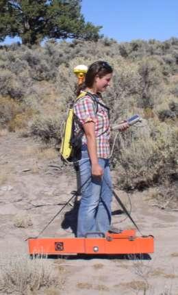
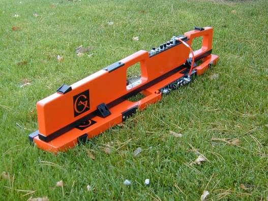
35 The new EM38-MK2 Ground Conductivity Meter effectively combines the performance features of all previous EM38 models in a single instrument: The EM38-MK2 provides measurement of both the quadphase (conductivity) and in-phase (magnetic susceptibility) components, within two distinct depth ranges, to a maximum effective depth of 1.5 m, all simultaneously.


36 In addition, new standard features and options each provide additional benefits: integrated Bluetooth functionality provides the option of wireless data transmission; a power input connector allows for the use of external power sources; a rechargeable external battery pack extends the duration of instrument operation; and a portable calibration stand provides the convenience of an automated calibration.


37 Geonics Standard Logging and Processing Software (DAT38MK2) XF101 DGPS Receiver for the Archer Field PC
38 A Look at some Third Party Data logging and mapping Software

39 Ag Leader & SMS Mobile


40 Farm Works Mobile Software


41 StarPal & HGIS PRO Software with Sensor Track


42 Use your iphone & ipad with WiSnap software App to collect data by Wifi-RS232 Serial module

43 SST Management Software Direct Geonics Data Import


44 Mobile EM38 Sleds & Trailers


45 Mobile EM38 Sleds & Trailers


46 Mobile EM38 Sleds & Trailers

47 Salinity Lab EMI rig Sled w/ Dual-dipole EM-38
48 EM Applications Groundwater Exploration & Contamination Precision Agriculture/Soil Salinity Environmental hazards (ie drums, waste containers, UST s, and UXO s) Pipelines, Utilities & Landfill Boundaries Buried trenches & pits Historical structures and artifacts Turfgrass

49 THE APPARENT CONDUCTIVITY OF SOILS WILL INCREASE WITH INCREASING: Water content, Clay content, Soluble salt content.
 and assess differences in magnetic")
50 EM Applications The quadrature component is used to measure the apparent conductivity (ECa) of earthen materials. The in-phase component can be used to detect objects of high conductivity (metals) and assess differences in magnetic susceptibility Pipe
51 Salinity Mapping & Management Zones

52 Management of Saline Soils
 EM31 on outrigger.")
53 Salinity Mapping & Management Zones EM38 in sled 50cm depth of investigation (Anning-Landline Geophysics) EM31 on outrigger. 4m depth of investigation.
54 Salinity Mapping Irrigated Pasture Deep Shallow Dryland Pasture

55 Salinity Mapping in Australia 200m

56 Salinity Mapping in Australia EM31-MK2 data to depth of 6m

57 Salinity Mapping in Australia EM38 data to depth of 1.5 m Chemical attributes with profile depth at location DeB01


58 Mapping soil and soil map unit inclusions Renshaw Fine-loamy over sandy or sandyskeletal, mixed, superactive, frigid Calcic Hapludolls Svea Fine-loamy, mixed, superactive, frigid Pachic Hapludolls (Doolittle-USDA)


59 Identifying soilhydrologic-landscape units


60 Spatiotemporal variations in EC a associated with changes in soil moisture Spring 2006 Fall 2005


 4306.94 Conductivity (ms/m) 4306.92-7731.64-7731.64-7731.63 (Vertical dipole) (Vertical dipole) HOLE 5 4306.92-7731.54-7731.")
61 EM38 Turf Grass Applications EM38 Soil Conductivity Survey HOLE FAIRWAY GREEN FAIRWAY GREEN Oak Hill Country Club Golf Course Conductivity (ms/m) Conductivity (ms/m) (Vertical dipole) (Vertical dipole) HOLE
 35 800 Very")

62 Hole 18 Conductivity (ms/m) Elevation (feet) Very conductive and wet due to drainage of water toward Tee Box


63 Conductivity maps of Drainage Patterns for Turf in Stadiums CRICKET STADIUM SOCCER STADIUM

64 Relating Soil Water Content, Conductivity and Crop Yield Conductivity Yield Purple Yellow Green Red Barley Field

65 Relating Soil Water Content, Conductivity and Crop Yield Conductivity Soil Water Content
66 In Conclusion..EM Conductivity Helps Any time of year No ground contact Any kind of weather Light weight, Low power Multiple Field correlations Low maintenance No moving parts Integration with existing Precision Software


67
Old & New? INTRODUCTION. The Best Proximal Geophysical Detector Ever!
 Measuring Soil Conductivity with Geonics Limited Electromagnetic Geophysical Instrumentation INTRODUCTION This presentation will briefly discuss the principles of operation and the practical applications
Electromagnetic Induction
 Electromagnetic Induction Recap the motivation for using geophysics We have problems to solve Slide 1 Finding resources Hydrocarbons Minerals Ground Water Geothermal Energy SEG Distinguished Lecture slide
Geology 228/378 Environmental Geophysics Lecture 10. Electromagnetic Methods (EM) I And frequency EM (FEM)
 I And frequency EM (FEM)") Geology 228/378 Environmental Geophysics Lecture 10 Electromagnetic Methods (EM) I And frequency EM (FEM) Lecture Outline Introduction Principles Systems and Methods Case Histories Introduction Many EM
Geology 228/378 Environmental Geophysics Lecture 10 Electromagnetic Methods (EM) I And frequency EM (FEM) Lecture Outline Introduction Principles Systems and Methods Case Histories Introduction Many EM
Here the goal is to find the location of the ore body, and then evaluate its size and depth.
 Geophysics 223 March 2009 D3 : Ground EM surveys over 2-D resistivity models D3.1 Tilt angle measurements In D2 we discussed approaches for mapping terrain conductivity. This is appropriate for many hydrogeology
Technical Note TN-30 WHY DOESN'T GEONICS LIMITED BUILD A MULTI-FREQUENCY EM31 OR EM38? J.D. McNeill
 Tel: (905) 670-9580 Fax: (905) 670-9204 GEONICS LIMITED E-mail:geonics@geonics.com 1745 Meyerside Dr. Unit 8 Mississauaga, Ontario Canada L5T 1C6 URL:http://www.geonics.com Technical Note TN-30 WHY DOESN'T
Geophysical Survey Rock Hill Bleachery TBA Site Rock Hill, South Carolina EP-W EPA, START 3, Region 4 TABLE OF CONTENTS Section Page Signature
 Geophysical Survey Rock Hill Bleachery TBA Site Rock Hill, South Carolina EP-W-05-054 EPA, START 3, Region 4 Prepared for: Tetra Tech EM, Inc. October 12, 2012 Geophysical Survey Rock Hill Bleachery TBA
3. Electromagnetic methods 3.1 Introduction
 3. Electromagnetic methods 3.1 Introduction The electromagnetic techniques have the broadest range of different instrumental systems. They can be classified as either time domain (TEM) of frequency domain
Geology 228 Applied Geophysics Lecture 10. Electromagnetic Methods (EM) (Reynolds, Ch. 10, 11)
 (Reynolds, Ch. 10, 11)") Geology 228 Applied Geophysics Lecture 10 Electromagnetic Methods (EM) (Reynolds, Ch. 10, 11) Lecture Outline Introduction Principles Systems and Methods (FDEM & TDEM) Case Histories APPLICATIONS 1. Mineral
Geology 228 Applied Geophysics Lecture 10 Electromagnetic Methods (EM) (Reynolds, Ch. 10, 11) Lecture Outline Introduction Principles Systems and Methods (FDEM & TDEM) Case Histories APPLICATIONS 1. Mineral
7. Consider the following common offset gather collected with GPR.
 Questions: GPR 1. Which of the following statements is incorrect when considering skin depth in GPR a. Skin depth is the distance at which the signal amplitude has decreased by a factor of 1/e b. Skin
GEONICS LIMITED LEADERS IN ELECTROMAGNETICS GEOPHYSICAL INSTRUMENTATION FOR EXPLORATION & THE ENVIRONMENT
 GEONICS LIMITED LEADERS IN ELECTROMAGNETICS GEOPHYSICAL INSTRUMENTATION FOR EXPLORATION & THE ENVIRONMENT GEONICS LIMITED 1745 Meyerside Drive, Unit 8 Mississauga, Ontario Canada L5T 1C6 Telephone: +1
Detection of Pipelines using Sub-Audio Magnetics (SAM)
") Gap Geophysics Australia Pty Ltd. Detection of Pipelines using Sub-Audio Magnetics is a patented technique developed by Gap Geophysics. The technique uses a fast sampling magnetometer to monitor magnetic
Gap Geophysics Australia Pty Ltd. Detection of Pipelines using Sub-Audio Magnetics is a patented technique developed by Gap Geophysics. The technique uses a fast sampling magnetometer to monitor magnetic
HELICOPTER-BORNE GEOPHYSICAL SURVEY SYSTEMS
 HELICOPTER-BORNE GEOPHYSICAL SURVEY SYSTEMS APPLICATIONS: base & precious metals exploration diamondiferous kimberlite exploration geological mapping mapping of fault zones for engineering and mining applications
STANDARD OPERATING PROCEDURES SOP:: 2057 PAGE: 1 of 6 REV: 0.0 DATE: 07/11/03
 PAGE: 1 of 6 1.0 SCOPE AND APPLICATION 2.0 METHOD SUMMARY CONTENTS 3.0 SAMPLE PRESERVATION, CONTAINERS, HANDLING, AND STORAGE 4.0 INTERFERENCES AND POTENTIAL PROBLEMS 5.0 EQUIPMENT/APPARATUS 6.0 REAGENTS
Electrical Resistivity Imaging
 Approved for Public Release; Distribution Unlimited Electrical Resistivity Imaging David Hull US Army Research Lab hull@arl.army.mil 17 Jun 2009 ARL Workshop on Personnel, Vehicle, and Tunnel Detection
Report. Mearns Consulting LLC. Former Gas Station 237 E. Las Tunas Drive San Gabriel, California Project # E
 Mearns Consulting LLC Report Former Gas Station 237 E. Las Tunas Drive San Gabriel, California Project #1705261E Charles Carter California Professional Geophysicist 20434 Corisco Street Chatsworth, CA
Ground Penetrating Radar
 Ground Penetrating Radar Begin a new section: Electromagnetics First EM survey: GPR (Ground Penetrating Radar) Physical Property: Dielectric constant Electrical Permittivity EOSC 350 06 Slide Di-electric
GEONICS LIMITED LEADERS IN ELECTROMAGNETICS GEOPHYSICAL INSTRUMENTATION FOR EXPLORATION & THE ENVIRONMENT
 GEONICS LIMITED LEADERS IN ELECTROMAGNETICS GEOPHYSICAL INSTRUMENTATION FOR EXPLORATION & THE ENVIRONMENT GEONICS LIMITED 1745 Meyerside Drive, Unit 8 Mississauga, Ontario Canada L5T 1C6 Telephone: +1
WHAT ARE WE MEASURING?
 WHAT ARE WE MEASURING? ASEG Workshop on Airborne Electromagnetics P th Perth November 7th 2012 P. Mutton, Consulting Geophysicist Southern Geoscience Consultants www.sgc.com.au WHAT ARE WE MEASURING? OUTLINE
Technical Note TN-31 APPLICATION OF DIPOLE-DIPOLE ELECTROMAGNETIC SYSTEMS FOR GEOLOGICAL DEPTH SOUNDING. Introduction
 Technical Note TN-31 APPLICATION OF DIPOLE-DIPOLE ELECTROMAGNETIC SYSTEMS FOR GEOLOGICAL DEPTH SOUNDING Introduction In Geonics Limited Technical Note TN-30 Why Doesn t Geonics Limited Build a Multi- Frequency
GCM mapping Vildbjerg - HydroGeophysics Group - Aarhus University
 GCM mapping Vildbjerg - HydroGeophysics Group - Aarhus University GCM mapping Vildbjerg Report number 06-06-2017, June 2017 Indholdsfortegnelse 1. Project information... 2 2. DUALEM-421s... 3 2.1 Setup
Automated anomaly picking from broadband electromagnetic data in an unexploded ordnance (UXO) survey
 survey") GEOPHYSICS, VOL. 68, NO. 6 (NOVEMBER-DECEMBER 2003); P. 1870 1876, 10 FIGS., 1 TABLE. 10.1190/1.1635039 Automated anomaly picking from broadband electromagnetic data in an unexploded ordnance (UXO) survey
GEOPHYSICS, VOL. 68, NO. 6 (NOVEMBER-DECEMBER 2003); P. 1870 1876, 10 FIGS., 1 TABLE. 10.1190/1.1635039 Automated anomaly picking from broadband electromagnetic data in an unexploded ordnance (UXO) survey
Sferic signals for lightning sourced electromagnetic surveys
 Sferic signals for lightning sourced electromagnetic surveys Lachlan Hennessy* RMIT University hennessylachlan@gmail.com James Macnae RMIT University *presenting author SUMMARY Lightning strikes generate
The use of high frequency transducers, MHz, allowing the resolution to target a few cm thick in the first half meter suspect.
 METHODOLOGY GPR (GROUND PROBING RADAR). In recent years the methodology GPR (Ground Probing Radar) has been applied with increasing success under the NDT thanks to the high speed and resolving power. As
Aquaflex Universal Soil Moisture Sensor (Model SI.162-mA) -User Manual- ma Version -
 -User Manual- ma Version -") Aquaflex Universal Soil Moisture Sensor (Model SI.162-mA) -User Manual- ma Version - The AQUAFLEX Universal Sensor (part # SI.162) uses the unique AQUAFLEX measurement technique using a 3m (10 ) long flexible
Aquaflex Universal Soil Moisture Sensor (Model SI.162-mA) -User Manual- ma Version - The AQUAFLEX Universal Sensor (part # SI.162) uses the unique AQUAFLEX measurement technique using a 3m (10 ) long flexible
Advanced Ground Investigation Techniques to Help Limit Risk or Examine Failure. Advanced Subsurface Investigations
 Advanced Ground Investigation Techniques to Help Limit Risk or Examine Failure Overview Introduction What is geophysics? Why use it? Common Methods Seismic Ground Radar Electrical Case Studies Conclusion
Taking Soil to the Cloud: Advanced Wireless Underground Sensor Networks for Real-time Precision Agriculture
 Taking Soil to the Cloud: Advanced Wireless Underground Sensor Networks for Real-time Precision Agriculture Abdul Salam Graduate Research Assistant Mehmet C. Vuran Susan J. Rosowski Associate Professor
Optimized shield design for reduction of EMF from wireless power transfer systems
 This article has been accepted and published on J-STAGE in advance of copyediting. Content is final as presented. IEICE Electronics Express, Vol.*, No.*, 1 9 Optimized shield design for reduction of EMF
Advanced Utility Locating Technologies (R01B)
") Advanced Utility Locating Technologies (R01B) Jacob Sheehan Senior Geophysicist Olson Engineering Phil Sirles Principal Geophysicist Olson Engineering Introduction: Utility Bundle Overview SHRP2 Strategic
Advanced Utility Locating Technologies (R01B) Jacob Sheehan Senior Geophysicist Olson Engineering Phil Sirles Principal Geophysicist Olson Engineering Introduction: Utility Bundle Overview SHRP2 Strategic
Improving electromagnetic induction detector technology in humanitarian demining
 57 APPENDIX 4 Improving electromagnetic induction detector technology in humanitarian demining R.C. Bailey, University of Toronto, Departments of Geology and Physics, Toronto, Canada G.F. West, University
ARCHAEOLOGICAL GEOPHYSICS: SENSOR SELECTION AND SITE SUITABILITY
 ARCHAEOLOGICAL GEOPHYSICS: SENSOR SELECTION AND SITE SUITABILITY A SPARC Webinar presented on October 17, 2014 Eileen G. Ernenwein, PhD ETSU: http://faculty.etsu.edu/ernenwei/ CAST: http://goo.gl/wyzlp
SIMULATION OF GPR SCENARIOS USING FDTD
 SIMULATION OF GPR SCENARIOS USING FDTD 1 GAMIL ALSHARAHI, 2 ABDELLAH DRIOUACH, 3 AHMED FAIZE 1,2 Department of physic, Abdelmalek Essaâdi University, Faculty of sciences, Morocco 3 Department of physic,
Lect2: EM Radio Waves and Antenna Operation
 Lect2: EM Radio Waves and Antenna Operation Dr. Yazid Khattabi Communication Systems Course EE Department University of Jordan 2018 Dr. Yazid Khattabi. The University of Jordan. 1 EM Radio Waves In wireless
Increasing the Probability of Detection and Evaluation of Buried Metallic Objects by Data Fusion GPR- Low Frequency Electromagnetic Sensor Array
 4th European-American Workshop on Reliability of NDE - Poster 4 Increasing the Probability of Detection and Evaluation of Buried Metallic Objects by Data Fusion GPR- Low Frequency Electromagnetic Sensor
Development and Field Testing of a Seismic System for Locating Trapped Miners - Progress Report. Yi Luo, Keith A. Heasley and Syd S.
 Development and Field Testing of a Seismic System for Locating Trapped Miners - Progress Report Yi Luo, Keith A. Heasley and Syd S. Peng Department of Mining Engineering West Virginia University Acknowledgements
In an unmagnetized piece of iron, the atoms are arranged in domains. In each domain the atoms are aligned, but the domains themselves are random.
 4/7 Properties of the Magnetic Force 1. Perpendicular to the field and velocity. 2. If the velocity and field are parallel, the force is zero. 3. Roughly (field and vel perp), the force is the product
Electromagnetic induction instruments have been used extensively
 Comparing Bulk Soil Electrical Conductivity Determination Using the DUALEM-1S and EM38-DD Electromagnetic Induction Instruments H. Abdu* Dep. of Biological and Irrigation Engineering Utah State Univ. Logan,
Archaeo-Geophysical Associates, LLC
 Geophysical Survey at the Parker Cemetery Rockwall, Texas. AGA Report 2010-6 Report Submitted To: Texas Cemetery Restoration 10122 Cherry Tree Dr. Dallas, Texas 75243 May 14, 2010 Chester P. Walker, Ph.D.
KT-20 MAGNETIC SUSCEPTIBILITY AND CONDUCTIVITY METER
 KT-20 MAGNETIC SUSCEPTIBILITY AND CONDUCTIVITY METER The KT-20 is a handheld instrument capable of measuring the magnetic susceptibility, conductivity or density of a sample. Its modular design provides
Chapter 25. Electromagnetic Waves
 Chapter 25 Electromagnetic Waves EXAM # 3 Nov. 20-21 Chapter 23 Chapter 25 Powerpoint Nov. 4 Problems from previous exams Physics in Perspective (pg. 836 837) Chapter 25 Electromagnetic Waves Units of
Aquaflex Universal Soil Moisture Sensor (Model SI.162-Pulse) -User Manual- Pulse Version -
 -User Manual- Pulse Version -") Aquaflex Universal Soil Moisture Sensor (Model SI.162-Pulse) -User Manual- Pulse Version - The AQUAFLEX Universal Sensor (part # SI.162) uses the unique AQUAFLEX measurement technique using a 3m (10 )
Aquaflex Universal Soil Moisture Sensor (Model SI.162-Pulse) -User Manual- Pulse Version - The AQUAFLEX Universal Sensor (part # SI.162) uses the unique AQUAFLEX measurement technique using a 3m (10 )
Stratagem EH4 Geometrics, Inc.
 Stratagem EH4 Geometrics, Inc. Stratagem EH4 Hybrid-Source Magnetotellurics Frequency range of 10 Hz to 90k Hz Approx. depth of investigation from 5m to 1km Portable with rapid setup and teardown Full
Decagon 10HS Moisture
 Measures the constant of the soil in order to find its content () The 10HS is used to measure moisture content of soils and other material for scientific research and agricultural applications. The 10HS
COMAPARISON OF SURVEY RESULTS FROM EM-61 AND BEEP MAT FOR UXO IN BASALTIC TERRAIN. Abstract
 COMAPARISON OF SURVEY RESULTS FROM EM-61 AND BEEP MAT FOR UXO IN BASALTIC TERRAIN Les P. Beard, Battelle-Oak Ridge, Oak Ridge, TN Jacob Sheehan, Battelle-Oak Ridge William E. Doll, Battelle-Oak Ridge Pierre
Analysis of Crack Detection in Metallic and Non-metallic Surfaces Using FDTD Method
 ECNDT 26 - We.4.3.2 Analysis of Crack Detection in Metallic and Non-metallic Surfaces Using FDTD Method Faezeh Sh.A.GHASEMI 1,2, M. S. ABRISHAMIAN 1, A. MOVAFEGHI 2 1 K. N. Toosi University of Technology,
Electronic Pipeline Technology
 Pipe and Cable Locator Pearson Holiday Detector Model EPT- 1000 Electronic Pipeline Technology Electronic Pipeline Technology 26 Palomino Drive, Richmond Hill, Ontario, Canada, L4C 0P8 Tel: (905) 918-0025
GPR SURVEY METHOD. Ground probing radar
 The ground penetrating radar (GPR - Ground Probing Radar) is a geophysical method used to investigate the near surface underground. Thanks to its high degree of resolution, the GPR is the most effective
Statement of Qualifications
 Revised January 29, 2011 ClearView Geophysics Inc. 12 Twisted Oak Street Brampton, ON L6R 1T1 Canada Phone: (905) 458-1883 Fax: (905) 792-1884 general@geophysics.ca www.geophysics.ca 1 1. Introduction
SITRANS F flowmeters. SITRANS F System information MAGFLO electromagnetic flowmeters 4/9
 Overview MAGFLO family MAGFLO electromagnetic are designed for measuring the flow of electrically conductive mediums. The patented MAGFLO Verificator guarantees accurate measurement and simple verification.
FINAL GEOPHYSICAL SURVEY REPORT CATLIN CEMETERY AND HISTORIC TRAILS PEABODY, KANSAS
 FINAL GEOPHYSICAL SURVEY REPORT CATLIN CEMETERY AND HISTORIC TRAILS PEABODY, KANSAS MARCH 2010 Prepared by: FPM Geophysical & UXO Services 5559 NW Barry Rd. #251 Kansas City, Missouri 64154 March 29, 2010
Active induction balance method for metal detector sensing head utilizing transmitterbucking and dual current source
 University of Zagreb Faculty of Electrical Engineering and Computing Department of Electronic Systems and Information Processing Active induction balance method for metal detector sensing head utilizing
TABLETOP MODELS FOR ELECTRICAL AND ELECTROMAGNETIC GEOPHYSICS
 TABLETOP MODELS FOR ELECTRICAL AND ELECTROMAGNETIC GEOPHYSICS Charles T. Young Department of Geological Engineering and Sciences, Michigan Technological University, Houghton, MI 49931, (906) 487-2072,
3 Dynatel M Series Locating and Marking System DOCUMENT NEW- TO- THE- WORLD TECHNOLOGY OBSOLETE DAMAGE PREVENTION PIN- POINT ACCURACY SAFETY
 3 Dynatel M Series Locating and Marking System NEW- TO- THE- WORLD TECHNOLOGY PIN- POINT ACCURACY SAFETY DAMAGE PREVENTION Introducing the 3M Dynatel M-iD Series Locating and Marking System. NEW TECHNOLOGY
GCM mapping Gedved - HydroGeophysics Group - Aarhus University
 GCM mapping Gedved - HydroGeophysics Group - Aarhus University GCM mapping Gedved Report number 23-06-2017, June 2017 1. INDHOLDSFORTEGNELSE 1. Indholdsfortegnelse... 1 2. Project information... 2 3. DUALEM-421s...
CHAPTER 5 Test B Lsn 5-6 to 5-8 TEST REVIEW
 IB PHYSICS Name: Period: Date: DEVIL PHYSICS BADDEST CLASS ON CAMPUS CHAPTER 5 Test B Lsn 5-6 to 5-8 TEST REVIEW 1. This question is about electric circuits. (a) (b) Define (i) (ii) electromotive force
A COMPARISON OF ELECTRODE ARRAYS IN IP SURVEYING
 A COMPARISON OF ELECTRODE ARRAYS IN IP SURVEYING John S. Sumner Professor of Geophysics Laboratory of Geophysics and College of Mines University of Arizona Tucson, Arizona This paper is to be presented
WaterScout SM100 Soil Moisture Sensor Catalog # 6460
 WaterScout SM100 Soil Moisture Sensor Catalog # 6460 Spectrum Technologies, Inc. 2 CONTENTS General Overview 3 Specifications 4 Sensor Placement 5 Hardware/Software Compatibility 6 Checking the Sensor
Metal Detector Description
 Metal Detector Description A typical metal detector used for detecting buried coins, gold, or landmines consists of a circular horizontal coil assembly held just above the ground. A pulsed or alternating
Experiment on Artificial Frozen Soil Boundary GPR Detection During Cross-passage Construction in Tunnels
 354 Progress In Electromagnetics Research Symposium 2005, Hangzhou, China, August 22-26 Experiment on Artificial Frozen Soil Boundary GPR Detection During Cross-passage Construction in Tunnels Yong-Hui
High-]FrequencyElectric Field Measurement Using a Toroidal Antenna
![High-]FrequencyElectric Field Measurement Using a Toroidal Antenna](/thumbs/87/96632311.jpg "High-]FrequencyElectric Field Measurement Using a Toroidal Antenna") LBNL-39894 UC-2040 ERNEST ORLANDO LAWRENCE B ERKELEY NAT o NAL LABo RATO RY High-]FrequencyElectric Field Measurement Using a Toroidal Antenna Ki Ha Lee Earth Sciences Division January 1997!.*. * c DSCLAMER
LBNL-39894 UC-2040 ERNEST ORLANDO LAWRENCE B ERKELEY NAT o NAL LABo RATO RY High-]FrequencyElectric Field Measurement Using a Toroidal Antenna Ki Ha Lee Earth Sciences Division January 1997!.*. * c DSCLAMER
Subsurface Resistivity Measurements Using Square Waveforms
 IEEE Instrumentation and Measurement Technology Conference Ottawa, Canada, May 19-21,1997 Subsurface Resistivity Measurements Using Square Waveforms Manel Gasulla, Josep Jordana, Ramon Pallas-Areny and
Dartmouth College LF-HF Receiver May 10, 1996
 AGO Field Manual Dartmouth College LF-HF Receiver May 10, 1996 1 Introduction Many studies of radiowave propagation have been performed in the LF/MF/HF radio bands, but relatively few systematic surveys
Ground Penetrating Radar (day 1) EOSC Slide 1
 EOSC Slide 1") Ground Penetrating Radar (day 1) Slide 1 Introduction to GPR Today s Topics Setup: Motivational Problems Physical Properties - Dielectric Permittivity and Radiowaves - Microwave Example Basic Principles:
Ground Penetrating Radar (day 1) Slide 1 Introduction to GPR Today s Topics Setup: Motivational Problems Physical Properties - Dielectric Permittivity and Radiowaves - Microwave Example Basic Principles:
SCATTERING POLARIMETRY PART 1. Dr. A. Bhattacharya (Slide courtesy Prof. E. Pottier and Prof. L. Ferro-Famil)
") SCATTERING POLARIMETRY PART 1 Dr. A. Bhattacharya (Slide courtesy Prof. E. Pottier and Prof. L. Ferro-Famil) 2 That s how it looks! Wave Polarisation An electromagnetic (EM) plane wave has time-varying
SCATTERING POLARIMETRY PART 1 Dr. A. Bhattacharya (Slide courtesy Prof. E. Pottier and Prof. L. Ferro-Famil) 2 That s how it looks! Wave Polarisation An electromagnetic (EM) plane wave has time-varying
SURVEYING THE UNDERGROUND
 SURVEYING THE UNDERGROUND An Introduction to ASCE 38-02 and the Practice of Subsurface Utility Engineering ACECMD March 28, 2018 Presented by: Art Worthman A. Morton Thomas & Associates, Inc. John Berrettini
Chapter 21. Alternating Current Circuits and Electromagnetic Waves
 Chapter 21 Alternating Current Circuits and Electromagnetic Waves AC Circuit An AC circuit consists of a combination of circuit elements and an AC generator or source The output of an AC generator is sinusoidal
SITRANS F flowmeters. SITRANS F M System information MAGFLO electromagnetic flowmeters. 4/18 Siemens FI
 Function All are based on Faraday s law of induction: U M = B v d k U M = Measured voltage induced in the medium perpendicular to the magnetic field and the flow direction. The voltage is tapped at two
On-time EM measurements: UTEM system developments
 On-time EM measurements: UTEM system developments Sixth Decennial International Conference on Mineral Exploration Workshop 6: Advances in Geophysical Technology Workshop - October 22, 2017 Yves Lamontagne,
ELECTROMAGNETIC FIELD APPLICATION TO UNDERGROUND POWER CABLE DETECTION
 ELECTROMAGNETIC FIELD APPLICATION TO UNDERGROUND POWER CABLE DETECTION P Wang *, K Goddard, P Lewin and S Swingler University of Southampton, Southampton, SO7 BJ, UK *Email: pw@ecs.soton.ac.uk Abstract:
Inductive Conductivity Measurement of Seawater
 Inductive Conductivity Measurement of Seawater Roger W. Pryor, Ph.D. Pryor Knowledge Systems *Corresponding author: 498 Malibu Drive, Bloomfield Hills, MI, 48302-223, rwpryor@pksez.com Abstract: Approximately
INVERSION OF EM DATA TO RECOVER 1-D CONDUCTIVITY AND A GEOMETRIC SURVEY PARAMETER. Sean Eugene Walker
 INVERSION OF EM DATA TO RECOVER 1-D CONDUCTIVITY AND A GEOMETRIC SURVEY PARAMETER By Sean Eugene Walker B. Sc. (Honours), Geology & Physics, McMaster University, 1996 a thesis submitted in partial fulfillment
On measuring electromagnetic surface impedance - Discussions with Professor James R. Wait
 On measuring electromagnetic surface impedance - Discussions with Professor James R. Wait Author Thiel, David Published 2000 Journal Title IEEE Transactions on Antennas and Propagation DOI https://doi.org/10.1109/8.899667
Industrial and Commercial Power Systems Topic 7 EARTHING
 The University of New South Wales School of Electrical Engineering and Telecommunications Industrial and Commercial Power Systems Topic 7 EARTHING 1 INTRODUCTION Advantages of earthing (grounding): Limitation
Appendix I Geophysical Survey
 DRAFT IRM PRE- DESIGN INVESTIGATION DATA SUMMARY REPORT NATIONAL GRID FULTON MUNICIPAL WORKS FORMER MGP SITE APRIL 2013 Appendix I Geophysical Survey GEOPHYSICAL SURVEY FULTON MUNICIPAL WORKS FORMER MGP
A Method of Mapping Resistive or Conductive offshore Targets also an Apparatus for Applying the Method
 A Method of Mapping Resistive or Conductive offshore Targets also an Apparatus for Applying the Method BACKGROUND OF THE INVENTION 1. Field of the Invention The present invention is related to a method
An explanation for the magic low frequency magnetic field shielding effectiveness of thin conductive foil with a relative permeability of 1
 An explanation for the magic low frequency magnetic field shielding effectiveness of thin conductive foil with a relative permeability of 1 D.A. Weston K McDougall (magicse.r&d.doc) 31-7-2006 The data
Alternating Current. Slide 1 / 69. Slide 2 / 69. Slide 3 / 69. Topics to be covered. Sources of Alternating EMF. Sources of alternating EMF
 Slide 1 / 69 lternating urrent Sources of alternating EMF Transformers ircuits and Impedance Topics to be covered Slide 2 / 69 LR Series ircuits Resonance in ircuit Oscillations Sources of lternating EMF
Alternating Current. Slide 2 / 69. Slide 1 / 69. Slide 3 / 69. Slide 4 / 69. Slide 6 / 69. Slide 5 / 69. Topics to be covered
 Slide 1 / 69 lternating urrent Sources of alternating EMF ircuits and Impedance Slide 2 / 69 Topics to be covered LR Series ircuits Resonance in ircuit Oscillations Slide 3 / 69 Sources of lternating EMF
ELECTROMAGNETIC INDUCTION AND ALTERNATING CURRENT (Assignment)
") ELECTROMAGNETIC INDUCTION AND ALTERNATING CURRENT (Assignment) 1. In an A.C. circuit A ; the current leads the voltage by 30 0 and in circuit B, the current lags behind the voltage by 30 0. What is the
ELECTROMAGNETIC INDUCTION AND ALTERNATING CURRENT (Assignment) 1. In an A.C. circuit A ; the current leads the voltage by 30 0 and in circuit B, the current lags behind the voltage by 30 0. What is the
Applied Geophysics Nov 2 and 4
 Applied Geophysics Nov 2 and 4 Effects of conductivity Surveying geometries Noise in GPR data Summary notes with essential equations Some Case histories EOSC 350 06 Slide 1 GPR Ground Penetrating Radar
Lab E2: B-field of a Solenoid. In the case that the B-field is uniform and perpendicular to the area, (1) reduces to
 reduces to") E2.1 Lab E2: B-field of a Solenoid In this lab, we will explore the magnetic field created by a solenoid. First, we must review some basic electromagnetic theory. The magnetic flux over some area A is
E2.1 Lab E2: B-field of a Solenoid In this lab, we will explore the magnetic field created by a solenoid. First, we must review some basic electromagnetic theory. The magnetic flux over some area A is
Faraday Laws of Electromagnetic Induction CLIL LESSON
 Faraday Laws of Electromagnetic Induction CLIL LESSON Experimental trials Michael Faraday-1931 This law shows the relationship between electric circuit and magnetic field A coil is connected to a galvanometer
AA&S Conference 2018 Eddy Current Array for Aircraft
 AA&S Conference 2018 Eddy Current Array for Aircraft Presented by Graham Maxwell Olympus Australia NDT Key Account Manager Material provided by Ghislain Morais Olympus NDT Canada Eddy Current Array ECA
Pitfalls in GPR Data Interpretation: Differentiating Stratigraphy and Buried Objects from Periodic Antenna and Target Effects
 GEOPHYSICAL RESEARCH LETTERS, VOL. 27, NO. 20, PAGES 3393-3396, OCTOBER 15, 2000 Pitfalls in GPR Data Interpretation: Differentiating Stratigraphy and Buried Objects from Periodic Antenna and Target Effects
Transfer Functions in EMC Shielding Design
 Transfer Functions in EMC Shielding Design Transfer Functions Definition Overview of Theory Shielding Effectiveness Definition & Test Anomalies George Kunkel CEO, Spira Manufacturing Corporation www.spira-emi.com
Aquaflex Soil Moisture Sensor (SI.60) -User Manual-
 -User Manual-") Aquaflex Soil Moisture Sensor (SI.60) -User Manual- These Aquaflex sensors can be connected to: An Aquaflex Datalogger (sensor part number SI.60-D) and both Soil Moisture and Temperature may be logged,
Aquaflex Soil Moisture Sensor (SI.60) -User Manual- These Aquaflex sensors can be connected to: An Aquaflex Datalogger (sensor part number SI.60-D) and both Soil Moisture and Temperature may be logged,
Chapter 25. Electromagnetic Induction
 Lecture 28 Chapter 25 Electromagnetic Induction Electromagnetic Induction Voltage is induced (produced) when the magnetic field changes near a stationary conducting loop or the conductor moves through
NDT-PRO Services expands service offering
 NDT-PRO Services expands service offering NDT-PRO Services announced the formal release of two advanced NDT methods, Phased Array (including TOFD) and Eddy Current. What are they and where are the used?
EDDY CURRENT TESTING
 NEW SOUTH WALES TECHNICAL AND FURTHER EDUCATION COMMISSION EDDY CURRENT TESTING NSW Module Number: Implementation Date: 6161C 01-Jan-1998 National Module Code: EA605 MANUFACTURING AND ENGINEERING MECHANICAL
An acousto-electromagnetic sensor for locating land mines
 An acousto-electromagnetic sensor for locating land mines Waymond R. Scott, Jr. a, Chistoph Schroeder a and James S. Martin b a School of Electrical and Computer Engineering b School of Mechanical Engineering
Application of Ground Penetrating Radar for River Ice Surveys
 CGU HS Committee on River Ice Processes and the Environment 14th Workshop on the Hydraulics of Ice Covered Rivers Quebec City, June 19-22, 2007 Application of Ground Penetrating Radar for River Ice Surveys
RF Energy Harvesting for Low Power Electronic Devices
 RF Energy Harvesting for Low Power Electronic Devices Student project Kaloyan A. Mihaylov Abstract Different methods for RF energy harvesting from radio transmitters with working frequency of up to 108
General features. On the main menu, two values are permanently displayed: The ground mineralisation index (phase measured constantly for information).
.") General features The different levels of soil mineralisation you encounter when prospecting can sometimes affect the performance of your detector. For example, this may be due to natural magnetic mineralisation
General features The different levels of soil mineralisation you encounter when prospecting can sometimes affect the performance of your detector. For example, this may be due to natural magnetic mineralisation
Locating good conductors by using the B-field integrated from partial db/dt waveforms of timedomain
 Locating good conductors by using the integrated from partial waveforms of timedomain EM systems Haoping Huang, Geo-EM, LLC Summary An approach for computing the from time-domain data measured by an induction
OPERATIVE GUIDE V.E.S. VERTICAL ELECTRIC SURVEY
 OPERATIVE GUIDE V.E.S. VERTICAL ELECTRIC SURVEY 1 Quadrupole geoelectric procedure (V.E.S.) Generals V.E.S. (Vertical Electric Survey) geoelectric prospection method consists in investigating a specific
ALIS. Project Identification Project name Acronym
 ALIS Project Identification Project name ALIS Acronym Advanced Landmine Imaging System Participation Level National (Japanese) Financed by JST(Japan Science and Technology Agency) Budget N/A Project Type
We are IntechOpen, the world s leading publisher of Open Access books Built by scientists, for scientists. International authors and editors
 We are IntechOpen, the world s leading publisher of Open Access books Built by scientists, for scientists 3,500 108,000 1.7 M Open access books available International authors and editors Downloads Our
DEEP FLAW DETECTION WITH GIANT MAGNETORESISTIVE (GMR) BASED SELF-NULLING PROBE
 BASED SELF-NULLING PROBE") DEEP FLAW DETECTION WITH GIANT MAGNETORESISTIVE (GMR) BASED SELF-NULLING PROBE Buzz Wincheski and Min Namkung NASA Langley Research Center Hampton, VA 23681 INTRODUCTION The use of giant magnetoresistive
DEEP FLAW DETECTION WITH GIANT MAGNETORESISTIVE (GMR) BASED SELF-NULLING PROBE Buzz Wincheski and Min Namkung NASA Langley Research Center Hampton, VA 23681 INTRODUCTION The use of giant magnetoresistive
GPR Part II: Effects of conductivity. Surveying geometries. Noise in GPR data. Summary notes with essential equations. Some Case histories
 GPR Part II: Effects of conductivity Surveying geometries Noise in GPR data Summary notes with essential equations Some Case histories EOSC 350 06 Slide 1 GPR Ground Penetrating Radar R = ε ε 2 2 + ε ε
Identification of UXO by regularized inversion for Surface Magnetic Charges Nicolas Lhomme, Leonard Pasion and Doug W. Oldenburg
 Identification of UXO by regularized inversion for Surface Magnetic Charges Nicolas Lhomme, Leonard Pasion and Doug W. Oldenburg The University of British Columbia, Vancouver, BC, Canada Sky Research Inc.,