Kongsberg Maritime Product overview
|
|
|
- Trevor Pierce
- 5 years ago
- Views:
Transcription

1 Kongsberg Maritime Product overview / 1 / 1-Nov-12
2 Frequency Range Coverage 125,250,500kHz m 12xD kHz m 5.5xD / deg 300 khz m 4-10xD / deg khz m 5.5xD / 140 deg 30 khz m 5.5xD / 140 deg 12 khz m 6xD / 150 deg khz m 3,6,12 degree khz m 5 degree 1 10 khz m 5 degree 2 12 khz Towed 55 degree kHz m S 114/410 khz Towed khz AUV >400m Number of system sold: >900 EM multibeams systems / >1250 EA singlebeam systems

 - Depth resolution 6mm(125), 3mm(250), 1.")
3 Geoswath+ Wide swath bathymetry system Applications from shallow to very shallow water surveys Key features: / 250 and 500 khz version available - Max range >200, 100 and 50 m - Dual transducer system - Max coverage 780 / 390 and 195m or >12x D (240dg) - Along track beam width 0.85 (125), 0.75(250), 0.5(500) - Depth resolution 6mm(125), 3mm(250), 1.5mm(500) - Pulse length 32 μs to 896 μs - Pingrate >30Hz - For ROV / AUV - Transducer depth rating 4000m


4 Geoswath+ Wide swath bathymetry system

5 Geoswath+ Wide swath bathymetry system
/200dg(D) - Dual swath with 800 soundings - Sector transmitting, 3 sectors - Modular design 0.")
6 True wide band and high resolution Multibeam echosounder Applications from very high resolution inspection to shallow water surveys Key features: khz operating frequency - Max range >500m - Single and dual RX - Max coverage >500m, 140dg(S)/200dg(D) - Dual swath with 800 soundings - Sector transmitting, 3 sectors - Modular design 0.5x1 and 1x1 (300kHz) - Pingrate >50Hz - Pulse length from <20ms to 600us using FM chirp and CW - Roll, pitch compensated - Roll, pitch, yaw stabilized - Transducer depth rating 6000m


7 True wide band and high resolution Multibeam echosounder

8 True wide band and high resolution Multibeam echosounder Victor Hensen installation: 0.5 * 1 degree Dual swath Concrete target 2*8 m One half is 50 cm higher A 1 m tower at the corner, 30*30 cm at top. 19 m depth 1 30*30 cm 400 khz, 50 us, one single line, gridded. OSAE, Victor Hensen 8 2


9 True wide band and high resolution Multibeam echosounder ROV test at 2000m depth GOM Courtesy of Chevron
10 High resolution wide band Medium water Multibeam echosounder Applications from high resolution to medium water survey Key features: - Operating frequency 70 to 100 khz - Max range >2000m - Max coverage >2500m / 140dg - Modular design, from 0.5x1 to 2x2 degree beam width - Dual swath with 800 soundings - Sector transmitting, 3 sectors for increased performance - Pingrate >30Hz - Pulse length from 0.2ms to 120ms utilizing CW and FM - Dynamic focusing on both transmit and receive - Roll, pitch compensated Shoal of fish - Roll, pitch, yaw stabilization - Compliance with IHO Special order

11 High resolution wide band Medium water Multibeam echosounder Applications from high resolution to medium water survey Shoal of fish


12 High resolution wide band Medium water Multibeam echosounder Applications from high resolution to medium water survey Shoal of fish
13 Deep water Multibeam echosounder Applications from medium to deep water surveys, for the continental rise including the shallower ocean basins, down to 7000m. Key features: - Operating frequency 26 to 34 khz - Max range >7000m - Max coverage >8000m / or 140dg - Modular design, from 0.5x1 to 4x4 degree beam width - Dual swath with 864 soundings - Sector transmitting, 8 sectors - Pingrate >10Hz - Pulse length from 0.7ms to 30ms using FM chirp and CW - Dynamic focusing both on transmit and receive - Roll, pitch compensated - Roll, pitch, yaw stabilized - Compliant with IHO Order 1

14 Deep water Multibeam echosounder Applications from medium to deep water surveys, for the continental rise including the shallower ocean basins, down to 7000m.


15 Deep water Multibeam echosounder Applications from medium to deep water surveys, for the continental rise including the shallower ocean basins, down to 7000m. Bubbles from Subsea Chimney, detected Using Water column From Courtesy of NOAA, Okeanos Explorer
16 Deep water Multibeam echosounder Applications from medium to full ocean depth. Key features: - Operating frequency 10.5 to 13 khz - Max range >full ocean depth - Coverage >30-35km / 150dg - Modular design, from 0.5x1 to 2x4 degree beam width - Dual swath with 864 soundings - Sector transmitting, 8 sectors, for increased performance - Pingrate >5Hz - Pulse length from 2ms to 30ms, using FM chirp and CW - Dynamic focusing both on transmit and receive - Roll, pitch compensated - Roll, pitch, yaw stabilized - Compliant with IHO Order 1

17 Deep water Multibeam echosounder Applications from medium to full ocean depth.


18 Deep water Multibeam echosounder Applications from medium to full ocean depth. Courtesy of NAVO meter across 62/61º coverage Detailed mapping of the Gakkel Ridge, 4000m Courtesy of University of Stockholm


19 EA 400 / EA 600 hydrographic singlebeam echosounders Key features: - EA 400 operating frequency khz - EA 600 operating frequency khz - Up to 4 channels per system - 2 channels per GPT
KONGSBERG seafloor-mapping echosounders
 KONGSBERG seafloor-mapping echosounders Berit Horvei WORLD CLASS through people, technology and dedication AGENDA Historical overview EM series Multibeam echosounder and Subbottom profiler Topside software.
BRINGING CLARITY TO THE WORLD BELOW THE COMPLETE UNDERWATER MAPPING PRODUCT RANGE
 BRINGING CLARITY TO THE WORLD BELOW THE COMPLETE UNDERWATER MAPPING PRODUCT RANGE BRINGING CLARITY TO THE WORLD BELOW OUR MISSION We shall earn the respect and recognition for our dedication to provide
Experiences with Hydrographic Data Budgets Using a Low-logistics AUV Platform. Thomas Hiller Teledyne Marine Systems
 Experiences with Hydrographic Data Budgets Using a Low-logistics AUV Platform Thomas Hiller Teledyne Marine Systems 1 Teledyne Marine Systems Strategic Business Units 2 What is the Gavia? The Gavia is
Survey Sensors. 18/04/2018 Danny Wake Group Surveyor i-tech Services
 Survey Sensors 18/04/2018 Danny Wake Group Surveyor i-tech Services What do we need sensors for? For pure hydrographic surveying: Depth measurements Hazard identification Seabed composition Tides & currents
SYSTEM 5900 SIDE SCAN SONAR
 SYSTEM 5900 SIDE SCAN SONAR HIGH-RESOLUTION, DYNAMICALLY FOCUSED, MULTI-BEAM SIDE SCAN SONAR Klein Marine System s 5900 sonar is the flagship in our exclusive family of multi-beam technology-based side
Sonar advancements for coastal and maritime surveys
 ConférenceMéditerranéenneCôtièreetMaritime EDITION1,HAMMAMET,TUNISIE(2009) CoastalandMaritimeMediterraneanConference Disponibleenligne http://www.paralia.fr Availableonline Sonar advancements for coastal
EK60. SCIENTIFIC SOUNDER SCIENTIFIC ECHO SOUNDER
 EK60 SCIENTIFIC ECHO SOUNDER HIGH DYNAMIC RANGE RAW DATA RECORDING LOW SELF NOISE HIGH PING RATE MULTI FREQUENCY APPLICATION FOR SPECIES ID SEVERAL FREQUENCIES COVERING SAME SAMPLE VOLUME REMOTE CONTROL
global acoustic positioning system GAPS usbl acoustic with integrated INS positioning system Ixsea Oceano GAPS page 1
 global acoustic positioning system usbl acoustic positioning system with integrated INS positioning system page 1 THE MERGER OF INERTIAL AND UNDERWATER ACOUSTIC TECHNOLOGIES is a unique Global Acoustic
Sonars TECHNOLOGY FOR SUSTAINABLE FISHERIES
 Sonars TECHNOLOGY FOR SUSTAINABLE FISHERIES SIMRAD SU90 SONAR The SU90 Sonar is made with no compromises. The number of channels has been increased by 50% compared to the SX90 Sonar giving the sonar an
GeoSwath Plus Wide swath bathymetry and georeferenced side scan
 GeoSwath Plus Wide swath bathymetry and georeferenced side scan www.geoacoustics.com GeoSwath Plus Wide Swath Bathymetry and co-registered georeferenced side scan system We maximise marine performance
Teledyne Marine Acoustic Imagining
 RESON SeaBat high performance sonars for long range object detection and MCM applications Navigation, object avoidance & up close inspection with BlueView Greg Probst Sales Manager, Defense Teledyne Marine
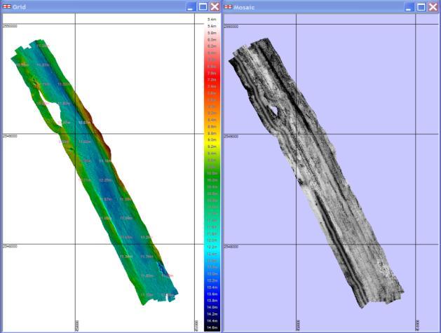
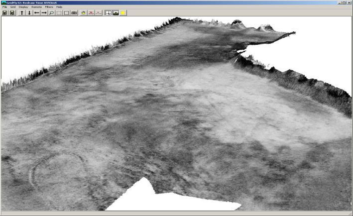
Seafloor Mapping Using Interferometric Sonars: Advances in Technology and Techniques
 Seafloor Mapping Using Interferometric Sonars: Advances in Technology and Techniques Tom Hiller, Advanced Products Manager, GeoAcoustics Ltd. WORLD CLASS through people, technology and dedication Brest,
Applications of iusbl Technology overview
 Applications of iusbl Technology overview Tom Bennetts Project Manager Summary 1. What is iusbl and its target applications 2. Advantages of iusbl and sample data 3. Technical hurdles and Calibration methods
Side-Scan Sonar Presentation STS
 Training Module Side-Scan Sonar Presentation STS SIDE-SCAN SONAR SAFETY Training Module Content: This module includes information on: Types of Side-Scan Benefits and Disadvantages System Configuration
Company Profile. Facilities
 Company Profile R2Sonic was founded in February 2006 by three veteran underwater acoustical engineers; Jens R. Steenstrup, Mark Chun and Kirk Hobart; with the mission to utilize their experience to bring
Positioning Small AUVs for Deeper Water Surveys Using Inverted USBL
 Positioning Small AUVs for Deeper Water Surveys Using Inverted USBL Presented at Hydro12, Rotterdam, November 2012 Dr. T.M. Hiller, thiller@teledyne.com Overview Introduction to Gavia AUV Gavia Acoustic
Lake Borgne, Louisiana Debris Mapping
 Lake Borgne, Louisiana Debris Mapping Abstract Gary R. Davis, Paul L. Donaldson, Walter Simmons, Rebecca Quintal Science Applications International Corporation 221 Third Street Newport, RI 02840 USA Under
EM 710. Multibeam echo sounder
 EM 710 Multibeam echo sounder EM 710 Multibeam echo sounder Product description This document presents a brief technical description of the EM 710 multibeam echo sounder. About this document Rev Date
Multibeam Echosounder Metadata and Quality Statistics
 Multibeam Echosounder Metadata and Quality Statistics Dave Mann, Survey Support Manager, Gardline Geosurvey Gardline MBES Systems Sea Explorer EM1002 RV Triton EM1002(S) Ocean Seeker EM1002(S) Ocean Endeavour
The limits of spatial resolution achievable using a 30kHz multibeam sonar: model predictions and field results.
 The limits of spatial resolution achievable using a 30kHz multibeam sonar: model predictions and field results. John E. Hughes Clarke (1), James V. Gardner (2), Mike Torresan (2), and Larry Mayer (1) (1)
Echosounders TECHNOLOGY FOR SUSTAINABLE FISHERIES
 Echosounders TECHNOLOGY FOR SUSTAINABLE FISHERIES ES80 ECHOSOUNDER SIMRAD has manufactured fishfinders for more than 70 years and has 25 years of experience using Split beam technology. The first Split
Handling Interferometric Data: Streamlining the Processing Flow
 Handling Interferometric Data: Streamlining the Processing Flow Paper 5 at Hydro8, 4 th November 2008 Tom Hiller, Advanced Products Manager, GeoAcoustics Ltd. WORLD CLASS through people, technology and
Pioneers of Wideband High Resolution Multibeam Systems
 Pioneers of Wideband High Resolution Multibeam Systems W W W. R 2 S O N I C. C O M Systems Overview The R2Sonic Sonic Series are the world s first true wideband high resolution Motion Heading SV GPS shallow
Ongoing Developments in Side Scan Sonar The pursuit of better Range, Resolution and Speed
 Ongoing Developments in Side Scan Sonar The pursuit of better Range, Resolution and Speed Nick Lawrence EdgeTech Advances in Seafloor-mapping Sonar Conference 30 th November 2009 Company Profile EdgeTech
Simrad SX90 Long range high definition sonar system
 Simrad SX90 Long range high definition sonar system 360 omnidirectional sonar 90 vertical tip mode 20 to 30 KHz operational frequency Narrow beams Selectable beam width Hyperbolic FM Large dynamic range
Tritech International Vehicle Sonar Developments
 Tritech International Vehicle Sonar Developments Mike Broadbent Business Development Manager Oceanology 2012 - UUVS Overview About Tritech Mechanical Scanning Sonar - Improving the performance High Speed
INTRODUCING AN OPERATIONAL MULTI-BEAM ARRAY SONAR
 INTRODUCING AN OPERATIONAL MULTI-BEAM ARRAY SONAR b y Morris F. G l e n n Oceanographer U.S. Naval Oceanographic Office PRECIS The Multi-Beam Array Sonar Survey System is a revolutionary new bathymetric
PRINCIPLE OF SEISMIC SURVEY
 PRINCIPLE OF SEISMIC SURVEY MARINE INSTITUTE Galway, Ireland 29th April 2016 Laurent MATTIO Contents 2 Principle of seismic survey Objective of seismic survey Acquisition chain Wave propagation Different
Pipeline Inspection and Environmental Monitoring Using AUVs
 Pipeline Inspection and Environmental Monitoring Using AUVs Bjørn Jalving, Bjørn Gjelstad, Kongsberg Maritime AUV Workshop, IRIS Biomiljø, 7 8 September 2011 WORLD CLASS through people, technology and
Mid-Frequency Reverberation Measurements with Full Companion Environmental Support
 DISTRIBUTION STATEMENT A. Approved for public release; distribution is unlimited. Mid-Frequency Reverberation Measurements with Full Companion Environmental Support Dajun (DJ) Tang Applied Physics Laboratory,
Motion Reference Units
 Motion Reference Units MRU Datasheet Rev. 1.3 IP-67 sealed 5% / 5 cm Heave accuracy 0.03 m/sec Velocity accuracy 0.05 deg Pitch and Roll accuracy 0.005 m/sec2 Acceleration accuracy 0.0002 deg/sec Angular
R/V Falkor Multibeam Echosounder System Review
 University of New Hampshire University of New Hampshire Scholars' Repository Center for Coastal and Ocean Mapping Center for Coastal and Ocean Mapping 4-2-2013 R/V Falkor Multibeam Echosounder System Review
UNDERWATER NOISE, MARINE SPECIES PROTECTION, AND IMPLICATIONS FOR MARINE SURVEYS. Presenter: Denise Toombs Company: ERM
 UNDERWATER NOISE, MARINE SPECIES PROTECTION, AND IMPLICATIONS FOR MARINE SURVEYS Presenter: Denise Toombs Company: ERM Presenter Profile Ms. Denise Toombs is a Partner at ERM with over 25 years of experience
Semi-buried seabed object detection: Sonar vs. Geophysical methods
 Semi-buried seabed object detection: Sonar vs. Geophysical methods Dino DRAGUN, Croatia, Lieselot NOPPE, Belgium, Pierre SERPE, Belgium, Emeline CARON, France, Astrid ROBERT, France Key words: Site Investigation,
Research Vessel Technical Enhancement Committee (RVTEC) November 2009 Meeting ISS - Integrated Survey Systems
 November 2009 Meeting ISS - Integrated Survey Systems") Research Vessel Technical Enhancement Committee (RVTEC) November 2009 Meeting ISS - Integrated Survey Systems John Kiernan, P.E. SAIC - Marine Science and Technology Division ISS-2000 Integrated Survey
Research Vessel Technical Enhancement Committee (RVTEC) November 2009 Meeting ISS - Integrated Survey Systems John Kiernan, P.E. SAIC - Marine Science and Technology Division ISS-2000 Integrated Survey
Object Detection with Phase-Measuring Bathymetric Sidescan Sonar Depth Data
 Object Detection with Phase-Measuring Bathymetric Sidescan Sonar Depth Data Kevin Jerram and Val Schmidt Center for Coastal and Ocean Mapping Durham, New Hampshire A shipwreck and bedforms are visible
Multi-Beam Echo Sounders do beam width, frequency, number of beams matter? James Williams Managing Director
 Multi-Beam Echo Sounders do beam width, frequency, number of beams matter? James Williams Managing Director 1 Swathe Services We offer Product Sales, Equipment Rental and Personnel Deployment Our latest
DP Operator Course Training Manual HPR
 - Hydroacoustic Position Reference System consists of transducer(s) onboard a vessel communicating with transponder(s) placed on the seabed. The transducers are lowered beneath the hull, and when a transponder
Automation at Depth: Ocean Infinity and seabed mapping using multiple AUVs
 Automation at Depth: Ocean Infinity and seabed mapping using multiple AUVs Ocean Infinity s seabed mapping campaign commenced in the summer of 2017. The Ocean Infinity team is made up of individuals from
SONOGRAPHIC PHYSICS, INSTRUMENTATION & DOPPLER REVIEW Part 3
 SONOGRAPHIC PHYSICS, INSTRUMENTATION & DOPPLER REVIEW 2012 Part 3 1 Doppler Imaging 2 DOPPLER TRANSDUCER SAME FREQUENCY During Doppler operation, the reflected sound has the same frequency as the transmitted
SONARMITE v4.0 MTX sweep version - PORTABLE BLUETOOTH ECHO SOUNDER
 SONARMITE v4.0 MTX sweep version - PORTABLE BLUETOOTH ECHO SOUNDER Introduction The SonarMite Echo Sounder was the result of nearly two years research and development to further extend the boundaries of
Gyrocompass and motion sensor. octans. navigation and positioning
 Gyrocompass and motion sensor octans navigation and positioning the best in fog technology The technological heart of is the Fibre-Optic Gyroscope (FOG), the only truly-solid-state answer to rotation sensing.
ASO 713/723 Hull-Mounted Active Sonar
 ASO 713/723 Hull-Mounted Active Sonar ASO Anti-Submarine Warfare... a sound decision ATLAS ELEKTRONIK Naval Underwater Theatre ASO The ATLAS ELEKTRONIK Hull-Mounted Sonar (HMS) systems ASO 713/723 belong
OFFSHORE ANALYSIS & RESEARCH SOLUTIONS HOUSTON PETROLEUM SURVEYORS GROUP PERSONNEL DATA PROCESSING PARTNERSHIPS
 OFFSHORE ANALYSIS & RESEARCH SOLUTIONS HOUSTON PETROLEUM SURVEYORS GROUP KEEPING YOUR PROJECTS IN MOTION OARS-HPSG combines the experience of two highly complementary organizations providing expanded capabilities,
General Catalog UNDERWATER SCIENCE PRODUCTS TECHNOLOGY FOR SUSTAINABLE FISHERIES
 General Catalog UNDERWATER SCIENCE PRODUCTS 1947-2017 TECHNOLOGY FOR SUSTAINABLE FISHERIES TRANSDUCERS Transducers are the core of all SIMRAD products. The ability to efficiently convert the digital signal
Increased Safety and Efficiency using 3D Real-Time Sonar for Subsea Construction
 Increased Safety and Efficiency using 3D Real-Time Sonar for Subsea Construction Chief Technology Officer CodaOctopus Products, Ltd. Booth A33a 2D, 3D and Real-Time 3D (4D) Sonars? 2D Imaging 3D Multibeam
Robots at Work The growing role of robotic systems in the Oceans and Subsea Engineering. David Brookes Senior Advisor, Upstream Engineering, BP
 Robots at Work The growing role of robotic systems in the Oceans and Subsea Engineering David Brookes Senior Advisor, Upstream Engineering, BP Synopsis ROV s History Current Capabilities and Examples AUV
RVIB Nathaniel B. Palmer EM122 Multibeam Echosounder Sea Acceptance Trial for TX/RX Arrays NBP1505 June 10-15, 2015
 RVIB Nathaniel B. Palmer EM122 Multibeam Echosounder Sea Acceptance Trial for TX/RX Arrays NBP1505 June 10-15, 2015 Report prepared by: Paul Johnson and Kevin Jerram University of New Hampshire Center
Teledyne Marine Oil and Gas.
 Oil and Gas www.teledynemarine.com/energy Applications in Oil and Gas Teledyne Marine encompasses over 20 brands that offer innovative, highly reliable technology spanning the life cycle of an oil field,
R/V Falkor Multibeam Echosounder System Calibration September 22 24, 2014
 R/V Falkor Multibeam Echosounder System Calibration September 22 24, 2014 Report prepared by: Paul D. Johnson Ocean Mapping/Joint Hydrographic Center 24 Colovos Road University of New Hampshire Durham,
EGYPTIAN HYDROGRAPHIC DEPARTMENT THE EGYPTIAN HYDROGRAPHIC FRAMEWORK
 gvt THE EGYPTIAN HYDROGRAPHIC FRAMEWORK The roles of a national Hydrographic Service can be summarized in collecting georeferenced data through systematic surveys at sea and along the coast related to:
Single Source For Subsea Solutions
 Single Source For Subsea Solutions SAFETY FocuS C-Innovation prides itself on maintaining the highest possible standards of health, safety and environmental sensitivity. In each QHSE area, we strive to
Responsive AUV Localization and Mapping Project. Ron Lewis, Project Manager June 14 th, 2012
 Responsive AUV Localization and Mapping Project Ron Lewis, Project Manager June 14 th, 2012 Project Overview Project duration: Approximately 5 Years June 1, 2010 to March 31, 2015 Primary objectives: Develop
Synthesis of acoustic images of underwater targets
 FACULDADE DE ENGENHARIA DA UNIVERSIDADE DO PORTO Synthesis of acoustic images of underwater targets Duarte Nuno Reimão Borges Lopes Silva PREPARATION FOR THE MSC DISSERTATION Master in Electrical and Computers
Inertial Systems. Ekinox 2 Series TACTICAL GRADE MEMS. Motion Sensing & Navigation IMU AHRS MRU INS VG
 Ekinox 2 Series TACTICAL GRADE MEMS Inertial Systems IMU AHRS MRU INS VG ITAR Free 0.02 RMS Motion Sensing & Navigation AEROSPACE GROUND MARINE EKINOX 2 SERIES R&D specialists usually compromise between
Tilted Element Chirp Transducers
 TILTED ELEMENT B175HW screenshot courtesy of Humminbird Tilted Element Chirp Transducers As Chirp technology remains at the forefront of echo sounder development, AIRMAR continues to add transducers for
Shallow Water Array Performance (SWAP): Array Element Localization and Performance Characterization
: Array Element Localization and Performance Characterization") Shallow Water Array Performance (SWAP): Array Element Localization and Performance Characterization Kent Scarbrough Advanced Technology Laboratory Applied Research Laboratories The University of Texas
Shallow Water Array Performance (SWAP): Array Element Localization and Performance Characterization Kent Scarbrough Advanced Technology Laboratory Applied Research Laboratories The University of Texas
Multibeam data quality assurance at Genavir. Karine Abel Michaux
 Multibeam data quality assurance at Genavir Hervé Bisquay hbisquay@genavir.fr Karine Abel Michaux kabelmic@genavir.fr Pascal Viollette pviollette@genavir.fr GENAVIR Genavir is the operator of the civilian
How deep do you want to go?
 KONGSBER G How deep do you want to go? Kongsberg Sim rad offers a complete range o f multibeam echo sounders All instruments are characterized by high mapping productivity in combination with exceptionally
Using synthetic aperture sonar as an effective hydrographic survey tool
 Using synthetic aperture sonar as an effective hydrographic survey tool Andy Hoggarth 1 (presenter), Karl Kenny 2 1. CARIS 1, 115 Waggoners Lane, Fredericton, NB CANADA E3B 2L4, 506-458-8533 2. Kraken
Progress Report. Mohammadtaghi G. Poshtmashhadi. Supervisor: Professor António M. Pascoal
 Progress Report Mohammadtaghi G. Poshtmashhadi Supervisor: Professor António M. Pascoal OceaNet meeting presentation April 2017 2 Work program Main Research Topic Autonomous Marine Vehicle Control and
WASSP S3 MULTIBEAM FOR SURVEY & MAPPING EXPLORE IT ALL
 WASSP S3 EXPLORE IT ALL DISCOVER A NEW WORLD WITH THE LATEST INNOVATION FROM WASSP Outstanding performance, versatility and value. That s what you expect and exactly what you get with the new S3 sounder
R/V Falkor Multibeam Echosounder System Review
 R/V Falkor Multibeam Echosounder System Review February 12, 2014 Report prepared by: Jonathan D. Beaudoin, Paul D. Johnson and Ashton F. Flinders Center for Coastal and Ocean Mapping/Joint Hydrographic
Motion Reference Units
 Motion Reference Units MRU IP-67 sealed 5% / 5 cm Heave accuracy 0.03 m/sec Velocity accuracy 0.05 deg Pitch and Roll accuracy 0.005 m/sec 2 Acceleration accuracy 0.0002 deg/sec Angular rate accuracy NMEA
Outline. Introduction to Sonar. Outline. History. Introduction Basic Physics Underwater sound INF-GEO4310. Position Estimation Signal processing
 Outline Outline Introduction to Sonar INF-GEO4310 Roy Edgar Hansen Department of Informatics, University of Oslo October 2010 1 Basics Introduction Basic Physics 2 Sonar Sonar types Position Estimation
The Evolution of Fisheries Acoustics. LO: Identify and sequence hardware and analytic contributions made to Fisheries Acoustics.
 The Evolution of Fisheries Acoustics LO: Identify and sequence hardware and analytic contributions made to Fisheries Acoustics. The First Sonars Sperm whale (Physeter macrocephalus) Killer whale (Orcinus
Modeling high-frequency reverberation and propagation loss in support of a submarine target strength trial
 Acoustics 8 Paris Modeling high-frequency reverberation and propagation loss in support of a submarine target strength trial B. Vasiliev and A. Collier DRDC Atlantic, 9 Grove St., Dartmouth, NS B2Y 3Z7,
UNR 6285 Deep Underwater Compatible Wi-Fi Antenna Development Hector Fabian Guarnizo Mendez,
 Deep Underwater Compatible Wi-Fi Antenna Development Hector Fabian Guarnizo Mendez, Lab-STICC/MOM, IFREMER Christian GAC, Geoscience Marines dpt., IFREMER Contact : Christian.GAC@ifremer.fr François LE
ENVIRONMENTAL ASSESSMENT (EA) PROCESS
 PROCESS") ENVIRONMENTAL ASSESSMENT (EA) PROCESS THE PROJECT Emera Newfoundland & Labrador (ENL) is seeking environmental regulatory approvals to construct and operate the Maritime Link Transmission Project between
ENVIRONMENTAL ASSESSMENT (EA) PROCESS THE PROJECT Emera Newfoundland & Labrador (ENL) is seeking environmental regulatory approvals to construct and operate the Maritime Link Transmission Project between
Old House Channel Bathymetric and Side Scan Survey
 FIELD RESEARCH FACILITY DUCK, NC Old House Channel Bathymetric and Side Scan Survey COASTAL AND HYDRAULICS LABORATORY FIELD DATA COLLECTION AND ANALYSIS BRANCH Michael Forte December 2009 View looking
Proper Environmental Reduction for Attenuation in Multi-sector Sonars
 Rodrigo de Campos CARVALHO, Brazil and John E. HUGHES CLARKE, Canada SUMMARY Multibeam backscatter data represent a major seabed discrimination tool. For seafloor characterization, however, one of the
Coherent Marine Radar. Measurements of Ocean Wave Spectra and Surface Currents
 Measurements of Ocean Wave Spectra and Surface Currents Dennis Trizna Imaging Science Research, Inc. dennis @ isr-sensing.com Presentation Outline: Introduction: Standard Marine Radar vs. Single Image
UNDERWATER SCIENCE. Single Beam Systems TECHNOLOGY FOR SUSTAINABLE FISHERIES
 UNDERWATER SCIENCE Single Beam Systems TECHNOLOGY FOR SUSTAINABLE FISHERIES SIMRAD EK SYSTEMS EK is our common name for all single beam echo sounders designed for research applications. The first EK sounder
Development of Mid-Frequency Multibeam Sonar for Fisheries Applications
 Development of Mid-Frequency Multibeam Sonar for Fisheries Applications John K. Horne University of Washington, School of Aquatic and Fishery Sciences Box 355020 Seattle, WA 98195 phone: (206) 221-6890
Evolution of Sonar Survey Systems for Sea Floor Studies.
 Everant.org/ETJ Research Article Engineering and Technology Journal ISSN: 2456-3358 Impact Factor: 3.449 Evolution of Sonar Survey Systems for Sea Floor Studies. Milind Naik 1, Govind Ranade 2, R. B. Lohani
Fugro commence new Airborne Lidar Bathymetry trials
 Fugro commence new Airborne Lidar Bathymetry trials Laurent Pronier 20 May 2011 Marrakech, Morocco, 18-22 May 2011 Contents Menu LADS Technology - History LADS Mk I (RAN LADS I) LADS Mk II RAN LADS II
Eelume: A Resident Subsea IMR Vehicle. Peter Bennett Business Manager Subsea Kongsberg Maritime
 Eelume: A Resident Subsea IMR Vehicle Peter Bennett Business Manager Subsea Kongsberg Maritime Introducing Eelume Page 2 Page 3 Eelume: the Set Up LOOP Agreement Demanding customer Experience, Marketing
MINE SEARCH MISSION PLANNING FOR HIGH DEFINITION SONAR SYSTEM - SELECTION OF SPACE IMAGING EQUIPMENT FOR A SMALL AUV DOROTA ŁUKASZEWICZ, LECH ROWIŃSKI
 MINE SEARCH MISSION PLANNING FOR HIGH DEFINITION SONAR SYSTEM - SELECTION OF SPACE IMAGING EQUIPMENT FOR A SMALL AUV DOROTA ŁUKASZEWICZ, LECH ROWIŃSKI Gdansk University of Technology Faculty of Ocean Engineering
Generic Bathymetry Data - Interface Control Document
 Generic Bathymetry Data - Interface Control Document For WASSP Prepared by: Keith Fletcher Electronic Navigation Ltd October 15, 2013 Version 2.2 2013 by WASSP Ltd No part of this document should be reproduced
SIS-1624 Dual Frequency Side Scan
 The Teledyne Benthos SIS-1624 Series Side Scan Sonar is a fully integrated system that uses advanced Chirp and Continuous Wave (CW) technologies, dual frequency and an advanced highspeed communication
Subsea Monitoring & Mapping
 Subsea Monitoring & Mapping Arnold Hechanova & Dave Fraser ITAC Meeting 2016 Woods Hole Oceanographic Institute, MA Overview Program Objective: Develop sensors to detect loss of containment subsea and
Inertial Navigation System
 Apogee Series ULTIMATE ACCURACY MEMS Inertial Navigation System INS MRU AHRS ITAR Free 0.005 RMS Motion Sensing & Georeferencing APOGEE SERIES makes high accuracy affordable for all surveying companies.
AN AIDED NAVIGATION POST PROCESSING FILTER FOR DETAILED SEABED MAPPING UUVS
 MODELING, IDENTIFICATION AND CONTROL, 1999, VOL. 20, NO. 3, 165-175 doi: 10.4173/mic.1999.3.2 AN AIDED NAVIGATION POST PROCESSING FILTER FOR DETAILED SEABED MAPPING UUVS Kenneth Gade and Bjørn Jalving
New Tools for Water Column Feature Detection, Extraction, and Analysis
 Authors: New Tools for Water Column Feature Detection, Extraction, and Analysis Erin Heffron; Product Specialist, QPS Inc.; 104 Congress Street Suite 304 Portsmouth NH 03801, USA; +1-603-502-1860; heffron@qps-us.com
Sampling the World in 3D by Airborne LIDAR Assessing the Information Content of LIDAR Point Clouds
 Sampling the World in 3D by Airborne LIDAR Assessing the Information Content of LIDAR Point Clouds PhoWo 2013 September 11 th, 2013 Stuttgart, Germany Andreas Ullrich RIEGL LMS GmbH sequential data acquisition
High precision hydrography The St. Lawrence River channel HD Bathymetry, Production, Distribution and Updating
 HYDRO12 Conference High precision hydrography The St. Lawrence River channel HD Bathymetry, Production, Distribution and Updating M. Journault, L. Maltais, and R. Sanfaçon Canadian Hydrographic Service
Multibeam Water Column Imaging : Improved Wreck Least-Depth Determination
 Multibeam Water Column Imaging 1 Hughes Clarke, Lamplugh and Czotter Abstract Multibeam Water Column Imaging : Improved Wreck Least-Depth Determination John E. Hughes Clarke, Ocean Mapping Group, UNB,
The Normal Baseline. Dick Gent Law of the Sea Division UK Hydrographic Office
 The Normal Baseline Dick Gent Law of the Sea Division UK Hydrographic Office 2 The normal baseline for measuring the breadth of the territorial sea is the low water line along the coast as marked on large
Eelume: The Next Evolution in Underwater Robotics. Richard Mills Director of Sales Marine Robotics Kongsberg Maritime AS
 Eelume: The Next Evolution in Underwater Robotics Richard Mills Director of Sales Marine Robotics Kongsberg Maritime AS A brief history of Marine Robotics First controlled underwater vehicle developed
Survey Operations Pipeline Inspection
 Survey Operations Pipeline Inspection HydroFest 16 th April 20 Kevin Donald Agenda Why Inspect? Definition of a Pipeline Types of Survey Positioning Data Processing The Future Conclusions Page 2 Why Inspect?
SeaWATCH ADCP. Self-Contained 300 khz / 600 khz / 1200 khz
 SeaWATCH ADCP Self-Contained 300 khz / 600 khz / 1200 khz The Rowe Technologies SeaWATCH product family is the most versatile self-contained Acoustic Doppler Current Profilers (ADCPs) and represent the
HIGH RESOLUTION MULTI-BEAM SIDE LOOKING SONAR ANDRZEJ ELMINOWICZ, LEONARD ZAJĄCZKOWSKI
 HIGH RESOLUTION MULTI-BEAM SIDE LOOKING SONAR ANDRZEJ ELMINOWICZ, LEONARD ZAJĄCZKOWSKI R&D Marine Technology Centre Dickmana 62, 81-109 Gdynia, POLAND email: andrzeje@ctm.gdynia.pl The conventional side
SONOBOT AUTONOMOUS HYDROGRAPHIC SURVEY VEHICLE PRODUCT INFORMATION GUIDE
 SONOBOT AUTONOMOUS HYDROGRAPHIC SURVEY VEHICLE PRODUCT INFORMATION GUIDE EvoLogics SONOBOT: Autonomous Surface Vehicle for Hydrographic Surveys High Precision Differential GPS for high-accuracy cartography
Test Results from a Multi-Frequency Bathymetric Synthetic Aperture Sonar
 Test Results from a Multi-Frequency Bathymetric Synthetic Aperture Sonar M. P. Hayes, P. J. Barclay, P. T. Gough, and H. J. Callow Acoustics Research Group Department of Electrical and Electronic Engineering,
UNDERWATER REMOTE MONITORING SOLUTIONS ABOVE THE SPACE AND THE TIME SERIES LIMITS
 UNDERWATER REMOTE MONITORING SOLUTIONS ABOVE THE SPACE AND THE TIME SERIES LIMITS Fundaçâo BIO RIO 1 & 2 February 2017 Vicente Carrasco Subsea Responsible South America Kongsberg Maritime do Brasil AGENDA
SUBSEA SYSTEM ARCHITECTURE FOR CORAL SOUTH FLNG
 Introduction to Eni Our new mission: We are an energy company. We are working to build a future where everyone can access energy resources efficiently and sustainably. Our work is based on passion and
BURIED OBJECT SCANNING SONAR (BOSS)
") BURIED OBJECT SCANNING SONAR (BOSS) The BOSS-SAS (Buried Object Scanning Sonar-Synthetic Aperture Sonar) system is a bottom looking sonar used for the detection and imaging of bottom and buried targets.
BURIED OBJECT SCANNING SONAR (BOSS) The BOSS-SAS (Buried Object Scanning Sonar-Synthetic Aperture Sonar) system is a bottom looking sonar used for the detection and imaging of bottom and buried targets.
Starfix-StarPack. Offshore Survey Division. Image : Width 188mm. StarPack Unit. Image : Width 78mm this column must always be. used for images only
 Offshore Survey Division Starfix-StarPack Image : Width 188mm StarPack is Fugro s answer to increasing market demand for precise, redundant GNSS positioning solutions, including extensive QC and accurate
INS for life of field
 INS for life of field Mark Carter Business Development Manager : Inertial Oceanology 2012 Positioning Requirements Drilling Construction Pipe Lay IRM Decommissioning Rig DP (Dual Redundant) Site Survey