Company Profile. Facilities
|
|
|
- Francine Bailey
- 5 years ago
- Views:
Transcription
1


2 Company Profile R2Sonic was founded in February 2006 by three veteran underwater acoustical engineers; Jens R. Steenstrup, Mark Chun and Kirk Hobart; with the mission to utilize their experience to bring high quality, leading edge underwater acoustic products to the private and public sectors, with focus on customer needs. R2Sonic founders and personnel bring over 25 years of market driven quality engineering design and manufacturing experience, utilizing best practice design and manufacturing process. R2Sonic brings pioneering values to the industry. With the launch of the innovative Sonic 2024 and 2022 Broadband / Wideband Multibeam Systems, R2Sonic has redefined the Multibeam market with unparalleled performance with unique system features and application growth capabilities. Facilities The new R2Sonic Headquarters are conveniently located 10 minutes from Austin city center, 10 minutes from Lake Travis and 15 minutes from the International airport, in the high technology corridor. The facilities are well equipped with modern instrumentation and software tools necessary for the efficient modeling, development and test of underwater acoustical equipment.


3 Systems Overview Sonic Concept The Sonic Broadband / Wideband Multibeam Echo Sounders represent the latest in advanced underwater acoustic technology. The Sonic Broadband / Wideband Multibeam Echo Sounders are the world s first true wideband high resolution shallow water multibeam echo sounders. With proven results and unmatched performance, the Sonic systems produce reliable and remarkably clean data with maximum user flexibility through all range settings. The unprecedented 60 khz signal bandwidth offers twice the resolution of any other commercial sonar in both data accuracy and imagery. Motion Heading SVP GPS With over 20x selectable operating frequencies to chose from within the 200 to 400kHz band, the user is not limited by two or three operating frequencies and thus can trade off resolution and range and effectively control interference from other active acoustic systems. In addition to selectable operating frequencies, Sonic systems provide variable swath coverage selections from 10 to 160 on the fly, in real-time and across all frequencies from 200 to 400 khz. The operator may also rotate the sector to precise location either port or starboard side of the vessel. No other high resolution, high frequency sonar offers such variability of coverage and productivity. When a narrow sector is selected, all soundings are concentrated within the swath for increased resolution over small scale bottom features. Wide swath sectors are typically used for general mapping or when surveying vertical surfaces such as quays, breakwaters, dams, pilings or bridge abutments as the increased opening angles eliminate need to rotate the sonar head coverage, for increased resolution over bottom features Equidistant beam spacing, roll stabilization and unique automated range, gate and slope tracking functions are incorporated for Sonic systems, increasing system overall efficiency. Advanced optional functions including Ultra-High Resolution 700kHz providing unprecedented narrow 0.3 x 0.6 beam widths (2024), TruePix Backscatter output, Raw Water Column and Switchable Forward Looking Sonar output are also provided. 160º coverage, for mapping high up vertical surfaces

, 35W (2022) and 20W ( 2020) makes it possible to operate the systems on vessel battery power.")
4 Components Sonic Wideband Multibeam systems represent new modern design and architecture, unencumbered by legacy designs. The heavy, bulky and power consuming topside electronic components that characterize old multibeam echo sounder technology have been eliminated. Sonic 2024 The sonar consists of three major components: a compact and lightweight projector, a receiver and a small dry side Sonar Interface Module (SIM). The extremely low power draw of 50W (2024), 35W (2022) and 20W ( 2020) makes it possible to operate the systems on vessel battery power. Sonic 2022 Unlike other commercial shallow water multibeam echo sounder systems, all processing is embedded in the sonar receiver, dramatically increasing system efficiency and simplicity in integration. Third party auxiliary sensors are connected to the sonar Interface module. The sonar data is tagged with GPS time. The compact size, low weight, low power consumption and elimination of separate topside processors make Sonic Wideband Multibeam systems very well suited for small survey vessel or ROV/AUV operations. Sonic 2020 For AUV integration, apart from the transmit and receive transducer, the only hardware to be housed on the AUV is an interface board the size of a PC/104, Ethernet ports, and the provision of isolated 48V DC power. Sonar Interface Module (SIM) AUV Survey Operation with Sonic Wideband Multibeam system

5 Operation The sonar operation is controlled from a graphical user interface (GUI) on a PC or laptop, which is typically equipped with navigation, data collection and storage application software. The operator sets the sonar parameters in the sonar control window, while depth, imagery and other sensor data are captured and displayed by the application software. Commands are transmitted through an Ethernet interface to the Sonar Interface Module (SIM). The SIM supplies power to the sonar heads, synchronizes, time tags sensor data, and relays data to the application workstation and commands to the sonar head. The receiver head decodes the sonar commands, triggers the transmit pulse, receives, amplifies, beamforms, bottom detects, packages and transmits the data through the SIM via Ethernet to the control PC. Sonic 2022 Receiver Sonic 2022/2024 Projector Graphical User Interface (GUI) Sonic 2024 Receiver

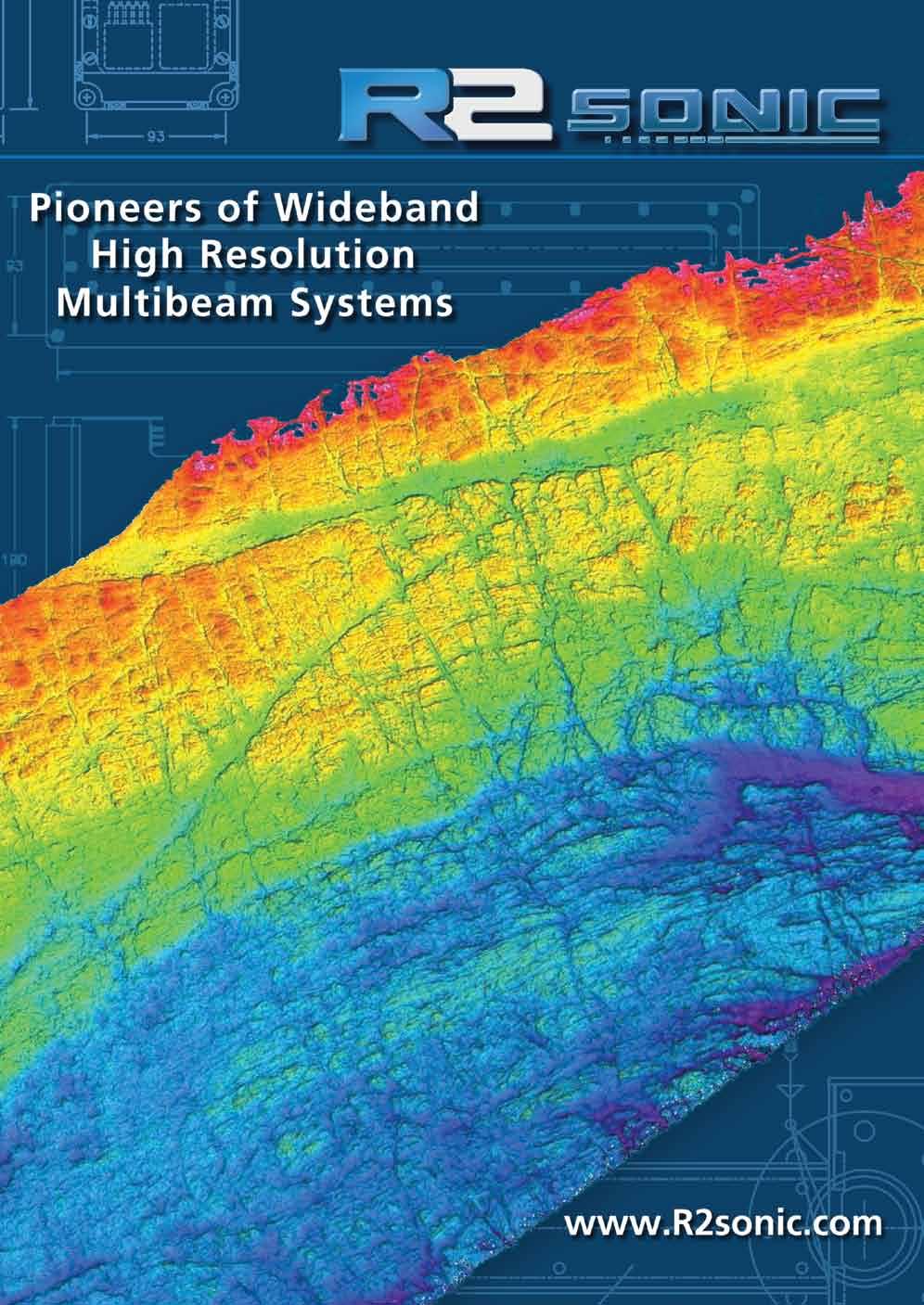
6 Cover Image: Produced by Sonic 2024/Hypack, edited with IVS Fledermaus software, offshore UK in 8-20m water depths. Image courtesy of Aspect Land & Hydrographic Surveys, UK. Sonar Options Snippets & TruePix Backscatter Imagery Raw Water Column Data Switchable Forward Looking Sonar Ultra High Resolution Sediment Profiler 3000m Immersion Depth Rating Integrated Inertial Navigation System (INS) Mounting Hardware & Assemblies Antifouling Coating Protection Corporate Office R2Sonic, LLC 5307 Industrial Oaks Blvd. Suite 120 Austin, TX Voice: Feb 2014
Pioneers of Wideband High Resolution Multibeam Systems
 Pioneers of Wideband High Resolution Multibeam Systems W W W. R 2 S O N I C. C O M Systems Overview The R2Sonic Sonic Series are the world s first true wideband high resolution Motion Heading SV GPS shallow
KONGSBERG seafloor-mapping echosounders
 KONGSBERG seafloor-mapping echosounders Berit Horvei WORLD CLASS through people, technology and dedication AGENDA Historical overview EM series Multibeam echosounder and Subbottom profiler Topside software.
CALTRANS BATHYMETRIC SURVEY VICINITY OF YERBA BUENA ISLAND AND OAKLAND MOLE ALONG SFOBB SAN FRANCISCO BAY
 FUGRO PELAGOS, INC. CALTRANS BATHYMETRIC SURVEY VICINITY OF YERBA BUENA ISLAND AND OAKLAND MOLE ALONG SFOBB SAN FRANCISCO BAY CALTRANS CONTRACT 59A0053 Survey Period: February 25 th March 1 st, 2013 Report
SONARMITE v4.0 MTX sweep version - PORTABLE BLUETOOTH ECHO SOUNDER
 SONARMITE v4.0 MTX sweep version - PORTABLE BLUETOOTH ECHO SOUNDER Introduction The SonarMite Echo Sounder was the result of nearly two years research and development to further extend the boundaries of
Teledyne Marine Acoustic Imagining
 RESON SeaBat high performance sonars for long range object detection and MCM applications Navigation, object avoidance & up close inspection with BlueView Greg Probst Sales Manager, Defense Teledyne Marine
Multi-Beam Echo Sounders do beam width, frequency, number of beams matter? James Williams Managing Director
 Multi-Beam Echo Sounders do beam width, frequency, number of beams matter? James Williams Managing Director 1 Swathe Services We offer Product Sales, Equipment Rental and Personnel Deployment Our latest
SYSTEM 5900 SIDE SCAN SONAR
 SYSTEM 5900 SIDE SCAN SONAR HIGH-RESOLUTION, DYNAMICALLY FOCUSED, MULTI-BEAM SIDE SCAN SONAR Klein Marine System s 5900 sonar is the flagship in our exclusive family of multi-beam technology-based side
The Oil & Gas Industry Requirements for Marine Robots of the 21st century
 The Oil & Gas Industry Requirements for Marine Robots of the 21st century www.eninorge.no Laura Gallimberti 20.06.2014 1 Outline Introduction: fast technology growth Overview underwater vehicles development
Tritech International Vehicle Sonar Developments
 Tritech International Vehicle Sonar Developments Mike Broadbent Business Development Manager Oceanology 2012 - UUVS Overview About Tritech Mechanical Scanning Sonar - Improving the performance High Speed
Now add true dual channel side scan and Sub Bottom profile to your hydrographic surveys.
 New ROSS 4900 Series Side Scan Sonar and Sub Bottom profiler. Now add true dual channel side scan and Sub Bottom profile to your hydrographic surveys. Laboratories, well known for its line of multi channel
PRINCIPLE OF SEISMIC SURVEY
 PRINCIPLE OF SEISMIC SURVEY MARINE INSTITUTE Galway, Ireland 29th April 2016 Laurent MATTIO Contents 2 Principle of seismic survey Objective of seismic survey Acquisition chain Wave propagation Different
Seafloor Mapping Using Interferometric Sonars: Advances in Technology and Techniques
 Seafloor Mapping Using Interferometric Sonars: Advances in Technology and Techniques Tom Hiller, Advanced Products Manager, GeoAcoustics Ltd. WORLD CLASS through people, technology and dedication Brest,
Ultra Electronics Integrated Sonar Suite
 Sonar Systems Crown Copyright Ultra Electronics Integrated Sonar Suite COMPREHENSIVE NETWORK CENTRIC WARFARE SYSTEM COMPRISING: HULL-MOUNT SONAR VARIABLE DEPTH SONAR TORPEDO DEFENCE INNOVATION PERFORMANCE
USBL positioning and communication systems. Applications
 USBL positioning and communication systems Offering a powerful USBL transceiver functionality with full benefits of an S2C technology communication link Applications Positioning of offshore equipment >
WASSP S3 MULTIBEAM FOR SURVEY & MAPPING EXPLORE IT ALL
 WASSP S3 EXPLORE IT ALL DISCOVER A NEW WORLD WITH THE LATEST INNOVATION FROM WASSP Outstanding performance, versatility and value. That s what you expect and exactly what you get with the new S3 sounder
Progress Report. Mohammadtaghi G. Poshtmashhadi. Supervisor: Professor António M. Pascoal
 Progress Report Mohammadtaghi G. Poshtmashhadi Supervisor: Professor António M. Pascoal OceaNet meeting presentation April 2017 2 Work program Main Research Topic Autonomous Marine Vehicle Control and
Kongsberg Maritime Product overview
 Kongsberg Maritime Product overview / 1 / 1-Nov-12 Frequency Range Coverage 125,250,500kHz 0.5-200m 12xD 200-400kHz 0.5-500m 5.5xD / 140-200 deg 300 khz 0.5-270m 4-10xD / 130-200 deg 70-100 khz 3-2000m
Operation Manual V4.1
 SONIC 2024/2022 BROADBAND MULTIBEAM ECHOSOUNDERS Operation Manual V4.1 Part No. 96000001 Version 4.1 Rev r000 Part No. 96000001 Page 2 of 176 COPYRIGHT NOTICE Copyright 2008, R2Sonic LLC. All rights reserved
Inertial Navigation System
 Apogee Series ULTIMATE ACCURACY MEMS Inertial Navigation System INS MRU AHRS ITAR Free 0.005 RMS Motion Sensing & Georeferencing APOGEE SERIES makes high accuracy affordable for all surveying companies.
A 3D, FORWARD-LOOKING, PHASED ARRAY, OBSTACLE AVOIDANCE SONAR FOR AUTONOMOUS UNDERWATER VEHICLES
 A 3D, FORWARD-LOOKING, PHASED ARRAY, OBSTACLE AVOIDANCE SONAR FOR AUTONOMOUS UNDERWATER VEHICLES Matthew J. Zimmerman Vice President of Engineering FarSounder, Inc. 95 Hathaway Center, Providence, RI 02907
CLEARER. DEEPER. BROADER. Pocket / Keel-Mount GAME CHANGING TECHNOLOGY.
 CHIRP Upgrade Your Sounder to a Serious Fishfinding Machine! Only possible with the use of an AIRMAR broadband transducer. CHIRP TECHNOLOGY 5 to 10 times greater detail and resolution 10 to 1,000 times
CORE B265LH (Low & High-Frequency)
") CHIRP Upgrade Your Sounder to a Serious Fishfinding Machine! Only possible with the use of an AIRMAR broadband transducer. CHIRP TECHNOLOGY 5 to 10 times greater detail and resolution 10 to 1,000 times
CHIRP Upgrade Your Sounder to a Serious Fishfinding Machine! Only possible with the use of an AIRMAR broadband transducer. CHIRP TECHNOLOGY 5 to 10 times greater detail and resolution 10 to 1,000 times
Increased Safety and Efficiency using 3D Real-Time Sonar for Subsea Construction
 Increased Safety and Efficiency using 3D Real-Time Sonar for Subsea Construction Chief Technology Officer CodaOctopus Products, Ltd. Booth A33a 2D, 3D and Real-Time 3D (4D) Sonars? 2D Imaging 3D Multibeam
USBL positioning and communication SyStEmS. product information GUidE
 USBL positioning and communication SyStEmS product information GUidE evologics s2c R usbl - series underwater positioning and communication systems EvoLogics S2CR USBL is a series of combined positioning
GeoSwath Plus Wide swath bathymetry and georeferenced side scan
 GeoSwath Plus Wide swath bathymetry and georeferenced side scan www.geoacoustics.com GeoSwath Plus Wide Swath Bathymetry and co-registered georeferenced side scan system We maximise marine performance
Survey Sensors. 18/04/2018 Danny Wake Group Surveyor i-tech Services
 Survey Sensors 18/04/2018 Danny Wake Group Surveyor i-tech Services What do we need sensors for? For pure hydrographic surveying: Depth measurements Hazard identification Seabed composition Tides & currents
Underwater Acoustic Communication and Positioning State of the Art and New Uses
 Underwater Acoustic Communication and Positioning State of the Art and New Uses Radio signals Work only on very short distances Salty water particularly problematic No underwater GPS Cables Too heavy,
Side-Scan Sonar Presentation STS
 Training Module Side-Scan Sonar Presentation STS SIDE-SCAN SONAR SAFETY Training Module Content: This module includes information on: Types of Side-Scan Benefits and Disadvantages System Configuration
Teledyne Marine Oil and Gas.
 Oil and Gas www.teledynemarine.com/energy Applications in Oil and Gas Teledyne Marine encompasses over 20 brands that offer innovative, highly reliable technology spanning the life cycle of an oil field,
Research Vessel Technical Enhancement Committee (RVTEC) November 2009 Meeting ISS - Integrated Survey Systems
 November 2009 Meeting ISS - Integrated Survey Systems") Research Vessel Technical Enhancement Committee (RVTEC) November 2009 Meeting ISS - Integrated Survey Systems John Kiernan, P.E. SAIC - Marine Science and Technology Division ISS-2000 Integrated Survey
Research Vessel Technical Enhancement Committee (RVTEC) November 2009 Meeting ISS - Integrated Survey Systems John Kiernan, P.E. SAIC - Marine Science and Technology Division ISS-2000 Integrated Survey
1 Introduction integrated 3D sonar system for underwater inspection applications
 1 Introduction The Underwater Inspection System (UIS TM ) is an integrated 3D sonar system for underwater inspection applications, specifically port and harbor construction, maintenance, port expansion,
Experiences with Hydrographic Data Budgets Using a Low-logistics AUV Platform. Thomas Hiller Teledyne Marine Systems
 Experiences with Hydrographic Data Budgets Using a Low-logistics AUV Platform Thomas Hiller Teledyne Marine Systems 1 Teledyne Marine Systems Strategic Business Units 2 What is the Gavia? The Gavia is
Multibeam Echosounder Metadata and Quality Statistics
 Multibeam Echosounder Metadata and Quality Statistics Dave Mann, Survey Support Manager, Gardline Geosurvey Gardline MBES Systems Sea Explorer EM1002 RV Triton EM1002(S) Ocean Seeker EM1002(S) Ocean Endeavour
global acoustic positioning system GAPS usbl acoustic with integrated INS positioning system Ixsea Oceano GAPS page 1
 global acoustic positioning system usbl acoustic positioning system with integrated INS positioning system page 1 THE MERGER OF INERTIAL AND UNDERWATER ACOUSTIC TECHNOLOGIES is a unique Global Acoustic
Three-dimensional investigation of buried structures with multi-transducer parametric sub-bottom profiler as part of hydrographical applications
 Three-dimensional investigation of buried structures with multi-transducer parametric sub-bottom profiler as part Jens LOWAG, Germany, Dr. Jens WUNDERLICH, Germany, Peter HUEMBS, Germany Key words: parametric,
SONOBOT AUTONOMOUS HYDROGRAPHIC SURVEY VEHICLE PRODUCT INFORMATION GUIDE
 SONOBOT AUTONOMOUS HYDROGRAPHIC SURVEY VEHICLE PRODUCT INFORMATION GUIDE EvoLogics SONOBOT: Autonomous Surface Vehicle for Hydrographic Surveys High Precision Differential GPS for high-accuracy cartography
Kordil Surveying & Engineering Services
 Kordil Surveying & Engineering Services About Kordil Kordil Surveying & Engineering Ltd. Co. in short Kordil is an all in one surveying company providing service from Turkey. Hydrography, Oceanography
Ranger USBL Acoustic Positioning System for DP Reference and Survey
 Acoustic Positioning System for DP Reference and Survey cc 545000m N 544990m 544980m 544970m 6027910m 6027900m W 6027890m 6027880m S Contents Introduction 01 Ranger USBL System Overview 02 Ranger USBL
SIGNAL PROCESSING ALGORITHMS FOR HIGH-PRECISION NAVIGATION AND GUIDANCE FOR UNDERWATER AUTONOMOUS SENSING SYSTEMS
 SIGNAL PROCESSING ALGORITHMS FOR HIGH-PRECISION NAVIGATION AND GUIDANCE FOR UNDERWATER AUTONOMOUS SENSING SYSTEMS Daniel Doonan, Chris Utley, and Hua Lee Imaging Systems Laboratory Department of Electrical
AN ACOUSTIC PIPELINE TRACKING AND SURVEY SYSTEM FOR THE OFFSHORE
 AN ACOUSTIC PIPELINE TRACKING AND SURVEY SYSTEM FOR THE OFFSHORE Nico Roosnek Roosnek Research & Development Vlaskamp 92 2592 AC The Hague The Netherlands e-mail: nico@roosnek.nl Abstract: Acoustic pipeline
OFFSHORE ANALYSIS & RESEARCH SOLUTIONS HOUSTON PETROLEUM SURVEYORS GROUP PERSONNEL DATA PROCESSING PARTNERSHIPS
 OFFSHORE ANALYSIS & RESEARCH SOLUTIONS HOUSTON PETROLEUM SURVEYORS GROUP KEEPING YOUR PROJECTS IN MOTION OARS-HPSG combines the experience of two highly complementary organizations providing expanded capabilities,
Pipeline Inspection and Environmental Monitoring Using AUVs
 Pipeline Inspection and Environmental Monitoring Using AUVs Bjørn Jalving, Bjørn Gjelstad, Kongsberg Maritime AUV Workshop, IRIS Biomiljø, 7 8 September 2011 WORLD CLASS through people, technology and
EK60. SCIENTIFIC SOUNDER SCIENTIFIC ECHO SOUNDER
 EK60 SCIENTIFIC ECHO SOUNDER HIGH DYNAMIC RANGE RAW DATA RECORDING LOW SELF NOISE HIGH PING RATE MULTI FREQUENCY APPLICATION FOR SPECIES ID SEVERAL FREQUENCIES COVERING SAME SAMPLE VOLUME REMOTE CONTROL
Subsea Monitoring & Mapping
 Subsea Monitoring & Mapping Arnold Hechanova & Dave Fraser ITAC Meeting 2016 Woods Hole Oceanographic Institute, MA Overview Program Objective: Develop sensors to detect loss of containment subsea and
USACE Norfolk District S/V Adams II. Norbit WBMS Hull Mount
 USACE Norfolk District S/V Adams II Technical refresh White Glove Delivery Norbit WBMS Hull Mount Original Hull Mounted System, Reson 8101 The ADAMS II: launched in 1997 with a Reson 8101 hull mounted
MINE SEARCH MISSION PLANNING FOR HIGH DEFINITION SONAR SYSTEM - SELECTION OF SPACE IMAGING EQUIPMENT FOR A SMALL AUV DOROTA ŁUKASZEWICZ, LECH ROWIŃSKI
 MINE SEARCH MISSION PLANNING FOR HIGH DEFINITION SONAR SYSTEM - SELECTION OF SPACE IMAGING EQUIPMENT FOR A SMALL AUV DOROTA ŁUKASZEWICZ, LECH ROWIŃSKI Gdansk University of Technology Faculty of Ocean Engineering
Quick start guide M3 Sonar
 Quick start guide M3 Sonar Creating an image mosaic using Photoshop and Geographic Imager 2013, Kongsberg Mesotech Ltd. 922-20007005 M3 Sonar Quick start guide Creating an image mosaic using Photoshop
LBL POSITIONING AND COMMUNICATION SYSTEMS PRODUCT INFORMATION GUIDE
 LBL POSITIONING AND COMMUNICATION SYSTEMS PRODUCT INFORMATION GUIDE EvoLogics S2C LBL Underwater Positioning and Communication Systems EvoLogics LBL systems bring the benefi ts of long baseline (LBL) acoustic
Motion Reference Units
 Motion Reference Units MRU Datasheet Rev. 1.3 IP-67 sealed 5% / 5 cm Heave accuracy 0.03 m/sec Velocity accuracy 0.05 deg Pitch and Roll accuracy 0.005 m/sec2 Acceleration accuracy 0.0002 deg/sec Angular
Applications. > > Oil & Gas. > > RoVs and auvs. > > Oceanography. > > Monitoring stations. > > Seismic. > > Networks and relay chains
 Underwater acoustic Modems EvoLogics S2CR - series underwater acoustic modems provide full-duplex digital communication delivering an excellent performance, resistant to the challenges of the dynamic subsea
EM 710. Multibeam echo sounder
 EM 710 Multibeam echo sounder EM 710 Multibeam echo sounder Product description This document presents a brief technical description of the EM 710 multibeam echo sounder. About this document Rev Date
SeaCat SwapHead Field-Exchangeable Sensor Technology. Product Description (Part 2 of 3)
") SeaCat SwapHead Field-Exchangeable Sensor Technology Product Description (Part 2 of 3) SeaCat SwapHead Introduction SeaCat is the Swiss army knife of underwater survey and inspection operations. It can
SeaCat SwapHead Field-Exchangeable Sensor Technology Product Description (Part 2 of 3) SeaCat SwapHead Introduction SeaCat is the Swiss army knife of underwater survey and inspection operations. It can
SeaWATCH ADCP. Self-Contained 300 khz / 600 khz / 1200 khz
 SeaWATCH ADCP Self-Contained 300 khz / 600 khz / 1200 khz The Rowe Technologies SeaWATCH product family is the most versatile self-contained Acoustic Doppler Current Profilers (ADCPs) and represent the
INTRODUCING AN OPERATIONAL MULTI-BEAM ARRAY SONAR
 INTRODUCING AN OPERATIONAL MULTI-BEAM ARRAY SONAR b y Morris F. G l e n n Oceanographer U.S. Naval Oceanographic Office PRECIS The Multi-Beam Array Sonar Survey System is a revolutionary new bathymetric
Sonars TECHNOLOGY FOR SUSTAINABLE FISHERIES
 Sonars TECHNOLOGY FOR SUSTAINABLE FISHERIES SIMRAD SU90 SONAR The SU90 Sonar is made with no compromises. The number of channels has been increased by 50% compared to the SX90 Sonar giving the sonar an
Hybrid system using both USBL and LBL for shallow waters
 OI2013 Underwater Positioning & Communication Hybrid system using both USBL and LBL for shallow waters Nicolas LARUELLE Sales Manager at OSEAN September 4th,2013 OI2013 Page 1 OVERVIEW SPECIFICATIONS PRINCIPLES
Old House Channel Bathymetric and Side Scan Survey
 FIELD RESEARCH FACILITY DUCK, NC Old House Channel Bathymetric and Side Scan Survey COASTAL AND HYDRAULICS LABORATORY FIELD DATA COLLECTION AND ANALYSIS BRANCH Michael Forte December 2009 View looking
Multibeam data quality assurance at Genavir. Karine Abel Michaux
 Multibeam data quality assurance at Genavir Hervé Bisquay hbisquay@genavir.fr Karine Abel Michaux kabelmic@genavir.fr Pascal Viollette pviollette@genavir.fr GENAVIR Genavir is the operator of the civilian
MARKSMAN DP-INS DYNAMIC POSITIONING INERTIAL REFERENCE SYSTEM
 cc MARKSMAN DP-INS DYNAMIC POSITIONING INERTIAL REFERENCE SYSTEM Sonardyne s Marksman DP-INS is an advanced navigation-based Position Measuring Equipment (PME) source for dynamically positioned (DP) rigs.
Teledyne Oil & Gas Innovation and Subsea Reliability
 A Member of Innovation and Subsea Reliability www.teledyneoilandgas.com Technologies A Member of Seismic Instruments Imaging Vehicles Photo Courtesy BMT has been proudly serving the oil and gas industry
Inertial Systems. Ekinox 2 Series TACTICAL GRADE MEMS. Motion Sensing & Navigation IMU AHRS MRU INS VG
 Ekinox 2 Series TACTICAL GRADE MEMS Inertial Systems IMU AHRS MRU INS VG ITAR Free 0.02 RMS Motion Sensing & Navigation AEROSPACE GROUND MARINE EKINOX 2 SERIES R&D specialists usually compromise between
Using synthetic aperture sonar as an effective hydrographic survey tool
 Using synthetic aperture sonar as an effective hydrographic survey tool Andy Hoggarth 1 (presenter), Karl Kenny 2 1. CARIS 1, 115 Waggoners Lane, Fredericton, NB CANADA E3B 2L4, 506-458-8533 2. Kraken
Inertial Systems. Ekinox 2 Series TACTICAL GRADE MEMS. Motion Sensing & Navigation IMU AHRS MRU INS VG
 Ekinox 2 Series TACTICAL GRADE MEMS Inertial Systems IMU AHRS MRU INS VG ITAR Free 0.02 RMS Motion Sensing & Navigation AEROSPACE GROUND MARINE EKINOX 2 SERIES R&D specialists usually compromise between
UNDERWATER SCIENCE. Single Beam Systems TECHNOLOGY FOR SUSTAINABLE FISHERIES
 UNDERWATER SCIENCE Single Beam Systems TECHNOLOGY FOR SUSTAINABLE FISHERIES SIMRAD EK SYSTEMS EK is our common name for all single beam echo sounders designed for research applications. The first EK sounder
Synthesis of acoustic images of underwater targets
 FACULDADE DE ENGENHARIA DA UNIVERSIDADE DO PORTO Synthesis of acoustic images of underwater targets Duarte Nuno Reimão Borges Lopes Silva PREPARATION FOR THE MSC DISSERTATION Master in Electrical and Computers
SONOBOT AUTONOMOUS HYDROGRAPHIC SURVEY VEHICLE PRODUCT INFORMATION GUIDE
 SONOBOT AUTONOMOUS HYDROGRAPHIC SURVEY VEHICLE PRODUCT INFORMATION GUIDE EvoLogics Sonobot an autonomous unmanned surface vehicle for hydrographic surveys High Precision Differential GPS for high-accuracy
Underwater GPS User Manual
 Underwater GPS Document number W-DN-17002-2 Project Classification - Rev Prepared by Checked by Approved by Short description 1 2017-08-03 O. Skisland Initial 2 O. Skisland Minor changes References [1]
Echosounders TECHNOLOGY FOR SUSTAINABLE FISHERIES
 Echosounders TECHNOLOGY FOR SUSTAINABLE FISHERIES ES80 ECHOSOUNDER SIMRAD has manufactured fishfinders for more than 70 years and has 25 years of experience using Split beam technology. The first Split
Handling Interferometric Data: Streamlining the Processing Flow
 Handling Interferometric Data: Streamlining the Processing Flow Paper 5 at Hydro8, 4 th November 2008 Tom Hiller, Advanced Products Manager, GeoAcoustics Ltd. WORLD CLASS through people, technology and
CORE B265LH (Low & High-Frequency)
") CHIRP Upgrade Your Sounder to a Serious Fishfinding Machine! Only possible with the use of an AIRMAR broadband transducer. CHIRP TECHNOLOGY 5 to 10 times greater detail and resolution 10 to 1,000 times
CHIRP Upgrade Your Sounder to a Serious Fishfinding Machine! Only possible with the use of an AIRMAR broadband transducer. CHIRP TECHNOLOGY 5 to 10 times greater detail and resolution 10 to 1,000 times
The Signature VM package delivers vessel-mounted AD2CP capabilities based on present-day technology
 The package delivers vessel-mounted AD2CP capabilities based on present-day technology Until now, ADCP current surveys have been complex and time-consuming processes. A successful current survey depends
Mean currents and turbulence, plus wave height, direction and ice tracking
 Mean currents and turbulence, plus wave height, direction and ice tracking The ADCP is designed for flexibility. It measures current profiles at up to 8 Hz sampling frequency. It can also measure direct
General Catalog UNDERWATER SCIENCE PRODUCTS TECHNOLOGY FOR SUSTAINABLE FISHERIES
 General Catalog UNDERWATER SCIENCE PRODUCTS 1947-2017 TECHNOLOGY FOR SUSTAINABLE FISHERIES TRANSDUCERS Transducers are the core of all SIMRAD products. The ability to efficiently convert the digital signal
Subsea UK 2014 Developments in ROV Technology
 Subsea UK 2014 Developments in ROV Technology Smarter Technologies Enable Smarter Platforms (ROVs) => Improved Offshore Operations Nick Lawson What does an ROV do? Any ROVs primary function is to provide
THE USE OF THE SOFTWARE COMMUNICATIONS ARCHITECTURE (SCA) FOR SONAR AND UNDERWATER COMMUNICATION APPLICATIONS
 FOR SONAR AND UNDERWATER COMMUNICATION APPLICATIONS") THE USE OF THE SOFTWARE COMMUNICATIONS ARCHITECTURE (SCA) FOR SONAR AND UNDERWATER COMMUNICATION APPLICATIONS Emma Jones (SEA Group Ltd, Bath, UK. emma.jones@sea.co.uk) ABSTRACT The Communications Architecture
THE USE OF THE SOFTWARE COMMUNICATIONS ARCHITECTURE (SCA) FOR SONAR AND UNDERWATER COMMUNICATION APPLICATIONS Emma Jones (SEA Group Ltd, Bath, UK. emma.jones@sea.co.uk) ABSTRACT The Communications Architecture
Inertial Systems. Ekinox Series TACTICAL GRADE MEMS. Motion Sensing & Navigation IMU AHRS MRU INS VG
 Ekinox Series TACTICAL GRADE MEMS Inertial Systems IMU AHRS MRU INS VG ITAR Free 0.05 RMS Motion Sensing & Navigation AEROSPACE GROUND MARINE EKINOX SERIES R&D specialists usually compromise between high
Advances in Antenna Measurement Instrumentation and Systems
 Advances in Antenna Measurement Instrumentation and Systems Steven R. Nichols, Roger Dygert, David Wayne MI Technologies Suwanee, Georgia, USA Abstract Since the early days of antenna pattern recorders,
Advanced Soldier Monitoring and Tracking System Using GPS and GSM Introduction
 Advanced Soldier Monitoring and Tracking System Using GPS and GSM Introduction The infantry soldier of tomorrow promises to be one of the most technologically advanced modern warfare has ever seen. Around
Object Detection for Underwater Port Security
 Object Detection for Underwater Port Security Dr. Lloyd Huff LCHUFF CONSULTANCY,LLC Mr. John Thomas TRITON IMAGING,INC Shallow Survey 2012 February 22, 2012 INTRODUCTION I am glad to be here today to make
ASO 713/723 Hull-Mounted Active Sonar
 ASO 713/723 Hull-Mounted Active Sonar ASO Anti-Submarine Warfare... a sound decision ATLAS ELEKTRONIK Naval Underwater Theatre ASO The ATLAS ELEKTRONIK Hull-Mounted Sonar (HMS) systems ASO 713/723 belong
Construction Survey Positioning Systems Wideband Fusion LBL and USBL
 cc Construction Survey Positioning Systems Wideband Fusion LBL and USBL Contents Introduction 01 Fusion USBL 02 Fusion USBL System Specifications 05 Fusion LBL 06 Fusion LBL System Specifications 09 Precise,
Calibration of multibeam echo sounders: a comparison between two methodologies
 University of New Hampshire University of New Hampshire Scholars' Repository Center for Coastal and Ocean Mapping Center for Coastal and Ocean Mapping 11-2012 Calibration of multibeam echo sounders: a
SAAB SEA POWER CAPABILITIES FOR MALAYSIA AND APAC LIMA Robert Hewson Vice President Head of Communications, Saab Asia Pacific
 1 SAAB SEA POWER CAPABILITIES FOR MALAYSIA AND APAC LIMA 2017 Robert Hewson Vice President Head of Communications, Saab Asia Pacific This document and the information contained herein is the property of
Underwater GPS User Manual
 Underwater GPS Document number W-DN-17002-3 Project Classification - Rev Prepared by Checked by Approved by Short description 1 2017-08-03 T. Trøite O. Skisland T. Trøite Initial 2 2017-08-04 T. Trøite
Ongoing Developments in Side Scan Sonar The pursuit of better Range, Resolution and Speed
 Ongoing Developments in Side Scan Sonar The pursuit of better Range, Resolution and Speed Nick Lawrence EdgeTech Advances in Seafloor-mapping Sonar Conference 30 th November 2009 Company Profile EdgeTech
Team members: Christopher A. Urquhart Oluwaseyitan Joshua Durodola Nathaniel Sims
 Team members: Christopher A. Urquhart Oluwaseyitan Joshua Durodola Nathaniel Sims Background Problem Formulation Current State of Art Solution Approach Systematic Approach Task and Project Management Costs
Motion Reference Units
 Motion Reference Units MRU IP-67 sealed 5% / 5 cm Heave accuracy 0.03 m/sec Velocity accuracy 0.05 deg Pitch and Roll accuracy 0.005 m/sec 2 Acceleration accuracy 0.0002 deg/sec Angular rate accuracy NMEA
CLEARER. DEEPER. BROADER. In-Hull GAME CHANGING TECHNOLOGY.
 CHIRP Upgrade Your Sounder to a Serious Fishfinding Machine! Only possible with the use of an AIRMAR broadband transducer. CHIRP TECHNOLOGY 5 to 10 times greater detail and resolution 10 to 1,000 times
Inertial Navigation System
 Apogee Marine Series ULTIMATE ACCURACY MEMS Inertial Navigation System INS MRU AHRS ITAR Free 0.005 RMS Navigation, Motion & Heave Sensing APOGEE SERIES makes high accuracy affordable for all surveying
Sonar advancements for coastal and maritime surveys
 ConférenceMéditerranéenneCôtièreetMaritime EDITION1,HAMMAMET,TUNISIE(2009) CoastalandMaritimeMediterraneanConference Disponibleenligne http://www.paralia.fr Availableonline Sonar advancements for coastal
Modeling of underwater sonar barriers
 Acoustics 8 Paris Modeling of underwater sonar barriers A. Elminowicz and L. Zajaczkowski R&D Marine Technology Centre, Ul. Dickmana 62, 81-19 Gdynia, Poland andrzeje@ctm.gdynia.pl 3429 Acoustics 8 Paris
SWAMSI: Bistatic CSAS and Target Echo Studies
 SWAMSI: Bistatic CSAS and Target Echo Studies Kent Scarbrough Advanced Technology Laboratory Applied Research Laboratories The University of Texas at Austin P.O. Box 8029 Austin, TX 78713-8029 phone: (512)
Positioning Small AUVs for Deeper Water Surveys Using Inverted USBL
 Positioning Small AUVs for Deeper Water Surveys Using Inverted USBL Presented at Hydro12, Rotterdam, November 2012 Dr. T.M. Hiller, thiller@teledyne.com Overview Introduction to Gavia AUV Gavia Acoustic
Acoustics Digital, Spread Spectrum, DSP, Wideband What does this mean for Real World DP Operations? Jonathan Davis Sonardyne Inc
 Subsea Positioning & Communications Acoustics Digital, Spread Spectrum, DSP, Wideband What does this mean for Real World DP Operations? Jonathan Davis Sonardyne Inc Outline Introduction Signal Processing
MARINE SURVEY MARINE SURVEY 1
 MARINE SURVEY MARINE SURVEY 1 MARINE SURVEY 2 MARINE SURVEY MARINE SURVEY 3 SOLUTIONS 4 MARINE SURVEY MARINE SURVEY 5 MARINE SURVEY 5 ixblue stands as a global leader in the design and manufacturing of
Dimensional Survey Company
 Dimensional Survey Company Services Anko Bluepix was founded in 2016 by experienced engineers, each a specialist within different segments of the survey business. Even though Anko Bluepix is a young company
Simrad SX90 Long range high definition sonar system
 Simrad SX90 Long range high definition sonar system 360 omnidirectional sonar 90 vertical tip mode 20 to 30 KHz operational frequency Narrow beams Selectable beam width Hyperbolic FM Large dynamic range
Autonomous Underwater Vehicles
 Autonomous Underwater Vehicles New Autonomous Underwater Vehicle technology development at WHOI to support the growing needs of scientific, commercial and military undersea search and survey operations
w w w. s e i s m i c i n s t r u m e n t s. c o m Page 1
 w w w. s e i s m i c i n s t r u m e n t s. c o m Page 1 Seismic Instruments offers three different configurations of data acquisition system (Cabled, Cable-Free and Mixed) in a wide range of options,
Operation Manual V3.0
 SONIC 2020 BROADBAND MULTIBEAM ECHOSOUNDER Operation Manual V3.0 Revision 002 (15May2014) Part No. 96000005 Version 3.0 Rev r002 Part No. 96000005 Page 2 of 196 COPYRIGHT NOTICE Copyright 2013, R2Sonic