Underwater Acoustic Communication and Positioning State of the Art and New Uses
|
|
|
- Maud Shaw
- 5 years ago
- Views:
Transcription


1 Underwater Acoustic Communication and Positioning State of the Art and New Uses


2 Radio signals Work only on very short distances Salty water particularly problematic No underwater GPS Cables Too heavy, bulky, for longer distances and depths Impractical for small AUV and ROV applications Can be broken by passing ship Acoustic communication Worked only under ideal conditions Prone to interferances from noise High energy consumption Environmental concerns
3 Signal arrives as a multitude of overlapping echoes at the receiver Highly dynamic situation, changes can occur within seconds Caused by reflections in the surface sea-floor, density and temperature variations


 High precision measurements")
4 Advantages S2C: Ultrawide band signals with continous frequency changes Multipath echoes can be separated with S2C s signal compression High signal gain at the receiver end More available bandwidth Energy efficient Environmentally friendy (very low energy content per frequency cell) High precision measurements simultaneously (range and speed)
5 Fast and Self adapting Signal parameters optimized with each transmission Achieve the best transmission at given conditions without sacrificing reliability Advanced data management for efficient acoustic communication Optional to have multiple channels Transparent link to the end-user: Automatic error correction Maintain packet order Extended functionality Use the same signals for accurate positioning with an integrated ultra-short baseline (USBL) antenna or long-baseline (LBL) antenna Basis for new sonar development Networking options: Relaying for longer distances Broadcasting Special protocols to take the transmission delays into consideration Meshes with automatic re-routing and increased reliability
 Continuous improvements for")
6 Combined data transmission and positioning Acoustic communications and positioning emulator Communication networks Technological evolution towards reduction in size and power consumption Researcher and developer tools (Sandbox, digital/analog Wet-End) Continuous improvements for reliability


7 Developer tools White Line Science Edition Sandbox included, with up to 64GB space for own development TCL/Expect, GCC Toolchain NS2 Framework SUNRISE Driver Ideal for protocol development and testing Wet-End Digital or analog input Testbed for signal modulation scheme testing


8 S2C acoustic modem EMULATOR PC Sensor Software Modem PC Sensor Software Modem Emulator PC ROV/AUV Software Software Modem
9 S2C acoustic modem emulator structure: data-link layer emulator Linux kernel module that controls the data exchange between the data-link layer and the physical layer physical layer simulator acoustic channel simulator What is simulated? signal propagation delays data packet collision detection packet synchronization errors time difference of arrivals on the USBL grid elements movement of the virtual modems (in development)

10


11 Baikal Deep Underwater Neutrino Telescope (BDUNT) at a depth of 1200 m in the Baikal lake Requires careful Calibration of the Sensor positions 2010 by using S2C Technology: Accuracy achieved: 5 mm

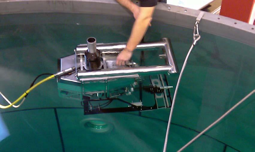
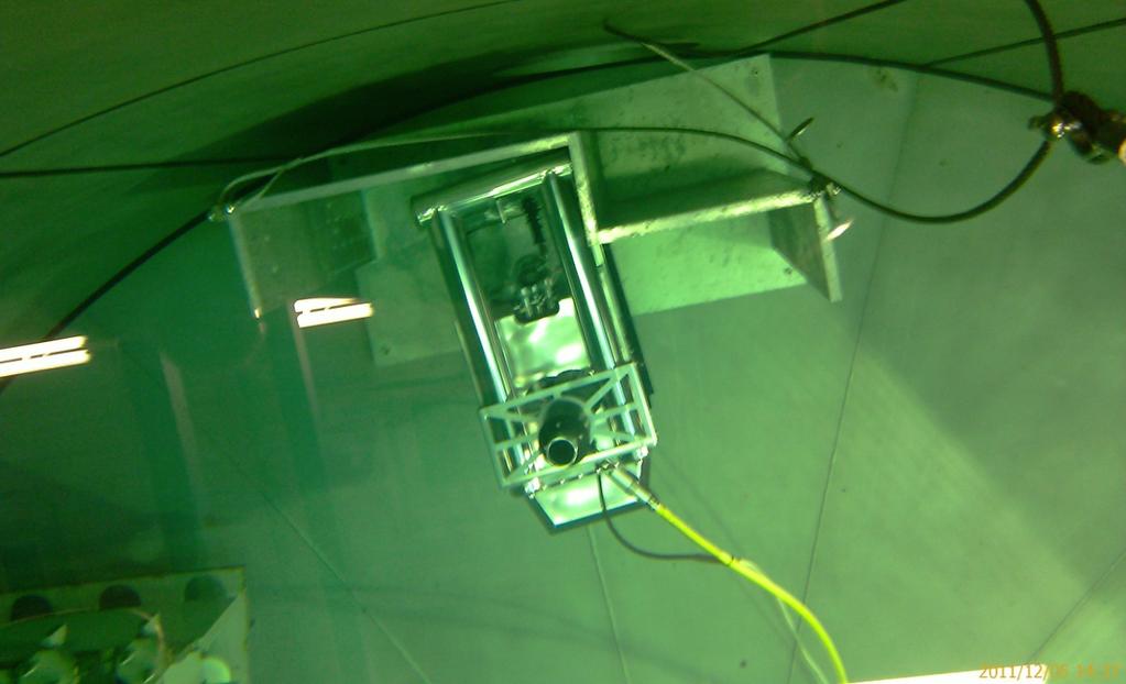
12 Facility AREVA, pool test
, or angular")
13 1.5 Z, m X, m Y, m Position estimations accuracy: 0,07% of the slant range (Drms), or angular deviation: 0,04 from the correct attitude


14 RS Maria S. Merian, Atlantic ocean, 6000 m DNS project, Germany
15 UBLS positioning results short range (near to bottom) long range (open water) Position estimations precisions: short range (200 m): 0,085 % of the slant range (Drms), long range (2 km): 0,117 % of the slant range (Drms),
16 Conclusions: 1. The accuracy (Drms) of the combined USBL positioning and communication system stays about 0.1 % of the slant range. At a distance of 100 m between the USBL transceiver and the transponder the positioning error stays under 10 cm. 2. Data exchange with bitrates of 10 kbps along with positioning provides additional control opportunities, Vehicle navigation in real-time mode (acoustic commands) etc.


17 UW Networks Multi-Sensors Multi-Channel - Systems S2C R-Series LBL / USBL Positioning S2C Sonar-Technique Mechanic Control Acoustic Releasers etc. Data-Logger / Monitoring Systems Modular ICT Systems
18
USBL positioning and communication SyStEmS. product information GUidE
 USBL positioning and communication SyStEmS product information GUidE evologics s2c R usbl - series underwater positioning and communication systems EvoLogics S2CR USBL is a series of combined positioning
USBL positioning and communication systems. Applications
 USBL positioning and communication systems Offering a powerful USBL transceiver functionality with full benefits of an S2C technology communication link Applications Positioning of offshore equipment >
Applications. > > Oil & Gas. > > RoVs and auvs. > > Oceanography. > > Monitoring stations. > > Seismic. > > Networks and relay chains
 Underwater acoustic Modems EvoLogics S2CR - series underwater acoustic modems provide full-duplex digital communication delivering an excellent performance, resistant to the challenges of the dynamic subsea
LBL POSITIONING AND COMMUNICATION SYSTEMS PRODUCT INFORMATION GUIDE
 LBL POSITIONING AND COMMUNICATION SYSTEMS PRODUCT INFORMATION GUIDE EvoLogics S2C LBL Underwater Positioning and Communication Systems EvoLogics LBL systems bring the benefi ts of long baseline (LBL) acoustic
Acoustics Digital, Spread Spectrum, DSP, Wideband What does this mean for Real World DP Operations? Jonathan Davis Sonardyne Inc
 Subsea Positioning & Communications Acoustics Digital, Spread Spectrum, DSP, Wideband What does this mean for Real World DP Operations? Jonathan Davis Sonardyne Inc Outline Introduction Signal Processing
Applications of iusbl Technology overview
 Applications of iusbl Technology overview Tom Bennetts Project Manager Summary 1. What is iusbl and its target applications 2. Advantages of iusbl and sample data 3. Technical hurdles and Calibration methods
08/10/2013. Marine Positioning Systems Surface and Underwater Positioning. egm502 seafloor mapping
 egm502 seafloor mapping lecture 8 navigation and positioning Marine Positioning Systems Surface and Underwater Positioning All observations at sea need to be related to a geographical position. To precisely
Ranger USBL Acoustic Positioning System for DP Reference and Survey
 Acoustic Positioning System for DP Reference and Survey cc 545000m N 544990m 544980m 544970m 6027910m 6027900m W 6027890m 6027880m S Contents Introduction 01 Ranger USBL System Overview 02 Ranger USBL
global acoustic positioning system GAPS usbl acoustic with integrated INS positioning system Ixsea Oceano GAPS page 1
 global acoustic positioning system usbl acoustic positioning system with integrated INS positioning system page 1 THE MERGER OF INERTIAL AND UNDERWATER ACOUSTIC TECHNOLOGIES is a unique Global Acoustic
PHINS, An All-In-One Sensor for DP Applications
 DYNAMIC POSITIONING CONFERENCE September 28-30, 2004 Sensors PHINS, An All-In-One Sensor for DP Applications Yves PATUREL IXSea (Marly le Roi, France) ABSTRACT DP positioning sensors are mainly GPS receivers
Towards large scale underwater communication networks miniature, low cost, low power acoustic transceiver design
 Towards large scale underwater communication networks miniature, low cost, low power acoustic transceiver design Jeff Neasham, Senior Lecturer, School of Electrical & Electronic Engineering Outline Background.
Company Profile. Facilities
 Company Profile R2Sonic was founded in February 2006 by three veteran underwater acoustical engineers; Jens R. Steenstrup, Mark Chun and Kirk Hobart; with the mission to utilize their experience to bring
Uncertainty-Based Localization Solution for Under-Ice Autonomous Underwater Vehicles
 Uncertainty-Based Localization Solution for Under-Ice Autonomous Underwater Vehicles Presenter: Baozhi Chen Baozhi Chen and Dario Pompili Cyber-Physical Systems Lab ECE Department, Rutgers University baozhi_chen@cac.rutgers.edu
Inertial Systems. Ekinox Series TACTICAL GRADE MEMS. Motion Sensing & Navigation IMU AHRS MRU INS VG
 Ekinox Series TACTICAL GRADE MEMS Inertial Systems IMU AHRS MRU INS VG ITAR Free 0.05 RMS Motion Sensing & Navigation AEROSPACE GROUND MARINE EKINOX SERIES R&D specialists usually compromise between high
Autonomous Underwater Vehicle Navigation.
 Autonomous Underwater Vehicle Navigation. We are aware that electromagnetic energy cannot propagate appreciable distances in the ocean except at very low frequencies. As a result, GPS-based and other such
Positioning Small AUVs for Deeper Water Surveys Using Inverted USBL
 Positioning Small AUVs for Deeper Water Surveys Using Inverted USBL Presented at Hydro12, Rotterdam, November 2012 Dr. T.M. Hiller, thiller@teledyne.com Overview Introduction to Gavia AUV Gavia Acoustic
Hybrid system using both USBL and LBL for shallow waters
 OI2013 Underwater Positioning & Communication Hybrid system using both USBL and LBL for shallow waters Nicolas LARUELLE Sales Manager at OSEAN September 4th,2013 OI2013 Page 1 OVERVIEW SPECIFICATIONS PRINCIPLES
AUV Self-Localization Using a Tetrahedral Array and Passive Acoustics
 AUV Self-Localization Using a Tetrahedral Array and Passive Acoustics Nicholas R. Rypkema Erin M. Fischell Henrik Schmidt Background - Motivation Motivation: Accurate localization for miniature, low-cost
New GENERATION ACOUSTIC. single solution for all underwater communication needs.
 MATS 3G // New GENERATION ACOUSTIC TELEMETRY SYSTEM MATS 3G is an underwater acoustic modem that offers a single solution for all underwater communication needs. Its state-of-the-art DSP (Digital Signal
Underwater GPS User Manual
 Underwater GPS Document number W-DN-17002-2 Project Classification - Rev Prepared by Checked by Approved by Short description 1 2017-08-03 O. Skisland Initial 2 O. Skisland Minor changes References [1]
Construction Survey Positioning Systems Wideband Fusion LBL and USBL
 cc Construction Survey Positioning Systems Wideband Fusion LBL and USBL Contents Introduction 01 Fusion USBL 02 Fusion USBL System Specifications 05 Fusion LBL 06 Fusion LBL System Specifications 09 Precise,
The Oil & Gas Industry Requirements for Marine Robots of the 21st century
 The Oil & Gas Industry Requirements for Marine Robots of the 21st century www.eninorge.no Laura Gallimberti 20.06.2014 1 Outline Introduction: fast technology growth Overview underwater vehicles development
Autonomous Underwater Vehicles
 Autonomous Underwater Vehicles New Autonomous Underwater Vehicle technology development at WHOI to support the growing needs of scientific, commercial and military undersea search and survey operations
SPREAD SPECTRUM CHANNEL MEASUREMENT INSTRUMENT
 SPACE SPREAD SPECTRUM CHANNEL MEASUREMENT INSTRUMENT Satellite communications, earth observation, navigation and positioning and control stations indracompany.com SSCMI SPREAD SPECTRUM CHANNEL MEASUREMENT
Subsea Positioning In deep water
 Subsea Positioning In deep water PETRONAS - PETRAD - INTSOK CCOP DEEPWATER SUBSEA TIE-BACK Damai Puri Resort & Spa, Kuching, Sarawak, MALAYSIA 24TH - 26TH January, 2011 Supplier to the oil & gas industry
Underwater GPS User Manual
 Underwater GPS Document number W-DN-17002-3 Project Classification - Rev Prepared by Checked by Approved by Short description 1 2017-08-03 T. Trøite O. Skisland T. Trøite Initial 2 2017-08-04 T. Trøite
CODEVINTEC. Miniature and accurate IMU, AHRS, INS/GNSS Attitude and Heading Reference Systems
 45 27 39.384 N 9 07 30.145 E Miniature and accurate IMU, AHRS, INS/GNSS Attitude and Heading Reference Systems Aerospace Land/Automotive Marine Subsea Miniature inertial sensors 0.1 Ellipse Series New
EIS - Electronics Instrumentation Systems for Marine Applications
 Coordinating unit: Teaching unit: Academic year: Degree: ECTS credits: 2015 230 - ETSETB - Barcelona School of Telecommunications Engineering 710 - EEL - Department of Electronic Engineering MASTER'S DEGREE
Underwater Vehicle Systems at IFREMER. From R&D to operational systems. Jan Opderbecke IFREMER Unit for Underwater Systems
 Underwater Vehicle Systems at IFREMER From R&D to operational systems Jan Opderbecke IFREMER Unit for Underwater Systems Operational Engineering Mechanical and systems engineering Marine robotics, mapping,
MIMO Transceiver Systems on AUVs
 MIMO Transceiver Systems on AUVs Mohsen Badiey 107 Robinson Hall College of Marine and Earth Studies, phone: (302) 831-3687 fax: (302) 831-6521 email: badiey@udel.edu Aijun Song 114 Robinson Hall College
G3P-R232. User Manual. Release. 2.06
 G3P-R232 User Manual Release. 2.06 1 INDEX 1. RELEASE HISTORY... 3 1.1. Release 1.01... 3 1.2. Release 2.01... 3 1.3. Release 2.02... 3 1.4. Release 2.03... 3 1.5. Release 2.04... 3 1.6. Release 2.05...
Underwater Acoustic Communication and Modem-Based Navigation Aids
 Underwater Acoustic Communication and Modem-Based Navigation Aids Dale Green Teledyne Benthos 49 Edgerton Drive North Falmouth, MA 02556 USA Abstract. New forms of navigation aids for underwater vehicles
Subsea UK 2014 Developments in ROV Technology
 Subsea UK 2014 Developments in ROV Technology Smarter Technologies Enable Smarter Platforms (ROVs) => Improved Offshore Operations Nick Lawson What does an ROV do? Any ROVs primary function is to provide
MARKSMAN DP-INS DYNAMIC POSITIONING INERTIAL REFERENCE SYSTEM
 cc MARKSMAN DP-INS DYNAMIC POSITIONING INERTIAL REFERENCE SYSTEM Sonardyne s Marksman DP-INS is an advanced navigation-based Position Measuring Equipment (PME) source for dynamically positioned (DP) rigs.
A 3D, FORWARD-LOOKING, PHASED ARRAY, OBSTACLE AVOIDANCE SONAR FOR AUTONOMOUS UNDERWATER VEHICLES
 A 3D, FORWARD-LOOKING, PHASED ARRAY, OBSTACLE AVOIDANCE SONAR FOR AUTONOMOUS UNDERWATER VEHICLES Matthew J. Zimmerman Vice President of Engineering FarSounder, Inc. 95 Hathaway Center, Providence, RI 02907
NEutrino Mediterranean Observatory
 On line monitoring of underwater acoustic background from 2000 m depth NEutrino Mediterranean Observatory G. Riccobene, for the Collaboration The test site in Catania The Collaboration aims at installing
Abstract. 1. Introduction
 IBP1572_09 REMOTE EROSION AND CORROSION MONITORING OF SUBSEA PIPELINES USING ACOUSTIC TELEMETRY AND WET-MATE CONNECTOR TECHNOLOGY Howard Painter 1, Stewart Barlow 2, Daniel Clarke 3, Dale Green 4 Copyright
Survey Sensors. 18/04/2018 Danny Wake Group Surveyor i-tech Services
 Survey Sensors 18/04/2018 Danny Wake Group Surveyor i-tech Services What do we need sensors for? For pure hydrographic surveying: Depth measurements Hazard identification Seabed composition Tides & currents
Experiences with Hydrographic Data Budgets Using a Low-logistics AUV Platform. Thomas Hiller Teledyne Marine Systems
 Experiences with Hydrographic Data Budgets Using a Low-logistics AUV Platform Thomas Hiller Teledyne Marine Systems 1 Teledyne Marine Systems Strategic Business Units 2 What is the Gavia? The Gavia is
Gyrocompass and motion sensor. octans. navigation and positioning
 Gyrocompass and motion sensor octans navigation and positioning the best in fog technology The technological heart of is the Fibre-Optic Gyroscope (FOG), the only truly-solid-state answer to rotation sensing.
Hydroacoustic Aided Inertial Navigation System - HAIN A New Reference for DP
 Return to Session Directory Return to Session Directory Doug Phillips Failure is an Option DYNAMIC POSITIONING CONFERENCE October 9-10, 2007 Sensors Hydroacoustic Aided Inertial Navigation System - HAIN
Blair. Ballard. MIT Adviser: Art Baggeroer. WHOI Adviser: James Preisig. Ballard
 Are Acoustic Communications the Right Answer? bjblair@ @mit.edu April 19, 2007 WHOI Adviser: James Preisig MIT Adviser: Art Baggeroer 1 Background BS in Electrical and Co omputer Engineering, Cornell university
INS for life of field
 INS for life of field Mark Carter Business Development Manager : Inertial Oceanology 2012 Positioning Requirements Drilling Construction Pipe Lay IRM Decommissioning Rig DP (Dual Redundant) Site Survey
GC9838-LR - INTELLIGENT HYBRID PLC-RF DIN RAIL MODEM
 GC9838-LR - INTELLIGENT HYBRID PLC-RF DIN RAIL MODEM and a built-in sub-ghz wireless module to allow adaptive networking over different media. The wireless connectivity can be available in LoRa for tree-structure
Deep. Navigating the. High Accuracy Positioning Support for Deep Water Construction. Copyright Journal of Ocean Technology 2017
 Navigating the Deep High Accuracy Positioning Support for Deep Water Construction by Will Primavesi, Tamir Frydenrych, and Drew Nicholson ISTOCKPHOTO.COM/CHERT61 The Journal of Ocean Technology, Vol. 12,
Systems. Roland Kammerer. 29. October Institute of Computer Engineering Vienna University of Technology. Communication in Distributed Embedded
 Communication Roland Institute of Computer Engineering Vienna University of Technology 29. October 2010 Overview 1. Distributed Motivation 2. OSI Communication Model 3. Topologies 4. Physical Layer 5.
Above All. The most sophisticated unit for tracking containers in real time for security and management.
 * The most sophisticated unit for tracking containers in real time for security and management. The French comedian Pierre Dac once said, To see into the distance, you simply need to get closer. That applies
SWIMMER: Hybrid AUV/ROV concept. Alain FIDANI Innovative Projects and R&D Manager Oil&Gas Division CYBERNETIX SA, France
 SWIMMER: Hybrid AUV/ROV concept Alain FIDANI Innovative Projects and R&D Manager Oil&Gas Division CYBERNETIX SA, France CONTENT OF PRESENTATION 1. SWIMMER context and concept 2. SWIMMER background information
The KM3NeT acoustic positioning system. S. Viola INFN Laboratorio Nazionali del Sud - via Santa Sofia,62 - Catania, Italy
 S. Viola INFN Laboratorio Nazionali del Sud - via Santa Sofia,62 - Catania, Italy E-mail: sviola@lns.infn.it INFN Laboratorio Nazionali del Sud - via Santa Sofia,62 - Catania, Italy E-mail: coniglione@lns.infn.it
Physics-based Simulation Environment for Adaptive and Collaborative Marine Sensing with MOOS-IvP
 Physics-based Simulation Environment for Adaptive and Collaborative Marine Sensing with MOOS-IvP Prof. Henrik Schmidt Laboratory for Autonomous Marine Sensing Systems Massachusetts Institute of technology
Tritech International Vehicle Sonar Developments
 Tritech International Vehicle Sonar Developments Mike Broadbent Business Development Manager Oceanology 2012 - UUVS Overview About Tritech Mechanical Scanning Sonar - Improving the performance High Speed
Shallow water limits to hydro-acoustic communication baud rate and bit energy efficiency
 Shallow water limits to hydro-acoustic communication baud rate and bit energy efficiency Nicholas Andronis L3 Oceania Fremantle, Curtin University, ABSTRACT Shallow water hydro-acoustic communication channels
OS3D-FG MINIATURE ATTITUDE & HEADING REFERENCE SYSTEM MINIATURE 3D ORIENTATION SENSOR OS3D-P. Datasheet Rev OS3D-FG Datasheet rev. 2.
 OS3D-FG OS3D-FG MINIATURE ATTITUDE & HEADING REFERENCE SYSTEM MINIATURE 3D ORIENTATION SENSOR OS3D-P Datasheet Rev. 2.0 1 The Inertial Labs OS3D-FG is a multi-purpose miniature 3D orientation sensor Attitude
Range-Only Underwater Target Localization: Error Characterization
 21st IMEKO TC International Symposium and 19th International Workshop on ADC Modelling and Testing Understanding the World through Electrical and Electronic Measurement Budapest, Hungary, September 7-9,
Chapter 3 Data and Signals
 Computer Networks Al-Mustansiryah University Elec. Eng. Department College of Engineering Fourth Year Class Chapter 3 Data and Signals 3.1 3-3 DIGITAL SIGNALS In addition to being represented by an analog
Acoustic Communications and Navigation for Mobile Under-Ice Sensors
 DISTRIBUTION STATEMENT A. Approved for public release; distribution is unlimited. Acoustic Communications and Navigation for Mobile Under-Ice Sensors Lee Freitag Applied Ocean Physics and Engineering 266
Shallow Water Array Performance (SWAP): Array Element Localization and Performance Characterization
: Array Element Localization and Performance Characterization") Shallow Water Array Performance (SWAP): Array Element Localization and Performance Characterization Kent Scarbrough Advanced Technology Laboratory Applied Research Laboratories The University of Texas
Shallow Water Array Performance (SWAP): Array Element Localization and Performance Characterization Kent Scarbrough Advanced Technology Laboratory Applied Research Laboratories The University of Texas
Progress Report. Mohammadtaghi G. Poshtmashhadi. Supervisor: Professor António M. Pascoal
 Progress Report Mohammadtaghi G. Poshtmashhadi Supervisor: Professor António M. Pascoal OceaNet meeting presentation April 2017 2 Work program Main Research Topic Autonomous Marine Vehicle Control and
PRINCIPLE OF SEISMIC SURVEY
 PRINCIPLE OF SEISMIC SURVEY MARINE INSTITUTE Galway, Ireland 29th April 2016 Laurent MATTIO Contents 2 Principle of seismic survey Objective of seismic survey Acquisition chain Wave propagation Different
Increased Safety and Efficiency using 3D Real-Time Sonar for Subsea Construction
 Increased Safety and Efficiency using 3D Real-Time Sonar for Subsea Construction Chief Technology Officer CodaOctopus Products, Ltd. Booth A33a 2D, 3D and Real-Time 3D (4D) Sonars? 2D Imaging 3D Multibeam
Useful Definitions. The two books are:
 RESOURCES LIBRARY NEWS ARTICLES PAPERS & DOCUMENTS TECHNICAL DOCUMENTS PACIFIC ISLAND REGIONAL MAPS LINKS TO PAGES OF INTEREST Useful Definitions The following are some definitions of terms from two books
Modeling and Evaluation of Bi-Static Tracking In Very Shallow Water
 Modeling and Evaluation of Bi-Static Tracking In Very Shallow Water Stewart A.L. Glegg Dept. of Ocean Engineering Florida Atlantic University Boca Raton, FL 33431 Tel: (954) 924 7241 Fax: (954) 924-7270
The ARROWS Project: Underwater Robotic Systems for Archaeology
 The ARROWS Project: Underwater Robotic Systems for Archaeology Benedetto Allotta benedetto.allotta@unifi.it DIEF - Dept. of Industrial Engineering Florence MDM Lab Laboratory of Mechatronics and Dynamic
New developments in offshore precise GNSS positioning
 New developments in offshore precise GNSS positioning Kees de Jong Fugro Intersite B.V. November 2013 Contents Profile Mission is to be the world s leading service-provider in the collection and interpretation
SIGNAL PROCESSING FOR COMMUNICATIONS
 Introduction ME SIGNAL PROCESSING FOR COMMUNICATIONS Alle-Jan van der Veen and Geert Leus Delft University of Technology Dept. EEMCS Delft, The Netherlands 1 Topics Multiple-antenna processing Radio astronomy
Chapter 1 Introduction
 Wireless Information Transmission System Lab. Chapter 1 Introduction National Sun Yat-sen University Table of Contents Elements of a Digital Communication System Communication Channels and Their Wire-line
WORLD CLASS through people, technology and dedication
 WORLD CLASS through people, technology and dedication WORLD CLASS through people, technology and dedication 1 2 Acoustic Positioning Systems Hydrofest Robert Gordon University Scott Sutherland Building
RECOMMENDATION ITU-R F ARRANGEMENT OF VOICE-FREQUENCY, FREQUENCY-SHIFT TELEGRAPH CHANNELS OVER HF RADIO CIRCUITS. (Question ITU-R 145/9)
") Rec. ITU-R F.436-4 1 9E4: HF radiotelegraphy RECOMMENDATION ITU-R F.436-4 ARRANGEMENT OF VOICE-FREQUENCY, FREQUENCY-SHIFT TELEGRAPH CHANNELS OVER HF RADIO CIRCUITS (Question ITU-R 145/9) (1966-1970-1978-1994-1995)
Rec. ITU-R F.436-4 1 9E4: HF radiotelegraphy RECOMMENDATION ITU-R F.436-4 ARRANGEMENT OF VOICE-FREQUENCY, FREQUENCY-SHIFT TELEGRAPH CHANNELS OVER HF RADIO CIRCUITS (Question ITU-R 145/9) (1966-1970-1978-1994-1995)
Exploring Trends in Technology and Testing in Satellite Communications
 Exploring Trends in Technology and Testing in Satellite Communications Aerospace Defense Symposium Giuseppe Savoia Keysight Technologies Agenda Page 2 Evolving military and commercial satellite communications
DATAMAR 2000 MICROWAVE (26 GHz) RADAR TIDE GAUGE
 RADAR TIDE GAUGE") DATAMAR 2000 MICROWAVE (26 GHz) RADAR TIDE GAUGE BATTERY POWERED COMPACT AND STAND ALONE TIDE GAUGE WITH MICROWAVE RADAR SENSOR (26 GHz) PROVIDING EXTREMELY HIGH PRECISION AND STABILITY Level measurements
DATAMAR 2000 MICROWAVE (26 GHz) RADAR TIDE GAUGE BATTERY POWERED COMPACT AND STAND ALONE TIDE GAUGE WITH MICROWAVE RADAR SENSOR (26 GHz) PROVIDING EXTREMELY HIGH PRECISION AND STABILITY Level measurements
High Gain Advanced GPS Receiver
 High Gain Advanced GPS Receiver NAVSYS Corporation 14960 Woodcarver Road, Colorado Springs, CO 80921 Introduction The NAVSYS High Gain Advanced GPS Receiver (HAGR) is a digital beam steering receiver designed
Development of a Synchronous High-Speed Acoustic Communication and Navigation System for Unmanned Underwater Vehicles
 Development of a Synchronous High-Speed Acoustic Communication and Navigation System for Unmanned Underwater Vehicles Dr. Pierre-Philippe Beaujean Florida Atlantic University SeaTech 101 N. Beach Road,
Cooperative AUV Navigation using MOOS: MLBL Maurice Fallon and John Leonard
 Cooperative AUV Navigation using MOOS: MLBL Maurice Fallon and John Leonard Cooperative ASV/AUV Navigation AUV Navigation is not error bounded: Even with a $300k RLG, error will accumulate GPS and Radio
Smart and Networking Underwater Robots in Cooperation Meshes
 Smart and Networking Underwater Robots in Cooperation Meshes SWARMs Newsletter #1 April 2016 Fostering offshore growth Many offshore industrial operations frequently involve divers in challenging and risky
AIREON SPACE-BASED ADS-B
 AIREON SPACE-BASED ADS-B 2018 Transport Canada Delegates Conference Steve Bellingham Manager, Navigation Systems Engineering Steve.Bellingham@navcanada.ca CNS/ATM Systems Communication Navigation Surveillance
Acoustic Communications and Navigation for Mobile Under-Ice Sensors
 DISTRIBUTION STATEMENT A. Approved for public release; distribution is unlimited. Acoustic Communications and Navigation for Mobile Under-Ice Sensors Lee Freitag Applied Ocean Physics and Engineering 266
A Hybrid Indoor Tracking System for First Responders
 A Hybrid Indoor Tracking System for First Responders Precision Indoor Personnel Location and Tracking for Emergency Responders Technology Workshop August 4, 2009 Marc Harlacher Director, Location Solutions
Some Areas for PLC Improvement
 Some Areas for PLC Improvement Andrea M. Tonello EcoSys - Embedded Communication Systems Group University of Klagenfurt Klagenfurt, Austria email: andrea.tonello@aau.at web: http://nes.aau.at/tonello web:
Ian D Souza (1), David Martin (2)
, David Martin (2)") NANO-SATTELITE DEMONSTRATION MISSION: THE DETECTION OF MARITIME AIS SIGNALS FROM LOW EARTH ORBIT SMALL SATELLITE SYSTEMS AND SERVICES SYMPOSIUM Pestana Conference Centre Funchal, Madeira - Portugal 31
NANO-SATTELITE DEMONSTRATION MISSION: THE DETECTION OF MARITIME AIS SIGNALS FROM LOW EARTH ORBIT SMALL SATELLITE SYSTEMS AND SERVICES SYMPOSIUM Pestana Conference Centre Funchal, Madeira - Portugal 31
ORBCOMM Machine-To-Machine (M2M)
") ORBCOMM Machine-To-Machine (M2M) Texas V & C-Sigma November 2012 Global M2M Connecting the World s Assets Machine-To-Machine (M2M) Applications Global M2M Wireless Network for Narrowband Data Applications
ORBCOMM Machine-To-Machine (M2M) Texas V & C-Sigma November 2012 Global M2M Connecting the World s Assets Machine-To-Machine (M2M) Applications Global M2M Wireless Network for Narrowband Data Applications
New Underwater Positioning Solution using Underwater Acoustic and Inertial technologies
 New Underwater Positioning Solution using Underwater Acoustic and Inertial technologies Hubert Pelletier Wedneday October 30th, 2013 2 ixblue SAS in a few words A 100% French independent worldwide established
Wireless sensor systems for irrigation management in container grown crops
 Wireless sensor systems for irrigation management in container grown crops International Workshop on Innovative irrigation technologies for container-grown ornamentals Centro Sperimentale Vivaismo, Pistoia
WORLD CLASS through people, technology and dedication WORLD CLASS through people, technology and dedication
 WORLD CLASS through people, technology and dedication WORLD CLASS through people, technology and dedication 1 2 Acoustic Positioning Systems Hydrofest Aberdeen University Wednesday 31 st March Ian Florence
Wireless technologies Test systems
 Wireless technologies Test systems 8 Test systems for V2X communications Future automated vehicles will be wirelessly networked with their environment and will therefore be able to preventively respond
Subsea Wireless Instrumentation and Communication Systems. Ian Crowther March 2014
 Subsea Wireless Instrumentation and Communication Systems Ian Crowther March 2014 WFS Background WFS Wireless For Subsea Founded 2003 Operations in UK & USA Wireless Solutions Control and Instrumentation
6/20/2012 ACORN ACORN ACORN ACORN ACORN ACORN. Arnstein Prytz. Australian Coastal Ocean Radar Network (ACORN)
") The Australian Coastal Ocean Radar Network WERA Processing and Quality Control Arnstein Prytz Australian Coastal Ocean Radar Network Marine Geophysical Laboratory School of Earth and Environmental Sciences
The Australian Coastal Ocean Radar Network WERA Processing and Quality Control Arnstein Prytz Australian Coastal Ocean Radar Network Marine Geophysical Laboratory School of Earth and Environmental Sciences
Bring satellites into your lab: GNSS simulators from the T&M expert.
 Bring satellites into your lab: GNSS simulators from the T&M expert. www.rohde-schwarz.com/gnss-solutions Your challenge GNSS receiver tests can only be conclusive when they are performed under realistic
DOWNLOAD OR READ : ADVANCES IN UNDERWATER TECHNOLOGY OCEAN SCIENCE AND OFFSHORE ENGINEERING OFFSHORE SITE INVESTIGATIO PDF EBOOK EPUB MOBI
 DOWNLOAD OR READ : ADVANCES IN UNDERWATER TECHNOLOGY OCEAN SCIENCE AND OFFSHORE ENGINEERING OFFSHORE SITE INVESTIGATIO PDF EBOOK EPUB MOBI Page 1 Page 2 investigatio advances in underwater technology pdf
A Submersible Global Positioning System Receiving Antenna. John D. Moore Sound Ocean Systems, Inc.
 A Submersible Global Positioning System Receiving Antenna John D. Moore Sound Ocean Systems, Inc. jdmoore@soundocean.com Abstract Long endurance missions using Autonomous Underwater Vehicles (AUVs) to
AQUA COMMUNICATION USING MODEM
 AQUA COMMUNICATION USING MODEM RAMYA.B Department of ECE HYDERABAD, TELANGANA, INDIA Abstract While wireless communication technology today has become part of our daily life, the idea of wireless under
Comparison of Collision Avoidance Systems and Applicability to Rail Transport
 Comparison of Collision Avoidance Systems and Applicability to Rail Transport Cristina Rico García, Andreas Lehner, Thomas Strang and Matthias Röckl Institute of Communication and Navigation Page 1 Cristina
TORSTEIN PEDERSEN. Improving the Common DVL: A New Standard in Doppler Velocity Logs
 TORSTEIN PEDERSEN Improving the Common DVL: A New Standard in Doppler Velocity Logs VOLVO OCEAN RACE 2011 Precursor to Nortek s DVL story Nortek Background for DVLs Technology Company with expertise in
A Bistatic HF Radar for Current Mapping and Robust Ship Tracking
 A Bistatic HF Radar for Current Mapping and Robust Ship Tracking Dennis Trizna Imaging Science Research, Inc. V. 703-801-1417 dennis @ isr-sensing.com www.isr-sensing.com Objective: Develop methods for
Kongsberg Seatex AS Pirsenteret N-7462 Trondheim Norway POSITION 303 VELOCITY 900 HEADING 910 ATTITUDE 413 HEAVE 888
 WinFrog Device Group: Device Name/Model: Device Manufacturer: Device Data String(s) Output to WinFrog: WinFrog Data String(s) Output to Device: WinFrog Data Item(s) and their RAW record: GPS SEAPATH Kongsberg
Subsea positioning through the ages
 Subsea positioning through the ages Jonathan Martin Navigation Systems Engineer Sonardyne International What is sound and how can we make use of it in navigation? Applied Voltage Induced Voltage The dawn
DAI. Connecting Analog and Frequency Fuel Level Sensors
 DAI. Connecting Analog and Frequency Fuel Level Sensors User Manual www.galileosky.com Contents Necessary Tools, Devices, Materials... 3 General Information... 4 Fuel Level Sensor Connection... 5 Connection
Becker Mining Systems
 Becker Mining Systems Tagging and Tracking in Underground Mining BECKERTAG System Principle FUNCTIONAL FEATURES Vehicle, Beacon, Personnel Tags Pseudo Random Transmission Unique ID Number Battery Status
Dimov Stojče Ilčev. CNS Systems
 Stratospheric Platform Systems (SPS) Presentation by: Dimov Stojče Ilčev Durban University of Technology (DUT) Space Science Centre (SSC) CNS Systems August 2011 SPS for Mobile CNS Applications Stratospheric
Introduction to Wireless Networking CS 490WN/ECE 401WN Winter 2007
 Introduction to Wireless Networking CS 490WN/ECE 401WN Winter 2007 Lecture 9: WiMax and IEEE 802.16 Chapter 11 Cordless Systems and Wireless Local Loop I. Cordless Systems (Section 11.1) This section of
Transponder Based Ranging
 Transponder Based Ranging Transponderbasierte Abstandsmessung Gerrit Kalverkamp, Bernhard Schaffer Technische Universität München Outline Secondary radar principle Looking around corners: Diffraction of