Increased Safety and Efficiency using 3D Real-Time Sonar for Subsea Construction
|
|
|
- Patricia Bishop
- 5 years ago
- Views:
Transcription


1 Increased Safety and Efficiency using 3D Real-Time Sonar for Subsea Construction Chief Technology Officer CodaOctopus Products, Ltd. Booth A33a


2 2D, 3D and Real-Time 3D (4D) Sonars? 2D Imaging 3D Multibeam Real-Time 3D Multibeam Imaging What s the difference?
3 2D, 3D and Real-Time 3D (4D) Sonars? 2D Imaging 3D Multibeam Real-Time 3D Multibeam Imaging Images an intensity volume in front of the sonar as a time series Typically limited to 20 vertically and provides no depth data = vertical ambiguity Simple video stream output with no mapping capability Single across-track slice of data prone to acoustic shadow in complex Subsea environments Mapping requires the platform to move, high quality nav & attitude data and post processing Cannot visualize or monitor a live or moving scene Visualize a complete volume with virtually no acoustic shadow on complex structures Massive data density typically 40x traditional multibeam for statistical processing Works equally in moving and static applications
 Sonars? 2D Imaging")
4 2D, 3D and Real-Time 3D (4D) Sonars? 2D Imaging
5 2D, 3D and Real-Time 3D (4D) Sonars? 3D Multibeam


6 2D, 3D and Real-Time 3D (4D) Sonars? 3D Real-time M/Beam Imaging
 results every second at typical 40m range to target at 12 pps Complete x,y,z and intensity (backscatter) measurable dataset")
7 Real-Time 3D Sonar Technology Echoscope Real-Time 3D Imaging Sonar Technology Two-Dimensional Phased Array active sonar that generates 3D volumetric data 16,384 beams per ping (up to 12pps) Range Slice every >=3cm Process over 260 million beamformed (range and intensity) results every second at typical 40m range to target at 12 pps Complete x,y,z and intensity (backscatter) measurable dataset Saturates an area with discrete beams from multiple different angles, many time a second minimizing data shadow or interpolation between distant points Patented real-time GPU based rendering engine means complete 3D geo-referenced visual data

8 Real-Time 3D Sonar Technology Echoscope Real-Time 3D Imaging Sonar Technology Not just what you see it s what you don t see!
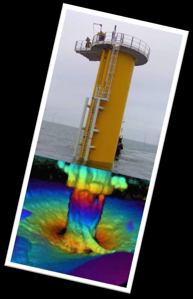
9 Real-Time 3D Sonar Technology Subsea environment is Cluttered and Complex Without additional multi-sampling visual sensors how can we be sure of complete coverage in the environment? Angle of incidence is critical for sonar returns! Echoscope has 128 angular multibeam slices in every ping Ability to ensonify the same target from multiple different angles many times a second Complete statistical analysis capability for improved probability of target & object verification and identification (sub-beam object detection) Ability to instantly switch from MAPPING to MONITORING in a single deployment providing real-time support for divers and ROV Real-Time Data = Real-Time Decision Making
10 Real-Time 3D Sonar Technology Why is Real-Time 3D important for Subsea Visualization? Subsea operations are often in zero visibility Operator on surface needs to see, place or remove asset Speed and accuracy of operation is critical to remain efficient and cost effective Real-Time data for accurate decision making is vital to avoid re-work Safety concerns mainly for personnel, but also subsea asset Meets the priority and focus of Industry Key Players (example Chevron) Improve Sensor Capability? More Efficient Collection of Data? Better Representation of Data?


11 Non-Vessel Platforms
12 Application Segments Static or moving applications for LIVE camera replacement and 3D real-time visualization Hydrographic survey, seabed and infrastructure mapping of complex targets Complex structure TRUE 3D measurement with model augmentation

13 MONITOR Applications Construction & Decommissioning, Diver Support, ROV / AUV Support, Gas and Leak Detection.

14 MONITOR Applications Construction & Decommissioning, Diver Support, ROV / AUV Support, Gas and Leak Detection.

15 MONITOR Applications Construction & Decommissioning, Diver Support, ROV / AUV Support, Gas and Leak Detection.

16 MONITOR Applications Construction & Decommissioning, Diver Support, ROV / AUV Support, Gas and Leak Detection.

17 MAP Applications Survey, Pipeline Inspection, Decommissioning, Rig Inspection, Salvage, Construction, Comparison.


18 MEASURE Applications 3D Modeling, Change & Baseline-Comparison, Navigation and OA, Scene Awareness.


19 Subsea Data Management Data Sharing and 3 rd Party Integration Data can be easily exported and integrated with standard 3rd Party Systems Full XYZi Export Binned or RAW (any point cloud application) Direct interfaces with QPS QINSy and Hypack Real-Time Data = Real-Time Decision Making


20 TCO & ROI Benefits What are the key benefits from Real-Time 3D? TIME & COST SAVING Reduced survey time = significant cost reduction No or Minimal Post-Processing Required Immediate data visualization to avoid re-work Single sensor for both Moving and Static Applications QUALITY HUGE data redundancy for improved accuracy High definition imagery and bathymetry from a single sensor Image fidelity = Intuitive = High user confidence We SEE more than any other sensor minimal shadows!


21 Case Study Subsea environment is Cluttered and Complex Lockheed Martin MARLIN Intelligent Autonomous Vehicle Primary Sensor is Echoscope Real-Time 3D Sonar Mission profile reduced from days to minutes Echoscope Data Density and Coverage enables Real-Time Change Detection and adaptive mission planning Survey to processing and model < 1hour in the clients hands!! Real-Time Data = Real-Time Decision Making
22 Thank You!...Questions? Chief Technology Officer CodaOctopus Products, Ltd. Booth A33a
1 Introduction integrated 3D sonar system for underwater inspection applications
 1 Introduction The Underwater Inspection System (UIS TM ) is an integrated 3D sonar system for underwater inspection applications, specifically port and harbor construction, maintenance, port expansion,
Survey Sensors. 18/04/2018 Danny Wake Group Surveyor i-tech Services
 Survey Sensors 18/04/2018 Danny Wake Group Surveyor i-tech Services What do we need sensors for? For pure hydrographic surveying: Depth measurements Hazard identification Seabed composition Tides & currents
Tritech International Vehicle Sonar Developments
 Tritech International Vehicle Sonar Developments Mike Broadbent Business Development Manager Oceanology 2012 - UUVS Overview About Tritech Mechanical Scanning Sonar - Improving the performance High Speed
Surveyors in The Oil & Gas Industry. Walter Jardine Lead Surveyor, BP North Sea Region Hydrofest 13 April 2011
 Surveyors in The Oil & Gas Industry what on earth do those guys do? Walter Jardine Lead Surveyor, BP North Sea Region Hydrofest 13 April 2011 Why Geography Matters in the O&G Industry Around 80% of the
Teledyne Marine Acoustic Imagining
 RESON SeaBat high performance sonars for long range object detection and MCM applications Navigation, object avoidance & up close inspection with BlueView Greg Probst Sales Manager, Defense Teledyne Marine
OFFSHORE ANALYSIS & RESEARCH SOLUTIONS HOUSTON PETROLEUM SURVEYORS GROUP PERSONNEL DATA PROCESSING PARTNERSHIPS
 OFFSHORE ANALYSIS & RESEARCH SOLUTIONS HOUSTON PETROLEUM SURVEYORS GROUP KEEPING YOUR PROJECTS IN MOTION OARS-HPSG combines the experience of two highly complementary organizations providing expanded capabilities,
Subsea UK 2014 Developments in ROV Technology
 Subsea UK 2014 Developments in ROV Technology Smarter Technologies Enable Smarter Platforms (ROVs) => Improved Offshore Operations Nick Lawson What does an ROV do? Any ROVs primary function is to provide
Robots at Work The growing role of robotic systems in the Oceans and Subsea Engineering. David Brookes Senior Advisor, Upstream Engineering, BP
 Robots at Work The growing role of robotic systems in the Oceans and Subsea Engineering David Brookes Senior Advisor, Upstream Engineering, BP Synopsis ROV s History Current Capabilities and Examples AUV
Pipeline Inspection and Environmental Monitoring Using AUVs
 Pipeline Inspection and Environmental Monitoring Using AUVs Bjørn Jalving, Bjørn Gjelstad, Kongsberg Maritime AUV Workshop, IRIS Biomiljø, 7 8 September 2011 WORLD CLASS through people, technology and
Introduction OTC MS
 OTC-24224-MS A new approach to Pipeline Inspection using Autonomous Underwater Vehicles (AUV s). Amin Nasr, Anne Courbot, TOTAL SA Bill Gilmour, Caitlin Biedermann, Chevron ETC Copyright 2013, Offshore
UDW Technology Conference Dan McLeod / John Jacobson Lockheed Martin MS2 July 27, Secure Energy for America
 RPSEA 09121-3300 3300-05 05 Autonomous Inspection of Subsea Facilities Phase I Final Presentation / Phase II Status Report UDW Technology Conference Dan McLeod / John Jacobson Lockheed Martin MS2 July
The Oil & Gas Industry Requirements for Marine Robots of the 21st century
 The Oil & Gas Industry Requirements for Marine Robots of the 21st century www.eninorge.no Laura Gallimberti 20.06.2014 1 Outline Introduction: fast technology growth Overview underwater vehicles development
Autonomous Inspection of Subsea Facilities
 Autonomous Inspection of Subsea Facilities RPSEA 09121 3300 05 Final Presentation RPSEA Ultra Deepwater Subsea Systems TAC Meeting January 24, 2012 GFBEDC Boardroom Sugar Land, TX John Jacobson, Lockheed
Three-dimensional investigation of buried structures with multi-transducer parametric sub-bottom profiler as part of hydrographical applications
 Three-dimensional investigation of buried structures with multi-transducer parametric sub-bottom profiler as part Jens LOWAG, Germany, Dr. Jens WUNDERLICH, Germany, Peter HUEMBS, Germany Key words: parametric,
Seafloor Mapping Using Interferometric Sonars: Advances in Technology and Techniques
 Seafloor Mapping Using Interferometric Sonars: Advances in Technology and Techniques Tom Hiller, Advanced Products Manager, GeoAcoustics Ltd. WORLD CLASS through people, technology and dedication Brest,
Autonomous Underwater Vehicles
 Autonomous Underwater Vehicles A View of the Autonomous Underwater Vehicle Market For a number of years now the Autonomous Underwater Vehicle (AUV) has been the undisputed tool of choice for certain niche
SWiG Subsea Wireless Group - Presentation to API
 Commercial in Confidence SWiG Subsea Wireless Group - Presentation to API January 14 Commercial in Confidence Agenda About SWiG What is the technology? Where is it used? SWiG family of standards Where
Subsea Monitoring & Mapping
 Subsea Monitoring & Mapping Arnold Hechanova & Dave Fraser ITAC Meeting 2016 Woods Hole Oceanographic Institute, MA Overview Program Objective: Develop sensors to detect loss of containment subsea and
Engineering measurements from subsea laser scanning Data gathering and analysis. Presented by Brett Lestrange, Regional Director Europe
 Engineering measurements from subsea laser scanning Data gathering and analysis Presented by Brett Lestrange, Regional Director Europe Introduction There is a growing number of aging subsea assets in use
Survey Operations Pipeline Inspection
 Survey Operations Pipeline Inspection HydroFest 16 th April 20 Kevin Donald Agenda Why Inspect? Definition of a Pipeline Types of Survey Positioning Data Processing The Future Conclusions Page 2 Why Inspect?
Automation at Depth: Ocean Infinity and seabed mapping using multiple AUVs
 Automation at Depth: Ocean Infinity and seabed mapping using multiple AUVs Ocean Infinity s seabed mapping campaign commenced in the summer of 2017. The Ocean Infinity team is made up of individuals from
Handling Interferometric Data: Streamlining the Processing Flow
 Handling Interferometric Data: Streamlining the Processing Flow Paper 5 at Hydro8, 4 th November 2008 Tom Hiller, Advanced Products Manager, GeoAcoustics Ltd. WORLD CLASS through people, technology and
Teledyne Marine Oil and Gas.
 Oil and Gas www.teledynemarine.com/energy Applications in Oil and Gas Teledyne Marine encompasses over 20 brands that offer innovative, highly reliable technology spanning the life cycle of an oil field,
Subsea Positioning In deep water
 Subsea Positioning In deep water PETRONAS - PETRAD - INTSOK CCOP DEEPWATER SUBSEA TIE-BACK Damai Puri Resort & Spa, Kuching, Sarawak, MALAYSIA 24TH - 26TH January, 2011 Supplier to the oil & gas industry
Emerging Subsea Networks
 FIBRE-TO-PLATFORM CONNECTIVITY, WORKING IN THE 500m ZONE Andrew Lloyd (Global Marine Systems Limited) Email: andrew.lloyd@globalmarinesystems.com Global Marine Systems Ltd, New Saxon House, 1 Winsford
SUT, Aberdeen November Exeter London Glasgow Houston Calgary
 SUT, Aberdeen November 2018 Exeter London Glasgow Houston Calgary Mission - The Digital Age Delivering increased safety and visibility of assets, processes and infrastructure whilst reducing cost/ risk
Using Norwegian competence from oil and gas subsea operations towards the development of ocean mining operations
 Using Norwegian competence from oil and gas subsea operations towards the development of ocean mining operations Yoshinori Miura, Jens Laugesen, Øyvind Fjukmoen, Lucy Brooks, Karsten Hagenah, Tor Jensen
Experiences with Hydrographic Data Budgets Using a Low-logistics AUV Platform. Thomas Hiller Teledyne Marine Systems
 Experiences with Hydrographic Data Budgets Using a Low-logistics AUV Platform Thomas Hiller Teledyne Marine Systems 1 Teledyne Marine Systems Strategic Business Units 2 What is the Gavia? The Gavia is
Synthesis of acoustic images of underwater targets
 FACULDADE DE ENGENHARIA DA UNIVERSIDADE DO PORTO Synthesis of acoustic images of underwater targets Duarte Nuno Reimão Borges Lopes Silva PREPARATION FOR THE MSC DISSERTATION Master in Electrical and Computers
Pioneers of Wideband High Resolution Multibeam Systems
 Pioneers of Wideband High Resolution Multibeam Systems W W W. R 2 S O N I C. C O M Systems Overview The R2Sonic Sonic Series are the world s first true wideband high resolution Motion Heading SV GPS shallow
Company Profile. Facilities
 Company Profile R2Sonic was founded in February 2006 by three veteran underwater acoustical engineers; Jens R. Steenstrup, Mark Chun and Kirk Hobart; with the mission to utilize their experience to bring
Responsive AUV Localization and Mapping Project. Ron Lewis, Project Manager June 14 th, 2012
 Responsive AUV Localization and Mapping Project Ron Lewis, Project Manager June 14 th, 2012 Project Overview Project duration: Approximately 5 Years June 1, 2010 to March 31, 2015 Primary objectives: Develop
SYSTEM 5900 SIDE SCAN SONAR
 SYSTEM 5900 SIDE SCAN SONAR HIGH-RESOLUTION, DYNAMICALLY FOCUSED, MULTI-BEAM SIDE SCAN SONAR Klein Marine System s 5900 sonar is the flagship in our exclusive family of multi-beam technology-based side
USBL positioning and communication SyStEmS. product information GUidE
 USBL positioning and communication SyStEmS product information GUidE evologics s2c R usbl - series underwater positioning and communication systems EvoLogics S2CR USBL is a series of combined positioning
Mid-Frequency Reverberation Measurements with Full Companion Environmental Support
 DISTRIBUTION STATEMENT A. Approved for public release; distribution is unlimited. Mid-Frequency Reverberation Measurements with Full Companion Environmental Support Dajun (DJ) Tang Applied Physics Laboratory,
ROVO 2201 (ROV Operations)
") ROVO 2201 (ROV Operations) TYPE AND PUR POSE: This course is designed to instruct students in the proficient and safe operation of underwater robotic systems throughout their full range of subsea applications.
ROVO 2201 (ROV Operations) TYPE AND PUR POSE: This course is designed to instruct students in the proficient and safe operation of underwater robotic systems throughout their full range of subsea applications.
Hydrographic processing considerations in the Big Data age: An overview of technology trends in ocean and coastal surveys
 IOP Conference Series: Earth and Environmental Science PAPER OPEN ACCESS Hydrographic processing considerations in the Big Data age: An overview of technology trends in ocean and coastal surveys To cite
ISTAR Concepts & Solutions
 ISTAR Concepts & Solutions CDE Call Presentation Cardiff, 8 th September 2011 Today s Brief Introduction to the programme The opportunities ISTAR challenges The context Requirements for Novel Integrated
Subsea UK Neil Gordon Chief Executive Officer Championing the UK Subsea Sector Across the World
 Subsea UK Neil Gordon Chief Executive Officer Championing the UK Subsea Sector Across the World 1 Overview About Subsea UK Facts and figures UK industry evolution Centre of Excellence Technology and Innovation
Multibeam Echosounder Metadata and Quality Statistics
 Multibeam Echosounder Metadata and Quality Statistics Dave Mann, Survey Support Manager, Gardline Geosurvey Gardline MBES Systems Sea Explorer EM1002 RV Triton EM1002(S) Ocean Seeker EM1002(S) Ocean Endeavour
A 3D, FORWARD-LOOKING, PHASED ARRAY, OBSTACLE AVOIDANCE SONAR FOR AUTONOMOUS UNDERWATER VEHICLES
 A 3D, FORWARD-LOOKING, PHASED ARRAY, OBSTACLE AVOIDANCE SONAR FOR AUTONOMOUS UNDERWATER VEHICLES Matthew J. Zimmerman Vice President of Engineering FarSounder, Inc. 95 Hathaway Center, Providence, RI 02907
MARISSUBSEA.com. Core Values. People. Integrity. Quality. Contents. 02/03 What we do. 04/05 Representatives. 06/07 ROV personnel
 MARISSUBSEA.com Contents 02/03 What we do 04/05 Representatives 06/07 ROV personnel 08/09 Hydrographic personnel 10/11 Diving personnel 12/13 Additional disciplines Core Values People Our people make our
KONGSBERG seafloor-mapping echosounders
 KONGSBERG seafloor-mapping echosounders Berit Horvei WORLD CLASS through people, technology and dedication AGENDA Historical overview EM series Multibeam echosounder and Subbottom profiler Topside software.
Using synthetic aperture sonar as an effective hydrographic survey tool
 Using synthetic aperture sonar as an effective hydrographic survey tool Andy Hoggarth 1 (presenter), Karl Kenny 2 1. CARIS 1, 115 Waggoners Lane, Fredericton, NB CANADA E3B 2L4, 506-458-8533 2. Kraken
Marine Construction Support & Dimensional Control
 Page 1 of 5 Marine Construction Support & Dimensional Control Key Specifications Surface and Subsurface Positioning IRM Support Lay Support Trench Suport Installation Support Metrology As-Built Heavy Lift
WORLD CLASS through people, technology and dedication
 WORLD CLASS through people, technology and dedication WORLD CLASS through people, technology and dedication 1 2 Acoustic Positioning Systems Hydrofest Robert Gordon University Scott Sutherland Building
WORLD CLASS through people, technology and dedication WORLD CLASS through people, technology and dedication
 WORLD CLASS through people, technology and dedication WORLD CLASS through people, technology and dedication 1 2 Acoustic Positioning Systems Hydrofest Aberdeen University Wednesday 31 st March Ian Florence
Dimensional Survey Company
 Dimensional Survey Company Services Anko Bluepix was founded in 2016 by experienced engineers, each a specialist within different segments of the survey business. Even though Anko Bluepix is a young company
USBL positioning and communication systems. Applications
 USBL positioning and communication systems Offering a powerful USBL transceiver functionality with full benefits of an S2C technology communication link Applications Positioning of offshore equipment >
Deep. Navigating the. High Accuracy Positioning Support for Deep Water Construction. Copyright Journal of Ocean Technology 2017
 Navigating the Deep High Accuracy Positioning Support for Deep Water Construction by Will Primavesi, Tamir Frydenrych, and Drew Nicholson ISTOCKPHOTO.COM/CHERT61 The Journal of Ocean Technology, Vol. 12,
LBL POSITIONING AND COMMUNICATION SYSTEMS PRODUCT INFORMATION GUIDE
 LBL POSITIONING AND COMMUNICATION SYSTEMS PRODUCT INFORMATION GUIDE EvoLogics S2C LBL Underwater Positioning and Communication Systems EvoLogics LBL systems bring the benefi ts of long baseline (LBL) acoustic
GeoSwath Plus Wide swath bathymetry and georeferenced side scan
 GeoSwath Plus Wide swath bathymetry and georeferenced side scan www.geoacoustics.com GeoSwath Plus Wide Swath Bathymetry and co-registered georeferenced side scan system We maximise marine performance
Dimensional Survey Company
 Dimensional Survey Company AnkoBluepix was founded in 2016 by experienced engineers, each a specialist within different segments of the survey business. Even though AnkoBluepix is a young company Our Mother
SUB-SEABED MAPPING USING AUV-BASED MULTI-STATIC ACOUSTIC SENSING AND ADAPTIVE CONTROL
 SUB-SEABED MAPPING USING AUV-BASED MULTI-STATIC ACOUSTIC SENSING AND ADAPTIVE CONTROL H. SCHMIDT, J. LEONARD, J.R. EDWARDS AND T-C. LIU Massachusetts Institute of Technology, 77 Massachusetts Avenue, Cambridge
INTEGRATED SERVICES AND PRODUCTS ACROSS THE FIELD LIFE CYCLE
 INTEGRATED SERVICES AND PRODUCTS ACROSS THE FIELD LIFE CYCLE 4 What we do 6 Why choose us? 7 Service and product capabilities For more than 35 years, we have been providing clients with standalone and
Wave & Tidal Safety & Construction Guidelines
 Wave & Tidal Safety & Construction Guidelines Malcolm Bowie Ltd All-Energy, Aberdeen, 24 th May 2012 Principal Challenges - Energetic environment with very unique construction risks. - Many new / radical
Multibeam data quality assurance at Genavir. Karine Abel Michaux
 Multibeam data quality assurance at Genavir Hervé Bisquay hbisquay@genavir.fr Karine Abel Michaux kabelmic@genavir.fr Pascal Viollette pviollette@genavir.fr GENAVIR Genavir is the operator of the civilian
Single Source For Subsea Solutions
 Single Source For Subsea Solutions SAFETY FocuS C-Innovation prides itself on maintaining the highest possible standards of health, safety and environmental sensitivity. In each QHSE area, we strive to
MINE SEARCH MISSION PLANNING FOR HIGH DEFINITION SONAR SYSTEM - SELECTION OF SPACE IMAGING EQUIPMENT FOR A SMALL AUV DOROTA ŁUKASZEWICZ, LECH ROWIŃSKI
 MINE SEARCH MISSION PLANNING FOR HIGH DEFINITION SONAR SYSTEM - SELECTION OF SPACE IMAGING EQUIPMENT FOR A SMALL AUV DOROTA ŁUKASZEWICZ, LECH ROWIŃSKI Gdansk University of Technology Faculty of Ocean Engineering
Underwater Vehicles Conference
 Underwater Vehicles Conference Aberdeen Exhibition and Conference Centre, Aberdeen 27 th September 2016 Image Courtesy of STL SPONSORED BY SUPPORTED BY 09:00 Registration and Welcome Market and Industry
Teledyne Oil & Gas Innovation and Subsea Reliability
 A Member of Innovation and Subsea Reliability www.teledyneoilandgas.com Technologies A Member of Seismic Instruments Imaging Vehicles Photo Courtesy BMT has been proudly serving the oil and gas industry
Robotics in Oil and Gas. Matt Ondler President / CEO
 Robotics in Oil and Gas Matt Ondler President / CEO 1 Agenda Quick background on HMI State of robotics Sampling of robotics projects in O&G Example of a transformative robotic application Future of robotics
MARKSMAN DP-INS DYNAMIC POSITIONING INERTIAL REFERENCE SYSTEM
 cc MARKSMAN DP-INS DYNAMIC POSITIONING INERTIAL REFERENCE SYSTEM Sonardyne s Marksman DP-INS is an advanced navigation-based Position Measuring Equipment (PME) source for dynamically positioned (DP) rigs.
SONOBOT AUTONOMOUS HYDROGRAPHIC SURVEY VEHICLE PRODUCT INFORMATION GUIDE
 SONOBOT AUTONOMOUS HYDROGRAPHIC SURVEY VEHICLE PRODUCT INFORMATION GUIDE EvoLogics Sonobot an autonomous unmanned surface vehicle for hydrographic surveys High Precision Differential GPS for high-accuracy
Eelume: A Resident Subsea IMR Vehicle. Peter Bennett Business Manager Subsea Kongsberg Maritime
 Eelume: A Resident Subsea IMR Vehicle Peter Bennett Business Manager Subsea Kongsberg Maritime Introducing Eelume Page 2 Page 3 Eelume: the Set Up LOOP Agreement Demanding customer Experience, Marketing
Positioning Small AUVs for Deeper Water Surveys Using Inverted USBL
 Positioning Small AUVs for Deeper Water Surveys Using Inverted USBL Presented at Hydro12, Rotterdam, November 2012 Dr. T.M. Hiller, thiller@teledyne.com Overview Introduction to Gavia AUV Gavia Acoustic
i-tech SERVICES DELIVERING INTEGRATED SERVICES AND PRODUCTS ACROSS THE FIELD LIFE CYCLE
 i-tech SERVICES DELIVERING INTEGRATED SERVICES AND PRODUCTS ACROSS THE FIELD LIFE CYCLE 3 About us 4 What we do 6 Why choose us? 7 Service and product capabilities OUR VALUES Safety Integrity Innovation
Ongoing Developments in Side Scan Sonar The pursuit of better Range, Resolution and Speed
 Ongoing Developments in Side Scan Sonar The pursuit of better Range, Resolution and Speed Nick Lawrence EdgeTech Advances in Seafloor-mapping Sonar Conference 30 th November 2009 Company Profile EdgeTech
Multi-Beam Echo Sounders do beam width, frequency, number of beams matter? James Williams Managing Director
 Multi-Beam Echo Sounders do beam width, frequency, number of beams matter? James Williams Managing Director 1 Swathe Services We offer Product Sales, Equipment Rental and Personnel Deployment Our latest
Ranger USBL Acoustic Positioning System for DP Reference and Survey
 Acoustic Positioning System for DP Reference and Survey cc 545000m N 544990m 544980m 544970m 6027910m 6027900m W 6027890m 6027880m S Contents Introduction 01 Ranger USBL System Overview 02 Ranger USBL
Object Detection with Phase-Measuring Bathymetric Sidescan Sonar Depth Data
 Object Detection with Phase-Measuring Bathymetric Sidescan Sonar Depth Data Kevin Jerram and Val Schmidt Center for Coastal and Ocean Mapping Durham, New Hampshire A shipwreck and bedforms are visible
Defense and Maritime Solutions
 Defense and Maritime Solutions Automatic Contact Detection in Side-Scan Sonar Data Rebecca T. Quintal Data Processing Center Manager John Shannon Byrne Software Manager Deborah M. Smith Lead Hydrographer
Gyrocompass and motion sensor. octans. navigation and positioning
 Gyrocompass and motion sensor octans navigation and positioning the best in fog technology The technological heart of is the Fibre-Optic Gyroscope (FOG), the only truly-solid-state answer to rotation sensing.
ACTEON FLS - DECOMMISSIONING
 ACTEON FLS - DECOMMISSIONING CLIENT VERSION 15 FEBRUARY 2016 INTRODUCTION TO ACTEON FLS ACTEON FLS Subsea services company Acteon has launched a new service. Acteon Field Life Service (FLS) offers a joined-up
Eelume: The Next Evolution in Underwater Robotics. Richard Mills Director of Sales Marine Robotics Kongsberg Maritime AS
 Eelume: The Next Evolution in Underwater Robotics Richard Mills Director of Sales Marine Robotics Kongsberg Maritime AS A brief history of Marine Robotics First controlled underwater vehicle developed
Quick start guide M3 Sonar
 Quick start guide M3 Sonar Creating an image mosaic using Photoshop and Geographic Imager 2013, Kongsberg Mesotech Ltd. 922-20007005 M3 Sonar Quick start guide Creating an image mosaic using Photoshop
Cathodic Protection & Monitoring
 Cathodic Protection & Monitoring THE COMPLETE SOLUTION MEASUREMENT COMMUNICATION INSIGHT Contents Cathodic Protection Services 2 Consultancy 3 Systems 5 Monitoring 8 Insight 10 1 Aquatec was founded by
Object Detection for Underwater Port Security
 Object Detection for Underwater Port Security Dr. Lloyd Huff LCHUFF CONSULTANCY,LLC Mr. John Thomas TRITON IMAGING,INC Shallow Survey 2012 February 22, 2012 INTRODUCTION I am glad to be here today to make
Remote Sensing of Deepwater Shipwrecks
 Abigail Casavant December 16, 2014 Final Project NRS 509 Remote Sensing of Deepwater Shipwrecks Underwater archaeology is still a relatively new field in terms of age and technological advances. With the
Applications. > > Oil & Gas. > > RoVs and auvs. > > Oceanography. > > Monitoring stations. > > Seismic. > > Networks and relay chains
 Underwater acoustic Modems EvoLogics S2CR - series underwater acoustic modems provide full-duplex digital communication delivering an excellent performance, resistant to the challenges of the dynamic subsea
global acoustic positioning system GAPS usbl acoustic with integrated INS positioning system Ixsea Oceano GAPS page 1
 global acoustic positioning system usbl acoustic positioning system with integrated INS positioning system page 1 THE MERGER OF INERTIAL AND UNDERWATER ACOUSTIC TECHNOLOGIES is a unique Global Acoustic
Physics-based Simulation Environment for Adaptive and Collaborative Marine Sensing with MOOS-IvP
 Physics-based Simulation Environment for Adaptive and Collaborative Marine Sensing with MOOS-IvP Prof. Henrik Schmidt Laboratory for Autonomous Marine Sensing Systems Massachusetts Institute of technology
High Resolution Optical Imaging for Deep Water Archaeology
 High Resolution Optical Imaging for Deep Water Archaeology Hanumant Singh 1, Christopher Roman 1, Oscar Pizarro 2, Brendan Foley 1, Ryan Eustice 1, Ali Can 3 1 Dept of Applied Ocean Physics and Engineering,
Kongsberg Maritime Product overview
 Kongsberg Maritime Product overview / 1 / 1-Nov-12 Frequency Range Coverage 125,250,500kHz 0.5-200m 12xD 200-400kHz 0.5-500m 5.5xD / 140-200 deg 300 khz 0.5-270m 4-10xD / 130-200 deg 70-100 khz 3-2000m
More with Less ROV Solutions to Offshore Challenges
 More with Less ROV Solutions to Offshore Challenges Content Introduction Operational Challenges Global Involvement with government and military agencies VALOR Versatile and Lightweight Observation ROV
Author s Name Name of the Paper Session. DYNAMIC POSITIONING CONFERENCE October 10-11, 2017 SENSORS SESSION. Sensing Autonomy.
 Author s Name Name of the Paper Session DYNAMIC POSITIONING CONFERENCE October 10-11, 2017 SENSORS SESSION Sensing Autonomy By Arne Rinnan Kongsberg Seatex AS Abstract A certain level of autonomy is already
Semi-buried seabed object detection: Sonar vs. Geophysical methods
 Semi-buried seabed object detection: Sonar vs. Geophysical methods Dino DRAGUN, Croatia, Lieselot NOPPE, Belgium, Pierre SERPE, Belgium, Emeline CARON, France, Astrid ROBERT, France Key words: Site Investigation,
Effective and cost saving CP survey by use of FiGS technology FORCE Technology Norway
 Effective and cost saving CP survey by use of FiGS technology FORCE Technology Norway LEIV ERLING GRYTTEN SALES MANAGER FiGS can be used for all types of FiGS CP survey application areas subsea structures
OPT Commercialization Update
 OPT Commercialization Update Forward Looking Statements In addition to historical information, this presentation contains forward-looking statements that are within the safe harbor provisions of the Private
SONOBOT AUTONOMOUS HYDROGRAPHIC SURVEY VEHICLE PRODUCT INFORMATION GUIDE
 SONOBOT AUTONOMOUS HYDROGRAPHIC SURVEY VEHICLE PRODUCT INFORMATION GUIDE EvoLogics SONOBOT: Autonomous Surface Vehicle for Hydrographic Surveys High Precision Differential GPS for high-accuracy cartography
DOWNLOAD OR READ : ADVANCES IN UNDERWATER TECHNOLOGY OCEAN SCIENCE AND OFFSHORE ENGINEERING OFFSHORE SITE INVESTIGATIO PDF EBOOK EPUB MOBI
 DOWNLOAD OR READ : ADVANCES IN UNDERWATER TECHNOLOGY OCEAN SCIENCE AND OFFSHORE ENGINEERING OFFSHORE SITE INVESTIGATIO PDF EBOOK EPUB MOBI Page 1 Page 2 investigatio advances in underwater technology pdf
Che Keong Lee Sales Subsea Manager Kongsberg Maritime AS. Eelume: A Resident Subsea IMR Vehicle
 Che Keong Lee Sales Subsea Manager Kongsberg Maritime AS Eelume: A Resident Subsea IMR Vehicle Introducing Eelume Page 2 Page 3 Eelume: the Set Up LOOP Agreement Demanding customer Experience, Marketing
STE Standards and Architecture Framework TCM ITE
 STE Framework TCM ITE 18 Sep 17 Further dissemination only as directed by TCM ITE, 410 Kearney Ave., Fort Leavenworth, KS 66027 or higher authority. This dissemination was made on 8 SEP 17. 1 Open Standards
Seatooth Pipelogger. Ian Crowther Executive VP WFS Technologies
 Ian Crowther Executive VP WFS Technologies About WFS Technologies WFS Wireless For Subsea Founded 2003 Operations in UK & USA Wireless Solutions Drilling Subsea Vehicles Asset Integrity Management Field
Fugro Worldwide Fugro Environmental
 1 2 Fugro Worldwide The Fugro group of companies is an international consulting company that provides measurements and interpretations of data related to the earth's surface and the soils and rocks beneath.
Burial Depth Determination of Cables Using Acoustics Requirements, Issues and Strategies
 Burial Depth Determination of Cables Using Acoustics Requirements, Issues and Strategies Jens WUNDERLICH 1, Jan Arvid INGULFSEN 2, Sabine MÜLLER 1 Cable + Survey Requirements Cable Acoustics Survey Strategies
Nomarna Construcciones e Ingeniería develops a high knowledge in solutions of design, consulting, training, supervision, manufacturing and management
 Nomarna Construcciones e Ingeniería develops a high knowledge in solutions of design, consulting, training, supervision, manufacturing and management of engineering and construction design for the Oil
Autonomous Underwater Vehicles
 Autonomous Underwater Vehicles New Autonomous Underwater Vehicle technology development at WHOI to support the growing needs of scientific, commercial and military undersea search and survey operations
GEO-MARINE TECHNOLOGY, INC. A Geological, Geophysical, and Hydrographic Survey Consultancy
 COMPANY PROFILE OUR MISSION AND TRADE OUR MISSION: OUR TRADE: We few, professional scientists strive to support the objectives of our marine energy and telecommunications clients with cooperation, innovation
Adapting the advances in survey technology and visualization to provide new and better products
 Adapting the advances in survey technology and visualization to provide new and better products Duncan Mallace 1, John Dillon-Leetch 2, Lindsay Gee, Maurice Doucet 3, Rob Spillard, Alison Kentuck 4 and