ELEVENTH INTERNATIONAL FLIGHT INSPECTION SYMPOSIUM GPS WORKSHOP PROGRAM A G E N D A
|
|
|
- Rudolf Stevenson
- 5 years ago
- Views:
Transcription

1
2
3 ELEVENTH INTERNATIONAL FLIGHT INSPECTION SYMPOSIUM GPS WORKSHOP PROGRAM A G E N D A SANTIAGO CROWNE PLAZA HOTEL SALON CONSTITUCION JUNE 05, SANTIAGO, CHILE 08:00-08:45 Registration 08:45-09:00 Introduction 09:00-09:35 GNSS Basics MONDAY, JUNE 05 09:35-10:10 Augmentation (SBAS/GBAS) 10:10-10:40 Break 10:40-11:15 GNSS Augmentation - Basic Suitability/Limits for Aviation 11:15-11:50 WGS-84 and its application to GNSS 11:50-13:00 GNSS - Real and proposed Systems 13:00-14:00 Lunch GNSS - GPS and NAS Implementation GNSS - Galileo 14:00-15:45 SBAS Augmentation Systems 15:45-16:20 Break SBAS - WAAS SBAS - EGNOS SBAS - MTSAT 16:20-16:55 GBAS Augmentation systems GBAS Standardized system (ICAO) 16:55-17:30 Future enhancements
4 ELEVENTH INTERNATIONAL FLIGHT INSPECTION SYMPOSIUM MONDAY, JUNE 05 GPS WORKSHOP PROGRAM A G E N D A SANTIAGO CROWNE PLAZA HOTEL JUNE 05, SANTIAGO, CHILE 1.- GNSS Basics Speaker: Prof. DAVE POWELL - Stanford University 2.- Augmentation (SBAS/GBAS) Speaker: Dr. TODD WALTER - Stanford University 3.- GNSS and Augmentation - Basic Suitability/Limits for Aviation Speaker: Mr. DAN HANLON - FAA 4.- WGS-84 and its application to GNSS Speaker: Mr. MICHAEL MORGAN - NIMA 5.- GNSS - Real and Proposed Systems GNSS - GPS and NAS Implementation Speaker: Mr. JIMMY R. SNOW - FAA AVN GPS Program GNSS - Galileo Speaker: Mr. STEFAN NAERLICH - DFS Deutsche Flugsicherung GmbH 6.- SBAS Augmentation Systems SBAS - WAAS Speaker: Mr. JOHN BRITIGAN - Raytheon WAAS Leader). SBAS - EGNOS Speaker: Mr. STEFAN NAERLICH - DFS Deutsche Flugsicherung GmbH SBAS - MTSAT Speaker: Dr. ROBERT LOH - Innovative Solutions International Mr. NAOTO ASADA - Japanese Flight Inspection Unit 7.- GBAS Augmentation Systems GBAS Standardized system (ICAO) Speaker: Ms. MARIA DIPASQUANTONIO - FAA LAAS IPT Lead 8.- Future Enhancements Speaker: Mr. CURT KEEDY - Flight Inspection Policy and Standards -FAA
5 GPS WORKSHOP Brief description of Topics 1.- GNSS Basic Satellite constellation, how CDMA ranging works, position calculation, concept of DOP, control segment. and any other relevant information related to GNSS. 2.- Augmentation (SBAS/GBAS) Description of error sources, difference in correction quality, effect of time and distance. Report on the experiments that have been performed and the accuracy obtained from the test bed that has been operating up to day. 3.- GNSS and augmentation - Basic Suitability/Limits for aviation Updates to GPS and future plans. Status and future of WAAS. What are the present capabilities and what the aviation community expects in the next 20 years for WAAS. Limitations if any, and its potential solution. 4.- WGS-84 and its application to GNSS The presentation describes the generation of data sets, which are based on a single geodetic system (WGS-84). 5.- GNSS - Real and proposed Systems GNSS - GPS GNSS - Galileo Description of the improvements to GPS that can be made by onboard equipment. What GPS implementation is and and what its capabilities are. Updates for GLONASS and its future advancements. Current status of the GNSS possibilities worldwide, including a description of the proposed system, if available 6.- SBAS Augmentation Systems WAAS EGNOS MTSAT Description of each SBAS being designed and built in the different regions of the world. What the aviation community could expect in the immediate and middle future. 7.- GBAS Augmentation Systems GBAS standardized system (ICAO) Description of the various local differential systems being designed and built. Status and future of LAAS. What are the present capabilities and what the community expect in the next 20 years for LAAS. 8.- Future GPS enhancements Description of the new civil frequencies and their effect on interference robustness and ability to carry out carrier tracking. Future of GPS.
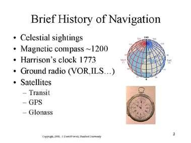
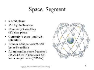
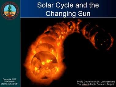
6 GNSS Basics Prof. DAVE POWELL Stanford University

7


8

9


10
11
12
13

14

15

16


17
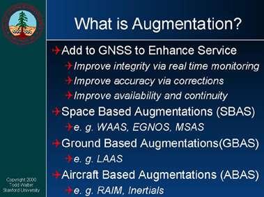
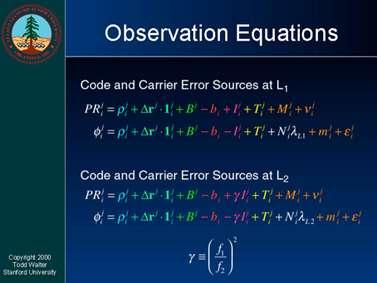
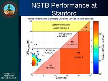
18 Augmentation (SBAS/GBAS) Dr. TODD WALTER Stanford University

19


20


21


22


23


24

25


26

27


28

29


30

31


32


33


34


35
36
37 GNSS and Augmentation Basic Suitability/Limits for Aviation Mr. DAN HANLON FAA
38

39


40

41


42


43


44


45


46

47
48 WGS-84 and its application to GNSS Mr. MICHAEL MORGAN NIMA

49

50
51


52

53
54


55

56

57
58

59
60
61

62
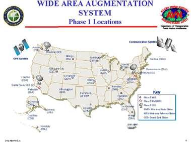
63 GNSS - Real and Proposed Systems GNSS - GPS and NAS Implementation Mr. JIMMY R. SNOW FAA AVN GPS Program


64


65


66

67


68

69


70


71


72


73

74


75


76


77


78
79
80 GNSS - Real and Proposed Systems GNSS - Galileo Mr. STEFAN NAERLICH DFS Deutsche Flugsicherung GmbH
81 Stefan Naerlich DFS Deutsche Flugsicherung GmbH Kaiserleistrasse Offenbach Germany THE DEFINITION PHASE OF THE GALILEO GLOBAL NAVIGATION SATELLITE SYSTEM March 23rd, 2000 ABSTRACT The Definition Phase of the Galileo Global Navigation Satellite System In June 1999, the Council of the Transport Ministers of the European Union decided to enter into the Definition Phase for a European Global Navigation Satellite System "Galileo". Galileo, as a joint programme of the European Commission and ESA, will be composed of a global constellation of MEO (Medium Earth Orbit) satellites complemented with regional (i.e. geostationary satellites) and local segments. Two types of signals will be made available to the Galileo users: Open Access Service (OAS) signals and Controlled Access Service (CAS) signals each of them with their own specific requirements and characteristics. Galileo will be designed to be fully interoperable with GPS and integrates elements from the Spacebased Augmentation System EGNOS. This paper presents the status of the current activities in the definition phase and addresses the perceived user requirements and anticipated system architecture. INTRODUCTION GPS NAVSTAR declared full operational capability on July 17 th, 1995; GLONASS declared full operational capability on February 5th, 1996 but has since fallen back behind this capability. Both of these systems are Global Navigation Satellite Systems (GNSS) owned by sovereign states and operated by their military forces. Confirmations are given that a part of their signals remain available for civil use for the foreseeable future. On January 10 th, 1999, the European Commission issued a Communication inviting the European Union states to consider the development of a civilcontrolled GNSS under the name of "Galileo". Since then, a Definition Phase was launched to determine the financial and technical feasibility of such a development and to prepare the required political decisions. This paper details the background of the development and described the current status of the activities in the Definition Phase.
82 OBJECTIVES The existing GPS and GLONASS Navigation Systems deliver a wordwide homogeneous navigation capability which was previously unavailable to many users. Which benefits can be expected from the launch of another GNSS? The expectations can be grouped in three distinctive areas: User Objectives: User demand is directed at increased availability and integrity for the signals obtained from a satellite navigation system. Such increased performance may help to support existing applications for GNSS as well as open up new opportunities in areas so far denied to satellite navigation services. Users will also be attracted by a guarantee for an uninterrupted level of service at a high degree of performance. Political/Institutional Objectives: Civil users world-wide are striving to limit their reliance on signals from what can basically be described as military systems. The erection of a European system under civil control could serve the double purpose of (a) creating an independent satellite system in addition to the existing two constellations thus in itself reducing the dependency on any single one of them and (b) create the first system external to military control. In addition, it is desirable to create an operating entity which not only provides the navigation signals but also accepts a liability in case of their failure. Economical Objectives: From a European perspective, the markets for system infrastructure (satellites, control stations) and user equipment (receivers) have been served so far predominantly by foreign (mostly U.S.) industry. Although it is not to be disregarded that a major business can also be generated from offering value-added services building on existing hardware components (e.g. traffic guidance systems), it is also desirable for European economies to capture new markets in the design and manufacture of high-technology equipment (e.g. clocks). ACTIVITIES OF THE DEFINITION PHASE The responsibility for activities of the Definition Phase is split between the European Space Agency ESA and the European Commission. The activities of the former are mainly governed through the activities in their Advanced Research in Telecommunication Systems programme, element 9 (ARTES-9). Details for this will be provided below. The European Commission has grouped their endeavours within the research activities of the 5th Framework Programme which governs expenditures in the years Several calls for tender have been issued to address various Galileorelated activities under the framework of the so-called "Dedicated Call on GNSS". Detailed work packages of this Dedicated Call will be addressed below. Other than the activities mentioned
83 there, the European Commission also sponsors studies in the areas of searchand-rescue applications, market analysis (Questionnaire addressing 1000 market actors) and possible LORAN-C upgrades. User Requirements The user requirements as perceived by the European Commission and its selected contractors' analysis of this subject are manifold: Improved performance, especially in the domains of integrity and availability Increased robustness to interference Guaranteed service secured by liability in case of failure Continuity of Service even in times/near areas of crisis (as opposed to the Local Selective Denial Policy) Increased robustness against efforts of spoofing. A process has been started within the so-called GEMINUS programme to investigate the user needs and translate them into requirements for future Galileo services. Broad participation in discussion forums shall serve to validate the articulated user needs. System Architecture Overall Architecture Based on the user requirements and service definition, this task will investigate the ensuing Galileo system requirements. Considered are tradeoffs between various space constellation designs and the required redundancy level in face of the existing GPS and GLONASS systems is addressed. The main objective will be to avoid common-mode failures for GNSS which could for example arise if only identical frequencies were used for the various GNSS. The Overall Architecture task will also determine whether there is a need for signal encryption and - if so - how this encryption should be set up to respect all user requirements. Within the Overall Architecture task a so-called "open architecture approach" is performed to establish the boundaries between Galileo and possible other systems outside GNSS that may provide additional services: LORAN, GSM and UMTS are candidates in this area. From the beginning, non-space elements will be considered in the architecture, defining any regional and local augmentations as well as the future user equipment. Pilot projects will be defined to test critical technology elements and provide the potential users with an early view of the system's capabilities. The Overall Architecture study will also draft an operating concept for the future system, defining roles and responsibilities during the future service provision. A Cost-Benefit- Analysis is performed as a key element of a joint public/private funding of the programme. All of these activities will support a Decision Recommendation to be provided to the Council of the EU by the end of the year To date, two major candidate solutions for the Galileo architecture have emerged. Both have in common that
84 a coherent approach is sought from the beginning to accommodate interoperability between the space constellation itself and the intended regional and local augmentations. While the presence of SIS and local augmentation elements springs to the eye immediately, it is not so evident why a requirement exists for the provision of regional augmentations (or "SBAS"). In this context it is important to note that no attempt was made so far within the Galileo programme to achieve the intended accuracy, availability and integrity requirements through the erection of a space constellation alone. Although not beyond the technical capabilities of today, it is generally regarded as less complex and economically more viable to achieve this functionality and performance with the help of dedicated space and ground segments mainly tasked with providing the necessary integrity checks. It is unclear today however, how complex such a system element should be constructed: Proposals range from dedicated elements WITHIN the Galileo structure to the creation of a truly independent "augmentation" system (an "SBAS"?). Notwithstanding the options and under which name they appear: It comes as an accompanying justification for the development of the GPS (and GLONASS) augmentations WAAS, MSAS and EGNOS that even for a newly designed GNSS such elements seem to be the logical choice as far as a reliable, cost effective service provision is sought. The two candidate scenarios which have attracted a wider attention for study so far are (a) a pure MEO constellation and (b) a combined MEO/GEO constellation. As the detailed design for these implementations has not yet matured, an in-depth discussion of the relative merits of these options falls outside the scope of this document. Space Segment Design The name of this task performed by ESA hides the fact that not only the space segment itself is examined, but also all accompanying infrastructure such as operating centers, tracking stations and the layout of a communication network. A trade-off between various technical solutions is made and cost estimates are provided which will also provide input to the Cost-Benefit-Analysis performed under direction of the European Commission. Services As an outcome of the above activities, three service levels are currently foreseen for Galileo: Open Access Service (OAS): Similar in quality to the existing GPS C/A Code but lacking this systems selective availability degradation, this service is foreseen for mass market applications not demanding any special degree of integrity. As is the case with GPS and GLONASS, this service shall be provided "free of direct user fees".
85 Controlled Access Service Level 1: This service is aimed at Commercial and Professional Applications which require an accurate, reliable service with a high degree of integrity. It is intended to provide CAS 1 through signal transmission over three carrier frequencies. Controlled Access Service Level 2: This service will feature the added benefit of guaranteed availability of the service even in times and areas of crisis. CAS 2 is aimed to support socalled "safety-of-life" applications (which include the aviation sector) and "Governmental" use which covers civil duties (police, medical) as well as the military application. Frequencies Two contradicting requirements dominate the selection process for frequencies for the new satellite navigation system: "New" frequencies shall be located close enough to the existing GNSS frequencies to reduce receiver complexity. At the same time it is desirable to move the frequencies far enough apart from existing GNSS frequencies to capitalise from the independence of the signals and ensure adequate robustness. A third factor contributing to the selection process is the availability of sufficient bandwidth within the considered spectrum to permit the required service quality. SBAS Integration Three SBAS systems are being developed in the world. From the user and system perspective two complementing requirements emerge: (a) Even with the advent of a new Global Navigation Satellite System the continuity of service shall be guaranteed for the users of GNSS-1 SBAS systems. This mandates the continued provision of EGNOS functionality in Europe together with possible future upgrades to GPS-IIF standard and compatibility with ICAOconforming WAAS and MSAS developments. (b) As shown above, Galileo will also be rely on ground integrity monitoring capability. Whether such a function shall be set up "internal" to Galileo relying on experience from EGNOS or whether this function shall also be provided "external" to the system in the sense of a true augmentation is the subject of a tradeoff performed under the name of INTEG (EGNOS Integration into Galileo). As of now, three scenarios are conceivable to achieve such integration: Integration at User Level GPS/GLONASS/SBAS will perform independently from Galileo which has to secure adequate integrity through suitable means. Final "integration" and reasonability checking will be performed at the level of the user receiver. Unified Augmentation EGNOS provides (within Europe) Augmentation for GPS, GLONASS and Galileo. This configuration is simple in character but may lead to problems when considering that no interruption to the GNSS-1 augmentation is permitted during upgrade for Galileo. Full independence of the solutions is a risk.
86 Full independence Based on the panned EGNOS configuration, a similar but independent "Channel" is developed which exclusively supports Galileo. The present paper cannot venture to anticipate the results of the corresponding studies on this subject. Standardisation It is the desire of the European Commission to foster at the earliest possible stage the development of future standards on the system and equipment levels. To this end, special attention is given to the aviation sector and the ICAO GNSS Panel. The standardisation activities for Galileo commence with an analysis of existing standards for signal in space, receivers and performance. One key element here is the analysis of the ICAO SARPs material. Building on this, the Standardisation task aims at meeting as many elements of the existing standards as possible, while at the same time starting out on the development of any new standards material which may be regarded necessary. As such, also members of the aviation community are stimulated to enter into preparation of standards for the future European-provided GNSS. Standardisation activities within EUROCAE, RTCA, IMO and - last not least - ICAO will take place beginning in 2000 and are partially sponsored by the European Commission up to the year It is a part of the standardisation activity to ensure a safe design of the satellite navigation system. Such a safe design in conjunction with a suitably shaped and authorised operations organisation shall permit the certification of Galileo for use in safety-critical applications. Such applications would be found predominantly in the transport sector, with aviation only playing one role in this wider view. The objective of certification for safetycritical applications also demands a high level of security to be achieved by the future Galileo GNSS. The security shall be extended over the system elements (sound design and manufacture), operation and user signal (high degree of robustness). Public Private Partnership Interest to develop and use a new, civil-controlled GNSS comes both from the public sector (national States and the European Union itself) and from the private sector (future users and service providers). Therefore, it is realistic to assume the financing of this undertaking to come from both of these sectors: The "Public- Private-Partnership". This concept is proposed by the European Commission for the financing of the system development, deployment and operation. It acknowledges that both "parties" share a common interest in this system and may not able to finance the costs alone. The European Commission has already laid out a scenario where 50% of the development and deployment cost for Galileo would be borne by the public sector. This funding would be
87 dedicated mainly to the early phases of the programme prior to the provision of "sellable" services but at the same time would also assume that the private sector is willing and capable to provide the remaining funding at an appropriate time. A significant amount of effort of the Definition Phase is directed at identifying exactly which (private) users and service providers would be interested in contributing to the financing of the Galileo system. Such funding is inconceivable without proper projections of customers and markets as well as a clear understanding of the potential return of investment. It is therefore a not to be underestimated element of the Definition Phase to develop credible scenarios for a future funding of the system. As a consequence, potential users from all domains have been invited to influence and comment on the intended system services and performances with a view of attracting them as future revenue generating customers. Only a successful implementation of the PPP scheme will see the technical realisation of Galileo proceed in time. THE INSTITUTIONAL FRAMEWORK Whenever a future operator provides world-wide GNSS service to both private and public (including possibly the military) users he will break into new ground concerning world-wide service level agreements, guaranteed availability and accepting the liability in case of failure. Politics is invited to create an environment where regulations are found in which national and international law actually permits the provision of such a service. The current definition phase also looks at those forthcoming issues and promotes the development of future organisational scenario. SCHEDULE AND UPCOMING DECISIONS If the Definition Phase for Galileo establishes in 2000 that the implementation of this system is feasible, a System Design/Development Phase will follow up to the year In-orbit validation of the system can then be performed in 2005/06. After this period, all ground and space components of the systems need to be deployed until 2008 when operations of Galileo can commence. OUTLOOK It is not so much the technical but rather the "institutional" and financial issues that have to be solved prior to the installation of a civil-controlled Global Navigation Satellite System. The advent of Galileo - if realised - will see the users benefit from increased accuracy, availability and robustness of navigation from space.
88 REFERENCES 1.- Communication of the European Commission, Involving Europe in a New Generation of Satellite Navigation Services, Brussels, ACRONYMS ARTES CAS ESA EC EU GEMINUS GEO GLONASS GNSS GPS IMO INTEG MEO MSAS OAS SARPs SBAS WAAS Advanced Research in Telecommunications (ESA Programme) Controlled Access Service European Space Agency European Commission European Union A Project of the Galileo Definition Phase Geostationary (satellite) Global Navigation Satellite System (Russian Federation) Global Navigation Satellite System Global Positioning System NavStar (USA) International Maritime Organisation A Project of the Galileo Definition Phase Medium Earth Orbit (satellite) MTSAT-based Satellite Augmentation System Open Access Service Standards and Recommended Practices Space-Based Augmentation System Wide Area Augmentation System
89 SBAS Augmentation Systems SBAS - WAAS Mr. JOHN BRITIGAN Raytheon WAAS Leader

90


91

92

93

94

95
96 SBAS Augmentation Systems SBAS - EGNOS Mr. STEFAN NAERLICH DFS Deutsche Flugsicherung GmbH
97 Stefan Naerlich DFS Deutsche Flugsicherung GmbH Kaiserleistrasse Offenbach Germany THE IMPLEMENTATION OF THE EUROPEAN GEOSTATIONARY NAVIGATION OVERLAY SERVICE (EGNOS) March 23rd, 2000 ABSTRACT The Implementation of the European Geostationary Navigation Overlay Service (EGNOS) EGNOS is an overlay augmentation to the current GPS and GLONASS systems, which provides independent integrity information and improved accuracy for GNSS-1 navigation users within Europe. EGNOS is intended to complement the United States' WAAS and Japanese MSAS systems within the European region and will offer the users a compatible service based on a common ICAO standard. The Advanced Operational Capability of EGNOS will provide a service level equivalent to civil aviation primary means of navigation for En-route down to Category 1 precision approach. Setting up such a system for Europe requires the solution for a number of technical problems as well as institutional and legal problems. The specifications for Space-Based Augmentation Systems were are developed with the assistance of the ICAO GNSS Panel and are published elsewhere. It is the intention of the present paper to focus on the programmatic background of the EGNOS programme and describe the roles of the various contributors. INTRODUCTION Although GPS signals are used to support En-route and Non-Precision Approach/Departure operations in several countries in the world, GPS and GLONASS alone do not satisfy all aviation requirements for accuracy, availability and integrity. Satellite-, Aircraft- and Ground-based augmentation systems are therefore under development. The USA, Europe and Japan are developing Space- Based Augmentation Systems which shall meet aviation requirements for all phases of flight down to CAT-I precision approach. The SBAS augmentation in Europe will be provided by the European Geostationary Navigation Overlay Service (EGNOS). This system will improve the existing GPS/GLONASS capabilities by providing additional ranging signals from geostationary satellites, as well integrity information and wide-area differential correction obtained though a network of ground monitoring stations.
98 EGNOS is conceived as a positioning system to augment GNSS-1 and does not include communication elements for the user. THE REQUIRMENT In March 1999, the EUROCONTROL ATM/CNS Consultation Group endorsed the Navigation Strategy for ECAC which stipulates the introduction of an all Area-Navigation (RNAV) environment from 2005 onwards, with a further move towards RNP RNAV in en-route airspace and in all TMAs from In general, the higher performance requirements for en-route and terminal areas will have to be fulfilled with RNP 1 or even RNP 0.3 capability. Three technologies are considered to be capable of providing this type of navigation service in the future: DME, inertial systems and GNSS. The EGNOS system is designed from the outset for use in all areas of transportation and outside the transportation domain (e.g. for timing applications). This broad range of applications has been labelled "multimodal" and satisfies the interests of aviation, maritime and land-based users. Civil aviation requirements are the most stringent of all user groups and through fostering by the appropriate ICAO bodies have matured very far. The coverage of the EGNOS system is defined to include the Flight Information Regions (FIR) under the responsibility of ECAC member states (most of European countries, Turkey, the North Sea and the eastern part of the Atlantic ocean). EGNOS will have the technical capability to provide a primary means service of navigation for en-route oceanic and continental, non precision approach and CAT-I precision approach within the ECAC area. EGNOS FUNCTIONS EGNOS will provide the following functions: GEO Ranging (R-GEO): Transmission of GPS-like signals from 3 GEO satellites (INMARSAT-III AOR-E, INMARSAT-III IOR and the ESA ARTEMIS satellite). This will augment the number of navigation satellites available to the users and the availability of satellite navigation using RAIM. GNSS Integrity Channel (GIC): Broadcasting of integrity information. This will increase the availability of GPS / GLONASS / EGNOS safe navigation service up to the level required for civil aviation Non-Precision, Non-Precision with Vertical Guidance (NPV I, II) and CAT-I precision approaches. Wide Area Differential (WAD): Broadcasting of differential corrections. This will increase the GPS / GLONASS / EGNOS navigation service performance, mainly its accuracy, up to the level required for precision approaches down to CAT-I landing.
99 SYSTEM ARCHITECTURE The EGNOS Ground Segment consists of GNSS (GPS, GLONASS, GEO) Ranging and Integrity Monitoring Stations (RIMS) which are connected to a set of four redundant control and processing facilities called Mission Control Center (MCC). The MCC determines the integrity, pseudorange differential corrections for each monitored satellite, ionospheric delays and generates GEO satellite ephemeris. This information is sent in a message to the Navigation Land Earth Station (NLES), to be uplinked along with the GEO Ranging Signal to GEO satellites. These GEO satellites downlink this data on the GPS Link 1 (L1) frequency with a modulation and coding scheme similar to the one from GPS. All ground Segment components are interconnected by the EGNOS Wide Area Communications Network (EWAN). The EGNOS Space Segment is composed of transponders on board of the geostationary INMARSAT-III AOR-E and IOR, and the ESA ARTEMIS satellites. The EGNOS User Segment will consist of SBAS compatible user receivers. The EGNOS support facilities include the Development Verification Platform (DVP), the Application Specific Qualification Facility (ASQF) and the Performance Assessment and System Checkout Facility (PACF): The DVP is the essential facility to validate and verify the EGNOS requirements during the design phase. It consists of simulation facilities, a real time EGNOS System Test Bed (ESTB) and Assembly, Integration and Verification Platform (AIVP) to perform system verification tests. The PACF shall provide support to EGNOS system management in various areas necessary for the system operation and maintenance, such as system performance analysis and anomaly investigation. The ASQF is the facility in charge to provide the Civil Aviation and Aeronautical Certification Authorities with tools to qualify, validate and certify the different EGNOS applications. EGNOS SYSTEM TEST BED In order to obtain development support and facilitate early operational certification of the EGNOS system, a technology demonstrator system is developed under the overall control of ESA. This system is called EGNOS System Test Bed and uses several GPS monitoring sites within Europe which are tied into a Computing Centre at Honefoss in Norway. INMARSAT- III geostationary satellite AOR-East is mainly used for distribution of the augmentation signal. ESTB is operational since early 2000 and will be used in the future to conduct a variety of system test activities both from manufacturers and future users. EGNOS ORGANISATION European Tri-Partite Group Based on a decision of the Council of the European Union from 1997, the
100 task of developing the EGNOS system has been entrusted to the European Commission (EC), the European Space Agency (ESA) and EUROCONTROL. In June 1998 these organisations signed the so-called Tri-Partite Agreement, detailing their respective roles and responsibilities within the programme. Since then, in the context of EGNOS implementation, these three organisations have come to be known collectively as the "European Tri-Partite Group" (ETG). Jointly, ETG oversee the definition of the "Mission Requirements" for EGNOS which address the performance requirements not only from aviation but also from maritime and land-based user groups. The individual tasks of ETG members are broken down as follows: European Commission The European Commission, through their Directorate General Transport and Energy (TREN), is responsible for overall implementation of the EGNOS programme as well as institutional and policy matters including political representation both internal (Member States) and external to the European Union. The European Commission is also directly financing certain elements of the system during the development phase (such as the lease for the transponders on board of the geostationary satellites.) European Space Agency The European Space Agency ESA is responsible for the design and development of the EGNOS Infrastructure. For this, they can rely on financial contributions from the participants to their Advanced Research in Telecommunications Systems Programme, Element 9 - GNSS. This programme (short form ARTES-9) serves to collect financial contributions from member states as well as from private institutions. To date, the states of Austria, Canada, France, Germany, Italy, Netherlands, Norway, Portugal, Spain, Sweden, Switzerland and the UK contribute to this activity from their national budgets. In addition, the Air Traffic Service Organisations from France, Germany, Italy, Portugal, Spain, Switzerland and the UK are contributing to the development phase of the system (see EOIG below). ESA has set up a GNSS-1/EGNOS Programme Office in Toulouse/France to oversee all industry contract activities of the design and development phase. This office receives the Mission Requirements developed under ETG coordination and translates them into system requirements applicable to the development contracts to industry. The industrial team performing these tasks is led by Alcatel Space Industries (France) with the participation of companies from Spain (GMV, INDRA), United Kingdom (Racal, Vega, Logica, MMS, British Telecom), France (Sextant Avionique, SRTI), Germany (DASA, Airsys ATM), Italy (Alenia, Laben, Vitrociset), Norway (Seatex) and Switzerland (CIR). Further industry companies contribute as subcontractors to these manufacturers. The ESA GNSS-1/EGNOS Programme Office is responsible for overseeing all day-to-day programme management activities involved in the
101 development of the system. These efforts will culminate in the Operational Readiness Review where the technical compliance of the system with the specification is demonstrated. EUROCONTROL EUROCONTROL is defining the mission requirements for civil aviation, plays a major role in the operational validation phase of system deployment and is investigating system certification. EUROCONTROL is laying the foundation for the development of a system-wide safety case and has also been responsible for the compilation of a Cost-Benefit Analysis considering the impact of SBAS in the ECAC region. The objective of the Cost Benefit Analysis, completed in 1999, was to determine the relative merits, from the financial perspective, of alternative options for GNSS implementation and to compare the GNSS scenario against other, alternative implementations. One result of the Cost Benefit Analysis was a demonstration that the cost for introducing GNSS services is largely dependent of the cost of the associated avionics (through the large number of aircraft involved) and only to a lesser degree depending on implementation cost of the ground and space infrastructure. The analysis confirmed that operational benefits may be obtained from the introduction of GNSS services which are not available when conventional infrastructure is used (the benefits are mainly derived from the vertical guidance obtained from augmented GNSS). In conclusion, the benefits for SBAS introduction can outweigh the cost when appropriate conditions are taken during the implementation. As a consequence, the Cost Benefit Analysis provides valuable guidance during the programme implementation for both all programme participants. EGNOS Operators and Infrastructure Group In January 1999, the Air Traffic Service Organisations participating in the ARTES-9 programme of ESA signed a Memorandum of Co-operation to harmonise their activities within the frame of the GNSS-1/EGNOS programme. The Air Traffic Services Organisations Aena, DNA/STNA, DFS, ENAV, Swisscontrol, NATS and NAV_EP operating under this Memorandum are known as EGNOS Operators and Infrastructure Group (EOIG). The EOIG has defined its objectives as: * Definition of technical and operational requirements for SBAS * Securing the interests of aviation within the GNSS-1/EGNOS programme * Support to the GNSS-1/EGNOS programme through participation in activities related to safety, certification, cost analysis and legal affairs * Harmonisation of all activities concerning future GNSS service provision with the help of EGNOS * Hosting of elements of the EGNOS infrastructure * Preparation for operational use of EGNOS EOIG intend to become the operators of the EGNOS infrastructure after
102 completion of the development phase. Therefore, the group has embarked on intensive coordination with the members of ETG to permit a smooth transition to an operational service at completion of the technical development. PROGRAMME TASKS AND MILESTONES So far, the preliminary design activity has been completed, yielding the system level specifications for all system elements. The currently ongoing activity is that of detailed design which will lead to a multitude of component Critical Design Reviews (CDRs) in the first half of 2001 with System CDR scheduled for June of that year. Following this will be the equipment manufacture and deployment with the majority of activities in System integration, validation and qualification will follow in the year The conformity of the system to the technical specification shall be demonstrated during the Operational Readiness Review in December of By this time, the operating entities will already be in a position to operate and maintain the system with their own resources. OUTLOOK With the EGNOS development phase now well underway, the system is expected to achieve its Advanced Operational Capability in 2003 with first operational use in the second half of It was originally intended to complement the AOC development with the installation of further redundant ground elements and geostationary transponders to permit a Full Operational Capability (FOC) which secures full availability of the SBAS service. With the emerging of plans to develop the GNSS constellation "Galileo" from Europe this intention is currently under review. While it is acknowledged that the continuity of the SBAS augmentation to GPS must be provided in Europe, it is currently under investigation how this objective can be fulfilled in the light of the development of the Galileo system. The European Union requires an "optimal integration of EGNOS into Galileo" and studies are currently underway to identify how this goal can be met in a most efficient way. REFERENCES 1.- EGNOS: the European Satellite Based Augmentation to GPS and GLONASS J. Benedicto, P. Michel and J. Ventura-Traveset; European Space Agency, 18 avenue Edouard Belin, Toulouse, France, The European Satellite Navigation Programme A Steciw, European Space Agency; J Storey, EUROCONTROL; L Tytgat, European Commission, EGNOS Multi-modal Costs and Benefits, EUROCONTROL, 1999
103 ACRONYMS AIVP Assembly, Integration and Verification Platform AOR Atlantic Ocean Region (INMARSAT III) ARTES Advanced Research in Telecommunications ASQF Application Specific Qualification Facility ATM/CNS Air Traffic Management / Communication Navigation & Surveillance CAT-I Category 1 Precision Approach CDR Critical Design Review DVP Development Verification Platform EC European Commission ECAC European Civil Aviation Conference EGNOS European Geostationary Navigation Overlay Service EOIG EGNOS Operators and Infrastructure Group ESA European Space Agency ESTB EGNOS System Test Bed ETG European Tri-Partite Group (EC, ESA, EUROCONTROL) EWAN EGNOS Wide-Area Network FIR Flight Information Region GEO Geostationary Satellite GIC GNSS Integrity Channel GLONASS Global Navigation Satellite System (Russian Federation) GNSS Global Navigation Satellite System GPS Global Positioning System NavStar (USA) ICAO International Civil Aviation Organisation IOR Indian Ocean Region (INMARSAT III) MCC Mission Control Center NLES Navigation Land Earth Station NPV Non-precision with Vertical Guidance PACF Performance Assessment and System Checkout Facility RAIM Receiver Autonomous Integrity Monitoring RIMS Ranging and Integrity Monitoring Station RNAV Area Navigation RNP Required Navigation Performance SBAS Space-Based Augmentation System WAD Wide Area Differential
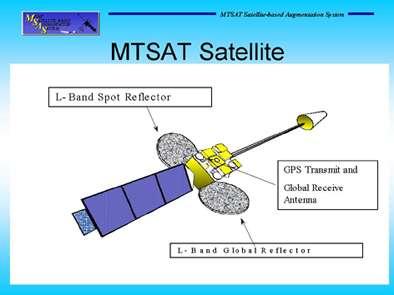
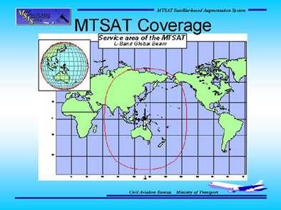
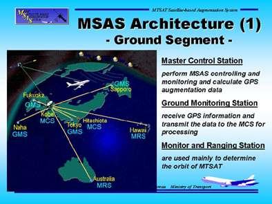
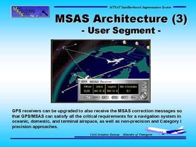
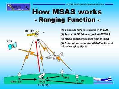
104 SBAS Augmentation Systems SBAS - MTSAT Dr. ROBERT LOH Innovative Solutions International Mr. NAOTO ASADA Japanese Flight Inspection Unit


105


106

107

108


109
110

111

112

113


114


115

116
117 GBAS Augmentation Systems GBAS Standardized system (ICAO) Ms. MARIA DIPASQUANTONIO FAA LAAS IPT Lead

118


119


120


121

122


123

124


125

126
127 GBAS Augmentation Systems Future Enhancements Mr. CURT KEEDY Flight Inspection Policy and Standards -FAA
128 GPS MODERNIZATION Curt Keedy FAA Flight Inspection Operations Policy and Standards SYSTEM EVOLUTION DoD approved GPS for development launched first of 10 Block I (first generation) satellites for test and evaluation DoD approved implementation of an operational system DoD contract with Rockwell Space Division for 28 satellites launch of first Block II (second-generation) satellite. Modified Block IIA (third generation) with additional onboard data memory, launched after ninth Block II GPS declared operational (ground segment and between 24 and 27 operational satellites since) DoD contract with Lockheed-Martin Astro-Space for 21 Block IIR (third generation) satellites first successful launch of Block IIR DoD contract with Boeing Space Division for 30 satellites. First six will be Block IIF (fourth generation) with option for six more to sustain the constellation. Remaining 24 await final determination of new capabilities/modernization (GPS III). SIGNAL TRANSMISSION Spacecraft to earth transmissions on L1 and L2. L MHz - modulated by two pseudorandom noise (PRN) codes - coarse acquisition - C/A-code - at a bit (chipping) rate of 1,023 Mcps - precision/secure - P/(Y)-code - at a chipping rate of Mcps. L MHz - modulated with P/(Y)-code. - L2 primarily used for ionospheric group delay corrections, which can cause ranging errors of as much as 40 meters - transmitted power is -6 db lower than L1 CONSTELLATION STATUS 29 Healthy Satellites - 26 Block II/IIA on orbit (life expectancy extended another two years to 10.6) - 3 Block IIR satellites on orbit (last launch May 2000) - 21 Block IIR procured
129 - First six Block IIF satellites on contract - options for 27 additional Four launches likely over next two years PRESIDENTIAL DECISION DIRECTIVE Free to peaceful use worldwide Dual civil/military system Turn off SA by 2006 Military/civil Interagency GPS Executive Board (IGEB) to manage GPS DoD must: - Protect friendly use - Prevent adversary use - Preserve civil use outside area of operations WHY MODERNIZE? Support to civil users: - new civil signals for improved accuracy, integrity and continuity - robustness - compatibility with civil aviation systems Support for defense operations: - more signal power - anti-jam - more secure military code structure - more user equipment anti-jam - able to deny enemy use of GPS GPS USER "WANTS" Defense wants: - more jam resistance - more security - shorter time to first fix - backward compatibility Defense Solution - M-code (L1/L2) - higher power - spectral separation from civil signals - faster signal acquisition - improved security codes Civil wants: - accuracy - availability - coverage - integrity - robustness (more power and redundant signals)
130 Civil Solution - C/A-code (L2) and L5 - SA off - Second civil signals for ionospheric correction and redundancy - Third civil signal for improved accuracy and real-time applications - Spectrum protection for safety-of-life applications SELECTIVE AVAILABILITY - May 2000 Selective Availability (SA) set to zero (0) in May SIGNAL EVOLUTION Second Non-Aviation Civil Signal on L2. FAA opposes the use of L2 for aviation safety applications because ITU has authorized this band for use on a co-primary basis with radiolocation services (high power radars) which may cause unacceptable levels of interference. Third Civil Signal on L5 ( MHz) in the Aeronautical Radio Navigation Service (ARNS) band. ITU must designate a satellite-to-earth transmission classification for this band (currently ground-to-air). Existing C/A-codes on L1 and P/(Y)-codes on L1 and L2 will be retained for backward compatibility. Continuation of these codes is necessary until modernized spacecraft transmitting the new signals for civil and military users are deployed and user equipment is available. (10-25 years). Plans are to continue C/A-codes on L1 and transmit C/A-codes on L2 from replenishment satellites.
131 New L5 signal will consist of a Mcps code rate with a code length of 10,230 bits. This high-rate code sequence will provide improved ranging accuracy, lower code-noise floor, better cross-correlation properties, acceptable acquisition times, better isolation between codes and reduced multipath interference. L5 will transmit two signals in phase quadrature. One will not carry data modulation and will provide advantages for accurate phase tracking and more precise carrierphase measurements. P/(Y)-code on L1 and L2 have an extremely long sequence (~1013 bits) with a period of seven days. Acquisition of this code is difficult without some knowledge of the code timing. P/(Y)-code acquisition involves acquiring the C/A-codes on L1 (short sequence - 1 millisecond) first. The C/A-code message contains timing data that provides an authorized user with information for acquiring the P/(Y)-code. DoD wants to acquire their secure signals without using the civil codes first. M-Code is "split spectrum" secure code on L1 and L2. Code will have a bit rate of 3-8 Mbps modulated on dual carriers spaced 6-9 MHz above and below the center of L1 and L2 bands. DoD will retain P/(Y)-codes until the M-code signals are generally available. Phaseover is expected to take until 2020, based on the current rate of spacecraft replacement. POWER In general - a 3 to 6 db increase in power for all civil signals C/A-code on L1 and L2 = -160 dbw P/(Y)-code on L2 (normally used for ionospheric corrections in past) will increase by 6 db L5 signal in ARNS band will require a power level 6 db greater that the CA-code on L1 to compensate for higher levels of interference and noise in this band. Military signals on L1 and L2 will be 6-10 db higher than they are now. MODERNIZATION PROGRAM Modify Block IIR (up to 12 satellites) - Second civil signal - C/A-code on L2 - M-code on L1 and L2 - Continue military P/(Y)-code on L1 and L2 - More power for all signal services - Provide 14 days of operation without contact from control and up to 180 days of operation when operating in the autonomous navigation (AUTONAV) mode. Spacecraft maintain their accuracy by communicating with other IIR satellites in orbit (cross-link ranging). Modify Block IIF (6 already under development) - Second civil signal - C/A-code on L2 - Third civil signal - new civil code on L5
132 - M-code on L1 and L2 - Continue military P/(Y)-code on L1 and L2 - More power for all signal services GPS III - Assess future system level requirements to System Architecture/Requirements Phase - Program Definition/Risk Reduction Phase - Engineering/Manufacturing/Development Phase Operational Ground Control Segment - Support Block IIR, IIF testing and operational capability - Addition of six National Imagery and Mapping Administration (NIMA) ground stations to the tracking network - improve quality and timeliness of (latency) of tracking measurements and computed parameters submeter ephemeris accuracy that will improve to decimeter range. - System Test Bed to validate signals and prototype user equipment SCHEDULE Last 12 Block IIRs - add second civil signal (C/A on L2) - new military signal (M-code) - more signal power First 6 Block IIFs - all of above capabilities plus new third civil signal in protected band (L5). Next [nominally] 6 Block IIFs - procured as necessary to sustain the constellation. GPS III (Full Modernization) - meets future requirements through more M- code signal power First modernized launch (Block IIR) First Block IIF launch M-code (earth coverage) IOC (18 satellites) 2008 Full Performance IOC 2016 OCS - evolutionary incremental development

133 TIMELINE IMPACT More anti-jam for defense - GPS accuracy maintained closer to the target in a high jamming environment More secure, robust military signal service - assured acquisition of the GPS signal when needed in a hostile electronic environment Deny enemy the military advantage of GPS - Protect friendly force operations - Preserve peaceful GPS use outside Area of Operations Availability of additional civil GPS signals - compatibility with GPS signals for civil aviation
EGNOS The first European implementation of GNSS Project status overview
 EGNOS The first European implementation of GNSS Project status overview L. Gauthier, P. Michel, J. Ventura-Traveset European Space Agency, 18 avenue Edouard Belin, 31055 Toulouse Cedex (France) Tel: (33)
Prepared by Dr. Javier Ventura-Traveset
 Prepared by Dr. Javier Ventura-Traveset EGNOS Project Office. Toulouse (France). European Space Agency. EGNOS Receiver Manufacturers Workshop, Paris, ESA HQ, July 3, 2003 Page 1 EUROPEAN GNSS STRATEGY
EGNOS Operations Oper and T and heir T Planned Ev E olution v
 EGNOS Operations a Th P Evo EGNOS Laurent Gauthier, Javier Ventura-Traveset, Felix Toran Navigation Department, ESA Directorate of European Union and Industrial Programmes, Toulouse, France Chantal de
Proceedings of Al-Azhar Engineering 7 th International Conference Cairo, April 7-10, 2003.
 Proceedings of Al-Azhar Engineering 7 th International Conference Cairo, April 7-10, 2003. MODERNIZATION PLAN OF GPS IN 21 st CENTURY AND ITS IMPACTS ON SURVEYING APPLICATIONS G. M. Dawod Survey Research
European Geostationary Navigation Overlay Service (EGNOS) Capability on Sirius 5 Satellite for SES
 Capability on Sirius 5 Satellite for SES") 21 October 2009 SES SIRIUS European Geostationary Navigation Overlay Service (EGNOS) Capability on Sirius 5 Satellite for SES Mike Pavloff, Executive Director, Space Systems/Loral Information included
21 October 2009 SES SIRIUS European Geostationary Navigation Overlay Service (EGNOS) Capability on Sirius 5 Satellite for SES Mike Pavloff, Executive Director, Space Systems/Loral Information included
ASSEMBLY 37TH SESSION
 International Civil Aviation Organization WORKING PAPER A37-WP/195 1 22/9/10 (Information paper) ASSEMBLY 37TH SESSION TECHNICAL COMMISSION Agenda Item 35: The Global Air Traffic Management (ATM) System
GNSS Programme. Overview and Status in Europe
 GNSS Programme Overview and Status in Europe Inaugural Forum Satellite Positioning Research and Application Center 23 April 2007 Tokyo Presented by Thomas Naecke (European Commission) Prepared by Daniel
Galileo & EGNOS Programmes Status
 Galileo & EGNOS Programmes Status Ugo Celestino, European Commission EURO-MEDITERRANEAN TRANSPORT FORUM GNSS WORKING GROUP 16 th October 2012 17 October, 2012 The European GNSS Programmes 2 Table of contents
Interoperability between EGNOS and WAAS: Tests Using ESTB and NSTB
 Interoperability between EGNOS and WAAS: Tests Using ESTB and NSTB Javier Ventura-Traveset, J.C. de Mateo (European Space Agency) Jorge Nieto, Ignacio García (GMV, S.A.) H. Delfour, J.M. Pieplu (ASPI)
DGPS AND EGNOS SYSTEMS IN HYDROGRAPHIC SURVEY ACCURACY ANALYSES AT THE POLISH SEA AREA CEZARY SPECHT
 DGPS AND EGNOS SYSTEMS IN HYDROGRAPHIC SURVEY ACCURACY ANALYSES AT THE POLISH SEA AREA CEZARY SPECHT Polish Naval Academy, 8-3 Gdynia 3, Smidowicza 69 str., Poland C.Specht@amw.gdynia.pl Problem of positioning
GPS/WAAS Program Update
 GPS/WAAS Program Update UN/Argentina Workshop on the Applications of GNSS 19-23 March 2018 Cordoba, Argentina GNSS: A Global Navigation Satellite System of Systems Global Constellations GPS (24+3) GLONASS
Galileo - European Global Navigation Satellite System
 Abstract Galileo - European Global Navigation Satellite System Wu Chen Department of Land Surveying and Geoinformatics Hong Kong Polytechnic University e-mail: Lswuchen@polyu.du.hk Washington Yotto Ochieng
Radio Navigation Aids Flight Test Seminar
 Radio Navigation Aids Flight Test Seminar FLIGHT INSPECTION IN THE NEW MILLENNIUM Curt Keedy FAA Flight Inspection Policy and Standards Change, Challenge, and Opportunity CHANGES Global Positioning system
GALILEO Research and Development Activities. Second Call. Area 1A. Statement of Work
 GALILEO Research and Development Activities Second Call Area 1A GNSS Introduction in the Maritime Sector Statement of Work Rue du Luxembourg, 3 B 1000 Brussels Tel +32 2 507 80 00 Fax +32 2 507 80 01 www.galileoju.com
Final Project Report. Abstract. Document information
 Final Project Report Document information Project Title Multi-constellation GNSS Airborne Navigation Systems Project Number 09.27 Project Manager Thales Avionics Deliverable Name Final Project Report Deliverable
The Mid-term Review of the European Satellite Radio Navigation Programmes Galileo and EGNOS: Questions and Answers
 MEMO/11/26 Brussels, 18 th January 2011 The Mid-term Review of the European Satellite Radio Navigation Programmes Galileo and EGNOS: Questions and Answers See also IP/11/42 For the full text of the Communication
The European Satellite Radio Navigation Programmes Galileo and EGNOS: Questions and Answers
 MEMO/11/326 Brussels, 23 May 2011 The European Satellite Radio Navigation Programmes Galileo and EGNOS: Questions and Answers What is satellite navigation? Satellite navigation is based on the principle
Global Navigation Satellite Systems (GNSS)
") Global Navigation Satellite Systems (GNSS) Pat Norris MRAeS, FRIN LogicaCMG Business Development Manager Chairman, RAeS Space Group LogicaCMG 2006. All rights reserved 2 Global Navigation Satellite Systems
Global Navigation Satellite Systems (GNSS) Pat Norris MRAeS, FRIN LogicaCMG Business Development Manager Chairman, RAeS Space Group LogicaCMG 2006. All rights reserved 2 Global Navigation Satellite Systems
The EU Satellite Navigation programmes status Applications for the CAP
 The EU Satellite Navigation programmes status Applications for the CAP Michaël MASTIER European Commission DG ENTR GP3 GNSS Applications, Security and International aspects GPS Workshop 2010 Montpellier
ICAO policy on GNSS, GNSS SARPs and global GNSS developments. Jim Nagle Chief, Communication, Navigation and Surveillance Section ICAO
 ICAO policy on GNSS, GNSS SARPs and global GNSS developments Jim Nagle Chief, Communication, Navigation and Surveillance Section ICAO Presentation overview Introduction GNSS developments in ICAO ICAO policy
The Galileo and EGNOS Programmes
 The Galileo and EGNOS Programmes Dominic Hayes European Commission ignss, Gold Coast, 14 July 2015 The European GNSS Programmes 2 Organisation and Contractual Frameworks European Union Member States (28)
Nigerian Communications Satellite Ltd. (NIGCOMSAT)
") OVERVIEW OF NIGERIAN SATELLITE AUGMENTATION SYSTEM COMMENCING WITH PILOT DEMONSTRATION TO VALIDATE NATIONAL WORK PLAN presented by Dr. Lawal Lasisi Salami, NIGERIAN COMMUNICATIONS SATELLITE LTD UNDER FEDERAL
OVERVIEW OF NIGERIAN SATELLITE AUGMENTATION SYSTEM COMMENCING WITH PILOT DEMONSTRATION TO VALIDATE NATIONAL WORK PLAN presented by Dr. Lawal Lasisi Salami, NIGERIAN COMMUNICATIONS SATELLITE LTD UNDER FEDERAL
Status of the European EGNOS and Galileo Programmes. Frank Udnaes Galileo policy and Infrastructure group EC DG-TREN. June 2008
 Status of the European EGNOS and Galileo Programmes Frank Udnaes Galileo policy and Infrastructure group EC DG-TREN EUROPEAN COMMISSION z June 2008 Galileo An infrastructure 30 satellite Constellation
SATELLITE BASED AUGMENTATION SYSTEM (SBAS) FOR AUSTRALIA
 FOR AUSTRALIA") SATELLITE BASED AUGMENTATION SYSTEM (SBAS) FOR AUSTRALIA AN AIN POSITION PAPER SUBMITTED TO VARIOUS GOVERNMENT DEPARTMENTS BY MR KYM OSLEY AM, CSC, EXEC SECRETARY AIN What are GNSS Augmentation Systems?
SATELLITE BASED AUGMENTATION SYSTEM (SBAS) FOR AUSTRALIA AN AIN POSITION PAPER SUBMITTED TO VARIOUS GOVERNMENT DEPARTMENTS BY MR KYM OSLEY AM, CSC, EXEC SECRETARY AIN What are GNSS Augmentation Systems?
EGNOS status and performance in the context of marine navigation requirements
 EGNOS status and performance in the context of marine navigation requirements J. Cydejko Gdynia Maritime University, Gdynia, Poland ABSTRACT: The current status of EGNOS (December 2006) is described as
ELEVENTH AIR NAVIGATION CONFERENCE. Montreal, 22 September to 3 October 2003 TOOLS AND FUNCTIONS FOR GNSS RAIM/FDE AVAILABILITY DETERMINATION
 19/9/03 ELEVENTH AIR NAVIGATION CONFERENCE Montreal, 22 September to 3 October 2003 Agenda Item 6 : Aeronautical navigation issues TOOLS AND FUNCTIONS FOR GNSS RAIM/FDE AVAILABILITY DETERMINATION (Presented
RESPONSE TO THE HOUSE OF COMMONS TRANSPORT SELECT COMMITTEE INQUIRY INTO GALILEO. Memorandum submitted by The Royal Academy of Engineering
 RESPONSE TO THE HOUSE OF COMMONS TRANSPORT SELECT COMMITTEE INQUIRY INTO GALILEO Memorandum submitted by The Royal Academy of Engineering September 2004 Executive Summary The Royal Academy of Engineering
GALILEO Research and Development Activities. Second Call. Area 3. Statement of Work
 GALILEO Research and Development Activities Second Call Area 3 Innovation by Small and Medium Enterprises Statement of Work Rue du Luxembourg, 3 B 1000 Brussels Tel +32 2 507 80 00 Fax +32 2 507 80 01
SBAS solution GCC, Yemen and Iraq System baseline and performance
 SBAS solution GCC, Yemen and Iraq System baseline and performance ACAC Workshop Rabat 7 & 8 November 2017 1 2017 Thales Alenia Space PROPRIETARY C O M MINFORMATION E R C I A L I N THALES C O ALENIA N F
IMPLEMENTATION OF AN SBAS-SACCSA TEST BED IN THE CAR/SAM REGIONS. (Presented by the Secretariat) SUMMARY
 SUMMARY") RLA/03/902 RCC/9 - WP/10 12/06/13 International Civil Aviation Organization South American Regional Office - Project RLA/03/902 Transition to GNSS/SBAS in the CAR/SAM Regions SACCSA Phase III Ninth Meeting
RLA/03/902 RCC/9 - WP/10 12/06/13 International Civil Aviation Organization South American Regional Office - Project RLA/03/902 Transition to GNSS/SBAS in the CAR/SAM Regions SACCSA Phase III Ninth Meeting
SNAV: SBAS self-standing Navigation Payload based on Artemis Experience.
 SNAV: SBAS self-standing Navigation Payload based on Artemis Experience. S. Badessi, G. Oppenhäuser, J. Ventura-Traveset European Space Agency F. Palamidessi, G. Leggeri Alenia Aerospazio Abstract The
Future Concepts for Galileo SAR & Ground Segment. Executive summary
 Future Concepts for Galileo SAR & Ground Segment TABLE OF CONTENT GALILEO CONTRIBUTION TO THE COSPAS/SARSAT MEOSAR SYSTEM... 3 OBJECTIVES OF THE STUDY... 3 ADDED VALUE OF SAR PROCESSING ON-BOARD G2G SATELLITES...
European GNSS Evolution
 Ref. Ares(204)902599 - /06/204 European GNSS Evolution Hermann Ebner Galileo and EGNOS Programme Management DG Enterprise and Industry Content Introduction 2 2 Major Challenges for EGNSS Evolution 3 EGNSS
Report of the Working Group B: Enhancement of Global Navigation Satellite Systems (GNSS) Services Performance
 Services Performance") Report of the Working Group B: Enhancement of Global Navigation Satellite Systems (GNSS) Services Performance 1. The Working Group on Enhancement of Global Navigation Satellite Systems (GNSS) Service Performance
Report of the Working Group B: Enhancement of Global Navigation Satellite Systems (GNSS) Services Performance 1. The Working Group on Enhancement of Global Navigation Satellite Systems (GNSS) Service Performance
EUROPEAN COMMISSION Mission High Level Definition
 Mission High Level Definition April 3, 2001 Issue 2.0, 3 rd April 2001 Table of Contents Abstract... 1 1. Introduction... 2 1.1 Scope and Objective of the Document... 2 1.2 Approval and Management of the
DEFINING THE FUTURE OF SATELLITE SURVEYING WITH TRIMBLE R-TRACK TECHNOLOGY
 DEFINING THE FUTURE OF SATELLITE SURVEYING WITH TRIMBLE R-TRACK TECHNOLOGY EDMOND NORSE, GNSS PORTFOLIO MANAGER, TRIMBLE SURVEY DIVISION WESTMINSTER, CO USA ABSTRACT In September 2003 Trimble introduced
Challenges and Solutions for GPS Receiver Test
 Challenges and Solutions for GPS Receiver Test Presenter: Mirin Lew January 28, 2010 Agenda GPS technology concepts GPS and GNSS overview Assisted GPS (A-GPS) Basic tests required for GPS receiver verification
GLOBAL NAVIGATION SATELLITE SYSTEMS (GNSS) ECE 2526E Tuesday, 24 April 2018
 ECE 2526E Tuesday, 24 April 2018") GLOBAL NAVIGATION SATELLITE SYSTEMS (GNSS) ECE 2526E Tuesday, 24 April 2018 MAJOR GLOBAL NAVIGATION SATELLITE SYSTEMS (GNSS) Global Navigation Satellite System (GNSS) includes: 1. Global Position System
GLOBAL NAVIGATION SATELLITE SYSTEMS (GNSS) ECE 2526E Tuesday, 24 April 2018 MAJOR GLOBAL NAVIGATION SATELLITE SYSTEMS (GNSS) Global Navigation Satellite System (GNSS) includes: 1. Global Position System
ICG GNSS Interoperability Workshop A Civil Aviation Perspective
 Approved for Public Release; Distribution Unlimited. 13-1907. ICG GNSS Interoperability Workshop A Civil Aviation Perspective C h r i s t o p h e r J. H e g a r t y A p r i l 2 0 1 3 Disclaimer: The contents
Special Committee SC-159 Navigation Equipment Using the Global Navigation Satellite System (GNSS) (Version 13)
 (Version 13)") RTCA Paper No. 307-18/PMC-1839 December 13, 2018 TERMS OF REFERENCE Special Committee SC-159 Navigation Equipment Using the Global Navigation Satellite System (GNSS) (Version 13) REQUESTOR: Organization
RTCA Paper No. 307-18/PMC-1839 December 13, 2018 TERMS OF REFERENCE Special Committee SC-159 Navigation Equipment Using the Global Navigation Satellite System (GNSS) (Version 13) REQUESTOR: Organization
HORIZONTAL ARAIM AVAILABILITY FOR CIVIL AVIATION OPERATIONS. ARAIM Outreach event
 HORIZONTAL ARAIM AVAILABILITY FOR CIVIL AVIATION OPERATIONS ARAIM Outreach event Moses1978 copyright April 7, 2017 H-ARAIM availability for civil aviation operations 07/04/2017 1 INTRODUCTION Space Segment
Final Project Report. Abstract. Document information
 Final Project Report Document information Project Title GNSS Baseline Study Project Number 15.03.04 Project Manager LEONARDO Deliverable Name Final Project Report Deliverable ID D01 Edition 01.02.00 Template
INTERNATIONAL CIVIL AVIATION ORGANIZATION
 INTERNATIONAL CIVIL AVIATION ORGANIZATION AFI PLANNING AND IMPLEMENTATION REGIONAL GROUP EIGHTEENTH MEETING (APIRG/18) Kampala, Uganda (27 30 March 2012) Agenda Item 3: Performance Framework for Regional
SBAS DFMC performance analysis with the SBAS DFMC Service Volume software Prototype (DSVP)
") SBAS DFMC performance analysis with the SBAS DFMC Service Volume software Prototype (DSVP) D. Salos, M. Mabilleau, Egis Avia C. Rodriguez, H. Secretan, N. Suard, CNES (French Space Agency) Email: Daniel.salos@egis.fr
SBAS DFMC performance analysis with the SBAS DFMC Service Volume software Prototype (DSVP) D. Salos, M. Mabilleau, Egis Avia C. Rodriguez, H. Secretan, N. Suard, CNES (French Space Agency) Email: Daniel.salos@egis.fr
Special Committee SC-159 Navigation Equipment Using the Global Navigation Satellite System (GNSS) (Version 11)
 (Version 11)") RTCA Paper No. 094-18/PMC-1737 March 22, 2018 TERMS OF REFERENCE Special Committee SC-159 Navigation Equipment Using the Global Navigation Satellite System (GNSS) (Version 11) REQUESTOR: Organization Person
RTCA Paper No. 094-18/PMC-1737 March 22, 2018 TERMS OF REFERENCE Special Committee SC-159 Navigation Equipment Using the Global Navigation Satellite System (GNSS) (Version 11) REQUESTOR: Organization Person
EGNOS System Testbed Status and Achievements
 EGNOS System Testbed Status and Achievements H. Secretan (1), N. Suard (1), J. Carlos de Mateo (2), A Cruz (3) (1) CNES, GNSS1 P.O, European Space Agency, 18 Av. Edouard Belin 31401 Toulouse Cedex4, France
EGNOS: The first European implementation of GNSS - Project Status
 IAF 01 M.3.02 EGNOS: The first European implementation of GNSS - Project Status René Oosterlinck (1), Laurent Gauthier (2) European Space Agency (ESA), 18 avenue Edouard Belin, 31055 Toulouse Cedex (France)
Horizontal Advanced RAIM: Operational Benefits and Future Challenges
 Horizontal Advanced RAIM: Operational Benefits and Future Challenges International Technical Symposium on Navigation and Timing 2015 Session Air Navigation November 2015 Toulouse/France 1 ICAO ABAS augmentation
EGNOS: The first European implementation of GNSS. Project status overview
 EGNOS: The first European implementation of GNSS. Project status overview L. Gauthier, P. Michel and J. Ventura-Traveset European Space Agency (ESA), 18 avenue Edouard Belin, 31055 Toulouse Cedex (France)
Global Positioning Systems Directorate
 Space and Missile Systems Center Global Positioning Systems Directorate GPS Program Update to 8 th Stanford PNT Symposium 30 Oct 2014 Col Matt Smitham Deputy Director, GPS Directorate Global Positioning
ORBITAL NAVIGATION SYSTEMS PRESENT AND FUTURE TENDS
 ORBITAL NAVIGATION SYSTEMS PRESENT AND FUTURE TENDS CONTENT WHAT IS COVERED A BRIEF HISTORY OF SYSTEMS PRESENT SYSTEMS IN USE PROBLEMS WITH SATELLITE SYSTEMS PLANNED IMPROVEMENTS CONCLUSION CONTENT WHAT
Implementing the International Safety Framework for Space Nuclear Power Sources at ESA Options and Open Questions
 Implementing the International Safety Framework for Space Nuclear Power Sources at ESA Options and Open Questions Leopold Summerer, Ulrike Bohlmann European Space Agency European Space Agency (ESA) International
Wide Area Augmentation System (WAAS)
") Wide Area Augmentation System (WAAS) Ionospheric Effects Symposium By: Jason Burns Technology Evolution Lead Date: Agenda WAAS Overview Ionospheric Effects on WAAS Future Plans User Segment Update 2 WAAS
Wide Area Augmentation System (WAAS) Ionospheric Effects Symposium By: Jason Burns Technology Evolution Lead Date: Agenda WAAS Overview Ionospheric Effects on WAAS Future Plans User Segment Update 2 WAAS
International Programmes & GNSS Monitoring
 International Programmes & GNSS Monitoring Patrizio Vanni (patrizio.vanni@enav.it) GNSS expert ICAO PBN and PANS-OPS Provisions Implementation workshop Lisbon, 26 August 2015 Participation to PBN/GNSS
GNSS: CNS Dependencies
 GNSS: CNS Dependencies Lendina Smaja DATM/RDS/NAV 10 March 2015 Agenda The Future Technical Environment GNSS GNSS Supporting CNS Loss of Signal Impact GNSS: CNS Dependencies 2 Original FANS CNS/ATM Concept
REPORT OF COMMITTEE B TO THE CONFERENCE ON AGENDA ITEM 6
 1/10/03 ELEVENTH AIR NAVIGATION CONFERENCE Montreal, 22 September to 3 October 2003 REPORT OF COMMITTEE B TO THE CONFERENCE ON AGENDA ITEM 6 The attached report has been approved by Committee B for submission
New Funding Opportunities to Support Safety of Navigation: EGNOS and Galileo
 New Funding Opportunities to Support Safety of Navigation: EGNOS and Galileo e-navigation Underway 31 January-2 February 2017 GSA 2016 The European GNSS Agency (GSA) today: Staff: about 145 Nationalities:
European GNSS Applications in H2020
 European GNSS Applications in H2020 Countdown to H2020 12.12.2013, Brussels Carmen Aguilera European GNSS Agency Agenda European GNSS Agency EU-GNSS market potential FP7- experience and results H2020 opportunities
An Introduction to Airline Communication Types
 AN INTEL COMPANY An Introduction to Airline Communication Types By Chip Downing, Senior Director, Aerospace & Defense WHEN IT MATTERS, IT RUNS ON WIND RIVER EXECUTIVE SUMMARY Today s global airliners use
Satellite navigation applications: opportunities from the European GNSS. Fiammetta Diani Deputy Head of Market Development European GNSS Agency
 Satellite navigation applications: opportunities from the European GNSS Fiammetta Diani Deputy Head of Market Development European GNSS Agency FP7 success story in Lithuania COSUDEC Coastal Surveying of
PRELIMINARY PROGRAMME
 ICG EXPERTS MEETING: GLOBAL NAVIGATION SATELLITE SYSTEMS SERVICES 14-18 December 2015 Vienna International Centre, Vienna, Austria Organized by International Committee on Global Navigation Satellite Systems
EGNOS GEO Transponder Service Replenishment
 EUROPEAN COMMISSION DIRECTORATE-GENERAL FOR ENERGY AND TRANSPORT DIRECTORATE G - Maritime transport, Galileo & Intelligent transport G.3 - EU satellite navigation programmes: Infrastructure, Deployment
Global Navigation Satellite System (GNSS) GPS Serves Over 400 Million Users Today. GPS is used throughout our society
 GPS Serves Over 400 Million Users Today. GPS is used throughout our society") Global avigation Satellite System (GSS) For freshmen at CKU AA December 10th, 2009 by Shau-Shiun Jan ICA & IAA, CKU Global avigation Satellite System (GSS) GSS (Global Positioning System, GPS) Basics Today
Global avigation Satellite System (GSS) For freshmen at CKU AA December 10th, 2009 by Shau-Shiun Jan ICA & IAA, CKU Global avigation Satellite System (GSS) GSS (Global Positioning System, GPS) Basics Today
Indian GNSS Industry Overview Challenges and future prospects
 Indian GNSS Industry Overview Challenges and future prospects Expert Presentation By Dr. S.V. Kibe Consultant, SATCOM & GNSS, Bangalore, India (Former Programme Director, SATNAV,ISRO HQ) On February 20,2013
AEEC 2013 Presentation to the Airlines and the Aviation Industry
 AEEC 2013 Presentation to the Airlines and the Aviation Industry Multi-Frequency/Multi-Constellation (MFMC) GNSS Receivers Value for Aviation and Airlines John Studenny CMC GPS Product Manager Alain Beaulieu
ARTES 1 ROLLING WORKPLAN 2010
 ARTES 1 ROLLING WORKPLAN 2010 INTRODUCTION This document presents the ARTES 1 Rolling Workplan for 2010. Activities have been selected based on the ARTES Call for Ideas, consultation with participating
Space and Missile Systems Center
 Space and Missile Systems Center Global Positioning Systems Directorate GPS Status & Modernization Progress: Service, Satellites, Control Segment, and Military GPS User Equipment 3 Nov 2016 Col Steve Whitney,
Satellite-Based Augmentation System (SBAS) Integrity Services
 Integrity Services") Satellite-Based Augmentation System (SBAS) Integrity Services Presented To: Munich, Germany Date: March 8, 2010 By: Leo Eldredge, Manager GNSS Group, FAA FAA Satellite Navigation Program 2 Wide Area Augmentation
Satellite-Based Augmentation System (SBAS) Integrity Services Presented To: Munich, Germany Date: March 8, 2010 By: Leo Eldredge, Manager GNSS Group, FAA FAA Satellite Navigation Program 2 Wide Area Augmentation
Future Aeronautical Communication System - FCI
 Future Aeronautical Communication System - FCI Nikos Fistas, EUROCONTROL/CND TAKE OFF Conference Salzburg, April 21 st 2009 Content Context-History Current ECTL activities SESAR dimension What s next What
Centralised Services 7-2 Network Infrastructure Performance Monitoring and Analysis Service
 EUROCONTROL Centralised Services 7-2 Network Infrastructure Performance Monitoring and Analysis Service Monitoring the performance of 1030/1090 MHz RF bands A COST-EFFICIENT SOLUTION To make best use of
GLObal Navigation Satellite System (GLONASS)
") FEDERAL SPACE AGENCY GLObal Navigation Satellite System (GLONASS) Sergey Revnivykh Deputy Director General Central Research Institute of Machine Building Head of PNT Center 4-th meeting of International
FEDERAL SPACE AGENCY GLObal Navigation Satellite System (GLONASS) Sergey Revnivykh Deputy Director General Central Research Institute of Machine Building Head of PNT Center 4-th meeting of International
EC UA Aviation Conference, Windhoek, Namibia, April 2 & 3, 2009
 EC UA Aviation Conference, Windhoek, Namibia, April 2 & 3, 2009 Session 7 : EU-Africa Civil Aviation Co-operation 1 Contents Page 2 Who is Thales Alenia Space Thales Alenia Space contribution to Air Traffic
SAMARA Satellite communication system for Atm service
 SAMARA Satellite communication system for Atm service System & Payload Solutions for Small GEO Platforms ESTEC Noordwijk, 6th February 2009 Thales Alenia Space Italia Thales Alenia Space Espana Thales
GPS Modernization and Program Update
 GPS Modernization and Program Update GPS Update to ION Southern California Chapter 22 Feb 2011 Colonel Bernie Gruber Director Global Positioning Systems Directorate Contents Current Constellation Modernization
Basics of Satellite Navigation an Elementary Introduction Prof. Dr. Bernhard Hofmann-Wellenhof Graz, University of Technology, Austria
 Basics of Satellite Navigation an Elementary Introduction Prof. Dr. Bernhard Hofmann-Wellenhof Graz, University of Technology, Austria CONCEPT OF GPS Prof. Dr. Bernhard Hofmann-Wellenhof Graz, University
The last 25 years - GPS to multi-gnss: from a military tool to the most widely used civilian positioning solution
 1 The last 25 years - GPS to multi-gnss: from a military tool to the most widely used civilian positioning solution B. Hofmann-Wellenhof Institute of Geodesy / Navigation, Graz University of Technology
Overview of Galileo & EGNOS
 Overview of Galileo & EGNOS Ugo Celestino, European Commission GNSS Working Group 6 th Meeting, Brussels, 25 th September 2013 26 September, 2013 Overview of Galileo & EGNOS 2 Europe needs Galileo Galileo
GNSS Spectrum Issues and New GPS L5
 Federal Aviation Administration Washington, D.C. GNSS Spectrum Issues and New GPS L5 International Civil Aviation Organization Regional Coordination Meeting Lima, Peru March 27 28, 2001 Basic GPS System!Space
Galileo will boost economy and make life of citizens easier
 MEMO/11/717 Brussels, 21 October 2011 Galileo will boost economy and make life of citizens easier A Must have for Europe "If Europe really wants to be considered as a serious partner by the United States
ANNUAL OF NAVIGATION 11/2006
 ANNUAL OF NAVIGATION /6 MARIUSZ MIĘSIKOWSKI, ALEKSANDER NOWAK, CEZARY SPECHT Naval University of Gdynia BARTŁOMIEJ OSZCZAK University of Warmia and Mazury in Olsztyn EGNOS ACCURACY PERFORMANCE IN POLAND
Legal Issues Relevant to the Galileo Program
 Legal Issues Relevant to the Galileo Program Dr. Frans von der Dunk Co-Director, International Institute of Air and Space Law 10-09-2003 ECSL Summer Course, Leuven 1 Introduction Global Navigation Satellite
GBAS FOR ATCO. June 2017
 GBAS FOR ATCO June 2017 Disclaimer This presentation is for information purposes only. It should not be relied on as the sole source of information, and should always be used in the context of other authoritative
IMPLEMENTATION OF GNSS BASED SERVICES
 International Civil Aviation Organization IMPLEMENTATION OF GNSS BASED SERVICES Julio Siu Communications, Navigation and Surveillance Regional Officer ICAO NACC Regional Office ICAO Workshop on PBN Airspace
The EU GNSS Programmes: EGNOS, GALILEO Status & International Cooperation
 The EU GNSS Programmes: EGNOS, GALILEO Status & International Cooperation Ugo Celestino European Commission Damascus, 8 April 2010 Content EU GNSS Programmes - Galileo -EGNOS International Cooperation
Een GPS naderingshulpmiddel voor de kleine luchtvaart
 Technische ontwikkelingen: Een GPS naderingshulpmiddel voor de kleine luchtvaart Christian Tiberius Faculteit Luchtvaart- en Ruimtevaarttechniek TU Delft WORKSHOP Is er nog Lucht(ruim) voor de Kleine Luchtvaart
Interoperability Test Analysis between EGNOS and MSAS SBAS Systems
 Interoperability Test Analysis between EGNOS and MSAS SBAS Systems Abstract: Jorge Nieto, Joaquin Cosmen, Ignacio García, GMV, S.A. Javier Ventura-Traveset, Isabel Neto, European Space Agency (ESA) Bernd
GALILEO Research and Development Activities. Second Call. Area 3. Coordination of Galileo Research & Development activities.
 GALILEO Research and Development Activities Second Call Area 3 Coordination of Galileo Research & Development activities Statement of Work Rue du Luxembourg, 3 B 1000 Brussels Tel +32 2 507 80 00 Fax +32
Technical Specifications Document. for. Satellite-Based Augmentation System (SBAS) Testbed
 Testbed") Technical Specifications Document for Satellite-Based Augmentation System (SBAS) Testbed Revision 3 13 June 2017 Table of Contents Acronym Definitions... 3 1. Introduction... 4 2. SBAS Testbed Realisation...
Technical Specifications Document for Satellite-Based Augmentation System (SBAS) Testbed Revision 3 13 June 2017 Table of Contents Acronym Definitions... 3 1. Introduction... 4 2. SBAS Testbed Realisation...
GALILEO JOINT UNDERTAKING
 GALILEO Research and development activities First call Activity A User receiver preliminary development STATEMENT OF WORK GJU/03/094/issue2/OM/ms Issue 2 094 issue2 6th FP A SOW 1 TABLE OF CONTENTS 1.
Modern ARINC 743B DO-229D and DO-253C GLSSU Solutions For Retrofit
 Commercial Aviation Modern ARINC 743B DO-229D and DO-253C GLSSU Solutions For Retrofit Presented to AEEC March 2010 The Classic Retrofit Challenge Financial: Operating budget year financing ROI payback:
EGNOS System Test Bed Status and Achievements
 EGNOS System Test Bed Status and Achievements H. Secretan (1), N. Suard (1), R. Hanssen (2), J-M. Gaubert, P. Gouni (3), A Cruz (4) (1) ESA/CNES, European Space Agency, Toulouse, France (2) NMA, Norwegian
IMO WORLD-WIDE RADIONAVIGATION SYSTEM (WWRNS) GALILEO receiver performance standards. Submitted by the European Commission
 GALILEO receiver performance standards. Submitted by the European Commission") INTERNATIONAL MARITIME ORGANIZATION E IMO SUB-COMMITTEE ON SAFETY OF NAVIGATION 50th session Agenda item 13 2 April 2004 Original: ENGLISH WORLD-WIDE RADIONAVIGATION SYSTEM (WWRNS) GALILEO receiver performance
INTERNATIONAL MARITIME ORGANIZATION E IMO SUB-COMMITTEE ON SAFETY OF NAVIGATION 50th session Agenda item 13 2 April 2004 Original: ENGLISH WORLD-WIDE RADIONAVIGATION SYSTEM (WWRNS) GALILEO receiver performance
GNSS-based Flight Inspection Systems
 GNSS-based Flight Inspection Systems Euiho Kim, Todd Walter, and J. David Powell Department of Aeronautics and Astronautics Stanford University Stanford, CA 94305, USA Abstract This paper presents novel
Global Navigation Satellite System (GLONASS): Status and Development
: Status and Development") Global Navigation Satellite System (GLONASS): Status and Development Tatiana Mirgorodskaya Information and Analysis Center for Positioning, Navigation and Timing Roscosmos State Corporation UN-Nepal Workshop
Global Navigation Satellite System (GLONASS): Status and Development Tatiana Mirgorodskaya Information and Analysis Center for Positioning, Navigation and Timing Roscosmos State Corporation UN-Nepal Workshop
ESA Iris Programme Analysis & definition of the Satellite System Operations. Briefing 28 July
 ESA Iris Programme Analysis & definition of the Satellite System Operations Briefing 28 July 2009 - Nathalie.Ricard@esa.int 1 Analysis & Definition of Satellite Operations Study rationale ESA s involvement
GLONASS PROGRAMME UPDATE
 GLONASS PROGRAMME UPDATE Ivan Revnivykh Roscosmos State Space Corporation 11 th Meeting of the International Committee on Global Navigation Satellite System November 7, 2016 Sochi, Russian Federation CONTENTS
GPS Status and Modernization
 GPS Status and Modernization Nov 2011 Colonel Harold Martin PNT Command Lead AFSPC A3P "This briefing is for information only. No US Government commitment to sell, loan, lease, co-develop or co-produce
Regional and Inter-Regional Seminar and Workshop on Search and Rescue
 Regional and Inter-Regional Seminar and Workshop on Search and Rescue Mahe, Seychelles 19-22 July 2016 1 Agenda Aireon Introduction Space-Based ADS-B Overview Aireon System Deployment Status Aireon ALERT
GNSS MONITORING NETWORKS
 SPACE GNSS MONITORING NETWORKS Satellite communications, earth observation, navigation and positioning and control stations indracompany.com GNSS MONITORING NETWORKS GNSS MONITORING NETWORKS Indra s solutions
General Support Technology Programme (GSTP) Period 6 Element 3: Technology Flight Opportunities (TFO)
 Period 6 Element 3: Technology Flight Opportunities (TFO)") General Support Technology Programme (GSTP) Period 6 Element 3: Technology Flight Opportunities (TFO) Open Call for Technology Flight Demonstrators and Carrier Flight Opportunities Introduction The Agency
General Support Technology Programme (GSTP) Period 6 Element 3: Technology Flight Opportunities (TFO) Open Call for Technology Flight Demonstrators and Carrier Flight Opportunities Introduction The Agency