AN INTEGRATED FUTURE. Steve Hewitson - 8 July 2014
|
|
|
- Hortense Andrews
- 5 years ago
- Views:
Transcription

1 AN INTEGRATED FUTURE Steve Hewitson - 8 July 2014


2 Locata Commercial Model Integrated reference system for testing in a GPS contested environment Locata OEM Locata Technology Integrator (LTI) Market Product Fleet management for mining operations Vehicle guidance and automation LocataLite Rover


3 US Air Force WHITE SANDS MISSILE RANGE Ultra High Accuracy Reference System
4 White Sands Missile Range Ultra High Accuracy Reference System (UHARS) Locata Transceivers

5 White Sands Missile Range Ultra High Accuracy Reference System (UHARS) GPS Jammed Primary Requirements: 18cm 3D Accuracy PDOPS< mile (48km) Acquisition & Tracking Locata Transceivers

6 White Sands Missile Range 746 th Test Squadron Aircraft Rover Install Locata Antenna The current USAF Truth Reference For CDR trials an unmodified commercial Locata receiver was compared to this unit

7 White Sands Missile Range Network - Technical Demonstration + 10 LocataLites for Operational Network Master Tech Demo Slaves

8 White Sands Missile Range Network Master Site (NOP) USAF White Sands LocataNet covering approx 1,300 sq. miles A LocataLite Slave site
9 White Sands Missile Range Positioning Performance Altitude: 25,000 ft Ground Speed: ~300 knots Duration: 30 minute Horizontal Accuracy: ~6cm Vertical Accuracy: ~15cm 3D Accuracy: ~16cm
10 White Sands Missile Range Acquisition & Tracking Performance


11 White Sands Missile Range Transmit Site Monumentation and Hardware Quadrifiler Ant. Tx #2 Quadrifiler Ant. Tx #1 Grid Ant. Concrete Pillar #2 Met Station & Sensors PVC Pipe ~ 6 Feet J-BOX Shielded Cable to Locata Trailer


12 White Sands Missile Range Mobile Transmit Hardware Ultra-rugged, mobile, high power (10Watt Amplifiers), Continuous Operation Scheduled for operational flight testing Q4 2014

13 Newmont BODDINGTON GOLD MINE Leica Geosystems - JigSaw Position System

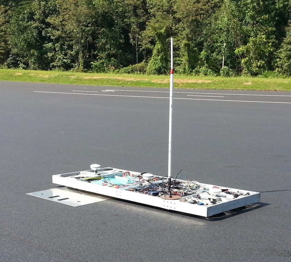
.")

14 Jassist - Positioning System Tightly Integrated GNSS+Locata Measurements in Leica s Core Algorithm Library (CAL). Co-located GNSS and Locata antennas. Well-aligned phase centres Multipath mitigating reception patterns

15 Boddington Gold Mine Current Network North Pit Current Depth: 250m 140 kms (90 miles) SE of Perth Planned Depth: 850m 4 Semi-permanent LocataLite sites 12 mobile trailers South Pit Current Depth: 300m

16 Boddington Gold Mine JPS Performance Accuracy vs GNSS only Horizontal Difference Vertical Difference

17 Boddington Gold Mine JPS Performance - Typical availability over 1 week North Pit GPS only North Pit With Locata GNSS only 75.3% Availability GNSS+Locata 99.5% Availability Began running 2 JPS receivers in April 2012 on 2 production drill rigs. Newmont now mandated all high-precision machines in mine must be fitted with Locata

18 Insurance Institute for Highway Safety VEHICLE RESEARCH CENTRE Perrone Robotics - Vehicle Automation

19 Vehicle Research Centre Driver Tow System

20 Vehicle Research Centre Perrone Robotics - Autonomous Vehicle Test System (AVTS) Primary Requirements: Highway Speeds Operational in: Outdoors Covered test tracks Indoor labs Reliable and repeatable execution of test manoeuvres. Accuracy: <5cm


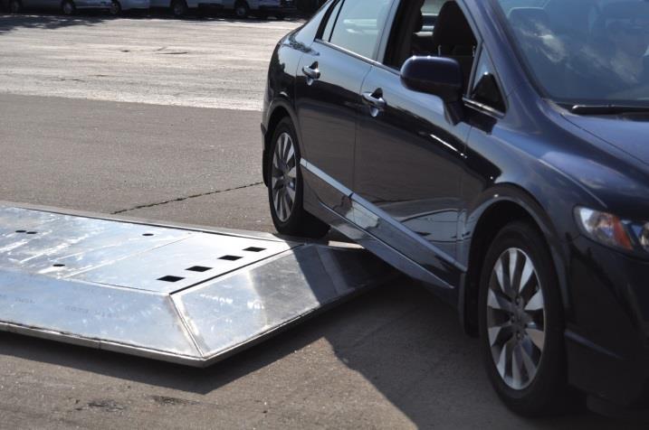
21 Vehicle Research Centre Target Vehicle

22 Vehicle Research Centre Test Vehicle Drop-in Actuator Kit (DAK)


23 Vehicle Research Centre Outdoor Transmit Sites

24 Vehicle Research Centre LocataNet Layout

25 Vehicle Research Centre Outdoor Test Track


26 Vehicle Research Centre Digital Terrain Model

27 Vehicle Research Centre Indoor Test Track

28 VRAY Correlator Beamforming


29 Multipath Antenna Gain Patterns and Beamforming Nominal Gain Pattern Phase Corrected Gain Pattern
30 Normalised Magnitude Multipath Antenna Gain Patterns and Beamforming τ 1.0 LOS Signal Constructive Multipath Constructive Multipath Signal Composite Correlation Signal τ 1 τ 0 τ N Delay [chips]

31 Normalised Magnitude Multipath Antenna Gain Patterns and Beamforming τ τ 0 τ LOS Signal Constructive Multipath Constructive Multipath Signal Composite Correlation Signal τ N Delay [chips]
32 Correlator Beamforming for GPS Receivers AFIT - Cooperative Research and Development Agreement Existing CRPA Antenna GPS VRay Antenna Multiple Radios

33 PORT AUTOMATION Market Exploration

34 Container Terminal Promising Market
Locata: A New Constellation for High Accuracy Outdoor & Indoor Positioning
 Locata: A New Constellation for High Accuracy Outdoor & Indoor Positioning Chris Rizos, Yong Li, Nonie Politi School of Surveying & Spatial Information Systems University of New South Wales, Sydney, Australia
A Positioning Technology for Classically Difficult GNSS Environments from Locata
 A Positioning Technology for Classically Difficult GNSS Environments from Locata J. Barnes, C. Rizos, M. Kanli, A. Pahwa School of Surveying & Spatial Information System, University of New South Wales,
May/June 2012 Engineering Solutions from the Global Navigation Satellite System Community Truth on the RANGE
 May/June 212 Engineering Solutions from the Global Navigation Satellite System Community www.insidegnss.com Truth on the RANGE WASHINGTON VIEW Civil GPS/Galileo Signal Patent Dispute GLONASS INTER-FREQUENCY
Open Cut Mine Machinery Automation: Going Beyond GNSS With Locata
 Open Cut Mine Machinery Automation: Going Beyond GNSS With Locata Chris Rizos School of Surveying & Spatial Information Systems University of New South Wales Brendon Lilly, Craig Robertson Leica Geosystems
The Potential of a Ground Based Transceivers Network for Water Dam Deformation Monitoring
 The Potential of a Ground Based Transceivers Network for Water Dam Deformation Monitoring J.B Barnes School of Surveying and Spatial Information Systems, University of New South Wales, Sydney, Australia
UWB for Lunar Surface Tracking. Richard J. Barton ERC, Inc. NASA JSC
 UWB for Lunar Surface Tracking Richard J. Barton ERC, Inc. NASA JSC Overview NASA JSC is investigating ultrawideband (UWB) impulse radio systems for location estimation and tracking applications on the
Long Term Performance Analysis of a New Ground-transceiver Positioning Network (LocataNet) for Structural Deformation Monitoring Applications
 for Structural Deformation Monitoring Applications") Long Term Performance Analysis of a New Ground-transceiver Positioning Network (LocataNet) for Structural Deformation Monitoring Applications Dr. Joel BARNES, Australia, Mr. Joel VAN CRANENBROECK, Belgium,
Long Term Performance Analysis of a New Ground-transceiver Positioning Network (LocataNet) for Structural Deformation Monitoring Applications Dr. Joel BARNES, Australia, Mr. Joel VAN CRANENBROECK, Belgium,
AIR FORCE INSTITUTE OF TECHNOLOGY
 PSEUDOLITE ARCHITECTURE AND PERFORMANCE ANALYSIS FOR THE FAA S NextGen AIRSPACE THESIS Joseph A. Czabaranek, Captain, USAF AFIT-ENV-13-M-07 DEPARTMENT OF THE AIR FORCE AIR UNIVERSITY AIR FORCE INSTITUTE
LOCALIZATION WITH GPS UNAVAILABLE
 LOCALIZATION WITH GPS UNAVAILABLE ARES SWIEE MEETING - ROME, SEPT. 26 2014 TOR VERGATA UNIVERSITY Summary Introduction Technology State of art Application Scenarios vs. Technology Advanced Research in
Next Generation Positioning Infrastructure
 Next Generation Positioning Infrastructure The GNSS Network in the 21 st Century Joel VAN CRANENBROECK & Partners Beyond East & West GeoSensing Community 1 INFRASTRUCTURE "The installations that form the
Combining Terrestrial and GNSS Technolgies for Geodetic Monitoring. Neil ASHCROFT Leica Geosystems Engineering Segment Manager
 Combining Terrestrial and GNSS Technolgies for Geodetic Monitoring Neil ASHCROFT Leica Geosystems Engineering Segment Manager Structural Monitoring Technolgies Introduction Monitoring Instrumentation Reflectors,
670 10/26/17 SSD: 07/14/16, 09/16/17 Page 1 of 6
 SSD: 07/14/16, 09/16/17 Page 1 of 6 S P E C I A L P R O V I S I O N Section MISCELLANEOUS INCIDENTALS Item.822 - GNSS Construction Inspection Equipment Description SAMPLE PROJECT 12345 10/30/17 1.1 Work
3D-Map Aided Multipath Mitigation for Urban GNSS Positioning
 Summer School on GNSS 2014 Student Scholarship Award Workshop August 2, 2014 3D-Map Aided Multipath Mitigation for Urban GNSS Positioning I-Wen Chu National Cheng Kung University, Taiwan. Page 1 Outline
WORLD-FIRST CONFERENCE PAPER ON LOCATA TIME SYNCHRONIZATION CAPABILITY
 OVERVIEW WORLD-FIRST CONFERENCE PAPER ON LOCATA TIME SYNCHRONIZATION CAPABILITY Presented by the University of New South Wales at the US Institute of Navigation s Precise Time & Time Interval Conference,
PECHORA-2ТМ. Air Defense Missile System
 PECHORA-2ТМ Air Defense Missile System S-125-2TM PECHORA-2TM adms S-125-2TM PECHORA-2TM MEDIUM RANGE AIR defense MISSILE SYSTEM The S-125-2TM Pechora-2TM Air Defense Missile System (ADMS) is designed to
CHC MINING DEFORMATION MONITORING SOLUTION
 CHC MINING DEFORMATION MONITORING SOLUTION Safety is first in mining. CHC offers solutions designed to improve safety for personnel on the ground and in the cab with 24/7 precision positioning for automatic
COE CST First Annual Technical Meeting: Autonomous Rendezvous & Docking Penina Axelrad. Federal Aviation. Administration.
 Administration COE CST First Annual Technical Meeting: Autonomous Rendezvous & Docking Penina Axelrad November 10, 2011 Administration 1 Overview Team Members Purpose of Task Research Methodology Results
Miniaturized GPS Antenna Array Technology and Predicted Anti-Jam Performance
 Miniaturized GPS Antenna Array Technology and Predicted Anti-Jam Performance Dale Reynolds; Alison Brown NAVSYS Corporation. Al Reynolds, Boeing Military Aircraft And Missile Systems Group ABSTRACT NAVSYS
Progress Update. RT Logic, Steve Williams. Operations Symposium & Exhibition 20 October, 2010
 Testing the Test Range without Flights Progress Update RT Logic, Steve Williams 48 th Annual Targets, UAVs and Range Operations Symposium & Exhibition 20 October, 2010 Colorado Springs, CO (719) 598-2801
GPS Multipath Reduction with Correlator Beamforming
 Air Force Institute of Technology AFIT Scholar Theses and Dissertations 3-14-2014 GPS Multipath Reduction with Correlator Beamforming Jason M. Barhorst Follow this and additional works at: https://scholar.afit.edu/etd
Assessment of high-rate GPS using a single-axis shake table
 Assessment of high-rate GPS using a single-axis shake table S. Häberling, M. Rothacher, A. Geiger Institute of Geodesy and Photogrammetry, ETH Zurich Introduction Project: Study the applicability of high-rate
Mitigate Effects of Multipath Interference at GPS Using Separate Antennas
 Mitigate Effects of Multipath Interference at GPS Using Separate Antennas Younis H. Karim AlJewari #1, R. Badlishah Ahmed *2, Ali Amer Ahmed #3 # School of Computer and Communication Engineering, Universiti
RFD900x Radio Modem Data Sheet MHz frequency band
 RFD900x Radio Modem Data Sheet 902-928MHz frequency band Product Specifications and Performance Flash Programmer User Manual Features Out of the box RF communications. Air data rate speeds of up to 750kbps
GAJET, a DRDC Evaluation Testbed for Navigation Electronic Warfare. Michel Clénet
 GAJET, a DRDC Evaluation Testbed for Navigation Electronic Warfare Michel Clénet Outline Introduction CRPA project at DRDC Ottawa GAJET: An Evaluation Test bed for GPS Anti-Jam System An AJ simulation
LOCAL DEFORMATION MONITORING USING REAL-TIME GPS KINEMATIC TECHNOLOGY: INITIAL STUDY
 LOCAL DEFORMATION MONITORING USING REAL-TIME GPS KINEMATIC TECHNOLOGY: INITIAL STUDY Donghyun (Don) Kim, Richard B. Langley, Jason Bond, and Adam Chrzanowski Department of Geodesy and Geomatics Engineering
Leica SmartStation Total Station with integrated GNSS
 Leica SmartStation Total Station with integrated GNSS Leica SmartStation Total station with integrated GNSS New revolutionary surveying system. World s first, TPS and GNSS perfectly combined. High performance
GNSS-Based Auto-Guidance Test Program Development
 ECPA (Skiathus( Skiathus,, Greece) June, GNSS-Based Auto-Guidance Test Program Development Viacheslav I. Adamchuk George E. Meyer Roger M. Hoy Michael F. Kocher George E. Meyer Michael F. Biological Systems
Dynamic Two-Way Time Transfer to Moving Platforms W H I T E PA P E R
 Dynamic Two-Way Time Transfer to Moving Platforms WHITE PAPER Dynamic Two-Way Time Transfer to Moving Platforms Tom Celano, Symmetricom 1Lt. Richard Beckman, USAF-AFRL Jeremy Warriner, Symmetricom Scott
High Gain Advanced GPS Receiver
 High Gain Advanced GPS Receiver NAVSYS Corporation 14960 Woodcarver Road, Colorado Springs, CO 80921 Introduction The NAVSYS High Gain Advanced GPS Receiver (HAGR) is a digital beam steering receiver designed
Leica SmartStation Total Station with integrated GPS
 Leica SmartStation Total Station with integrated GPS Leica SmartStation Total station with integrated GPS New revolutionary surveying system. World s first, TPS and GPS perfectly combined. High performance
Leica MNS1200 GNSS Series Toughest GNSS solution for toughest sites
 Leica MNS1200 GNSS Series Toughest GNSS solution for toughest sites >Fast >Smart >Integrated Leica MNS1200 GNSS Series Robust GNSS machine navigation solution The Leica MNS1200 GNSS (Global Navigation
Integrated GPS/TOA Navigation using a Positioning and Communication Software Defined Radio
 Integrated GPS/TOA Navigation using a Positioning and Communication Software Defined Radio Alison Brown and Janet Nordlie NAVSYS Corporation 96 Woodcarver Road Colorado Springs, CO 89 Abstract-While GPS
Locata: A New Constellation for High Accuracy Outdoor and Indoor Positioning
 Locata: A New Constellation for High Accuracy Outdoor and Indoor Positioning Chris RIZOS, Yong LI, Nonie POLITI, Joel BARNES and Nunzio GAMBALE, Australia Key words: Locata, indoor positioning, integrated
Using RTK GNSS Wisely
 Using RTK GNSS Wisely February 017 Autonomous Positioning Differential Positioning Concept: Detect and cancel identical errors with simultaneous observation. F + E = G + E 1 Static & RTK Computations Static
WATER CONSERVATION AND LANDFORMING
 WATER CONSERVATION AND LANDFORMING 2 LANDFORMING INDUSTRY LEADING LANDFORMING Proven survey, field design and landforming with GNSS accuracy. Topcon offers dual-constellation (GPS + GLONASS) satellite
swarm bee LE Development Kit User Guide
 Application Note Utilizing swarm bee radios for low power tag designsr Version Number: 1.0 Author: Jingjing Ding swarm bee LE Development Kit User Guide 1.0 NA-14-0267-0009-1.0 Document Information Document
AN/TRC - 66A RADIO SET
 Chapter 3 RADIO RELAY EQUIPMENT AN/TRC - 66A RADIO SET DESCRIPTION: The AN/TRC-66A Radio Set is a general purpose, super high frequency (SHF), line of sight (LOS), radio relay and tropospheric forward
ADS-B Ruling and FreeFlight Systems new ADS-B solutions
 ADS-B Ruling and FreeFlight Systems new ADS-B solutions EAA-Oshkosh July 2010 FreeFlight Systems Proprietary Data What is ADS-B? Current Radar System Interrogation from radar Receives response from aircraft
The DARPA 100Gb/s RF Backbone Program
 The DARPA 100Gb/s RF Backbone Program Dr. Ted Woodward Program Manager, DARPA/STO Briefing Prepared for NSF mmw RCN workshop Madison, WI 19 July 2017 1 100 Gb/s RF Backbone (100G) Objective: Capacity AND
Case Study: Land and Sea Demo v2.0 April 4 th, 2018 San Diego, CA
 Case Study: Land and Sea Demo v2.0 April 4 th, 2018 San Diego, CA Background In October 2016, Silvus conducted a demonstration of its StreamCaster 4200 2x2 MIMO MANET radios at the behest of the US NAVY.
GNSS-Based Auto-Guidance Accuracy Testing
 AETC (Louisville, Kentucky) February, GNSS-Based Auto-Guidance Accuracy Testing Viacheslav I. Adamchuk Biological Systems Engineering University of Nebraska-Lincoln Background Auto-guidance (auto-steering)
Black Marlin radar systems may be purchased with a flat-top radome for mounting cameras on
 SPECIFICATIONS The Black Marlin is DMT s midrange security radar system. It may be used to search and track threats from land and sea. This radar is an X- Band, pulsed- Doppler system that operates in
Test Results from a Digital P(Y) Code Beamsteering Receiver for Multipath Minimization Alison Brown and Neil Gerein, NAVSYS Corporation
 Code Beamsteering Receiver for Multipath Minimization Alison Brown and Neil Gerein, NAVSYS Corporation") Test Results from a Digital P(Y) Code Beamsteering Receiver for ultipath inimization Alison Brown and Neil Gerein, NAVSYS Corporation BIOGRAPHY Alison Brown is the President and CEO of NAVSYS Corporation.
Test Results from a Digital P(Y) Code Beamsteering Receiver for ultipath inimization Alison Brown and Neil Gerein, NAVSYS Corporation BIOGRAPHY Alison Brown is the President and CEO of NAVSYS Corporation.
Leica GRX1200 Series High Performance GNSS Reference Receivers
 Leica GRX1200 Series High Performance GNSS Reference Receivers Leica GRX1200 Series For permanent reference stations The Leica GRX1200 Series, part of Leica s new System 1200, is designed specifically
DTT COVERAGE PREDICTIONS AND MEASUREMENT
 DTT COVERAGE PREDICTIONS AND MEASUREMENT I. R. Pullen Introduction Digital terrestrial television services began in the UK in November 1998. Unlike previous analogue services, the planning of digital television
GNSS applications in Flight Test Instrumentation Systems. R. Urli
 GNSS applications in Flight Test Instrumentation Systems R. Urli 19.06.2008 Wi\EC-STD-d\24.03.2004 Contents Flight Test and FT Instrumentation Time Need for time IRIG-B Time distribution Time synchronisation
V2X-Locate Positioning System Whitepaper
 V2X-Locate Positioning System Whitepaper November 8, 2017 www.cohdawireless.com 1 Introduction The most important piece of information any autonomous system must know is its position in the world. This
WE SPECIALIZE IN MILITARY PNT Research Education Engineering
 Defense-Focused Autonomy & Navigation Anywhere, Anytime, Using Anything WE SPECIALIZE IN MILITARY PNT Research Education Engineering RESEARCH THRUST 1 RESEARCH THRUST 2 RESEARCH THRUST 3 Autonomous & Cooperative
GNSS RFI/Spoofing: Detection, Localization, & Mitigation
 GNSS RFI/Spoofing: Detection, Localization, & Mitigation Stanford's 2012 PNT Challenges and Opportunities Symposium 14 - November - 2012 Dennis M. Akos University of Colorado/Stanford University with contributions
Implementation and Performance Evaluation of a Fast Relocation Method in a GPS/SINS/CSAC Integrated Navigation System Hardware Prototype
 This article has been accepted and published on J-STAGE in advance of copyediting. Content is final as presented. Implementation and Performance Evaluation of a Fast Relocation Method in a GPS/SINS/CSAC
L1/L2GPNRRKIT. L1/L2 GNSS Portable Networked Re-Radiating Kit Technical Product Data. Features. Description. Uses Existing L1/L2 GNSS Roof Antenna
 L1/L2GPNRRKIT L1/L2 GNSS Portable Networked Re-Radiating Kit Technical Product Data Features Uses Existing L1/L2 GNSS Roof Antenna Re-Radiating Amplifier with Power Supply Typical Gain 30dB Optional Mounting
Testing Military Navigation Equipment
 Mr Darren Fisher Mr John Pottle Mr Bruno Denjean Spirent Communications plc Aspen Way, Paignton, Devon TQ4 7QR UK darren.fisher@spirent.com TESTING MILITARY NAVIGATION EQUIPMENT. Accuracy, integrity and
mat-30 HF-SSB Automatic Antenna Tuner Instruction Manual Version V1.0
 INTRODUCTION mat-30 HF-SSB Automatic Antenna Tuner Instruction Manual Version V1.0 The mat-30 is an automatic tuner intended for use with modern Yaesu transceivers. It works with some Yaesu transceiver
59TH ANNUAL FUZE CONFERENCE MAY 3-5, 2016 CHARLESTON, SC Fuzing Challenges for Guided Ammunition
 59TH ANNUAL FUZE CONFERENCE MAY 3-5, 2016 CHARLESTON, SC Fuzing Challenges for Guided Ammunition Introduction: Finmeccanica Guided Ammunition DART (Driven Ammunition Reduced Time-of-flight) Fired by Naval
VideoComm Technologies. Wireless Video Solutions
 VideoComm Technologies Wireless Video Solutions Agenda 1. 1. Introduction 2. 2. Understanding Transmitter & Receiver 3. 3. Available Frequencies 4. 4. Frequency Challenges Agenda 5. 5. Making Product Recommendations
The Cricket Indoor Location System
 The Cricket Indoor Location System Hari Balakrishnan Cricket Project MIT Computer Science and Artificial Intelligence Lab http://nms.csail.mit.edu/~hari http://cricket.csail.mit.edu Joint work with Bodhi
One Source for Positioning Success
 novatel.com One Source for Positioning Success RTK, PPP, SBAS OR DGNSS. NOVATEL CORRECT OPTIMIZES ALL CORRECTION SOURCES, PUTTING MORE POWER, FLEXIBILITY AND CONTROL IN YOUR HANDS. NovAtel CORRECT is the
Antenna Performance. Antenna Performance... 3 Gain... 4 Radio Power and the FCC... 6 Link Margin Calculations... 7 The Banner Way... 8 Glossary...
 Antenna Performance Antenna Performance... 3 Gain... 4 Radio Power and the FCC... 6 Link Margin Calculations... 7 The Banner Way... 8 Glossary... 9 06/15/07 135765 Introduction In this new age of wireless
Future of GNSS Receivers. Éamonn Glennon
 Future of GNSS Receivers Éamonn Glennon Future of GNSS Receivers? What have we got now? What do customers want? What does government want? What are the problems with current receivers? What type of receivers?
Windstorm Simulation & Modeling Project
 Windstorm Simulation & Modeling Project Manatee County Digital Elevation Models Preliminary Report Prepared for: The Manatee County Public Safety Department 1112 Manatee Avenue West, Suite 525 Bradenton,
SX-NSR 2.0 A Multi-frequency and Multi-sensor Software Receiver with a Quad-band RF Front End
 SX-NSR 2.0 A Multi-frequency and Multi-sensor Software Receiver with a Quad-band RF Front End - with its use for Reflectometry - N. Falk, T. Hartmann, H. Kern, B. Riedl, T. Pany, R. Wolf, J.Winkel, IFEN
GPS-Aided INS Datasheet Rev. 2.3
 GPS-Aided INS 1 The Inertial Labs Single and Dual Antenna GPS-Aided Inertial Navigation System INS is new generation of fully-integrated, combined L1 & L2 GPS, GLONASS, GALILEO and BEIDOU navigation and
GPS Dome Installation Manual
 GPS Dome 1.01 Installation Manual Contents Introduction... 3 Overview... 3 Cautions... 4 Installation... 4 Installation Kit... 4 GPS Rece iver System with GPS Dome... 5 SMA Cables Connectors... 5 Installation
INSTALLATION and OPERATION INSTRUCTIONS. FOR FiberLink BI-DIRECTIONAL AMPLIFIER WITH DIVERSITY MW-FBDA-800AB-50W-DIV
 INSTALLATION and OPERATION INSTRUCTIONS FOR FiberLink BI-DIRECTIONAL AMPLIFIER WITH DIVERSITY MW-FBDA-800AB-50W-DIV Page 1 of 15 TABLE OF CONTENTS PARA No. PARAGRAPH PAGE No. 1. OVERVIEW 3 2. COMPONENT
Multipath Mitigation Algorithm Results using TOA Beacons for Integrated Indoor Navigation
 Multipath Mitigation Algorithm Results using TOA Beacons for Integrated Indoor Navigation ION GNSS 28 September 16, 28 Session: FOUO - Military GPS & GPS/INS Integration 2 Alison Brown and Ben Mathews,
Connecting Commerce. Mining industry confidence in the digital environment. Written by
 Connecting Commerce Mining industry confidence in the digital environment Written by About the research This article is part of the Connecting Commerce research programme from The Economist Intelligence
Leica GRX1200+ Series High Performance GNSS Reference Receivers
 Leica GRX1200+ Series High Performance GNSS Reference Receivers Leica GRX1200+ Series For permanent reference stations The Leica GRX1200+ Series, part of Leica's future proof System 1200, is designed specifically
Adaptive Array Technology for Navigation in Challenging Signal Environments
 Adaptive Array Technology for Navigation in Challenging Signal Environments November 15, 2016 Point of Contact: Dr. Gary A. McGraw Technical Fellow Communications & Navigation Systems Advanced Technology
Recent Applications of Ultra Wideband Radar and Communications Systems
 Recent Applications of Ultra Wideband Radar and Communications Systems Dr. Robert J. Fontana, President Multispectral Solutions, Inc. Gaithersburg, Maryland USA http://www.multispectral.com EuroEM 2000_Applications-1
Mobile Security Fall 2015
 Mobile Security Fall 2015 Patrick Tague #8: Location Services 1 Class #8 Location services for mobile phones Cellular localization WiFi localization GPS / GNSS 2 Mobile Location Mobile location has become
PNRRKIT. Portable Networked Re-Radiating Kit Technical Product Data. Features. Description. Utilizes Existing Roof Antenna
 PNRRKIT Portable Networked Re-Radiating Kit Technical Product Data Features Utilizes Existing Roof Antenna Re-Radiating Amplifier with Power Supply Typical Gain 30dB Optional Mounting Kit Hardware Adjustable
Monitoring with low-cost GNSS receivers
 Monitoring with low-cost GNSS receivers GNSS monitoring with low-cost receivers 1 Why GNSS? Your advantages! free of charge and available worldwide No line of sight connection is necessary to the measuring
Qosmotec. Software Solutions GmbH. Technical Overview. QPER C2X - Car-to-X Signal Strength Emulator and HiL Test Bench. Page 1
 Qosmotec Software Solutions GmbH Technical Overview QPER C2X - Page 1 TABLE OF CONTENTS 0 DOCUMENT CONTROL...3 0.1 Imprint...3 0.2 Document Description...3 1 SYSTEM DESCRIPTION...4 1.1 General Concept...4
2012 PURDUE ROAD SCHOOL Session 56. JW Stanger, P.E. Rieth-Riley Construction Co., Inc.
 2012 PURDUE ROAD SCHOOL Session 56 JW Stanger, P.E. Rieth-Riley Construction Co., Inc. GPS Components Base Stations 3D-GPS Rover Pack 3D-GPS Machine Control 3D-millimeter GPS Truck Mounted GPS Using GPS
Proposal for ACP requirements
 AMCP WG D9-WP/13 Proposal for requirements Presented by the IATA member Prepared by F.J. Studenberg Rockwell-Collins SUMMARY The aim of this paper is to consider what level of is achievable by a VDL radio
CYGNSS Wind Retrieval Performance
 International Ocean Vector Wind Science Team Meeting Kailua-Kona, Hawaii USA 6-8 May 2013 CYGNSS Wind Retrieval Performance Chris Ruf (1), Maria-Paola Clarizia (1,2), Andrew O Brien (3), Joel Johnson (3),
MEASURING THE DYNAMIC DEFORMATION OF BRIDGES USING A TOTAL STATION
 Proceedings, 11 th FIG Symposium on Deformation Measurements, Santorini, Greece, 23. MEASURING THE DYNAMIC DEFORMATION OF BRIDGES USING A TOTAL STATION Emily Cosser, Gethin W Roberts, Xiaolin Meng, Alan
L1/L2GHNRRKIT. L1/L2 GNSS Hangar Networked Re-Radiating Kit Technical Product Data. Features. Description. Amplified L1/L2 GNSS Roof Antenna Gain 33dB
 L1/L2GHNRRKIT L1/L2 GNSS Hangar Networked ReRadiating Kit Technical Product Data Features Amplified L1/L2 GNSS Roof Antenna Gain 33 ReRadiating Amplifier with Power Supply Typical Gain 30 Optional Mounting
GNSS 101 Bringing It Down To Earth
 GNSS 101 Bringing It Down To Earth Steve Richter Frontier Precision, Inc. UTM County Coordinates NGVD 29 State Plane Datums Scale Factors Projections Session Agenda GNSS History & Basic Theory Coordinate
Receiver Technology CRESCENT OEM WHITE PAPER AMY DEWIS JENNIFER COLPITTS
 CRESCENT OEM WHITE PAPER AMY DEWIS JENNIFER COLPITTS With offices in Kansas City, Hiawatha, Calgary and Scottsdale, Hemisphere GPS is a global leader in designing and manufacturing innovative, costeffective,
al T TD ) ime D Faamily Products The RTD Family of products offers a full suite of highprecision GPS sensor positioning and navigation solutions for:
 ime D Faamily Products The RTD Family of products offers a full suite of highprecision GPS sensor positioning and navigation solutions for:") Reeal ynnamics al T amics (R TD ) ime D RTD) Time Dy Faamily mily ooff P roducts Products The RTD Family of products offers a full suite of highprecision GPS sensor positioning and navigation solutions
Reeal ynnamics al T amics (R TD ) ime D RTD) Time Dy Faamily mily ooff P roducts Products The RTD Family of products offers a full suite of highprecision GPS sensor positioning and navigation solutions
Experiences in. Flight Inspecting GBAS
 Experiences in Flight Inspecting GBAS Thorsten Heinke Aerodata AG 1 Flight Inspection of GBAS Overview Basics Requirements Equipment Flight Inspection 2 Ground Based Augmentation System VDB Tx-Frequency
Prototype Software-based Receiver for Remote Sensing using Reflected GPS Signals. Dinesh Manandhar The University of Tokyo
 Prototype Software-based Receiver for Remote Sensing using Reflected GPS Signals Dinesh Manandhar The University of Tokyo dinesh@qzss.org 1 Contents Background Remote Sensing Capability System Architecture
Guide to GNSS Base stations
 Guide to GNSS Base stations Outline Introduction Example of a base station (TUMSAT) Preparation for setting up a base station Procedure for setting up a base station Examples at two other universities
Webinar. 9 things you should know about centimeter-level GNSS accuracy
 Webinar 9 things you should know about centimeter-level GNSS accuracy Webinar agenda 9 things you should know about centimeter-level GNSS accuracy 1. High precision GNSS challenges 2. u-blox F9 technology
GNSS in Autonomous Vehicles MM Vision
 GNSS in Autonomous Vehicles MM Vision MM Technology Innovation Automated Driving Technologies (ADT) Evaldo Bruci Context & motivation Within the robotic paradigm Magneti Marelli chose Think & Decision
NovAtel SPAN and Waypoint GNSS + INS Technology
 NovAtel SPAN and Waypoint GNSS + INS Technology SPAN Technology SPAN provides real-time positioning and attitude determination where traditional GNSS receivers have difficulties; in urban canyons or heavily
Current Challenges (and Solutions) in Satellite Navigation. Omar García Crespillo Institute of Communication and Navigation
 in Satellite Navigation. Omar García Crespillo Institute of Communication and Navigation") Current Challenges (and Solutions) in Satellite Navigation Omar García Crespillo Institute of Communication and Navigation Satellite Navigation Application Fields Navigation: automotive, aircrafts, shipping,
Current Challenges (and Solutions) in Satellite Navigation Omar García Crespillo Institute of Communication and Navigation Satellite Navigation Application Fields Navigation: automotive, aircrafts, shipping,
A Tallysman Accutenna TW2710 / TW2712 Magnet Mount Multi-Constellation Antenna
 A Tallysman Accutenna TW2710 / TW2712 Magnet Mount Multi-Constellation Antenna The TW2710 / TW2712 employs Tallysman s unique Accutenna technology covering the BeiDou B1, Galileo E1, GPS L1, GLONASS L1
Lt Col Greg Vansuch. Special Projects Office. DARPATech September 2000
 Lt Col Greg Vansuch DARPATech 2000 6-8 September 2000 Guidance Technology Programs MEMS INS Gyroscopes 1.0 to 10 /hr Accelerometers 500 mg 10 in 3, 0.8 lbs Global Positioning Experiments Airborne Pseudolite
Ultra Wide-Band (UWB) Indoor Positioning
 Indoor Positioning") Ultra Wide-Band (UWB) Indoor Positioning I T & S A e r o s p a c e D e f e n c e Dave Harmer Thales Research and Technology UK Ltd ARTES 4 Project ESTEC December 2004 Thales Research and Technology UK
Ultra Wide-Band (UWB) Indoor Positioning I T & S A e r o s p a c e D e f e n c e Dave Harmer Thales Research and Technology UK Ltd ARTES 4 Project ESTEC December 2004 Thales Research and Technology UK
Introduction to GNSS Base-Station
 Introduction to GNSS Base-Station Dinesh Manandhar Center for Spatial Information Science The University of Tokyo Contact Information: dinesh@iis.u-tokyo.ac.jp Slide : 1 Introduction GPS or GNSS observation
New IP67 Product Range
 New Product Range GNSS-L1G1 and GNSS-L1L2-67D1 range Roger repeaters cover GPS L1&L2 and GLONASS satellite signals. products are easy to install even in harsh conditions. This makes them ideal for places
January 16, 2011 Scott Burgett, Bronson Hokuf Garmin International, Olathe, Kansas
 Experimental Evidence of Wide Area GPS Jamming That Will Result from LightSquared s Proposal to Convert Portions of L Band 1 to High Power Terrestrial Broadband Executive Summary January 16, 2011 Scott
Planning Your Wireless Transportation Infrastructure. Presented By: Jeremy Hiebert
 Planning Your Wireless Transportation Infrastructure Presented By: Jeremy Hiebert Agenda Agenda o Basic RF Theory o Wireless Technology Options o Antennas 101 o Designing a Wireless Network o Questions
WHITE PAPER ABSTARCT. The new Quantum TM Algorithm by ComNav Technology July 2016
 WHITE PAPER The new Quantum TM Algorithm by ComNav Technology July 206 ABSTARCT The latest Quantum TM algorithm, as an upgrade of ComNav Technology Quan tm Algorithm, is a brand new technology that improves
6 Radio and RF. 6.1 Introduction. Wavelength (m) Frequency (Hz) Unit 6: RF and Antennas 1. Radio waves. X-rays. Microwaves. Light
 Frequency (Hz) Unit 6: RF and Antennas 1. Radio waves. X-rays. Microwaves. Light") 6 Radio and RF Ref: http://www.asecuritysite.com/wireless/wireless06 6.1 Introduction The electromagnetic (EM) spectrum contains a wide range of electromagnetic waves, from radio waves up to X-rays (as
6 Radio and RF Ref: http://www.asecuritysite.com/wireless/wireless06 6.1 Introduction The electromagnetic (EM) spectrum contains a wide range of electromagnetic waves, from radio waves up to X-rays (as
Professional GNSS solutions in challenging environments
 Professional GNSS solutions in challenging environments Company history 2000 Septentrio is founded as a spin-off from IMEC, world s premier semiconductor research center and still a strong partner & shareholder.
BLACK MARLIN Specification SPECIFICATIONS. Black Marlin radar systems may be purchased with a flattop radome for mounting
 Black Marlin radar systems may be purchased with a flattop radome for mounting cameras on top. This gives 360 degrees of coverage for both the radar and camera. SPECIFICATIONS The Black Marlin is DMT s
Indoor Navigation Test Results using an Integrated GPS/TOA/Inertial Navigation System
 Indoor Navigation Test Results using an Integrated GPS/TOA/Inertial Navigation System Alison Brown and Yan Lu, NAVSYS Corporation BIOGRAPHY Alison Brown is the Chairman and Chief Visionary Officer of NAVSYS