LOCAL DEFORMATION MONITORING USING REAL-TIME GPS KINEMATIC TECHNOLOGY: INITIAL STUDY
|
|
|
- Amos Floyd
- 5 years ago
- Views:
Transcription
1 LOCAL DEFORMATION MONITORING USING REAL-TIME GPS KINEMATIC TECHNOLOGY: INITIAL STUDY Donghyun (Don) Kim, Richard B. Langley, Jason Bond, and Adam Chrzanowski Department of Geodesy and Geomatics Engineering University of New Brunswick Fredericton, NB, Canada 1 SESSION G01 IUGG 2003 Sapporo, Japan 2 July 2003

2 UNB RTK SYSTEM 2

3 UNB RTK SYSTEM 3

4 HIGHLAND VALLEY COPPER MINE 4
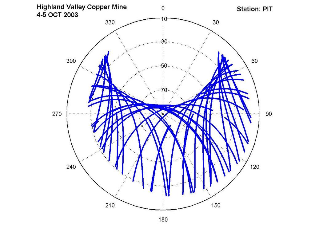
5 DESCRIPTION OF PROBLEM Current deformation monitoring system utilizes robotic total stations (RTS) retroreflecting prisms To reduce pointing errors and atmospheric refraction effects, distances to targets must be within a few hundred metres RTSs located in an unstable environment with a limited visibility 5
6 PROPOSED SOLUTION Combine robotic total stations with GPS to control the stability of the RTS Two requirements: Accuracy of controlling the stability of the RTSs must be within a few millimetres at the 95% confidence level (particularly in height changes), and RTS position corrections must be derived from GPS data in a fully automated mode. 6

7 RTS/GPS STATION 7
8 GPS BIASES AND ERRORS Residual tropospheric delay: Tropospheric delay not accurately predicted by empirical models Possibly the largest remaining error source in dual-frequency precision positioning In the mine, primarily resulting from station height differences Multipath: Specular reflection vs. diffraction and diffusion In an open pit mine, diffraction and diffusion are more common 8
9 UNB APPROACH UNB3 Composite Tropospheric Delay Model Zenith delay algorithms of Saastamoinen Mapping functions of Niell Look-up table of five atmospheric parameters Multipath Mitigation An optimal inter-frequency carrier phase linear combination of the L1 and L2 observations A smoothing process (e.g., sequential least-squares estimation) 9
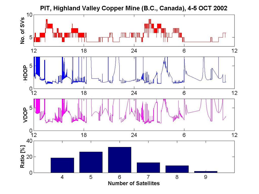
10 INITIAL TEST Experiment early October 2002 Four geodetic performance dual-frequency GPS receivers and antennas (NovAtel OEM4 receivers and GPS-600 pinwheel antennas) Reference station (MAST) setup outside the pit Three monitoring stations (RTS1, RTS2 and PIT) located inside the pit 10
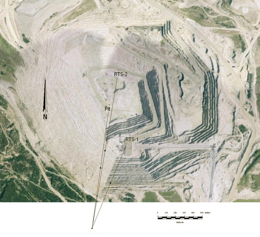
11 11 MAST
12 TEST CONDITIONS Monitoring Stations RTS1-MAST RTS2-MAST PIT-MAST Slant distance (km) Height difference (km)
13 TEST CONDITIONS 13
14 TEST CONDITIONS 14
15 DD TROPOSPHERIC DELAY OBSERVATIONS 15

16 DD MULTIPATH OBSERVATIONS 16
17 HEIGHT SOLUTIONS 17
18 HEIGHT SOLUTIONS CONT D 18
19 CONCLUSIONS Performance of modified UNB RTK software shows promise Still progress to be made to meet requirements Two main issues during the first campaign: No absolute reference to validate results (height solutions of the second day?, height solutions of all three stations commonly affected by some errors?) Geometry of satellites limits achievable precision 19
20 Further Investigation Use of pseudolites to address the issue of limited satellite availability Second campaign: Anomalies (data gaps in observation files, a possible change in position of the MAST station) hinder sound analysis of the current data set Meteorological data to more accurately correlate tropospheric effects with solution variations RTSs used to monitor the stability of the GPS stations 20
21 Ancillary Slides 21
22 Northing Solutions 22
23 Northing Solutions cont d 23
24 Easting Solutions 24
25 Easting Solutions cont d 25
AN INVESTIGATION ON THE USE OF GPS FOR DEFORMATION MONITORING IN OPEN PIT MINES
 1 AN INVESTIGATION ON THE USE OF GPS FOR DEFORMATION MONITORING IN OPEN PIT MINES Jason Bond, Donghyun (Don) Kim, Richard B. Langley and Adam Chrzanowski Department of Geodesy and Geomatics Engineering,
ALERT: A FULLY AUTOMATED REAL TIME MONITORING SYSTEM
 ALERT: A FULLY AUTOMATED REAL TIME MONITORING SYSTEM Rick Wilkins, Geoffrey Bastin, and Adam Chrzanowski Canadian Centre for Geodetic Engineering Dept. of Geodesy & Geomatics Engineering, University of
AN INVESTIGATION ON THE USE OF GPS FOR DEFORMATION MONITORING IN OPEN PIT MINES
 AN INVESTIGATION ON THE USE OF GPS FOR DEFORMATION MONITORING IN OPEN PIT MINES JASON BOND March 2004 TECHNICAL REPORT NO. 222 AN INVESTIGATION ON THE USE OF GPS FOR DEFORMATION MONITORING IN OPEN PIT
Development of a Fully Automated, GPS Based Monitoring System for Disaster Prevention and Emergency Preparedness: PPMS +RT
 Sensors 2007, 7, 1028-1046 sensors ISSN 1424-8220 2007 by MDPI www.mdpi.org/sensors Full Research Paper Development of a Fully Automated, GPS Based Monitoring System for Disaster Prevention and Emergency
GNSS & Coordinate Systems
 GNSS & Coordinate Systems Matthew McAdam, Marcelo Santos University of New Brunswick, Department of Geodesy and Geomatics Engineering, Fredericton, NB May 29, 2012 Santos, 2004 msantos@unb.ca 1 GNSS GNSS
Performance of Long-Baseline Real-Time Kinematic Applications by Improving Tropospheric Delay Modeling
 Performance of Long-Baseline Real-Time Kinematic Applications by Improving Tropospheric Delay Modeling Don Kim 1, Sunil Bisnath 2, Richard B. Langley 1 and Peter Dare 1 1 Geodetic Research Laboratory,
Multipath and Atmospheric Propagation Errors in Offshore Aviation DGPS Positioning
 Multipath and Atmospheric Propagation Errors in Offshore Aviation DGPS Positioning J. Paul Collins, Peter J. Stewart and Richard B. Langley 2nd Workshop on Offshore Aviation Research Centre for Cold Ocean
The CASSIOPE Satellite Ionospheric Profiling Experiment
 The CASSIOPE Satellite Ionospheric Profiling Experiment Richard B. Langley and Don Kim Geodetic Research Laboratory Dept. of Geodesy and Geomatics Engineering University of New Brunswick Fredericton, N.B.
Trimble Business Center:
 Trimble Business Center: Modernized Approaches for GNSS Baseline Processing Trimble s industry-leading software includes a new dedicated processor for static baselines. The software features dynamic selection
Precise Positioning with NovAtel CORRECT Including Performance Analysis
 Precise Positioning with NovAtel CORRECT Including Performance Analysis NovAtel White Paper April 2015 Overview This article provides an overview of the challenges and techniques of precise GNSS positioning.
Interpretation of First Results from the Automated and Integrated Monitoring Scheme at Diamond Valley Lake in California
 Interpretation of First Results from the Automated and Integrated Monitoring Scheme at Diamond Valley Lake Michael A. DUFFY and Cecilia WHITAKER, USA and Adam CHRZANOWSKI and James LUTES, Canada Key words:
Bernese GPS Software 4.2
 Bernese GPS Software 4.2 Introduction Signal Processing Geodetic Use Details of modules Bernese GPS Software 4.2 Highest Accuracy GPS Surveys Research and Education Big Permanent GPS arrays Commercial
 UNBF Researcher Receives Support For Out-Of-This-World Remote Control System -- J... http://www.unb.ca/news/view.cgi?id=567 Page 1 of 1 9/10/2008 UNBF RESEARCHER RECEIVES SUPPORT FOR OUT-OF-THIS-WORLD
Mitigation of GPS Carrier Phase Multipath Effects in Real-Time Kinematic Applications
 Mitigation of GPS Carrier Phase Multipath Effects in Real-Time Kinematic Applications Donghyun Kim and Richard B. Langley Geodetic Research Laboratory, Department of Geodesy and Geomatics Engineering,
Detection and Mitigation of Static Multipath in L1 Carrier Phase Measurements Using a Dual- Antenna Approach
 Detection and Mitigation of Static Multipath in L1 Carrier Phase Measurements Using a Dual- Antenna Approach M.C. Santos Department of Geodesy and Geomatics Engineering, University of New Brunswick, P.O.
Introduction to GNSS Base-Station
 Introduction to GNSS Base-Station Dinesh Manandhar Center for Spatial Information Science The University of Tokyo Contact Information: dinesh@iis.u-tokyo.ac.jp Slide : 1 Introduction GPS or GNSS observation
Modelling GPS Observables for Time Transfer
 Modelling GPS Observables for Time Transfer Marek Ziebart Department of Geomatic Engineering University College London Presentation structure Overview of GPS Time frames in GPS Introduction to GPS observables
 http://www.ion.org/awards/ Congratulations Institute of Navigation Honorees The Annual s Program is sponsored by the Institute of Navigation to recognize individuals making significant contributions,
On Ultrahigh-Precision GPS Positioning and Navigation
 On Ultrahigh-Precision GPS Positioning and Navigation Donghyun Kim and Richard B. Langley Geodetic Research Laboratory, Department of Geodesy and Geomatics Engineering University of New Brunswick, Canada
Integer Ambiguity Resolution for Precise Point Positioning Patrick Henkel
 Integer Ambiguity Resolution for Precise Point Positioning Patrick Henkel Overview Introduction Sequential Best-Integer Equivariant Estimation Multi-frequency code carrier linear combinations Galileo:
ION GNSS 2011 FILLING IN THE GAPS OF RTK WITH REGIONAL PPP
 ION GNSS 2011 FILLING IN THE GAPS OF RTK WITH REGIONAL PPP SEPTEMBER 22 th, 2011 ION GNSS 2011. PORTLAND, OREGON, USA SESSION F3: PRECISE POSITIONING AND RTK FOR CIVIL APPLICATION C. García A. Mozo P.
Impact of Different Tropospheric Models on GPS Baseline Accuracy: Case Study in Thailand
 Journal of Global Positioning Systems (2005) Vol. 4, No. 1-2: 36-40 Impact of Different Tropospheric Models on GPS Baseline Accuracy: Case Study in Thailand Chalermchon Satirapod and Prapod Chalermwattanachai
Qualification of a Commercial Dual Frequency GPS Receiver for the e-pop Platform onboard the Canadian CASSIOPE Spacecraft
 Qualification of a Commercial Dual Frequency GPS Receiver for the e-pop Platform onboard the Canadian CASSIOPE Spacecraft Richard B. Langley (1), Oliver Montenbruck (2) Makus Markgraf (2), Don Kim (1)
Multipath Error Detection Using Different GPS Receiver s Antenna
 Multipath Error Detection Using Different GPS Receiver s Antenna Md. Nor KAMARUDIN and Zulkarnaini MAT AMIN, Malaysia Key words: GPS, Multipath error detection, antenna residual SUMMARY The use of satellite
Assessment of high-rate GPS using a single-axis shake table
 Assessment of high-rate GPS using a single-axis shake table S. Häberling, M. Rothacher, A. Geiger Institute of Geodesy and Photogrammetry, ETH Zurich Introduction Project: Study the applicability of high-rate
THE INFLUENCE OF ZENITH TROPOSPHERIC DELAY ON PPP-RTK. S. Nistor a, *, A.S. Buda a,
 THE INFLUENCE OF ZENITH TROPOSPHERIC DELAY ON PPP-RTK S. Nistor a, *, A.S. Buda a, a University of Oradea, Faculty of Civil Engineering, Cadastre and Architecture, Department Cadastre-Architecture, Romania,
Latest PPP Efforts at UNB ( )
") Latest PPP Efforts at UNB (2007-2008) Simon Banville Rodrigo F. Leandro Hyunho Rho Richard B. Langley Marcelo C. Santos May 27 2008 GEOIDE Annual Conference Niagara Falls, ON, Canada Outline Impact of
Latest PPP Efforts at UNB (2007-2008) Simon Banville Rodrigo F. Leandro Hyunho Rho Richard B. Langley Marcelo C. Santos May 27 2008 GEOIDE Annual Conference Niagara Falls, ON, Canada Outline Impact of
Estimation of the Stochastic Model for Long- Baseline Kinematic GPS Applications
 Estimation of the Stochastic Model for Long- Baseline Kinematic GPS Applications Donghyun Kim and Richard B. Langley Geodetic Research Laboratory, Department of Geodesy and Geomatics Engineering, University
EXPERIMENTAL RESULTS OF LEX CORRECTIONS USING FARMING MACHINE
 Sixth Meeting of the International Committee on Global Navigation Satellite Systems (ICG) EXPERIMENTAL RESULTS OF LEX CORRECTIONS USING FARMING MACHINE Masayuki Kanzaki Hitachi Zosen Corporation Prof.
Assessment of the Accuracy of Processing GPS Static Baselines Up To 40 Km Using Single and Dual Frequency GPS Receivers.
 International OPEN ACCESS Journal Of Modern Engineering Research (IJMER) Assessment of the Accuracy of Processing GPS Static Baselines Up To 40 Km Using Single and Dual Frequency GPS Receivers. Khaled
Multisystem Real Time Precise-Point-Positioning, today with GPS+GLONASS in the near future also with QZSS, Galileo, Compass, IRNSS
 2 International Symposium on /GNSS October 26-28, 2. Multisystem Real Time Precise-Point-Positioning, today with +GLONASS in the near future also with QZSS, Galileo, Compass, IRNSS Álvaro Mozo García,
Monitoring the Ionosphere and Neutral Atmosphere with GPS
 Monitoring the Ionosphere and Neutral Atmosphere with GPS Richard B. Langley Geodetic Research Laboratory Department of Geodesy and Geomatics Engineering University of New Brunswick Fredericton, N.B. Division
A Tropospheric Delay Model for the user of the Wide Area Augmentation System
 A Tropospheric Delay Model for the user of the Wide Area Augmentation System J. Paul Collins and Richard B. Langley 1st October 1996 +641&7%6+1 OBJECTIVES Develop and test a tropospheric propagation delay
Ionospheric Correction and Ambiguity Resolution in DGPS with Single Frequency
 Applied Physics Research November, 9 Ionospheric Correction and Ambiguity Resolution in DGPS with Single Frequency Norsuzila Ya acob Department of Electrical, Electronics and Systems Engineering Universiti
ENGI 3703 Surveying and Geomatics
 Satellite Geometry: Satellites well spread out in the sky have a much stronger solution to the resection type problem (aka trilateration) then satellite that are grouped together. Since the position of
GNSS Modernisation and Its Effect on Surveying. Short range GNSS phase-based positioning is limited by multipath
 3..212 GNSS Modernisation and Its Effect on Surveying Dr. Lawrence Lau Professor Gethin Wyn Roberts FIG Working Week 212 The Motivation Short range GNSS phase-based positioning is limited by multipath
TREATMENT OF DIFFRACTION EFFECTS CAUSED BY MOUNTAIN RIDGES
 TREATMENT OF DIFFRACTION EFFECTS CAUSED BY MOUNTAIN RIDGES Rainer Klostius, Andreas Wieser, Fritz K. Brunner Institute of Engineering Geodesy and Measurement Systems, Graz University of Technology, Steyrergasse
Analyzing GNSS data in precise point positioning software
 DOI 1.17/s1291-1-173-9 REVIEW ARTICLE Analyzing GNSS data in precise point positioning software Rodrigo F. Leandro Marcelo C. Santos Richard B. Langley Received: 25 February 29 / Accepted: 14 May 21 Ó
Comparative analysis of GNSS Real Time Kinematic methods for navigation
 IAV Hassan II Comparative analysis of GNSS Real Time Kinematic methods for navigation Mourad BOUZIANI School of Geomatic Sciences, IAV Hassan II, Rabat, Morocco. Coordinator of the Master - GNSS, IAV&
KALMAN-FILTER-BASED GPS AMBIGUITY RESOLUTION FOR REAL-TIME LONG-BASELINE KINEMATIC APPLICATIONS
 KALMAN-FILTER-BASED GPS AMBIGUITY RESOLUTION FOR REAL-TIME LONG-BASELINE KINEMATIC APPLICATIONS Donghyun Kim and Richard B. Langley Geodetic Research Laboratory, Department of Geodesy and Geomatics Engineering,
Precise Positioning... what does it mean? Precise GNSS Positioning Not just a niche technology. Chris Rizos 15/12/15
 Precise GNSS Positioning Not just a niche technology Chris Rizos Precise Positioning... what does it mean? 1 Precise Positioning... a spectrum of users... Few mm 1cm 2cm < dm 1dm sub-m Precision agriculture
Real-Time Carrier Phase Ambiguity Resolution for GPS/GLONASS Reference Station Networks
 Real-Time Carrier Phase Ambiguity Resolution for GPS/GLONASS Reference Station Networks Liwen Dai, Jinling Wang, Chris Rizos and Shaowei Han School of Geomatic Engineering University of New South Wales
Determination of refractivity variations with GNSS and ultra-stable frequency standards
 Determination of refractivity variations with GNSS and ultra-stable frequency standards Markus Vennebusch, Steffen Schön, Ulrich Weinbach Institut für Erdmessung (IfE) / Institute of Geodesy Leibniz-Universität
Errors in GPS. Errors in GPS. Geodetic Co-ordinate system. R. Khosla Fall Semester
 Errors in GPS Errors in GPS GPS is currently the most accurate positioning system available globally. Although we are talking about extreme precision and measuring distances by speed of light, yet there
MODIFIED GPS-OTF ALGORITHMS FOR BRIDGE MONITORING: APPLICATION TO THE PIERRE-LAPORTE SUSPENSION BRIDGE IN QUEBEC CITY
 MODIFIED GPS-OTF ALGORITHMS FOR BRIDGE MOITORIG: APPLICATIO TO THE PIERRE-LAPORTE SUSPESIO BRIDGE I QUEBEC CIT Rock Santerre and Luc Lamoureux Centre de Recherche en Géomatique Université Laval Québec,
Reduction of Pseudorange Multipath Error in Static Positioning. Tokyo University of Mercantile Marine Nobuaki Kubo Akio Yasuda
 Reduction of Pseudorange Multipath Error in Static Positioning Tokyo University of Mercantile Marine Nobuaki Kubo Akio Yasuda Brief Many researchers have tried to reduce the multipath effect from both
Assessment of WAAS Correction Data in Eastern Canada
 Abstract Assessment of WAAS Correction Data in Eastern Canada Hyunho Rho and Richard B. Langley Geodetic Research Laboratory University of New Brunswick P.O. Box Fredericton, NB Canada, E3B 5A3 As part
One Source for Positioning Success
 novatel.com One Source for Positioning Success RTK, PPP, SBAS OR DGNSS. NOVATEL CORRECT OPTIMIZES ALL CORRECTION SOURCES, PUTTING MORE POWER, FLEXIBILITY AND CONTROL IN YOUR HANDS. NovAtel CORRECT is the
GNSS Reflectometry: Innovative Remote Sensing
 GNSS Reflectometry: Innovative Remote Sensing J. Beckheinrich 1, G. Beyerle 1, S. Schön 2, H. Apel 1, M. Semmling 1, J. Wickert 1 1.GFZ, German Research Center for Geosciences, Potsdam, Germany 2.Leibniz
Foreword by Glen Gibbons About this book Acknowledgments List of abbreviations and acronyms List of definitions
 Table of Foreword by Glen Gibbons About this book Acknowledgments List of abbreviations and acronyms List of definitions page xiii xix xx xxi xxv Part I GNSS: orbits, signals, and methods 1 GNSS ground
Estimating Zenith Total Delay Fields by using Ground-Based GPS network
 Estimating Zenith Total Delay Fields by using Ground-Based GPS network R. Pacione, B. Pace, C. Sciarretta e-geos S.p.A. CGS - Matera, Italy F. Vespe Agenzia Spaziale Italiana, CGS - Matera, Italy Outlook
Introduction to DGNSS
 Introduction to DGNSS Jaume Sanz Subirana J. Miguel Juan Zornoza Research group of Astronomy & Geomatics (gage) Technical University of Catalunya (UPC), Spain. Web site: http://www.gage.upc.edu Hanoi,
Ionospheric Disturbance Indices for RTK and Network RTK Positioning
 Ionospheric Disturbance Indices for RTK and Network RTK Positioning Lambert Wanninger Geodetic Institute, Dresden University of Technology, Germany BIOGRAPHY Lambert Wanninger received his Dipl.-Ing. and
Space Weather influence on satellite based navigation and precise positioning
 Space Weather influence on satellite based navigation and precise positioning R. Warnant, S. Lejeune, M. Bavier Royal Observatory of Belgium Avenue Circulaire, 3 B-1180 Brussels (Belgium) What this talk
Locata: A New Constellation for High Accuracy Outdoor & Indoor Positioning
 Locata: A New Constellation for High Accuracy Outdoor & Indoor Positioning Chris Rizos, Yong Li, Nonie Politi School of Surveying & Spatial Information Systems University of New South Wales, Sydney, Australia
Global Products for GPS Point Positioning Approaching Real-Time
 Global Products for GPS Point Positioning Approaching Real-Time Y. Gao 1, P. Heroux 2 and M. Caissy 2 1 Department of Geomatics Engineering, University of Calgary 2 Geodetic Survey Division, Natural Resources
International Journal of Scientific & Engineering Research, Volume 7, Issue 12, December-2016
 International Journal of Scientific & Engineering Research, Volume 7, Issue 2, December-26 642 Enhancement of Precise Point Positioning Using GPS Single Frequency Data Ibrahim F. Shaker*, Tamer F. Fath-Allah**,
THE MONITORING OF BRIDGE MOVEMENTS USING GPS AND PSEUDOLITES
 Proceedings, 11 th FIG Symposium on Deformation Measurements, Santorini, Greece, 23. THE MONITORING OF BRIDGE MOVEMENTS USING GPS AND PSEUDOLITES Joel Barnes 1, Chris Rizos 1, Jinling Wang 1 Xiaolin Meng
Toward the Ultimate RTK: The Last Challenges in Long-Range Real-Time Kinematic Applications
 Toard the Ultimate RTK: The Last Challenges in Long-Range Real-Time Kinematic Applications Don Kim and Richard B. Langley Geodetic Research Laboratory, Department of Geodesy and Geomatics Engineering University
REAL-TIME GPS ATTITUDE DETERMINATION SYSTEM BASED ON EPOCH-BY-EPOCH TECHNOLOGY
 REAL-TIME GPS ATTITUDE DETERMINATION SYSTEM BASED ON EPOCH-BY-EPOCH TECHNOLOGY Dr. Yehuda Bock 1, Thomas J. Macdonald 2, John H. Merts 3, William H. Spires III 3, Dr. Lydia Bock 1, Dr. Jeffrey A. Fayman
Monitoring the Auroral Oval with GPS and Applications to WAAS
 Monitoring the Auroral Oval with GPS and Applications to WAAS Peter J. Stewart and Richard B. Langley Geodetic Research Laboratory Department of Geodesy and Geomatics Engineering University of New Brunswick
GNSS Technologies. PPP and RTK
 PPP and RTK 29.02.2016 Content Carrier phase based positioning PPP RTK VRS Slides based on: GNSS Applications and Methods, by S. Gleason and D. Gebre-Egziabher (Eds.), Artech House Inc., 2009 http://www.gnssapplications.org/
Using High-rate GPS Data to Monitor the Dynamic Behavior of a Cable-stayed Bridge
 Using High-rate GPS Data to Monitor the Dynamic Behavior of a Cable-stayed Bridge Ana Paula C. Larocca Sao Carlos Engineering School University of Sao Paulo BIOGRAPHY Ana Paula Camargo Larocca received
RTCM State Space Representation (SSR) Overall Concepts Towards PPP-RTK
 Overall Concepts Towards PPP-RTK") RTCM State Space Representation (SSR) Overall Concepts Towards PPP-RTK Gerhard Wübbena Geo++ GmbH 30827 Garbsen Germany www.geopp.de Contents Terms and Abbreviations RTCM-SSR Working Group GNSS Error Sources
RTCM State Space Representation (SSR) Overall Concepts Towards PPP-RTK Gerhard Wübbena Geo++ GmbH 30827 Garbsen Germany www.geopp.de Contents Terms and Abbreviations RTCM-SSR Working Group GNSS Error Sources
Data Acquisition Experiment using NovAtel Dual Frequency GPS Receiver
 Data Acquisition Experiment using NovAtel Dual Frequency GPS Receiver Dhiraj Sunehra Jawaharlal Nehru Technological University Hyderabad, Andhra Pradesh, India Abstract The advent of very large scale integration
SUPPORT OF NETWORK FORMATS BY TRIMBLE GPSNET NETWORK RTK SOLUTION
 SUPPORT OF NETWORK FORMATS BY TRIMBLE GPSNET NETWORK RTK SOLUTION TRIMBLE TERRASAT GMBH, HARINGSTRASSE 19, 85635 HOEHENKIRCHEN, GERMANY STATUS The Trimble GPSNet network RTK solution was first introduced
CONVERGENCE TIME IMPROVEMENT OF PRECISE POINT POSITIONING
 CONVERGENCE TIME IMPROVEMENT OF PRECISE POINT POSITIONING Mohamed Elsobeiey and Ahmed El-Rabbany Department of Civil Engineering (Geomatics Option) Ryerson University, CANADA Outline Introduction Impact
Pseudolites and their Applications
 269 Pseudolites and their Applications Cellmer, S., Rapi ski, J. and Rzepecka, Z. Institute of Geodesy, University of Warmia and Mazury in Olsztyn, Poland E-mail: jacek.rapinski@gmail.com Abstract For
Sidereal Filtering Based on GPS Single Differences for Mitigating Multipath Effects
 International Global Navigation Satellite Systems Society IGNSS Symposium 2007 The University of New South Wales, Sydney, ustralia 4 6 December, 2007 Sidereal Filtering Based on GPS Single Differences
Exploiting AFSCN Ranging Data for Catalog Maintenance
 Exploiting AFSCN Ranging Data for Catalog Maintenance A. J. Coster, R. Abbot, L. E. Thornton, D. Durand 2001 Space Control Conference 3 April 2001 4.03.01-1 This work is sponsored by the Air Force under
Procedures for Quality Control of GNSS Surveying Results Based on Network RTK Corrections.
 Procedures for Quality Control of GNSS Surveying Results Based on Network RTK Corrections. Limin WU, China Feng xia LI, China Joël VAN CRANENBROECK, Switzerland Key words : GNSS Rover RTK operations, GNSS
WHITE PAPER ABSTARCT. The new Quantum TM Algorithm by ComNav Technology July 2016
 WHITE PAPER The new Quantum TM Algorithm by ComNav Technology July 206 ABSTARCT The latest Quantum TM algorithm, as an upgrade of ComNav Technology Quan tm Algorithm, is a brand new technology that improves
New Tools for Network RTK Integrity Monitoring
 New Tools for Network RTK Integrity Monitoring Xiaoming Chen, Herbert Landau, Ulrich Vollath Trimble Terrasat GmbH BIOGRAPHY Dr. Xiaoming Chen is a software engineer at Trimble Terrasat. He holds a PhD
Estimating Zenith Total Delay Residual Fields by using Ground-Based GPS network. Presented at EUREF Symposium 2010 Gävle,
 Estimating Zenith Total Delay Residual Fields by using Ground-Based GPS network B. PACE, R. PACIONE, C. SCIARRETTA, F. VESPE 2 e-geos, Centro di Geodesia Spaziale, 7500 Matera Italy 2 Agenzia Spaziale
Pseudorange Multipath Mitigation By Means of Multipath Monitoring and De-Weighting
 Pseudorange Multipath Mitigation By Means of Multipath Monitoring and De-Weighting Sunil B. Bisnath and Richard B. Langley Geodetic Research Laboratory, Department of Geodesy and Geomatics Engineering,
Geodetic Reference via Precise Point Positioning - RTK
 2012 Geo++ GmbH Geodetic Reference via Precise Point Positioning - RTK Gerhard Wübbena Geo++ GmbH 30827 Garbsen Germany www.geopp.de 2012 Geo++ GmbH Contents Terms and Abbreviations GNSS Principles GNSS
AUSPOS GPS Processing Report
 AUSPOS GPS Processing Report February 13, 2012 This document is a report of the GPS data processing undertaken by the AUSPOS Online GPS Processing Service (version: AUSPOS 2.02). The AUSPOS Online GPS
Improving Real-Time Kinematic PPP with Instantaneous Cycle-Slip Correction
 Improving Real-Time Kinematic PPP with Instantaneous Cycle-Slip Correction Simon Banville and Richard B. Langley, University of New Brunswick, Canada BIOGRAPHY Simon Banville is a Ph.D. candidate in the
FieldGenius Technical Notes GPS Terminology
 FieldGenius Technical Notes GPS Terminology Almanac A set of Keplerian orbital parameters which allow the satellite positions to be predicted into the future. Ambiguity An integer value of the number of
Accuracy Assessment of GPS Slant-Path Determinations
 Accuracy Assessment of GPS Slant-Path Determinations Pedro ELOSEGUI * and James DAVIS Harvard-Smithsonian Center for Astrophysics, Cambridge, MA, USA Abtract We have assessed the accuracy of GPS for determining
Low-cost densification of permanent GPS networks for natural hazard mitigation: First tests on GSI s GEONET network
 LETTER Earth Planets Space, 52, 867 871, 2000 Low-cost densification of permanent GPS networks for natural hazard mitigation: First tests on GSI s GEONET network Chris Rizos 1, Shaowei Han 1, Linlin Ge
Investigation on the Impact of Tropospheric Delay on GPS Height Variation near the Equator
 Investigation on the Impact of Tropospheric Delay on GPS Height Variation near the Equator Abstract One of the major problems currently facing satellite-based positioning is the atmospheric refraction
Integrity of Satellite Navigation in the Arctic
 Integrity of Satellite Navigation in the Arctic TODD WALTER & TYLER REID STANFORD UNIVERSITY APRIL 2018 Satellite Based Augmentation Systems (SBAS) in 2018 2 SBAS Networks in 2021? 3 What is Meant by Integrity?
Development and assessment of a medium-range real-time kinematic GPS algorithm using an ionospheric information filter
 LETTER Earth Planets Space, 52, 783 788, 2000 Development and assessment of a medium-range real-time kinematic GPS algorithm using an ionospheric information filter Ming Yang 1, Chin-Hsien Tang 1, and
1998: A YEAR OF INNOVATION IN (THE)
") 1998: A YEAR OF INNOVATION IN (THE) Richard B. Langley Geodetic Research Laboratory University of New Brunswick Invited presentation at the Association of New Brunswick Land Surveyors Annual General Meeting,
1998: A YEAR OF INNOVATION IN (THE) Richard B. Langley Geodetic Research Laboratory University of New Brunswick Invited presentation at the Association of New Brunswick Land Surveyors Annual General Meeting,
Advances in GNSS-RTK for Structural Deformation Monitoring in Regions of High Ionospheric Activity
 Advances in GNSS-RTK for Structural Deformation Monitoring in Regions of High Ionospheric Activity Chris RIZOS, Australia, Joël van CRANENBROECK, Belgium, Vincent LUI, Hong Kong, PR China Key words: GNSS,
How multipath error influences on ambiguity resolution
 How multipath error influences on ambiguity resolution Nobuaki Kubo, Akio Yasuda Tokyo University of Mercantile Marine BIOGRAPHY Nobuaki Kubo received his Master of Engineering (Electrical) in 99 from
Improved Ambiguity Resolution by an Equatorial Ionospheric Differential Correction for Precise Positioning
 Improved Ambiguity Resolution by an Equatorial Ionospheric Differential Correction for Precise Positioning NORSUZILA YA ACOB 1, MARDINA ABDULLAH,* MAHAMOD ISMAIL,* AND AZAMI ZAHARIM 3,** 1 Faculty of Electrical
Local GPS tropospheric tomography
 LETTER Earth Planets Space, 52, 935 939, 2000 Local GPS tropospheric tomography Kazuro Hirahara Graduate School of Sciences, Nagoya University, Nagoya 464-8602, Japan (Received December 31, 1999; Revised
Ultra-wideband Radio Aided Carrier Phase Ambiguity Resolution in Real-Time Kinematic GPS Relative Positioning
 Ultra-wideband Radio Aided Carrier Phase Ambiguity Resolution in Real-Time Kinematic GPS Relative Positioning Eric Broshears, Scott Martin and Dr. David Bevly, Auburn University Biography Eric Broshears
Effect of Quasi Zenith Satellite (QZS) on GPS Positioning
 on GPS Positioning") Effect of Quasi Zenith Satellite (QZS) on GPS ing Tomoji Takasu 1, Takuji Ebinuma 2, and Akio Yasuda 3 Laboratory of Satellite Navigation, Tokyo University of Marine Science and Technology 1 (Tel: +81-5245-7365,
Effect of Quasi Zenith Satellite (QZS) on GPS ing Tomoji Takasu 1, Takuji Ebinuma 2, and Akio Yasuda 3 Laboratory of Satellite Navigation, Tokyo University of Marine Science and Technology 1 (Tel: +81-5245-7365,
Global Navigation Satellite System (GNSS) for Disaster Mitigation
 for Disaster Mitigation") Global Navigation Satellite System (GNSS) for Disaster Mitigation By Chathura H. Wickramasinghe Geoinformatics Center Asian Institute of Technology Establish in 1959 as a Post Graduate School Catering
Global Navigation Satellite System (GNSS) for Disaster Mitigation By Chathura H. Wickramasinghe Geoinformatics Center Asian Institute of Technology Establish in 1959 as a Post Graduate School Catering
COMPARISON OF RELATIVE AND ABSOLUTE PRECISION OF OHIO S WIDE AREA GPS NETWORK INCLUDING THE COMPARISON WITH ALTERNATIVE METHODS.
 COMPARISON OF RELATIVE AND ABSOLUTE PRECISION OF OHIO S WIDE AREA GPS NETWORK INCLUDING THE COMPARISON WITH ALTERNATIVE METHODS A Thesis Presented in Partial Fulfillment of the Requirements for the Degree
The impact of tropospheric mapping functions based on numerical weather models on the determination of geodetic parameters
 The impact of tropospheric mapping functions based on numerical weather models on the determination of geodetic parameters J. Boehm, P.J. Mendes Cerveira, H. Schuh Institute of Geodesy and Geophysics,
Performance Evaluation of Multiple Reference Station GPS RTK for a Medium Scale Network
 Journal of Global Positioning Systems (2004) Vol. 3, No. 12: 173182 Performance Evaluation of Multiple Reference Station GPS RTK for a Medium Scale Network T.H. Diep Dao, Paul Alves and Gérard Lachapelle
LOCAL IONOSPHERIC MODELLING OF GPS CODE AND CARRIER PHASE OBSERVATIONS
 Survey Review, 40, 309 pp.71-84 (July 008) LOCAL IONOSPHERIC MODELLING OF GPS CODE AND CARRIER PHASE OBSERVATIONS H. Nahavandchi and A. Soltanpour Norwegian University of Science and Technology, Division
Atmospheric Delay Reduction Using KARAT for GPS Analysis and Implications for VLBI
 Atmospheric Delay Reduction Using KARAT for GPS Analysis and Implications for VLBI ICHIKAWA Ryuichi 2, Thomas HOBIGER 1, KOYAMA Yasuhiro 1, KONDO Tetsuro 2 1) Kashima Space Research Center, National Institute
Instantaneous Real-time Cycle-slip Correction of Dual-frequency GPS Data
 Instantaneous Real-time Cycle-slip Correction of Dual-frequency GPS Data Donghyun Kim and Richard B. Langley Geodetic Research Laboratory, Department of Geodesy and Geomatics Engineering, University of
FAST PRECISE GPS POSITIONING IN THE PRESENCE OF IONOSPHERIC DELAYS
 FAST PRECISE GPS POSITIONING IN THE PRESENCE OF IONOSPHERIC DELAYS Proefschrift ter verkrijging van de graad van doctor aan de Technische Universiteit Delft, op gezag van de Rector Magnificus prof.dr.ir.
Analysis of GNSS Receiver Biases and Noise using Zero Baseline Techniques
 1 Analysis of GNSS Receiver Biases and Noise using Zero Baseline Techniques Ken MacLeod, Simon Banville, Reza Ghoddousi-Fard and Paul Collins Canadian Geodetic Survey, Natural Resources Canada Plenary