3D-Map Aided Multipath Mitigation for Urban GNSS Positioning
|
|
|
- Alicia Scott
- 6 years ago
- Views:
Transcription
1 Summer School on GNSS 2014 Student Scholarship Award Workshop August 2, D-Map Aided Multipath Mitigation for Urban GNSS Positioning I-Wen Chu National Cheng Kung University, Taiwan. Page 1
2 Outline Introduction Related Works Flow Chart Multipath Effect Correlation Function Discriminator Output Implementation Ray-tracing Establishment of Multipath-induced Delay Database Simulation Result Correction of the Position Solution Gratitude Page 2


3 Introduction Direct signal Global navigation satellite system has been widely used in the personal and vehicular positioning for safety and convenience purposes. GNSS positioning error sources Ionospheric error Tropospheric error Clock and ephemeris error Receiver noise Multipath effect Relatively more difficult to be detected and predicted Especially in urban environment, the multipath effect is a critical issue. Degrading positioning accuracy Preventing the receiver from locking signal Reflected signal Page 3


4 Introduction Recently, with the arrival of 3D map information, it can be used to enhance the satellite positioning performance since multipath effect is an environment-dependent issue. We would like to mitigate multipath effect by applying the ray-tracing technique to obtain a database about the relation between the multipath-induced delay and the distance from the receiver to the building, and under the assistance of 3D map to correct the position solution. Page 4
5 Related Works A variety of approaches have already been proposed in order to detect and mitigate multipath effects on GNSS positioning. Improvement of receiver hardware Algorithmic method Correlator technique Estimation technique Using antenna arrays to distinguish multipath signals Using additional sensors such as an infrared camera to detect whether the direct signal is blocked and then exclude the pseudorange measurements of the invisible satellites Using Receiver Autonomous Integrity Monitoring (RAIM) algorithm to provide an alert by assessing GNSS measurement residuals Narrow correlator technique Strobe correlator technique Multi-correlator architecture Utilizing multipath estimating delay locked loop (MEDLL) to estimate each parameter of multipath signals Page 5

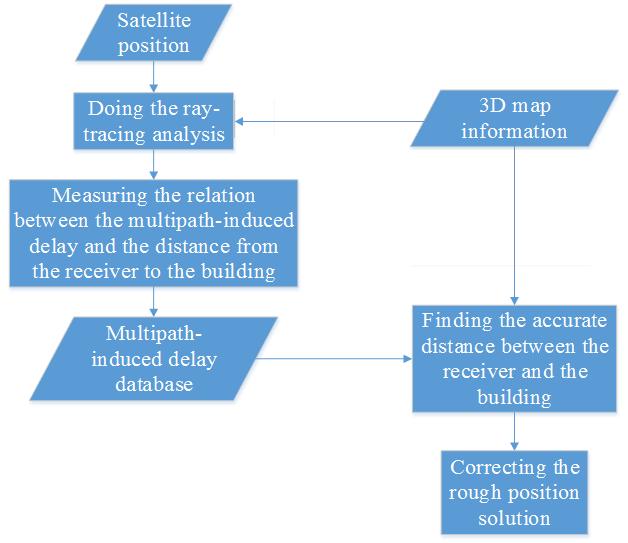
6 Flow Chart Page 6
7 Multipath Effect GNSS positioning is based on the time-of-flight principle. Generally, at least four measurements are needed to solve the threedimensional position solution and the receiver time offset. The raw measurement namely pseudorange is the speed of light multiplied by the time shift required for a replica generated by local code generator to correlate with the code transmitted from the satellite. A mathematical model of multipath signal is modeled as M cos s t ai t C t i t t i t i0 Since multipath signal takes longer distance to travel compared with direct signal, it is more prone to signal delay and power attenuation. Reflected signal Direct signal Page 7
8 Correlation Function Compared with direct line-of-sight signal, the reflected signal is delayed and attenuated. Multipath effect on correlation function: In the presence of multipath signal, the resultant correlation function is distorted. Page 8
9 Discriminator Output A discriminator is used in the code tracking loop to provide an error signal so that the local replica can be aligned to the incoming code. Multipath effect on discriminator output result: Multipath-induced delay Multipath leads to a shift, so called multipath-induced delay, of the zerocrossover point in the discriminator output S-curve. Consequently, the pseudorange error is resulted in. Page 9
10 Ray-tracing Ray-tracing technique is applied to obtain the reflecting point and the path difference between the direct signal and the reflected signal. From the ephemeris data, the position of the satellite is calculated in order to determine the elevation and azimuth angles of the satellite seen from the receiver. According to optics and geometry theories, the reflecting point on the reflecting surface is computed. As a result, the path difference between the direct signal and the reflected signal is estimated; so is the propagating time delay caused by the environment. s 1 s 0 s 1 -s 0 = path difference Page 10
11 Establishment of Multipath-induced Delay Database Having the path difference information, the multipath-induced phase error and multipath-induced delay can be estimated based on the concepts of correlation function and discriminator output. Through simulation, the relation between the multipath-induced delay and the distance from the receiver to the building is measured and observed. The multipath-induced delay database is represented as ε=f(θ, φ, d) where ε is the multipath-induced delay θ is the elevation angle of the satellite φ is the azimuth angle of the satellite d is the distance between the receiver and the building d Page 11
12 Simulation Result The variation of the path difference between the direct signal and the reflected signal: Page 12
13 Simulation Result The variation of the multipath-induced delay by using the correlator spacing of 1 chip: Distance between the receiver and the building from 0(km) to 0.05(km) Distance between the receiver and the building from 0.3(km) to 0.36(km) Page 13
14 Simulation Result The variation of the multipath-induced delay under three different correlator spacing circumstances: Using smaller correlator spacing in the code tracking loop can improve the positioning accuracy. Page 14
15 Correction of the Position Solution In the positioning process of the receiver, the composite effect of multipath signals can be obtained, that is to say, the multipath-induced delay is known. With 3D map information, the surrounding environment of the receiver can be realized. Multipathinduced delay 3D map information Contrasted with the data in database Elevation and azimuth angles of the satellite From the ephemeris data, the satellite positions can be calculated. Accurate distance between the receiver and the building Page 15

16 Correction of the Position Solution Through the multipath-induced delay versus distance between the receiver and the building diagram, we can get a set of corresponding distances for a given multipath-induced delay and satellite position. For a different satellite which generates multipath signals, we can get a different set of corresponding distances. Finding the intersection of these sets, we can obtain the accurate distance between the receiver and the building. As a result, the position solution can be corrected and the positioning accuracy can then be improved. Page 16

17 Gratitude Clear and detailed lectures Useful practices and interesting demos Friendly participants and kind teachers Especially my group members!!! Page 17


18 Page 18
Assessing & Mitigation of risks on railways operational scenarios
 R H I N O S Railway High Integrity Navigation Overlay System Assessing & Mitigation of risks on railways operational scenarios Rome, June 22 nd 2017 Anja Grosch, Ilaria Martini, Omar Garcia Crespillo (DLR)
It is well known that GNSS signals
 GNSS Solutions: Multipath vs. NLOS signals GNSS Solutions is a regular column featuring questions and answers about technical aspects of GNSS. Readers are invited to send their questions to the columnist,
MULTIPATH EFFECT MITIGATION IN SIGNAL PROPAGATION THROUGH AN INDOOR ENVIRONMENT
 JOURNAL OF APPLIED ENGINEERING SCIENCES VOL. 2(15), issue 2_2012 ISSN 2247-3769 ISSN-L 2247-3769 (Print) / e-issn:2284-7197 MULTIPATH EFFECT MITIGATION IN SIGNAL PROPAGATION THROUGH AN INDOOR ENVIRONMENT
Global Navigation Satellite Systems (GNSS)Part I EE 570: Location and Navigation
Part I EE 570: Location and Navigation") Lecture Global Navigation Satellite Systems (GNSS)Part I EE 570: Location and Navigation Lecture Notes Update on April 25, 2016 Aly El-Osery and Kevin Wedeward, Electrical Engineering Dept., New Mexico
Lecture Global Navigation Satellite Systems (GNSS)Part I EE 570: Location and Navigation Lecture Notes Update on April 25, 2016 Aly El-Osery and Kevin Wedeward, Electrical Engineering Dept., New Mexico
Multipath and Atmospheric Propagation Errors in Offshore Aviation DGPS Positioning
 Multipath and Atmospheric Propagation Errors in Offshore Aviation DGPS Positioning J. Paul Collins, Peter J. Stewart and Richard B. Langley 2nd Workshop on Offshore Aviation Research Centre for Cold Ocean
UNIT 1 - introduction to GPS
 UNIT 1 - introduction to GPS 1. GPS SIGNAL Each GPS satellite transmit two signal for positioning purposes: L1 signal (carrier frequency of 1,575.42 MHz). Modulated onto the L1 carrier are two pseudorandom
Modelling GPS Observables for Time Transfer
 Modelling GPS Observables for Time Transfer Marek Ziebart Department of Geomatic Engineering University College London Presentation structure Overview of GPS Time frames in GPS Introduction to GPS observables
Global Navigation Satellite Systems II
 Global Navigation Satellite Systems II AERO4701 Space Engineering 3 Week 4 Last Week Examined the problem of satellite coverage and constellation design Looked at the GPS satellite constellation Overview
EE 570: Location and Navigation
 EE 570: Location and Navigation Global Navigation Satellite Systems (GNSS) Part I Aly El-Osery Kevin Wedeward Electrical Engineering Department, New Mexico Tech Socorro, New Mexico, USA In Collaboration
FieldGenius Technical Notes GPS Terminology
 FieldGenius Technical Notes GPS Terminology Almanac A set of Keplerian orbital parameters which allow the satellite positions to be predicted into the future. Ambiguity An integer value of the number of
Trustworthy Positioning for Next Generation Intelligent Transport Systems Ahmed El-Mowafy
 Trustworthy Positioning for Next Generation Intelligent Transport Systems Ahmed El-Mowafy Contents Background on ITS and C-ITS Requirements Challenges RAIM Test and Results Utilisation Workshop, Sydney,
The Influence of Multipath on the Positioning Error
 The Influence of Multipath on the Positioning Error Andreas Lehner German Aerospace Center Münchnerstraße 20 D-82230 Weßling, Germany andreas.lehner@dlr.de Co-Authors: Alexander Steingaß, German Aerospace
Measuring Galileo s Channel the Pedestrian Satellite Channel
 Satellite Navigation Systems: Policy, Commercial and Technical Interaction 1 Measuring Galileo s Channel the Pedestrian Satellite Channel A. Lehner, A. Steingass, German Aerospace Center, Münchnerstrasse
Research Article A Ray-Tracing Technique to Characterize GPS Multipath in the Frequency Domain
 International Journal of Navigation and Observation Volume 215, Article ID 983124, 16 pages http://dx.doi.org/1.1155/215/983124 Research Article A Ray-Tracing Technique to Characterize GPS Multipath in
HIGH GAIN ADVANCED GPS RECEIVER
 ABSTRACT HIGH GAIN ADVANCED GPS RECEIVER NAVSYS High Gain Advanced () uses a digital beam-steering antenna array to enable up to eight GPS satellites to be tracked, each with up to dbi of additional antenna
ESTIMATION OF IONOSPHERIC DELAY FOR SINGLE AND DUAL FREQUENCY GPS RECEIVERS: A COMPARISON
 ESTMATON OF ONOSPHERC DELAY FOR SNGLE AND DUAL FREQUENCY GPS RECEVERS: A COMPARSON K. Durga Rao, Dr. V B S Srilatha ndira Dutt Dept. of ECE, GTAM UNVERSTY Abstract: Global Positioning System is the emerging
Signals, and Receivers
 ENGINEERING SATELLITE-BASED NAVIGATION AND TIMING Global Navigation Satellite Systems, Signals, and Receivers John W. Betz IEEE IEEE PRESS Wiley CONTENTS Preface Acknowledgments Useful Constants List of
AIRPORT MULTIPATH SIMULATION AND MEASUREMENT TOOL FOR SITING DGPS REFERENCE STATIONS
 AIRPORT MULTIPATH SIMULATION AND MEASUREMENT TOOL FOR SITING DGPS REFERENCE STATIONS ABSTRACT Christophe MACABIAU, Benoît ROTURIER CNS Research Laboratory of the ENAC, ENAC, 7 avenue Edouard Belin, BP
Prototype Software-based Receiver for Remote Sensing using Reflected GPS Signals. Dinesh Manandhar The University of Tokyo
 Prototype Software-based Receiver for Remote Sensing using Reflected GPS Signals Dinesh Manandhar The University of Tokyo dinesh@qzss.org 1 Contents Background Remote Sensing Capability System Architecture
Satellite-Induced Multipath Analysis on the Cause of BeiDou Code Pseudorange Bias
 Satellite-Induced Multipath Analysis on the Cause of BeiDou Code Pseudorange Bias Hailong Xu, Xiaowei Cui and Mingquan Lu Abstract Data from previous observation have shown that the BeiDou satellite navigation
TEST RESULTS OF A HIGH GAIN ADVANCED GPS RECEIVER
 TEST RESULTS OF A HIGH GAIN ADVANCED GPS RECEIVER ABSTRACT Dr. Alison Brown, Randy Silva, Gengsheng Zhang,; NAVSYS Corporation. NAVSYS High Gain Advanced GPS Receiver () uses a digital beam-steering antenna
Effect of Quasi Zenith Satellite (QZS) on GPS Positioning
 on GPS Positioning") Effect of Quasi Zenith Satellite (QZS) on GPS ing Tomoji Takasu 1, Takuji Ebinuma 2, and Akio Yasuda 3 Laboratory of Satellite Navigation, Tokyo University of Marine Science and Technology 1 (Tel: +81-5245-7365,
Effect of Quasi Zenith Satellite (QZS) on GPS ing Tomoji Takasu 1, Takuji Ebinuma 2, and Akio Yasuda 3 Laboratory of Satellite Navigation, Tokyo University of Marine Science and Technology 1 (Tel: +81-5245-7365,
Indoor Positioning by the Fusion of Wireless Metrics and Sensors
 Indoor Positioning by the Fusion of Wireless Metrics and Sensors Asst. Prof. Dr. Özgür TAMER Dokuz Eylül University Electrical and Electronics Eng. Dept Indoor Positioning Indoor positioning systems (IPS)
Phase Center Calibration and Multipath Test Results of a Digital Beam-Steered Antenna Array
 Phase Center Calibration and Multipath Test Results of a Digital Beam-Steered Antenna Array Kees Stolk and Alison Brown, NAVSYS Corporation BIOGRAPHY Kees Stolk is an engineer at NAVSYS Corporation working
We Know Where You Are : Indoor WiFi Localization Using Neural Networks Tong Mu, Tori Fujinami, Saleil Bhat
 We Know Where You Are : Indoor WiFi Localization Using Neural Networks Tong Mu, Tori Fujinami, Saleil Bhat Abstract: In this project, a neural network was trained to predict the location of a WiFi transmitter
Performance Evaluation of Global Differential GPS (GDGPS) for Single Frequency C/A Code Receivers
 for Single Frequency C/A Code Receivers") Performance Evaluation of Global Differential GPS (GDGPS) for Single Frequency C/A Code Receivers Sundar Raman, SiRF Technology, Inc. Lionel Garin, SiRF Technology, Inc. BIOGRAPHY Sundar Raman holds a
Performance Evaluation of Global Differential GPS (GDGPS) for Single Frequency C/A Code Receivers Sundar Raman, SiRF Technology, Inc. Lionel Garin, SiRF Technology, Inc. BIOGRAPHY Sundar Raman holds a
Analysis of Multiple GPS Antennas for Multipath Mitigation in Vehicular Navigation
 Analysis of Multiple GPS s for Multipath Mitigation in Vehicular Navigation R. A. Nayak, M. E. Cannon Department of Geomatics Engineering University of Calgary, Calgary C. Wilson, G. Zhang DaimlerChrysler
Global Correction Services for GNSS
 Global Correction Services for GNSS Hemisphere GNSS Whitepaper September 5, 2015 Overview Since the early days of GPS, new industries emerged while existing industries evolved to use position data in real-time.
Comparative analysis of the effect of ionospheric delay on user position accuracy using single and dual frequency GPS receivers over Indian region
 Indian Journal of Radio & Space Physics Vol. 38, February 2009, pp. 57-61 Comparative analysis of the effect of ionospheric delay on user position accuracy using single and dual frequency GPS receivers
Foreword by Glen Gibbons About this book Acknowledgments List of abbreviations and acronyms List of definitions
 Table of Foreword by Glen Gibbons About this book Acknowledgments List of abbreviations and acronyms List of definitions page xiii xix xx xxi xxv Part I GNSS: orbits, signals, and methods 1 GNSS ground
Demonstrations of Multi-Constellation Advanced RAIM for Vertical Guidance using GPS and GLONASS Signals
 Demonstrations of Multi-Constellation Advanced RAIM for Vertical Guidance using GPS and GLONASS Signals Myungjun Choi, Juan Blanch, Stanford University Dennis Akos, University of Colorado Boulder Liang
Utilizing Batch Processing for GNSS Signal Tracking
 Utilizing Batch Processing for GNSS Signal Tracking Andrey Soloviev Avionics Engineering Center, Ohio University Presented to: ION Alberta Section, Calgary, Canada February 27, 2007 Motivation: Outline
Research Article NLOS Signal Detection Based on Single Orthogonal Dual-Polarized GNSS Antenna
 Hindawi International Journal of Antennas and Propagation Volume 27, Article ID 8548427, pages https://doi.org/.55/27/8548427 Research Article N Signal Detection Based on Single Orthogonal Dual-Polarized
ARAIM Fault Detection and Exclusion
 ARAIM Fault Detection and Exclusion Boris Pervan Illinois Institute of Technology Chicago, IL November 16, 2017 1 RAIM ARAIM Receiver Autonomous Integrity Monitoring (RAIM) uses redundant GNSS measurements
Trimble Business Center:
 Trimble Business Center: Modernized Approaches for GNSS Baseline Processing Trimble s industry-leading software includes a new dedicated processor for static baselines. The software features dynamic selection
Shadow Matching: A New GNSS Positioning Technique for Urban Canyons
 THE JOURNAL OF NAVIGATION (2011), 64, 417 430. doi:10.1017/s0373463311000087 f The Royal Institute of Navigation Shadow Matching: A New GNSS Positioning Technique for Urban Canyons Paul D. Groves (University
GPS Time Synchronization with World-Class Accuracy using a Few Selected Satellites
 October 23, 2018 Nippon Telegraph and Telephone Corporation FURUNO ELECTRIC CO., LTD. GPS Time Synchronization with World-Class Accuracy using a Few Selected Satellites Multi-path-tolerant GNSS receiver
Ionospheric Corrections for GNSS
 Ionospheric Corrections for GNSS The Atmosphere and its Effect on GNSS Systems 14 to 16 April 2008 Santiago, Chile Ing. Roland Lejeune Overview Ionospheric delay corrections Core constellations GPS GALILEO
POWERGPS : A New Family of High Precision GPS Products
 POWERGPS : A New Family of High Precision GPS Products Hiroshi Okamoto and Kazunori Miyahara, Sokkia Corp. Ron Hatch and Tenny Sharpe, NAVCOM Technology Inc. BIOGRAPHY Mr. Okamoto is the Manager of Research
Multi-Receiver Vector Tracking
 Multi-Receiver Vector Tracking Yuting Ng and Grace Xingxin Gao please feel free to view the.pptx version for the speaker notes Cutting-Edge Applications UAV formation flight remote sensing interference
Challenges and Methods for Integrity Assurance in Future GNSS
 Challenges and Methods for Integrity Assurance in Future GNSS Igor Mozharov Division Head, Information and Analytical Center for PNT, Central Research Institute for Machine Building, Roscosmos igor.mozharov@mcc.rsa.ru
Integrity of Satellite Navigation in the Arctic
 Integrity of Satellite Navigation in the Arctic TODD WALTER & TYLER REID STANFORD UNIVERSITY APRIL 2018 Satellite Based Augmentation Systems (SBAS) in 2018 2 SBAS Networks in 2021? 3 What is Meant by Integrity?
Testing Multipath Performance of GNSS Receivers
 Testing Multipath Performance of GNSS Receivers How multipath simulation can be used to evaluate the effects of multipath on the performance of GNSS receivers SPIRENT ebook 1 of 28 The multipath phenomenon
Orion-S GPS Receiver Software Validation
 Space Flight Technology, German Space Operations Center (GSOC) Deutsches Zentrum für Luft- und Raumfahrt (DLR) e.v. O. Montenbruck Doc. No. : GTN-TST-11 Version : 1.1 Date : July 9, 23 Document Title:
Sidereal Filtering Based on GPS Single Differences for Mitigating Multipath Effects
 International Global Navigation Satellite Systems Society IGNSS Symposium 2007 The University of New South Wales, Sydney, ustralia 4 6 December, 2007 Sidereal Filtering Based on GPS Single Differences
DESIGN AND IMPLEMENTATION OF INTEGRATED GLOBAL NAVIGATION SATELLITE SYSTEM (GNSS) RECEIVER. B.Tech Thesis Report
 RECEIVER. B.Tech Thesis Report") Indian Institute of Technology Jodhpur DESIGN AND IMPLEMENTATION OF INTEGRATED GLOBAL NAVIGATION SATELLITE SYSTEM (GNSS) RECEIVER B.Tech Thesis Report Submitted by Arun Balajee V, Aswin Suresh and Mahesh
Indian Institute of Technology Jodhpur DESIGN AND IMPLEMENTATION OF INTEGRATED GLOBAL NAVIGATION SATELLITE SYSTEM (GNSS) RECEIVER B.Tech Thesis Report Submitted by Arun Balajee V, Aswin Suresh and Mahesh
Evaluation of Multi-Constellation GNSS Precise Point Positioning (PPP) Techniques in Egypt
 Techniques in Egypt") Evaluation of Multi-Constellation GNSS Precise Point Positioning (PPP) Techniques in Egypt Mahmoud Abd Rabbou and Adel El-Shazly Department of Civil Engineering, Cairo University Presented by; Dr. Mahmoud
Evaluation of Multi-Constellation GNSS Precise Point Positioning (PPP) Techniques in Egypt Mahmoud Abd Rabbou and Adel El-Shazly Department of Civil Engineering, Cairo University Presented by; Dr. Mahmoud
Clock Synchronization of Pseudolite Using Time Transfer Technique Based on GPS Code Measurement
 , pp.35-40 http://dx.doi.org/10.14257/ijseia.2014.8.4.04 Clock Synchronization of Pseudolite Using Time Transfer Technique Based on GPS Code Measurement Soyoung Hwang and Donghui Yu* Department of Multimedia
Multipath Mitigation Algorithm Results using TOA Beacons for Integrated Indoor Navigation
 Multipath Mitigation Algorithm Results using TOA Beacons for Integrated Indoor Navigation ION GNSS 28 September 16, 28 Session: FOUO - Military GPS & GPS/INS Integration 2 Alison Brown and Ben Mathews,
Integrated Navigation System
 Integrated Navigation System Adhika Lie adhika@aem.umn.edu AEM 5333: Design, Build, Model, Simulate, Test and Fly Small Uninhabited Aerial Vehicles Feb 14, 2013 1 Navigation System Where am I? Position,
Rec. ITU-R P RECOMMENDATION ITU-R P *
 Rec. ITU-R P.682-1 1 RECOMMENDATION ITU-R P.682-1 * PROPAGATION DATA REQUIRED FOR THE DESIGN OF EARTH-SPACE AERONAUTICAL MOBILE TELECOMMUNICATION SYSTEMS (Question ITU-R 207/3) Rec. 682-1 (1990-1992) The
Understanding GPS: Principles and Applications Second Edition
 Understanding GPS: Principles and Applications Second Edition Elliott Kaplan and Christopher Hegarty ISBN 1-58053-894-0 Approx. 680 pages Navtech Part #1024 This thoroughly updated second edition of an
Real-Time Processing Strategeis - System 500
 30 40 0 Real-Time rocessing Strategeis - System 00 New Ambiguity Resolution Strategies Improved Reliability in Difficult Environments Shortened Ambiguity Resolution Times Low Latency Results Christian
Adaptive Array Technology for Navigation in Challenging Signal Environments
 Adaptive Array Technology for Navigation in Challenging Signal Environments November 15, 2016 Point of Contact: Dr. Gary A. McGraw Technical Fellow Communications & Navigation Systems Advanced Technology
GPS SVN49 L1 Anomaly Analysis based on Measurements with a High Gain Antenna
 GPS SVN49 L1 Anomaly Analysis based on Measurements with a High Gain Antenna S. Thoelert, S. Erker, O. Montenbruck, A. Hauschild, M. Meurer German Aerospace Center (DLR) BIOGRAPHIES Steffen Thölert received
Global Positioning System: what it is and how we use it for measuring the earth s movement. May 5, 2009
 Global Positioning System: what it is and how we use it for measuring the earth s movement. May 5, 2009 References Lectures from K. Larson s Introduction to GNSS http://www.colorado.edu/engineering/asen/
TEST RESULTS OF A DIGITAL BEAMFORMING GPS RECEIVER FOR MOBILE APPLICATIONS
 TEST RESULTS OF A DIGITAL BEAMFORMING GPS RECEIVER FOR MOBILE APPLICATIONS Alison Brown, Huan-Wan Tseng, and Randy Kurtz, NAVSYS Corporation BIOGRAPHY Alison Brown is the President and CEO of NAVSYS Corp.
Several ground-based augmentation system (GBAS) Galileo E1 and E5a Performance
 Galileo E1 and E5a Performance") » COVER STORY Galileo E1 and E5a Performance For Multi-Frequency, Multi-Constellation GBAS Analysis of new Galileo signals at an experimental ground-based augmentation system (GBAS) compares noise and
» COVER STORY Galileo E1 and E5a Performance For Multi-Frequency, Multi-Constellation GBAS Analysis of new Galileo signals at an experimental ground-based augmentation system (GBAS) compares noise and
LOCALIZATION WITH GPS UNAVAILABLE
 LOCALIZATION WITH GPS UNAVAILABLE ARES SWIEE MEETING - ROME, SEPT. 26 2014 TOR VERGATA UNIVERSITY Summary Introduction Technology State of art Application Scenarios vs. Technology Advanced Research in
Carrier Phase Multipath Corrections Based on GNSS Signal Quality Measurements to Improve CORS Observations
 Carrier Phase Multipath Corrections Based on GNSS Signal Quality Measurements to Improve CORS Observations Christian Rost and Lambert Wanninger Geodetic Institute Technische Universität Dresden Dresden,
Mobile Positioning in Wireless Mobile Networks
 Mobile Positioning in Wireless Mobile Networks Peter Brída Department of Telecommunications and Multimedia Faculty of Electrical Engineering University of Žilina SLOVAKIA Outline Why Mobile Positioning?
The Benefits of Three Frequencies for the High Accuracy Positioning
 The Benefits of Three Frequencies for the High Accuracy Positioning Nobuaki Kubo (Tokyo University of Marine and Science Technology) Akio Yasuda (Tokyo University of Marine and Science Technology) Isao
Benefits of a Reconfigurable Software GNSS Receiver in Multipath Environment
 Journal of Global Positioning Systems (4) Vol. 3, No. 1-: 49-56 Benefits of a Reconfigurable Software GNSS Receiver in Multipath Environment Fabio Dovis, Marco Pini, Massimiliano Spelat Politecnico di
Aircraft Detection Experimental Results for GPS Bistatic Radar using Phased-array Receiver
 International Global Navigation Satellite Systems Society IGNSS Symposium 2013 Outrigger Gold Coast, Australia 16-18 July, 2013 Aircraft Detection Experimental Results for GPS Bistatic Radar using Phased-array
Introduction to Advanced RAIM. Juan Blanch, Stanford University July 26, 2016
 Introduction to Advanced RAIM Juan Blanch, Stanford University July 26, 2016 Satellite-based Augmentation Systems Credit: Todd Walter Receiver Autonomous Integrity Monitoring (556 m Horizontal Error Bound)
What is a GPS How does GPS work? GPS Segments GPS P osition Position Position Accuracy Accuracy Accuracy GPS A pplications Applications Applications
 What is GPS? What is a GPS How does GPS work? GPS Segments GPS Position Accuracy GPS Applications What is GPS? The Global Positioning System (GPS) is a precise worldwide radio-navigation system, and consists
Transponder Based Ranging
 Transponder Based Ranging Transponderbasierte Abstandsmessung Gerrit Kalverkamp, Bernhard Schaffer Technische Universität München Outline Secondary radar principle Looking around corners: Diffraction of
Determination of refractivity variations with GNSS and ultra-stable frequency standards
 Determination of refractivity variations with GNSS and ultra-stable frequency standards Markus Vennebusch, Steffen Schön, Ulrich Weinbach Institut für Erdmessung (IfE) / Institute of Geodesy Leibniz-Universität
Using a Sky Projection to Evaluate Pseudorange Multipath and to Improve the Differential Pseudorange Position
 Using a Sky Projection to Evaluate Pseudorange Multipath and to Improve the Differential Pseudorange Position Dana G. Hynes System Test Group, NovAtel Inc. BIOGRAPHY Dana Hynes has been creating software
A Slope-Based Multipath Estimation Technique for Mitigating Short-Delay Multipath in GNSS Receivers
 Copyright Notice c 2010 IEEE. Personal use of this material is permitted. However, permission to reprint/republish this material for advertising or promotional purposes or for creating new collective works
GLOBAL POSITIONING SYSTEMS. Knowing where and when
 GLOBAL POSITIONING SYSTEMS Knowing where and when Overview Continuous position fixes Worldwide coverage Latitude/Longitude/Height Centimeter accuracy Accurate time Feasibility studies begun in 1960 s.
Chapter 4 DOA Estimation Using Adaptive Array Antenna in the 2-GHz Band
 Chapter 4 DOA Estimation Using Adaptive Array Antenna in the 2-GHz Band 4.1. Introduction The demands for wireless mobile communication are increasing rapidly, and they have become an indispensable part
Real-Time Software Receiver Using Massively Parallel
 Real-Time Software Receiver Using Massively Parallel Processors for GPS Adaptive Antenna Array Processing Jiwon Seo, David De Lorenzo, Sherman Lo, Per Enge, Stanford University Yu-Hsuan Chen, National
A Differential Reference Station Algorithm For Modular Decentralized GPS/GNSS Master Station Architecture. Oct. 28, 2010
 212-1-29 International Symposium on GPS/GNSS 21 Oct. 26-28, National Cheng Kung Univ., Taiwan A Differential Reference Station Algorithm For Modular Decentralized GPS/GNSS Master Station Architecture Oct.
A Distribution Method of High Precise Differential Corrections for a Network Beidou/RTK System Based on Vehicular Networks
 BULGARIAN ACADEMY OF SCIENCES CYBERNETICS AND INFORMATION TECHNOLOGIES Volume 15, No 5 Special Issue on Control in Transportation Systems Sofia 215 Print ISSN: 1311-972; Online ISSN: 1314-481 DOI: 1.1515/cait-215-24
Galileo: The Added Value for Integrity in Harsh Environments
 sensors Article Galileo: The Added Value for Integrity in Harsh Environments Daniele Borio, and Ciro Gioia 2, Received: 8 November 25; Accepted: 3 January 26; Published: 6 January 26 Academic Editor: Ha
Principles of Global Positioning Systems Spring 2008
 MIT OpenCourseWare http://ocw.mit.edu 12.540 Principles of Global Positioning Systems Spring 2008 For information about citing these materials or our Terms of Use, visit: http://ocw.mit.edu/terms. 12.540
Characteristics of the Land Mobile Navigation Channel for Pedestrian Applications
 Characteristics of the Land Mobile Navigation Channel for Pedestrian Applications Andreas Lehner German Aerospace Center Münchnerstraße 20 D-82230 Weßling, Germany andreas.lehner@dlr.de Co-Authors: Alexander
GNSS RFI Detection in Switzerland Based on Helicopter Recording Random Flights
 Dr. Maurizio Scara muzza, Skyg uide, Heinz Wipf, Skyguide, Dr. Marc Troller, Skyg uide, Heinz Leibundg ut, Sw iss Air-Rescue, René Wittwer, Armasuisse, & Lt. Col. Sergio R ämi, Swiss Air Force GNSS RFI
Errors in GPS. Errors in GPS. Geodetic Co-ordinate system. R. Khosla Fall Semester
 Errors in GPS Errors in GPS GPS is currently the most accurate positioning system available globally. Although we are talking about extreme precision and measuring distances by speed of light, yet there
The experimental evaluation of the EGNOS safety-of-life services for railway signalling
 Computers in Railways XII 735 The experimental evaluation of the EGNOS safety-of-life services for railway signalling A. Filip, L. Bažant & H. Mocek Railway Infrastructure Administration, LIS, Pardubice,
It is well recognized that the spacequalified. GNSS Solutions: Atomic clocks on satellites and mitigating multipath
 GNSS Solutions: Atomic clocks on satellites and mitigating multipath GNSS Solutions is a regular column featuring questions and answers about technical aspects of GNSS. Readers are invited to send their
GPS PERFORMANCE EVALUATION OF THE HUAWEI MATE 9 WITH DIFFERENT ANTENNA CONFIGURATIONS
 GPS PERFORMANCE EVALUATION OF THE HUAWEI MATE 9 WITH DIFFERENT ANTENNA CONFIGURATIONS AND P10 IN THE FIELD Gérard Lachapelle & Research Team PLAN Group, University of Calgary (http://plan.geomatics.ucalgary.ca)
V2X-Locate Positioning System Whitepaper
 V2X-Locate Positioning System Whitepaper November 8, 2017 www.cohdawireless.com 1 Introduction The most important piece of information any autonomous system must know is its position in the world. This
Principles of the Global Positioning System Lecture 08
 12.540 Principles of the Global Positioning System Lecture 08 Prof. Thomas Herring http://geoweb.mit.edu/~tah/12.540 Summary Review: Examined methods for measuring distances Examined GPS codes that allow
Carrier Phase GPS Augmentation Using Laser Scanners and Using Low Earth Orbiting Satellites
 Carrier Phase GPS Augmentation Using Laser Scanners and Using Low Earth Orbiting Satellites Colloquium on Satellite Navigation at TU München Mathieu Joerger December 15 th 2009 1 Navigation using Carrier
Propagation for Space Applications
 Propagation for Space Applications by Bertram Arbesser-Rastburg Chairman ITU-R SG3 Invited talk at LAPC 2014, Loughborough, UK bertram@arbesser.org Abstract:The presentation covers the key propagation
Precise Positioning with Smartphones running Android 7 or later
 Precise Positioning with Smartphones running Android 7 or later * René Warnant, * Cécile Deprez, + Quentin Warnant * University of Liege Geodesy and GNSS + Augmenteo, Plaine Image, Lille (France) Belgian
Enhancing space situational awareness using passive radar from space based emitters of opportunity
 Tracking Space Debris Craig Benson School of Engineering and IT Enhancing space situational awareness using passive radar from space based emitters of opportunity Space Debris as a Problem Debris is fast
A Land Mobile Channel Modeling in LabVIEW
 Proceedings of the 009 IEEE International Conference on Systems, Man, and Cybernetics San Antonio, TX, USA - October 009 A Land Mobile Channel Modeling in LabVIEW Grant Huang, Arpine Soghoyan, David Akopian,
ERSAT EAV. ERSAT EAV Achievements & Roadmap The High Integrity Augmentation Architecture
 ERSAT EAV ERTMS on SATELLITE Enabling Application & Validation ERSAT EAV Achievements & Roadmap Roberto Capua Andrea Coluccia Fabio Frittella Maurizio Salvitti Prof. Alessandro Neri Giorgia Olivieri Veronica
Validation of Multiple Hypothesis RAIM Algorithm Using Dual-frequency GNSS Signals
 Validation of Multiple Hypothesis RAIM Algorithm Using Dual-frequency GNSS Signals Alexandru Ene, Juan Blanch, Todd Walter, J. David Powell Stanford University, Stanford CA, USA BIOGRAPHY Alexandru Ene
GNSS & Coordinate Systems
 GNSS & Coordinate Systems Matthew McAdam, Marcelo Santos University of New Brunswick, Department of Geodesy and Geomatics Engineering, Fredericton, NB May 29, 2012 Santos, 2004 msantos@unb.ca 1 GNSS GNSS
TESTING MULTIPATH PERFORMANCE of GNSS Receivers
 TESTING MULTIPATH PERFORMANCE of GNSS Receivers How multipath simulation can be used to evaluate the effects of multipath on the performance of GNSS receivers Spirent ebook 1 The multipath phenomenon Multipath
Security of Global Navigation Satellite Systems (GNSS) GPS Fundamentals GPS Signal Spoofing Attack Spoofing Detection Techniques
 GPS Fundamentals GPS Signal Spoofing Attack Spoofing Detection Techniques") Security of Global Navigation Satellite Systems (GNSS) GPS Fundamentals GPS Signal Spoofing Attack Spoofing Detection Techniques Global Navigation Satellite Systems (GNSS) Umbrella term for navigation
Security of Global Navigation Satellite Systems (GNSS) GPS Fundamentals GPS Signal Spoofing Attack Spoofing Detection Techniques Global Navigation Satellite Systems (GNSS) Umbrella term for navigation
Coarse-time Positioning without Continuous GPS Signal Tracking
 International Global Navigation Satellite Systems Association IGNSS Conference 2016 Colombo Theatres, Kensington Campus, UNSW Australia 6 8 December 2016 Coarse-time Positioning without Continuous GPS
Satellite Navigation Principle and performance of GPS receivers
 Satellite Navigation Principle and performance of GPS receivers AE4E08 GPS Block IIF satellite Boeing North America Christian Tiberius Course 2010 2011, lecture 3 Today s topics Introduction basic idea
PinPoint Localizing Interfering Radios
 PinPoint Localizing Interfering Radios Kiran Joshi, Steven Hong, Sachin Katti Stanford University April 4, 2012 1 Interference Degrades Wireless Network Performance AP1 AP3 AP2 Network Interference AP4
High Precision GNSS in Automotive
 High Precision GNSS in Automotive Jonathan Auld, VP Engineering and Safety 6, March, 2018 2 Global OEM Positioning Solutions and Services for Land, Sea, and Air. GNSS in Automotive Today Today the primary
Bernese GPS Software 4.2
 Bernese GPS Software 4.2 Introduction Signal Processing Geodetic Use Details of modules Bernese GPS Software 4.2 Highest Accuracy GPS Surveys Research and Education Big Permanent GPS arrays Commercial