Mobile Security Fall 2015
|
|
|
- Elfreda Gardner
- 5 years ago
- Views:
Transcription
1 Mobile Security Fall 2015 Patrick Tague #8: Location Services 1
2 Class #8 Location services for mobile phones Cellular localization WiFi localization GPS / GNSS 2
 How does it")
3 Mobile Location Mobile location has become a critical element of smartphone usage One of the major differentiators from laptops Enables a wealth of new services (location-based services) How does it work? 3
4 Device Localization How does a device figure out its location? Another device/system tells it Ex: cell provider tells the device where it is Another device/system provides reference points that allow it to estimate a location Ex: GPS It learns from a set of known landmarks I just took a picture of the statue of liberty...where am I? It figures it out using other information 4
5 Relative Localization Each localizing device collects geometric relationships relative to several reference points (xi,yi) Local presence I can hear you, so I must be near (x,y) (x,y) Rx signal strength Time of flight RSS = R distance d Time t distance d (x,y) Time t2-t1 Angle of arrival distance d (x,y) (x2,y2) (x1,y1) (x,y) Time-difference Connectivity (x1,y1) (x2,y2) q1 q2 5

6 Location from Cell Towers 6

7 Trilateration Requirements: At least three reference points Reference points with known location Line-of-sight communication 7

8 More Trilateration GPS WiFi Bluetooth 8
9 You Mean Triangulation? Trilateration Using 3 or more distance measurements to identify a point Triangulation Uniquely defining a triangle from two angle measurements and a known length 9
 Line of")
10 Triangulation Requirements: At least two angle measurements At least one known distance Ability to measure angle-of-arrival (not as easy as it sounds) Line of sight 10
11 Triangulation v. Trilateration Trilateration Receiver (e.g., phone) is locating itself based on measurements from several transmitters (e.g., cell towers) with known locations Triangulation Two receivers (e.g., cell towers) are locating a transmitter (e.g., phone) by measuring angle-of-arrival of transmitted signal Requires special hardware or really fancy software 11
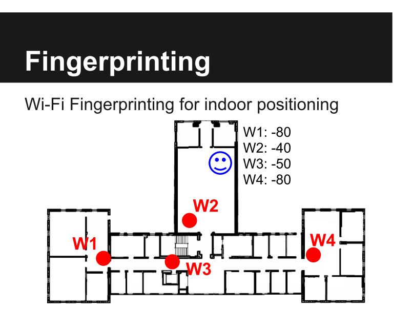
12 Fingerprinting 12
13 Fingerprinting Advantages Resistant to multipath and attenuation Disadvantages Requires data collection / site survey 13
 Location service providers such as Skyhook can take this info, look up the networks in a giant database, and perform trilateration for")
14 Crowd-Sourced WiFi Fingerprints WiFi fingerprinting can be done at large scale by recording which WiFi networks (SSID+MAC) are nearby (maybe +RSSI) Location service providers such as Skyhook can take this info, look up the networks in a giant database, and perform trilateration for you 14

15 Location from Sensors Many sensors on the phone can be helpful in determining location, especially due to mobility Dead reckoning Advantage: Needs no infrastructure Disadvantage: Error accumulates over time 15
16 Let's focus on GPS, arguably the most prominent location source for smartphones 16
17 GPS Global Position System was developed by the US DoD initially in the 1970s and completely operational in 1994 Similar to other systems deployed by Russia, EU, China, India, and others Satellites broadcast current time and location to allow any receiver on Earth to localize 17
18 Things using GPS GPS is used for: Automobile navigation (and autonomous driving) Mobile geo-location (for LBS, etc.) Livestock / wildlife tracking Aircraft and ship navigation and autopilot Power grid synchronization Financial transactions & trading Telecom system operations... 18
19 So, how does GPS actually work? 19
20 GPS Signals GPS satellites send several different signals On the L1 band ( MHz), coarse-acquisition (C/A) signal, encrypted precision (P(Y)) signal, L1 civilian (L1C) and military (M) codes On the L2 band ( MHz), P(Y) code, L2C and M Three other bands (L3, L4, L5) used for other purposes Nuclear detonation detection, atmospheric correction, civilian safety-of-life 20
 Dist d fr om (x,y 1 1 1,z ) @ t 1 1 m fro t d3 @ 3 ) st Di y,z 3, 3")
21 Multilateration GPS satellites serve as mobile reference points for Earth-based receivers All satellites have high-precision, tightly synchronized clocks and precisely known locations Each receiver hears a coordinate and timestamp from each transmitter, measures the distance based on the transmission time d 2 fro m (x 2,y 2,z ) Dist d fr om (x,y 1 1 1,z t 1 1 m fro t 3 ) st Di y,z 3, 3 (x 3 Dis t t 2 21
22 Measuring Distance Dist d1 from t1 How to measure distance from the satellite? Well, distance = speed of light * time, so just measure time... 22
23 Receiver Timing Dist d1 from t1 Satellites themselves use atomic clocks to maintain ground truth Receivers have to synchronize with the satellites Remember, 1ns time error 1ft distance error With clever processing, an extra satellite signal provides required synchronization 3 satellites for space, 4 for space+time 23

24 Errors Errors arise for many different reasons Scattering through Earth's atmosphere, reflection off buildings, time sync errors, etc. Much of this can be handled by incorporating proper models in the distance estimation process But, no longer just distance = rate * time Some receivers get diversity from using military & civilian signals 24
25 Military v. Civilian GPS Civilian GPS uses an unencrypted and unauthenticated signal for location and time synchronization Military GPS devices can be keyed to use an encrypted and authenticated signal for high assurance location and timing Military GPS requires key management, often in the form of manually entering long keys into handsets Use of the military signal can provide much higher accuracy, error correction, etc. 25

26 Military GPS Rumors Since manual key management is often an impediment to mission-critical activities, there have been reports that a large number of soldiers use GPS in civilian mode 26
27 Selective Availability When GPS was originally designed, it was intended to provide coarse-grained location for civilians and fine-grained location for military Does anyone remember when GPS accuracy was meters and that was good enough for most things? Selective Availability was eliminated around 2000 to provide higher accuracy for civilian applications Usually, we can get ~10 meter accuracy 27
28 Differential GPS For applications that require even better accuracy Differential GPS uses an additional signal sent from a ground station to compensate for errors in data sent by satellites E.g., DGPS stations can send difference between location claimed by satellite and its observed location Accuracy of ~10cm can be achieved using DGPS Appropriate for autonomous / swarm vehicle applications 28
29 What are the possible security issues with GPS? 29

 Jamming is")
30 Jamming GPS is based on wireless communication, so it's subject to interference GPS signals can be as quiet as -160dBm (10-19W) Jamming is pretty easy 30
31 Replay Attacks Replay of GPS transmissions would involve stale timestamps and location information The content of the message would be good But the time sync step would fail and most likely give unreasonable results Unless the timing is precisely controlled...more in a minute 31

32 GPS Spoofing Instead of replaying old GPS signals, fabricate new ones and pretend to be a satellite Spoofing leverages lack of authentication in civilian GPS signals Provides invalid information to the receiver to force it to compute an incorrect location Two types of spoofers have been demonstrated al n g i s g n i Spoof 32
33 Timed Replay as Spoofer Humphreys et al. built a spoofer (see [Humphreys et al., ION GNSS 2008]) It receives signals, analyzes them, and replays them after a precise delay The delay affects the distance measurement, thereby affecting the location result Precise control of delay allows gradual error accumulation or drifting, so detection is difficult 33
34 Many More Attacks GPS receivers are also vulnerable to a number of signal- and software-based attacks e.g., Middle-of-the-Earth attack See [Nighswander et al., CCS 2012] 34
35 How could you protect against these GPS attacks / threats... 35
36 without replacing or upgrading the satellite systems? 36
37 Deployment Constraints Because of the deployment cost, upgrading or replacing satellites is not really an option Maybe very slowly over time, but not any time soon So authentication is out GPS receivers have to respect what the GPS transmitters are sending even if they cannot authenticate them 37
38 Alternatives Several defense / mitigation strategies have been proposed by the GNSS community Modifying GPS receivers to use multiple antennas to verify angle of arrival consistency Augment receiver software to compare changes in location over time Incorporate sensor data (GPS says you're moving but gyro says you're not?) Incorporate other GNSS systems for diversity 38
39 What about Privacy? Location privacy is a huge problem We'll talk about it more a bit later in the semester 39
40 Oct 13 & 15: SoW Presentations Oct 20: NFC & Mobile Payment 40
Security of Global Navigation Satellite Systems (GNSS) GPS Fundamentals GPS Signal Spoofing Attack Spoofing Detection Techniques
 GPS Fundamentals GPS Signal Spoofing Attack Spoofing Detection Techniques") Security of Global Navigation Satellite Systems (GNSS) GPS Fundamentals GPS Signal Spoofing Attack Spoofing Detection Techniques Global Navigation Satellite Systems (GNSS) Umbrella term for navigation
Security of Global Navigation Satellite Systems (GNSS) GPS Fundamentals GPS Signal Spoofing Attack Spoofing Detection Techniques Global Navigation Satellite Systems (GNSS) Umbrella term for navigation
GLOBAL POSITIONING SYSTEMS
 GLOBAL POSITIONING SYSTEMS GPS & GIS Fall 2017 Global Positioning Systems GPS is a general term for the navigation system consisting of 24-32 satellites orbiting the Earth, broadcasting data that allows
Entity Tracking and Surveillance using the Modified Biometric System, GPS-3
 Advance in Electronic and Electric Engineering. ISSN 2231-1297, Volume 3, Number 9 (2013), pp. 1115-1120 Research India Publications http://www.ripublication.com/aeee.htm Entity Tracking and Surveillance
MOBILE COMPUTING 1/28/18. Location, Location, Location. Overview. CSE 40814/60814 Spring 2018
 MOBILE COMPUTING CSE 40814/60814 Spring 018 Location, Location, Location Location information adds context to activity: location of sensed events in the physical world location-aware services location
GPS: The Basics. Darrell R. Dean, Jr. Civil and Environmental Engineering West Virginia University. Expected Learning Outcomes for GPS
 GPS: The Basics Darrell R. Dean, Jr. Civil and Environmental Engineering West Virginia University Expected Learning Outcomes for GPS Explain the acronym GPS Name 3 important tdt dates in history of GPS
Time Firewall: Securing the GNSS receivers against Spoofing/Jamming. Shemi Prazot AccuBeat
 Time Firewall: Securing the GNSS receivers against Spoofing/Jamming Shemi Prazot AccuBeat 1 The need The GNSS systems are widely used for both navigation and timing in civilian infrastructures and military
GLOBAL POSITIONING SYSTEMS
 GLOBAL POSITIONING SYSTEMS Maps & Geospatial Concepts Fall 2015 Before GPS Historical look at navigation Giant concrete arrows that point your way across America What are these giant arrows? Some kind
Mobile Positioning in Wireless Mobile Networks
 Mobile Positioning in Wireless Mobile Networks Peter Brída Department of Telecommunications and Multimedia Faculty of Electrical Engineering University of Žilina SLOVAKIA Outline Why Mobile Positioning?
GPS/QZSS Signal Authentication Concept
 GPS/QZSS Signal Authentication Concept Dinesh Manandhar, Koichi Chino, Ryosuke Shibasaki The University of Tokyo Satoshi Kogure, Jiro Yamashita, Hiroaki Tateshita Japan Aerospace Exploration Agency (JAXA)
Channel Modeling ETIN10. Wireless Positioning
 Channel Modeling ETIN10 Lecture no: 10 Wireless Positioning Fredrik Tufvesson Department of Electrical and Information Technology 2014-03-03 Fredrik Tufvesson - ETIN10 1 Overview Motivation: why wireless
Public or Private (2)
") // Public or Private () CCST90 Mar, 0 Dr. Hayden Kwok-Hay So Department of Electrical and Electronic Engineering The Making of Google Street View Google Street View Systematically capture photos of the
// Public or Private () CCST90 Mar, 0 Dr. Hayden Kwok-Hay So Department of Electrical and Electronic Engineering The Making of Google Street View Google Street View Systematically capture photos of the
The GLOBAL POSITIONING SYSTEM James R. Clynch February 2006
 The GLOBAL POSITIONING SYSTEM James R. Clynch February 2006 I. Introduction What is GPS The Global Positioning System, or GPS, is a satellite based navigation system developed by the United States Defense
Prof. Maria Papadopouli
 Lecture on Positioning Prof. Maria Papadopouli University of Crete ICS-FORTH http://www.ics.forth.gr/mobile 1 Roadmap Location Sensing Overview Location sensing techniques Location sensing properties Survey
IoT. Indoor Positioning with BLE Beacons. Author: Uday Agarwal
 IoT Indoor Positioning with BLE Beacons Author: Uday Agarwal Contents Introduction 1 Bluetooth Low Energy and RSSI 2 Factors Affecting RSSI 3 Distance Calculation 4 Approach to Indoor Positioning 5 Zone
GPS Global Positioning System
 GPS Global Positioning System 10.04.2012 1 Agenda What is GPS? Basic consept History GPS receivers How they work Comunication Message format Satellite frequencies Sources of GPS signal errors 10.04.2012
Agenda Motivation Systems and Sensors Algorithms Implementation Conclusion & Outlook
 Overview of Current Indoor Navigation Techniques and Implementation Studies FIG ww 2011 - Marrakech and Christian Lukianto HafenCity University Hamburg 21 May 2011 1 Agenda Motivation Systems and Sensors
IOT GEOLOCATION NEW TECHNICAL AND ECONOMICAL OPPORTUNITIES
 IOT GEOLOCATION NEW TECHNICAL AND ECONOMICAL OPPORTUNITIES Florian LECLERE f.leclere@kerlink.fr EOT Conference Herning 2017 November 1st, 2017 AGENDA 1 NEW IOT PLATFORM LoRa LPWAN Platform Geolocation
A Review of Vulnerabilities of ADS-B
 A Review of Vulnerabilities of ADS-B S. Sudha Rani 1, R. Hemalatha 2 Post Graduate Student, Dept. of ECE, Osmania University, 1 Asst. Professor, Dept. of ECE, Osmania University 2 Email: ssrani.me.ou@gmail.com
IoT Wi-Fi- based Indoor Positioning System Using Smartphones
 IoT Wi-Fi- based Indoor Positioning System Using Smartphones Author: Suyash Gupta Abstract The demand for Indoor Location Based Services (LBS) is increasing over the past years as smartphone market expands.
Jamming and Spoofing of GNSS Signals An Underestimated Risk?!
 Jamming and Spoofing of GNSS Signals An Underestimated Risk?! Alexander Rügamer Dirk Kowalewski Fraunhofer IIS NavXperience GmbH Fraunhofer IIS 1 Source: http://securityaffairs.co/wordpress/wpcontent/uploads/2012/02/spoofing.jpg
DEFINING THE FUTURE OF SATELLITE SURVEYING WITH TRIMBLE R-TRACK TECHNOLOGY
 DEFINING THE FUTURE OF SATELLITE SURVEYING WITH TRIMBLE R-TRACK TECHNOLOGY EDMOND NORSE, GNSS PORTFOLIO MANAGER, TRIMBLE SURVEY DIVISION WESTMINSTER, CO USA ABSTRACT In September 2003 Trimble introduced
S a t e l l i t e T i m e a n d L o c a t i o n. N o v e m b e r John Fischer VP Advanced R&D
 STL - S a t e l l i t e T i m e a n d L o c a t i o n N o v e m b e r 2 0 1 7 John Fischer VP Advanced R&D jfischer@orolia.com 11/28/201 1 7 WHY AUGMENT GNSS? Recent UK Study Economic Input to UK of a
The Global Positioning System
 The Global Positioning System 5-1 US GPS Facts of Note DoD navigation system First launch on 22 Feb 1978, fully operational in 1994 ~$15 billion (?) invested to date 24 (+/-) Earth-orbiting satellites
GPS and Recent Alternatives for Localisation. Dr. Thierry Peynot Australian Centre for Field Robotics The University of Sydney
 GPS and Recent Alternatives for Localisation Dr. Thierry Peynot Australian Centre for Field Robotics The University of Sydney Global Positioning System (GPS) All-weather and continuous signal system designed
GBAS FOR ATCO. June 2017
 GBAS FOR ATCO June 2017 Disclaimer This presentation is for information purposes only. It should not be relied on as the sole source of information, and should always be used in the context of other authoritative
Ensuring Robust Precision Time: Hardened GNSS, Multiband, and Atomic Clocks. Lee Cosart WSTS 2018
 Power Matters. Ensuring Robust Precision Time: Hardened GNSS, Multiband, and Atomic Clocks Lee Cosart lee.cosart@microsemi.com WSTS 2018 Outline Introduction The Challenge Time requirements increasingly
GPS Milestones, cont. GPS Milestones. The Global Positioning Sytem, Part 1 10/10/2017. M. Helper, GEO 327G/386G, UT Austin 1. US GPS Facts of Note
 The Global Positioning System US GPS Facts of Note DoD navigation system First launch on 22 Feb 1978, fully operational in 1994 ~$15 billion (?) invested to date 24 (+/-) Earth-orbiting satellites (SVs)
MOBILE COMPUTING 1/29/18. Cellular Positioning: Cell ID. Cellular Positioning - Cell ID with TA. CSE 40814/60814 Spring 2018
 MOBILE COMPUTING CSE 40814/60814 Spring 2018 Cellular Positioning: Cell ID Open-source database of cell IDs: opencellid.org Cellular Positioning - Cell ID with TA TA: Timing Advance (time a signal takes
Digital Surveillance Devices?
 Technology Framework Tracking Technologies Don Mason Associate Director Digital Surveillance Devices? Digital Surveillance Devices? Secure Continuous Remote Alcohol Monitor SCRAM Page 1 Location Tracking
Digital surveillance devices?
 Technology Framework Tracking Technologies Don Mason Associate Director Copyright 2011 National Center for Justice and the Rule of Law All Rights Reserved Digital surveillance devices? Digital surveillance
Surviving and Operating Through GPS Denial and Deception Attack. Nathan Shults Kiewit Engineering Group Aaron Fansler AMPEX Intelligent Systems
 Surviving and Operating Through GPS Denial and Deception Attack Nathan Shults Kiewit Engineering Group Aaron Fansler AMPEX Intelligent Systems How GPS Works GPS Satellite sends exact time (~3 nanoseconds)
Introduction to the Global Positioning System
 GPS for Fire Management - 2004 Introduction to the Global Positioning System Pre-Work Pre-Work Objectives Describe at least three sources of GPS signal error, and identify ways to mitigate or reduce those
Localization: Algorithms and System
 Localization: Algorithms and System Applications of Location Information Location aware information services e.g., E911, location-based search, target advertisement, tour guide, inventory management, traffic
GNSS Technologies. GNSS integration with other positioning methods
 GNSS Technologies GNSS integration with other positioning methods 1 29.3.2017 Content Location system alternatives RF types and classifications Locationing using RF signals Cellular positioning DTV-signal
Wireless Network Security Spring 2016
 Wireless Network Security Spring 2016 Patrick Tague Class #5 Jamming (cont'd); Physical Layer Security 2016 Patrick Tague 1 Class #5 Anti-jamming Physical layer security Secrecy using physical layer properties
Tracking New Signals from Space GPS Modernization and Trimble R-Track Technology
 Tracking New Signals from Space GPS Modernization and Trimble R-Track Technology Edmond T. Norse Trimble Integrated Surveying Group, Westminster, Colorado U.S. TRIMBLE 2 Tracking New Signals from Space
Protection Augmentation Toughness and Alternatives of GNSS. Melaha 2016 Concord Al-Salam Hotel Cairo, April 25,2016 Refaat Rashad
 Protection Augmentation Toughness and Alternatives of GNSS Melaha 2016 Concord Al-Salam Hotel Cairo, April 25,2016 Refaat Rashad Road Map of the Presentation 1- How Good are GNSS 2- How Vulnerable are
The Next Generation of Secure Position, Navigation and Timing Technology
 Navigation and Timing Technology November 2017 Contents Executive Summary 2 GPS on the Battlefield 2 Vulnerabilities of GPS 2 Staying Ahead of the Threat 3 Innovating For More Resilient PNT 3 Innovative,
Global Navigation Satellite Systems (GNSS)Part I EE 570: Location and Navigation
Part I EE 570: Location and Navigation") Lecture Global Navigation Satellite Systems (GNSS)Part I EE 570: Location and Navigation Lecture Notes Update on April 25, 2016 Aly El-Osery and Kevin Wedeward, Electrical Engineering Dept., New Mexico
Lecture Global Navigation Satellite Systems (GNSS)Part I EE 570: Location and Navigation Lecture Notes Update on April 25, 2016 Aly El-Osery and Kevin Wedeward, Electrical Engineering Dept., New Mexico
Jager UAVs to Locate GPS Interference
 JIFX 16-1 2-6 November 2015 Camp Roberts, CA Jager UAVs to Locate GPS Interference Stanford GPS Research Laboratory and the Stanford Intelligent Systems Lab Principal Investigator: Sherman Lo, PhD Area
SMART RFID FOR LOCATION TRACKING
 SMART RFID FOR LOCATION TRACKING By: Rashid Rashidzadeh Electrical and Computer Engineering University of Windsor 1 Radio Frequency Identification (RFID) RFID is evolving as a major technology enabler
HOW TO RECEIVE UTC AND HOW TO PROVE ACCURACY
 HOW TO RECEIVE UTC AND HOW TO PROVE ACCURACY Marc Weiss, Ph.D. Independent Consultant to Booz Allen Hamilton Weiss_Marc@ne.bah.com Innovation center, Washington, D.C. JANUARY 23, 2018 HOW DO YOU GET UTC
36. Global Positioning System
 36. Introduction to the Global Positioning System (GPS) Why do we need GPS? Position: a basic need safe sea travel, crowed skies, resource management, legal questions Positioning: a challenging job local
What is a GPS How does GPS work? GPS Segments GPS P osition Position Position Accuracy Accuracy Accuracy GPS A pplications Applications Applications
 What is GPS? What is a GPS How does GPS work? GPS Segments GPS Position Accuracy GPS Applications What is GPS? The Global Positioning System (GPS) is a precise worldwide radio-navigation system, and consists
Proceedings of Al-Azhar Engineering 7 th International Conference Cairo, April 7-10, 2003.
 Proceedings of Al-Azhar Engineering 7 th International Conference Cairo, April 7-10, 2003. MODERNIZATION PLAN OF GPS IN 21 st CENTURY AND ITS IMPACTS ON SURVEYING APPLICATIONS G. M. Dawod Survey Research
Power Utilities Mitigating GPS Vulnerabilities and Protecting Power Utility Network Timing
 Mitigating GPS Vulnerabilities and Protecting Power Utility Network Timing Introduction The Global Positioning System (GPS) is ubiquitous as a source of precise timing for utility data networks and power
Future Dual Systems for Landing. The DGNSS PALS opportunity Marco Donfrancesco Intelligence & Cyber EW Sales & Mktg
 Future Dual Systems for Landing. The DGNSS PALS opportunity Marco Donfrancesco Intelligence & Cyber EW Sales & Mktg SG-175 DGNSS PALS study The study shall provide technical advice on the data link capabilities
CARRIER PHASE VS. CODE PHASE
 DIFFERENTIAL CORRECTION Code phase processing- GPS measurements based on the pseudo random code (C/A or P) as opposed to the carrier of that code. (1-5 meter accuracy) Carrier phase processing- GPS measurements
Wireless Network Security Spring 2015
 Wireless Network Security Spring 2015 Patrick Tague Class #5 Jamming, Physical Layer Security 2015 Patrick Tague 1 Class #5 Jamming attacks and defenses Secrecy using physical layer properties Authentication
Introduction. Global Positioning System. GPS - Intro. Space Segment. GPS - Intro. Space Segment - Contd..
 Introduction Global Positioning System Prof. D. Nagesh Kumar Dept. of Civil Engg., IISc, Bangalore 560 012, India URL: http://www.civil.iisc.ernet.in/~nagesh GPS is funded and controlled by U. S. Department
NR402 GIS Applications in Natural Resources
 NR402 GIS Applications in Natural Resources Lesson 5 GPS/GIS integration Global Positioning System (GPS)..a global navigation system that everyone can use What is GPS? How does it work? How accurate is
V2X-Locate Positioning System Whitepaper
 V2X-Locate Positioning System Whitepaper November 8, 2017 www.cohdawireless.com 1 Introduction The most important piece of information any autonomous system must know is its position in the world. This
Location Tracking. Current Technologies 1/19/2011. Not one, single technology Convergence of several technologies. Systems for
 Don Mason Associate Director Copyright 2011 National Center for Justice and the Rule of Law All Rights Reserved Location Tracking Not one, single technology Convergence of several technologies Systems
Cooperative navigation: outline
 Positioning and Navigation in GPS-challenged Environments: Cooperative Navigation Concept Dorota A Grejner-Brzezinska, Charles K Toth, Jong-Ki Lee and Xiankun Wang Satellite Positioning and Inertial Navigation
LOCALIZATION WITH GPS UNAVAILABLE
 LOCALIZATION WITH GPS UNAVAILABLE ARES SWIEE MEETING - ROME, SEPT. 26 2014 TOR VERGATA UNIVERSITY Summary Introduction Technology State of art Application Scenarios vs. Technology Advanced Research in
GNSS RFI/Spoofing: Detection, Localization, & Mitigation
 GNSS RFI/Spoofing: Detection, Localization, & Mitigation Stanford's 2012 PNT Challenges and Opportunities Symposium 14 - November - 2012 Dennis M. Akos University of Colorado/Stanford University with contributions
Lecture-1 CHAPTER 2 INTRODUCTION TO GPS
 Lecture-1 CHAPTER 2 INTRODUCTION TO GPS 2.1 History of GPS GPS is a global navigation satellite system (GNSS). It is the commonly used acronym of NAVSTAR (NAVigation System with Time And Ranging) GPS (Global
King AbdulAziz University. Faculty of Environmental Design. Geomatics Department. Mobile GIS GEOM 427. Lecture 3
 King AbdulAziz University Faculty of Environmental Design Geomatics Department Mobile GIS GEOM 427 Lecture 3 Ahmed Baik, Ph.D. Email: abaik@kau.edu.sa Eng. Fisal Basheeh Email: fbasaheeh@kau.edu.sa GNSS
Next Generation Positioning Infrastructure
 Next Generation Positioning Infrastructure The GNSS Network in the 21 st Century Joel VAN CRANENBROECK & Partners Beyond East & West GeoSensing Community 1 INFRASTRUCTURE "The installations that form the
GNSS Threats at Airports and detecting them
 GNSS Threats at Airports and detecting them Guy Buesnel, Romain Zimmermann, October 2017 Overview of Spirent Positioning and Timing Mobile Devices Military Applications Commercial Air Travel Automotive
Location, Location, Location
 Location, Location, Location Larry Rudolph 1 Outline Administrative remarks and requests Positioning Technology GPS and others Location Specifiers Privacy Issues Asking for help For 3rd edition phones,
Global Positioning Systems (GPS) Trails: the achilles heel of mapping from the air / satellites
 Trails: the achilles heel of mapping from the air / satellites") Global Positioning Systems (GPS) Trails: the achilles heel of mapping from the air / satellites Google maps updated regularly by local users using GPS Also: http://openstreetmaps.org GPS applications
Global Positioning Systems (GPS) Trails: the achilles heel of mapping from the air / satellites Google maps updated regularly by local users using GPS Also: http://openstreetmaps.org GPS applications
An Introduction to Airline Communication Types
 AN INTEL COMPANY An Introduction to Airline Communication Types By Chip Downing, Senior Director, Aerospace & Defense WHEN IT MATTERS, IT RUNS ON WIND RIVER EXECUTIVE SUMMARY Today s global airliners use
Understanding GPS: Principles and Applications Second Edition
 Understanding GPS: Principles and Applications Second Edition Elliott Kaplan and Christopher Hegarty ISBN 1-58053-894-0 Approx. 680 pages Navtech Part #1024 This thoroughly updated second edition of an
Future GNSS: Improved Signals and Constellations
 Future GNSS: Improved Signals and Constellations Guillermo Martínez Morán 1 1 Airbus Defense & Space. Paseo John Lennon s/n 28096 Getafe (Madrid Spain) Guillermo.M.Martinez@military.airbus.com Abstract:
The Case for Recording IF Data for GNSS Signal Forensic Analysis Using a SDR
 The Case for Recording IF Data for GNSS Signal Forensic Analysis Using a SDR Professor Gérard Lachapelle & Dr. Ali Broumandan PLAN Group, University of Calgary PLAN.geomatics.ucalgary.ca IGAW 2016-GNSS
Localization in WSN. Marco Avvenuti. University of Pisa. Pervasive Computing & Networking Lab. (PerLab) Dept. of Information Engineering
 Dept. of Information Engineering") Localization in WSN Marco Avvenuti Pervasive Computing & Networking Lab. () Dept. of Information Engineering University of Pisa m.avvenuti@iet.unipi.it Introduction Location systems provide a new layer
Localization in WSN Marco Avvenuti Pervasive Computing & Networking Lab. () Dept. of Information Engineering University of Pisa m.avvenuti@iet.unipi.it Introduction Location systems provide a new layer
UNIT 1 - introduction to GPS
 UNIT 1 - introduction to GPS 1. GPS SIGNAL Each GPS satellite transmit two signal for positioning purposes: L1 signal (carrier frequency of 1,575.42 MHz). Modulated onto the L1 carrier are two pseudorandom
EE 570: Location and Navigation
 EE 570: Location and Navigation Global Navigation Satellite Systems (GNSS) Part I Aly El-Osery Kevin Wedeward Electrical Engineering Department, New Mexico Tech Socorro, New Mexico, USA In Collaboration
Primer on GPS Operations
 MP Rugged Wireless Modem Primer on GPS Operations 2130313 Rev 1.0 Cover illustration by Emma Jantz-Lee (age 11). An Introduction to GPS This primer is intended to provide the foundation for understanding
RESPONSE TO THE HOUSE OF COMMONS TRANSPORT SELECT COMMITTEE INQUIRY INTO GALILEO. Memorandum submitted by The Royal Academy of Engineering
 RESPONSE TO THE HOUSE OF COMMONS TRANSPORT SELECT COMMITTEE INQUIRY INTO GALILEO Memorandum submitted by The Royal Academy of Engineering September 2004 Executive Summary The Royal Academy of Engineering
Applying Defence-in-depth to counter RF interferences over GNSS
 Applying Defence-in-depth to counter RF interferences over GNSS IET 5th Oct. 2011 Xavier Bertinchamps - GSA Objective of this presentation Understand Jamming threat on GNSS Propose a comprehensive strategy
Technology Talk Bulletin
 Technology Talk Bulletin This Technology Talk Bulletin compares John Deere dealer s current Real Time Kinematic (RTK) base station approach to the different RTK technologies available. What is RTK? RTK
The Effect of Radio Frequency Interference on GNSS Signals and Mitigation Techniques Presented by Dr. Tarek Attia
 International Conference and Exhibition Melaha2016 GNSS WAY Ahead 25-27 April2016, Cairo, Egypt The Effect of Radio Frequency Interference on GNSS Signals and Mitigation Techniques Presented by Dr. Tarek
Smartphone Positioning and 3D Mapping Indoors
 Smartphone Positioning and 3D Mapping Indoors Ruizhi Chen Wuhan University Oct. 4, 2018, Delft Adding a Smart LIFE to 3D People spend 80% of their time indoors When People Communicates to a Robot, We Need
GNSS Training for ITS Developers. Characterisation of EGNSS performances in relationship with the application requirements
 GNSS Training for ITS Developers Characterisation of EGNSS performances in relationship with the application requirements Table of Content egnss for Application: Main Challenges EGNOS and GALILEO Performances
Evaluating OTDOA Technology for VoLTE E911 Indoors
 Evaluating OTDOA Technology for VoLTE E911 Indoors Introduction As mobile device usage becomes more and more ubiquitous, there is an increasing need for location accuracy, especially in the event of an
High Precision GNSS in Automotive
 High Precision GNSS in Automotive Jonathan Auld, VP Engineering and Safety 6, March, 2018 2 Global OEM Positioning Solutions and Services for Land, Sea, and Air. GNSS in Automotive Today Today the primary
High Precision Urban and Indoor Positioning for Public Safety
 High Precision Urban and Indoor Positioning for Public Safety NextNav LLC September 6, 2012 2012 NextNav LLC Mobile Wireless Location: A Brief Background Mass-market wireless geolocation for wireless devices
Indoor Positioning by the Fusion of Wireless Metrics and Sensors
 Indoor Positioning by the Fusion of Wireless Metrics and Sensors Asst. Prof. Dr. Özgür TAMER Dokuz Eylül University Electrical and Electronics Eng. Dept Indoor Positioning Indoor positioning systems (IPS)
ECS455: Chapter 4 Multiple Access
 ECS455: Chapter 4 Multiple Access 4.9 Async. CDMA: Gold codes and GPS 1 Dr.Prapun Suksompong prapun.com/ecs455 Office Hours: BKD 3601-7 Tuesday 9:30-10:30 Tuesday 13:30-14:30 Thursday 13:30-14:30 Asynchronous
Case sharing of the use of RF Localization Techniques. Dr. Frank Tong LSCM R&D Centre LSCM Summit 2015
 Case sharing of the use of RF Localization Techniques Dr. Frank Tong LSCM R&D Centre LSCM Summit 2015 Outline A. LBS tracking and monitoring 1) Case of anti-wandering-off tracking vest system in elderly
Enhancing Bluetooth Location Services with Direction Finding
 Enhancing Bluetooth Location Services with Direction Finding table of contents 1.0 Executive Summary...3 2.0 Introduction...4 3.0 Bluetooth Location Services...5 3.1 Bluetooth Proximity Solutions 5 a.
Introduction to the Global Positioning System
 GPS for ICS - 2003 Introduction to the Global Positioning System Pre-Work Pre-Work Objectives Describe at least three sources of GPS signal error, and ways to mitigate or reduce those errors. Identify
Alternative Positioning, Navigation and Timing (APNT) for Performance Based Navigation (PBN)
 for Performance Based Navigation (PBN)") DLR.de Chart 1 Alternative Positioning, Navigation and Timing (APNT) for Performance Based Navigation (PBN) Presented by Boubeker Belabbas Prepared by : Nicolas Schneckenburger, Elisabeth Nossek, Dmitriy
DLR.de Chart 1 Alternative Positioning, Navigation and Timing (APNT) for Performance Based Navigation (PBN) Presented by Boubeker Belabbas Prepared by : Nicolas Schneckenburger, Elisabeth Nossek, Dmitriy
DYNAMICALLY RECONFIGURABLE SOFTWARE DEFINED RADIO FOR GNSS APPLICATIONS
 DYNAMICALLY RECONFIGURABLE SOFTWARE DEFINED RADIO FOR GNSS APPLICATIONS Alison K. Brown (NAVSYS Corporation, Colorado Springs, Colorado, USA, abrown@navsys.com); Nigel Thompson (NAVSYS Corporation, Colorado
matthew ahrens* December, 12th, 2014
 G P S A N D W I R E L E S S S I G N A L J A M M I N G : AT TA C K S A N D D E F E N S E S matthew ahrens* December, 12th, 2014 contents 1 Introduction 2 1.1 History of GPS........................... 2
Canadian Coast Guard Review to Implement a Resilient Position, Navigation and Timing Solution for Canada. Mariners Workshop January 31 st, 2018
 Canadian Coast Guard Review to Implement a Resilient Position, Navigation and Timing Solution for Canada Mariners Workshop January 31 st, 2018 Outline Overview of GNSS use in the marine sector CCG Activities
Assessing the likelihood of GNSS spoofing attacks on RPAS
 Assessing the likelihood of GNSS spoofing attacks on RPAS Mike Maarse UvA/NLR 30-06-2016 Mike Maarse (UvA/NLR) RP2 Presentation 30-06-2016 1 / 25 Introduction Motivation/relevance Growing number of RPAS
Pixie Location of Things Platform Introduction
 Pixie Location of Things Platform Introduction Location of Things LoT Location of Things (LoT) is an Internet of Things (IoT) platform that differentiates itself on the inclusion of accurate location awareness,
THE IMPLEMENTATION OF INDOOR CHILD MONITORING SYSTEM USING TRILATERATION APPROACH
 THE IMPLEMENTATION OF INDOOR CHILD MONITORING SYSTEM USING TRILATERATION APPROACH Normazatul Shakira Darmawati and Nurul Hazlina Noordin Faculty of Electrical & Electronics Engineering, Universiti Malaysia
Benefits and Limitations of New GNSS Signal Designs. Dr. A. J. Van Dierendonck AJ Systems, USA November 18, 2014
 Benefits and Limitations of New GNSS Signal Designs Dr. A. J. Van Dierendonck AJ Systems, USA November 18, 2014 My Opinions on New GNSS Signal Designs This briefing is loosely based upon Leadership Series
GLOBAL POSITIONING SYSTEMS. Knowing where and when
 GLOBAL POSITIONING SYSTEMS Knowing where and when Overview Continuous position fixes Worldwide coverage Latitude/Longitude/Height Centimeter accuracy Accurate time Feasibility studies begun in 1960 s.
Location Based Technologies
 Location Based Technologies I have often wondered whether people really understand Location Based Services (LBS) technology and whether they would like a bit more insight into how exactly location based
GNSS MONITORING NETWORKS
 SPACE GNSS MONITORING NETWORKS Satellite communications, earth observation, navigation and positioning and control stations indracompany.com GNSS MONITORING NETWORKS GNSS MONITORING NETWORKS Indra s solutions
Module Introduction. Purpose The intent of this module is to provide you with an overview of the Global Positioning System.
 Purpose The intent of this module is to provide you with an overview of the Global Positioning System. Objectives Explain the basic concept of GPS. Identify various applications of GPS. Describe how GPS
The topic we are going to see in this unit, the global positioning system, is not directly related with the computer networks we use everyday, but it
 The topic we are going to see in this unit, the global positioning system, is not directly related with the computer networks we use everyday, but it is indeed a kind of computer network, as the specialised
Boeing Timing & Location
 Boeing Defense, Space & Security PhantomWorks Boeing Timing & Location An Indoor Capable Time Transfer and Geolocation System Presentation Stanford PNT Symposium David Whelan Gregory Gutt Per Enge November
GPS Modernization and Program Update
 GPS Modernization and Program Update GPS Update to ION Southern California Chapter 22 Feb 2011 Colonel Bernie Gruber Director Global Positioning Systems Directorate Contents Current Constellation Modernization
Integrated GPS/TOA Navigation using a Positioning and Communication Software Defined Radio
 Integrated GPS/TOA Navigation using a Positioning and Communication Software Defined Radio Alison Brown and Janet Nordlie NAVSYS Corporation 96 Woodcarver Road Colorado Springs, CO 89 Abstract-While GPS