The World s First Triple Nested HF Radar Test Bed for Current Mapping and Ship Detection
|
|
|
- Brent Sanders
- 5 years ago
- Views:
Transcription


1 The World s First Triple Nested HF Radar Test Bed for Current Mapping and Ship Detection Hugh Roarty Scott Glenn Josh Kohut Rutgers University Don Barrick Pam Kung CODAR Ocean Sensors
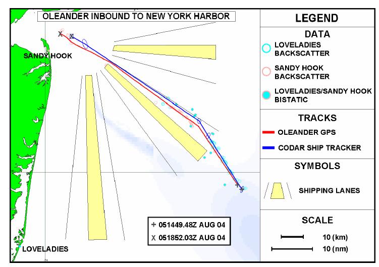
2 FUTURE WORK (ROW4) System Performance in Varied Environments Based upon the shown work, optimal settings have been set at all long-range sites for multi-static dual use operations Now focusing on a long term data set, M/V Oleander sails New York to Bermuda on a weekly basis providing ship tracking opportunities while the network continues to provide surface current maps to the Coast Guard for Search & Rescue Demonstrations. Multiple Frequencies Sandy Hook: 5, 13 and 25 MHz Multiple Sites Sandy Hook Loveladies Tuckerton & Wildwood

3 Ship Tracking Throughout Rutgers HF Radar Network
4 60 Transits of Oleander in 2005


5 New Jersey Installations 5 MHz Loveladies, NJ Used for Oleander Tests 5 MHz Sandy Hook,NJ
6 Detection Algorithm Simultaneous multiple sliding window FFTs in Doppler processing Two types of background calculation --- median and IIR 3D background (Time, Range and Doppler) varying with sea echoes Thresholding of peaks --- local SNR of monopole or at least one of the two dipole antennas have to be above the threshold MUSIC algorithm used to determine bearing Bearing precision determined by SNR (~1/sqrt(SNR))


7 Oleander Detections 128 point FFT 6 db Threshold 256 point FFT 7 db Threshold 512 point FFT 8 db Threshold

8 Ship Tracking Algorithm A Kalman Filter provides a recursive solution to the least squares problem. Assumptions include linear target motion and normally distributed measurement errors. Tracker inputs are time; radar transmitter and receiver positions; range, bearing, and range rate; and range, bearing, and range rate uncertainties. Tracker outputs are target position; velocity; and estimates of position and velocity uncertainties (covariance matrix). Oleander Constant Course and Speed Tracker Solution Using CODAR Detections from 23 November 2002 Target Maneuver Test: a statistical test is used to estimate whether a combination of two straight tracks fit the data better than a single straight track.
9 Pepper Plots All targets detected 9 db above background
10
11 Present Focus Hardware Improvements 13 MHz Codar SeaSonde, December MHz Codar Superdirective System, July 2005 Software Improvements SIFTER Algorithm
12 Sandy Hook Facility March MHz Rx 5 MHz Tx Continuous Operation Since July 2001
13 Sandy Hook Test Bed Present Day 25 MHz system installed March MHz Rx 5 MHz Tx 5 MHz Tx 13 MHz Rx 25 MHz Tx/Rx 13 MHz Tx 5 MHz Transmit Antenna moved 1 wavelength back from shoreline 13 MHz System Installed December 2004

14 25 MHz 5 MHz Rx Tx/Rx 13 MHz Tx 13 MHz Rx 5 MHz Tx

15 Three Frequency Coverage 5 MHz 13 MHz 25 MHz
16 How did the move of the Transmit Antenna Affect Radial 5 MHz Rx Coverage? 5 MHz Tx 5 MHz Tx

17 5 MHz Transmit Antenna Move BEFORE AFTER Radial Distribution November 2004 Radial Distribution April 2005

18 5 & 13 MHz Receive Antennas in Cluttered Environment
19 5 MHz HOOK Pattern Measurement
20 Simulated Bearing Error with Added Bias from Improper Antenna Pattern Compared with Real Ship Bearing Data For Simulation: Measured distorted pattern inputted Ideal pattern used to recover echo Expected power-law fit is offset by 16 Ship is also offset when inappropriate ideal pattern is used
21 Simulated Bearing Error with Distorted, Measured Antenna Patterns Compared with Real Ship Bearing Data Simulated points follow power law: σ B = 36.4 SN R 0.67 Compared to: σ B = 40 SN R 0.5 Ship detections at lower SNRs may differ because: Noise peaks are mis-identified as ships "Noise" near peak contains ship signal, i.e., it is too high

22 13 MHz HOMR Pattern Measurement Radial Distribution
23 25 MHz System in Clear Environment


24 25 MHz HOSR Pattern Measurement Radial Distribution
25

26 Sandy Hook Test Bed 13 MHz SuperDirective 5 MHz Rx Future 13 MHz SuperDirective System Installation July MHz Tx 13 MHz Rx 25 MHz Tx/Rx 13 MHz Tx
")
 dipoles 2 masts ~21 db directivity over")
27 SuperDirective System 13-MHz Heptagonal Array Being Built and Tested at CODAR 23-foot (7-m) high mast 9-foot (3-m) arms 8-foot (2.7-m) dipoles 2 masts ~21 db directivity over ground -32 db efficiency
28 SuperDirective Beam Patterns 360 degree coverage Blue curve is theoretical pattern for 7-element array Red results from use of measured transponder pattern
29 IGNAL NVERSION OR ARGET XTRACTION & EGISTRATION Developed by Mission Research Corporation (MRC) Originally developed for ROTHR (Relocatable Over The Horizon Radar) SIFTER rejects peaks that do not move in a consistent way SIFTER finds smoothest distribution of scatterers that reproduces HFSWR or ROTHR measurements Targets appear as localized peaks

30 SIFTER Results
31
32 Future Work Utilize AIS signal to ground truth multiple ship tracks New and Different Targets


33 Automatic Identification System (AIS) Required on vessels of: 300 gross tonnage or greater, Length Over All (LOA) over 20 meters, or carries more than 50 passengers for hire


34 135 R/V Cape Hatteras 47 Motor Lifeboat 177 R/V Oceanus 87 Coastal Patrol Boat 32 Go-Fast Boat
35 GPS Track of RV Cape Hatteras during LATTE 2005
A Bistatic HF Radar for Current Mapping and Robust Ship Tracking
 A Bistatic HF Radar for Current Mapping and Robust Ship Tracking Dennis Trizna Imaging Science Research, Inc. V. 703-801-1417 dennis @ isr-sensing.com www.isr-sensing.com Objective: Develop methods for
CODAR. Ben Kravitz September 29, 2009
 CODAR Ben Kravitz September 29, 2009 Outline What is CODAR? Doppler shift Bragg scatter How CODAR works What CODAR can tell us What is CODAR? Coastal Ocean Dynamics Application Radar Land-based HF radar
HF-Radar Network Near-Real Time Ocean Surface Current Mapping
 HF-Radar Network Near-Real Time Ocean Surface Current Mapping The HF-Radar Network (HFRNet) acquires surface ocean radial velocities measured by HF-Radar through a distributed network and processes the
Geometric Dilution of Precision of HF Radar Data in 2+ Station Networks. Heather Rae Riddles May 2, 2003
 Geometric Dilution of Precision of HF Radar Data in + Station Networks Heather Rae Riddles May, 003 Introduction The goal of this Directed Independent Study (DIS) is to provide a basic understanding of
Dual Use Multi-Frequency Radar For Current Shear Mapping and Ship Target Classification
 Dual Use Multi-Frequency Radar For Current Shear Mapping and Ship Target Classification Dennis B. Trizna, Ph. D. Imaging Science Research, Inc. 9310A Old Keene Mill Road Burke, VA 22015 V 703 801-1417,
Assessment of HF Radar for Significant Wave Height Determination. Desmond Power VP, Remote Sensing, C-CORE
 Assessment of HF Radar for Significant Wave Height Determination Desmond Power VP, Remote Sensing, C-CORE Study Rationale Agenda Technology Overview Technology Assessment for CNLOPB Proposed Go Forward
An Introduction to High Frequency Surface Wave Radar
 An Introduction to High Frequency Surface Wave Radar Dr. Hugh Roarty Dr. Scott Glenn Presented by: Trevor Bartleet (Peralex Electronics) The Radar Masters Course at UCT http://radarmasters.co.za/ Set up
Profiling River Surface Velocities and Volume Flow Estmation with Bistatic UHF RiverSonde Radar
 Profiling River Surface Velocities and Volume Flow Estmation with Bistatic UHF RiverSonde Radar Don Barrick Ralph Cheng Cal Teague Jeff Gartner Pete Lilleboe U.S. Geological Survey CODAR Ocean Sensors,
A Bistatic HF Radar for Current Mapping and Robust Ship Tracking
 A Bistatic HF Radar for Current Mapping and Robust Ship Tracking D. B. Trizna Imaging Science Research, Inc. 6103B Virgo Court Burke, VA, 22015 USA Abstract- A bistatic HF radar has been developed for
Drift Ice Detection by HF radar off Mombetsu
 Drift Ice Detection by HF radar off Mombetsu 凘 氷解而流也 Wei Zhang 1, Naoto Ebuchi 1, Brian Emery 2 and Hiroto Abe 1 1 Institute of Low Temperature Science, Hokkaido University 1 2 Marine Science Institute,
Estimation and Assessment of Errors Related to Antenna Pattern Distortion in CODAR SeaSonde High-Frequency Radar Ocean Current Measurements
 JUNE 2010 L A W S E T A L. 1029 Estimation and Assessment of Errors Related to Antenna Pattern Distortion in CODAR SeaSonde High-Frequency Radar Ocean Current Measurements KENNETH LAWS University of California,
OC3570 PROJECT REPORT: A COMPARISON OF COASTAL CURRENTS USING LAND BASED HF RADAR AND SHIP BOARD ADCP OBSERVATIONS. LCDR Steve Wall, RAN Winter 2007
 OC3570 PROJECT REPORT: A COMPARISON OF COASTAL CURRENTS USING LAND BASED HF RADAR AND SHIP BOARD ADCP OBSERVATIONS LCDR Steve Wall, RAN Winter 2007 Background High Frequency (HF) radar between 3 and 30MHz
APPLICATION OF OCEAN RADAR ON THE BALTIC, FEATURES AND LIMITATIONS
 APPLICATION OF OCEAN RADAR ON THE BALTIC, FEATURES AND LIMITATIONS Thomas Helzel, Matthias Kniephoff, Leif Petersen, Markus Valentin Helzel Messtechnik GmbH e-mail: helzel@helzel.com Presentation at Hydro
Copyright 2016 Raytheon Company. All rights reserved. Customer Success Is Our Mission is a registered trademark of Raytheon Company.
 Make in India Paradigm : Roadmap for a Future Ready Naval Force Session 9: Coastal Surveillance, Response Systems and Platforms Nik Khanna, President, India April 19, 2016 "RAYTHEON PROPRIETARY DATA THIS
ASEASONDE is a high-frequency (HF) radar system with a
 radar system with a") 850 IEEE JOURNAL OF OCEANIC ENGINEERING, VOL. 31, NO. 4, OCTOBER 2006 SeaSonde Radial Velocities: Derivation and Internal Consistency Belinda Lipa, Bruce Nyden, David S. Ullman, and Eric Terrill Abstract
850 IEEE JOURNAL OF OCEANIC ENGINEERING, VOL. 31, NO. 4, OCTOBER 2006 SeaSonde Radial Velocities: Derivation and Internal Consistency Belinda Lipa, Bruce Nyden, David S. Ullman, and Eric Terrill Abstract
MODIFYING AND IMPLEMENTING AN INVERSION ALGORITHM FOR WAVES FROM A BROAD-BEAM HF RADAR NETWORK
 MODIFYING AND IMPLEMENTING AN INVERSION ALGORITHM FOR WAVES FROM A BROAD-BEAM HF RADAR NETWORK Elizabeth Ann Livermont, Jon K. Miller, and Thomas O. Herrington Davidson Laboratory: Stevens Institute of
Scalable Front-End Digital Signal Processing for a Phased Array Radar Demonstrator. International Radar Symposium 2012 Warsaw, 24 May 2012
 Scalable Front-End Digital Signal Processing for a Phased Array Radar Demonstrator F. Winterstein, G. Sessler, M. Montagna, M. Mendijur, G. Dauron, PM. Besso International Radar Symposium 2012 Warsaw,
Fundamental Concepts of Radar
 Fundamental Concepts of Radar Dr Clive Alabaster & Dr Evan Hughes White Horse Radar Limited Contents Basic concepts of radar Detection Performance Target parameters measurable by a radar Primary/secondary
Directional Wave Information from the SeaSonde PREPRINT
 Directional Wave Information from the SeaSonde PREPRINT Belinda Lipa Codar Ocean Sensors 25 La Sandra Way, Portola Valley 94028 Bruce Nyden Codar Ocean Sensors 00 Fremont Ave Suite 45, Los Altos, CA 94024
SeaSonde Measurements in COPE-3
 SeaSonde Measurements in COPE-3 Jeffrey D. Paduan Department of Oceanography, Code OC/Pd Naval Postgraduate School Monterey, CA 93943 phone: (831) 656-3350; fax: (831) 656-2712; email: paduan@nps.navy.mil
Ian D Souza (1), David Martin (2)
, David Martin (2)") NANO-SATTELITE DEMONSTRATION MISSION: THE DETECTION OF MARITIME AIS SIGNALS FROM LOW EARTH ORBIT SMALL SATELLITE SYSTEMS AND SERVICES SYMPOSIUM Pestana Conference Centre Funchal, Madeira - Portugal 31
NANO-SATTELITE DEMONSTRATION MISSION: THE DETECTION OF MARITIME AIS SIGNALS FROM LOW EARTH ORBIT SMALL SATELLITE SYSTEMS AND SERVICES SYMPOSIUM Pestana Conference Centre Funchal, Madeira - Portugal 31
5.9 GHz V2X Modem Performance Challenges with Vehicle Integration
 5.9 GHz V2X Modem Performance Challenges with Vehicle Integration October 15th, 2014 Background V2V DSRC Why do the research? Based on 802.11p MAC PHY ad-hoc network topology at 5.9 GHz. Effective Isotropic
6/20/2012 ACORN ACORN ACORN ACORN ACORN ACORN. Arnstein Prytz. Australian Coastal Ocean Radar Network (ACORN)
") The Australian Coastal Ocean Radar Network WERA Processing and Quality Control Arnstein Prytz Australian Coastal Ocean Radar Network Marine Geophysical Laboratory School of Earth and Environmental Sciences
The Australian Coastal Ocean Radar Network WERA Processing and Quality Control Arnstein Prytz Australian Coastal Ocean Radar Network Marine Geophysical Laboratory School of Earth and Environmental Sciences
Remote Sensing ISSN
 Remote Sens. 2009, 1, 1190-1211; doi:10.3390/rs1041190 OPEN ACCESS Remote Sensing ISSN 2072-4292 www.mdpi.com/journal/remotesensing Article HF Radar Bistatic Measurement of Surface Current Velocities:
CrossLoopPatterner User Guide
 CrossLoopPatterner User Guide 110.01.1609.UG Sep 23, 2016 CrossLoopPatterner converts antenna pattern measurements (LOOP) files and AIS measurements into SeaSonde antenna patterns which are used to obtain
HF RADAR DETECTS AN APPROACHING TSUNAMI WAVE ALREADY IN DEEP WATERS
 HF RADAR HF RADAR DETECTS AN APPROACHING TSUNAMI WAVE ALREADY IN DEEP WATERS Long-Lih Huang 1, Anna Dzvonkovskaya 2, Mal Heron 3 1 All-Star-Technology Co., Taipei, Taiwan 2 Helzel Messtechnik GmbH, Kaltenkirchen,
The HF oceanographic radar development in China. Wu Xiongbin School of Electronic Information Wuhan University
 The HF oceanographic radar development in China Wu Xiongbin School of Electronic Information Wuhan University xbwu@whu.edu.cn Outlines An overall introduction Development of the OSMAR HFSWR technique OSMAR
Characteristics of HF Coastal Radars
 Function Characteristics System 1 Maximum operational (measurement) range** Characteristics of HF Coastal Radars 5 MHz Long-range oceanographic 160-220 km average during (daytime)* System 2 System 3 System
A new fully-digital HF radar system for oceanographical remote sensing
 LETTER IEICE Electronics Express, Vol.10, No.14, 1 6 A new fully-digital HF radar system for oceanographical remote sensing Yingwei Tian 1a), Biyang Wen 1b),JianTan 1,KeLi 1, Zhisheng Yan 2, and Jing Yang
Accuracy of surface current velocity measurements obtained from HF radar along the east coast of Korea
 Accuracy of surface current velocity measurements obtained from HF radar along the east coast of Korea Hanna Na, Kuh Kim and Kyung-Il Chang School of Earth and Environmental Sciences/ Research Institute
Bearing Accuracy against Hard Targets with SeaSonde DF Antennas
 Bearing Accuracy against Hard Targets with SeaSonde DF Antennas Don Barrick September 26, 23 Significant Result: All radar systems that attempt to determine bearing of a target are limited in angular accuracy
AN ACOUSTIC PIPELINE TRACKING AND SURVEY SYSTEM FOR THE OFFSHORE
 AN ACOUSTIC PIPELINE TRACKING AND SURVEY SYSTEM FOR THE OFFSHORE Nico Roosnek Roosnek Research & Development Vlaskamp 92 2592 AC The Hague The Netherlands e-mail: nico@roosnek.nl Abstract: Acoustic pipeline
The Future in Marine Radio Communication GMDSS. Department of Transportation United States Coast Guard
 The Future in Marine Radio Communication GMDSS Department of Transportation United States Coast Guard Do you use a Maritime Radio System? If so, the new Global Maritime Distress and Safety System (GMDSS)
Spectra Point Extractor Diagnostic File Format
 Spectra Point Extractor Diagnostic File Format 124.00.1610.FF Oct 28, 2016 Spectra Point Extractor Diagnostic File Format SpectraPointExtractor produces analysis files of one or group of spectra range,doppler
Manual for Real-Time Quality Control of High Frequency Radar Surface Current Data
 Manual for Real-Time Quality Control of High Frequency Radar Surface Current Data A Guide to Quality Control and Quality Assurance for High Frequency Radar Surface Current Observations Version 1.0 May
Port Security and Technology - the U.S. Perspective. Michael S. Bruno Stevens Institute of Technology March 14, 2012
 Port Security and Technology - the U.S. Perspective Michael S. Bruno Stevens Institute of Technology March 14, 2012 CSR A Department of Homeland Security National Center of Excellence for Port Security
Set No.1. Code No: R
 Set No.1 IV B.Tech. I Semester Regular Examinations, November -2008 RADAR SYSTEMS ( Common to Electronics & Communication Engineering and Electronics & Telematics) Time: 3 hours Max Marks: 80 Answer any
ECE 476/ECE 501C/CS Wireless Communication Systems Winter Lecture 6: Fading
 ECE 476/ECE 501C/CS 513 - Wireless Communication Systems Winter 2005 Lecture 6: Fading Last lecture: Large scale propagation properties of wireless systems - slowly varying properties that depend primarily
ECE 476/ECE 501C/CS Wireless Communication Systems Winter Lecture 6: Fading
 ECE 476/ECE 501C/CS 513 - Wireless Communication Systems Winter 2004 Lecture 6: Fading Last lecture: Large scale propagation properties of wireless systems - slowly varying properties that depend primarily
Shallow Water Array Performance (SWAP): Array Element Localization and Performance Characterization
: Array Element Localization and Performance Characterization") Shallow Water Array Performance (SWAP): Array Element Localization and Performance Characterization Kent Scarbrough Advanced Technology Laboratory Applied Research Laboratories The University of Texas
Shallow Water Array Performance (SWAP): Array Element Localization and Performance Characterization Kent Scarbrough Advanced Technology Laboratory Applied Research Laboratories The University of Texas
ECE 476/ECE 501C/CS Wireless Communication Systems Winter Lecture 6: Fading
 ECE 476/ECE 501C/CS 513 - Wireless Communication Systems Winter 2003 Lecture 6: Fading Last lecture: Large scale propagation properties of wireless systems - slowly varying properties that depend primarily
The University of Hamburg WERA HF Radar - Theory and Solutions
 The University of Hamburg WERA HF Radar - Theory and Solutions K.-W. Gurgel, H.-H. Essen, and T. Schlick Universität Hamburg, Institut für Meereskunde, Germany Abstract. The remote sensing group of the
Challenges in Advanced Moving-Target Processing in Wide-Band Radar
 Challenges in Advanced Moving-Target Processing in Wide-Band Radar July 9, 2012 Douglas Page, Gregory Owirka, Howard Nichols 1 1 BAE Systems 6 New England Executive Park Burlington, MA 01803 Steven Scarborough,
SeaSonde Radial Site Release 6 CrossLoopPatterner Application Guide Apr 21, 2009 Copyright CODAR Ocean Sensors, Ltd
 CODAR O C E A N S E N S O R S SeaSonde Radial Site Release 6 CrossLoopPatterner Application Guide Apr 21, 2009 Copyright CODAR Ocean Sensors, Ltd CrossLoopPatterner is an utility for converting LOOP files
Radar Cross-Section Modeling of Marine Vessels in Practical Oceanic Environments for High-Frequency Surface-Wave Radar
 Radar Cross-Section Modeling of Marine Vessels in Practical Oceanic Environments for High-Frequency Surface-Wave Radar Symon K. Podilchak 1, Hank Leong, Ryan Solomon 1, Yahia M. M. Antar 1 1 Electrical
Lecture 3 SIGNAL PROCESSING
 Lecture 3 SIGNAL PROCESSING Pulse Width t Pulse Train Spectrum of Pulse Train Spacing between Spectral Lines =PRF -1/t 1/t -PRF/2 PRF/2 Maximum Doppler shift giving unambiguous results should be with in
Improving HF Radar Surface Current Measurements with Measured Antenna Beam Patterns
 SEPTEMER 2003 K O H U T N D G L E N N 1303 Improving HF Radar Surface Current Measurements with Measured ntenna eam Patterns JOSH T. KOHUT ND SCOTT M. GLENN Institute of Marine and Coastal Sciences, Rutgers
RADAR CHAPTER 3 RADAR
 RADAR CHAPTER 3 RADAR RDF becomes Radar 1. As World War II approached, scientists and the military were keen to find a method of detecting aircraft outside the normal range of eyes and ears. They found
OVERVIEW OF RADOME AND OPEN ARRAY RADAR TECHNOLOGIES FOR WATERBORNE APPLICATIONS INFORMATION DOCUMENT
 OVERVIEW OF RADOME AND OPEN ARRAY RADAR TECHNOLOGIES FOR WATERBORNE APPLICATIONS INFORMATION DOCUMENT Copyright notice The copyright of this document is the property of KELVIN HUGHES LIMITED. The recipient
Directional Wave Information from the SeaSonde
 Directional Wave Information from the SeaSonde PREPRINT ACCEPTED FOR PUBLICATION IN IEEE JOE Belinda Lipa 1 Codar Ocean Sensors 125 La Sandra Way, Portola Valley 9428 Bruce Nyden Codar Ocean Sensors 1
The Challenge: Increasing Accuracy and Decreasing Cost
 Solving Mobile Radar Measurement Challenges By Dingqing Lu, Keysight Technologies, Inc. Modern radar systems are exceptionally complex, encompassing intricate constructions with advanced technology from
New advanced real time smart Search and Rescue RADAR Transponder (SART)
") Current Science International Volume : 07 Issue : 02 April- June 2018 Pages: 128-134 New advanced real time smart Search and Rescue RADAR Transponder (SART) M. S. Zaghloul Electronics and Communication
Current Science International Volume : 07 Issue : 02 April- June 2018 Pages: 128-134 New advanced real time smart Search and Rescue RADAR Transponder (SART) M. S. Zaghloul Electronics and Communication
Ship echo discrimination in HF radar sea-clutter
 Ship echo discrimination in HF radar sea-clutter A. Bourdillon (), P. Dorey () and G. Auffray () () Université de Rennes, IETR/UMR CNRS 664, Rennes Cedex, France () ONERA, DEMR/RHF, Palaiseau, France.
Improving HF Radar Estimates of Surface Currents Using Signal Quality Metrics, with Application to the MVCO High-Resolution Radar System
 SEPTEMBER 2012 K I R I N C I C H E T A L. 1377 Improving HF Radar Estimates of Surface Currents Using Signal Quality Metrics, with Application to the MVCO High-Resolution Radar System ANTHONY R. KIRINCICH
Detection of Targets in Noise and Pulse Compression Techniques
 Introduction to Radar Systems Detection of Targets in Noise and Pulse Compression Techniques Radar Course_1.ppt ODonnell 6-18-2 Disclaimer of Endorsement and Liability The video courseware and accompanying
Passive Radar Research and Development in South Africa Status Update
 Contents Passive Radar Research and Development in South Africa Status Update Presenter: Dr. Francois Maasdorp for EW SA, International Conference & Exhibition, Pretoria November 2017 Contents Background
2B.6 SALIENT FEATURES OF THE CSU-CHILL RADAR X-BAND CHANNEL UPGRADE
 2B.6 SALIENT FEATURES OF THE CSU-CHILL RADAR X-BAND CHANNEL UPGRADE Francesc Junyent* and V. Chandrasekar, P. Kennedy, S. Rutledge, V. Bringi, J. George, and D. Brunkow Colorado State University, Fort
AIS Training. AIS Technology in Digital Yacht Products Explained. Digital Yacht Ltd TEL
 AIS Training AIS Technology in Digital Yacht Products Explained Digital Yacht Ltd www.digitalyacht.co.uk TEL + 44 1179 554474 What is AIS? The Automatic Identification System (AIS) is the biggest advance
Sentinel-1A Tile #11 Failure
 MPC-S1 Reference: Nomenclature: MPC-0324 OI-MPC-ACR Issue: 1. 2 Date: 2016,Oct.13 FORM-NT-GB-10-1 MPC-0324 OI-MPC-ACR V1.2 2016,Oct.13 i.1 Chronology Issues: Issue: Date: Reason for change: Author 1.0
RF noise and interference within the ITU bands the ACORN experience
 RF noise and interference within the ITU bands the ACORN experience Simone Cosoli School of Civil, Environmental and Mining Engineering The UWA Oceans Institute The University of Western Australia Outline
HF Radar Measurements of Ocean Surface Currents and Winds
 HF Radar Measurements of Ocean Surface Currents and Winds John F. Vesecky Electrical Engineering Department, University of California at Santa Cruz 221 Baskin Engineering, 1156 High Street, Santa Cruz
File Formats Used for CODAR Radial Data
 File Formats Used for CODAR Radial Data Mark Otero April 8, 2005 Scripps Institution of Oceanography 8861 Shellback Way Keck Center, #233 La Jolla, CA 92093-0213 Phone (858) 822 3537 Fax (858) 822 1903
Over the Horizon Sky-wave Radar: Coordinate Registration by Sea-land Transitions Identification
 Progress In Electromagnetics Research Symposium Proceedings, Moscow, Russia, August 18 21, 2009 21 Over the Horizon Sky-wave Radar: Coordinate Registration by Sea-land Transitions Identification F. Cuccoli
Wave Sensing Radar and Wave Reconstruction
 Applied Physical Sciences Corp. 475 Bridge Street, Suite 100, Groton, CT 06340 (860) 448-3253 www.aphysci.com Wave Sensing Radar and Wave Reconstruction Gordon Farquharson, John Mower, and Bill Plant (APL-UW)
Application Note. StarMIMO. RX Diversity and MIMO OTA Test Range
 Application Note StarMIMO RX Diversity and MIMO OTA Test Range Contents Introduction P. 03 StarMIMO setup P. 04 1/ Multi-probe technology P. 05 Cluster vs Multiple Cluster setups Volume vs Number of probes
TORSTEIN PEDERSEN. Improving the Common DVL: A New Standard in Doppler Velocity Logs
 TORSTEIN PEDERSEN Improving the Common DVL: A New Standard in Doppler Velocity Logs VOLVO OCEAN RACE 2011 Precursor to Nortek s DVL story Nortek Background for DVLs Technology Company with expertise in
A review of high frequency surface wave radar for detection and tracking of ships
 Turk J Elec Eng & Comp Sci, Vol.18, No.3, 2010, c TÜBİTAK doi:10.3906/elk-0912-331 A review of high frequency surface wave radar for detection and tracking of ships Anthony M. PONSFORD, Jian WANG Raytheon
Mission Solution 100
 Mission Solution 100 Standard configuration for littoral security Member of the Thales Mission Solution family Standard configuration of integrated sensors, effectors, CMS, communication system and navigation
C three decadesz'other reviews serve that purpose (e.g., Barrick, 1978;
 STATUS OF HF RADARS FOR WAVE-HEIGHT DIRECTIONAL SPECTRAL MEASUREMENTS - Donald E. Barrick 1 Introduction SThis manuscript is a concise review of the status of high-frequency (HF) radars for measuring various
SODAR- sonic detecting and ranging
 Active Remote Sensing of the PBL Immersed vs. remote sensors Active vs. passive sensors RADAR- radio detection and ranging WSR-88D TDWR wind profiler SODAR- sonic detecting and ranging minisodar RASS RADAR
Canada's 3rd Generation High Frequency Surface Wave Radar for Persistent Surveillance of the 200 Nautical Mile EEZ
 Canada's 3rd Generation High Frequency Surface Wave Radar for Persistent Surveillance of the 200 Nautical Mile EEZ Tony Ponsford 1, Peter W. Moo 3, Rick Mckerracher 2, Zhen Ding 3, Derek Yee 1 and Maureen
Doug Miller Milltech Marine Inc. Milltech Marine 1
 Doug Miller Milltech Marine Inc. www.milltechmarine.com Milltech Marine 1 What I ll Cover What is AIS? AIS Transponders AIS Receivers Typical Usage Scenarios What s new and what s coming Questions Milltech
Fourth Year Antenna Lab
 Fourth Year Antenna Lab Name : Student ID#: Contents 1 Wire Antennas 1 1.1 Objectives................................................. 1 1.2 Equipments................................................ 1
ATTACHMENT E. How to Conduct a GMDSS Inspection.
 Page 1 of 7 NOTE: This document is an excerpt from The Report and Order In the Matter of Amendment of the Commission's Rules Concerning the Inspection of Radio Installations on Large Cargo and Small Passenger
Performance Analysis of Adaptive Probabilistic Multi-Hypothesis Tracking With the Metron Data Sets
 14th International Conference on Information Fusion Chicago, Illinois, USA, July 5-8, 2011 Performance Analysis of Adaptive Probabilistic Multi-Hypothesis Tracking With the Metron Data Sets Dr. Christian
Performance of Closely Spaced Multiple Antennas for Terminal Applications
 Performance of Closely Spaced Multiple Antennas for Terminal Applications Anders Derneryd, Jonas Fridén, Patrik Persson, Anders Stjernman Ericsson AB, Ericsson Research SE-417 56 Göteborg, Sweden {anders.derneryd,
27/11/2013' OCEANOGRAPHIC APPLICATIONS. Acoustic Current Meters
 egm502 seafloor mapping lecture 17 water column applications OCEANOGRAPHIC APPLICATIONS Acoustic Current Meters An acoustic current meter is a set of transducers fixed in a frame. Acoustic current meters
AIR ROUTE SURVEILLANCE 3D RADAR
 AIR TRAFFIC MANAGEMENT AIR ROUTE SURVEILLANCE 3D RADAR Supplying ATM systems around the world for more than 30 years indracompany.com ARSR-10D3 AIR ROUTE SURVEILLANCE 3D RADAR ARSR 3D & MSSR Antenna Medium
AN AIDED NAVIGATION POST PROCESSING FILTER FOR DETAILED SEABED MAPPING UUVS
 MODELING, IDENTIFICATION AND CONTROL, 1999, VOL. 20, NO. 3, 165-175 doi: 10.4173/mic.1999.3.2 AN AIDED NAVIGATION POST PROCESSING FILTER FOR DETAILED SEABED MAPPING UUVS Kenneth Gade and Bjørn Jalving
DEFINING FIRST-ORDER REGION BOUNDARIES Mar 5, 2002
 DEFINING FIRST-ORDER REGION BOUNDARIES Mar 5, 2002 One of the most critical features of SeaSonde analysis is the empirical determination of the frequencies that define the Bragg (first-order) region. In
Worst-Case GPS Constellation for Testing Navigation at Geosynchronous Orbit for GOES-R
 Worst-Case GPS Constellation for Testing Navigation at Geosynchronous Orbit for GOES-R Kristin Larson, Dave Gaylor, and Stephen Winkler Emergent Space Technologies and Lockheed Martin Space Systems 36
Test results of Array Type HF Radar in the eastern coast of Korea
 Test results of Array Type HF Radar in the eastern coast of Korea Seung Bea Choi 1, Hyeon Seong Kim 1, Jong Yoon Moon 1, Kang Ho Lee 1, Isamu Ogasawara 2 and Matthias Kniephoff 3 1 Marine Information Technology,
Ocean SAR altimetry. from SIRAL2 on CryoSat2 to Poseidon-4 on Jason-CS
 Ocean SAR altimetry from SIRAL2 on CryoSat2 to Poseidon-4 on Jason-CS Template reference : 100181670S-EN L. Phalippou, F. Demeestere SAR Altimetry EGM NOC, Southampton, 26 June 2013 History of SAR altimetry
Simrad R5000 IMO/Solas Type Approved Radar Systems
 Simrad R5000 IMO/Solas Type Approved Radar Systems R5000 www.navico.com/commercial R5000 Radar Systems SIMRAD R5000 Radar Systems feature a modular plug & play design making it easy to create a cost effective
Level I Signal Modeling and Adaptive Spectral Analysis
 Level I Signal Modeling and Adaptive Spectral Analysis 1 Learning Objectives Students will learn about autoregressive signal modeling as a means to represent a stochastic signal. This differs from using
HF Radar Sea-echo from Shallow Water
 Sensors 2008, 8, 1-x manuscripts; DOI: 10.3390/sensors Research Paper OPEN ACCESS sensors ISSN 1424-8220 www.mdpi.org/sensors HF Radar Sea-echo from Shallow Water B.J. Lipa*1, B.B. Nyden2, D. E. Barrick2
SYSTEMS AND METHODS FOR MONITORING RIVER FLOW PARAMETERS USING A VHF/UHF RADAR STATION
 ( 1 of 1 ) United States Patent Application 20090195437 Kind Code A1 Barrick; Donald E. ; et al. August 6, 2009 SYSTEMS AND METHODS FOR MONITORING RIVER FLOW PARAMETERS USING A VHF/UHF RADAR STATION Abstract
Frank Heymann 1.
 Plausibility analysis of navigation related AIS parameter based on time series Frank Heymann 1 1 Deutsches Zentrum für Luft und Raumfahrt ev, Neustrelitz, Germany email: frank.heymann@dlr.de In this paper
An Accurate phase calibration Technique for digital beamforming in the multi-transceiver TIGER-3 HF radar system
 An Accurate phase calibration Technique for digital beamforming in the multi-transceiver TIGER-3 HF radar system H. Nguyen, J. Whittington, J. C Devlin, V. Vu and, E. Custovic. Department of Electronic
Radar Reprinted from "Waves in Motion", McGourty and Rideout, RET 2005
 Radar Reprinted from "Waves in Motion", McGourty and Rideout, RET 2005 What is Radar? RADAR (Radio Detection And Ranging) is a way to detect and study far off targets by transmitting a radio pulse in the
PHINS, An All-In-One Sensor for DP Applications
 DYNAMIC POSITIONING CONFERENCE September 28-30, 2004 Sensors PHINS, An All-In-One Sensor for DP Applications Yves PATUREL IXSea (Marly le Roi, France) ABSTRACT DP positioning sensors are mainly GPS receivers
KS-200A/B. ˵à Êé. AIS Class B Transponder KS-200A AIS Receiver KS-200B
 R KS-200A/B KS-200A/B ˵à Êé OPERATOR`S MANUAL AIS Class B Transponder KS-200A AIS Receiver KS-200B SAFETY INSTRUCTIONS Safety Instructions for the Operator WARNING Do not open the equipment. Only qualified
Radar Systems Engineering Lecture 15 Parameter Estimation And Tracking Part 1
 Radar Systems Engineering Lecture 15 Parameter Estimation And Tracking Part 1 Dr. Robert M. O Donnell Guest Lecturer Radar Systems Course 1 Block Diagram of Radar System Transmitter Propagation Medium
Prototype Software-based Receiver for Remote Sensing using Reflected GPS Signals. Dinesh Manandhar The University of Tokyo
 Prototype Software-based Receiver for Remote Sensing using Reflected GPS Signals Dinesh Manandhar The University of Tokyo dinesh@qzss.org 1 Contents Background Remote Sensing Capability System Architecture
Surveillanca & Security DIGITAL DUAL BAND ARPA RADAR SYSTEM
 Surveillanca & Security DIGITAL DUAL BAND ARPA RADAR SYSTEM X-band K a -band GEMINI-DB digital dual-band ARPA radar offers operational advantages and flexibility of operations thanks to the simultaneous
Kalman Tracking and Bayesian Detection for Radar RFI Blanking
 Kalman Tracking and Bayesian Detection for Radar RFI Blanking Weizhen Dong, Brian D. Jeffs Department of Electrical and Computer Engineering Brigham Young University J. Richard Fisher National Radio Astronomy
MIC MRA WORSKHOP 2015 Fast SAR Trends, Standardization & Regulatory Status. Dr. Benoît Derat, CEO, ART-Fi SAS
 MIC MRA WORSKHOP 2015 Fast SAR Trends, Standardization & Regulatory Status Dr. Benoît Derat, CEO, ART-Fi SAS New Wireless Technologies & Increase in SAR Testing Matrix Wireless devices with more complex
DP MAINTENANCE INTRODUC INTR TION T TION O SENS T OR O SENS S OR
 DP MAINTENANCE INTRODUCTION TO SENSORS Sensors Wind Sensors PMEs Workstations Gyrocompasses Network Switchbox Network Switchbox Controller Cabinets Dual Ethernet Motion Sensors (VRU) Field Stations Thrusters
HF Signal Geolocation vs. Ionospheric Structure: An Engineering Solution Approach
 HF Signal Geolocation vs. Ionospheric Structure: An Engineering Solution Approach IES May 2015 Thomas Gaussiran, Roy Calfas, Amy Fleischmann David Munton, Dave Rainwater, Jake Reinhold Applied Research
Introduction to Radar Systems. Clutter Rejection. MTI and Pulse Doppler Processing. MIT Lincoln Laboratory. Radar Course_1.ppt ODonnell
 Introduction to Radar Systems Clutter Rejection MTI and Pulse Doppler Processing Radar Course_1.ppt ODonnell 10-26-01 Disclaimer of Endorsement and Liability The video courseware and accompanying viewgraphs