CODAR. Ben Kravitz September 29, 2009
|
|
|
- Dorothy Hubbard
- 5 years ago
- Views:
Transcription

1 CODAR Ben Kravitz September 29, 2009
2 Outline What is CODAR? Doppler shift Bragg scatter How CODAR works What CODAR can tell us
3 What is CODAR? Coastal Ocean Dynamics Application Radar Land-based HF radar system used to measure coastal ocean surface currents and waves

4 HF Radar Microwave (and beyond): Gamma X-Rays Ultraviolet Visible Infrared Extremely High Frequency Super High Frequency Ultra High Frequency Very High Frequency High Frequency Medium Frequency Low Frequency Very Low Frequency Voice Frequency Super Low Frequency Extremely Low Frequency { { HF waves are 3-30 MHz in frequency ( meters in wavelength)
5 HF Radar HF Radar can travel for long distances (beyond line of sight) HF Radar can travel through rain and fog There are about 1 billion microwave radar sensors in operation
6 Doppler Shift Describes the perceived change in frequency as the distance between the source and the observer changes doppler2.html (requires sound)
7 How Doppler Shift Works dopplershift.html
8 Doppler Shift Math on the blackboard!
9 Doppler Shift Doppler radar gives us the radial velocity of the target (velocity of the target as it s moving toward or away from the observer)
10 Bragg Scatter Electromagnetic radiation is scattered (in this case by sea surface waves caused by wind stress) The direction in which the radiation is scattered depends on the wavelengths of the radiation and the sea surface waves There is a certain frequency (the resonant frequency) at which the scattering is exactly in the incident direction
11 Bragg Scatter λr = radar wavelength λs = sea surface wavelength θ = incident angle Resonant Bragg scatter occurs when λr = 2 λs cos(θ)
12 How CODAR Works Active sensor, transmitting in the HF band Depending on the CODAR frequency, certain sized waves on the ocean surface reflect this frequency back to the CODAR sensor (Bragg scatter)
13 How CODAR Works The CODAR sensor is very close to the sea surface, so λr = 2 λs cos(θ) as θ approaches 0 becomes λr = 2 λs
14 Transmission in the range of 3-50 MHz, which corresponds to wavelengths of meters Transmission Frequency Transmisison Wavelength Corresponding Ocean Wave 25 MHz 12 m 6 m 12 MHz 25 m 12.5 m 5 MHz 60 m 30 m Waves in this range have periods of about 1-5 seconds

15 How CODAR Works The amount of signal returned is the strongest in the radial direction
16 Back to Doppler Shift Since the ocean wave has a component moving toward or away from the CODAR sensor (radially), this creates a doppler shift Observed doppler frequency shift includes the theoretical wave speed (calculated from the dispersion relation) PLUS the influence of the underlying ocean current on a radial path Bragg scatter measurements are for the upper meter of the water column (2.5 meters if using the low frequencies)
17 Dispersion Relation 1 Gives phase speed (c) as a function of wavelength (λ) c = gλ 2π tanh 2πh λ h = water depth This means that if we know the wavelength, we know the wave speed, so we can calculate the speed of the surface current in the radial direction

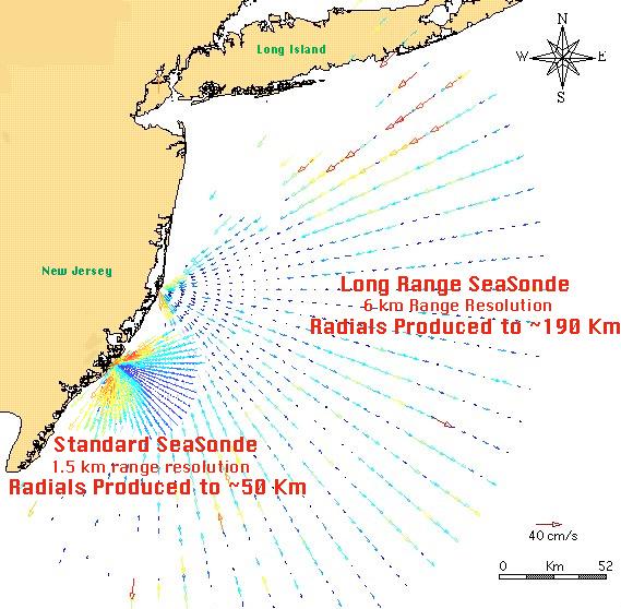
18 Combining all of this, we now can measure surface currents If we combine multiple CODAR sensors, we can measure the total surface current velocity Want the bearing angle to be as close to 90 degrees as possible (doesn t work for less than 20 degrees)
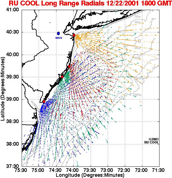
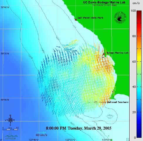
19 Example One of the most active centers for CODAR research is...
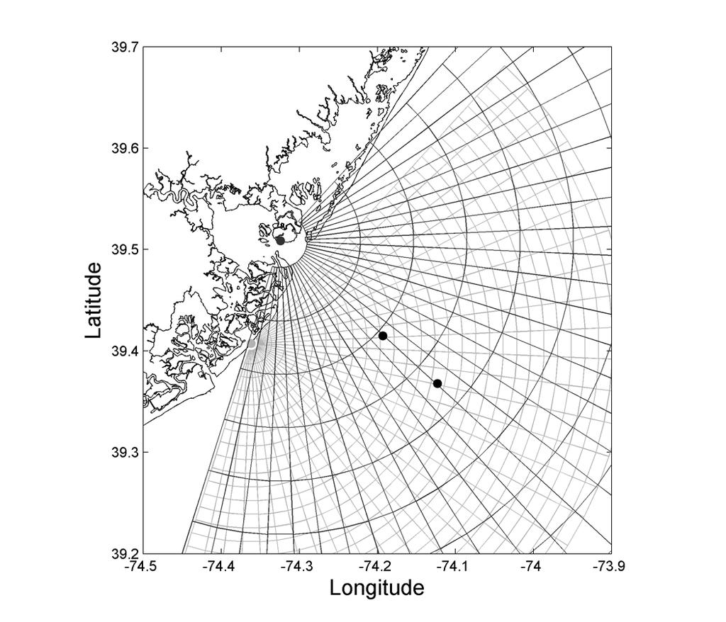
20 Example &$'()$!"*+,!""#$%!""#$& -&$'()$!"*+,!"#$%&'()'*+&'%,-",.'-,/,'#"%-0'12%'/+&'3456'070/&8'9-,%:'#%,7;',<-'/+&'(3'456'070/&8'
21 What can CODAR do for us?
22 What can CODAR do for us? Search and rescue: Probability of success is increased through the improvement in the estimation of search areas based on real time data and modelling. Marine protection: Hindcast and nowcast analysis of surface currents help to identify land and sea origin of spills and organize operations efficiently. Combined with other data sources and technologies (meteorology, satellite) and air and sea surveillance it helps to organise response in case of emergency or accident. Current data can be assimilated in all kind of forecast models. Safe navigation: HF Radar delivers data which are important for the development of crisis management studies and procedures. Decision support tools based on modelling and real time data can help to take objective decisions in crisis situation. Coastal engineering, fisheries and beach management: Coastal studies related to sediment transport, bloom events and water quality need surface current monitoring in order to improve the understanding of natural processes and take management decisions. Marine sciences: HF RADAR not only delivers current data but also wave parameters (significant wave height, period and direction). These data are integrated into long time databases which are available for multidisciplinary studies. Tsunami early warning: HF Radar is an integral part of Tsunami Early Warning Systems as a complement of seismographic information and DART buoys. Its contribution consists in the reliable identification of the Tsunami wave 100 km away from the coast based on its characteristic orbital velocity pattern.
23 Advantages of CODAR Very broad spatial coverage (360 degrees) Very long range Velocity measurements accurate to within 4 cm/s Cheap (when compared to satellites, anyway)
24 Limitations of CODAR Relies on theory (dispersion relation) Decreased range and resolution with frequency REALLY noisy
25 CODAR range and resolution Transmission Frequency 4-6 MHz Range km during daytime Resolution 3-12 km MHz km 2-3 km MHz km 1-2 km MHz km m 4-6 MHz range: There is a lot more background noise at night
26 Actual Mechanisms of CODAR First need to determine range to target (distance of the wave from the device) Then determine speed of target Then need to determine the direction in which the signal is traveling (along which radius the wave is traveling)
27 Range to Target Uses FM (frequency modulated) signal - frequency increases with time Can t just measure how long it takes for a wave to return back to the sensor
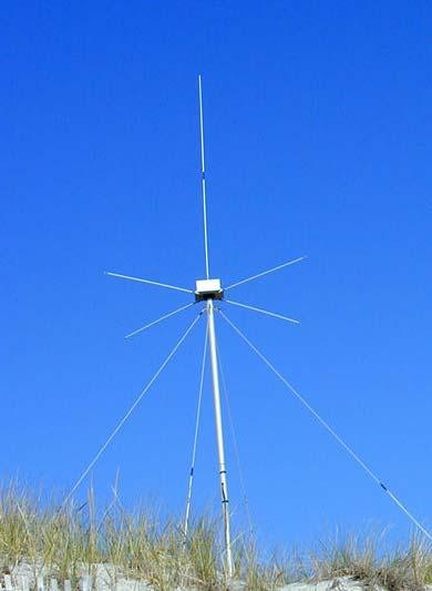
28 Speed of Target Doppler shift is calculated and averaged over ~4 minutes to give velocity accuracy to within 4 cm/s
29 Direction of Travel!"""#"""#"""!!"#$%&'()'*+&',-$%'.&//0'$0&1'"2'3+&'"23&%4-/53"-26''*+&"%'%&/53"7&'8&"#+30'5%&'"21".53&1' 8"3+"2'&5.+'.&//6'


30 History of HF Radar HF Radar -- Is It New Technology?! British 25-MHz "Chain Home" built 1938 to detect German bombers!! "Bragg" sea echo from English Channel mistakenly labeled "jammer" These systems preceded microwave radars by several years 380-foot tall metal transmit towers 240-foot tall wooden receive towers for further reading
 Example: 500-m half-rhombic array built by DoC (Barrick) in 1972 -- SCI, CA But Why HF?")
31 History of HF Radar The Beginnings Large Phased Arrays on San Clemente Island, CA Microwave vs. HF -- what's the difference?: (about three orders of magnitude!) Example: 500-m half-rhombic array built by DoC (Barrick) in SCI, CA But Why HF? Beyond the horizon Scatter from water waves is simple 1 billion microwave radars exist Only 300 HF radars exist in the world, 250 done by CODAR HF radars not good for much except sea scatter
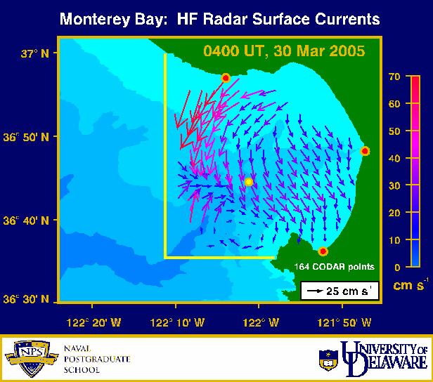
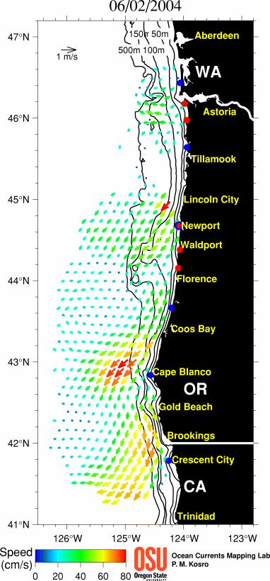
32 And now for some actual examples of CODAR...
33

34 Transmit Receive
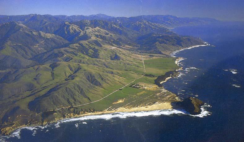
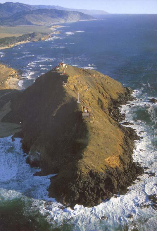
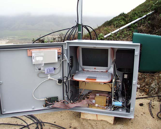
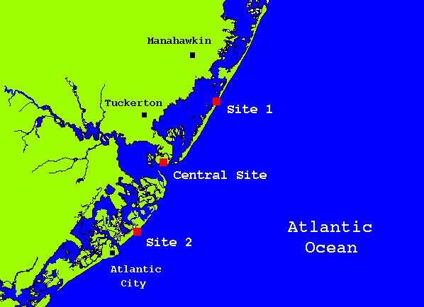
35 Pt Sur CODAR/SeaSonde

36 East Sea Site 2 Transmit Antenna

37 East Sea Site 2 ReceiveAntenna
38
39

40 Countries Presently Operating SeaSonde Networks United States Canada Mexico Brazil Norway Spain Portugal Italy Croatia Japan Korea China Taiwan India Egypt Israel Jordan Russia
 - 3 Data Nodes")
 - Design,")
41 National HF Radar Plan - Over 100 Sites Participating (including all 26 MARCOOS systems) - 3 Data Nodes (Rutgers, Scripps, NDBC) - NOAA IOOS to fund development of a National Plan (coordinated through ACT) - Design, Budget, Metrics
*+%,-..%,/01%2'&'\"*#%&'%.")
42 Hourly CODAR Current Maps of Hudson River Plume!"#$%$&'&%()*+%,-..%,/01%2'&'"*#%&'%.+3)*24%5"67'
43
44

45
46 A storm moving up the New Jersey coast on October 16, 2002


47 RUC Wind and Pressure Analysis Spatial Maps 10/16/ GMT CODAR Surface Currents 1002 mb Contour resolution 1 mb


48 10/16/ GMT RUC Wind and Pressure Analysis CODAR Surface Currents! 991 mb! Contour resolution 1 mb


49 10/16/ GMT RUC Wind and Pressure Analysis CODAR Surface Currents! 989 mb! Contour resolution 1 mb


50 10/17/ GMT RUC Wind and Pressure Analysis! 992 mb CODAR Surface Currents! Contour resolution 1 mb
51 Live Examples real_time_lr.html real_time_std.html
An Introduction to High Frequency Surface Wave Radar
 An Introduction to High Frequency Surface Wave Radar Dr. Hugh Roarty Dr. Scott Glenn Presented by: Trevor Bartleet (Peralex Electronics) The Radar Masters Course at UCT http://radarmasters.co.za/ Set up
Geometric Dilution of Precision of HF Radar Data in 2+ Station Networks. Heather Rae Riddles May 2, 2003
 Geometric Dilution of Precision of HF Radar Data in + Station Networks Heather Rae Riddles May, 003 Introduction The goal of this Directed Independent Study (DIS) is to provide a basic understanding of
Drift Ice Detection by HF radar off Mombetsu
 Drift Ice Detection by HF radar off Mombetsu 凘 氷解而流也 Wei Zhang 1, Naoto Ebuchi 1, Brian Emery 2 and Hiroto Abe 1 1 Institute of Low Temperature Science, Hokkaido University 1 2 Marine Science Institute,
The World s First Triple Nested HF Radar Test Bed for Current Mapping and Ship Detection
 The World s First Triple Nested HF Radar Test Bed for Current Mapping and Ship Detection Hugh Roarty Scott Glenn Josh Kohut Rutgers University Don Barrick Pam Kung CODAR Ocean Sensors FUTURE WORK (ROW4)
OC3570 PROJECT REPORT: A COMPARISON OF COASTAL CURRENTS USING LAND BASED HF RADAR AND SHIP BOARD ADCP OBSERVATIONS. LCDR Steve Wall, RAN Winter 2007
 OC3570 PROJECT REPORT: A COMPARISON OF COASTAL CURRENTS USING LAND BASED HF RADAR AND SHIP BOARD ADCP OBSERVATIONS LCDR Steve Wall, RAN Winter 2007 Background High Frequency (HF) radar between 3 and 30MHz
A Bistatic HF Radar for Current Mapping and Robust Ship Tracking
 A Bistatic HF Radar for Current Mapping and Robust Ship Tracking Dennis Trizna Imaging Science Research, Inc. V. 703-801-1417 dennis @ isr-sensing.com www.isr-sensing.com Objective: Develop methods for
C three decadesz'other reviews serve that purpose (e.g., Barrick, 1978;
 STATUS OF HF RADARS FOR WAVE-HEIGHT DIRECTIONAL SPECTRAL MEASUREMENTS - Donald E. Barrick 1 Introduction SThis manuscript is a concise review of the status of high-frequency (HF) radars for measuring various
SODAR- sonic detecting and ranging
 Active Remote Sensing of the PBL Immersed vs. remote sensors Active vs. passive sensors RADAR- radio detection and ranging WSR-88D TDWR wind profiler SODAR- sonic detecting and ranging minisodar RASS RADAR
Directional Wave Information from the SeaSonde PREPRINT
 Directional Wave Information from the SeaSonde PREPRINT Belinda Lipa Codar Ocean Sensors 25 La Sandra Way, Portola Valley 94028 Bruce Nyden Codar Ocean Sensors 00 Fremont Ave Suite 45, Los Altos, CA 94024
The HF oceanographic radar development in China. Wu Xiongbin School of Electronic Information Wuhan University
 The HF oceanographic radar development in China Wu Xiongbin School of Electronic Information Wuhan University xbwu@whu.edu.cn Outlines An overall introduction Development of the OSMAR HFSWR technique OSMAR
Microwave Sounding. Ben Kravitz October 29, 2009
 Microwave Sounding Ben Kravitz October 29, 2009 What is Microwave Sounding? Passive sensor in the microwave to measure temperature and water vapor Technique was pioneered by Ed Westwater (c. 1978) Microwave
David Franc. Department of Commerce Office of Radio Frequency Management
 David Franc Department of Commerce Office of Radio Frequency Management Oceanographic Radar Outline What It Does Some Examples What It Looks Like How It Works How Much It Costs Spectrum Considerations
APPLICATION OF OCEAN RADAR ON THE BALTIC, FEATURES AND LIMITATIONS
 APPLICATION OF OCEAN RADAR ON THE BALTIC, FEATURES AND LIMITATIONS Thomas Helzel, Matthias Kniephoff, Leif Petersen, Markus Valentin Helzel Messtechnik GmbH e-mail: helzel@helzel.com Presentation at Hydro
ELECTROMAGNETIC SPECTRUM ELECTROMAGNETIC SPECTRUM
 LECTURE:2 ELECTROMAGNETIC SPECTRUM ELECTROMAGNETIC SPECTRUM Electromagnetic waves: In an electromagnetic wave the electric and magnetic fields are mutually perpendicular. They are also both perpendicular
UNIT Derive the fundamental equation for free space propagation?
 UNIT 8 1. Derive the fundamental equation for free space propagation? Fundamental Equation for Free Space Propagation Consider the transmitter power (P t ) radiated uniformly in all the directions (isotropic),
HF-Radar Network Near-Real Time Ocean Surface Current Mapping
 HF-Radar Network Near-Real Time Ocean Surface Current Mapping The HF-Radar Network (HFRNet) acquires surface ocean radial velocities measured by HF-Radar through a distributed network and processes the
Directional Wave Information from the SeaSonde
 Directional Wave Information from the SeaSonde PREPRINT ACCEPTED FOR PUBLICATION IN IEEE JOE Belinda Lipa 1 Codar Ocean Sensors 125 La Sandra Way, Portola Valley 9428 Bruce Nyden Codar Ocean Sensors 1
Data and Computer Communications Chapter 4 Transmission Media
 Data and Computer Communications Chapter 4 Transmission Media Ninth Edition by William Stallings Data and Computer Communications, Ninth Edition by William Stallings, (c) Pearson Education - Prentice Hall,
HF Radar Sea-echo from Shallow Water
 Sensors 2008, 8, 1-x manuscripts; DOI: 10.3390/sensors Research Paper OPEN ACCESS sensors ISSN 1424-8220 www.mdpi.org/sensors HF Radar Sea-echo from Shallow Water B.J. Lipa*1, B.B. Nyden2, D. E. Barrick2
Concept Design of Space-Borne Radars for Tsunami Detection
 Concept Design of Space-Borne Radars for Tsunami Detection DLR German Aerospace Agency +Microwaves and Radar Institute *Remote Sensing Institute +Michele Galletti +Gerhard Krieger +Nicolas Marquart +Thomas
THE NATURE OF GROUND CLUTTER AFFECTING RADAR PERFORMANCE MOHAMMED J. AL SUMIADAEE
 International Journal of Electronics, Communication & Instrumentation Engineering Research and Development (IJECIERD) ISSN(P): 2249-684X; ISSN(E): 2249-7951 Vol. 6, Issue 2, Apr 2016, 7-14 TJPRC Pvt. Ltd.
Lecture 12: Curvature and Refraction Radar Equation for Point Targets (Rinehart Ch3-4)
") MET 4410 Remote Sensing: Radar and Satellite Meteorology MET 5412 Remote Sensing in Meteorology Lecture 12: Curvature and Refraction Radar Equation for Point Targets (Rinehart Ch3-4) Radar Wave Propagation
MET 4410 Remote Sensing: Radar and Satellite Meteorology MET 5412 Remote Sensing in Meteorology Lecture 12: Curvature and Refraction Radar Equation for Point Targets (Rinehart Ch3-4) Radar Wave Propagation
WiFi Lab Division C Team #
 Team Name: Team Number: Student Names: & Directions: You will be given up to 30 minutes to complete the following written test on topics related to Radio Antennas, as described in the official rules. Please
Technical and operational characteristics of oceanographic radars operating in sub-bands within the frequency range 3-50 MHz
 Recommendation ITU-R M.1874-1 (02/2013) Technical and operational characteristics of oceanographic radars operating in sub-bands within the frequency range 3-50 MHz M Series Mobile, radiodetermination,
HF RADAR DETECTS AN APPROACHING TSUNAMI WAVE ALREADY IN DEEP WATERS
 HF RADAR HF RADAR DETECTS AN APPROACHING TSUNAMI WAVE ALREADY IN DEEP WATERS Long-Lih Huang 1, Anna Dzvonkovskaya 2, Mal Heron 3 1 All-Star-Technology Co., Taipei, Taiwan 2 Helzel Messtechnik GmbH, Kaltenkirchen,
Section 1 Wireless Transmission
 Part : Wireless Communication! section : Wireless Transmission! Section : Digital modulation! Section : Multiplexing/Medium Access Control (MAC) Section Wireless Transmission Intro. to Wireless Transmission
Assessment of HF Radar for Significant Wave Height Determination. Desmond Power VP, Remote Sensing, C-CORE
 Assessment of HF Radar for Significant Wave Height Determination Desmond Power VP, Remote Sensing, C-CORE Study Rationale Agenda Technology Overview Technology Assessment for CNLOPB Proposed Go Forward
Profiling River Surface Velocities and Volume Flow Estmation with Bistatic UHF RiverSonde Radar
 Profiling River Surface Velocities and Volume Flow Estmation with Bistatic UHF RiverSonde Radar Don Barrick Ralph Cheng Cal Teague Jeff Gartner Pete Lilleboe U.S. Geological Survey CODAR Ocean Sensors,
Coherent Marine Radar. Measurements of Ocean Wave Spectra and Surface Currents
 Measurements of Ocean Wave Spectra and Surface Currents Dennis Trizna Imaging Science Research, Inc. dennis @ isr-sensing.com Presentation Outline: Introduction: Standard Marine Radar vs. Single Image
Accuracy of surface current velocity measurements obtained from HF radar along the east coast of Korea
 Accuracy of surface current velocity measurements obtained from HF radar along the east coast of Korea Hanna Na, Kuh Kim and Kyung-Il Chang School of Earth and Environmental Sciences/ Research Institute
RF noise and interference within the ITU bands the ACORN experience
 RF noise and interference within the ITU bands the ACORN experience Simone Cosoli School of Civil, Environmental and Mining Engineering The UWA Oceans Institute The University of Western Australia Outline
Microwave Remote Sensing
 Provide copy on a CD of the UCAR multi-media tutorial to all in class. Assign Ch-7 and Ch-9 (for two weeks) as reading material for this class. HW#4 (Due in two weeks) Problems 1,2,3 and 4 (Chapter 7)
Radar. Seminar report. Submitted in partial fulfillment of the requirement for the award of degree Of Mechanical
 A Seminar report on Radar Submitted in partial fulfillment of the requirement for the award of degree Of Mechanical SUBMITTED TO: SUBMITTED BY: www.studymafia.org www.studymafia.org Preface I have made
Final Examination. 22 April 2013, 9:30 12:00. Examiner: Prof. Sean V. Hum. All non-programmable electronic calculators are allowed.
 UNIVERSITY OF TORONTO FACULTY OF APPLIED SCIENCE AND ENGINEERING The Edward S. Rogers Sr. Department of Electrical and Computer Engineering ECE 422H1S RADIO AND MICROWAVE WIRELESS SYSTEMS Final Examination
Co-ReSyF RA lecture: Vessel detection and oil spill detection
 This project has received funding from the European Union s Horizon 2020 Research and Innovation Programme under grant agreement no 687289 Co-ReSyF RA lecture: Vessel detection and oil spill detection
Sources of Geographic Information
 Sources of Geographic Information Data properties: Spatial data, i.e. data that are associated with geographic locations Data format: digital (analog data for traditional paper maps) Data Inputs: sampled
Why Ice Detection Radar?
 Past, Present and Future of Ice Radar Detection System in Prince William Sound by Joel Kennedy and Tom Kuckertz Why Ice Detection Radar? Exxon Valdez Spill Overseas Ohio collides with iceberg and suffers
A Matlab-Based Virtual Propagation Tool: Surface Wave Mixed-path Calculator
 430 Progress In Electromagnetics Research Symposium 2006, Cambridge, USA, March 26-29 A Matlab-Based Virtual Propagation Tool: Surface Wave Mixed-path Calculator L. Sevgi and Ç. Uluışık Doğuş University,
Recent Developments in NOAA s Real- Time Coastal Observing Systems for Safe and Efficient Maritime Transportation
 Recent Developments in NOAA s Real- Time Coastal Observing Systems for Safe and Efficient Maritime Transportation Rich Edwing, Director NOAA Center for Operational Oceanographic Products and Services CMTS
Port Security and Technology - the U.S. Perspective. Michael S. Bruno Stevens Institute of Technology March 14, 2012
 Port Security and Technology - the U.S. Perspective Michael S. Bruno Stevens Institute of Technology March 14, 2012 CSR A Department of Homeland Security National Center of Excellence for Port Security
Mobile Wireless Communications - Overview
 S. R. Zinka srinivasa_zinka@daiict.ac.in October 16, 2014 First of all... Which frequencies we can use for wireless communications? Atmospheric Attenuation of EM Waves 100 % Gamma rays, X-rays and ultraviolet
Remote Sensing: John Wilkin IMCS Building Room 211C ext 251. Active microwave systems (1) Satellite Altimetry
 Satellite Altimetry") Remote Sensing: John Wilkin wilkin@marine.rutgers.edu IMCS Building Room 211C 732-932-6555 ext 251 Active microwave systems (1) Satellite Altimetry Active microwave instruments Scatterometer (scattering
Remote Sensing: John Wilkin wilkin@marine.rutgers.edu IMCS Building Room 211C 732-932-6555 ext 251 Active microwave systems (1) Satellite Altimetry Active microwave instruments Scatterometer (scattering
THANK YOU. The Helzel Messtechnik Team would like to say
 The Helzel Messtechnik Team would like to say THANK YOU 2008 to all business partners, friends and colleagues for the faithful co-operation, support and exchange in 2007. We would be pleased to continue
Getting a feel for HF coastal radar
 Monitoring enhancement Getting a feel for HF coastal radar Pia Andersson Philip Axe In the early days The influence of ocean waves on HF radar backscatter was reported by Crombie in 1955. He examined the
SATELLITE OCEANOGRAPHY
 SATELLITE OCEANOGRAPHY An Introduction for Oceanographers and Remote-sensing Scientists I. S. Robinson Lecturer in Physical Oceanography Department of Oceanography University of Southampton JOHN WILEY
A bluffer s guide to Radar
 A bluffer s guide to Radar Andy French December 2009 We may produce at will, from a sending station, an electrical effect in any particular region of the globe; (with which) we may determine the relative
Antenna & Propagation. Basic Radio Wave Propagation
 For updated version, please click on http://ocw.ump.edu.my Antenna & Propagation Basic Radio Wave Propagation by Nor Hadzfizah Binti Mohd Radi Faculty of Electric & Electronics Engineering hadzfizah@ump.edu.my
MODIFYING AND IMPLEMENTING AN INVERSION ALGORITHM FOR WAVES FROM A BROAD-BEAM HF RADAR NETWORK
 MODIFYING AND IMPLEMENTING AN INVERSION ALGORITHM FOR WAVES FROM A BROAD-BEAM HF RADAR NETWORK Elizabeth Ann Livermont, Jon K. Miller, and Thomas O. Herrington Davidson Laboratory: Stevens Institute of
Test results of Array Type HF Radar in the eastern coast of Korea
 Test results of Array Type HF Radar in the eastern coast of Korea Seung Bea Choi 1, Hyeon Seong Kim 1, Jong Yoon Moon 1, Kang Ho Lee 1, Isamu Ogasawara 2 and Matthias Kniephoff 3 1 Marine Information Technology,
Mapping Surface Currents Around U.S. Coasts
 Mapping Surface Currents Around U.S. Coasts A Network of High-Frequency Radar for the Integrated Ocean Observing System By Dr. Eric J. Terrill Director Mark Otero Programmer/Analyst and Lisa Hazard Operations
William Stallings Data and Computer Communications 7 th Edition. Chapter 4 Transmission Media
 William Stallings Data and Computer Communications 7 th Edition Chapter 4 Transmission Media Overview Guided - wire Unguided - wireless Characteristics and quality determined by medium and signal For guided,
Unguided Media and Matched Filter After this lecture, you will be able to Example?
 Unguided Media and Matched Filter After this lecture, you will be able to describe the physical and transmission characteristics of various unguided media Example? B.1 Unguided media Guided to unguided
SeaSonde Measurements in COPE-3
 SeaSonde Measurements in COPE-3 Jeffrey D. Paduan Department of Oceanography, Code OC/Pd Naval Postgraduate School Monterey, CA 93943 phone: (831) 656-3350; fax: (831) 656-2712; email: paduan@nps.navy.mil
Argo. 1,000m: drift approx. 9 days. Total cycle time: 10 days. Float transmits data to users via satellite. Descent to depth: 6 hours
 Float transmits data to users via satellite Total cycle time: 10 days Descent to depth: 6 hours 1,000m: drift approx. 9 days Temperature and salinity profiles are recorded during ascent: 6 hours Float
AGF-216. The Earth s Ionosphere & Radars on Svalbard
 AGF-216 The Earth s Ionosphere & Radars on Svalbard Katie Herlingshaw 07/02/2018 1 Overview Radar basics what, how, where, why? How do we use radars on Svalbard? What is EISCAT and what does it measure?
The Los Alamos Dual Band Lightning Array: A new tool for mapping VLF and VHF lightning in the Gulf of Mexico
 The Los Alamos Dual Band Lightning Array: A new tool for mapping VLF and VHF lightning in the Gulf of Mexico Can we probe D-region disturbances using lightning? Christopher A. Jeffery (cjeffery@lanl.gov)
Deriving meteorological observations from intercepted Mode-S EHS messages.
 Deriving meteorological observations from intercepted Mode-S EHS messages. Edmund Keith Stone and Malcolm Kitchen July 28, 2016 Abstract The Met Office has deployed a network of five receivers in the UK
Lecture 1 INTRODUCTION. Dr. Aamer Iqbal Bhatti. Radar Signal Processing 1. Dr. Aamer Iqbal Bhatti
 Lecture 1 INTRODUCTION 1 Radar Introduction. A brief history. Simplified Radar Block Diagram. Two basic Radar Types. Radar Wave Modulation. 2 RADAR The term radar is an acronym for the phrase RAdio Detection
(A) 2f (B) 2 f (C) f ( D) 2 (E) 2
 2f (B) 2 f (C) f ( D) 2 (E) 2") 1. A small vibrating object S moves across the surface of a ripple tank producing the wave fronts shown above. The wave fronts move with speed v. The object is traveling in what direction and with what
1. A small vibrating object S moves across the surface of a ripple tank producing the wave fronts shown above. The wave fronts move with speed v. The object is traveling in what direction and with what
ASEASONDE is a high-frequency (HF) radar system with a
 radar system with a") 850 IEEE JOURNAL OF OCEANIC ENGINEERING, VOL. 31, NO. 4, OCTOBER 2006 SeaSonde Radial Velocities: Derivation and Internal Consistency Belinda Lipa, Bruce Nyden, David S. Ullman, and Eric Terrill Abstract
850 IEEE JOURNAL OF OCEANIC ENGINEERING, VOL. 31, NO. 4, OCTOBER 2006 SeaSonde Radial Velocities: Derivation and Internal Consistency Belinda Lipa, Bruce Nyden, David S. Ullman, and Eric Terrill Abstract
Get Discount Coupons for your Coaching institute and FREE Study Material at COMMUNICATION SYSTEMS
 COMMUNICATION SYSTEMS 1. BASICS OF COMMUNICATION 2. AMPLITUDE MODULATION Get Discount Coupons for your Coaching institute and FREE Study Material at www.pickmycoaching.com 1 BASICS OF COMMUNICATION 1.
Electromagnetic (Light) Waves Electromagnetic Waves
 Waves Electromagnetic Waves") Physics R Date: Review Questions 1. An ocean wave traveling at 3 m/s has a wavelength of 1.6 meters. a. What is the frequency of the wave? b. What is the period of the wave? Electromagnetic (Light) Waves
Physics R Date: Review Questions 1. An ocean wave traveling at 3 m/s has a wavelength of 1.6 meters. a. What is the frequency of the wave? b. What is the period of the wave? Electromagnetic (Light) Waves
Microwave Remote Sensing (1)
") Microwave Remote Sensing (1) Microwave sensing encompasses both active and passive forms of remote sensing. The microwave portion of the spectrum covers the range from approximately 1cm to 1m in wavelength.
Microwave Remote Sensing (1) Microwave sensing encompasses both active and passive forms of remote sensing. The microwave portion of the spectrum covers the range from approximately 1cm to 1m in wavelength.
Chapter 8. Remote sensing
 1. Remote sensing 8.1 Introduction 8.2 Remote sensing 8.3 Resolution 8.4 Landsat 8.5 Geostationary satellites GOES 8.1 Introduction What is remote sensing? One can describe remote sensing in different
Active microwave systems (1) Satellite Altimetry
 Satellite Altimetry") Remote Sensing: John Wilkin Active microwave systems (1) Satellite Altimetry jwilkin@rutgers.edu IMCS Building Room 214C 732-932-6555 ext 251 Active microwave instruments Scatterometer (scattering from
Remote Sensing: John Wilkin Active microwave systems (1) Satellite Altimetry jwilkin@rutgers.edu IMCS Building Room 214C 732-932-6555 ext 251 Active microwave instruments Scatterometer (scattering from
OVERVIEW OF RADOME AND OPEN ARRAY RADAR TECHNOLOGIES FOR WATERBORNE APPLICATIONS INFORMATION DOCUMENT
 OVERVIEW OF RADOME AND OPEN ARRAY RADAR TECHNOLOGIES FOR WATERBORNE APPLICATIONS INFORMATION DOCUMENT Copyright notice The copyright of this document is the property of KELVIN HUGHES LIMITED. The recipient
6/20/2012 ACORN ACORN ACORN ACORN ACORN ACORN. Arnstein Prytz. Australian Coastal Ocean Radar Network (ACORN)
") The Australian Coastal Ocean Radar Network WERA Processing and Quality Control Arnstein Prytz Australian Coastal Ocean Radar Network Marine Geophysical Laboratory School of Earth and Environmental Sciences
The Australian Coastal Ocean Radar Network WERA Processing and Quality Control Arnstein Prytz Australian Coastal Ocean Radar Network Marine Geophysical Laboratory School of Earth and Environmental Sciences
HF Radar Measurements of Ocean Surface Currents and Winds
 HF Radar Measurements of Ocean Surface Currents and Winds John F. Vesecky Electrical Engineering Department, University of California at Santa Cruz 221 Baskin Engineering, 1156 High Street, Santa Cruz
Satellite Navigation (and positioning)
") Satellite Navigation (and positioning) Picture: ESA AE4E08 Instructors: Sandra Verhagen, Hans van der Marel, Christian Tiberius Course 2010 2011, lecture 1 Today s topics Course organisation Course contents
Satellite Navigation (and positioning) Picture: ESA AE4E08 Instructors: Sandra Verhagen, Hans van der Marel, Christian Tiberius Course 2010 2011, lecture 1 Today s topics Course organisation Course contents
DEFINING FIRST-ORDER REGION BOUNDARIES Mar 5, 2002
 DEFINING FIRST-ORDER REGION BOUNDARIES Mar 5, 2002 One of the most critical features of SeaSonde analysis is the empirical determination of the frequencies that define the Bragg (first-order) region. In
Cost Effective Control of your Coastal Waters
 Cost Effective Control of your Coastal Waters Olov Fäst SSC Airborne Systems 2013-07-03 SSC: A comprehensive space industry Founded in 1972 ~650 employees (2012) ~100 M turnover (2012) Since the start
RADIOMETRIC TRACKING. Space Navigation
 RADIOMETRIC TRACKING Space Navigation Space Navigation Elements SC orbit determination Knowledge and prediction of SC position & velocity SC flight path control Firing the attitude control thrusters to
GOCI Status and Cooperation with CoastColour Project
 GOCI Status and Cooperation with CoastColour Project Joo-Hyung RYU Contribution from : KOSC colleaques Nov. 17, 2010 World 1 st GOCI/COMS Launch Campaign Launch Date : June 27 2010 Launch Vehicle : Ariane-V
Dual Use Multi-Frequency Radar For Current Shear Mapping and Ship Target Classification
 Dual Use Multi-Frequency Radar For Current Shear Mapping and Ship Target Classification Dennis B. Trizna, Ph. D. Imaging Science Research, Inc. 9310A Old Keene Mill Road Burke, VA 22015 V 703 801-1417,
UNDER STANDING RADIO FREQUENCY Badger Meter, Inc.
 UNDER STANDING RADIO FREQUENCY UNDERSTANDING RADIO FREQUENCY Regional Sales Meeting March 1-2, 2011 Brian Fiut Sr. Product Manager Itron Inc. Liberty Lake, WA August 25, 2010 RADIO PROPAGATION Radio consists
Information furnished in conformity with the Convention on Registration of Objects Launched into Outer Space
 United Nations Secretariat Distr.: General 9 September 2003 Original: English Committee on the Peaceful Uses of Outer Space Information furnished in conformity with the Convention on Registration of Objects
Chapter1: Introduction, Aims and Objectives
 Chapter 1: Introduction, Aims and Objectives 1 Chapter1: Introduction, Aims and Objectives 1.1 Introduction Recent advances in remote sensing technology have led to expanding applications in environmental
Fundamental Concepts of Radar
 Fundamental Concepts of Radar Dr Clive Alabaster & Dr Evan Hughes White Horse Radar Limited Contents Basic concepts of radar Detection Performance Target parameters measurable by a radar Primary/secondary
Radio Communication. Presentation created by: András Balogh
 Radio Communication Presentation created by: András Balogh AM and FM The goal is to transmit a modulating signal S(t) via a wave sin(ωt). In case of AM, the product of the modulation is f(t)=(a+s(t))*sin(ωt);
Next Generation Operational Met Office Weather Radars and Products
 Next Generation Operational Met Office Weather Radars and Products Pierre TABARY Jacques PARENT-DU-CHATELET Observing Systems Dept. Météo France Toulouse, France pierre.tabary@meteo.fr WakeNet Workshop,
RADARSAT-2 Program Update Daniel De Lisle Canadian Space Agency
 RADARSAT-2 Program Update Daniel De Lisle Canadian Space Agency Presentation outline RADARSAT-1 Update RADARSAT-2 Mission description Mission Objectives System Characteristics Data Commercialization/Allocation
Radio Merit Badge Boy Scouts of America
 Radio Merit Badge Boy Scouts of America Module 1 - Radio Basics BSA National Radio Scouting Committee 2012. Purpose Make You a Radio Expert Basic Familiarity With Radio Emergency Preparedness.. Class Format
NETW 701: Wireless Communications. Lecture 5. Small Scale Fading
 NETW 701: Wireless Communications Lecture 5 Small Scale Fading Small Scale Fading Most mobile communication systems are used in and around center of population. The transmitting antenna or Base Station
Validation of significant wave height product from Envisat ASAR using triple collocation
 IOP Conference Series: Earth and Environmental Science OPEN ACCESS Validation of significant wave height product from Envisat using triple collocation To cite this article: H Wang et al 014 IOP Conf. Ser.:
27/11/2013' OCEANOGRAPHIC APPLICATIONS. Acoustic Current Meters
 egm502 seafloor mapping lecture 17 water column applications OCEANOGRAPHIC APPLICATIONS Acoustic Current Meters An acoustic current meter is a set of transducers fixed in a frame. Acoustic current meters
LECTURE 20 ELECTROMAGNETIC WAVES. Instructor: Kazumi Tolich
 LECTURE 20 ELECTROMAGNETIC WAVES Instructor: Kazumi Tolich Lecture 20 2 25.6 The photon model of electromagnetic waves 25.7 The electromagnetic spectrum Radio waves and microwaves Infrared, visible light,
Nearshore Applications of Marine Radar
 Nearshore Applications of Marine Radar JD Lentine 15 June 2006 A project in fulfillment of the Master s of Science in Civil Engineering, Oregon State University Table of Contents 1. Introduction Research
Class Overview. Antenna Fundamentals Repeaters Duplex and Simplex Nets and Frequencies Cool Radio Functions Review
 Class Overview Antenna Fundamentals Repeaters Duplex and Simplex Nets and Frequencies Cool Radio Functions Review Antennas Antennas An antenna is a device used for converting electrical currents into electromagnetic
Chapter 1: Telecommunication Fundamentals
 Chapter 1: Telecommunication Fundamentals Block Diagram of a communication system Noise n(t) m(t) Information (base-band signal) Signal Processing Carrier Circuits s(t) Transmission Medium r(t) Signal
RADAR DEVELOPMENT BASIC CONCEPT OF RADAR WAS DEMONSTRATED BY HEINRICH. HERTZ VERIFIED THE MAXWELL RADAR.
 1 RADAR WHAT IS RADAR? RADAR (RADIO DETECTION AND RANGING) IS A WAY TO DETECT AND STUDY FAR OFF TARGETS BY TRANSMITTING A RADIO PULSE IN THE DIRECTION OF THE TARGET AND OBSERVING THE REFLECTION OF THE
Wave Sensing Radar and Wave Reconstruction
 Applied Physical Sciences Corp. 475 Bridge Street, Suite 100, Groton, CT 06340 (860) 448-3253 www.aphysci.com Wave Sensing Radar and Wave Reconstruction Gordon Farquharson, John Mower, and Bill Plant (APL-UW)
KONGSBERG SATELLITE SERVICES 2017 Line Steinbakk, Director Programs. Himmel og hav - Ålesund 3. Oktober 2017
 KONGSBERG SATELLITE SERVICES 2017 Line Steinbakk, Director Programs Himmel og hav - Ålesund 3. Oktober 2017 KSAT HQ IN TROMSØ 69N Established in 1967 Kongsberg Satellite Services since 2002 World leading
Lecture Outlines Chapter 25. Physics, 3 rd Edition James S. Walker
 Lecture Outlines Chapter 25 Physics, 3 rd Edition James S. Walker 2007 Pearson Prentice Hall This work is protected by United States copyright laws and is provided solely for the use of instructors in
Australian Wind Profiler Network and Data Use in both Operational and Research Environments
 Australian Wind Profiler Network and Data Use in both Operational and Research Environments Bronwyn Dolman 1,2 and Iain Reid 1,2 1 ATRAD Pty Ltd 20 Phillips St Thebarton South Australia www.atrad.com.au
RADAR CHAPTER 3 RADAR
 RADAR CHAPTER 3 RADAR RDF becomes Radar 1. As World War II approached, scientists and the military were keen to find a method of detecting aircraft outside the normal range of eyes and ears. They found
Design of an Airborne SLAR Antenna at X-Band
 Design of an Airborne SLAR Antenna at X-Band Markus Limbach German Aerospace Center (DLR) Microwaves and Radar Institute Oberpfaffenhofen WFMN 2007, Markus Limbach, Folie 1 Overview Applications of SLAR
A Terrestrial Multiple-Receiver Radio Link Experiment at 10.7 GHz - Comparisons of Results with Parabolic Equation Calculations
 RADIOENGINEERING, VOL. 19, NO. 1, APRIL 2010 117 A Terrestrial Multiple-Receiver Radio Link Experiment at 10.7 GHz - Comparisons of Results with Parabolic Equation Calculations Pavel VALTR 1, Pavel PECHAC
Optics & Light. See What I m Talking About. Grade 8 - Science OPTICS - GRADE 8 SCIENCE 1
 Optics & Light See What I m Talking About Grade 8 - Science OPTICS - GRADE 8 SCIENCE 1 Overview In this cluster, students broaden their understanding of how light is produced, transmitted, and detected.
ECEN 4634/5634, MICROWAVE AND RF LABORATORY
 ECEN 4634/5634, MICROWAVE AND RF LABORATORY Final Exam December 18, 2017 7:30-10:00pm 150 minutes, closed book, 1 sheet allowed, no calculators (estimates need to be within 3dB) Part 1 (60%). Briefly answer
Microwaves. Group 7, 11/22/2013
 Microwaves Group 7, 11/22/2013 Matthew Spickard History/Definition Andrew Miller Range of practical application Dustin Morris Detailed application and equation definition History First predicted by James