The HF oceanographic radar development in China. Wu Xiongbin School of Electronic Information Wuhan University
|
|
|
- Jasper Richard
- 5 years ago
- Views:
Transcription


1 The HF oceanographic radar development in China Wu Xiongbin School of Electronic Information Wuhan University
2 Outlines An overall introduction Development of the OSMAR HFSWR technique OSMAR tests and applications Problems and future work
3 Introduction China started the HFSWR (High-Frequency Surface Wave Radar) technology studies on sea state surveillance since 1980 s. Harbin Institute of Technology Wuhan University East China Normal University Xidian University Supported by the National Natural Science Foundation of China the China National 863 High Technique Project
4 Introduction More than 15 HFSWR stations are now operating along the China coastlines Managed by the State Oceanic Administration (SOA) the China Meteorological Administration (CMA)

5 Wuhan University ~ HF Radar? Routine Ionosphere observation began since Independently reported the discovery of Equatorial Anomaly on Nature in Developed series of ionosphere probing equipments in China. Ionosphere probing equipments work in HF band. Actually they are HF radars. OSMAR(Ocean State Monitoring & Analyzing Radar) appears naturally when the antenna beam of an ionosphere HF radar is turned from sky to ocean.


6 Development of the OSMAR HFSWR technique The Space Physics Department of Wuhan University started the OSMAR series HFSWR development since the late 1980s. The first prototype OSMAR was tested at the coast of Guangxi Province in Motivated by the early CODAR 4-element system.


7 Development of the OSMAR HFSWR technique 200km-coverage OSMAR 7.5MHz FMICW waveform three intermediate frequency conversion superheterodyne structure a three-element Yagi transmitting antenna a receiving array composed of eight linearly-deployed dipole antennas MUSIC for currents DBF for wind and wave information
 type database")
8 Development of the OSMAR HFSWR technique Latest OSMAR product features: automatically calibration of amplitude and phase mismatch between channels. allowing alternatively frequencychanging among FMICW sweeping frames full digital receiver techniques software: C/S (Client/Server) type database architecture

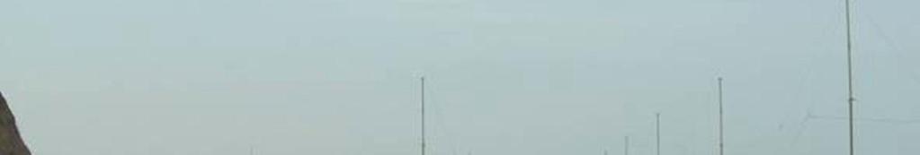
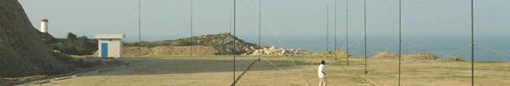

9 Longhai OSMAR Site

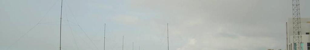


10 Dongshan OSMAR Site


11 A-scope display of sea echoes


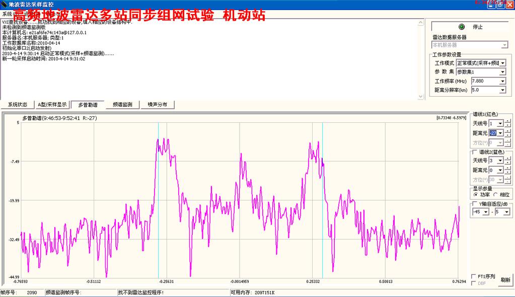
12 Doppler spectra of sea echoes

13 Radio spectrum surveillance

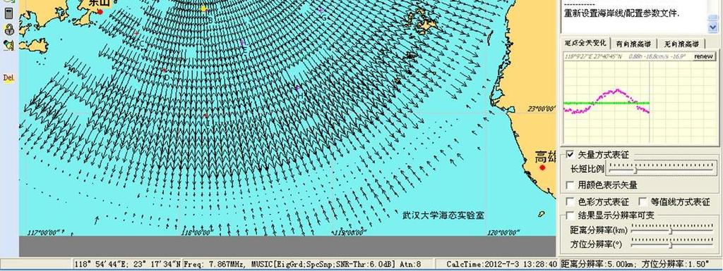
14 Radial current field

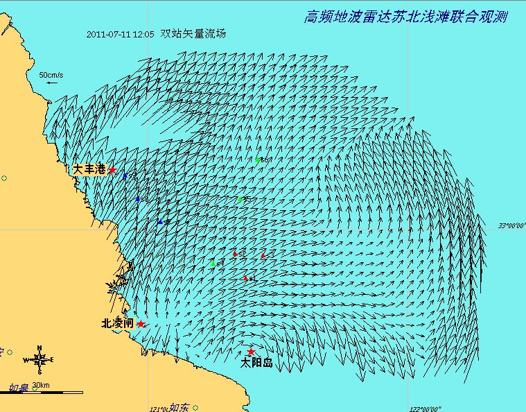
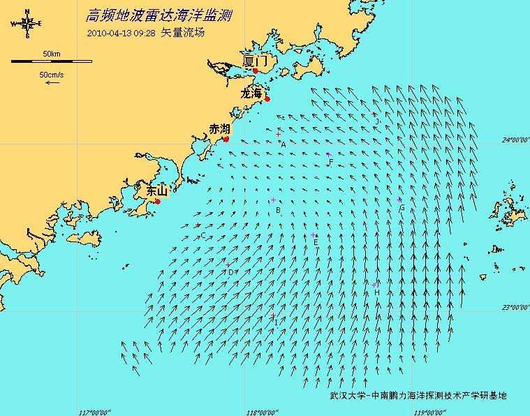
15 Vector current field

16 Vector current field


17 OSMAR Results Wind field Wave field Doppler Spectra 2 s 谱值 /m Wave Spectra from inversion Current field 频率 /Hz
18 OSMAR tests and applications Verification tests conclusions: (1) temporal and spatial stable surface current field (such as tide field) can be detected by HFSWR with quite high accuracy and reliability; (2) results from different systems demonstrate different temporal and spatial resolution; (3) dynamics inversed from the echoes second order Doppler spectra (such as wave height, wind velocity, etc.) show poor quality and low reliability compared with current information which is extracted from the first order peaks
19 OSMAR tests and applications The work of OSMAR data quality control and feasibility of using these data in oceanographic studies are organized and lead by scholars in Xiamen University. (Zhu D., et al, The Taiwan Straight, 2006)
20 OSMAR tests and applications Long time-series of OSMAR surface current data sets were used to decompose the surface current in western part of the Taiwan Strait, and it was found that the surface current there contains mainly two parts: the seasonal variation of the along-shore currents induced by the monsoon and an all-year-long persistent background northeast flow of about 10cm/s. 10cm/s along shore Current when there is no wind stress (Zhu D., et al, Chinese Science Bulletin, 2008)
21 OSMAR tests and applications The OSMAR sea surface current data was assimilated into a parallelly computing 3-D numerical oceanic prediction model in the Taiwan Strait together with other multi-sensor ocean data using 4D Variational Data Assimilation method, the errors between predicted and observed data were reduced as much as 32.4% and thus the prediction was greatly improved. SST RMSE. (Zhang, Ph.D Thesis, 2009) HF Radar current RMSE
 was revealed and new drag coefficient for regional numerical model was proposed. (Wu X. and Li Y.")
22 OSMAR tests and applications The bottom drag coefficient has been estimated from the HF-radar current flow, the drag reduction trend over periodic bathymetry (sand waves) was revealed and new drag coefficient for regional numerical model was proposed. (Wu X. and Li Y., 1 st ORCA, 2012)
23 HFSWR shoal floor topography Deep Water Shallow Water V p = (g / k 0 ) 1/2 V p = (g tanh(k 0 h) / k 0 ) 1/2 h radio / 4 h < radio / 4


24 ~8.6,Wuhan Univ.,Xiamen Univ. and Nanjing Univ.


25 Beilingzha Site


26 Taiyangsha Site
27 Dafenggang Site
28

29 Result of shoal floor topography (Li Yan, Zhong Yaozhao, 2012)
30 Problems and future work For low HF band radar systems, which are designed to cover more than 100km range, are exposed to intensive natural or artificial radio interferences and noises in the southern China coast areas, thus data quality is hard to be maintained. Missing of large current information. Applicability to temporally or spatially complicated currents. Inversion difficulties concerning about wave and wind field.

31 HFSWR network test

32
A new fully-digital HF radar system for oceanographical remote sensing
 LETTER IEICE Electronics Express, Vol.10, No.14, 1 6 A new fully-digital HF radar system for oceanographical remote sensing Yingwei Tian 1a), Biyang Wen 1b),JianTan 1,KeLi 1, Zhisheng Yan 2, and Jing Yang
Ionospheric effect of HF surface wave over-the-horizon radar
 RADIO SCIENCE, VOL. 41,, doi:10.1029/2005rs003323, 2006 Ionospheric effect of HF surface wave over-the-horizon radar Huotao Gao, 1 Geyang Li, 1 Yongxu Li, 1 Zijie Yang, 1 and Xiongbin Wu 1 Received 25
A Bistatic HF Radar for Current Mapping and Robust Ship Tracking
 A Bistatic HF Radar for Current Mapping and Robust Ship Tracking Dennis Trizna Imaging Science Research, Inc. V. 703-801-1417 dennis @ isr-sensing.com www.isr-sensing.com Objective: Develop methods for
Dual Use Multi-Frequency Radar For Current Shear Mapping and Ship Target Classification
 Dual Use Multi-Frequency Radar For Current Shear Mapping and Ship Target Classification Dennis B. Trizna, Ph. D. Imaging Science Research, Inc. 9310A Old Keene Mill Road Burke, VA 22015 V 703 801-1417,
David Franc. Department of Commerce Office of Radio Frequency Management
 David Franc Department of Commerce Office of Radio Frequency Management Oceanographic Radar Outline What It Does Some Examples What It Looks Like How It Works How Much It Costs Spectrum Considerations
CODAR. Ben Kravitz September 29, 2009
 CODAR Ben Kravitz September 29, 2009 Outline What is CODAR? Doppler shift Bragg scatter How CODAR works What CODAR can tell us What is CODAR? Coastal Ocean Dynamics Application Radar Land-based HF radar
SATELLITE OCEANOGRAPHY
 SATELLITE OCEANOGRAPHY An Introduction for Oceanographers and Remote-sensing Scientists I. S. Robinson Lecturer in Physical Oceanography Department of Oceanography University of Southampton JOHN WILEY
HF RADAR DETECTS AN APPROACHING TSUNAMI WAVE ALREADY IN DEEP WATERS
 HF RADAR HF RADAR DETECTS AN APPROACHING TSUNAMI WAVE ALREADY IN DEEP WATERS Long-Lih Huang 1, Anna Dzvonkovskaya 2, Mal Heron 3 1 All-Star-Technology Co., Taipei, Taiwan 2 Helzel Messtechnik GmbH, Kaltenkirchen,
Drift Ice Detection by HF radar off Mombetsu
 Drift Ice Detection by HF radar off Mombetsu 凘 氷解而流也 Wei Zhang 1, Naoto Ebuchi 1, Brian Emery 2 and Hiroto Abe 1 1 Institute of Low Temperature Science, Hokkaido University 1 2 Marine Science Institute,
Assessment of HF Radar for Significant Wave Height Determination. Desmond Power VP, Remote Sensing, C-CORE
 Assessment of HF Radar for Significant Wave Height Determination Desmond Power VP, Remote Sensing, C-CORE Study Rationale Agenda Technology Overview Technology Assessment for CNLOPB Proposed Go Forward
Geometric Dilution of Precision of HF Radar Data in 2+ Station Networks. Heather Rae Riddles May 2, 2003
 Geometric Dilution of Precision of HF Radar Data in + Station Networks Heather Rae Riddles May, 003 Introduction The goal of this Directed Independent Study (DIS) is to provide a basic understanding of
Quantifying and Reducing the DOA Estimation Error Resulting from Antenna Pattern Deviation for Direction-Finding HF Radar
 remote sensing Article Quantifying and Reducing the DOA Estimation Error Resulting from Antenna Pattern Deviation for Direction-Finding HF Radar Yeping Lai, Hao Zhou * ID, Yuming Zeng and Biyang Wen The
Technical and operational characteristics of oceanographic radars operating in sub-bands within the frequency range 3-50 MHz
 Recommendation ITU-R M.1874-1 (02/2013) Technical and operational characteristics of oceanographic radars operating in sub-bands within the frequency range 3-50 MHz M Series Mobile, radiodetermination,
6/20/2012 ACORN ACORN ACORN ACORN ACORN ACORN. Arnstein Prytz. Australian Coastal Ocean Radar Network (ACORN)
") The Australian Coastal Ocean Radar Network WERA Processing and Quality Control Arnstein Prytz Australian Coastal Ocean Radar Network Marine Geophysical Laboratory School of Earth and Environmental Sciences
The Australian Coastal Ocean Radar Network WERA Processing and Quality Control Arnstein Prytz Australian Coastal Ocean Radar Network Marine Geophysical Laboratory School of Earth and Environmental Sciences
Remote Sensing: John Wilkin IMCS Building Room 211C ext 251. Active microwave systems (1) Satellite Altimetry
 Satellite Altimetry") Remote Sensing: John Wilkin wilkin@marine.rutgers.edu IMCS Building Room 211C 732-932-6555 ext 251 Active microwave systems (1) Satellite Altimetry Active microwave instruments Scatterometer (scattering
Remote Sensing: John Wilkin wilkin@marine.rutgers.edu IMCS Building Room 211C 732-932-6555 ext 251 Active microwave systems (1) Satellite Altimetry Active microwave instruments Scatterometer (scattering
Coherent Marine Radar. Measurements of Ocean Wave Spectra and Surface Currents
 Measurements of Ocean Wave Spectra and Surface Currents Dennis Trizna Imaging Science Research, Inc. dennis @ isr-sensing.com Presentation Outline: Introduction: Standard Marine Radar vs. Single Image
GNSS Ocean Reflected Signals
 GNSS Ocean Reflected Signals Per Høeg DTU Space Technical University of Denmark Content Experimental setup Instrument Measurements and observations Spectral characteristics, analysis and retrieval method
OC3570 PROJECT REPORT: A COMPARISON OF COASTAL CURRENTS USING LAND BASED HF RADAR AND SHIP BOARD ADCP OBSERVATIONS. LCDR Steve Wall, RAN Winter 2007
 OC3570 PROJECT REPORT: A COMPARISON OF COASTAL CURRENTS USING LAND BASED HF RADAR AND SHIP BOARD ADCP OBSERVATIONS LCDR Steve Wall, RAN Winter 2007 Background High Frequency (HF) radar between 3 and 30MHz
C three decadesz'other reviews serve that purpose (e.g., Barrick, 1978;
 STATUS OF HF RADARS FOR WAVE-HEIGHT DIRECTIONAL SPECTRAL MEASUREMENTS - Donald E. Barrick 1 Introduction SThis manuscript is a concise review of the status of high-frequency (HF) radars for measuring various
High Resolution Ocean Radar Observations in Ports and Harbours
 High Resolution Ocean Radar Observations in Ports and Harbours M.L. Heron 1,2, A. Prytz 2 and C. Steinberg 1,3 1 AIMS@JCU; 2 School of Environmental and Earth Sciences, James Cook University, Townsville,
CHAPTER 1 INTRODUCTION
 1 CHAPTER 1 INTRODUCTION In maritime surveillance, radar echoes which clutter the radar and challenge small target detection. Clutter is unwanted echoes that can make target detection of wanted targets
HF-Radar Network Near-Real Time Ocean Surface Current Mapping
 HF-Radar Network Near-Real Time Ocean Surface Current Mapping The HF-Radar Network (HFRNet) acquires surface ocean radial velocities measured by HF-Radar through a distributed network and processes the
Active microwave systems (1) Satellite Altimetry
 Satellite Altimetry") Remote Sensing: John Wilkin Active microwave systems (1) Satellite Altimetry jwilkin@rutgers.edu IMCS Building Room 214C 732-932-6555 ext 251 Active microwave instruments Scatterometer (scattering from
Remote Sensing: John Wilkin Active microwave systems (1) Satellite Altimetry jwilkin@rutgers.edu IMCS Building Room 214C 732-932-6555 ext 251 Active microwave instruments Scatterometer (scattering from
Operation of a Mobile Wind Profiler In Severe Clutter Environments
 1. Introduction Operation of a Mobile Wind Profiler In Severe Clutter Environments J.R. Jordan, J.L. Leach, and D.E. Wolfe NOAA /Environmental Technology Laboratory Boulder, CO Wind profiling radars have
Microwave Sensors Subgroup (MSSG) Report
 Report") Microwave Sensors Subgroup (MSSG) Report Feb 17-20, 2014, ESA ESRIN, Frascati, Italy DONG, Xiaolong, MSSG Chair National Space Science Center Chinese Academy of Sciences (MiRS,NSSC,CAS) Email: dongxiaolong@mirslab.cn
Microwave Sensors Subgroup (MSSG) Report Feb 17-20, 2014, ESA ESRIN, Frascati, Italy DONG, Xiaolong, MSSG Chair National Space Science Center Chinese Academy of Sciences (MiRS,NSSC,CAS) Email: dongxiaolong@mirslab.cn
Directional Wave Information from the SeaSonde PREPRINT
 Directional Wave Information from the SeaSonde PREPRINT Belinda Lipa Codar Ocean Sensors 25 La Sandra Way, Portola Valley 94028 Bruce Nyden Codar Ocean Sensors 00 Fremont Ave Suite 45, Los Altos, CA 94024
Accuracy of surface current velocity measurements obtained from HF radar along the east coast of Korea
 Accuracy of surface current velocity measurements obtained from HF radar along the east coast of Korea Hanna Na, Kuh Kim and Kyung-Il Chang School of Earth and Environmental Sciences/ Research Institute
The World s First Triple Nested HF Radar Test Bed for Current Mapping and Ship Detection
 The World s First Triple Nested HF Radar Test Bed for Current Mapping and Ship Detection Hugh Roarty Scott Glenn Josh Kohut Rutgers University Don Barrick Pam Kung CODAR Ocean Sensors FUTURE WORK (ROW4)
Estimation and Assessment of Errors Related to Antenna Pattern Distortion in CODAR SeaSonde High-Frequency Radar Ocean Current Measurements
 JUNE 2010 L A W S E T A L. 1029 Estimation and Assessment of Errors Related to Antenna Pattern Distortion in CODAR SeaSonde High-Frequency Radar Ocean Current Measurements KENNETH LAWS University of California,
SODAR- sonic detecting and ranging
 Active Remote Sensing of the PBL Immersed vs. remote sensors Active vs. passive sensors RADAR- radio detection and ranging WSR-88D TDWR wind profiler SODAR- sonic detecting and ranging minisodar RASS RADAR
MODIFYING AND IMPLEMENTING AN INVERSION ALGORITHM FOR WAVES FROM A BROAD-BEAM HF RADAR NETWORK
 MODIFYING AND IMPLEMENTING AN INVERSION ALGORITHM FOR WAVES FROM A BROAD-BEAM HF RADAR NETWORK Elizabeth Ann Livermont, Jon K. Miller, and Thomas O. Herrington Davidson Laboratory: Stevens Institute of
Test results of Array Type HF Radar in the eastern coast of Korea
 Test results of Array Type HF Radar in the eastern coast of Korea Seung Bea Choi 1, Hyeon Seong Kim 1, Jong Yoon Moon 1, Kang Ho Lee 1, Isamu Ogasawara 2 and Matthias Kniephoff 3 1 Marine Information Technology,
Directional Wave Information from the SeaSonde
 Directional Wave Information from the SeaSonde PREPRINT ACCEPTED FOR PUBLICATION IN IEEE JOE Belinda Lipa 1 Codar Ocean Sensors 125 La Sandra Way, Portola Valley 9428 Bruce Nyden Codar Ocean Sensors 1
Chapter1: Introduction, Aims and Objectives
 Chapter 1: Introduction, Aims and Objectives 1 Chapter1: Introduction, Aims and Objectives 1.1 Introduction Recent advances in remote sensing technology have led to expanding applications in environmental
Digital Sounder: HF Diagnostics Module:Ionosonde Dual Channel ( ) Eight Channel ( )
 Eight Channel ( )") CENTER FOR REMOTE SE NSING, INC. Digital Sounder: HF Diagnostics Module:Ionosonde Dual Channel (001-2000) Eight Channel (004-2006) 2010 Center for Remote Sensing, Inc. All specifications subject to change
CENTER FOR REMOTE SE NSING, INC. Digital Sounder: HF Diagnostics Module:Ionosonde Dual Channel (001-2000) Eight Channel (004-2006) 2010 Center for Remote Sensing, Inc. All specifications subject to change
Acoustic Monitoring of Flow Through the Strait of Gibraltar: Data Analysis and Interpretation
 Acoustic Monitoring of Flow Through the Strait of Gibraltar: Data Analysis and Interpretation Peter F. Worcester Scripps Institution of Oceanography, University of California at San Diego La Jolla, CA
Fundamental Concepts of Radar
 Fundamental Concepts of Radar Dr Clive Alabaster & Dr Evan Hughes White Horse Radar Limited Contents Basic concepts of radar Detection Performance Target parameters measurable by a radar Primary/secondary
APPLICATION OF OCEAN RADAR ON THE BALTIC, FEATURES AND LIMITATIONS
 APPLICATION OF OCEAN RADAR ON THE BALTIC, FEATURES AND LIMITATIONS Thomas Helzel, Matthias Kniephoff, Leif Petersen, Markus Valentin Helzel Messtechnik GmbH e-mail: helzel@helzel.com Presentation at Hydro
7A.6 HYBRID SCAN AND JOINT SIGNAL PROCESSING FOR A HIGH EFFICIENCY MPAR
 7A.6 HYBRID SCAN AND JOINT SIGNAL PROCESSING FOR A HIGH EFFICIENCY MPAR Guifu Zhang *, Dusan Zrnic 2, Lesya Borowska, and Yasser Al-Rashid 3 : University of Oklahoma 2: National Severe Storms Laboratory
Radar Environment RF Generation. Dr. Steffen Heuel Technology Manager Aerospace & Defense Rohde & Schwarz Munich, Germany
 Radar Environment RF Generation Dr. Steffen Heuel Technology Manager Aerospace & Defense Rohde & Schwarz Munich, Germany Typical navigation radar scenario Turning navigation radar antenna Tx Tx Tx Tx Rx
Research on HF Radio Propagation on the Sea by Machine Learning Optimized Model
 IOP Conference Series: Earth and Environmental Science PAPER OPEN ACCESS Research on HF Radio Propagation on the Sea by Machine Learning Optimized Model To cite this article: Yining Song et al 2018 IOP
Ship echo discrimination in HF radar sea-clutter
 Ship echo discrimination in HF radar sea-clutter A. Bourdillon (), P. Dorey () and G. Auffray () () Université de Rennes, IETR/UMR CNRS 664, Rennes Cedex, France () ONERA, DEMR/RHF, Palaiseau, France.
Analysis of South China Sea Shelf and Basin Acoustic Transmission Data
 DISTRIBUTION STATEMENT A: Distribution approved for public release; distribution is unlimited. Analysis of South China Sea Shelf and Basin Acoustic Transmission Data Ching-Sang Chiu Department of Oceanography
China. France Oceanography S A T. Overview of the near-real time wave products of the CFOSAT mission. e l l i t e
 China Overview of the near-real time wave products of the CFOSAT mission C. Tison (1), D. Hauser (2), S. Guibert (1), T. Amiot (1), L. Aouf (3), J.M. Lefèvre (3), B. Chapron (5), N. Corcoral (1), P. Castillan
DEFINING FIRST-ORDER REGION BOUNDARIES Mar 5, 2002
 DEFINING FIRST-ORDER REGION BOUNDARIES Mar 5, 2002 One of the most critical features of SeaSonde analysis is the empirical determination of the frequencies that define the Bragg (first-order) region. In
GNSS Reflectometry and Passive Radar at DLR
 ACES and FUTURE GNSS-Based EARTH OBSERVATION and NAVIGATION 26./27. May 2008, TU München Dr. Thomas Börner, Microwaves and Radar Institute, DLR Overview GNSS Reflectometry a joined proposal of DLR and
Results of GPR survey of AGH University of Science and Technology test site (Cracow neighborhood).
.") Results of GPR survey of AGH University of Science and Technology test site (Cracow neighborhood). October 02, 2017 Two GPR sets were used for the survey. First GPR set: low-frequency GPR Loza-N [1]. Technical
Results of GPR survey of AGH University of Science and Technology test site (Cracow neighborhood). October 02, 2017 Two GPR sets were used for the survey. First GPR set: low-frequency GPR Loza-N [1]. Technical
HIGH-FREQUENCY ACOUSTIC PROPAGATION IN THE PRESENCE OF OCEANOGRAPHIC VARIABILITY
 HIGH-FREQUENCY ACOUSTIC PROPAGATION IN THE PRESENCE OF OCEANOGRAPHIC VARIABILITY M. BADIEY, K. WONG, AND L. LENAIN College of Marine Studies, University of Delaware Newark DE 19716, USA E-mail: Badiey@udel.edu
A Bistatic HF Radar for Current Mapping and Robust Ship Tracking
 A Bistatic HF Radar for Current Mapping and Robust Ship Tracking D. B. Trizna Imaging Science Research, Inc. 6103B Virgo Court Burke, VA, 22015 USA Abstract- A bistatic HF radar has been developed for
1. Explain how Doppler direction is identified with FMCW radar. Fig Block diagram of FM-CW radar. f b (up) = f r - f d. f b (down) = f r + f d
 = f r - f d. f b (down) = f r + f d") 1. Explain how Doppler direction is identified with FMCW radar. A block diagram illustrating the principle of the FM-CW radar is shown in Fig. 4.1.1 A portion of the transmitter signal acts as the reference
1. Explain how Doppler direction is identified with FMCW radar. A block diagram illustrating the principle of the FM-CW radar is shown in Fig. 4.1.1 A portion of the transmitter signal acts as the reference
The Normal Baseline. Dick Gent Law of the Sea Division UK Hydrographic Office
 The Normal Baseline Dick Gent Law of the Sea Division UK Hydrographic Office 2 The normal baseline for measuring the breadth of the territorial sea is the low water line along the coast as marked on large
Remote Sensing: John Wilkin IMCS Building Room 211C ext 251. Active microwave systems (1) Satellite Altimetry
 Satellite Altimetry") Remote Sensing: John Wilkin wilkin@marine.rutgers.edu IMCS Building Room 211C 732-932-6555 ext 251 Active microwave systems (1) Satellite Altimetry Active microwave instruments Scatterometer (scattering
Remote Sensing: John Wilkin wilkin@marine.rutgers.edu IMCS Building Room 211C 732-932-6555 ext 251 Active microwave systems (1) Satellite Altimetry Active microwave instruments Scatterometer (scattering
QUALITY ISSUES IN RADAR WIND PROFILER
 QUALITY ISSUES IN RADAR WIND PROFILER C.Abhishek 1, S.Chinmayi 2, N.V.A.Sridhar 3, P.R.S.Karthikeya 4 1,2,3,4 B.Tech(ECE) Student, SCSVMV University Kanchipuram(India) ABSTRACT The paper discusses possible
Active microwave systems (2) Satellite Altimetry * range data processing * applications
 Satellite Altimetry * range data processing * applications") Remote Sensing: John Wilkin wilkin@marine.rutgers.edu IMCS Building Room 211C 732-932-6555 ext 251 Active microwave systems (2) Satellite Altimetry * range data processing * applications Satellite Altimeters
Remote Sensing: John Wilkin wilkin@marine.rutgers.edu IMCS Building Room 211C 732-932-6555 ext 251 Active microwave systems (2) Satellite Altimetry * range data processing * applications Satellite Altimeters
SeaSonde Measurements in COPE-3
 SeaSonde Measurements in COPE-3 Jeffrey D. Paduan Department of Oceanography, Code OC/Pd Naval Postgraduate School Monterey, CA 93943 phone: (831) 656-3350; fax: (831) 656-2712; email: paduan@nps.navy.mil
Australian Wind Profiler Network and Data Use in both Operational and Research Environments
 Australian Wind Profiler Network and Data Use in both Operational and Research Environments Bronwyn Dolman 1,2 and Iain Reid 1,2 1 ATRAD Pty Ltd 20 Phillips St Thebarton South Australia www.atrad.com.au
Table 1 The wheel-set security system of China high-speed railway
 11th European Conference on Non-Destructive Testing (ECNDT 2014), October 6-10, 2014, Prague, Czech Republic More Info at Open Access Database www.ndt.net/?id=16352 Dynamic ultrasonic inspection technology
A STUDY OF DOPPLER BEAM SWINGING USING AN IMAGING RADAR
 .9O A STUDY OF DOPPLER BEAM SWINGING USING AN IMAGING RADAR B. L. Cheong,, T.-Y. Yu, R. D. Palmer, G.-F. Yang, M. W. Hoffman, S. J. Frasier and F. J. López-Dekker School of Meteorology, University of Oklahoma,
Sea Surface Echoes Observed with the MU Radar under Intense Sporadic E Conditions. Tadahiko OGAwA1, Mamoru YAMAMOTO2, and Shoichiro FUKA02
 Letter J. Geomaq. Geoelectr., 48, 447-451, 1996 Sea Surface Echoes Observed with the MU Radar under Intense Sporadic E Conditions Tadahiko OGAwA1, Mamoru YAMAMOTO2, and Shoichiro FUKA02 1Solar-Terrestrial
Getting a feel for HF coastal radar
 Monitoring enhancement Getting a feel for HF coastal radar Pia Andersson Philip Axe In the early days The influence of ocean waves on HF radar backscatter was reported by Crombie in 1955. He examined the
MULTI-TEMPORAL SATELLITE IMAGES WITH BATHYMETRY CORRECTION FOR MAPPING AND ASSESSING SEAGRASS BED CHANGES IN DONGSHA ATOLL
 MULTI-TEMPORAL SATELLITE IMAGES WITH BATHYMETRY CORRECTION FOR MAPPING AND ASSESSING SEAGRASS BED CHANGES IN DONGSHA ATOLL Chih -Yuan Lin and Hsuan Ren Center for Space and Remote Sensing Research, National
Lecture Topics. Doppler CW Radar System, FM-CW Radar System, Moving Target Indication Radar System, and Pulsed Doppler Radar System
 Lecture Topics Doppler CW Radar System, FM-CW Radar System, Moving Target Indication Radar System, and Pulsed Doppler Radar System 1 Remember that: An EM wave is a function of both space and time e.g.
ASEASONDE is a high-frequency (HF) radar system with a
 radar system with a") 850 IEEE JOURNAL OF OCEANIC ENGINEERING, VOL. 31, NO. 4, OCTOBER 2006 SeaSonde Radial Velocities: Derivation and Internal Consistency Belinda Lipa, Bruce Nyden, David S. Ullman, and Eric Terrill Abstract
850 IEEE JOURNAL OF OCEANIC ENGINEERING, VOL. 31, NO. 4, OCTOBER 2006 SeaSonde Radial Velocities: Derivation and Internal Consistency Belinda Lipa, Bruce Nyden, David S. Ullman, and Eric Terrill Abstract
Tracking of Moving Targets with MIMO Radar
 Tracking of Moving Targets with MIMO Radar Peter W. Moo, Zhen Ding Radar Sensing & Exploitation Section DRDC Ottawa Research Centre Presentation to 2017 NATO Military Sensing Symposium 31 May 2017 waveform
Microwave Sensors Subgroup (MSSG) Report
 Report") Microwave Sensors Subgroup (MSSG) Report CEOS WGCV-35 May 13-17, 2013, Shanghai, China DONG, Xiaolong, MSSG Chair CAS Key Laboratory of Microwave Remote Sensing National Space Science Center Chinese Academy
Microwave Sensors Subgroup (MSSG) Report CEOS WGCV-35 May 13-17, 2013, Shanghai, China DONG, Xiaolong, MSSG Chair CAS Key Laboratory of Microwave Remote Sensing National Space Science Center Chinese Academy
NEW STRATOSPHERE-TROPOSPHERE RADAR WIND PROFILER FOR NATIONAL NETWORKS AND RESEARCH
 NEW STRATOSPHERE-TROPOSPHERE RADAR WIND PROFILER FOR NATIONAL NETWORKS AND RESEARCH Scott A. McLaughlin, Bob L. Weber, David A. Merritt, Gary A. Zimmerman, Maikel L. Wise, Frank Pratte DeTect, Inc. 117-L
Estimation of Ocean Current Velocity near Incheon using Radarsat-1 SAR and HF-radar Data
 Korean Journal of Remote Sensing, Vol.23, No.5, 2007, pp.421~430 Estimation of Ocean Current Velocity near Incheon using Radarsat-1 SAR and HF-radar Data Moon-Kyung Kang and Hoonyol Lee Department of Geophysics,
Next Generation Operational Met Office Weather Radars and Products
 Next Generation Operational Met Office Weather Radars and Products Pierre TABARY Jacques PARENT-DU-CHATELET Observing Systems Dept. Météo France Toulouse, France pierre.tabary@meteo.fr WakeNet Workshop,
Rec. ITU-R F RECOMMENDATION ITU-R F *
 Rec. ITU-R F.162-3 1 RECOMMENDATION ITU-R F.162-3 * Rec. ITU-R F.162-3 USE OF DIRECTIONAL TRANSMITTING ANTENNAS IN THE FIXED SERVICE OPERATING IN BANDS BELOW ABOUT 30 MHz (Question 150/9) (1953-1956-1966-1970-1992)
RECOMMENDATION ITU-R BS.80-3 * Transmitting antennas in HF broadcasting
 Rec. ITU-R BS.80-3 1 RECOMMENDATION ITU-R BS.80-3 * Transmitting antennas in HF broadcasting (1951-1978-1986-1990) The ITU Radiocommunication Assembly, considering a) that a directional transmitting antenna
Active Cancellation Algorithm for Radar Cross Section Reduction
 International Journal of Computational Engineering Research Vol, 3 Issue, 7 Active Cancellation Algorithm for Radar Cross Section Reduction Isam Abdelnabi Osman, Mustafa Osman Ali Abdelrasoul Jabar Alzebaidi
ELECTROMAGNETIC PROPAGATION (ALT, TEC)
") ELECTROMAGNETIC PROPAGATION (ALT, TEC) N. Picot CNES, 18 Av Ed Belin, 31401 Toulouse, France Email : Nicolas.Picot@cnes.fr ABSTRACT For electromagnetic propagation, the ionosphere plays a key role. This
ELECTROMAGNETIC PROPAGATION (ALT, TEC) N. Picot CNES, 18 Av Ed Belin, 31401 Toulouse, France Email : Nicolas.Picot@cnes.fr ABSTRACT For electromagnetic propagation, the ionosphere plays a key role. This
Influence of Vibration of Tail Platform of Hydropower Station on Transformer Performance
 Influence of Vibration of Tail Platform of Hydropower Station on Transformer Performance Hao Liu a, Qian Zhang b School of Mechanical and Electronic Engineering, Shandong University of Science and Technology,
Intelligence Based Tracking for Two Radar Applications
 Zhen Ding 1, Derek Yee 2, Tony Ponsford 2 and Peter Moo 1 1 Radar Sensing & Exploitation Section Defence R&D Canada Ottawa, Ontario, Canada, K1A 0Z4 2 Raytheon Canada Ltd. Waterloo, Ontario, Canada, N2J
Report ITU-R M.2234 (11/2011)
") Report ITU-R M.2234 (11/2011) The feasibility of sharing sub-bands between oceanographic radars operating in the radiolocation service and fixed and mobile services within the frequency band 3-50 MHz M
Report ITU-R M.2234 (11/2011) The feasibility of sharing sub-bands between oceanographic radars operating in the radiolocation service and fixed and mobile services within the frequency band 3-50 MHz M
HF Radar Measurements of Ocean Surface Currents and Winds
 HF Radar Measurements of Ocean Surface Currents and Winds John F. Vesecky Electrical Engineering Department, University of California at Santa Cruz 221 Baskin Engineering, 1156 High Street, Santa Cruz
Lecture 3 SIGNAL PROCESSING
 Lecture 3 SIGNAL PROCESSING Pulse Width t Pulse Train Spectrum of Pulse Train Spacing between Spectral Lines =PRF -1/t 1/t -PRF/2 PRF/2 Maximum Doppler shift giving unambiguous results should be with in
Altimeter Range Corrections
 Altimeter Range Corrections Schematic Summary Corrections Altimeters Range Corrections Altimeter range corrections can be grouped as follows: Atmospheric Refraction Corrections Sea-State Bias Corrections
Microwave Remote Sensing (1)
") Microwave Remote Sensing (1) Microwave sensing encompasses both active and passive forms of remote sensing. The microwave portion of the spectrum covers the range from approximately 1cm to 1m in wavelength.
Microwave Remote Sensing (1) Microwave sensing encompasses both active and passive forms of remote sensing. The microwave portion of the spectrum covers the range from approximately 1cm to 1m in wavelength.
Know how Pulsed Doppler radar works and how it s able to determine target velocity. Know how the Moving Target Indicator (MTI) determines target
 determines target") Moving Target Indicator 1 Objectives Know how Pulsed Doppler radar works and how it s able to determine target velocity. Know how the Moving Target Indicator (MTI) determines target velocity. Be able to
Moving Target Indicator 1 Objectives Know how Pulsed Doppler radar works and how it s able to determine target velocity. Know how the Moving Target Indicator (MTI) determines target velocity. Be able to
A new Sensor for the detection of low-flying small targets and small boats in a cluttered environment
 UNCLASSIFIED /UNLIMITED Mr. Joachim Flacke and Mr. Ryszard Bil EADS Defence & Security Defence Electronics Naval Radar Systems (OPES25) Woerthstr 85 89077 Ulm Germany joachim.flacke@eads.com / ryszard.bil@eads.com
Dynasonde measurements advance understanding of the thermosphereionosphere
 Dynasonde measurements advance understanding of the thermosphereionosphere dynamics Nikolay Zabotin 1 with contributions from Oleg Godin 2, Catalin Negrea 1,4, Terence Bullett 3,5, Liudmila Zabotina 1
Artificial Ionospheric Perturbations Studied During НААRP May-June 2014 campaign
 Artificial Ionospheric Perturbations Studied During НААRP May-June 2014 campaign E.N. Sergeev 1,2, A.V. Shindin 1, S.M. Grach 1, G.M. Milikh 3 1 Lobachevsky State University of Nizhni Novgorod, Gagarin
DETECTION OF SMALL AIRCRAFT WITH DOPPLER WEATHER RADAR
 DETECTION OF SMALL AIRCRAFT WITH DOPPLER WEATHER RADAR Svetlana Bachmann 1, 2, Victor DeBrunner 3, Dusan Zrnic 2 1 Cooperative Institute for Mesoscale Meteorological Studies, The University of Oklahoma
A Full-Solid-Angle Scanning Planar Phased Array
 Forum for Electromagnetic Research Methods and Application Technologies (FERMAT) A Full-Solid-Angle Scanning Planar Phased Array Zixuan Yi, and Qi Zhu Key Laboratory of Electromagnetic Space Information,
Maximum Usable Frequency
 Maximum Usable Frequency 15 Frequency (MHz) 10 5 0 Maximum Usable Frequency Usable Frequency Window Lowest Usable Frequency Solar Flare 6 12 18 24 Time (Hours) Radio Blackout Usable Frequency Window Ken
Validation of significant wave height product from Envisat ASAR using triple collocation
 IOP Conference Series: Earth and Environmental Science OPEN ACCESS Validation of significant wave height product from Envisat using triple collocation To cite this article: H Wang et al 014 IOP Conf. Ser.:
Artificial Ionospheric Perturbations Studied During НААRP May-June 2014 campaign
 Artificial Ionospheric Perturbations Studied During НААRP May-June 2014 campaign E.N. Sergeev 1,2, A.V. Shindin 1, S.M. Grach 1, G.M. Milikh 3 1 Lobachevsky State University of Nizhni Novgorod, Gagarin
Radar-Verfahren und -Signalverarbeitung
 Radar-Verfahren und -Signalverarbeitung - Lesson 2: RADAR FUNDAMENTALS I Hon.-Prof. Dr.-Ing. Joachim Ender Head of Fraunhoferinstitut für Hochfrequenzphysik and Radartechnik FHR Neuenahrer Str. 20, 53343
HF Radar Sea-echo from Shallow Water
 Sensors 2008, 8, 1-x manuscripts; DOI: 10.3390/sensors Research Paper OPEN ACCESS sensors ISSN 1424-8220 www.mdpi.org/sensors HF Radar Sea-echo from Shallow Water B.J. Lipa*1, B.B. Nyden2, D. E. Barrick2
Intercomparison of a WaveGuide radar and two Directional Waveriders
 Introduction T. van der Vlugt Radac Zomerluststraat LM Haarlem The Netherlands email: tom@radac.nl Down-looking FMCW radars for wave measurements are in use already for years. They have Intercomparison
THE NATURE OF GROUND CLUTTER AFFECTING RADAR PERFORMANCE MOHAMMED J. AL SUMIADAEE
 International Journal of Electronics, Communication & Instrumentation Engineering Research and Development (IJECIERD) ISSN(P): 2249-684X; ISSN(E): 2249-7951 Vol. 6, Issue 2, Apr 2016, 7-14 TJPRC Pvt. Ltd.
Daily and seasonal variations of TID parameters over the Antarctic Peninsula
 Daily and seasonal variations of TID parameters over the Antarctic Peninsula A. Zalizovski 1, Y. Yampolski 1, V. Paznukhov 2, E. Mishin 3, A. Sopin 1 1. Institute of Radio Astronomy, National Academy of
Monitoring the polar cap/ auroral ionosphere: Industrial applications. P. T. Jayachandran Physics Department University of New Brunswick Fredericton
 Monitoring the polar cap/ auroral ionosphere: Industrial applications P. T. Jayachandran Physics Department University of New Brunswick Fredericton Outline Ionosphere and its effects on modern and old
A bluffer s guide to Radar
 A bluffer s guide to Radar Andy French December 2009 We may produce at will, from a sending station, an electrical effect in any particular region of the globe; (with which) we may determine the relative
Design and Simulation of Dipole and Cable-Fed Network of TD-SCDMA Smart Antenna 1
 2009 International Conference on Communications and Mobile Computing Design and Simulation of Dipole and Cable-Fed Network of TD-SCDMA Smart Antenna 1 Maowen Wang 1, Yejun He 1,2,3, Guangxi Zhu 2, Deming
4-3-2 Renewal of the Radars of Rainfall Information System: Tokyo Amesh
 4-3-2 Renewal of the Radars of Rainfall Information System: Tokyo Amesh Tadahisa KOBUNA, Yoshinori YABUKI Staff Member and Senior Staff, Facilities Management Section, Facilities Management and Maintenance
Detection and Characterization of Travelling Ionospheric Disturbances Using a compact GPS network
 Detection and Characterization of Travelling Ionospheric Disturbances Using a compact GPS network Dr. Richard Penney Joseph Reid Dr. Natasha Jackson-Booth Luke Selzer 1 Overview Compact GPS network in
STM Product Evolution for Processing Baseline 2.24
 PREPARATION AND OPERATIONS OF THE MISSION PERFORMANCE CENTRE (MPC) FOR THE COPERNICUS SENTINEL-3 MISSION Contract: 4000111836/14/I-LG Customer: ESA Document Contract No.: 4000111836/14/I-LG Project: PREPARATION
Prototype Software-based Receiver for Remote Sensing using Reflected GPS Signals. Dinesh Manandhar The University of Tokyo
 Prototype Software-based Receiver for Remote Sensing using Reflected GPS Signals Dinesh Manandhar The University of Tokyo dinesh@qzss.org 1 Contents Background Remote Sensing Capability System Architecture