Accuracy of surface current velocity measurements obtained from HF radar along the east coast of Korea
|
|
|
- Rafe Brooks
- 5 years ago
- Views:
Transcription
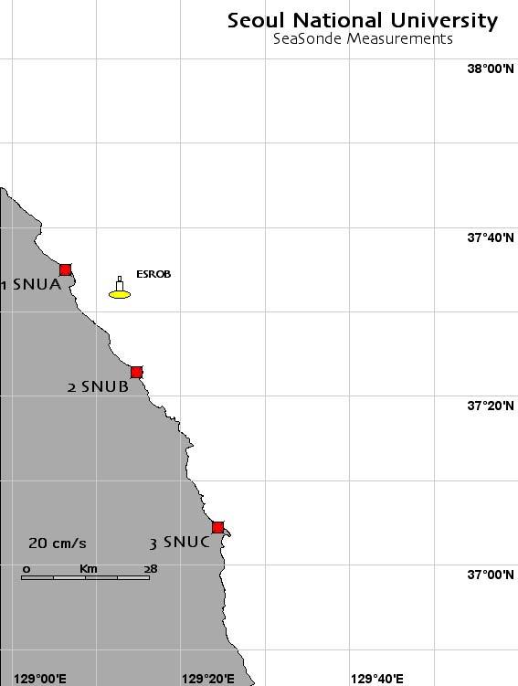
1 Accuracy of surface current velocity measurements obtained from HF radar along the east coast of Korea Hanna Na, Kuh Kim and Kyung-Il Chang School of Earth and Environmental Sciences/ Research Institute of Oceanography Seoul National University, Seoul, Korea

2 Introduction - HF radar measurement Radar measures the range, bearing, and speed of a target. Where radial currents from Site 1 and 2 overlap (e.g., ), the resultant vector provides both speed and direction of the currents

 and")
3 Introduction East/Japan Sea Inflow through the Korea/Tsushima Strait East Korea Warm Current (EKWC) and its separation position
4 Introduction Accuracy of HF radar measurement Accuracy Typical RMS error: 7 cm/s Reference RMS error (cm/s) location Emery et al., ~19 Along the California coast Yoshikawa et al., ~11.3 Korea/Tsushima Strait Chapman and Graber, 1997 ~ 15 Along the North Carolina Coast
5 Objectives - To compare surface current velocity from HF radar measurement with in situ measurement - To evaluate the accuracy of the HF radar measurement - To discuss the source of error
6 Contents 1 Introduction 2 HF radar measurement 3 In Situ measurement 4 Comparison of the two measurements 5 Discussion


7 HF radar measurement

8 HF radar measurement Frequency: ~ 13 MHz Range: ~ 70 Km Resolution: ~ 3 Km Temporal interval: hourly Surface current velocity vectors using site 1 and site 2 for three months from April to June, 2007

")
9 In Situ measurement ESROB East Sea Real-time Ocean monitoring Buoy Wind speed & direction Air pressure, humidity Down-looking ADCP(300kHz) SBE37(T,P,C) 6EA
10 Comparison of the two measurements HF radar measurements In Situ measurements
11 Comparison of the two measurements U-velocity(cm/s) V-velocity(cm/s) hourly mean -80 hourly mean 1-Apr 1-May 1-Jun 1-Jul Time (Day-Month) 1-Apr 1-May 1-Jun 1-Jul Time (Day-Month) U-velocity(cm/s) daily mean V-velocity(cm/s) daily mean HFradar ESROB 1-Apr 1-May 1-Jun 1-Jul 1-Apr 1-May 1-Jun 1-Jul Time (Day-Month) Time (Day-Month)
12 Comparison of the two measurements hourly mean Regression line Y=AX+B (solid line) Y=A`X (dotted line) HF radar U-velocity (cm/s) HF radar V-velocity (cm/s) ESROB U-velocity (cm/s) ESROB V-velocity (cm/s) U- velocity V-velocity Number of samples Regression coefficient, A Regression coefficient, B Regression coefficient, A Correlation coefficient RMS error (cm/s)
13 Comparison of the two measurements daily mean Regression line Y=AX+B (solid line) Y=A`X (dotted line) HF radar U-velocity (cm/s) HF radar V-velocity (cm/s) ESROB U-velocity (cm/s) ESROB V-velocity (cm/s) U- velocity V-velocity Number of samples Regression coefficient, A Regression coefficient, B Regression coefficient, A Correlation coefficient RMS error (cm/s)
14 Comparison of the two measurements Why do U-velocities show large difference, while V-velocities show small difference? σ diff = σ HF + σ in situ + σ 2 physics Chapman et al., 1997 HF radar measurements In Situ measurements Near surface currents (~ 1m) Averaged over 3 km square Typically greater than the HF radar s effective depth At essentially a single point in space


15 Discussion GDOP (Geometrical Dilution of precision) - Coefficient of uncertainty that characterizes the effect of the geometry of the coupled radar system on the measurement and position determination errors - A low GDOP corresponds to an optical geometric configuration of radar stations Trujillo et al., 2004

16 Discussion Chapman et al., 1997 α : the mean look angle θ : half of the angle of the intersecting beams, and σ : the root mean square differences in the current estimates α = o θ = σ = σ n σ = σ e o North GDOP: 0.98 East GDOP: 1.79
17 Summary Objectives - To compare surface current velocity from HF radar measurement with in situ measurement - To evaluate the accuracy of the HF radar measurement - To discuss the source of error Results - More low-frequency variability of the V-velocity High correlation coefficient for V-velocity - RMS error of hourly mean U-velocity and V-velocity were about 13 and 10 cm/s, respectively. RMS error of daily mean U-velocity and V-velocity were about 7 and 6 cm/s, respectively - High east GDOP value at the position of in situ measurement explained low correlation coefficient and large RMS error of U- velocity


18 Accuracy of surface current velocity measurements obtained from HF radar along the east coast of Korea Thank you.
19 References R.D. Chapman, L.K. Shay, H.C. Graber, J.B. Edson, A. Karachintsev, C.L. Trump and D.B. Ross (1997), "On the accuracy of HF radar surface current measurements: intercomparisons with ship-based sensors," J. Geophys. Res., 102, pp. 18,737-18,748. D.A. Trujillo, F.J. Kelly, J.C. Perez, H.R. Riddles, J.S. Bonner, Accuracy of Surface Current Velocity Measurements Obtained from HF Radar in Corpus Christi Bay, Texas, IEEE, Yoshikawa, Y., A. Masuda, K. Marubayashi, M. Ishibashi, and A. Okuno (2006), On the accuracy of HF radar measurement in the Tsushima Strait, J. Geophys. Res., 111, C04009, doi: /2005jc Emery, B., L. WashBurn, J. Harlan, Evaluating Radial Current Measurements from CODAR High-Frequency Radars with Moored Current Meters, JAOT, 2004

20 How to increase the accuracy Antenna Pattern Measurement (APM) Antenna patterns are often distorted when an antenna is deployed in the field. Tests indicate that the local environment, not system hardware, causes the most significant distortion of the pattern from the theoretical shape.
21 Sources of U-velocity difference Spatial characteristics of U-velocity 2 σ physics if U-velocity has large spatial variability near the in situ measurement location if U-velocity has large vertical shear near the in situ measurement location
Geometric Dilution of Precision of HF Radar Data in 2+ Station Networks. Heather Rae Riddles May 2, 2003
 Geometric Dilution of Precision of HF Radar Data in + Station Networks Heather Rae Riddles May, 003 Introduction The goal of this Directed Independent Study (DIS) is to provide a basic understanding of
Drift Ice Detection by HF radar off Mombetsu
 Drift Ice Detection by HF radar off Mombetsu 凘 氷解而流也 Wei Zhang 1, Naoto Ebuchi 1, Brian Emery 2 and Hiroto Abe 1 1 Institute of Low Temperature Science, Hokkaido University 1 2 Marine Science Institute,
Test results of Array Type HF Radar in the eastern coast of Korea
 Test results of Array Type HF Radar in the eastern coast of Korea Seung Bea Choi 1, Hyeon Seong Kim 1, Jong Yoon Moon 1, Kang Ho Lee 1, Isamu Ogasawara 2 and Matthias Kniephoff 3 1 Marine Information Technology,
OC3570 PROJECT REPORT: A COMPARISON OF COASTAL CURRENTS USING LAND BASED HF RADAR AND SHIP BOARD ADCP OBSERVATIONS. LCDR Steve Wall, RAN Winter 2007
 OC3570 PROJECT REPORT: A COMPARISON OF COASTAL CURRENTS USING LAND BASED HF RADAR AND SHIP BOARD ADCP OBSERVATIONS LCDR Steve Wall, RAN Winter 2007 Background High Frequency (HF) radar between 3 and 30MHz
HF Radar Measurements of Ocean Surface Currents and Winds
 HF Radar Measurements of Ocean Surface Currents and Winds John F. Vesecky Electrical Engineering Department, University of California at Santa Cruz 221 Baskin Engineering, 1156 High Street, Santa Cruz
Quantifying and Reducing the DOA Estimation Error Resulting from Antenna Pattern Deviation for Direction-Finding HF Radar
 remote sensing Article Quantifying and Reducing the DOA Estimation Error Resulting from Antenna Pattern Deviation for Direction-Finding HF Radar Yeping Lai, Hao Zhou * ID, Yuming Zeng and Biyang Wen The
CODAR. Ben Kravitz September 29, 2009
 CODAR Ben Kravitz September 29, 2009 Outline What is CODAR? Doppler shift Bragg scatter How CODAR works What CODAR can tell us What is CODAR? Coastal Ocean Dynamics Application Radar Land-based HF radar
SeaSonde Measurements in COPE-3
 SeaSonde Measurements in COPE-3 Jeffrey D. Paduan Department of Oceanography, Code OC/Pd Naval Postgraduate School Monterey, CA 93943 phone: (831) 656-3350; fax: (831) 656-2712; email: paduan@nps.navy.mil
HF-Radar Network Near-Real Time Ocean Surface Current Mapping
 HF-Radar Network Near-Real Time Ocean Surface Current Mapping The HF-Radar Network (HFRNet) acquires surface ocean radial velocities measured by HF-Radar through a distributed network and processes the
Dual Use Multi-Frequency Radar For Current Shear Mapping and Ship Target Classification
 Dual Use Multi-Frequency Radar For Current Shear Mapping and Ship Target Classification Dennis B. Trizna, Ph. D. Imaging Science Research, Inc. 9310A Old Keene Mill Road Burke, VA 22015 V 703 801-1417,
The HF oceanographic radar development in China. Wu Xiongbin School of Electronic Information Wuhan University
 The HF oceanographic radar development in China Wu Xiongbin School of Electronic Information Wuhan University xbwu@whu.edu.cn Outlines An overall introduction Development of the OSMAR HFSWR technique OSMAR
The World s First Triple Nested HF Radar Test Bed for Current Mapping and Ship Detection
 The World s First Triple Nested HF Radar Test Bed for Current Mapping and Ship Detection Hugh Roarty Scott Glenn Josh Kohut Rutgers University Don Barrick Pam Kung CODAR Ocean Sensors FUTURE WORK (ROW4)
Technical Report. Very-High Frequency Surface Current Measurement Along the Inshore Boundary of the Florida Current During NRL 2001
 RSMAS 24-3 Technical Report: Very-High Frequency Surface Current Measurement Along the Inshore Boundary of the Florida Current During NRL 21 by Jorge J. Martinez-Pedraja 1, Lynn K. Shay 1, Thomas M. Cook
Improving HF Radar Estimates of Surface Currents Using Signal Quality Metrics, with Application to the MVCO High-Resolution Radar System
 SEPTEMBER 2012 K I R I N C I C H E T A L. 1377 Improving HF Radar Estimates of Surface Currents Using Signal Quality Metrics, with Application to the MVCO High-Resolution Radar System ANTHONY R. KIRINCICH
Improving HF Radar Surface Current Measurements with Measured Antenna Beam Patterns
 SEPTEMER 2003 K O H U T N D G L E N N 1303 Improving HF Radar Surface Current Measurements with Measured ntenna eam Patterns JOSH T. KOHUT ND SCOTT M. GLENN Institute of Marine and Coastal Sciences, Rutgers
Directional Wave Information from the SeaSonde PREPRINT
 Directional Wave Information from the SeaSonde PREPRINT Belinda Lipa Codar Ocean Sensors 25 La Sandra Way, Portola Valley 94028 Bruce Nyden Codar Ocean Sensors 00 Fremont Ave Suite 45, Los Altos, CA 94024
Directional Wave Information from the SeaSonde
 Directional Wave Information from the SeaSonde PREPRINT ACCEPTED FOR PUBLICATION IN IEEE JOE Belinda Lipa 1 Codar Ocean Sensors 125 La Sandra Way, Portola Valley 9428 Bruce Nyden Codar Ocean Sensors 1
HF Radar Processing Using Nearest-Neighbor Statistics. A Technical Report developed for the California Coastal Conservancy for the
 HF Radar Processing Using Nearest-Neighbor Statistics A Technical Report developed for the California Coastal Conservancy for the Coastal Ocean Currents Monitoring Program August 2008 by: Chris Halle Bodega
HIGH-FREQUENCY ACOUSTIC PROPAGATION IN THE PRESENCE OF OCEANOGRAPHIC VARIABILITY
 HIGH-FREQUENCY ACOUSTIC PROPAGATION IN THE PRESENCE OF OCEANOGRAPHIC VARIABILITY M. BADIEY, K. WONG, AND L. LENAIN College of Marine Studies, University of Delaware Newark DE 19716, USA E-mail: Badiey@udel.edu
Wave Sensing Radar and Wave Reconstruction
 Applied Physical Sciences Corp. 475 Bridge Street, Suite 100, Groton, CT 06340 (860) 448-3253 www.aphysci.com Wave Sensing Radar and Wave Reconstruction Gordon Farquharson, John Mower, and Bill Plant (APL-UW)
Estimation and Assessment of Errors Related to Antenna Pattern Distortion in CODAR SeaSonde High-Frequency Radar Ocean Current Measurements
 JUNE 2010 L A W S E T A L. 1029 Estimation and Assessment of Errors Related to Antenna Pattern Distortion in CODAR SeaSonde High-Frequency Radar Ocean Current Measurements KENNETH LAWS University of California,
A Bistatic HF Radar for Current Mapping and Robust Ship Tracking
 A Bistatic HF Radar for Current Mapping and Robust Ship Tracking Dennis Trizna Imaging Science Research, Inc. V. 703-801-1417 dennis @ isr-sensing.com www.isr-sensing.com Objective: Develop methods for
Estimation of Ocean Current Velocity near Incheon using Radarsat-1 SAR and HF-radar Data
 Korean Journal of Remote Sensing, Vol.23, No.5, 2007, pp.421~430 Estimation of Ocean Current Velocity near Incheon using Radarsat-1 SAR and HF-radar Data Moon-Kyung Kang and Hoonyol Lee Department of Geophysics,
Assessment of HF Radar for Significant Wave Height Determination. Desmond Power VP, Remote Sensing, C-CORE
 Assessment of HF Radar for Significant Wave Height Determination Desmond Power VP, Remote Sensing, C-CORE Study Rationale Agenda Technology Overview Technology Assessment for CNLOPB Proposed Go Forward
APPLICATION OF OCEAN RADAR ON THE BALTIC, FEATURES AND LIMITATIONS
 APPLICATION OF OCEAN RADAR ON THE BALTIC, FEATURES AND LIMITATIONS Thomas Helzel, Matthias Kniephoff, Leif Petersen, Markus Valentin Helzel Messtechnik GmbH e-mail: helzel@helzel.com Presentation at Hydro
Manual for Real-Time Quality Control of High Frequency Radar Surface Current Data
 Manual for Real-Time Quality Control of High Frequency Radar Surface Current Data A Guide to Quality Control and Quality Assurance for High Frequency Radar Surface Current Observations Version 1.0 May
Over the Corpus Christi Bay Area HECTOR AGUILAR JR, Department of Physics
 Fitting Normal Modes to HF Radial and Total Surface Current Vector Data Over the Corpus Christi Bay Area HECTOR AGUILAR JR, Department of Physics Charles H. Ambler, Ph.D. Dean of the Graduate School APPROVED:
CYGNSS Mission Update
 International Ocean Vector Wind Science Team Meeting Portland, OR 19-21 May 2015 CYGNSS Mission Update Chris Ruf (1) CYGNSS Principal Investigator Paul Chang (2), Maria Paola Clarizia (1), Scott Gleason
and direction: Expected differences and implications
 JOURNAL OF GEOPHYSICAL RESEARCH, VOL. 102, NO. C8, PAGES 18,749-18,766, AUGUST 15, 1997 HF radar comparisons with moored estimates of current speed and direction: Expected differences and implications
HF RADAR DETECTS AN APPROACHING TSUNAMI WAVE ALREADY IN DEEP WATERS
 HF RADAR HF RADAR DETECTS AN APPROACHING TSUNAMI WAVE ALREADY IN DEEP WATERS Long-Lih Huang 1, Anna Dzvonkovskaya 2, Mal Heron 3 1 All-Star-Technology Co., Taipei, Taiwan 2 Helzel Messtechnik GmbH, Kaltenkirchen,
C three decadesz'other reviews serve that purpose (e.g., Barrick, 1978;
 STATUS OF HF RADARS FOR WAVE-HEIGHT DIRECTIONAL SPECTRAL MEASUREMENTS - Donald E. Barrick 1 Introduction SThis manuscript is a concise review of the status of high-frequency (HF) radars for measuring various
Over the Horizon Sky-wave Radar: Coordinate Registration by Sea-land Transitions Identification
 Progress In Electromagnetics Research Symposium Proceedings, Moscow, Russia, August 18 21, 2009 21 Over the Horizon Sky-wave Radar: Coordinate Registration by Sea-land Transitions Identification F. Cuccoli
David Franc. Department of Commerce Office of Radio Frequency Management
 David Franc Department of Commerce Office of Radio Frequency Management Oceanographic Radar Outline What It Does Some Examples What It Looks Like How It Works How Much It Costs Spectrum Considerations
3. Sound source location by difference of phase, on a hydrophone array with small dimensions. Abstract
 3. Sound source location by difference of phase, on a hydrophone array with small dimensions. Abstract A method for localizing calling animals was tested at the Research and Education Center "Dolphins
SMOS mission: a new way for monitoring Sea Surface Salinity?
 SMOS mission: a new way for monitoring Sea Surface Salinity? J. Boutin (1) (1) Laboratoire d Oceanographie et du Climat- Expérimentation et Applications Numériques (LOCEAN), PARIS, FRANCE Thanks to T.
ASEASONDE is a high-frequency (HF) radar system with a
 radar system with a") 850 IEEE JOURNAL OF OCEANIC ENGINEERING, VOL. 31, NO. 4, OCTOBER 2006 SeaSonde Radial Velocities: Derivation and Internal Consistency Belinda Lipa, Bruce Nyden, David S. Ullman, and Eric Terrill Abstract
850 IEEE JOURNAL OF OCEANIC ENGINEERING, VOL. 31, NO. 4, OCTOBER 2006 SeaSonde Radial Velocities: Derivation and Internal Consistency Belinda Lipa, Bruce Nyden, David S. Ullman, and Eric Terrill Abstract
SEA SURFACE TEMPERATURE RETRIEVAL USING TRMM MICROWAVE IMAGER DATA IN SOUTH CHINA SEA
 SEA SURFACE TEMPERATURE RETRIEVAL USING TRMM MICROWAVE IMAGER DATA IN SOUTH CHINA SEA Mohd Ibrahim Seeni Mohd and Mohd Nadzri Md. Reba Faculty of Geoinformation Science and Engineering Universiti Teknologi
Modeling of Ionospheric Refraction of UHF Radar Signals at High Latitudes
 Modeling of Ionospheric Refraction of UHF Radar Signals at High Latitudes Brenton Watkins Geophysical Institute University of Alaska Fairbanks USA watkins@gi.alaska.edu Sergei Maurits and Anton Kulchitsky
Applying Numerical Weather Prediction Data to Enhance Propagation Prediction Capabilities to Improve Radar Performance Prediction
 ABSTRACT Edward H. Burgess Katherine L. Horgan Department of Navy NSWCDD 18444 Frontage Road, Suite 327 Dahlgren, VA 22448-5108 USA edward.h.burgess@navy.mil katherine.horgan@navy.mil Tactical decision
Microwave Remote Sensing (1)
") Microwave Remote Sensing (1) Microwave sensing encompasses both active and passive forms of remote sensing. The microwave portion of the spectrum covers the range from approximately 1cm to 1m in wavelength.
Microwave Remote Sensing (1) Microwave sensing encompasses both active and passive forms of remote sensing. The microwave portion of the spectrum covers the range from approximately 1cm to 1m in wavelength.
High Frequency Radar Observing Systems in SEACOOS: Lessons Learned A U T H O R S
 P A P E R High Frequency Radar Observing Systems in SEACOOS: 2002-2007 Lessons Learned A U T H O R S Lynn K. Shay Rosenstiel School of Marine and Atmospheric Science, University of Miami Harvey E. Seim
Ship echo discrimination in HF radar sea-clutter
 Ship echo discrimination in HF radar sea-clutter A. Bourdillon (), P. Dorey () and G. Auffray () () Université de Rennes, IETR/UMR CNRS 664, Rennes Cedex, France () ONERA, DEMR/RHF, Palaiseau, France.
GNSS Ocean Reflected Signals
 GNSS Ocean Reflected Signals Per Høeg DTU Space Technical University of Denmark Content Experimental setup Instrument Measurements and observations Spectral characteristics, analysis and retrieval method
6/20/2012 ACORN ACORN ACORN ACORN ACORN ACORN. Arnstein Prytz. Australian Coastal Ocean Radar Network (ACORN)
") The Australian Coastal Ocean Radar Network WERA Processing and Quality Control Arnstein Prytz Australian Coastal Ocean Radar Network Marine Geophysical Laboratory School of Earth and Environmental Sciences
The Australian Coastal Ocean Radar Network WERA Processing and Quality Control Arnstein Prytz Australian Coastal Ocean Radar Network Marine Geophysical Laboratory School of Earth and Environmental Sciences
GPS Cellular Drifter Technology for Coastal Ocean Observing Systems
 SEPTEMBER 2005 O H L MANN ET AL. 1381 GPS Cellular Drifter Technology for Coastal Ocean Observing Systems J. CARTER OHLMANN Institute for Computational Earth System Science, University of California, Santa
Design and Implementation of Short Range Underwater Acoustic Communication Channel using UNET
 Design and Implementation of Short Range Underwater Acoustic Communication Channel using UNET Pramod Bharadwaj N Harish Muralidhara Dr. Sujatha B.R. Software Engineer Design Engineer Associate Professor
FLORIDA S HF RADAR NEEDS AS PART OF A COORDINTED COASTAL OBSERVING SYSTEM
 FLORIDA S HF RADAR NEEDS AS PART OF A COORDINTED COASTAL OBSERVING SYSTEM Clifford R. Merz1, Robert H. Weisberg1, Yonggang Liu1, Lynn K. (Nick) Shay2 1University of South Florida,College of Marine Science
NEAR-REAL-TIME information on the spatial variability
 484 IEEE JOURNAL OF OCEANIC ENGINEERING, VOL. 43, NO. 2, APRIL 2018 Assessment of Surface Currents Measured With High-Frequency Phased-Array Radars in Two Regions of Complex Circulation Lucy R. Wyatt,
High Resolution Ocean Radar Observations in Ports and Harbours
 High Resolution Ocean Radar Observations in Ports and Harbours M.L. Heron 1,2, A. Prytz 2 and C. Steinberg 1,3 1 AIMS@JCU; 2 School of Environmental and Earth Sciences, James Cook University, Townsville,
File Formats Used for CODAR Radial Data
 File Formats Used for CODAR Radial Data Mark Otero April 8, 2005 Scripps Institution of Oceanography 8861 Shellback Way Keck Center, #233 La Jolla, CA 92093-0213 Phone (858) 822 3537 Fax (858) 822 1903
Local GPS tropospheric tomography
 LETTER Earth Planets Space, 52, 935 939, 2000 Local GPS tropospheric tomography Kazuro Hirahara Graduate School of Sciences, Nagoya University, Nagoya 464-8602, Japan (Received December 31, 1999; Revised
Passive Emitter Geolocation using Agent-based Data Fusion of AOA, TDOA and FDOA Measurements
 Passive Emitter Geolocation using Agent-based Data Fusion of AOA, TDOA and FDOA Measurements Alex Mikhalev and Richard Ormondroyd Department of Aerospace Power and Sensors Cranfield University The Defence
We calculate the median of individual (observed) seismic spectra over 3-hour time slots.
 seismic spectra over 3-hour time slots.") Methods Seismic data preparation We calculate the median of individual (observed) seismic spectra over 3-hour time slots. Earthquake and instrument glitches are easily identified as short pulses and are
Methods Seismic data preparation We calculate the median of individual (observed) seismic spectra over 3-hour time slots. Earthquake and instrument glitches are easily identified as short pulses and are
Intercomparison of a WaveGuide radar and two Directional Waveriders
 Introduction T. van der Vlugt Radac Zomerluststraat LM Haarlem The Netherlands email: tom@radac.nl Down-looking FMCW radars for wave measurements are in use already for years. They have Intercomparison
OBSERVATION PERFORMANCE OF A PARIS ALTIMETER IN-ORBIT DEMONSTRATOR
 OBSERVATION PERFORMANCE OF A PARIS ALTIMETER IN-ORBIT DEMONSTRATOR Salvatore D Addio, Manuel Martin-Neira Acknowledgment to: Nicolas Floury, Roberto Pietro Cerdeira TEC-ETP, ETP, Electrical Engineering
Abstract A dual-station High Frequency Wellen Radar (WERA), transmitting at MHz, was deployed along the west Florida Shelf during the summer of
, transmitting at MHz, was deployed along the west Florida Shelf during the summer of") High Frequency Radar Mapping of Surface Currents Using WERA Lynn K. Shay 1, Jorge Martinez-Pedraja 1, Thomas M. Cook 1, Brian K. Haus 1, Robert H. Weisberg 2 1 Rosenstiel School of Marine and Atmospheric
High Frequency Radar Mapping of Surface Currents Using WERA Lynn K. Shay 1, Jorge Martinez-Pedraja 1, Thomas M. Cook 1, Brian K. Haus 1, Robert H. Weisberg 2 1 Rosenstiel School of Marine and Atmospheric
Ocean SAR altimetry. from SIRAL2 on CryoSat2 to Poseidon-4 on Jason-CS
 Ocean SAR altimetry from SIRAL2 on CryoSat2 to Poseidon-4 on Jason-CS Template reference : 100181670S-EN L. Phalippou, F. Demeestere SAR Altimetry EGM NOC, Southampton, 26 June 2013 History of SAR altimetry
This document is downloaded from DR-NTU, Nanyang Technological University Library, Singapore.
 This document is downloaded from DR-NTU, Nanyang Technological University Library, Singapore. Title Radar measured rain attenuation with proposed Z-R relationship at a tropical location Author(s) Yeo,
THE ELECTROMAGNETIC FIELD THEORY. Dr. A. Bhattacharya
 1 THE ELECTROMAGNETIC FIELD THEORY Dr. A. Bhattacharya The Underlying EM Fields The development of radar as an imaging modality has been based on power and power density It is important to understand some
A STUDY OF DOPPLER BEAM SWINGING USING AN IMAGING RADAR
 .9O A STUDY OF DOPPLER BEAM SWINGING USING AN IMAGING RADAR B. L. Cheong,, T.-Y. Yu, R. D. Palmer, G.-F. Yang, M. W. Hoffman, S. J. Frasier and F. J. López-Dekker School of Meteorology, University of Oklahoma,
Observations of the deep-water mid-frequency ambient noise spatial structure and temporal fluctuation characteristics.
 Mid-Frequency Ambient Noise Experiment 4-21 August 2018 Objective Observations of the deep-water mid-frequency ambient noise spatial structure and temporal fluctuation characteristics. Background The 2D
Dual-Beam Interferometry for Ocean Surface Current Vector Mapping
 IEEE TRANSACTIONS ON GEOSCIENCE AND REMOTE SENSING, VOL. 39, NO. 2, FEBRUARY 2001 401 Dual-Beam Interferometry for Ocean Surface Current Vector Mapping Stephen J. Frasier, Member, IEEE, and Adriano J.
IBIS range. GeoRadar Division. GeoRadar Division. Static and Dynamic Monitoring of Civil Engineering Structures by Microwave Interferometry
 Static and Dynamic Monitoring of Civil Engineering Structures by Microwave Interferometry Garry Spencer and Mark Bell 1 PRODUCTS IBIS range APPLICATIONS IBIS - FL LANDSLIDE & DAM MONITORING IBIS - FM SLOPE
Some Notes on Beamforming.
 The Medicina IRA-SKA Engineering Group Some Notes on Beamforming. S. Montebugnoli, G. Bianchi, A. Cattani, F. Ghelfi, A. Maccaferri, F. Perini. IRA N. 353/04 1) Introduction: consideration on beamforming
Wide Swath Simultaneous Measurements of Winds and Ocean Surface Currents
 Wide Swath Simultaneous Measurements of Winds and Ocean Surface Currents Ernesto Rodriguez Jet Propulsion Laboratory California Institute of Technology 1 Thanks! The JPL DFS/ERM team for design of the
Final Examination. 22 April 2013, 9:30 12:00. Examiner: Prof. Sean V. Hum. All non-programmable electronic calculators are allowed.
 UNIVERSITY OF TORONTO FACULTY OF APPLIED SCIENCE AND ENGINEERING The Edward S. Rogers Sr. Department of Electrical and Computer Engineering ECE 422H1S RADIO AND MICROWAVE WIRELESS SYSTEMS Final Examination
RECOMMENDATION ITU-R S *
 Rec. ITU-R S.1339-1 1 RECOMMENDATION ITU-R S.1339-1* Rec. ITU-R S.1339-1 SHARING BETWEEN SPACEBORNE PASSIVE SENSORS OF THE EARTH EXPLORATION-SATELLITE SERVICE AND INTER-SATELLITE LINKS OF GEOSTATIONARY-SATELLITE
EVLA System Commissioning Results
 EVLA System Commissioning Results EVLA Advisory Committee Meeting, March 19-20, 2009 Rick Perley EVLA Project Scientist t 1 Project Requirements EVLA Project Book, Chapter 2, contains the EVLA Project
A Bistatic HF Radar for Current Mapping and Robust Ship Tracking
 A Bistatic HF Radar for Current Mapping and Robust Ship Tracking D. B. Trizna Imaging Science Research, Inc. 6103B Virgo Court Burke, VA, 22015 USA Abstract- A bistatic HF radar has been developed for
Design of an Airborne SLAR Antenna at X-Band
 Design of an Airborne SLAR Antenna at X-Band Markus Limbach German Aerospace Center (DLR) Microwaves and Radar Institute Oberpfaffenhofen WFMN 2007, Markus Limbach, Folie 1 Overview Applications of SLAR
HIGH FREQUENCY INTENSITY FLUCTUATIONS
 Proceedings of the Seventh European Conference on Underwater Acoustics, ECUA 004 Delft, The Netherlands 5-8 July, 004 HIGH FREQUENCY INTENSITY FLUCTUATIONS S.D. Lutz, D.L. Bradley, and R.L. Culver Steven
Prediction of LOS based Path-Loss in Urban Wireless Sensor Network Environments
 Prediction of LOS based Path-Loss in Urban Wireless Sensor Network Environments Myungnam Bae, Inhwan Lee, Hyochan Bang ETRI, IoT Convergence Research Department, 218 Gajeongno, Yuseong-gu, Daejeon, 305-700,
On Discriminating CubeSats Launched Together
 On Discriminating CubeSats Launched Together Michael Cousins SRI International 2008 CubeSat Developer s Workshop San Luis Obispo, California 1 CubeSat Discrimination Scope: Discuss and explore the problem
MONITORING SEA LEVEL USING GPS
 38 MONITORING SEA LEVEL USING GPS Hasanuddin Z. Abidin* Abstract GPS (Global Positioning System) is a passive, all-weather satellite-based navigation and positioning system, which is designed to provide
New Approach for Tsunami Detection Based on RTK-GNSS Using Network of Ships
 New Approach for Tsunami Detection Based on RTK-GNSS Using Network of Ships Tokyo University of Marine Science and Technology Ryuta Nakaosone Nobuaki Kubo Background After the Indian Ocean Tsunami on 2004,
Post beam steering techniques as a means to extract horizontal winds from atmospheric radars
 Post beam steering techniques as a means to extract horizontal winds from atmospheric radars VN Sureshbabu 1, VK Anandan 1, oshitaka suda 2 1 ISRAC, Indian Space Research Organisation, Bangalore -58, India
Effects of variability separation for the northern Japan/East Sea obtained from satellite data
 Effects of variability separation for the northern Japan/East Sea obtained from satellite data 46 44 42 40 38 36 130 135 140 58.5 53 47.5 42 36.5 31 25.5 20 14.5 9 3.5 Dmitry D. Kaplunenko, Olga O. Trusenkova,
A Matlab-Based Virtual Propagation Tool: Surface Wave Mixed-path Calculator
 430 Progress In Electromagnetics Research Symposium 2006, Cambridge, USA, March 26-29 A Matlab-Based Virtual Propagation Tool: Surface Wave Mixed-path Calculator L. Sevgi and Ç. Uluışık Doğuş University,
Global Positioning System: what it is and how we use it for measuring the earth s movement. May 5, 2009
 Global Positioning System: what it is and how we use it for measuring the earth s movement. May 5, 2009 References Lectures from K. Larson s Introduction to GNSS http://www.colorado.edu/engineering/asen/
Sea Surface Echoes Observed with the MU Radar under Intense Sporadic E Conditions. Tadahiko OGAwA1, Mamoru YAMAMOTO2, and Shoichiro FUKA02
 Letter J. Geomaq. Geoelectr., 48, 447-451, 1996 Sea Surface Echoes Observed with the MU Radar under Intense Sporadic E Conditions Tadahiko OGAwA1, Mamoru YAMAMOTO2, and Shoichiro FUKA02 1Solar-Terrestrial
Table 9-1 Operating characteristics of upper-air meteorological monitoring systems. BOUNDARY LAYER VARIABLES RADIOSONDE DOPPLER SODAR
 Table 9-1 VARIABLES p, T, RH Vector winds (WS, WD) Vector winds (WS, WD) Virtual temperature (T v ) Measured Vector winds (WS, WD) u,v,w wind components u,v,w wind components w wind component Altitude
Models of Acoustic Wave Scattering at khz from Turbulence in Shallow Water
 Models of Acoustic Wave Scattering at.-1 khz from Turbulence in Shallow Water Tokuo Yamamoto Division of Applied Marine Physics, RSMAS, University of Miami, 6 Rickenbacker Causeway Miami, FL 3319 phone:
The technical contribution of QZSS and GNSS to Tsunami early warning system
 0/17 Tsunami Workshop by Sentinel Asia @Sendai International Center Meeting Room 5 The technical contribution of QZSS and GNSS to Tsunami early warning system July 3, 2012 K. Mutoh, J. Yamashita, and S.
Transponder Based Ranging
 Transponder Based Ranging Transponderbasierte Abstandsmessung Gerrit Kalverkamp, Bernhard Schaffer Technische Universität München Outline Secondary radar principle Looking around corners: Diffraction of
Technical capabilities of military calibration laboratories
 Technical capabilities of military calibration laboratories Measurement domain Measuring range Measurement Remarks 3 ACCELERATION, VELOCITY AND DISTANCE Acceleration of Vibration - sensitivity (0,1 1000
Cross-correlation Characteristics of Multi-link Channel based on Channel Measurements at 3.7GHz
 Cross-correlation Characteristics of Multi-link Channel based on Channel Measurements at 3.7GHz Myung-Don Kim*, Jae Joon Park*, Hyun Kyu Chung* and Xuefeng Yin** *Wireless Telecommunications Research Department,
Remote Sensing. Ch. 3 Microwaves (Part 1 of 2)
") Remote Sensing Ch. 3 Microwaves (Part 1 of 2) 3.1 Introduction 3.2 Radar Basics 3.3 Viewing Geometry and Spatial Resolution 3.4 Radar Image Distortions 3.1 Introduction Microwave (1cm to 1m in wavelength)
Remote Sensing Ch. 3 Microwaves (Part 1 of 2) 3.1 Introduction 3.2 Radar Basics 3.3 Viewing Geometry and Spatial Resolution 3.4 Radar Image Distortions 3.1 Introduction Microwave (1cm to 1m in wavelength)
Rec. ITU-R P RECOMMENDATION ITU-R P PROPAGATION BY DIFFRACTION. (Question ITU-R 202/3)
") Rec. ITU-R P.- 1 RECOMMENDATION ITU-R P.- PROPAGATION BY DIFFRACTION (Question ITU-R 0/) Rec. ITU-R P.- (1-1-1-1-1-1-1) The ITU Radiocommunication Assembly, considering a) that there is a need to provide
Rec. ITU-R P.- 1 RECOMMENDATION ITU-R P.- PROPAGATION BY DIFFRACTION (Question ITU-R 0/) Rec. ITU-R P.- (1-1-1-1-1-1-1) The ITU Radiocommunication Assembly, considering a) that there is a need to provide
Groundwave Propagation, Part One
 Groundwave Propagation, Part One 1 Planar Earth groundwave 2 Planar Earth groundwave example 3 Planar Earth elevated antenna effects Levis, Johnson, Teixeira (ESL/OSU) Radiowave Propagation August 17,
Theoretical Simulations of GNSS Reflections from Bare and Vegetated Soils
 Theoretical Simulations of GNSS Reflections from Bare and Vegetated Soils R. Giusto 1, L. Guerriero, S. Paloscia 3, N. Pierdicca 1, A. Egido 4, N. Floury 5 1 DIET - Sapienza Univ. of Rome, Rome DISP -
Performance Of Troposcatter Communications with Different Diversity Technique on Fading Correlation Analysis
 Performance Of Troposcatter Communications with Different Diversity Technique on Fading Correlation Analysis 1 P.Varunkumar JNTUA College of Engineering, Pulivendula, Andhra Pradesh 2 K.Aparna JNTUA College
Material Parameter Measurement (MPM)
") Material Parameter Measurement (MPM) C4 Software Module and Accessory of the KLIPPEL ANALYZER SYSTEM (Document Revision 1.3) FEATURES Measure E modulus and damping Evaluate raw materials Specify loudspeaker
Material Parameter Measurement (MPM) C4 Software Module and Accessory of the KLIPPEL ANALYZER SYSTEM (Document Revision 1.3) FEATURES Measure E modulus and damping Evaluate raw materials Specify loudspeaker
Progress in Refreshing the Tropical Atmosphere Ocean (TAO) Array
 Array") Progress in Refreshing the Tropical Atmosphere Ocean (TAO) Array Richard L. Crout, PhD, Dawn Petraitis, Lex LeBlanc, Landry J. Bernard, and Karen Grissom NOAA/NWS National Data Buoy Center Stennis Space
Progress in Refreshing the Tropical Atmosphere Ocean (TAO) Array Richard L. Crout, PhD, Dawn Petraitis, Lex LeBlanc, Landry J. Bernard, and Karen Grissom NOAA/NWS National Data Buoy Center Stennis Space
Wave and tidal power measurement using HF radar
 WINTERNATIONAL YATT : W AVE ANDMARINE TIDAL POWER ENERGY MEASUREMENT JOURNAL, VOL. USING 1, NO. HF 2, RADAR NOVEMBER 2018 123 Wave and tidal power measurement using HF radar Lucy R Wyatt School of Mathematics
The Global Positioning System
 The Global Positioning System 5-1 US GPS Facts of Note DoD navigation system First launch on 22 Feb 1978, fully operational in 1994 ~$15 billion (?) invested to date 24 (+/-) Earth-orbiting satellites
Performance Gain of Smart Antennas with Hybrid Combining at Handsets for the 3GPP WCDMA System
 Performance Gain of Smart Antennas with Hybrid Combining at Handsets for the 3GPP WCDMA System Suk Won Kim 1, Dong Sam Ha 1, Jeong Ho Kim 2, and Jung Hwan Kim 3 1 VTVT (Virginia Tech VLSI for Telecommunications)
Regenerating high resolution data from a lower resolution weather radar
 Regenerating high resolution data from a lower resolution weather radar M.R. Rasmussen 1, S. Thorndahl 1, J. E. Nielsen 1,J. B. Larsen 1, N.E. Jensen 2 1 Aalborg University, Department of Civil Engineering,
Geodetic Reference Frame Theory
 Technical Seminar Reference Frame in Practice, Geodetic Reference Frame Theory and the practical benefits of data sharing Geoffrey Blewitt University of Nevada, Reno, USA http://geodesy.unr.edu Sponsors:
Multipath and Atmospheric Propagation Errors in Offshore Aviation DGPS Positioning
 Multipath and Atmospheric Propagation Errors in Offshore Aviation DGPS Positioning J. Paul Collins, Peter J. Stewart and Richard B. Langley 2nd Workshop on Offshore Aviation Research Centre for Cold Ocean
A New Wave Directional Spectrum Measurement Instrument
 A New Wave Directional Spectrum Measurement Instrument Andrew Kun ) Alan Fougere ) Peter McComb 2) ) Falmouth Scientific Inc, Cataumet, MA 234 2) Centre of Excellence in Coastal Oceanography and Marine