ICAO Global Provisions and Regional Developments related to GNSS
|
|
|
- Ashlee Evans
- 5 years ago
- Views:
Transcription

1 ICAO Global Provisions and Regional Developments related to GNSS Mohamed Smaoui ICAO Deputy Regional Director, Middle East Office, Cairo, Egypt Rabat, Morocco, 7 8 November 2017
2 OUTLINE Introduction GNSS developments in ICAO ICAO policy on GNSS GNSS performance requirements GNSS elements Future GNSS evolution MID Region Strategy Conclusion 21 November
3 Introduction - ICAO Convention (Chicago, 1944) and Annexes UN Specialized Agency 191 member States Assembly (every 3 years) Council (36 States) Air Navigation Commission (19 members) Air Navigation Bureau Standards, Recommended Practices (SARPs) Headquarters: Montreal 7 Regional Offices: Bangkok, Cairo, Dakar, Lima, Mexico, Nairobi, Paris
4 Introduction - GNSS The ICAO definition: GNSS. A worldwide position and time determination system that includes one or more satellite constellations, aircraft receivers and system integrity monitoring, augmented as necessary to support the required navigation performance for the intended operation. [ICAO Annex 10, Volume I] The practical foundation: 1994/1996: US and Russia offer to ICAO to provide GPS (Global Positioning System)/GLONASS (GLObal NAvigation Satellite System) service for the foreseeable future on a continuous worldwide basis and free of direct user fees


5 Global Provisions Annex 10, Volume I GNSS Manual 21 November
6 GNSS developments in ICAO 1991: 10 th Air Navigation Conference requests the initiation of an agreement between ICAO and GNSS-provider States concerning quality and duration of GNSS 1993: ICAO GNSS Panel established to develop SARPs in support of aeronautical applications of GNSS 1994/1996: GPS/GLONASS offers from US/Russia 1999: GNSSP completes the development of GNSS SARPS (applicable 2001) 2002 today: GNSSP (subsequently renamed NSP) develops GNSS SARPs updates and enhancements 2003: 11 th Air Navigation Conference recommends a worldwide transition to GNSS-based air navigation and implementation of APV-I (SBAS) 2007: 36 th Assembly calls for implementation of PBN RNAV and RNP and for implementation of APV BaroVNAV and/or APV I (SBAS) for all instrument runways by : 37 th Assembly confirms and updates the commitment 2012: 12 th Air Navigation Conference addresses issues of use of multiple constellations and GNSS vulnerabilities 2017: Global Air Navigation Industry Symposium (GANIS, December) will revisit the issues 2018: 13 th Air Navigation Conference charting the way forward
7 ICAO policy on GNSS 1994: Statement of ICAO policy on CNS/ATM systems implementation and operation approved by the ICAO Council: GNSS should be implemented as an evolutionary progression from existing global navigation satellite systems, including the United States GPS and the Russian Federation s GLONASS, towards an integrated GNSS over which Contracting States exercise a sufficient level control on aspects related to its use by civil aviation. ICAO shall continue to explore, in consultation with Contracting States, airspace users and service providers, the feasibility of achieving a civil, internationally controlled GNSS 1998: Assembly resolutions A32-19 ( Charter on the Rights and Obligations of States Relating to GNSS Services ) and A32-20 ( Development and elaboration of an appropriate long-term legal framework to govern the implementation of GNSS )
8 GNSS Manual The ICAO Charter on the Rights and Obligations of States Relating to GNSS Services highlights the principles that shall apply in the implementation and operation of GNSS, including: the primacy of safety; non-discriminatory access to GNSS services; State sovereignty; the obligation of provider States to ensure reliability of services; and cooperation and mutual assistance in global planning. The availability of multiple constellations broadcasting on multiple frequencies will make GNSS more robust and will allow service expansion with increased benefits after 2020 when systems and avionics are available. In the meantime, ANS providers can work with aircraft operators to expand GNSS-based services and benefits while planning next generation services. 21 November
. 21 November 2017 9")
9 GANP When planning to implement GNSSbased operations, States are encouraged to refer to the GANP and relevant ASBUs, to comply with ICAO provisions; and to take advantage of the expertise and information available at the ICAO planning and implementation regional groups (PIRGs). 21 November
10 Current ICAO Directives on GNSS Implementation 12 th Air Navigation Conference (2012) - Recommendations Recommendation 6/5 ICAO work programme to support global navigation satellite system evolution Recommendation 6/6 Use of multiple constellations Recommendation 6/7 Assistance to States in mitigating global navigation satellite system vulnerabilities Recommendation 6/8 Planning for mitigation of global navigation satellite system (GNSS) vulnerabilities Recommendation 6/9 Ionosphere and space weather information for future global navigation satellite system implementation. 21 November
11 Current ICAO Directives on GNSS Implementation ICAO Assembly Resolution A37/11 Implementation of performance based navigation (PBN) approaches with vertical guidance (APV)
12 GNSS signal-in-space performance requirements (ICAO Annex 10, Volume I) Accuracy The difference between the estimated and actual aircraft position Integrity A measure of the trust which can be placed in the correctness of the information supplied by the total system. It includes the ability of the system to alert the user when the system should not be used for the intended operation (alert) within a prescribed time period (time-to-alert) Continuity The capability of the system to perform its function without unscheduled interruptions during the intended operation Availability The portion of time during which the system is simultaneously delivering the required accuracy, integrity and continuity
13 GNSS signal-in-space performance requirements (ICAO Annex 10, vol.i) Typical operation Accuracy horizontal 95% (Notes 1 and 3) Accuracy vertical 95% (Notes 1 and 3) Integrity (Note 2) Time-to-alert (Note 3) Continuity (Note 4) Availability (Note 5) En-route 3.7 km (2.0 NM) N/A /h 5 min /h to /h 0.99 to En-route, Terminal 0.74 km (0.4 NM) N/A /h 15 s /h to /h 0.99 to Initial approach, Intermediate approach, Non-precision approach (NPA), Departure 220 m (720 ft) N/A /h 10 s /h to /h 0.99 to Approach operations with vertical guidance (APV-I) 16.0 m (52 ft) 20 m (66 ft) in any approach 10 s per 15 s 0.99 to Approach operations with vertical guidance (APV-II) 16.0 m (52 ft) 8.0 m (26 ft) in any approach 6 s per 15 s 0.99 to Category I precision approach (Note 7) NOTES. [ ] 16.0 m (52 ft) 6.0 m to 4.0 m (20 ft to 13 ft) (Note 6) in any approach 6 s per 15 s 0.99 to
14 GNSS elements: ICAO GNSS Standards Menu System ICAO Standard? Infrastructure in place today? Aircraft provisions today? In operational use by aviation today? GPS L1 Yes Yes Yes Yes, globally GLONASS Yes Yes Russia Russia SBAS L1 Yes Regional support (WAAS, MSAS, Yes Yes, regionally EGNOS, GAGAN, SDCM ) GBAS Cat I Yes Local support (individual airports) Yes Yes, locally GBAS Cat II/III 2018 No Advanced No development GPS L Partial (12 satellites) Early development No Galileo Partial (8 Full Operational Early development No Capability satellites +4) Beidou Partial (18 satellites) Early development No SBAS L1/L No Early development No
15 GNSS elements GPS GLONASS Augmentation Systems ABAS: Aircraft-Based Augmentation System SBAS: Space-Based Augmentation System GBAS: Ground-Based Augmentation System Purpose: to overcome inherent limitations in the service provided by the core constellations and meet GNSS signal-in-space performance requirements
16 GNSS elements: GPS ICAO GPS Standards: ICAO Annex 10, Volume I, section , applicable since 2001 Purpose of ICAO standardization of GNSS systems: 1) To enable global legal recognition of a system implemented by a single ICAO State GPS example: it was implemented by the US and turned into an international civil aviation system by ICAO standardization 2) To enable technical interoperability of systems implemented in different States (such as SBAS or GBAS): GBAS example: we want all GBAS ground stations to behave in the same way to ensure that the aircraft receiver can deal with all of them regardless of the State it is flying to (same as ILS)
17 GNSS elements: GLONASS Nominal constellation: 24 satellites (current: 23 operational + 1 in commissioning + 3 undergoing checks, as of 9 February 2016) Three orbital planes Near-circular, 19,100 km altitude (25,500 radius) 11:15-hour orbits First experimental satellite launched in 1982, operational in 1995, subsequent decline. Full operational capability subsequently restored. Operated by the Ministry of Defence of the Russian Federation Channel of standard accuracy (CSA) frequencies: 1602 MHz ± n MHz (FDMA) Uses PZ-90 reference datum instead of WGS-84 ICAO GLONASS Standards: Annex 10, Volume I, section (including conversion from PZ-90 to WGS-84)
18 GNSS elements: ABAS ABAS: aircraft-based augmentation system The foundation of ICAO GNSS Purpose: to improve positioning quality by exploiting redundancy in satellite measurements and by augmenting GNSS information with on-board aircraft information Required to ensure that performance meets Annex 10 requirements (Volume I, Table , see above) Uses redundant satellite range measurements (and/or barometric and other position information) to detect faulty signals and alert the pilot Receiver-autonomous integrity monitoring (RAIM) five satellites required (or four + baro) Fault detection and exclusion (FDE) six satellites required (or five + baro) RAIM/FDE availability: are sufficient redundant measurements available? ICAO Annex 10, Volume I, section
19 GNSS elements: SBAS SBAS: satellite-based augmentation system Augments core satellite constellations by providing ranging, integrity and correction information The information is broadcast via geostationary satellites, in the same band as the core constellations SBAS components: a network of ground reference stations that monitor satellite signals master stations processing reference stations data and generating SBAS signals uplink stations to send the messages to the geostationary satellites transponders on the satellites to broadcast SBAS messages SBAS (where supported) provides higher availability of GNSS services and lower minima than ABAS Approach procedures with vertical guidance (APV-I) CAT I-like minima ( LPV200 ) achieved with WAAS and EGNOS, developments underway for other SBAS ICAO Annex 10, Volume I, section Examples: WAAS, EGNOS, MSAS, GAGAN, SDCM
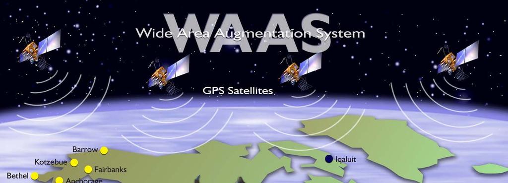
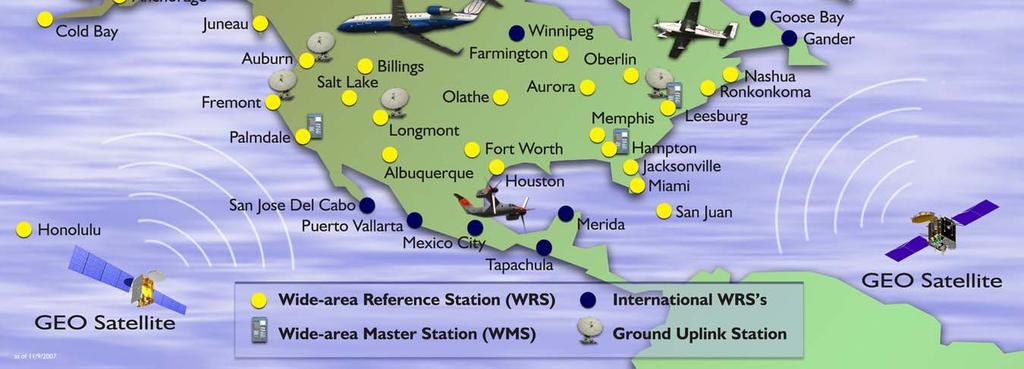
20 SBAS example: WAAS Wide Area Augmentation System (USA) Operational since reference stations 3 geostationary satellites International service agreements with Canada and Mexico Supports LPV200 approaches (CAT I - equivalent) Planned to transition to dual frequency operation (L1-L5)
21
22 SBAS example: EGNOS EGNOS: European Geostationary Navigation Overlay Service Serves Europe and Northern Africa Open Service available since 2009 Safety-of-Life Service (Declaration of Service for Aviation): March 2011 Declaration of LPV-2000 service level: September 2015 Extension of service area under consideration

23 EGNOS: locations of reference stations
24 EGNOS expansion in MID Region See EGNOS SAFETY OF LIFE SERVICE ROADMAP (January 2016) e-implementation-roadmaps
25 SBAS examples: MSAS, GAGAN, SDCM Japan: MSAS Operational since 2007, under the responsibility of the Japan Civil Aviation Bureau (JCAB) Providing aircraft with navigation service from en-route through non precision approach all over Japan (APV-I after 2023) Based on MTSAT satellite until From 2020, based on QZSS geostationary satellite India: GPS and Geo Augmented Navigation system (GAGAN) South and East Asia Certified to RNP0.1 service level (en-route and non-precision approach) in 2013 and to APV-I service level in 2015 Russia: System for Differential Correction and Monitoring (SDCM) Operational APV service expected to be approved in 2018/2019 More under development/consideration: South Korea, China, ASECNA, Australia/New Zealand
26 GNSS elements: GBAS GBAS: Ground Based Augmentation System ( LAAS: local area augmentation system in the US) Operates in the VHF NAV band (108 [112] MHz) Supports precision approach service (currently up to CAT I, with CAT II/III SARPs due for adoption in 2018) and optionally positioning service Precision approach service provides ILS-like deviation guidance for final approach segments Can support multiple runways ICAO Annex 10, Volume I, section

27 GNSS elements: GBAS
28 GBAS current implementation status Cat I operations authorized or underway: Australia: Sydney (current), Melbourne (planned) Brazil: Rio de Janeiro (2016) China: Shanghai trials Germany: Bremen, Frankfurt (5 out of 6 runways) Russia: procedures at 4 airports (installed at most major airports) Spain: Malaga US: Memphis, Newark, Houston Aircraft provisions: Several Boeing and Airbus aircraft types equipped (optional/ standard) Over 1500 air transport category aircraft equipped Cat II/III developments underway
29 GNSS evolution GPS evolution GPS Block IIF satellites: add L5 safety-of-life signal in DME band 12 satellites already transmitting pre-operational L5 signal (24 by 2024) GPS III satellite acquisition program underway (L1C civil signal in addition to existing ones, backward compatible with current L1, with performance improvements) GLONASS Achieved nominal configuration (24 satellites) The new GLONASS-K satellites and the upgraded GLONASS-M satellites support the L3 CDMA safety-of-life signal in DME band ( MHz) Galileo 8 Full Operational Capability satellites, 4 In-Orbit Verification satellites, Full 30 Satellites aimed 2020 BeiDou China s GNSS system, 18 satellites in orbit, full deployment planned by 2020,
30 GNSS evolution: Multi-Constellation/Dual frequency (MCDF) Technically promising Performance improvements (increased availability, better protection against interference and ionosphere effects) Potential operational benefits Open challenges Regulatory issues: conflicting mandates/authorizations Human factors issues: potential additional cockpit complexity due to different mandates/authorizations Avionics development/certification/equipage
31 MID Region GNSS Strategy Based on ICAO GNSS implementation guidance Developed through MIDANPIRG structure MID Region Air Navigation Strategy (MID Doc 002) MID Region PBN Implementation Plan (MID Doc 007)
32 MID ASBU Block 0 Modules Prioritization Performance Improvement Areas (PIA) Module Priority Module Name PIA 1: Airport Operations PIA 2: Globally Interoperable Systems and Data Through Globally Interoperable System Wide Information Management PIA 3: Optimum Capacity and Flexible Flights Through Global Collaborative ATM PIA 4: Efficient Flight Path Through Trajectorybased Operations APTA 1 Optimization of Approach Procedures including vertical guidance WAKE 2 Increased Runway Throughput through Optimized Wake Turbulence Separation RSEQ 2 Improved Traffic Flow through Sequencing (AMAN/DMAN) SURF 1 Safety and Efficiency of Surface Operations (A SMGCS Level 1 2) ACDM 1 Improved Airport Operations through Airport CDM FICE 1 Increased Interoperability, Efficiency and Capacity through Ground Ground Integration DATM 1 Service Improvement through Digital Aeronautical Information Management AMET 1 Meteorological information supporting enhanced operational efficiency and safety FRTO 1 Improved Operations through Enhanced En Route Trajectories NOPS 1 Improved Flow Performance through Planning based on a Network Wide view ASUR 2 Initial Capability for Ground Surveillance ASEP 2 Air Traffic Situational Awareness (ATSA) OPFL 2 Improved access to Optimum Flight Levels through Climb/Descent Procedures using ADS B ACAS 1 ACAS Improvements SNET 2 Increased Effectiveness of Ground based Safety Nets CDO 1 Improved Flexibility and Efficiency in Descent Profiles (CDO) TBO 2 Improved Safety and Efficiency through the initial application of Data Link En Route CCO 1 Improved Flexibility and Efficiency Departure Profiles Continuous Climb Operations (CCO)
33 B0 APTA: Optimization of Approach Procedures including vertical guidance Elements Applicability Performance Indicators/Supporting Metrics Targets States PBN Implementation Plans LNAV LNAV/VNAV All States All RWYs Ends at International Aerodromes All RWYs ENDs at International Aerodromes Indicator: % of States that provided updated PBN implementation Plan Supporting metric: Number of States that provided updated PBN implementation Plan Indicator: % of runway ends at international aerodromes with RNAV(GNSS) Approach Procedures (LNAV) Supporting metric: Number of runway ends at international aerodromes with RNAV (GNSS) Approach Procedures (LNAV) Indicator: % of runways ends at international aerodromes provided with Baro-VNAV approach procedures (LNAV/VNAV) Supporting metric: Number of runways ends at international aerodromes provided with Baro- VNAV approach procedures (LNAV/VNAV) 100% by Dec All runway ends at Int l Aerodromes, either as the primary approach or as a back up for precision approaches by Dec All runway ends at Int l Aerodromes, either as the primary approach or as a backup for precision approaches by Dec. 2017
34 GNSS as per the MID Region PBN Implementation Plan For GNSS implementation States need to provide effective spectrum management and protection of GNSS frequencies by enforcing strong regulatory framework governing the use of GNSS repeaters, and jammers. States need to assess the likelihood and effects of GNSS vulnerabilities in their airspace and apply, as necessary, recognized and available mitigation methods. During transition to GNSS, sufficient ground infrastructure for current navigation systems must remain available. Before existing ground infrastructure is considered for removal, users should be consulted and given reasonable transition time to allow them to equip accordingly.
35 GNSS as per the MID Region PBN Implementation Plan GNSS implementation should take advantage of the improved robustness and availability made possible by the existence of multiple global navigation satellite system constellations and associated augmentation systems. Operators consider equipage with GNSS receivers able to process more than one constellation in order to gain the benefits associated with the support of more demanding operations. States allow for realization of the full advantages of on-board mitigation techniques.
36 Implementation targets of each PBN navigation specification in the MID Region Short term ( ) Medium term ( ) Airspace Navigation Specification Preferred Targets Navigation Specification Acceptable En route Oceanic RNAV % by 2016 RNP 4*, RNP 2*, Defined airspace, (A RNP) En route Remote continental RNAV 5 RNAV 10 W/A 100% by 2016 RNP 4*, RNP 2* Defined airspace (A RNP) TBD TBD Targets En route Continental RNAV 5 RNAV 1 En route Local / Domestic RNAV 5 RNAV % by 2017 W/A 1 RNP 2* Defined airspace (A RNP) 100 % by 2017 W/A RNP 2* Defined airspace (A RNP) TBD TBD TMA Arrival TMA Departure RNAV 1 in surveillance environment RNP 1 in non surveillance environment RNAV 1 in surveillance environment. RNP 1 in non surveillance environment 50% by % by % by % by 2018 RNP 1 and RNP 2 beyond 30 NM from ARP (A RNP) RNP 1 and RNP 2 beyond 30 NM from ARP (A RNP) TBD TBD Approach LNAV: for all RWY Ends at International Aerodromes LNAV/VNAV: for all RWY Ends at International Aerodromes 80 % by % by % by 2016 and 100% by 2018 GLS (GBAS) For the defined RWY Ends CCO and CDO W/A 100% by 2018 W/A TBD W/A: where applicable/defined Airspace, in accordance with State PBN implementation Plans, the MID Region Air navigation Strategy and the MID ANP. * would be considered for implementation at the identified Airspace/TMAs, When no month is specified (e.g. by 2017) means by the end of the year (December 2017). TBD
37 The way forward Embrace early benefits from Basic GNSS (ABAS) implementation (PBN RNP APCH operations) Recognize the regional SBAS infrastructure available (and expanding) today, and the local GBAS developments taking place around the world Be responsive to operator needs and fleet capabilities Coordinate regional implementation through ICAO regional structure (MIDANPIRG) Address the open issues on the basis of specific cost/benefit considerations as opposed to rigid across-the-board positions Monitor future developments of basic constellations for >2025 fruition
38 Conclusion Implementation of GNSS and achievement of agreed targets in the MID Air Navigation Strategy and the MID PBN plan States to share experience on GNSS implementation including sharing of training and implementation packages Identify operational requirements/scope and improvements and plan for implementation Engage all Stakeholders in all planning process Maximize the use of the available technologies before investing in any new technologies Assess the likelihood and effects of GNSS vulnerabilities in the MID Region Augmentation systems issues No easy solution Early benefits through ABAS-supported PBN RNP APCH procedures ( Basic GNSS ) Address challenges associated with SBAS/GBAS implementation, including Cost-Benefit Analyses (CBA)
39
40 Slides for Reference
41 12 th Air Navigation Conference Recommendation 6/6 Use of multiple constellations That States, when defining their air navigation strategic plans and introducing new operations: a) take advantage of the improved robustness and availability made possible by the existence of multiple global navigation satellite system constellations and associated augmentation systems; b) publish information specifying the global navigation satellite system elements that are approved for use in their airspace; c) adopt a performance-based approach with regard to the use of global navigation satellite system (GNSS), and avoid prohibiting the use of GNSS elements that are compliant with applicable ICAO Standards and Recommended Practices; d) carefully consider and assess if mandates for equipage or use of any particular global navigation satellite system core constellation or augmentation system are necessary or appropriate; That aircraft operators: e) consider equipage with GNSS receivers able to process more than one constellation in order to gain the benefits associated with the support of more demanding operations.
42 12 th Air Navigation Conference Recommendation 6/8 Planning for mitigation of global navigation satellite system vulnerabilities That States: a) assess the likelihood and effects of global navigation satellite system vulnerabilities in their airspace and apply, as necessary, recognized and available mitigation methods; b) provide effective spectrum management and protection of global navigation satellite system (GNSS) frequencies to reduce the likelihood of unintentional interference or degradation of GNSS performance; c) report to ICAO cases of harmful interference to global navigation satellite system that may have an impact on international civil aviation operations; d) develop and enforce a strong regulatory framework governing the use of global navigation satellite system repeaters, pseudolites, spoofers and jammers; e) allow for realization of the full advantages of on-board mitigation techniques, particularly inertial navigation systems; and f) where it is determined that terrestrial aids are needed as part of a mitigation strategy, give priority to retention of distance measuring equipment (DME) in support of inertial navigation system (INS)/DME or DME/DME area navigation, and of instrument landing system at selected runways.
43 GNSS elements today: GPS History Programme approved in 1973 by the US DoD First experimental satellite launched in 1978 Initial operational capability (IOC) and commitment to ICAO in 1994 Full operational capability (FOC) in 1995 Currently: satelllite replacement and modernization Procurement history: Block I, II, IIA, IIR, IIR-M, IIF, IIIA.. Evolution (IF, IIIA): L5 signal in the DME band, L1C signal Currently managed by the US National Space-Based Positioning, Navigation, and Timing (PNT) Executive Committee
44 GNSS elements: GPS Nominal constellation: 24 satellites (currently 31 healthy satellites and 1 in on-orbit checkout as of 9 February 2016) Six orbital planes Near-circular, 20,200 km altitude (26,600 km radius) 12-hour orbits Managed by the US National Space-Based Positioning, Navigation, and Timing (PNT) Executive Committee Standard positioning service (SPS) frequency: MHz
ICAO policy on GNSS, GNSS SARPs and global GNSS developments. Jim Nagle Chief, Communication, Navigation and Surveillance Section ICAO
 ICAO policy on GNSS, GNSS SARPs and global GNSS developments Jim Nagle Chief, Communication, Navigation and Surveillance Section ICAO Presentation overview Introduction GNSS developments in ICAO ICAO policy
IMPLEMENTATION OF GNSS BASED SERVICES
 International Civil Aviation Organization IMPLEMENTATION OF GNSS BASED SERVICES Julio Siu Communications, Navigation and Surveillance Regional Officer ICAO NACC Regional Office ICAO Workshop on PBN Airspace
GNSS: CNS Dependencies
 GNSS: CNS Dependencies Lendina Smaja DATM/RDS/NAV 10 March 2015 Agenda The Future Technical Environment GNSS GNSS Supporting CNS Loss of Signal Impact GNSS: CNS Dependencies 2 Original FANS CNS/ATM Concept
SBAS solution GCC, Yemen and Iraq System baseline and performance
 SBAS solution GCC, Yemen and Iraq System baseline and performance ACAC Workshop Rabat 7 & 8 November 2017 1 2017 Thales Alenia Space PROPRIETARY C O M MINFORMATION E R C I A L I N THALES C O ALENIA N F
CONCEPT OF OPERATIONS (CONOPS) FOR DUAL-FREQUENCY MULTI-CONSTELLATION (DFMC) GLOBAL NAVIGATION SATELLITE SYSTEM (GNSS)
 FOR DUAL-FREQUENCY MULTI-CONSTELLATION (DFMC) GLOBAL NAVIGATION SATELLITE SYSTEM (GNSS)") CONCEPT OF OPERATIONS (CONOPS) FOR DUAL-FREQUENCY MULTI-CONSTELLATION (DFMC) GLOBAL NAVIGATION SATELLITE SYSTEM (GNSS) Prepared by the ICAO Navigation Systems Panel CONOPS V6.4 Page 1 of 49 27 April 2018
CONCEPT OF OPERATIONS (CONOPS) FOR DUAL-FREQUENCY MULTI-CONSTELLATION (DFMC) GLOBAL NAVIGATION SATELLITE SYSTEM (GNSS) Prepared by the ICAO Navigation Systems Panel CONOPS V6.4 Page 1 of 49 27 April 2018
GPS/WAAS Program Update
 GPS/WAAS Program Update UN/Argentina Workshop on the Applications of GNSS 19-23 March 2018 Cordoba, Argentina GNSS: A Global Navigation Satellite System of Systems Global Constellations GPS (24+3) GLONASS
SATELLITE BASED AUGMENTATION SYSTEM (SBAS) FOR AUSTRALIA
 FOR AUSTRALIA") SATELLITE BASED AUGMENTATION SYSTEM (SBAS) FOR AUSTRALIA AN AIN POSITION PAPER SUBMITTED TO VARIOUS GOVERNMENT DEPARTMENTS BY MR KYM OSLEY AM, CSC, EXEC SECRETARY AIN What are GNSS Augmentation Systems?
SATELLITE BASED AUGMENTATION SYSTEM (SBAS) FOR AUSTRALIA AN AIN POSITION PAPER SUBMITTED TO VARIOUS GOVERNMENT DEPARTMENTS BY MR KYM OSLEY AM, CSC, EXEC SECRETARY AIN What are GNSS Augmentation Systems?
REPORT OF COMMITTEE B TO THE CONFERENCE ON AGENDA ITEM 6
 1/10/03 ELEVENTH AIR NAVIGATION CONFERENCE Montreal, 22 September to 3 October 2003 REPORT OF COMMITTEE B TO THE CONFERENCE ON AGENDA ITEM 6 The attached report has been approved by Committee B for submission
Introduction to PBN and RNP
 Introduction to PBN and RNP Rick Farnworth ATM/RDS/NAV SDM PBN workshop 19 th October 2017 Summary What is PBN? Some History The ICAO PBN Manual The Benefits of PBN Some Examples PBN Approaches PBN and
ASSEMBLY 37TH SESSION
 International Civil Aviation Organization WORKING PAPER A37-WP/195 1 22/9/10 (Information paper) ASSEMBLY 37TH SESSION TECHNICAL COMMISSION Agenda Item 35: The Global Air Traffic Management (ATM) System
AREA NAVIGATION SYSTEMS
 AREA NAVIGATION SYSTEMS 1. Introduction RNAV is defined as a method of navigation which permits aircraft operation on any desired flight path within the coverage of station-referenced navigation aids or
Radio Navigation Aids Flight Test Seminar
 Radio Navigation Aids Flight Test Seminar FLIGHT INSPECTION IN THE NEW MILLENNIUM Curt Keedy FAA Flight Inspection Policy and Standards Change, Challenge, and Opportunity CHANGES Global Positioning system
ICAO PBN GO TEAM PBN Implementation Workshop ENAC / ATM
 ICAO PBN GO TEAM PBN Implementation Workshop Minsk, BELARUS, 7-10 April 2015 ENAC / ATM Bertrand FOUCHER 1 PERSONAL BACKGROUND ATCO in Paris Charles de Gaulle ATC Supervisor in Paris Charles de Gaulle,
Performance framework for Regional Air Navigation Planning and Implementation
 GREPECAS/16 WP/21 International Civil Aviation Organization 02/03/11 CAR/SAM Regional Planning and Implementation Group (GREPECAS) Sixteenth Meeting of the CAR/SAM Regional Planning and Implementation
GBAS FOR ATCO. June 2017
 GBAS FOR ATCO June 2017 Disclaimer This presentation is for information purposes only. It should not be relied on as the sole source of information, and should always be used in the context of other authoritative
Aviation Benefits of GNSS Augmentation
 Aviation Benefits of GNSS Augmentation Workshop on the Applications of GNSS Chisinau, Moldova 17-21 May 2010 Jeffrey Auerbach Advisor on GNSS Affairs Office of Space and Advanced Technology U.S. Department
INTERNATIONAL CIVIL AVIATION ORGANIZATION
 INTERNATIONAL CIVIL AVIATION ORGANIZATION AFI PLANNING AND IMPLEMENTATION REGIONAL GROUP EIGHTEENTH MEETING (APIRG/18) Kampala, Uganda (27 30 March 2012) Agenda Item 3: Performance Framework for Regional
HORIZONTAL ARAIM AVAILABILITY FOR CIVIL AVIATION OPERATIONS. ARAIM Outreach event
 HORIZONTAL ARAIM AVAILABILITY FOR CIVIL AVIATION OPERATIONS ARAIM Outreach event Moses1978 copyright April 7, 2017 H-ARAIM availability for civil aviation operations 07/04/2017 1 INTRODUCTION Space Segment
Wide Area Augmentation System (WAAS)
") Wide Area Augmentation System (WAAS) Ionospheric Effects Symposium By: Jason Burns Technology Evolution Lead Date: Agenda WAAS Overview Ionospheric Effects on WAAS Future Plans User Segment Update 2 WAAS
Wide Area Augmentation System (WAAS) Ionospheric Effects Symposium By: Jason Burns Technology Evolution Lead Date: Agenda WAAS Overview Ionospheric Effects on WAAS Future Plans User Segment Update 2 WAAS
International Civil Aviation Organization. CNS Planning and Implementation in the MID Region GNSS PLANNING AND IMPLEMENTATION
 CNS SG/8-WP/10 17/1/2018 International Civil Aviation Organization MIDANPIRG Communication, Navigation and Surveillance Sub-Group Eighth Meeting (CNS SG/8) (Cairo, Egypt, 26-28 February 2018) Agenda Item
Satellite-Based Augmentation System (SBAS) Integrity Services
 Integrity Services") Satellite-Based Augmentation System (SBAS) Integrity Services Presented To: Munich, Germany Date: March 8, 2010 By: Leo Eldredge, Manager GNSS Group, FAA FAA Satellite Navigation Program 2 Wide Area Augmentation
Satellite-Based Augmentation System (SBAS) Integrity Services Presented To: Munich, Germany Date: March 8, 2010 By: Leo Eldredge, Manager GNSS Group, FAA FAA Satellite Navigation Program 2 Wide Area Augmentation
Nigerian Communications Satellite Ltd. (NIGCOMSAT)
") OVERVIEW OF NIGERIAN SATELLITE AUGMENTATION SYSTEM COMMENCING WITH PILOT DEMONSTRATION TO VALIDATE NATIONAL WORK PLAN presented by Dr. Lawal Lasisi Salami, NIGERIAN COMMUNICATIONS SATELLITE LTD UNDER FEDERAL
OVERVIEW OF NIGERIAN SATELLITE AUGMENTATION SYSTEM COMMENCING WITH PILOT DEMONSTRATION TO VALIDATE NATIONAL WORK PLAN presented by Dr. Lawal Lasisi Salami, NIGERIAN COMMUNICATIONS SATELLITE LTD UNDER FEDERAL
PBN fleet equipage according to FPL content. Michel ROELANDT
 PBN fleet equipage according to FPL content Michel ROELANDT EUROCONTROL RAiSG/PBN TF Meeting March 2014 Introduction 15 Nov 2012: standard ICAO format for airline flight plans changed. New fields have
MIDANPIRG CNS SG/7 Meeting Cairo, Egypt, 31May - 2June 2016
 ARAB REPUBLIC OF EGYPT MIDANPIRG CNS SG/7 Meeting Cairo, Egypt, 31May - 2June 2016 EGYPT CNS Implementation Presented by Khaled Mohamed Reda Ahmed CNS Inspector ANS Engineer 1 ARAB REPUBLIC OF EGYPT Outline
FOLLOW-UP ON ACTIVITIES OF PROJECT AIR NAVIGATION SYSTEMS IN SUPPORT OF PBN. (Presented by the Secretariat) SUMMARY
 SUMMARY") International Civil Aviation Organization SAM/IG/11-WP/17 South American Regional Office 29/4/13 Eleventh Workshop/Meeting of the SAM Implementation Group (SAM/IG/11) Regional Project RLA/06/901 (Lima,
International Civil Aviation Organization SAM/IG/11-WP/17 South American Regional Office 29/4/13 Eleventh Workshop/Meeting of the SAM Implementation Group (SAM/IG/11) Regional Project RLA/06/901 (Lima,
Overview of GNSS Navigation Sources, Augmentation Systems, and Applications
 Overview of GNSS Navigation Sources, Augmentation Systems, and Applications The Ionosphere and its Effects on GNSS Systems 14 to 16 April 2008 Santiago, Chile Dr. S. Vincent Massimini Global Navigation
AEEC 2013 Presentation to the Airlines and the Aviation Industry
 AEEC 2013 Presentation to the Airlines and the Aviation Industry Multi-Frequency/Multi-Constellation (MFMC) GNSS Receivers Value for Aviation and Airlines John Studenny CMC GPS Product Manager Alain Beaulieu
GNSS Spectrum Issues and New GPS L5
 Federal Aviation Administration Washington, D.C. GNSS Spectrum Issues and New GPS L5 International Civil Aviation Organization Regional Coordination Meeting Lima, Peru March 27 28, 2001 Basic GPS System!Space
GA and NextGen How technologies like WAAS and ADS-B will change your flying! Presented By Claire Kultgen
 GA and NextGen How technologies like WAAS and ADS-B will change your flying! Presented By Claire Kultgen Overview 1. TIS 2. ADS-B FIS-B TIS-B ADS-R 3. WAAS 4. T-Routes and GPS MEAs Questions Chat Pilot
ELEVENTH AIR NAVIGATION CONFERENCE. Montreal, 22 September to 3 October 2003 TOOLS AND FUNCTIONS FOR GNSS RAIM/FDE AVAILABILITY DETERMINATION
 19/9/03 ELEVENTH AIR NAVIGATION CONFERENCE Montreal, 22 September to 3 October 2003 Agenda Item 6 : Aeronautical navigation issues TOOLS AND FUNCTIONS FOR GNSS RAIM/FDE AVAILABILITY DETERMINATION (Presented
PBN Operational Approval Course
 PBN Operational Approval Course Introduction and Overview PBN Operations Approval Welcome Logistics Introductions PBN Overview 2 Instructor Bob Kennedy Attendees: 3 Course Objectives The objective of this
GNSS Programme. Overview and Status in Europe
 GNSS Programme Overview and Status in Europe Inaugural Forum Satellite Positioning Research and Application Center 23 April 2007 Tokyo Presented by Thomas Naecke (European Commission) Prepared by Daniel
Special Committee SC-159 Navigation Equipment Using the Global Navigation Satellite System (GNSS) (Version 13)
 (Version 13)") RTCA Paper No. 307-18/PMC-1839 December 13, 2018 TERMS OF REFERENCE Special Committee SC-159 Navigation Equipment Using the Global Navigation Satellite System (GNSS) (Version 13) REQUESTOR: Organization
RTCA Paper No. 307-18/PMC-1839 December 13, 2018 TERMS OF REFERENCE Special Committee SC-159 Navigation Equipment Using the Global Navigation Satellite System (GNSS) (Version 13) REQUESTOR: Organization
Modern ARINC 743B DO-229D and DO-253C GLSSU Solutions For Retrofit
 Commercial Aviation Modern ARINC 743B DO-229D and DO-253C GLSSU Solutions For Retrofit Presented to AEEC March 2010 The Classic Retrofit Challenge Financial: Operating budget year financing ROI payback:
Special Committee SC-159 Navigation Equipment Using the Global Navigation Satellite System (GNSS) (Version 11)
 (Version 11)") RTCA Paper No. 094-18/PMC-1737 March 22, 2018 TERMS OF REFERENCE Special Committee SC-159 Navigation Equipment Using the Global Navigation Satellite System (GNSS) (Version 11) REQUESTOR: Organization Person
RTCA Paper No. 094-18/PMC-1737 March 22, 2018 TERMS OF REFERENCE Special Committee SC-159 Navigation Equipment Using the Global Navigation Satellite System (GNSS) (Version 11) REQUESTOR: Organization Person
Galileo & EGNOS Programmes Status
 Galileo & EGNOS Programmes Status Ugo Celestino, European Commission EURO-MEDITERRANEAN TRANSPORT FORUM GNSS WORKING GROUP 16 th October 2012 17 October, 2012 The European GNSS Programmes 2 Table of contents
Excellence in Technical Solutions
 Excellence in Technical Solutions SUMARY Introduction IACIT s History Services and Products FINEP Financier of Studies and Projects GBAS IACIT Flexibility in compair with ILS Designed to Agree Perspectives
Annex 10 Aeronautical Communications
 Attachment D 3.2.8.1 For Basic GNSS receivers, the receiver qualification standards require demonstration of user positioning accuracy in the presence of interference and a model of selective availability
CHIPS Technology Roadmap February 2012 VERSION 1.0
 CHIPS Technology Roadmap February 2012 VERSION 1.0 circulation 150 copyright skyguide - swiss air navigation services ltd design confident gmbh CHIPS Technology Roadmap February 2012 Version 1.0 CH-wide
Ground Based Augmentation Systems (GBAS) Introduction
 Introduction") Ground Based Augmentation Systems (GBAS) Introduction Technical and Operational Overview Andreas Lipp GBAS Implementation Workshop, ICAO EUR/NAT Paris, 18 March 2010 The European Organisation for the Safety
Ground Based Augmentation Systems (GBAS) Introduction Technical and Operational Overview Andreas Lipp GBAS Implementation Workshop, ICAO EUR/NAT Paris, 18 March 2010 The European Organisation for the Safety
RESULTS OF THE REGIONAL SBAS TEST BED TYPE WAAS PROYECT RLA/00/009. Onofrio Smarrelli ICAO SAM CNS Lima Regional Office
 WORKSHOP / SEMINAR FOR THE IMPLEMENTATION OF NAVIGATION INFRASTRUCTURE TO SUPPORT PBN AND GNSS PRECISION APPROACH OPERATIONS IN THE NAM CAR SAM REGION (Lima, Peru 15 to 17 August 2016 ) RESULTS OF THE
Challenges and Solutions for GPS Receiver Test
 Challenges and Solutions for GPS Receiver Test Presenter: Mirin Lew January 28, 2010 Agenda GPS technology concepts GPS and GNSS overview Assisted GPS (A-GPS) Basic tests required for GPS receiver verification
Lecture-1 CHAPTER 2 INTRODUCTION TO GPS
 Lecture-1 CHAPTER 2 INTRODUCTION TO GPS 2.1 History of GPS GPS is a global navigation satellite system (GNSS). It is the commonly used acronym of NAVSTAR (NAVigation System with Time And Ranging) GPS (Global
Horizontal Advanced RAIM: Operational Benefits and Future Challenges
 Horizontal Advanced RAIM: Operational Benefits and Future Challenges International Technical Symposium on Navigation and Timing 2015 Session Air Navigation November 2015 Toulouse/France 1 ICAO ABAS augmentation
Final Project Report. Abstract. Document information
 Final Project Report Document information Project Title GNSS Baseline Study Project Number 15.03.04 Project Manager LEONARDO Deliverable Name Final Project Report Deliverable ID D01 Edition 01.02.00 Template
CONSIDERATIONS FOR GNSS MEASUREMENTS
 CONSIDERATIONS FOR GNSS MEASUREMENTS Cornel PĂUNESCU 1, Cristian VASILE 2, Cosmin CIUCULESCU 3 1 PhD University of Bucharest, e-mail: cornelpaun@gmail.com 2 Lecturer PhD University of Craiova, cristi_vasile_4you@yahoo.com
Alternative PNT: What comes after DME?
 Alternative PNT: What comes after DME? Gerhard Berz, Valeriu Vitan, EUROCONTROL Luca Saini, Thales Air Systems Mike Spanner, NATS 20 th International Flight Inspection Symposium (IFIS) Monterey CA, USA,
GLONASS Status and Modernization
 GLONASS Status and Modernization Ekaterina Oleynik Central Research Institute of Roscosmos Federal Space Agency United Nations/Latvia Workshop on the Applications of Global Navigation Satellite Systems
International Programmes & GNSS Monitoring
 International Programmes & GNSS Monitoring Patrizio Vanni (patrizio.vanni@enav.it) GNSS expert ICAO PBN and PANS-OPS Provisions Implementation workshop Lisbon, 26 August 2015 Participation to PBN/GNSS
ICAO SARPS AND GUIDANCE DOCUMENTS ON SURVEILLANCE SYSTEMS
 ICAO SARPS AND GUIDANCE DOCUMENTS ON SURVEILLANCE SYSTEMS MEETING/WORKSHOP ON AUTOMATIC DEPENDENT SURVEILLANCE BROADCAST (ADS B) IMPLEMENTATION (ADS B/IMP) (Lima, Peru, 13 to 16 November 2017) ONOFRIO
SBAS DFMC performance analysis with the SBAS DFMC Service Volume software Prototype (DSVP)
") SBAS DFMC performance analysis with the SBAS DFMC Service Volume software Prototype (DSVP) D. Salos, M. Mabilleau, Egis Avia C. Rodriguez, H. Secretan, N. Suard, CNES (French Space Agency) Email: Daniel.salos@egis.fr
SBAS DFMC performance analysis with the SBAS DFMC Service Volume software Prototype (DSVP) D. Salos, M. Mabilleau, Egis Avia C. Rodriguez, H. Secretan, N. Suard, CNES (French Space Agency) Email: Daniel.salos@egis.fr
Indian GNSS Industry Overview Challenges and future prospects
 Indian GNSS Industry Overview Challenges and future prospects Expert Presentation By Dr. S.V. Kibe Consultant, SATCOM & GNSS, Bangalore, India (Former Programme Director, SATNAV,ISRO HQ) On February 20,2013
FAA GNSS Programs & GPS Evolutionary Architecture Study (GEAS) Status
 Status") FAA GNSS Programs & GPS Evolutionary Architecture Study (GEAS) Status Presented to: By: Date: Leo Eldredge, FAA Agenda Wide Area Augmentation System (WAAS) Status Local Area Augmentation System (LAAS)
FAA GNSS Programs & GPS Evolutionary Architecture Study (GEAS) Status Presented to: By: Date: Leo Eldredge, FAA Agenda Wide Area Augmentation System (WAAS) Status Local Area Augmentation System (LAAS)
GPS/GNSS What is it? How Does it Work? What are its Applications?
 GPS/GNSS What is it? How Does it Work? What are its Applications? Historic Navigation Reference points in the sky used for navigation The Sun The Pole Star / North Star Southern Cross Gives Direction,
TWELFTH AIR NAVIGATION CONFERENCE
 AN-Conf/12-IP/20 4/10/12 TWELFTH AIR NAVIGATION CONFERENCE Montréal, 19 to 30 November 2012 Agenda Item 1: Strategic issues that address the challenge of integration, interoperability and harmonization
ICG GNSS Interoperability Workshop A Civil Aviation Perspective
 Approved for Public Release; Distribution Unlimited. 13-1907. ICG GNSS Interoperability Workshop A Civil Aviation Perspective C h r i s t o p h e r J. H e g a r t y A p r i l 2 0 1 3 Disclaimer: The contents
> ATM Seminar 2015 > Dauterrmann/Geister 376 >
 DLR.de Chart 1 Combining Advanced-RNP with SBAS Guided Precision Terminal Area Paths and Final Approach Guidance Exploiting All Benefits from Performance Based Navigation Thomas Dautermann and Robert Geister
European GNSS Evolution
 Ref. Ares(204)902599 - /06/204 European GNSS Evolution Hermann Ebner Galileo and EGNOS Programme Management DG Enterprise and Industry Content Introduction 2 2 Major Challenges for EGNSS Evolution 3 EGNSS
SPECIAL EFFECTS OF THE REGIONAL SATELLITE AUGMENTATION SYSTEM (RSAS)
") St. D. Ilcev (Mangosuthu University of Technology (MUT) South Africa) SPECIAL EFFECTS OF THE REGIONAL SATELLITE AUGMENTATION SYSTEM (RSAS) This paper introduces the special effects of the new developed
St. D. Ilcev (Mangosuthu University of Technology (MUT) South Africa) SPECIAL EFFECTS OF THE REGIONAL SATELLITE AUGMENTATION SYSTEM (RSAS) This paper introduces the special effects of the new developed
International Civil Aviation Organization. Sixth Meeting of CNS/MET Sub-Group of APANPIRG. Bangkok, Thailand July 2002
 International Civil Aviation Organization CNS/MET/SG/6-WP/27 (Revised) Sixth Meeting of CNS/MET Sub-Group of APANPIRG Bangkok, Thailand 15-19 July 2002 Agenda Item 6: Review: a) Strategy for the provision
Regional and Inter-Regional Seminar and Workshop on Search and Rescue
 Regional and Inter-Regional Seminar and Workshop on Search and Rescue Mahe, Seychelles 19-22 July 2016 1 Agenda Aireon Introduction Space-Based ADS-B Overview Aireon System Deployment Status Aireon ALERT
Latest Evolution of RAIM Prediction Systems
 Latest Evolution of RAIM Prediction Systems SPACEKEYS is a project funded by the European Space Agency SPACEKEYS 2018. All rights reserved. Topics Rationale Requirements Objectives Results Achievements
PRELIMINARY PROGRAMME
 ICG EXPERTS MEETING: GLOBAL NAVIGATION SATELLITE SYSTEMS SERVICES 14-18 December 2015 Vienna International Centre, Vienna, Austria Organized by International Committee on Global Navigation Satellite Systems
GPS Civil Service Update & U.S. International GNSS Activities
 GPS Civil Service Update & U.S. International GNSS Activities International GNSS (IGNSS) Conference Sydney, Australia Jeffrey Auerbach Office of Space and Advanced Technology U.S. Department of State 06
Status of the European EGNOS and Galileo Programmes. Frank Udnaes Galileo policy and Infrastructure group EC DG-TREN. June 2008
 Status of the European EGNOS and Galileo Programmes Frank Udnaes Galileo policy and Infrastructure group EC DG-TREN EUROPEAN COMMISSION z June 2008 Galileo An infrastructure 30 satellite Constellation
Global Navigation Satellite Systems (GNSS)
") Global Navigation Satellite Systems (GNSS) Pat Norris MRAeS, FRIN LogicaCMG Business Development Manager Chairman, RAeS Space Group LogicaCMG 2006. All rights reserved 2 Global Navigation Satellite Systems
Global Navigation Satellite Systems (GNSS) Pat Norris MRAeS, FRIN LogicaCMG Business Development Manager Chairman, RAeS Space Group LogicaCMG 2006. All rights reserved 2 Global Navigation Satellite Systems
GAGAN Initiatives Jan 18, 2018
 GAGAN Initiatives Jan 18, 2018 Topics covered 1. Brief profile of GAGAN 2. Features / Accuracy of GAGAN System 3. GAGAN Architecture 4. GAGAN services and Coverage 5. GAGAN utilization in aviation sector
PBN Airspace & Procedures
 PBN Airspace & Procedures Design/Database/Charting Aspects Presented by Sorin Onitiu Manager Business Affairs - Jeppesen ICAO Regional GO-TEAM Visit Belarus Minsk, 7 9 April 2015 Topics Evolution of Procedure
Report of Working Group B: Enhancement of Global Navigation Satellite Systems Services Performance
 Report of : Enhancement of Global Navigation Satellite Systems Services Performance 1. The Working Group on Enhancement of Global Navigation Satellite Systems (GNSS) Service Performance (WG-B) of the International
Final Project Report. Abstract. Document information
 Final Project Report Document information Project Title Multi-constellation GNSS Airborne Navigation Systems Project Number 09.27 Project Manager Thales Avionics Deliverable Name Final Project Report Deliverable
Global Positioning Systems Directorate
 Space and Missile Systems Center Global Positioning Systems Directorate GPS Program Update to 8 th Stanford PNT Symposium 30 Oct 2014 Col Matt Smitham Deputy Director, GPS Directorate Global Positioning
Developments in Satellite Navigation and Wireless Spectrum
 Developments in Satellite Navigation and Wireless Spectrum Chris Hegarty 14 June 2010 Christopher J. Hegarty, D.Sc. The MITRE Corporation chegarty@mitre.org 781-271-2127 (Tel) The contents of this material
IMPLEMENTATION OF AN SBAS-SACCSA TEST BED IN THE CAR/SAM REGIONS. (Presented by the Secretariat) SUMMARY
 SUMMARY") RLA/03/902 RCC/9 - WP/10 12/06/13 International Civil Aviation Organization South American Regional Office - Project RLA/03/902 Transition to GNSS/SBAS in the CAR/SAM Regions SACCSA Phase III Ninth Meeting
RLA/03/902 RCC/9 - WP/10 12/06/13 International Civil Aviation Organization South American Regional Office - Project RLA/03/902 Transition to GNSS/SBAS in the CAR/SAM Regions SACCSA Phase III Ninth Meeting
Navigation Programs Strategy
 Change History Revision Effective Sections Changes Made Date Affected 1.0 01/12/2018 Initial Release ii Preface This Navigation Programs Strategy document contains the FAA s plan to provide navigation
Operational Benefits of Ground Based Augmentation Systems
 Operational Benefits of Ground Based Augmentation Systems Airline Perspective Ron Renk Manager, Flight Technologies/ 737 Pilot Flight Operations June 15, 2011 Today s Program What is GBAS? Why Continental
DEFINING THE FUTURE OF SATELLITE SURVEYING WITH TRIMBLE R-TRACK TECHNOLOGY
 DEFINING THE FUTURE OF SATELLITE SURVEYING WITH TRIMBLE R-TRACK TECHNOLOGY EDMOND NORSE, GNSS PORTFOLIO MANAGER, TRIMBLE SURVEY DIVISION WESTMINSTER, CO USA ABSTRACT In September 2003 Trimble introduced
Avilon TM. vor ils gps waas. nextgen
 NextGen NextGen We are in the midst of the most significant advancement in aviation technology in more than sixty years. NextGen (Next Generation Air Transportation System), the FAA s airspace modernization
ELECTRONIC BULLETIN For information only
 International Civil Aviation Organization ELECTRONIC BULLETIN For information only EB 2011/56 AN 7/5 21 November 2011 INTERFERENCE TO GLOBAL NAVIGATION SATELLITE SYSTEM (GNSS) SIGNALS 1. Aviation operations
Brazilian GBAS experience
 Workshop for the implementation of Navigation Infraestructure to support PBN and GNSS precision approach in NAM/CAR/SAM Region Session 3: Current GNSS Situation and Evolution Brazilian GBAS experience
GAGAN implementation and certification Programme. Presented by India
 GAGAN implementation and certification Programme Presented by India GPS Aided Geo Augmented Navigation International Civil Aviation Organization (ICAO) Member States Endorsed Global Satellite Navigation
INTEGRITY AND CONTINUITY ANALYSIS FROM GPS JULY TO SEPTEMBER 2016 QUARTERLY REPORT
 INTEGRITY AND CONTINUITY ANALYSIS FROM GPS JULY TO SEPTEMBER 2016 QUARTERLY REPORT Name Responsibility Date Signature Prepared by M Pattinson (NSL) 07/10/16 Checked by L Banfield (NSL) 07/10/16 Authorised
GLOBAL NAVIGATION SATELLITE SYSTEMS (GNSS) ECE 2526E Tuesday, 24 April 2018
 ECE 2526E Tuesday, 24 April 2018") GLOBAL NAVIGATION SATELLITE SYSTEMS (GNSS) ECE 2526E Tuesday, 24 April 2018 MAJOR GLOBAL NAVIGATION SATELLITE SYSTEMS (GNSS) Global Navigation Satellite System (GNSS) includes: 1. Global Position System
GLOBAL NAVIGATION SATELLITE SYSTEMS (GNSS) ECE 2526E Tuesday, 24 April 2018 MAJOR GLOBAL NAVIGATION SATELLITE SYSTEMS (GNSS) Global Navigation Satellite System (GNSS) includes: 1. Global Position System
Integrated CNS: Time for a conceptual change?
 World ATM Congress 2018 Pascal Barret / Emilien Robert SESAR icns Research WAC 2018 CNS evolution: why and how? 1. Starting from GANP & the 6 EATM Master Plan key performance areas and ambitions CNS evolution:
Global Navigation Satellite System (GNSS) GPS Serves Over 400 Million Users Today. GPS is used throughout our society
 GPS Serves Over 400 Million Users Today. GPS is used throughout our society") Global avigation Satellite System (GSS) For freshmen at CKU AA December 10th, 2009 by Shau-Shiun Jan ICA & IAA, CKU Global avigation Satellite System (GSS) GSS (Global Positioning System, GPS) Basics Today
Global avigation Satellite System (GSS) For freshmen at CKU AA December 10th, 2009 by Shau-Shiun Jan ICA & IAA, CKU Global avigation Satellite System (GSS) GSS (Global Positioning System, GPS) Basics Today
Regulations. Aeronautical Radio Service
 Regulations Aeronautical Radio Service Version 1.0 Issue Date: 30 December 2009 Copyright 2009 Telecommunications Regulatory Authority (TRA). All rights reserved. P O Box 26662, Abu Dhabi, United Arab
Satellite navigation applications: opportunities from the European GNSS. Fiammetta Diani Deputy Head of Market Development European GNSS Agency
 Satellite navigation applications: opportunities from the European GNSS Fiammetta Diani Deputy Head of Market Development European GNSS Agency FP7 success story in Lithuania COSUDEC Coastal Surveying of
The Wide Area Augmentation System
 The Wide Area Augmentation System Stanford University http://waas.stanford.edu What is Augmentation? 2 Add to GNSS to Enhance Service Improve integrity via real time monitoring Improve availability and
GLObal Navigation Satellite System (GLONASS)
") FEDERAL SPACE AGENCY GLObal Navigation Satellite System (GLONASS) Sergey Revnivykh Deputy Director General Central Research Institute of Machine Building Head of PNT Center 4-th meeting of International
FEDERAL SPACE AGENCY GLObal Navigation Satellite System (GLONASS) Sergey Revnivykh Deputy Director General Central Research Institute of Machine Building Head of PNT Center 4-th meeting of International
Een GPS naderingshulpmiddel voor de kleine luchtvaart
 Technische ontwikkelingen: Een GPS naderingshulpmiddel voor de kleine luchtvaart Christian Tiberius Faculteit Luchtvaart- en Ruimtevaarttechniek TU Delft WORKSHOP Is er nog Lucht(ruim) voor de Kleine Luchtvaart
The experimental evaluation of the EGNOS safety-of-life services for railway signalling
 Computers in Railways XII 735 The experimental evaluation of the EGNOS safety-of-life services for railway signalling A. Filip, L. Bažant & H. Mocek Railway Infrastructure Administration, LIS, Pardubice,
European Geostationary Navigation Overlay Service (EGNOS) Capability on Sirius 5 Satellite for SES
 Capability on Sirius 5 Satellite for SES") 21 October 2009 SES SIRIUS European Geostationary Navigation Overlay Service (EGNOS) Capability on Sirius 5 Satellite for SES Mike Pavloff, Executive Director, Space Systems/Loral Information included
21 October 2009 SES SIRIUS European Geostationary Navigation Overlay Service (EGNOS) Capability on Sirius 5 Satellite for SES Mike Pavloff, Executive Director, Space Systems/Loral Information included
EFFECT OF PPD TYPE JAMMERS ON AVIATION GPS RECEIVERS
 15/01/2018 EFFECT OF PPD TYPE JAMMERS ON AVIATION GPS RECEIVERS Mitch Jevtovic, P.Eng., PMP Manager, Spectrum Management CONTENT OF THE PRESENTATION 1) Ground testing: effect of GPS jammers on some GPS
Alternative Positioning, Navigation & Timing (APNT) Study Update
 Study Update") Alternative Positioning, Navigation & Timing (APNT) Study Update Why APNT? The transformation of the National Airspace System (NAS) to the Next Generation Air Transportation System (NextGen) relies on
Alternative Positioning, Navigation & Timing (APNT) Study Update Why APNT? The transformation of the National Airspace System (NAS) to the Next Generation Air Transportation System (NextGen) relies on
Report of the Working Group B: Enhancement of Global Navigation Satellite Systems (GNSS) Services Performance
 Services Performance") Report of the Working Group B: Enhancement of Global Navigation Satellite Systems (GNSS) Services Performance 1. The Working Group on Enhancement of Global Navigation Satellite Systems (GNSS) Service Performance
Report of the Working Group B: Enhancement of Global Navigation Satellite Systems (GNSS) Services Performance 1. The Working Group on Enhancement of Global Navigation Satellite Systems (GNSS) Service Performance
International Programmes & GNSS Monitoring
 International Programmes & GNSS Monitoring Patrizio Vanni (patrizio.vanni@enav.it) GNSS expert ICAO PBN and PANS-OPS Provisions Implementation workshop Minsk, 8 April 2015 ENAV profile Contents BLUEMED
INTEGRITY AND CONTINUITY ANALYSIS FROM GPS JANUARY TO MARCH 2017 QUARTERLY REPORT
 INTEGRITY AND CONTINUITY ANALYSIS FROM GPS JANUARY TO MARCH 2017 QUARTERLY REPORT Name Responsibility Date Signature Prepared by M Pattinson (NSL) 11/04/17 Checked by L Banfield (NSL) 11/04/17 Authorised
International Committee on Global Navigation Satellite Systems
 International Committee on Global Navigation Satellite Systems Training Course on Global Navigation Satellite Systems 14 18 January 2019, Asian Institute of Technology, Bangkok, Thailand Sharafat Gadimova
GAGAN-Extension to the Gulf Region. Joint ACAC/ICAO MID Workshop on GNSS 7 th & 8 th November 2017
 GAGAN-Extension to the Gulf Region Joint ACAC/ICAO MID Workshop on GNSS 7 th & 8 th November 2017 P.N.S. KUSHWAHA EXECUTIVE DIRECTOR (CNS P) Airports Authority of India New Delhi Topics covered : 1. GAGAN
European GNSS Contingency/Reversion Handbook for PBN Operations
 European GNSS Contingency/Reversion Handbook for PBN Operations PBN HANDBOOK No. 6. PBN HANDBOOK No. 6 Scenarios and Options - Edition No. : Draft v.0.3 Edition Date : 01FEB2019 Status : NSG Document under
Global Positioning System Policy and Program Update
 Global Positioning System Policy and Program Update Inaugural Forum Satellite Positioning Research and Application Center Tokyo, Japan 23 April 2007 James J. Miller, Senior GPS Technologist Space Communications