Wide Area Augmentation System (WAAS)
|
|
|
- Stephen Watson
- 6 years ago
- Views:
Transcription

1 Wide Area Augmentation System (WAAS) Ionospheric Effects Symposium By: Jason Burns Technology Evolution Lead Date:
2 Agenda WAAS Overview Ionospheric Effects on WAAS Future Plans User Segment Update 2
3 WAAS Overview 3
 Standard Positioning Service (SPS) Provides both safety and capacity improvements in the NAS and has been operational since 2003 Can reduce FAA operations costs by enabling")
4 WAAS Program Overview WAAS provides precise navigation and landing guidance covering the entire National Air Space (NAS) Combination of ground-based and space-based assets Augments the Global Positioning System (GPS) Standard Positioning Service (SPS) Provides both safety and capacity improvements in the NAS and has been operational since 2003 Can reduce FAA operations costs by enabling the removal of legacy ground-based navigation infrastructure 4
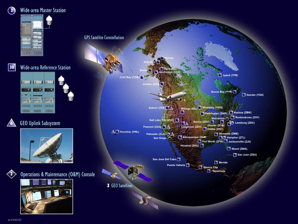

5 WAAS Infrastructure 5

6 WAAS Supported Operations 6


7 WAAS Coverage Note: Plots are of LPV availability not LPV IOC LPV Coverage in lower 48 states only 2008 Coverage - Full LPV 200 Coverage in CONUS (2 Satellites) 2015 Coverage - Full LPV 200 Coverage in CONUS (3 Satellites) 7

8 WAAS RNP 0.3 and RNP 0.1 Coverage 8
9 WAAS Development Phases Phase I: IOC (July 2003) Completed Provided LNAV/VNAV/Limited LPV Capability Phase II: Full LPV (FLP) ( ) Completed Improved LPV availability in CONUS and Alaska Expanded WAAS coverage to Mexico and Canada Implemented new WRSs in these countries which increased the number of ionospheric measurements at the edge of WAAS service volume New GEOs implemented with improved ranging performance. This provided increased continuity and availability for WAAS operations. Phase III: Full LPV-200 Performance ( ) Completed Improve performance during moderate ionospheric activity Implemented Kriging to reduce conservatism in models and increase availability Preparation for GPS L5 transition Phase IV: Dual Frequency (L1,L5) Operations ( ) Sustain WAAS GEOs Technology refresh to address equipment obsolescence Infrastructure modifications to support future L1/L5 user capability Transition from use of L2 P(Y) to L5 in WAAS and provide dual-frequency service Planning to transition within 2 years of GPS L5-signal Full Operational Capability (FOC) 9
 In May 2014 WAAS Final Investment Decision for Phase IV Segment 1 Dual Frequency Operations (DFO) was approved Segment 1 -")
10 Dual Frequency Operations Sunset of L2 P(Y) semi-codeless technique compels WAAS to use another signal to maintain current service USG Federal Register Notice identified sunset in December 2020 L2C/L5 readiness dates slipping (updates in Federal Radio-navigation Plan) In May 2014 WAAS Final Investment Decision for Phase IV Segment 1 Dual Frequency Operations (DFO) was approved Segment 1 - Develop infrastructure improvements to support L5 & Tech Refresh Segment 2 - Implementation of L1/L5 user capability 10

11 Current SBAS Availability 11

12 SBAS Availability w/ L1/L5 User 12
13 Ionospheric Effects on WAAS 13
14 PRN 29 Maintenance WAAS Performance Analysis Report, Report #52, Apr Elevated Geomagnetic Activity 14

15 Elevated Geomagnetic Activity WAAS Performance Analysis Report, Report #52, Apr

16 WAAS Performance Analysis Report, Report #52, Apr
17 WAAS Performance Analysis Report, Report #52, Apr
18 Future Planning 18
19 WAAS Phase IV Investigations Dual-Frequency Multi-constellation Capability International focus is on taking advantage of other GPS like constellations International Civil Aviation Organization (ICAO) Navigation Systems Panel (NSP) has developed work plan that supports development of future standards for use of other Global Navigation Satellite Systems (GNSS) ICAO working on CONOPS addressing all DFMC applications (e.g. SBAS, GBAS) User equipment standards for Dual-Frequency operations FAA working with SBAS Interoperability Working Group (IWG) on definition document that provides the basis for interface design and MOPS development for L1/L5 and multi-constellation Advanced RAIM (ARAIM) Avionics-centric approach to dual-frequency multi-constellation ARAIM subgroup developing more detailed concept definition Will be used to coordinate standards development with ICAO, RTCA and EUROCAE Updated Milestone 2b report analysis and conclusions based on public feedback and incorporate in Milestone 3 report at meeting held the week of March 23 rd 2015 The Milestone 2b report to be published at following meeting when formal review cycle completes 19
20 User Segment Update 20


 Ex.")
21 Users Depending on WAAS Approximately 82,000 WAAS equipped aircraft in the NAS WAAS receivers provided by companies such as: Garmin, Universal, Rockwell Collins, Honeywell, Avidyne, Innovative Solutions & Support (IS&S), Thales and Genesys Aerosystem (Chelton) Since 2006, aircraft equipage rates has increased each year Smaller airports and communities they serve are within reach, even in low visibility weather conditions All classes of aircraft are served in all phases of flight Enabling technology for NextGen programs Automatic Dependent Surveillance Broadcast (ADS-B) Performance Based Navigation (PBN) Ex. - Area Navigation (RNAV), Required Navigation Performance (RNP), and Point in Space (PinS) procedures 21


22 Airports with WAAS LPV/LP Instrument Approaches As of March 5, ,120 LP/LPVs combined - 3,534 LPVs serving 1,726 Airports LPV-200 s - 2,395 LPVs to Non-ILS Runways - 1,139 LPVs to ILS runways - 1,638 LPVs to Non-ILS Airports LPs serving 423 Airports LPs to Non-ILS Runway - 3 LPs to ILS Runways 22


23 23
24 Backup Slides 24
25 Federal Register Notice L1/L2 Sunset In 2008 the Office of Space Commercialization produced a Federal Register Notice detailing the U.S. Government's plan to phase out codeless and semi-codeless [L2 P(Y)] access to GPS by 31 December 2020 FAA concern with the elimination of L2 P(Y) semi-codeless relationship prior to ability to transition to the new L5 signal Federal Radionavigation Plan (FRP) is under revision Expect 2014 FRP language to support WAAS transition schedule DoD GPS satellite launch plans continue to delay FOC of L2C and L5 service New dates will be included in 2014 FRP 25
26 Legend Milestone Service Ended Service Started Satellite Development WAAS Schedule CY11 CY12 CY13 CY14 CY15 CY16 CY17 CY18 CY19 CY20 FAA Independent Activities SC Development Comm Upgrades G-III Receiver 7/15 1/13 5/16 G-III Test Circuits System-Wide 3/13 3/14 9/16 Development Production Fielding DFO and GEO Contracts GEO 5 GEO 6 GEO 7 AMR CRW CRE Reacquired Base Contract Complete 12/13 9/14 Dual Frequency Segment 1 Segment 2 DFO SIR DFO Award Eutelsat 117 West B (Satmex 9) 11/15 Base Contract Complete Option Years 7/17 7/17 10/17 Base Contract Complete

27 WAAS Enables Performance Based Navigation 27

28 Current WAAS GEO Coverage 28

29 WAAS Performance Analysis Report, Report #52, Apr
GPS/WAAS Program Update
 GPS/WAAS Program Update UN/Argentina Workshop on the Applications of GNSS 19-23 March 2018 Cordoba, Argentina GNSS: A Global Navigation Satellite System of Systems Global Constellations GPS (24+3) GLONASS
FAA GNSS Programs & GPS Evolutionary Architecture Study (GEAS) Status
 Status") FAA GNSS Programs & GPS Evolutionary Architecture Study (GEAS) Status Presented to: By: Date: Leo Eldredge, FAA Agenda Wide Area Augmentation System (WAAS) Status Local Area Augmentation System (LAAS)
FAA GNSS Programs & GPS Evolutionary Architecture Study (GEAS) Status Presented to: By: Date: Leo Eldredge, FAA Agenda Wide Area Augmentation System (WAAS) Status Local Area Augmentation System (LAAS)
GPS/GNSS What is it? How Does it Work? What are its Applications?
 GPS/GNSS What is it? How Does it Work? What are its Applications? Historic Navigation Reference points in the sky used for navigation The Sun The Pole Star / North Star Southern Cross Gives Direction,
HORIZONTAL ARAIM AVAILABILITY FOR CIVIL AVIATION OPERATIONS. ARAIM Outreach event
 HORIZONTAL ARAIM AVAILABILITY FOR CIVIL AVIATION OPERATIONS ARAIM Outreach event Moses1978 copyright April 7, 2017 H-ARAIM availability for civil aviation operations 07/04/2017 1 INTRODUCTION Space Segment
Final Project Report. Abstract. Document information
 Final Project Report Document information Project Title Multi-constellation GNSS Airborne Navigation Systems Project Number 09.27 Project Manager Thales Avionics Deliverable Name Final Project Report Deliverable
D. Salos, M. Mabilleau (Egis) C. Rodriguez, H. Secretan, N. Suard (CNES)
 C. Rodriguez, H. Secretan, N. Suard (CNES)") ITSNT 2017 - SBAS DFMC performance analysis with the SBAS DSVP 15/11/2017 1 ITSNT 2017 15/11/2017 Toulouse S B A S DUAL- F R E Q U E N C Y M U LT I - C O N S T E L L AT I O N ( D F M C ) A N A LY S I S
ITSNT 2017 - SBAS DFMC performance analysis with the SBAS DSVP 15/11/2017 1 ITSNT 2017 15/11/2017 Toulouse S B A S DUAL- F R E Q U E N C Y M U LT I - C O N S T E L L AT I O N ( D F M C ) A N A LY S I S
Aviation Benefits of GNSS Augmentation
 Aviation Benefits of GNSS Augmentation Workshop on the Applications of GNSS Chisinau, Moldova 17-21 May 2010 Jeffrey Auerbach Advisor on GNSS Affairs Office of Space and Advanced Technology U.S. Department
Special Committee SC-159 Navigation Equipment Using the Global Navigation Satellite System (GNSS) (Version 11)
 (Version 11)") RTCA Paper No. 094-18/PMC-1737 March 22, 2018 TERMS OF REFERENCE Special Committee SC-159 Navigation Equipment Using the Global Navigation Satellite System (GNSS) (Version 11) REQUESTOR: Organization Person
RTCA Paper No. 094-18/PMC-1737 March 22, 2018 TERMS OF REFERENCE Special Committee SC-159 Navigation Equipment Using the Global Navigation Satellite System (GNSS) (Version 11) REQUESTOR: Organization Person
GA and NextGen How technologies like WAAS and ADS-B will change your flying! Presented By Claire Kultgen
 GA and NextGen How technologies like WAAS and ADS-B will change your flying! Presented By Claire Kultgen Overview 1. TIS 2. ADS-B FIS-B TIS-B ADS-R 3. WAAS 4. T-Routes and GPS MEAs Questions Chat Pilot
GNSS: CNS Dependencies
 GNSS: CNS Dependencies Lendina Smaja DATM/RDS/NAV 10 March 2015 Agenda The Future Technical Environment GNSS GNSS Supporting CNS Loss of Signal Impact GNSS: CNS Dependencies 2 Original FANS CNS/ATM Concept
Special Committee SC-159 Navigation Equipment Using the Global Navigation Satellite System (GNSS) (Version 13)
 (Version 13)") RTCA Paper No. 307-18/PMC-1839 December 13, 2018 TERMS OF REFERENCE Special Committee SC-159 Navigation Equipment Using the Global Navigation Satellite System (GNSS) (Version 13) REQUESTOR: Organization
RTCA Paper No. 307-18/PMC-1839 December 13, 2018 TERMS OF REFERENCE Special Committee SC-159 Navigation Equipment Using the Global Navigation Satellite System (GNSS) (Version 13) REQUESTOR: Organization
IMPLEMENTATION OF GNSS BASED SERVICES
 International Civil Aviation Organization IMPLEMENTATION OF GNSS BASED SERVICES Julio Siu Communications, Navigation and Surveillance Regional Officer ICAO NACC Regional Office ICAO Workshop on PBN Airspace
Horizontal Advanced RAIM: Operational Benefits and Future Challenges
 Horizontal Advanced RAIM: Operational Benefits and Future Challenges International Technical Symposium on Navigation and Timing 2015 Session Air Navigation November 2015 Toulouse/France 1 ICAO ABAS augmentation
Galileo & EGNOS Programmes Status
 Galileo & EGNOS Programmes Status Ugo Celestino, European Commission EURO-MEDITERRANEAN TRANSPORT FORUM GNSS WORKING GROUP 16 th October 2012 17 October, 2012 The European GNSS Programmes 2 Table of contents
The Wide Area Augmentation System (WAAS)
") The Wide Area Augmentation System (WAAS) Stanford University http://waas.stanford.edu !Aviation Metrics Outline!GPS/Aviation Timelines!The Wide-Area Augmentation System!Integrity Analyses!Comparison with
The Wide Area Augmentation System (WAAS) Stanford University http://waas.stanford.edu !Aviation Metrics Outline!GPS/Aviation Timelines!The Wide-Area Augmentation System!Integrity Analyses!Comparison with
SBAS solution GCC, Yemen and Iraq System baseline and performance
 SBAS solution GCC, Yemen and Iraq System baseline and performance ACAC Workshop Rabat 7 & 8 November 2017 1 2017 Thales Alenia Space PROPRIETARY C O M MINFORMATION E R C I A L I N THALES C O ALENIA N F
CONCEPT OF OPERATIONS (CONOPS) FOR DUAL-FREQUENCY MULTI-CONSTELLATION (DFMC) GLOBAL NAVIGATION SATELLITE SYSTEM (GNSS)
 FOR DUAL-FREQUENCY MULTI-CONSTELLATION (DFMC) GLOBAL NAVIGATION SATELLITE SYSTEM (GNSS)") CONCEPT OF OPERATIONS (CONOPS) FOR DUAL-FREQUENCY MULTI-CONSTELLATION (DFMC) GLOBAL NAVIGATION SATELLITE SYSTEM (GNSS) Prepared by the ICAO Navigation Systems Panel CONOPS V6.4 Page 1 of 49 27 April 2018
CONCEPT OF OPERATIONS (CONOPS) FOR DUAL-FREQUENCY MULTI-CONSTELLATION (DFMC) GLOBAL NAVIGATION SATELLITE SYSTEM (GNSS) Prepared by the ICAO Navigation Systems Panel CONOPS V6.4 Page 1 of 49 27 April 2018
GPS Civil Service Update & U.S. International GNSS Activities
 GPS Civil Service Update & U.S. International GNSS Activities International GNSS (IGNSS) Conference Sydney, Australia Jeffrey Auerbach Office of Space and Advanced Technology U.S. Department of State 06
AEEC 2013 Presentation to the Airlines and the Aviation Industry
 AEEC 2013 Presentation to the Airlines and the Aviation Industry Multi-Frequency/Multi-Constellation (MFMC) GNSS Receivers Value for Aviation and Airlines John Studenny CMC GPS Product Manager Alain Beaulieu
SATELLITE BASED AUGMENTATION SYSTEM (SBAS) FOR AUSTRALIA
 FOR AUSTRALIA") SATELLITE BASED AUGMENTATION SYSTEM (SBAS) FOR AUSTRALIA AN AIN POSITION PAPER SUBMITTED TO VARIOUS GOVERNMENT DEPARTMENTS BY MR KYM OSLEY AM, CSC, EXEC SECRETARY AIN What are GNSS Augmentation Systems?
SATELLITE BASED AUGMENTATION SYSTEM (SBAS) FOR AUSTRALIA AN AIN POSITION PAPER SUBMITTED TO VARIOUS GOVERNMENT DEPARTMENTS BY MR KYM OSLEY AM, CSC, EXEC SECRETARY AIN What are GNSS Augmentation Systems?
Satellite-Based Augmentation System (SBAS) Integrity Services
 Integrity Services") Satellite-Based Augmentation System (SBAS) Integrity Services Presented To: Munich, Germany Date: March 8, 2010 By: Leo Eldredge, Manager GNSS Group, FAA FAA Satellite Navigation Program 2 Wide Area Augmentation
Satellite-Based Augmentation System (SBAS) Integrity Services Presented To: Munich, Germany Date: March 8, 2010 By: Leo Eldredge, Manager GNSS Group, FAA FAA Satellite Navigation Program 2 Wide Area Augmentation
Summary of the Ninety-Fifth Meeting. Special Committee 159
 RTCA Paper No. 189-16/SC159-1050 August 8, 2016 Summary of the Ninety-Fifth Meeting Special Committee 159 Minimum Operational Performance Standards for Airborne Navigation Equipment Using the Global Positioning
Navigation Programs Strategy
 Change History Revision Effective Sections Changes Made Date Affected 1.0 01/12/2018 Initial Release ii Preface This Navigation Programs Strategy document contains the FAA s plan to provide navigation
SBAS DFMC performance analysis with the SBAS DFMC Service Volume software Prototype (DSVP)
") SBAS DFMC performance analysis with the SBAS DFMC Service Volume software Prototype (DSVP) D. Salos, M. Mabilleau, Egis Avia C. Rodriguez, H. Secretan, N. Suard, CNES (French Space Agency) Email: Daniel.salos@egis.fr
SBAS DFMC performance analysis with the SBAS DFMC Service Volume software Prototype (DSVP) D. Salos, M. Mabilleau, Egis Avia C. Rodriguez, H. Secretan, N. Suard, CNES (French Space Agency) Email: Daniel.salos@egis.fr
Seminar on the Ionosphere and its Effects on GNSS Systems (Project RLA/00/009 GNSS Augmentation Trials) (Santiago, Chile, April 2008) AGENDA
 (Santiago, Chile, April 2008) AGENDA") Monday, 14 April 2008 Seminar on the Ionosphere and its Effects on GNSS Systems (Project RLA/00/009 GNSS Augmentation Trials) (Santiago, Chile, 14-16 April 2008) AGENDA REGISTRATION OF PARTICIPANTS AND
Monday, 14 April 2008 Seminar on the Ionosphere and its Effects on GNSS Systems (Project RLA/00/009 GNSS Augmentation Trials) (Santiago, Chile, 14-16 April 2008) AGENDA REGISTRATION OF PARTICIPANTS AND
What s up with WAAS?
 I N D U S T RY What s up with WAAS? There s a bright new star in the GPS constellation and pretty soon every bright pilot is going to want to use it. B Y D A L E S M I T H You probably didn t notice it
Modernizing WAAS. Todd Walter and Per Enge, Stanford University, Patrick Reddan Zeta Associates Inc.
 Modernizing WAAS Todd Walter and Per Enge, Stanford University, Patrick Reddan Zeta Associates Inc. ABSTRACT The Wide Area Augmentation System (WAAS) became operational on July 10, 003. Currently this
Introduc)on to GNSS Integrity & Space- Based Augmenta)on Systems
on to GNSS Integrity & Space- Based Augmenta)on Systems") Introduc)on to GNSS Integrity & Space- Based Augmenta)on Systems for GNSS Technologies Advances in a Mul)- constella)on Framework Sogei S.p.A., Roma by Per Enge April 22 & 23, 2013 History of GPS Service
Introduc)on to GNSS Integrity & Space- Based Augmenta)on Systems for GNSS Technologies Advances in a Mul)- constella)on Framework Sogei S.p.A., Roma by Per Enge April 22 & 23, 2013 History of GPS Service
Alternate Position, Navigation & Time APNT for Civil Aviation
 Alternate Position, Navigation & Time APNT for Civil Aviation For Working Group B of the International GNSS Committee Shanghai, May 2011 by Per Enge & Leo Eldredge Work supported by the Federal Aviation
Vertical Guidance Performance Analysis of the L1-L5 Dual-Frequency GPS/WAAS User Avionics Sensor
 Sensors 010, 10, 9-65; doi:10.3390/s1009 OPEN ACCESS sensors ISSN 144-80 www.mdpi.com/journal/sensors Article Vertical Guidance Performance Analysis of the L1-L5 Dual-Frequency GPS/WAAS User Avionics Sensor
Modern ARINC 743B DO-229D and DO-253C GLSSU Solutions For Retrofit
 Commercial Aviation Modern ARINC 743B DO-229D and DO-253C GLSSU Solutions For Retrofit Presented to AEEC March 2010 The Classic Retrofit Challenge Financial: Operating budget year financing ROI payback:
REPORT OF COMMITTEE B TO THE CONFERENCE ON AGENDA ITEM 6
 1/10/03 ELEVENTH AIR NAVIGATION CONFERENCE Montreal, 22 September to 3 October 2003 REPORT OF COMMITTEE B TO THE CONFERENCE ON AGENDA ITEM 6 The attached report has been approved by Committee B for submission
ICAO policy on GNSS, GNSS SARPs and global GNSS developments. Jim Nagle Chief, Communication, Navigation and Surveillance Section ICAO
 ICAO policy on GNSS, GNSS SARPs and global GNSS developments Jim Nagle Chief, Communication, Navigation and Surveillance Section ICAO Presentation overview Introduction GNSS developments in ICAO ICAO policy
GBAS FOR ATCO. June 2017
 GBAS FOR ATCO June 2017 Disclaimer This presentation is for information purposes only. It should not be relied on as the sole source of information, and should always be used in the context of other authoritative
Recent Progress on Aviation Integrity
 Recent Progress on Aviation Integrity for the Institute of Navigation on September 17, 2008 by Per Enge, Stanford University Acknowledgement: This work was sponsored by the FAA Satellite Navigation Office
One Decade of WAAS Lessons - How Would We Have Done It Differently, If Given Another Chance
 One Decade of WAAS Lessons - How Would We Have Done It Differently, If Given Another Chance Tim Schempp, WAAS Technical Director Dr. Kenneth Kung, Sr. Principal Engineering Fellow November 18, 2011 The
INTERNATIONAL CIVIL AVIATION ORGANIZATION
 INTERNATIONAL CIVIL AVIATION ORGANIZATION AFI PLANNING AND IMPLEMENTATION REGIONAL GROUP EIGHTEENTH MEETING (APIRG/18) Kampala, Uganda (27 30 March 2012) Agenda Item 3: Performance Framework for Regional
IMPLEMENTATION OF AN SBAS-SACCSA TEST BED IN THE CAR/SAM REGIONS. (Presented by the Secretariat) SUMMARY
 SUMMARY") RLA/03/902 RCC/9 - WP/10 12/06/13 International Civil Aviation Organization South American Regional Office - Project RLA/03/902 Transition to GNSS/SBAS in the CAR/SAM Regions SACCSA Phase III Ninth Meeting
RLA/03/902 RCC/9 - WP/10 12/06/13 International Civil Aviation Organization South American Regional Office - Project RLA/03/902 Transition to GNSS/SBAS in the CAR/SAM Regions SACCSA Phase III Ninth Meeting
ICG GNSS Interoperability Workshop A Civil Aviation Perspective
 Approved for Public Release; Distribution Unlimited. 13-1907. ICG GNSS Interoperability Workshop A Civil Aviation Perspective C h r i s t o p h e r J. H e g a r t y A p r i l 2 0 1 3 Disclaimer: The contents
RESULTS OF THE REGIONAL SBAS TEST BED TYPE WAAS PROYECT RLA/00/009. Onofrio Smarrelli ICAO SAM CNS Lima Regional Office
 WORKSHOP / SEMINAR FOR THE IMPLEMENTATION OF NAVIGATION INFRASTRUCTURE TO SUPPORT PBN AND GNSS PRECISION APPROACH OPERATIONS IN THE NAM CAR SAM REGION (Lima, Peru 15 to 17 August 2016 ) RESULTS OF THE
> ATM Seminar 2015 > Dauterrmann/Geister 376 >
 DLR.de Chart 1 Combining Advanced-RNP with SBAS Guided Precision Terminal Area Paths and Final Approach Guidance Exploiting All Benefits from Performance Based Navigation Thomas Dautermann and Robert Geister
AERONAUTICAL COMMUNICATIONS PANEL (ACP) FIRST MEETING OF THE WORKING GROUP OF THE WHOLE. Montreal, Canada JUNE 2005
 FIRST MEETING OF THE WORKING GROUP OF THE WHOLE. Montreal, Canada JUNE 2005") International Civil Aviation Organization WORKING PAPER ACP-WGW01/WP36 21/06/05 AERONAUTICAL COMMUNICATIONS PANEL (ACP) FIRST MEETING OF THE WORKING GROUP OF THE WHOLE Montreal, Canada 21 29 JUNE 2005
International Civil Aviation Organization WORKING PAPER ACP-WGW01/WP36 21/06/05 AERONAUTICAL COMMUNICATIONS PANEL (ACP) FIRST MEETING OF THE WORKING GROUP OF THE WHOLE Montreal, Canada 21 29 JUNE 2005
Radio Navigation Aids Flight Test Seminar
 Radio Navigation Aids Flight Test Seminar FLIGHT INSPECTION IN THE NEW MILLENNIUM Curt Keedy FAA Flight Inspection Policy and Standards Change, Challenge, and Opportunity CHANGES Global Positioning system
Performance framework for Regional Air Navigation Planning and Implementation
 GREPECAS/16 WP/21 International Civil Aviation Organization 02/03/11 CAR/SAM Regional Planning and Implementation Group (GREPECAS) Sixteenth Meeting of the CAR/SAM Regional Planning and Implementation
On Location at Stanford University
 Thank you for inviting me to Calgary On Location at Stanford University by Per Enge (with the help of many) May 29, 2009 With Gratitude to the Federal Aviation Administration from Misra and Enge, 2006
Ground Based Augmentation Systems (GBAS) Introduction
 Introduction") Ground Based Augmentation Systems (GBAS) Introduction Technical and Operational Overview Andreas Lipp GBAS Implementation Workshop, ICAO EUR/NAT Paris, 18 March 2010 The European Organisation for the Safety
Ground Based Augmentation Systems (GBAS) Introduction Technical and Operational Overview Andreas Lipp GBAS Implementation Workshop, ICAO EUR/NAT Paris, 18 March 2010 The European Organisation for the Safety
DFMC SBAS Receiver Development. Please note that this presentation is also published on the GSA website
 DFMC SBAS Receiver Development Please note that this presentation is also published on the GSA website DFMC SBAS Receiver Prototype Objective This DFMC SBAS Receiver Prototype activity is envisaged by
Overview of GNSS Navigation Sources, Augmentation Systems, and Applications
 Overview of GNSS Navigation Sources, Augmentation Systems, and Applications The Ionosphere and its Effects on GNSS Systems 14 to 16 April 2008 Santiago, Chile Dr. S. Vincent Massimini Global Navigation
Latest Evolution of RAIM Prediction Systems
 Latest Evolution of RAIM Prediction Systems SPACEKEYS is a project funded by the European Space Agency SPACEKEYS 2018. All rights reserved. Topics Rationale Requirements Objectives Results Achievements
Introduction to PBN and RNP
 Introduction to PBN and RNP Rick Farnworth ATM/RDS/NAV SDM PBN workshop 19 th October 2017 Summary What is PBN? Some History The ICAO PBN Manual The Benefits of PBN Some Examples PBN Approaches PBN and
Proceedings of Al-Azhar Engineering 7 th International Conference Cairo, April 7-10, 2003.
 Proceedings of Al-Azhar Engineering 7 th International Conference Cairo, April 7-10, 2003. MODERNIZATION PLAN OF GPS IN 21 st CENTURY AND ITS IMPACTS ON SURVEYING APPLICATIONS G. M. Dawod Survey Research
GNSS Spectrum Issues and New GPS L5
 Federal Aviation Administration Washington, D.C. GNSS Spectrum Issues and New GPS L5 International Civil Aviation Organization Regional Coordination Meeting Lima, Peru March 27 28, 2001 Basic GPS System!Space
Near Term Improvements to WAAS Availability
 Near Term Improvements to WAAS Availability Juan Blanch, Todd Walter, R. Eric Phelts, Per Enge Stanford University ABSTRACT Since 2003, when it was first declared operational, the Wide Area Augmentation
Nigerian Communications Satellite Ltd. (NIGCOMSAT)
") OVERVIEW OF NIGERIAN SATELLITE AUGMENTATION SYSTEM COMMENCING WITH PILOT DEMONSTRATION TO VALIDATE NATIONAL WORK PLAN presented by Dr. Lawal Lasisi Salami, NIGERIAN COMMUNICATIONS SATELLITE LTD UNDER FEDERAL
OVERVIEW OF NIGERIAN SATELLITE AUGMENTATION SYSTEM COMMENCING WITH PILOT DEMONSTRATION TO VALIDATE NATIONAL WORK PLAN presented by Dr. Lawal Lasisi Salami, NIGERIAN COMMUNICATIONS SATELLITE LTD UNDER FEDERAL
Ionospheric Corrections for GNSS
 Ionospheric Corrections for GNSS The Atmosphere and its Effect on GNSS Systems 14 to 16 April 2008 Santiago, Chile Ing. Roland Lejeune Overview Ionospheric delay corrections Core constellations GPS GALILEO
Report of Working Group B: Enhancement of Global Navigation Satellite Systems Services Performance
 Report of : Enhancement of Global Navigation Satellite Systems Services Performance 1. The Working Group on Enhancement of Global Navigation Satellite Systems (GNSS) Service Performance (WG-B) of the International
Alternative PNT: What comes after DME?
 Alternative PNT: What comes after DME? Gerhard Berz, Valeriu Vitan, EUROCONTROL Luca Saini, Thales Air Systems Mike Spanner, NATS 20 th International Flight Inspection Symposium (IFIS) Monterey CA, USA,
ICAO Global Provisions and Regional Developments related to GNSS
 ICAO Global Provisions and Regional Developments related to GNSS Mohamed Smaoui ICAO Deputy Regional Director, Middle East Office, Cairo, Egypt Rabat, Morocco, 7 8 November 2017 OUTLINE Introduction GNSS
On Location at Stanford University
 Thank you for inviting me (back) to Deutsches Zentrum für Luft- und Raumfahrt On Location at Stanford University by Per Enge (with the help of many) July 27, 2009 My thanks to the Federal Aviation Administration
Status of ARAIM. S. Wallner ICG 6, Tokyo, Japan 05/09/2011. ESA UNCLASSIFIED For Official Use
 Status of ARAIM S. Wallner ICG 6, Tokyo, Japan 05/09/2011 ARAIM Concept Objectives Classical GPS RAIM for NPA used since years Evolving GNSS environment Multi-GNSS GPS/Galileo/Glonass/Compass/QZSS Dual-frequency
Alternative Positioning, Navigation & Timing (APNT) Study Update
 Study Update") Alternative Positioning, Navigation & Timing (APNT) Study Update Why APNT? The transformation of the National Airspace System (NAS) to the Next Generation Air Transportation System (NextGen) relies on
Alternative Positioning, Navigation & Timing (APNT) Study Update Why APNT? The transformation of the National Airspace System (NAS) to the Next Generation Air Transportation System (NextGen) relies on
Prototyping Advanced RAIM for Vertical Guidance
 Prototyping Advanced RAIM for Vertical Guidance Juan Blanch, Myung Jun Choi, Todd Walter, Per Enge. Stanford University Kazushi Suzuki. NEC Corporation Abstract In the next decade, the GNSS environment
Final Project Report. Abstract. Document information
 Final Project Report Document information Project Title GNSS Baseline Study Project Number 15.03.04 Project Manager LEONARDO Deliverable Name Final Project Report Deliverable ID D01 Edition 01.02.00 Template
An ARAIM Demonstrator
 An ARAIM Demonstrator D. Salos, M. Mabilleau, Egis Avia N. Dahman, Airbus Deference and Space S. Feng, Imperial College of London JP. Boyero, European Commission Email: daniel.salos@egis.fr BIOGRAPHIES
Global Positioning Systems Directorate
 Space and Missile Systems Center Global Positioning Systems Directorate GPS Program Update to 8 th Stanford PNT Symposium 30 Oct 2014 Col Matt Smitham Deputy Director, GPS Directorate Global Positioning
Status Report of Switzerland
 Status Report of Switzerland Marc Troller CNS expert group, skyguide Romano Germann IFP expert group, skyguide Agenda Overview PBN Implementation Status Swiss AIP Change GNSS Interference Detection Method
Development of Satellite Navigation for Aviation (FAA Award No. 95-G-005) Technical Description of Project and Results Stanford University June 2009
 Technical Description of Project and Results Stanford University June 2009") 1.0 Introduction Development of Satellite Navigation for Aviation (FAA Award No. 95-G-005) Technical Description of Project and Results Stanford University June 2009 This report describes the key elements
1.0 Introduction Development of Satellite Navigation for Aviation (FAA Award No. 95-G-005) Technical Description of Project and Results Stanford University June 2009 This report describes the key elements
DEFINING THE FUTURE OF SATELLITE SURVEYING WITH TRIMBLE R-TRACK TECHNOLOGY
 DEFINING THE FUTURE OF SATELLITE SURVEYING WITH TRIMBLE R-TRACK TECHNOLOGY EDMOND NORSE, GNSS PORTFOLIO MANAGER, TRIMBLE SURVEY DIVISION WESTMINSTER, CO USA ABSTRACT In September 2003 Trimble introduced
RAIM Availability prediction
 RAIM Availability prediction Main content 一 Background & research purposes 二 Related research in China and abroad 三 Theory and arithmetic 四 RAIM systems development 五 The vision of the future 1 Background
PBN fleet equipage according to FPL content. Michel ROELANDT
 PBN fleet equipage according to FPL content Michel ROELANDT EUROCONTROL RAiSG/PBN TF Meeting March 2014 Introduction 15 Nov 2012: standard ICAO format for airline flight plans changed. New fields have
The Wide Area Augmentation System
 The Wide Area Augmentation System Stanford University http://waas.stanford.edu What is Augmentation? 2 Add to GNSS to Enhance Service Improve integrity via real time monitoring Improve availability and
Preparatory paper: food for thought
 CNS SYMPOSIUM 2-3 October 2018 EUROCONTROL s Brussels HQ Preparatory paper: food for thought 1 Introduction EUROCONTROL will host a two-day interactive CNS Symposium on October 2 nd and 3 rd, 2018. This
ICAO PBN GO TEAM PBN Implementation Workshop ENAC / ATM
 ICAO PBN GO TEAM PBN Implementation Workshop Minsk, BELARUS, 7-10 April 2015 ENAC / ATM Bertrand FOUCHER 1 PERSONAL BACKGROUND ATCO in Paris Charles de Gaulle ATC Supervisor in Paris Charles de Gaulle,
Navy Landing System Overview
 Navy Landing System Overview OPNAV N8853 CDR Brett Bucket Easler 1 Interoperable Solution USN Automatic Carrier Landing System (SPN-46) LHA/D Landing System (SPN-35) Shore Precision Approach Radar (PAR)
ARAIM Fault Detection and Exclusion
 ARAIM Fault Detection and Exclusion Boris Pervan Illinois Institute of Technology Chicago, IL November 16, 2017 1 RAIM ARAIM Receiver Autonomous Integrity Monitoring (RAIM) uses redundant GNSS measurements
CONSIDERATIONS FOR GNSS MEASUREMENTS
 CONSIDERATIONS FOR GNSS MEASUREMENTS Cornel PĂUNESCU 1, Cristian VASILE 2, Cosmin CIUCULESCU 3 1 PhD University of Bucharest, e-mail: cornelpaun@gmail.com 2 Lecturer PhD University of Craiova, cristi_vasile_4you@yahoo.com
GPS with RAIM or EGNOS? The difference for (mountainous) helicopter operations. Marc Troller Skyguide / CNS expert group
 helicopter operations. Marc Troller Skyguide / CNS expert group") GPS with RAIM or EGNOS? The difference for (mountainous) helicopter operations Marc Troller Skyguide / CNS expert group 1 Motivation for Dedicated Helicopter Procedures Swiss GNSS LFN network: Mandate
GPS with RAIM or EGNOS? The difference for (mountainous) helicopter operations Marc Troller Skyguide / CNS expert group 1 Motivation for Dedicated Helicopter Procedures Swiss GNSS LFN network: Mandate
GAGAN-Extension to the Gulf Region. Joint ACAC/ICAO MID Workshop on GNSS 7 th & 8 th November 2017
 GAGAN-Extension to the Gulf Region Joint ACAC/ICAO MID Workshop on GNSS 7 th & 8 th November 2017 P.N.S. KUSHWAHA EXECUTIVE DIRECTOR (CNS P) Airports Authority of India New Delhi Topics covered : 1. GAGAN
ELEVENTH AIR NAVIGATION CONFERENCE. Montreal, 22 September to 3 October 2003 TOOLS AND FUNCTIONS FOR GNSS RAIM/FDE AVAILABILITY DETERMINATION
 19/9/03 ELEVENTH AIR NAVIGATION CONFERENCE Montreal, 22 September to 3 October 2003 Agenda Item 6 : Aeronautical navigation issues TOOLS AND FUNCTIONS FOR GNSS RAIM/FDE AVAILABILITY DETERMINATION (Presented
GAGAN implementation and certification Programme. Presented by India
 GAGAN implementation and certification Programme Presented by India GPS Aided Geo Augmented Navigation International Civil Aviation Organization (ICAO) Member States Endorsed Global Satellite Navigation
GPS Status and Modernization
 GPS Status and Modernization Nov 2011 Colonel Harold Martin PNT Command Lead AFSPC A3P "This briefing is for information only. No US Government commitment to sell, loan, lease, co-develop or co-produce
PBN Operational Approval Course
 PBN Operational Approval Course Introduction and Overview PBN Operations Approval Welcome Logistics Introductions PBN Overview 2 Instructor Bob Kennedy Attendees: 3 Course Objectives The objective of this
L1/L5 SBAS MOPS to Support Multiple Constellations
 L1/L5 SBAS MOPS to Support Multiple Constellations Todd Walter, Juan Blanch, and Per Enge, Stanford University ABSTRACT This paper proposes a message structure for the L5 GEO data signal that can support
Summary of the Ninety-Second Meeting. Special Committee 159
 RTCA Paper No. 229-14/SC159-1022 February 26, 2015 Summary of the Ninety-Second Meeting Special Committee 159 Minimum Operational Performance Standards for Airborne Navigation Equipment Using the Global
Assessment of GNSS Ionospheric Scintillation and TEC Monitoring Using the Multi-constellation GPStation-6 Receiver
 Assessment of GNSS Ionospheric Scintillation and TEC Monitoring Using the Multi-constellation GPStation-6 Receiver Rod MacLeod Regional Manager Asia/Pacific NovAtel Australia Pty Ltd Outline Ionospheric
INTEGRITY AND CONTINUITY ANALYSIS FROM GPS JULY TO SEPTEMBER 2016 QUARTERLY REPORT
 INTEGRITY AND CONTINUITY ANALYSIS FROM GPS JULY TO SEPTEMBER 2016 QUARTERLY REPORT Name Responsibility Date Signature Prepared by M Pattinson (NSL) 07/10/16 Checked by L Banfield (NSL) 07/10/16 Authorised
Figure 2: Maximum Ionosphere-Induced Vertical Errors at Memphis
 277 Figure 2: Maximum Ionosphere-Induced Vertical Errors at Memphis 278 Figure 3: VPL Inflation Required to Remove Unsafe Geometries 279 280 Figure 4: Nominal IPP Scenario All Surrounding IGPs are Good
International Civil Aviation Organization THE SIXTH MEETING OF IONOSPHERIC STUDIES TASK FORCE (ISTF/6) OUTCOME OF THE NSP/2 MEETING
 OUTCOME OF THE NSP/2 MEETING") ISTF/6 WP/06 Agenda Item 2 15/01/16 International Civil Aviation Organization THE SIXTH MEETING OF IONOSPHERIC STUDIES TASK FORCE (ISTF/6) Bangkok, Thailand, 19 21 January 2016 Agenda Item 2: Review of
ISTF/6 WP/06 Agenda Item 2 15/01/16 International Civil Aviation Organization THE SIXTH MEETING OF IONOSPHERIC STUDIES TASK FORCE (ISTF/6) Bangkok, Thailand, 19 21 January 2016 Agenda Item 2: Review of
GNSS for Landing Systems and Carrier Smoothing Techniques Christoph Günther, Patrick Henkel
 GNSS for Landing Systems and Carrier Smoothing Techniques Christoph Günther, Patrick Henkel Institute of Communications and Navigation Page 1 Instrument Landing System workhorse for all CAT-I III approach
Progress on Working Group-C Activities on Advanced RAIM
 Progress on Working Group-C Activities on Advanced RAIM Juan Blanch, Todd Walter, Per Enge. Stanford University Jason Burns, Ken Alexander Federal Aviation Administration Juan Pablo Boyero European Commission,
AIREON SPACE-BASED ADS-B
 AIREON SPACE-BASED ADS-B 2018 Transport Canada Delegates Conference Steve Bellingham Manager, Navigation Systems Engineering Steve.Bellingham@navcanada.ca CNS/ATM Systems Communication Navigation Surveillance
[EN A 78] Development of a CAT III GBAS (GAST D) ground subsystem prototype and its performance evaluation with a long term data set
![[EN A 78] Development of a CAT III GBAS (GAST D) ground subsystem prototype and its performance evaluation with a long term data set](/thumbs/96/128212036.jpg "[EN A 78] Development of a CAT III GBAS (GAST D) ground subsystem prototype and its performance evaluation with a long term data set") [EN A 78] Development of a CAT III GBAS (GAST D) ground subsystem prototype and its performance evaluation with a long term data set (EIWAC 2017) + T. Yoshihara*, S. Saito*, A. Kezuka*, K. Hoshinoo*, S.
[EN A 78] Development of a CAT III GBAS (GAST D) ground subsystem prototype and its performance evaluation with a long term data set (EIWAC 2017) + T. Yoshihara*, S. Saito*, A. Kezuka*, K. Hoshinoo*, S.
Global Navigation Satellite System (GNSS) GPS Serves Over 400 Million Users Today. GPS is used throughout our society
 GPS Serves Over 400 Million Users Today. GPS is used throughout our society") Global avigation Satellite System (GSS) For freshmen at CKU AA December 10th, 2009 by Shau-Shiun Jan ICA & IAA, CKU Global avigation Satellite System (GSS) GSS (Global Positioning System, GPS) Basics Today
Global avigation Satellite System (GSS) For freshmen at CKU AA December 10th, 2009 by Shau-Shiun Jan ICA & IAA, CKU Global avigation Satellite System (GSS) GSS (Global Positioning System, GPS) Basics Today
Excellence in Technical Solutions
 Excellence in Technical Solutions SUMARY Introduction IACIT s History Services and Products FINEP Financier of Studies and Projects GBAS IACIT Flexibility in compair with ILS Designed to Agree Perspectives
GPS Modernization and Program Update
 GPS Modernization and Program Update GPS Update to ION Southern California Chapter 22 Feb 2011 Colonel Bernie Gruber Director Global Positioning Systems Directorate Contents Current Constellation Modernization
Regional and Inter-Regional Seminar and Workshop on Search and Rescue
 Regional and Inter-Regional Seminar and Workshop on Search and Rescue Mahe, Seychelles 19-22 July 2016 1 Agenda Aireon Introduction Space-Based ADS-B Overview Aireon System Deployment Status Aireon ALERT
SPACE-BASED SOLUTIONS & ANALYTICS
 SPACE-BASED SOLUTIONS & ANALYTICS Enable development and optimisation of airspace use, and no aircraft to be lost again wherever on Earth C N S S y m p o s i u m E u r o c o n t r o l 2 & 3 O c t o b e
Operational Benefits of Ground Based Augmentation Systems
 Operational Benefits of Ground Based Augmentation Systems Airline Perspective Ron Renk Manager, Flight Technologies/ 737 Pilot Flight Operations June 15, 2011 Today s Program What is GBAS? Why Continental
Analysis of a Three-Frequency GPS/WAAS Receiver to Land an Airplane
 Analysis of a Three-Frequency GPS/WAAS Receiver to Land an Airplane Shau-Shiun Jan Department of Aeronautics and Astronautics Stanford University, California 94305 BIOGRAPHY Shau-Shiun Jan is a Ph.D. candidate
Global positioning system (GPS) equipment including those using GPS augmentations.
 equipment including those using GPS augmentations.") U.S. Department of Transportation Federal Aviation Administration Advisory Circular Subject: Airworthiness Approval of Positioning and Navigation Systems Date: 5/8/12 Initiated by: AIR-130 AC No: 20-138C
U.S. Department of Transportation Federal Aviation Administration Advisory Circular Subject: Airworthiness Approval of Positioning and Navigation Systems Date: 5/8/12 Initiated by: AIR-130 AC No: 20-138C