Een GPS naderingshulpmiddel voor de kleine luchtvaart
|
|
|
- Eunice Terry
- 5 years ago
- Views:
Transcription
1 Technische ontwikkelingen: Een GPS naderingshulpmiddel voor de kleine luchtvaart Christian Tiberius Faculteit Luchtvaart- en Ruimtevaarttechniek TU Delft WORKSHOP Is er nog Lucht(ruim) voor de Kleine Luchtvaart November 14, 2008 LVNL Schiphol Oost 1

2 satellite navigation: GPS initiated by US Department of Defense (DoD), operated by US Air Force (USAF) provide to US military: position - velocity time; civil use allowed control ground antenna MCS uplink monitor stations space user measure ranges to 4 satellites to determine: X, Y, Z and receiver clock offset X Z Y annual worldwide sales of GPS products and services: US$ 25 billion (2006) 2


3 sat-nav error sources satellite orbit & clock atmosphere ionosphere troposphere receiver noise + multipath Earth 3
4 GPS error budget (stand-alone) TU Delft values from experience GPS as of 2008 NOTE: with iono 50% can be corrected with Klobuchar model (broadcast parameters); with tropo 90% can be corrected with a-priori (blind) model; corrections assumed to be applied in above total range figure 4


5 The use of GPS is for free, We will continue to provide the GPS Standard Positioning Service for peaceful civil, commercial and scientific use on a continuous, worldwide basis, free of direct user fees. GPS Presidential Decision Directive, March 1996 but with little service and performance guarantees 5


6 augmented GPS: WADGPS use GPS information from external sources, e.g. a permanent tracking network across Europe goal: - improve accuracy - improve integrity Wide Area Differential GPS (WADGPS): e.g. WAAS, EGNOS, and MSAS 6
7 EUROCONTROL policy on GNSS navigation applications in civil aviation: gradually increasing reliance on satellite navigation, with final goal its use as sole service ION GNSS 2008 September 16-19, 2008 Savannah Georgia next 3 slides 7
 need for Galileo Safety-of-Life (SoL)")
8 GNSS policy EUROCONTROL = European Organisation for the Safety of Air Navigation primary objective: development of a seamless, pan-european Air Traffic Management system to proceed towards a successful transition to GNSS policy to be applied in SESAR (Single European Sky ATM Research) need for Galileo Safety-of-Life (SoL) service 8
9 GNSS policy The vision for the use of a multi-constellation and multi-frequency GNSS in This EUROCONTROL policy on GNSS is based on a gradually increasing reliance on satellite navigation that has as the final goal its use as sole service, to the extent that this can be shown to be the most cost beneficial solution and if is supported by successful safety and security analyses. The vision for implementing this policy is based on the combined use of at least two constellations signals coming from more than one frequency band. User receivers will process signals from different GNSS constellations in combination with augmentations (e.g. ABAS, GBAS or SBAS depending on individual business cases and the phase of flight). 9
 approach and landing: ILS remains primary source")
: e.g. through SBAS (EGNOS); EGNOS certified 2009/2010 (application: General Aviation, LPV operations at runways not equipped with ILS) 10")
10 operational implementation en-route: enhanced sat-nav at aircraft level (i.e. ABAS based on inertial coupling and/or RAIM functionality), EGNOS (SBAS) and Galileo SoL possibly complete withdrawal of ground nav infrastructure in the very long term (2030+) approach and landing: ILS remains primary source of guidance for CAT I/II/III operations in major airports (precision approach and landing); long term developments towards GBAS CAT II/III vertically guided approach (APV): e.g. through SBAS (EGNOS); EGNOS certified 2009/2010 (application: General Aviation, LPV operations at runways not equipped with ILS) 10


11 Galileo European Global Navigation Satellite System to be deployed by 2013 ESA civil system, under civil control transportation infrastructure to be operated by Concessionaire ESA Galileo is a trademark of the European Commission and the space program Galileo is a joint initiative of the European Commission and the European Space Agency 11

12 EU 6 FP project LANDING aid pilots of small and medium aircraft, in particular during approach and landing (at small airports) European consortium, led by Epsilon GIS Technologies SA in Greece and ESRI GeoInformatik GmbH in Germany EC contract EC-FP6-AST5-CT
13 LANDING: GPS+EGNOS navigation aid to landing assisting pilots to safely land on small and poorly equipped fields under badweather and low-visibility conditions 13
 receiver USB-cable to PC provides 5 V DC power to Rx & bi-direct.")
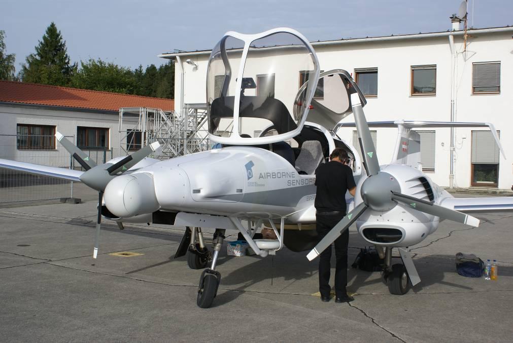
14 hardware: sat-nav component or, PolaNt survey antenna small patch antenna cable with TNC-connector to receiver Septentrio AsteRx1 GNSS (L1) receiver USB-cable to PC provides 5 V DC power to Rx & bi-direct. I/O with PC 14


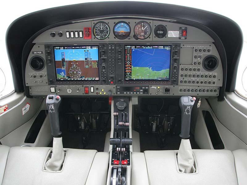
15 hardware 3DOF orientation tracker: 3D acceleration, 3D rate or turn (gyro) and 3D Earth magnetic field control deflections sensor (elevator and aileron displacement - optical) pilot-interface: 6.5 transreflective TFT 1024x768 pixels many different visualization possibilities/selections on-board computer (with database) 15
 from")

16 Lisbon - PT data acquisition ortho-photos terrain models (3D) from radar and lidar Bolzano - I resolution and accuracy dependent on distance to airport 16

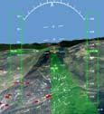
17 tunnel-in-the-sky: prediction tunnel generation: accounts for flight mechanics considerations and safety corridor; aircraft position is predicted ahead in time 17


18 integrated tunnel-in-the-sky real-time rendering and 3-D visualization LIBP Airport Bolzano Tunnel Center Line Ground Track 18
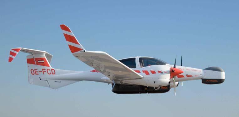
19 LANDING: flight-tests at Bolzano DA42 19

20 Flight test sat-nav component GPS antenna Cessna Citation II
 (through dual freq.")
21 Amsterdam Airport Schiphol Receiver autonomous integrity monitoring 52 North, 5 East at 1400 m altitude speed m/s 150 km accurate ground truth trajectory ( < 1 dm) (through dual freq. carrier DGPS to ref-stations) assess actual Position Error (PE) 4 hour flight 21
22 Position Error 22 flight test: 4 hours at 1 second interval accurate ground-truth trajectory established 95% HPE 1.05 m; 95% VPE 2.20 m
23 satellite navigation SBAS positioning (with EGNOS) delivers 1 m horizontal and 2 m vertical accuracy position quality guaranteed: integrity + reliability LANDING project 3-D guiding system for small aircraft to small airfields navigational aid and great situational awareness no ground-infrastructure required low cost h/w and s/w (COTS, ISO) easy to install and maintain working prototype pre-industrial phase 23

 http://www.lr.tudelft.nl/ 24 http://www.")
24 Faculty of Aerospace Engineering Delft University of Technology TU Delft Kluyverweg 1 NL-2629 HS DELFT (phone) (fax)
Aviation Benefits of GNSS Augmentation
 Aviation Benefits of GNSS Augmentation Workshop on the Applications of GNSS Chisinau, Moldova 17-21 May 2010 Jeffrey Auerbach Advisor on GNSS Affairs Office of Space and Advanced Technology U.S. Department
HORIZONTAL ARAIM AVAILABILITY FOR CIVIL AVIATION OPERATIONS. ARAIM Outreach event
 HORIZONTAL ARAIM AVAILABILITY FOR CIVIL AVIATION OPERATIONS ARAIM Outreach event Moses1978 copyright April 7, 2017 H-ARAIM availability for civil aviation operations 07/04/2017 1 INTRODUCTION Space Segment
Galileo & EGNOS Programmes Status
 Galileo & EGNOS Programmes Status Ugo Celestino, European Commission EURO-MEDITERRANEAN TRANSPORT FORUM GNSS WORKING GROUP 16 th October 2012 17 October, 2012 The European GNSS Programmes 2 Table of contents
ICAO policy on GNSS, GNSS SARPs and global GNSS developments. Jim Nagle Chief, Communication, Navigation and Surveillance Section ICAO
 ICAO policy on GNSS, GNSS SARPs and global GNSS developments Jim Nagle Chief, Communication, Navigation and Surveillance Section ICAO Presentation overview Introduction GNSS developments in ICAO ICAO policy
GBAS FOR ATCO. June 2017
 GBAS FOR ATCO June 2017 Disclaimer This presentation is for information purposes only. It should not be relied on as the sole source of information, and should always be used in the context of other authoritative
Indian GNSS Industry Overview Challenges and future prospects
 Indian GNSS Industry Overview Challenges and future prospects Expert Presentation By Dr. S.V. Kibe Consultant, SATCOM & GNSS, Bangalore, India (Former Programme Director, SATNAV,ISRO HQ) On February 20,2013
GNSS: CNS Dependencies
 GNSS: CNS Dependencies Lendina Smaja DATM/RDS/NAV 10 March 2015 Agenda The Future Technical Environment GNSS GNSS Supporting CNS Loss of Signal Impact GNSS: CNS Dependencies 2 Original FANS CNS/ATM Concept
GNSS-based Flight Inspection Systems
 GNSS-based Flight Inspection Systems Euiho Kim, Todd Walter, and J. David Powell Department of Aeronautics and Astronautics Stanford University Stanford, CA 94305, USA Abstract This paper presents novel
The Wide Area Augmentation System
 The Wide Area Augmentation System Stanford University http://waas.stanford.edu What is Augmentation? 2 Add to GNSS to Enhance Service Improve integrity via real time monitoring Improve availability and
SBAS solution GCC, Yemen and Iraq System baseline and performance
 SBAS solution GCC, Yemen and Iraq System baseline and performance ACAC Workshop Rabat 7 & 8 November 2017 1 2017 Thales Alenia Space PROPRIETARY C O M MINFORMATION E R C I A L I N THALES C O ALENIA N F
PORTABLE GNSS MONITORING STATION (PGMS)
") SPACE PORTABLE GNSS MONITORING STATION (PGMS) Satellite communications, earth observation, navigation and positioning and control stations indracompany.com PORTABLE GNSS MONITORING STATION (PGMS) PORTABLE
SPACE PORTABLE GNSS MONITORING STATION (PGMS) Satellite communications, earth observation, navigation and positioning and control stations indracompany.com PORTABLE GNSS MONITORING STATION (PGMS) PORTABLE
The experimental evaluation of the EGNOS safety-of-life services for railway signalling
 Computers in Railways XII 735 The experimental evaluation of the EGNOS safety-of-life services for railway signalling A. Filip, L. Bažant & H. Mocek Railway Infrastructure Administration, LIS, Pardubice,
SATELLITE BASED AUGMENTATION SYSTEM (SBAS) FOR AUSTRALIA
 FOR AUSTRALIA") SATELLITE BASED AUGMENTATION SYSTEM (SBAS) FOR AUSTRALIA AN AIN POSITION PAPER SUBMITTED TO VARIOUS GOVERNMENT DEPARTMENTS BY MR KYM OSLEY AM, CSC, EXEC SECRETARY AIN What are GNSS Augmentation Systems?
SATELLITE BASED AUGMENTATION SYSTEM (SBAS) FOR AUSTRALIA AN AIN POSITION PAPER SUBMITTED TO VARIOUS GOVERNMENT DEPARTMENTS BY MR KYM OSLEY AM, CSC, EXEC SECRETARY AIN What are GNSS Augmentation Systems?
Global Navigation Satellite System (GNSS) GPS Serves Over 400 Million Users Today. GPS is used throughout our society
 GPS Serves Over 400 Million Users Today. GPS is used throughout our society") Global avigation Satellite System (GSS) For freshmen at CKU AA December 10th, 2009 by Shau-Shiun Jan ICA & IAA, CKU Global avigation Satellite System (GSS) GSS (Global Positioning System, GPS) Basics Today
Global avigation Satellite System (GSS) For freshmen at CKU AA December 10th, 2009 by Shau-Shiun Jan ICA & IAA, CKU Global avigation Satellite System (GSS) GSS (Global Positioning System, GPS) Basics Today
Modern ARINC 743B DO-229D and DO-253C GLSSU Solutions For Retrofit
 Commercial Aviation Modern ARINC 743B DO-229D and DO-253C GLSSU Solutions For Retrofit Presented to AEEC March 2010 The Classic Retrofit Challenge Financial: Operating budget year financing ROI payback:
Status of the European EGNOS and Galileo Programmes. Frank Udnaes Galileo policy and Infrastructure group EC DG-TREN. June 2008
 Status of the European EGNOS and Galileo Programmes Frank Udnaes Galileo policy and Infrastructure group EC DG-TREN EUROPEAN COMMISSION z June 2008 Galileo An infrastructure 30 satellite Constellation
Satellite-Based Augmentation System (SBAS) Integrity Services
 Integrity Services") Satellite-Based Augmentation System (SBAS) Integrity Services Presented To: Munich, Germany Date: March 8, 2010 By: Leo Eldredge, Manager GNSS Group, FAA FAA Satellite Navigation Program 2 Wide Area Augmentation
Satellite-Based Augmentation System (SBAS) Integrity Services Presented To: Munich, Germany Date: March 8, 2010 By: Leo Eldredge, Manager GNSS Group, FAA FAA Satellite Navigation Program 2 Wide Area Augmentation
IMPLEMENTATION OF GNSS BASED SERVICES
 International Civil Aviation Organization IMPLEMENTATION OF GNSS BASED SERVICES Julio Siu Communications, Navigation and Surveillance Regional Officer ICAO NACC Regional Office ICAO Workshop on PBN Airspace
Status of ARAIM. S. Wallner ICG 6, Tokyo, Japan 05/09/2011. ESA UNCLASSIFIED For Official Use
 Status of ARAIM S. Wallner ICG 6, Tokyo, Japan 05/09/2011 ARAIM Concept Objectives Classical GPS RAIM for NPA used since years Evolving GNSS environment Multi-GNSS GPS/Galileo/Glonass/Compass/QZSS Dual-frequency
Aircraft Landing Systems Based on GPS & Galileo
 Aircraft Landing Systems Based on GPS & Galileo for the Czech Technical University by Per Enge Thursday 4 August, 2005 Future Aircraft Landing Systems: Outline 1. Today: Global Positioning System (GPS)
GNSS Programme. Overview and Status in Europe
 GNSS Programme Overview and Status in Europe Inaugural Forum Satellite Positioning Research and Application Center 23 April 2007 Tokyo Presented by Thomas Naecke (European Commission) Prepared by Daniel
European Geostationary Navigation Overlay Service (EGNOS) Capability on Sirius 5 Satellite for SES
 Capability on Sirius 5 Satellite for SES") 21 October 2009 SES SIRIUS European Geostationary Navigation Overlay Service (EGNOS) Capability on Sirius 5 Satellite for SES Mike Pavloff, Executive Director, Space Systems/Loral Information included
21 October 2009 SES SIRIUS European Geostationary Navigation Overlay Service (EGNOS) Capability on Sirius 5 Satellite for SES Mike Pavloff, Executive Director, Space Systems/Loral Information included
METIS Second Master Training & Seminar. Augmentation Systems Available in Egypt
 METIS Second Master Training & Seminar Augmentation Systems Available in Egypt By Eng. Ramadan Salem M. Sc. Surveying and Geodesy Email: ramadan_salem@link.net Page 1 Augmentation Systems Available in
Nigerian Communications Satellite Ltd. (NIGCOMSAT)
") OVERVIEW OF NIGERIAN SATELLITE AUGMENTATION SYSTEM COMMENCING WITH PILOT DEMONSTRATION TO VALIDATE NATIONAL WORK PLAN presented by Dr. Lawal Lasisi Salami, NIGERIAN COMMUNICATIONS SATELLITE LTD UNDER FEDERAL
OVERVIEW OF NIGERIAN SATELLITE AUGMENTATION SYSTEM COMMENCING WITH PILOT DEMONSTRATION TO VALIDATE NATIONAL WORK PLAN presented by Dr. Lawal Lasisi Salami, NIGERIAN COMMUNICATIONS SATELLITE LTD UNDER FEDERAL
Title: THE COMPARISON OF EGNOS PERFORMANCE AT THE AIRPORTS LOCATED IN EASTERN POLAND
 ACCEPTED MANUSCRIPT Title: THE COMPARISON OF EGNOS PERFORMANCE AT THE AIRPORTS LOCATED IN EASTERN POLAND Authors: Adam Ciećko, Grzegorz Grunwald To appear in: Technical Sciences Received 17 February 2016;
INTEGRITY AND CONTINUITY ANALYSIS FROM GPS JANUARY TO MARCH 2017 QUARTERLY REPORT
 INTEGRITY AND CONTINUITY ANALYSIS FROM GPS JANUARY TO MARCH 2017 QUARTERLY REPORT Name Responsibility Date Signature Prepared by M Pattinson (NSL) 11/04/17 Checked by L Banfield (NSL) 11/04/17 Authorised
Radio Navigation Aids Flight Test Seminar
 Radio Navigation Aids Flight Test Seminar FLIGHT INSPECTION IN THE NEW MILLENNIUM Curt Keedy FAA Flight Inspection Policy and Standards Change, Challenge, and Opportunity CHANGES Global Positioning system
FieldGenius Technical Notes GPS Terminology
 FieldGenius Technical Notes GPS Terminology Almanac A set of Keplerian orbital parameters which allow the satellite positions to be predicted into the future. Ambiguity An integer value of the number of
Distributed integrity monitoring of differential GPS corrections
 Distributed integrity monitoring of differential GPS corrections by Martin Pettersson Supervised by Fredrik Gustafsson Niclas Bergman Department of Automatic Control University of Linköpings Made for Luftfartsverket
Chapter 4 DGPS REQUIREMENTS AND EQUIPMENT SELECTION
 Chapter 4 DGPS REQUIREMENTS AND EQUIPMENT SELECTION 4.1 INTRODUCTION As discussed in the previous chapters, accurate determination of aircraft position is a strong requirement in several flight test applications
The Global Positioning System
 The Global Positioning System 5-1 US GPS Facts of Note DoD navigation system First launch on 22 Feb 1978, fully operational in 1994 ~$15 billion (?) invested to date 24 (+/-) Earth-orbiting satellites
Ground Based Augmentation Systems (GBAS) Introduction
 Introduction") Ground Based Augmentation Systems (GBAS) Introduction Technical and Operational Overview Andreas Lipp GBAS Implementation Workshop, ICAO EUR/NAT Paris, 18 March 2010 The European Organisation for the Safety
Ground Based Augmentation Systems (GBAS) Introduction Technical and Operational Overview Andreas Lipp GBAS Implementation Workshop, ICAO EUR/NAT Paris, 18 March 2010 The European Organisation for the Safety
INTEGRITY AND CONTINUITY ANALYSIS FROM GPS JULY TO SEPTEMBER 2016 QUARTERLY REPORT
 INTEGRITY AND CONTINUITY ANALYSIS FROM GPS JULY TO SEPTEMBER 2016 QUARTERLY REPORT Name Responsibility Date Signature Prepared by M Pattinson (NSL) 07/10/16 Checked by L Banfield (NSL) 07/10/16 Authorised
Prototyping Advanced RAIM for Vertical Guidance
 Prototyping Advanced RAIM for Vertical Guidance Juan Blanch, Myung Jun Choi, Todd Walter, Per Enge. Stanford University Kazushi Suzuki. NEC Corporation Abstract In the next decade, the GNSS environment
RESPONSE TO THE HOUSE OF COMMONS TRANSPORT SELECT COMMITTEE INQUIRY INTO GALILEO. Memorandum submitted by The Royal Academy of Engineering
 RESPONSE TO THE HOUSE OF COMMONS TRANSPORT SELECT COMMITTEE INQUIRY INTO GALILEO Memorandum submitted by The Royal Academy of Engineering September 2004 Executive Summary The Royal Academy of Engineering
An Introduction to Airline Communication Types
 AN INTEL COMPANY An Introduction to Airline Communication Types By Chip Downing, Senior Director, Aerospace & Defense WHEN IT MATTERS, IT RUNS ON WIND RIVER EXECUTIVE SUMMARY Today s global airliners use
GPS Milestones, cont. GPS Milestones. The Global Positioning Sytem, Part 1 10/10/2017. M. Helper, GEO 327G/386G, UT Austin 1. US GPS Facts of Note
 The Global Positioning System US GPS Facts of Note DoD navigation system First launch on 22 Feb 1978, fully operational in 1994 ~$15 billion (?) invested to date 24 (+/-) Earth-orbiting satellites (SVs)
GPS: The Basics. Darrell R. Dean, Jr. Civil and Environmental Engineering West Virginia University. Expected Learning Outcomes for GPS
 GPS: The Basics Darrell R. Dean, Jr. Civil and Environmental Engineering West Virginia University Expected Learning Outcomes for GPS Explain the acronym GPS Name 3 important tdt dates in history of GPS
Introduction to GNSS Base-Station
 Introduction to GNSS Base-Station Dinesh Manandhar Center for Spatial Information Science The University of Tokyo Contact Information: dinesh@iis.u-tokyo.ac.jp Slide : 1 Introduction GPS or GNSS observation
GAGAN Initiatives Jan 18, 2018
 GAGAN Initiatives Jan 18, 2018 Topics covered 1. Brief profile of GAGAN 2. Features / Accuracy of GAGAN System 3. GAGAN Architecture 4. GAGAN services and Coverage 5. GAGAN utilization in aviation sector
ESTIMATION OF IONOSPHERIC DELAY FOR SINGLE AND DUAL FREQUENCY GPS RECEIVERS: A COMPARISON
 ESTMATON OF ONOSPHERC DELAY FOR SNGLE AND DUAL FREQUENCY GPS RECEVERS: A COMPARSON K. Durga Rao, Dr. V B S Srilatha ndira Dutt Dept. of ECE, GTAM UNVERSTY Abstract: Global Positioning System is the emerging
Demonstrations of Multi-Constellation Advanced RAIM for Vertical Guidance using GPS and GLONASS Signals
 Demonstrations of Multi-Constellation Advanced RAIM for Vertical Guidance using GPS and GLONASS Signals Myungjun Choi, Juan Blanch, Stanford University Dennis Akos, University of Colorado Boulder Liang
GNSS Signal Structures
 GNSS Signal Structures Tom Stansell Stansell Consulting Tom@Stansell.com Bangkok, Thailand 23 January 2018 S t a n s e l l C o n s u l t i n g RL Introduction It s a pleasure to speak with you this morning.
GPS/WAAS Program Update
 GPS/WAAS Program Update UN/Argentina Workshop on the Applications of GNSS 19-23 March 2018 Cordoba, Argentina GNSS: A Global Navigation Satellite System of Systems Global Constellations GPS (24+3) GLONASS
Satellite navigation applications: opportunities from the European GNSS. Fiammetta Diani Deputy Head of Market Development European GNSS Agency
 Satellite navigation applications: opportunities from the European GNSS Fiammetta Diani Deputy Head of Market Development European GNSS Agency FP7 success story in Lithuania COSUDEC Coastal Surveying of
Galileo - European Global Navigation Satellite System
 Abstract Galileo - European Global Navigation Satellite System Wu Chen Department of Land Surveying and Geoinformatics Hong Kong Polytechnic University e-mail: Lswuchen@polyu.du.hk Washington Yotto Ochieng
High Precision GNSS in Automotive
 High Precision GNSS in Automotive Jonathan Auld, VP Engineering and Safety 6, March, 2018 2 Global OEM Positioning Solutions and Services for Land, Sea, and Air. GNSS in Automotive Today Today the primary
GALILEO Workshop, 26.Sep Marco FALCONE GALILEO System Engineering Manager GALILEO Project Office Tel
 GALILEO Workshop, 26.Sep.2005 European Space Agency A g ence spatiale européenne ESTEC Postbus 299 - NL2200 AG Noordwijk - Keplerlaan - NL 2201 AZ Noordwijk ZH - Tel. (31) 71 5656565 - Fax (31) 71 5656040
ARAIM Fault Detection and Exclusion
 ARAIM Fault Detection and Exclusion Boris Pervan Illinois Institute of Technology Chicago, IL November 16, 2017 1 RAIM ARAIM Receiver Autonomous Integrity Monitoring (RAIM) uses redundant GNSS measurements
Global Navigation Satellite Systems (GNSS)
") Global Navigation Satellite Systems (GNSS) Pat Norris MRAeS, FRIN LogicaCMG Business Development Manager Chairman, RAeS Space Group LogicaCMG 2006. All rights reserved 2 Global Navigation Satellite Systems
Global Navigation Satellite Systems (GNSS) Pat Norris MRAeS, FRIN LogicaCMG Business Development Manager Chairman, RAeS Space Group LogicaCMG 2006. All rights reserved 2 Global Navigation Satellite Systems
On Location at Stanford University
 Thank you for inviting me to Calgary On Location at Stanford University by Per Enge (with the help of many) May 29, 2009 With Gratitude to the Federal Aviation Administration from Misra and Enge, 2006
EGNOS status and performance in the context of marine navigation requirements
 EGNOS status and performance in the context of marine navigation requirements J. Cydejko Gdynia Maritime University, Gdynia, Poland ABSTRACT: The current status of EGNOS (December 2006) is described as
Understanding GPS: Principles and Applications Second Edition
 Understanding GPS: Principles and Applications Second Edition Elliott Kaplan and Christopher Hegarty ISBN 1-58053-894-0 Approx. 680 pages Navtech Part #1024 This thoroughly updated second edition of an
CONSIDERATIONS FOR GNSS MEASUREMENTS
 CONSIDERATIONS FOR GNSS MEASUREMENTS Cornel PĂUNESCU 1, Cristian VASILE 2, Cosmin CIUCULESCU 3 1 PhD University of Bucharest, e-mail: cornelpaun@gmail.com 2 Lecturer PhD University of Craiova, cristi_vasile_4you@yahoo.com
Ionospheric Corrections for GNSS
 Ionospheric Corrections for GNSS The Atmosphere and its Effect on GNSS Systems 14 to 16 April 2008 Santiago, Chile Ing. Roland Lejeune Overview Ionospheric delay corrections Core constellations GPS GALILEO
NR402 GIS Applications in Natural Resources
 NR402 GIS Applications in Natural Resources Lesson 5 GPS/GIS integration Global Positioning System (GPS)..a global navigation system that everyone can use What is GPS? How does it work? How accurate is
GBAS CAT II/III concepts for flexible approach procedures
 GBAS CAT II/III concepts for flexible approach procedures Thomas Feuerle, Mark Bitter, Peter Hecker (TU Braunschweig) Robert Geister (DLR) 2 nd ENRI Workshop on ATM/CNS, Tokyo Content Motivation & preparationary
GPS with RAIM or EGNOS? The difference for (mountainous) helicopter operations. Marc Troller Skyguide / CNS expert group
 helicopter operations. Marc Troller Skyguide / CNS expert group") GPS with RAIM or EGNOS? The difference for (mountainous) helicopter operations Marc Troller Skyguide / CNS expert group 1 Motivation for Dedicated Helicopter Procedures Swiss GNSS LFN network: Mandate
GPS with RAIM or EGNOS? The difference for (mountainous) helicopter operations Marc Troller Skyguide / CNS expert group 1 Motivation for Dedicated Helicopter Procedures Swiss GNSS LFN network: Mandate
Bring satellites into your lab: GNSS simulators from the T&M expert.
 Bring satellites into your lab: GNSS simulators from the T&M expert. www.rohde-schwarz.com/gnss-solutions Your challenge GNSS receiver tests can only be conclusive when they are performed under realistic
Galileo. 7th ITFS, Rome, Italy, 3-5 November Dr. Stefan Bedrich. Kayser-Threde GmbH Wolfratshauser Str Munich
 Kayser-Threde GmbH Wolfratshauser Str. 48 81379 Munich spacetech@kayser-threde.com Galileo 7th ITFS, Rome, Italy, 3-5 November 2009 Dr. Stefan Bedrich w w w. k a y s e r - t h r e d e. c o m Outline Motivation
Civil Applications of Galileo. Brussels, June 12, 2006 Ir. Peter A. Grognard Founder and CEO, Septentrio nv
 Civil Applications of Galileo Brussels, June 12, 2006 Ir. Peter A. Grognard Founder and CEO, Septentrio nv Company overview Founded January 21, 2000 in Leuven, Belgium Spin-off of Interuniversity MicroElectronics
Lecture-1 CHAPTER 2 INTRODUCTION TO GPS
 Lecture-1 CHAPTER 2 INTRODUCTION TO GPS 2.1 History of GPS GPS is a global navigation satellite system (GNSS). It is the commonly used acronym of NAVSTAR (NAVigation System with Time And Ranging) GPS (Global
The Mid-term Review of the European Satellite Radio Navigation Programmes Galileo and EGNOS: Questions and Answers
 MEMO/11/26 Brussels, 18 th January 2011 The Mid-term Review of the European Satellite Radio Navigation Programmes Galileo and EGNOS: Questions and Answers See also IP/11/42 For the full text of the Communication
Special Committee SC-159 Navigation Equipment Using the Global Navigation Satellite System (GNSS) (Version 11)
 (Version 11)") RTCA Paper No. 094-18/PMC-1737 March 22, 2018 TERMS OF REFERENCE Special Committee SC-159 Navigation Equipment Using the Global Navigation Satellite System (GNSS) (Version 11) REQUESTOR: Organization Person
RTCA Paper No. 094-18/PMC-1737 March 22, 2018 TERMS OF REFERENCE Special Committee SC-159 Navigation Equipment Using the Global Navigation Satellite System (GNSS) (Version 11) REQUESTOR: Organization Person
REPORT OF COMMITTEE B TO THE CONFERENCE ON AGENDA ITEM 6
 1/10/03 ELEVENTH AIR NAVIGATION CONFERENCE Montreal, 22 September to 3 October 2003 REPORT OF COMMITTEE B TO THE CONFERENCE ON AGENDA ITEM 6 The attached report has been approved by Committee B for submission
APPENDIX C VISUAL AND NAVIGATIONAL AIDS
 VISUAL AND NAVIGATIONAL AIDS APPENDIX C VISUAL AND NAVIGATIONAL AIDS An integral part of the airport system is the visual and navigational aids provided to assist pilots in navigating both on the airfield
Arctic Navigation Issues. e-nav conference Nordic Institute of Navigation Bergen, March 5 th 2009
 Arctic Navigation Issues e-nav conference Nordic Institute of Navigation Bergen, March 5 th 2009 by Anna B.O. Jensen - AJ Geomatics Jean-Paul Sicard - Rovsing A/S March 2009 1 Outline Reduction of ice
Challenges and Solutions for GPS Receiver Test
 Challenges and Solutions for GPS Receiver Test Presenter: Mirin Lew January 28, 2010 Agenda GPS technology concepts GPS and GNSS overview Assisted GPS (A-GPS) Basic tests required for GPS receiver verification
Galileo Information Center for Latin America / Application of the ISMR Query Tool in the analysis of Ionospheric Scintillation from Galileo Satellites
 Galileo Information Center for Latin America / Application of the ISMR Query Tool in the analysis of Ionospheric Scintillation from Galileo Satellites Bruno César Vani Programa de Pós-graduação em Ciências
ELEVENTH AIR NAVIGATION CONFERENCE. Montreal, 22 September to 3 October 2003 TOOLS AND FUNCTIONS FOR GNSS RAIM/FDE AVAILABILITY DETERMINATION
 19/9/03 ELEVENTH AIR NAVIGATION CONFERENCE Montreal, 22 September to 3 October 2003 Agenda Item 6 : Aeronautical navigation issues TOOLS AND FUNCTIONS FOR GNSS RAIM/FDE AVAILABILITY DETERMINATION (Presented
GSS8000. Highlights of the GSS8000 series. Multiple Signals Combined. Comprehensive Modelling. Unmatched Pedigree and Support
 GSS8000 SERIES GSS8000 Highlights of the GSS8000 series The GSS8000 series has been designed to meet all the demanding requirements of research and development teams involved in satellite navigation and
The EU Satellite Navigation programmes status Applications for the CAP
 The EU Satellite Navigation programmes status Applications for the CAP Michaël MASTIER European Commission DG ENTR GP3 GNSS Applications, Security and International aspects GPS Workshop 2010 Montpellier
ICG 9 PRAGUE 10 November 2014
 ICG 9 PRAGUE 10 November 2014 GNSS and applications GNSS is technology powerfully enabler of a multitude of applications. Italy, recognizing that, have undertaken initiatives to develop pre-operational
Final Project Report. Abstract. Document information
 Final Project Report Document information Project Title Multi-constellation GNSS Airborne Navigation Systems Project Number 09.27 Project Manager Thales Avionics Deliverable Name Final Project Report Deliverable
Special Committee SC-159 Navigation Equipment Using the Global Navigation Satellite System (GNSS) (Version 13)
 (Version 13)") RTCA Paper No. 307-18/PMC-1839 December 13, 2018 TERMS OF REFERENCE Special Committee SC-159 Navigation Equipment Using the Global Navigation Satellite System (GNSS) (Version 13) REQUESTOR: Organization
RTCA Paper No. 307-18/PMC-1839 December 13, 2018 TERMS OF REFERENCE Special Committee SC-159 Navigation Equipment Using the Global Navigation Satellite System (GNSS) (Version 13) REQUESTOR: Organization
RESULTS OF THE REGIONAL SBAS TEST BED TYPE WAAS PROYECT RLA/00/009. Onofrio Smarrelli ICAO SAM CNS Lima Regional Office
 WORKSHOP / SEMINAR FOR THE IMPLEMENTATION OF NAVIGATION INFRASTRUCTURE TO SUPPORT PBN AND GNSS PRECISION APPROACH OPERATIONS IN THE NAM CAR SAM REGION (Lima, Peru 15 to 17 August 2016 ) RESULTS OF THE
Latest Evolution of RAIM Prediction Systems
 Latest Evolution of RAIM Prediction Systems SPACEKEYS is a project funded by the European Space Agency SPACEKEYS 2018. All rights reserved. Topics Rationale Requirements Objectives Results Achievements
GNSS MONITORING NETWORKS
 SPACE GNSS MONITORING NETWORKS Satellite communications, earth observation, navigation and positioning and control stations indracompany.com GNSS MONITORING NETWORKS GNSS MONITORING NETWORKS Indra s solutions
Wide Area Augmentation System (WAAS)
") Wide Area Augmentation System (WAAS) Ionospheric Effects Symposium By: Jason Burns Technology Evolution Lead Date: Agenda WAAS Overview Ionospheric Effects on WAAS Future Plans User Segment Update 2 WAAS
Wide Area Augmentation System (WAAS) Ionospheric Effects Symposium By: Jason Burns Technology Evolution Lead Date: Agenda WAAS Overview Ionospheric Effects on WAAS Future Plans User Segment Update 2 WAAS
Positioning, location data and GNSS as solution for Autonomous driving
 Positioning, location data and GNSS as solution for Autonomous driving Jarkko Koskinen, Heidi Kuusniemi, Juha Hyyppä, Sarang Thombre and Martti Kirkko-Jaakkola FGI, NLS Definition of the Arctic 66 34 N
The Galileo and EGNOS Programmes
 The Galileo and EGNOS Programmes Dominic Hayes European Commission ignss, Gold Coast, 14 July 2015 The European GNSS Programmes 2 Organisation and Contractual Frameworks European Union Member States (28)
Precise Positioning... what does it mean? Precise GNSS Positioning Not just a niche technology. Chris Rizos 15/12/15
 Precise GNSS Positioning Not just a niche technology Chris Rizos Precise Positioning... what does it mean? 1 Precise Positioning... a spectrum of users... Few mm 1cm 2cm < dm 1dm sub-m Precision agriculture
ORBITAL NAVIGATION SYSTEMS PRESENT AND FUTURE TENDS
 ORBITAL NAVIGATION SYSTEMS PRESENT AND FUTURE TENDS CONTENT WHAT IS COVERED A BRIEF HISTORY OF SYSTEMS PRESENT SYSTEMS IN USE PROBLEMS WITH SATELLITE SYSTEMS PLANNED IMPROVEMENTS CONCLUSION CONTENT WHAT
The European Satellite Radio Navigation Programmes Galileo and EGNOS: Questions and Answers
 MEMO/11/326 Brussels, 23 May 2011 The European Satellite Radio Navigation Programmes Galileo and EGNOS: Questions and Answers What is satellite navigation? Satellite navigation is based on the principle
PBN fleet equipage according to FPL content. Michel ROELANDT
 PBN fleet equipage according to FPL content Michel ROELANDT EUROCONTROL RAiSG/PBN TF Meeting March 2014 Introduction 15 Nov 2012: standard ICAO format for airline flight plans changed. New fields have
GalileoSat System Simulation Facility (GSSF)
") GalileoSat System Simulation Facility (GSSF) VEGA Informations-Technologien GmbH Slide 1 Introduction GSSF Project Overview GSSF Requirements The GSSF System ❽ Components ❽ User Interface ❽ Technology
GalileoSat System Simulation Facility (GSSF) VEGA Informations-Technologien GmbH Slide 1 Introduction GSSF Project Overview GSSF Requirements The GSSF System ❽ Components ❽ User Interface ❽ Technology
Introduction to GNSS opportunities in different Market Segments. Fiammetta Diani Market Development
 Introduction to GNSS opportunities in different Market Segments Fiammetta Diani Market Development fiammetta.diani@gsa.europa.eu 3-Mar-14 European GNSS Agency 2 Congratulations! Agenda European GNSS market
RAIM Availability prediction
 RAIM Availability prediction Main content 一 Background & research purposes 二 Related research in China and abroad 三 Theory and arithmetic 四 RAIM systems development 五 The vision of the future 1 Background
[EN-A-008] GBAS Interoperability and Multi-Constellation / Multi-Frequency Trials
![[EN-A-008] GBAS Interoperability and Multi-Constellation / Multi-Frequency Trials](/thumbs/80/80771251.jpg "[EN-A-008] GBAS Interoperability and Multi-Constellation / Multi-Frequency Trials") ENRI Int. Workshop on ATM/CNS. Tokyo, Japan. (EIWAC 17) [EN-A-8] GBAS Interoperability and Multi-Constellation / Multi-Frequency Trials (EIWAC 17) + T. Feuerle *, M. Stanisak *, S. Saito, T. Yoshihara,
ENRI Int. Workshop on ATM/CNS. Tokyo, Japan. (EIWAC 17) [EN-A-8] GBAS Interoperability and Multi-Constellation / Multi-Frequency Trials (EIWAC 17) + T. Feuerle *, M. Stanisak *, S. Saito, T. Yoshihara,
SBAS DFMC performance analysis with the SBAS DFMC Service Volume software Prototype (DSVP)
") SBAS DFMC performance analysis with the SBAS DFMC Service Volume software Prototype (DSVP) D. Salos, M. Mabilleau, Egis Avia C. Rodriguez, H. Secretan, N. Suard, CNES (French Space Agency) Email: Daniel.salos@egis.fr
SBAS DFMC performance analysis with the SBAS DFMC Service Volume software Prototype (DSVP) D. Salos, M. Mabilleau, Egis Avia C. Rodriguez, H. Secretan, N. Suard, CNES (French Space Agency) Email: Daniel.salos@egis.fr
GA and NextGen How technologies like WAAS and ADS-B will change your flying! Presented By Claire Kultgen
 GA and NextGen How technologies like WAAS and ADS-B will change your flying! Presented By Claire Kultgen Overview 1. TIS 2. ADS-B FIS-B TIS-B ADS-R 3. WAAS 4. T-Routes and GPS MEAs Questions Chat Pilot
GNSS for Landing Systems and Carrier Smoothing Techniques Christoph Günther, Patrick Henkel
 GNSS for Landing Systems and Carrier Smoothing Techniques Christoph Günther, Patrick Henkel Institute of Communications and Navigation Page 1 Instrument Landing System workhorse for all CAT-I III approach
Integration of GPS with a Rubidium Clock and a Barometer for Land Vehicle Navigation
 Integration of GPS with a Rubidium Clock and a Barometer for Land Vehicle Navigation Zhaonian Zhang, Department of Geomatics Engineering, The University of Calgary BIOGRAPHY Zhaonian Zhang is a MSc student
Introduction to the Global Positioning System
 GPS for Fire Management - 2004 Introduction to the Global Positioning System Pre-Work Pre-Work Objectives Describe at least three sources of GPS signal error, and identify ways to mitigate or reduce those
Annex 10 Aeronautical Communications
 Attachment D 3.2.8.1 For Basic GNSS receivers, the receiver qualification standards require demonstration of user positioning accuracy in the presence of interference and a model of selective availability
Prepared by Dr. Javier Ventura-Traveset
 Prepared by Dr. Javier Ventura-Traveset EGNOS Project Office. Toulouse (France). European Space Agency. EGNOS Receiver Manufacturers Workshop, Paris, ESA HQ, July 3, 2003 Page 1 EUROPEAN GNSS STRATEGY
GNSS Solutions: Do GNSS augmentation systems certified for aviation use,
 GNSS Solutions: WAAS Functions and Differential Biases GNSS Solutions is a regular column featuring questions and answers about technical aspects of GNSS. Readers are invited to send their questions to
ARAIM: Utilization of Modernized GNSS for Aircraft-Based Navigation Integrity
 ARAIM: Utilization of Modernized GNSS for Aircraft-Based Navigation Integrity Alexandru (Ene) Spletter Deutsches Zentrum für Luft- und Raumfahrt (DLR), e.v. The author gratefully acknowledges the support
Horizontal Advanced RAIM: Operational Benefits and Future Challenges
 Horizontal Advanced RAIM: Operational Benefits and Future Challenges International Technical Symposium on Navigation and Timing 2015 Session Air Navigation November 2015 Toulouse/France 1 ICAO ABAS augmentation
Where Next for GNSS?
 Where Next for GNSS? Professor Terry Moore Professor of Satellite Navigation Nottingham The University of Nottingham Where Next for GNSS Back to the Future? Professor Terry Moore Professor of Satellite