Aircraft Landing Systems Based on GPS & Galileo
|
|
|
- Tamsin Byrd
- 6 years ago
- Views:
Transcription

1 Aircraft Landing Systems Based on GPS & Galileo for the Czech Technical University by Per Enge Thursday 4 August, 2005
2 Future Aircraft Landing Systems: Outline 1. Today: Global Positioning System (GPS) & Augmentations 2. Tomorrow: Modernized GPS & Galileo New signals Category I from SBAS & Galileo 3. Continued Need for the Local Element Category II/III Unexploded ordinance 4. Continuity Will be Key! Antennas Inertial Navigation
3 Global Positioning System Space Segment Uplink Ephemeris & Clock Data Broadcast of Navigation data Spread-spectrum ranging signals Control Segment 60,000,000 users?? Five Monitor Stations & Four Upload Stations Spread Around the Equator


4 GPS Receiver Bazaar by Frank Van Diggelen, GlobalLocate Survey & Mapping Original civil application Tripod mounted Exclusively Differential GPS One meter to centimeter accuracy $2500-$40,000 Chip sets/single chip GPS $5-$20 Lowest prices from sharing the host CPU


5 Receiver Bazaar (cont d) Handheld receivers For hikers, geo-cachers & sailors. Small in size with simple maps. Ruggedized for outdoor/marine use. $70-$500 GPS cell-phones with GPS embedded. In 2004, 50% of GPS receivers are in cell phones. Mostly for emergency calls only. LBS applications are emerging. $200-$500


6 Receiver Bazaar (cont d) GPS smart-phones (cell phone + PDA) GPS is embedded. GPS used for emergency calls Applications include: basic maps spoken turn-by-turn directions $400-$800 Dedicated in-car navigation systems. Detailed street maps Spoken turn-by-turn directions $400-$2000


7 Receiver Bazaar (cont d) OEM boards Enables custom integration $30-$100 Marine navigation Large screens Electronic charts Sophisticated nav. functions Large marine data bases. $400-$3000
8 GPS constellation Differential GPS Data broadcast of corrections Reference receiver(s) compare measured pseudoranges to theoranges. Roving receivers apply corrections to measured pseudoranges

9 Differential GPS Radiobeacons Around the World Ref: CSI, Inc.
10 Space Based Augmentation System (SBAS) Wide Area Augmentation System (WAAS) in the U.S. GPS constellation Geostationary broadcast of 1.) Continental corrections 2.) Data for error bounds 3.) Ranging signal Uplink station Reference receivers Central processor

11 SBAS Reference Stations in the U.S.


12 Aviation Receivers Air Transport multi-mode receiver GBAS/ILS/MLS General aviation panel mounted with maps SBAS/VOR/DME VHF voice

13 SBAS Enables Precision Approach Down to 300 Feet APV DH=350 DH VAL=50 m DH: decision height VAL:vertical alert limit LAL: horizontal alert limit APV: approach with vertical guidance

14
15 Typical WAAS Vertical Error and VPL
16
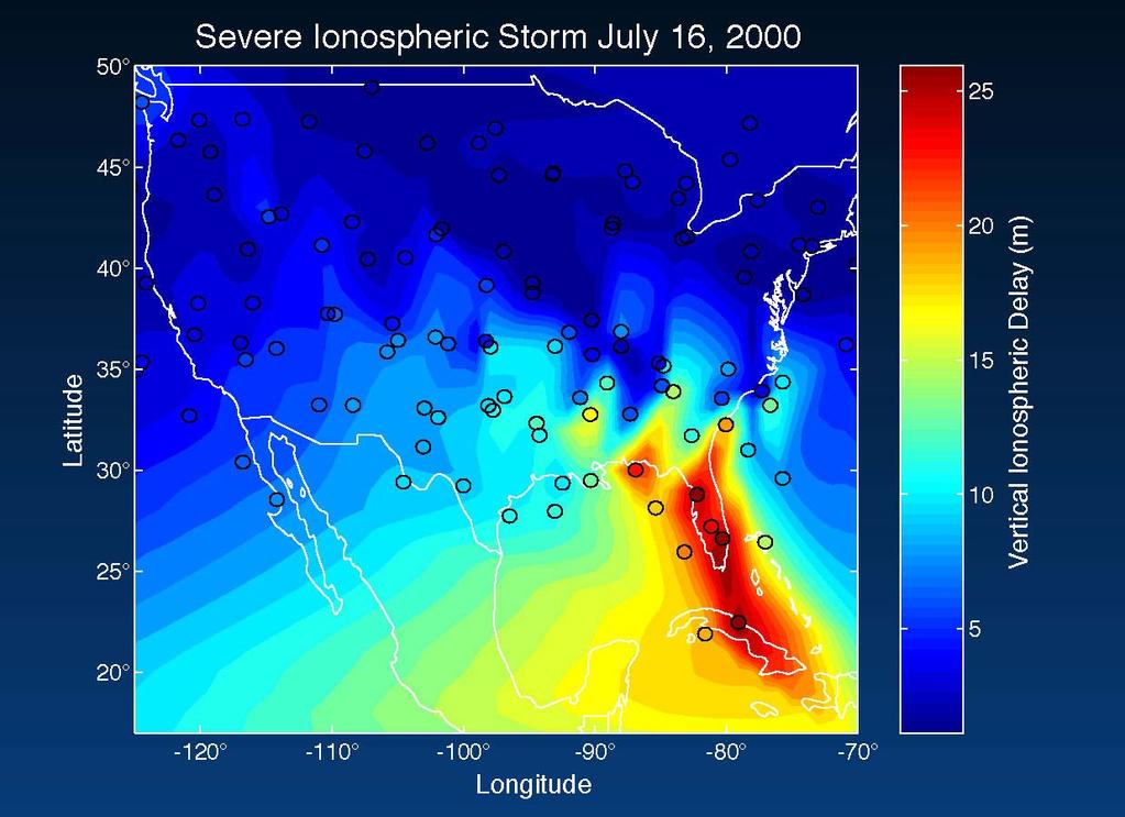
17 WAAS Vertical Error & VPL on a Storm Day
18 Future Aircraft Landing Systems: Outline 1. Today: Global Positioning System (GPS) & Augmentations 2. Tomorrow: Modernized GPS & Galileo New signals Category I from SBAS & Galileo 3. Continued Need for the Local Element Category II/III Unexploded ordinance 4. Continuity Will be Key! Antennas Inertial Navigation
19 GPS Signals: Present and Future Today s satellites Military C A Military New satellites launched beginning in 2005 RC Military C A Military New satellites launched near the end of the decade L RC Military C A Military
20 Galileo E5/A GNSS Spectrum Galileo E5/B GPS L2 Glonass G2 Galileo E6 GPS L1 Glonass G2 1151MHz 1164MHz 1188MHz 1214MHz 1215MHz 1237MHz 1239MHz 1254MHz 1258MHz 1260MHz 1261MHz 1300MHz 1559MHz 1563MHz 1587MHz 1591MHz 1593MHz 1610MHz 5010MHz 5030MHz 5250MHz ARNS RNSS ARNS ARNS RNSS* RNSS* RNSS RNSS Galileo C1 960MHz Galileo E3 GPS L5 Lower L-Band Upper L-Band C-Band Galileo E4 Galileo E2 Galileo E1 RNSS* shared with other services Galileo E5/A or E5/B frequency band options
21 SBAS With Dual Frequency GPS & Galileo Will Enable Precision Approach Down to 200 Feet APV DH=350 DH VAL=50 m CAT I DH=200 ft VAL=10 m DH: decision height VAL:vertical alert limit LAL: horizontal alert limit APV: approach with vertical guidance
22 Future Aircraft Landing Systems: Outline 1. Today: Global Positioning System (GPS) & Augmentations 2. Tomorrow: Modernized GPS & Galileo New signals Category I from SBAS & Galileo 3. Continued Need for the Local Element Category II/III Unexploded ordinance 4. Continuity Will be Key! Antennas Inertial Navigation
23 Precision Approach APV DH=350 DH VAL=50 m CAT I DH=200 ft VAL=10 m Local element required: Ground Based Augmentation System Local Area Augmentation System CAT II DH=100 ft VAL=5.3 m CAT III DH=0-100 ft VAL=5.3 m DH: decision height VAL:vertical alert limit LAL: horizontal alert limit APV: approach with vertical guidance
24 Ground Based Augmentation System (GBAS) GPS constellation VHF data broadcast of airport corrections data for error bounding Airport Property Multiple GPS receivers used for cross-checking & redundancy Central processor to generate corrections & error bounding data

25 Other Applications for the Local Element Disarm Unexploded Ordinance (UXO) In the U.S. alone, UXO is spread over 10 million acres at 1400 sites. Current DoD budget is $200M/year.

26 Search for Unexploded Ordinance at Camp Bonneville Centimeter accuracy under foliage requires the integration of DGPS & aiding technology
27 Future Aircraft Landing Systems: Outline 1. Today: Global Positioning System (GPS) & Augmentations 2. Tomorrow: Modernized GPS & Galileo New signals Category I from SBAS & Galileo 3. Continued Need for the Local Element Category II/III Unexploded ordinance 4. Continuity Will be Key! Antennas Inertial Navigation

28 Prototype of Dual Radiation Pattern Antenna (from Frank Bauregger)
29 Theoretical Radiation Patterns Wide-looking Patch Narrow-looking Patch - Roll Pattern for Antenna Mounted on Cessna Caravan
30 Flight Results for DRPA (from Bauregger)
31 Multi-Element Antennas source beam Reject RFI & multipath Achieve sub-meter accuracy Limit biases in carrier phase and code phase null RFI 1 weight & shift
32 Inertial Measurements to Aid GPS Tracking (Jennifer Gautier) IMU 3 gyros 3 accels θ, v Navigation Processor P,V, A,T Kalman Filter GPS Receiver Measurement Processor ρ,ρdot Navigation Processor P,V,T Deeply Loosely Tightly Integrated Coupled System or Ultra Tightly Coupled System
33 INS/GPS Hybrid for LAAS CAT III RFI Final Approach Fix Ground Facility with VHF Data Broadcast Final Approach Segment: 9 km INS navigation w/ or w/o GPS Intermediate Approach Segment: Inertial Calibration with CDGPS
34 One Dimensional Error Growth for Tactical and Automotive Inertial Navigation Systems D Pos. Error For White & Gauss-Markov Noise Only Auto. Acc & GyroØ Position E rro rhml rate-aid PLL Auto. Acc OnlyØ from FAF Tactical Acc & Gyro Tactical Acc Only fly across terminal area Time HsL
35 Stanford Center for Navigation & Time Navigation & time technology will benefit billions of people, millions of businesses, & most nations in a life altering manner in the next 20 years much as is the Internet Although the design of GPS in 1973 began this technology revolution, this technology is just in its infancy. Stanford University Departments in AA, EE, ME, and Physics are each contributing exciting, novel new technologies, and together can play a leading role in this technology revolution which necessarily crosses many department boundaries

36 Atom-based Inertial Sensors to Deliver 5 m/hour (from Mark Kasevich) Laser cooled atoms are sensor proof masses. Atoms are in a near perfect inertial frame of reference. Pulses of laser light measure relative motion between atoms and case. Sensor accuracy derives from the use of optical wavefronts to determine this relative motion. Field-ready cold atom accelerometer. Demonstrated 10-9 g bias stability
 100 mdeg/hr 1/2 ARW 10-7 g/hz 1/2 accel noise 100 Hz")
37 Atom Sensors Technology Vision for Full IMU (from Mark Kasevich) 50 m/hour 3 cm x 3 cm x 1 cm Low-power (10 mw) 100 mdeg/hr 1/2 ARW 10-7 g/hz 1/2 accel noise 100 Hz bandwidth

 Goal --2 orders of magnitude")
38 Build MEMS resonator and encapsulation at same time. Use only CMOS compatible process steps. Resulting resonators are stable, inexpensive, small Wafer Scale Silicon Oscillators (from Tom Kenney) Goal --2 orders of magnitude stability improvement over quartz oscillators
39 Summary: Vector Delay Lock Loop (from Jim Spilker) satellite navigation signals Generalized Vector Delay Lock Tracking Navigation System `` ` ` Cordinate translator Kalman Filter ` ` ` ` beam steering antenna clock IMU parallel correlator bank chip scale atomic clock generalized Kalman filter atomic inertial measurement units Integration of RF satellite, inertial, and clock sensors into one quasi-optimal Navigation, Attitude, Time estimator
Global Navigation Satellite System (GNSS) GPS Serves Over 400 Million Users Today. GPS is used throughout our society
 GPS Serves Over 400 Million Users Today. GPS is used throughout our society") Global avigation Satellite System (GSS) For freshmen at CKU AA December 10th, 2009 by Shau-Shiun Jan ICA & IAA, CKU Global avigation Satellite System (GSS) GSS (Global Positioning System, GPS) Basics Today
Global avigation Satellite System (GSS) For freshmen at CKU AA December 10th, 2009 by Shau-Shiun Jan ICA & IAA, CKU Global avigation Satellite System (GSS) GSS (Global Positioning System, GPS) Basics Today
On Location at Stanford University
 Thank you for inviting me to Calgary On Location at Stanford University by Per Enge (with the help of many) May 29, 2009 With Gratitude to the Federal Aviation Administration from Misra and Enge, 2006
On Location at Stanford University
 Thank you for inviting me (back) to Deutsches Zentrum für Luft- und Raumfahrt On Location at Stanford University by Per Enge (with the help of many) July 27, 2009 My thanks to the Federal Aviation Administration
On Location at Stanford University
 Thank you for inviting me (back) to Southern California On Location at Stanford University by Per Enge (with the help of many) June 30, 2009 My thanks to the Federal Aviation Administration Outline Landing
GPS-Aided INS Datasheet Rev. 2.6
 GPS-Aided INS 1 GPS-Aided INS The Inertial Labs Single and Dual Antenna GPS-Aided Inertial Navigation System INS is new generation of fully-integrated, combined GPS, GLONASS, GALILEO and BEIDOU navigation
Inertial Sensors. Ellipse 2 Series MINIATURE HIGH PERFORMANCE. Navigation, Motion & Heave Sensing IMU AHRS MRU INS VG
 Ellipse 2 Series MINIATURE HIGH PERFORMANCE Inertial Sensors IMU AHRS MRU INS VG ITAR Free 0.1 RMS Navigation, Motion & Heave Sensing ELLIPSE SERIES sets up new standard for miniature and cost-effective
Radio Navigation Aids Flight Test Seminar
 Radio Navigation Aids Flight Test Seminar FLIGHT INSPECTION IN THE NEW MILLENNIUM Curt Keedy FAA Flight Inspection Policy and Standards Change, Challenge, and Opportunity CHANGES Global Positioning system
GPS-Aided INS Datasheet Rev. 2.3
 GPS-Aided INS 1 The Inertial Labs Single and Dual Antenna GPS-Aided Inertial Navigation System INS is new generation of fully-integrated, combined L1 & L2 GPS, GLONASS, GALILEO and BEIDOU navigation and
Understanding GPS: Principles and Applications Second Edition
 Understanding GPS: Principles and Applications Second Edition Elliott Kaplan and Christopher Hegarty ISBN 1-58053-894-0 Approx. 680 pages Navtech Part #1024 This thoroughly updated second edition of an
Satellite-Based Augmentation System (SBAS) Integrity Services
 Integrity Services") Satellite-Based Augmentation System (SBAS) Integrity Services Presented To: Munich, Germany Date: March 8, 2010 By: Leo Eldredge, Manager GNSS Group, FAA FAA Satellite Navigation Program 2 Wide Area Augmentation
Satellite-Based Augmentation System (SBAS) Integrity Services Presented To: Munich, Germany Date: March 8, 2010 By: Leo Eldredge, Manager GNSS Group, FAA FAA Satellite Navigation Program 2 Wide Area Augmentation
GPS-Aided INS Datasheet Rev. 2.7
 1 The Inertial Labs Single and Dual Antenna GPS-Aided Inertial Navigation System INS is new generation of fully-integrated, combined GPS, GLONASS, GALILEO, QZSS and BEIDOU navigation and highperformance
The Wide Area Augmentation System
 The Wide Area Augmentation System Stanford University http://waas.stanford.edu What is Augmentation? 2 Add to GNSS to Enhance Service Improve integrity via real time monitoring Improve availability and
The Global Positioning System
 The Global Positioning System 5-1 US GPS Facts of Note DoD navigation system First launch on 22 Feb 1978, fully operational in 1994 ~$15 billion (?) invested to date 24 (+/-) Earth-orbiting satellites
GPS-Aided INS Datasheet Rev. 3.0
 1 GPS-Aided INS The Inertial Labs Single and Dual Antenna GPS-Aided Inertial Navigation System INS is new generation of fully-integrated, combined GPS, GLONASS, GALILEO, QZSS, BEIDOU and L-Band navigation
GPS and Recent Alternatives for Localisation. Dr. Thierry Peynot Australian Centre for Field Robotics The University of Sydney
 GPS and Recent Alternatives for Localisation Dr. Thierry Peynot Australian Centre for Field Robotics The University of Sydney Global Positioning System (GPS) All-weather and continuous signal system designed
GPS Milestones, cont. GPS Milestones. The Global Positioning Sytem, Part 1 10/10/2017. M. Helper, GEO 327G/386G, UT Austin 1. US GPS Facts of Note
 The Global Positioning System US GPS Facts of Note DoD navigation system First launch on 22 Feb 1978, fully operational in 1994 ~$15 billion (?) invested to date 24 (+/-) Earth-orbiting satellites (SVs)
Inertial Sensors. Ellipse Series MINIATURE HIGH PERFORMANCE. Navigation, Motion & Heave Sensing IMU AHRS MRU INS VG
 Ellipse Series MINIATURE HIGH PERFORMANCE Inertial Sensors IMU AHRS MRU INS VG ITAR Free 0.1 RMS Navigation, Motion & Heave Sensing ELLIPSE SERIES sets up new standard for miniature and cost-effective
Inertial Sensors. Ellipse Series MINIATURE HIGH PERFORMANCE. Navigation, Motion & Heave Sensing IMU AHRS MRU INS VG
 Ellipse Series MINIATURE HIGH PERFORMANCE Inertial Sensors IMU AHRS MRU INS VG ITAR Free 0.2 RMS Navigation, Motion & Heave Sensing ELLIPSE SERIES sets up new standard for miniature and cost-effective
NovAtel SPAN and Waypoint GNSS + INS Technology
 NovAtel SPAN and Waypoint GNSS + INS Technology SPAN Technology SPAN provides real-time positioning and attitude determination where traditional GNSS receivers have difficulties; in urban canyons or heavily
Inertial Sensors. Ellipse 2 Series MINIATURE HIGH PERFORMANCE. Navigation, Motion & Heave Sensing IMU AHRS MRU INS VG
 Ellipse 2 Series MINIATURE HIGH PERFORMANCE Inertial Sensors IMU AHRS MRU INS VG ITAR Free 0.1 RMS Navigation, Motion & Heave Sensing ELLIPSE SERIES sets up new standard for miniature and cost-effective
Signals, and Receivers
 ENGINEERING SATELLITE-BASED NAVIGATION AND TIMING Global Navigation Satellite Systems, Signals, and Receivers John W. Betz IEEE IEEE PRESS Wiley CONTENTS Preface Acknowledgments Useful Constants List of
Monitoring Station for GNSS and SBAS
 Monitoring Station for GNSS and SBAS Pavel Kovář, Czech Technical University in Prague Josef Špaček, Czech Technical University in Prague Libor Seidl, Czech Technical University in Prague Pavel Puričer,
Een GPS naderingshulpmiddel voor de kleine luchtvaart
 Technische ontwikkelingen: Een GPS naderingshulpmiddel voor de kleine luchtvaart Christian Tiberius Faculteit Luchtvaart- en Ruimtevaarttechniek TU Delft WORKSHOP Is er nog Lucht(ruim) voor de Kleine Luchtvaart
Integrated Navigation System
 Integrated Navigation System Adhika Lie adhika@aem.umn.edu AEM 5333: Design, Build, Model, Simulate, Test and Fly Small Uninhabited Aerial Vehicles Feb 14, 2013 1 Navigation System Where am I? Position,
Lecture-1 CHAPTER 2 INTRODUCTION TO GPS
 Lecture-1 CHAPTER 2 INTRODUCTION TO GPS 2.1 History of GPS GPS is a global navigation satellite system (GNSS). It is the commonly used acronym of NAVSTAR (NAVigation System with Time And Ranging) GPS (Global
GNSS-based Flight Inspection Systems
 GNSS-based Flight Inspection Systems Euiho Kim, Todd Walter, and J. David Powell Department of Aeronautics and Astronautics Stanford University Stanford, CA 94305, USA Abstract This paper presents novel
GNSS: CNS Dependencies
 GNSS: CNS Dependencies Lendina Smaja DATM/RDS/NAV 10 March 2015 Agenda The Future Technical Environment GNSS GNSS Supporting CNS Loss of Signal Impact GNSS: CNS Dependencies 2 Original FANS CNS/ATM Concept
Introduction to Geographic Information Science. Last Lecture. Today s Outline. Geography 4103 / GNSS/GPS Technology
 Geography 4103 / 5103 Introduction to Geographic Information Science GNSS/GPS Technology Last Lecture Geoids Ellipsoid Datum Projection Basics Today s Outline GNSS technology How satellite based navigation
Foreword by Glen Gibbons About this book Acknowledgments List of abbreviations and acronyms List of definitions
 Table of Foreword by Glen Gibbons About this book Acknowledgments List of abbreviations and acronyms List of definitions page xiii xix xx xxi xxv Part I GNSS: orbits, signals, and methods 1 GNSS ground
Resection. We can measure direction in the real world! Lecture 10: Position Determination. Resection Example: Isola, Slovenia. Professor Keith Clarke
 Geography 12: Maps and Spatial Reasoning Lecture 10: Position Determination We can measure direction in the real world! Professor Keith Clarke Resection Resection Example: Isola, Slovenia Back azimuth
NovAtel SPAN and Waypoint. GNSS + INS Technology
 NovAtel SPAN and Waypoint GNSS + INS Technology SPAN Technology SPAN provides continual 3D positioning, velocity and attitude determination anywhere satellite reception may be compromised. SPAN uses NovAtel
Principal Investigator Co-Principal Investigator Co-Principal Investigator Prof. Talat Ahmad Vice-Chancellor Jamia Millia Islamia Delhi
 Subject Paper No and Title Module No and Title Module Tag Geology Remote Sensing and GIS Concepts of Global Navigation Satellite RS & GIS XXXIII Principal Investigator Co-Principal Investigator Co-Principal
GNSS Spectrum Issues and New GPS L5
 Federal Aviation Administration Washington, D.C. GNSS Spectrum Issues and New GPS L5 International Civil Aviation Organization Regional Coordination Meeting Lima, Peru March 27 28, 2001 Basic GPS System!Space
Implementation and Performance Evaluation of a Fast Relocation Method in a GPS/SINS/CSAC Integrated Navigation System Hardware Prototype
 This article has been accepted and published on J-STAGE in advance of copyediting. Content is final as presented. Implementation and Performance Evaluation of a Fast Relocation Method in a GPS/SINS/CSAC
Challenges and Solutions for GPS Receiver Test
 Challenges and Solutions for GPS Receiver Test Presenter: Mirin Lew January 28, 2010 Agenda GPS technology concepts GPS and GNSS overview Assisted GPS (A-GPS) Basic tests required for GPS receiver verification
GNSS for Landing Systems and Carrier Smoothing Techniques Christoph Günther, Patrick Henkel
 GNSS for Landing Systems and Carrier Smoothing Techniques Christoph Günther, Patrick Henkel Institute of Communications and Navigation Page 1 Instrument Landing System workhorse for all CAT-I III approach
High Precision GNSS in Automotive
 High Precision GNSS in Automotive Jonathan Auld, VP Engineering and Safety 6, March, 2018 2 Global OEM Positioning Solutions and Services for Land, Sea, and Air. GNSS in Automotive Today Today the primary
Integrity of Satellite Navigation in the Arctic
 Integrity of Satellite Navigation in the Arctic TODD WALTER & TYLER REID STANFORD UNIVERSITY APRIL 2018 Satellite Based Augmentation Systems (SBAS) in 2018 2 SBAS Networks in 2021? 3 What is Meant by Integrity?
WHO S YOUR DADDY? WHY GPS RULES GNSS
 WHO S YOUR DADDY? WHY GPS RULES GNSS Frank van Diggelen, Broadcom and Stanford Aero-Astro Stanford PNT, 14 Nov 2013 Thanks for their contributions, edits & comments to: John Betz, Charlie Abraham, Sergei
SERIES VECTORNAV TACTICAL SERIES VN-110 IMU/AHRS VN-210 GNSS/INS VN-310 DUAL GNSS/INS
 TACTICAL VECTORNAV SERIES TACTICAL SERIES VN110 IMU/AHRS VN210 GNSS/INS VN310 DUAL GNSS/INS VectorNav introduces the Tactical Series, a nextgeneration, MEMS inertial navigation platform that features highperformance
EE 570: Location and Navigation
 EE 570: Location and Navigation INS/GPS Integration Aly El-Osery 1 Stephen Bruder 2 1 Electrical Engineering Department, New Mexico Tech Socorro, New Mexico, USA 2 Electrical and Computer Engineering Department,
GNSS Solutions: Do GNSS augmentation systems certified for aviation use,
 GNSS Solutions: WAAS Functions and Differential Biases GNSS Solutions is a regular column featuring questions and answers about technical aspects of GNSS. Readers are invited to send their questions to
GBAS FOR ATCO. June 2017
 GBAS FOR ATCO June 2017 Disclaimer This presentation is for information purposes only. It should not be relied on as the sole source of information, and should always be used in the context of other authoritative
Inertial Systems. Ekinox Series TACTICAL GRADE MEMS. Motion Sensing & Navigation IMU AHRS MRU INS VG
 Ekinox Series TACTICAL GRADE MEMS Inertial Systems IMU AHRS MRU INS VG ITAR Free 0.05 RMS Motion Sensing & Navigation AEROSPACE GROUND MARINE EKINOX SERIES R&D specialists usually compromise between high
What is a GPS How does GPS work? GPS Segments GPS P osition Position Position Accuracy Accuracy Accuracy GPS A pplications Applications Applications
 What is GPS? What is a GPS How does GPS work? GPS Segments GPS Position Accuracy GPS Applications What is GPS? The Global Positioning System (GPS) is a precise worldwide radio-navigation system, and consists
One Source for Positioning Success
 novatel.com One Source for Positioning Success RTK, PPP, SBAS OR DGNSS. NOVATEL CORRECT OPTIMIZES ALL CORRECTION SOURCES, PUTTING MORE POWER, FLEXIBILITY AND CONTROL IN YOUR HANDS. NovAtel CORRECT is the
Development of a GAST-D ground subsystem prototype and its performance evaluation with a long term-data set
 Development of a GAST-D ground subsystem prototype and its performance evaluation with a long term-data set T. Yoshihara, S. Saito, A. Kezuka, K. Hoshinoo, S. Fukushima, and S. Saitoh Electronic Navigation
Satellite Navigation (and positioning)
") Satellite Navigation (and positioning) Picture: ESA AE4E08 Instructors: Sandra Verhagen, Hans van der Marel, Christian Tiberius Course 2010 2011, lecture 1 Today s topics Course organisation Course contents
Satellite Navigation (and positioning) Picture: ESA AE4E08 Instructors: Sandra Verhagen, Hans van der Marel, Christian Tiberius Course 2010 2011, lecture 1 Today s topics Course organisation Course contents
Future GNSS Precision Applications. Stuart Riley
 Future GNSS Precision Applications Stuart Riley Major Trimble Precision Markets Survey Mostly person portable equipment Construction Machine control and person carried equipment Includes Marine applications
The Wide Area Augmentation System (WAAS)
") The Wide Area Augmentation System (WAAS) Stanford University http://waas.stanford.edu !Aviation Metrics Outline!GPS/Aviation Timelines!The Wide-Area Augmentation System!Integrity Analyses!Comparison with
The Wide Area Augmentation System (WAAS) Stanford University http://waas.stanford.edu !Aviation Metrics Outline!GPS/Aviation Timelines!The Wide-Area Augmentation System!Integrity Analyses!Comparison with
Aviation Benefits of GNSS Augmentation
 Aviation Benefits of GNSS Augmentation Workshop on the Applications of GNSS Chisinau, Moldova 17-21 May 2010 Jeffrey Auerbach Advisor on GNSS Affairs Office of Space and Advanced Technology U.S. Department
ENHANCEMENTS IN UAV FLIGHT CONTROL AND SENSOR ORIENTATION
 Heinz Jürgen Przybilla Manfred Bäumker, Alexander Zurhorst ENHANCEMENTS IN UAV FLIGHT CONTROL AND SENSOR ORIENTATION Content Introduction Precise Positioning GNSS sensors and software Inertial and augmentation
If you want to use an inertial measurement system...
 If you want to use an inertial measurement system...... which technical data you should analyse and compare before making your decision by Dr.-Ing. E. v. Hinueber, imar Navigation GmbH Keywords: inertial
Nigerian Communications Satellite Ltd. (NIGCOMSAT)
") OVERVIEW OF NIGERIAN SATELLITE AUGMENTATION SYSTEM COMMENCING WITH PILOT DEMONSTRATION TO VALIDATE NATIONAL WORK PLAN presented by Dr. Lawal Lasisi Salami, NIGERIAN COMMUNICATIONS SATELLITE LTD UNDER FEDERAL
OVERVIEW OF NIGERIAN SATELLITE AUGMENTATION SYSTEM COMMENCING WITH PILOT DEMONSTRATION TO VALIDATE NATIONAL WORK PLAN presented by Dr. Lawal Lasisi Salami, NIGERIAN COMMUNICATIONS SATELLITE LTD UNDER FEDERAL
Integration of GPS with a Rubidium Clock and a Barometer for Land Vehicle Navigation
 Integration of GPS with a Rubidium Clock and a Barometer for Land Vehicle Navigation Zhaonian Zhang, Department of Geomatics Engineering, The University of Calgary BIOGRAPHY Zhaonian Zhang is a MSc student
Status of ARAIM. S. Wallner ICG 6, Tokyo, Japan 05/09/2011. ESA UNCLASSIFIED For Official Use
 Status of ARAIM S. Wallner ICG 6, Tokyo, Japan 05/09/2011 ARAIM Concept Objectives Classical GPS RAIM for NPA used since years Evolving GNSS environment Multi-GNSS GPS/Galileo/Glonass/Compass/QZSS Dual-frequency
ORBITAL NAVIGATION SYSTEMS PRESENT AND FUTURE TENDS
 ORBITAL NAVIGATION SYSTEMS PRESENT AND FUTURE TENDS CONTENT WHAT IS COVERED A BRIEF HISTORY OF SYSTEMS PRESENT SYSTEMS IN USE PROBLEMS WITH SATELLITE SYSTEMS PLANNED IMPROVEMENTS CONCLUSION CONTENT WHAT
Cooperative navigation (part II)
") Cooperative navigation (part II) An example using foot-mounted INS and UWB-transceivers Jouni Rantakokko Aim Increased accuracy during long-term operations in GNSS-challenged environments for - First responders
Cooperative navigation (part II) An example using foot-mounted INS and UWB-transceivers Jouni Rantakokko Aim Increased accuracy during long-term operations in GNSS-challenged environments for - First responders
GEO 428: DEMs from GPS, Imagery, & Lidar Tuesday, September 11
 GEO 428: DEMs from GPS, Imagery, & Lidar Tuesday, September 11 Global Positioning Systems GPS is a technology that provides Location coordinates Elevation For any location with a decent view of the sky
An Industry View on Realistic Benefits for High Precision GNSS Applications due to GNSS Modernisation The Future of High Precision GNSS
 An Industry View on Realistic Benefits for High Precision GNSS Applications due to GNSS Modernisation The Future of High Precision GNSS Bernhard Richter GNSS Business Director at Leica Geosystems 1 Content
ICAO policy on GNSS, GNSS SARPs and global GNSS developments. Jim Nagle Chief, Communication, Navigation and Surveillance Section ICAO
 ICAO policy on GNSS, GNSS SARPs and global GNSS developments Jim Nagle Chief, Communication, Navigation and Surveillance Section ICAO Presentation overview Introduction GNSS developments in ICAO ICAO policy
Distributed integrity monitoring of differential GPS corrections
 Distributed integrity monitoring of differential GPS corrections by Martin Pettersson Supervised by Fredrik Gustafsson Niclas Bergman Department of Automatic Control University of Linköpings Made for Luftfartsverket
SBAS solution GCC, Yemen and Iraq System baseline and performance
 SBAS solution GCC, Yemen and Iraq System baseline and performance ACAC Workshop Rabat 7 & 8 November 2017 1 2017 Thales Alenia Space PROPRIETARY C O M MINFORMATION E R C I A L I N THALES C O ALENIA N F
GNSS Training for ITS Developers. 1 - GNSS Principles
 GNSS Training for ITS Developers 1 - GNSS Principles Table of Content Introduction to Satellite Navigation Systems Basics on GNSS Receivers Galileo, the European GNSS EGNOS, the European Augmentation System
Analysis of a Three-Frequency GPS/WAAS Receiver to Land an Airplane
 Analysis of a Three-Frequency GPS/WAAS Receiver to Land an Airplane Shau-Shiun Jan Department of Aeronautics and Astronautics Stanford University, California 94305 BIOGRAPHY Shau-Shiun Jan is a Ph.D. candidate
Assessment of GNSS Ionospheric Scintillation and TEC Monitoring Using the Multi-constellation GPStation-6 Receiver
 Assessment of GNSS Ionospheric Scintillation and TEC Monitoring Using the Multi-constellation GPStation-6 Receiver Rod MacLeod Regional Manager Asia/Pacific NovAtel Australia Pty Ltd Outline Ionospheric
European Geostationary Navigation Overlay Service (EGNOS) Capability on Sirius 5 Satellite for SES
 Capability on Sirius 5 Satellite for SES") 21 October 2009 SES SIRIUS European Geostationary Navigation Overlay Service (EGNOS) Capability on Sirius 5 Satellite for SES Mike Pavloff, Executive Director, Space Systems/Loral Information included
21 October 2009 SES SIRIUS European Geostationary Navigation Overlay Service (EGNOS) Capability on Sirius 5 Satellite for SES Mike Pavloff, Executive Director, Space Systems/Loral Information included
MGA Webinar Series : 1 Very Cheap RTK Receivers: Changing the Landscape of Positioning Services
 MGA Webinar Series : 1 Very Cheap RTK Receivers: Changing the Landscape of Positioning Services Dinesh Manandhar Center for Spatial Information Science The University of Tokyo Contact Information: dinesh@iis.u-tokyo.ac.jp
FLCS V2.1. AHRS, Autopilot, Gyro Stabilized Gimbals Control, Ground Control Station
 AHRS, Autopilot, Gyro Stabilized Gimbals Control, Ground Control Station The platform provides a high performance basis for electromechanical system control. Originally designed for autonomous aerial vehicle
NovAtel s. Performance Analysis October Abstract. SPAN on OEM6. SPAN on OEM6. Enhancements
 NovAtel s SPAN on OEM6 Performance Analysis October 2012 Abstract SPAN, NovAtel s GNSS/INS solution, is now available on the OEM6 receiver platform. In addition to rapid GNSS signal reacquisition performance,
Utilizing Batch Processing for GNSS Signal Tracking
 Utilizing Batch Processing for GNSS Signal Tracking Andrey Soloviev Avionics Engineering Center, Ohio University Presented to: ION Alberta Section, Calgary, Canada February 27, 2007 Motivation: Outline
Global Navigation Satellite Systems (GNSS)Part I EE 570: Location and Navigation
Part I EE 570: Location and Navigation") Lecture Global Navigation Satellite Systems (GNSS)Part I EE 570: Location and Navigation Lecture Notes Update on April 25, 2016 Aly El-Osery and Kevin Wedeward, Electrical Engineering Dept., New Mexico
Lecture Global Navigation Satellite Systems (GNSS)Part I EE 570: Location and Navigation Lecture Notes Update on April 25, 2016 Aly El-Osery and Kevin Wedeward, Electrical Engineering Dept., New Mexico
GPS Application. Global Positioning System. We provide GPS module ODM / OEM service, any GPS receiver you want, we can provide customized services.
 GPS Application Global Positioning System We provide GPS module ODM / OEM service, any GPS receiver you want, we can provide customized services. www.win-tec.com.tw sales@win-tec.com.tw GNSS Receiver WGM-303
Chapter 4 DGPS REQUIREMENTS AND EQUIPMENT SELECTION
 Chapter 4 DGPS REQUIREMENTS AND EQUIPMENT SELECTION 4.1 INTRODUCTION As discussed in the previous chapters, accurate determination of aircraft position is a strong requirement in several flight test applications
Update on GPS L1C Signal Modernization. Tom Stansell Aerospace Consultant GPS Wing
 Update on GPS L1C Signal Modernization Tom Stansell Aerospace Consultant GPS Wing Glossary BOC = Binary Offset Carrier modulation C/A = GPS Coarse/Acquisition code dbw = 10 x log(signal Power/1 Watt) E1
NCS TITAN. The most powerful GNSS Simulator available. NCS TITAN Datasheet. Scalability. Extendability. In co-operation with
 NCS TITAN The most powerful GNSS Simulator available Scalability Fidelity Reliability Usability Extendability Flexibility Upgradability Features Signal Capabilities Support of all global (GNSS) and regional
Special Committee SC-159 Navigation Equipment Using the Global Navigation Satellite System (GNSS) (Version 11)
 (Version 11)") RTCA Paper No. 094-18/PMC-1737 March 22, 2018 TERMS OF REFERENCE Special Committee SC-159 Navigation Equipment Using the Global Navigation Satellite System (GNSS) (Version 11) REQUESTOR: Organization Person
RTCA Paper No. 094-18/PMC-1737 March 22, 2018 TERMS OF REFERENCE Special Committee SC-159 Navigation Equipment Using the Global Navigation Satellite System (GNSS) (Version 11) REQUESTOR: Organization Person
Case sharing of the use of RF Localization Techniques. Dr. Frank Tong LSCM R&D Centre LSCM Summit 2015
 Case sharing of the use of RF Localization Techniques Dr. Frank Tong LSCM R&D Centre LSCM Summit 2015 Outline A. LBS tracking and monitoring 1) Case of anti-wandering-off tracking vest system in elderly
The experimental evaluation of the EGNOS safety-of-life services for railway signalling
 Computers in Railways XII 735 The experimental evaluation of the EGNOS safety-of-life services for railway signalling A. Filip, L. Bažant & H. Mocek Railway Infrastructure Administration, LIS, Pardubice,
[EN A 78] Development of a CAT III GBAS (GAST D) ground subsystem prototype and its performance evaluation with a long term data set
![[EN A 78] Development of a CAT III GBAS (GAST D) ground subsystem prototype and its performance evaluation with a long term data set](/thumbs/96/128212036.jpg "[EN A 78] Development of a CAT III GBAS (GAST D) ground subsystem prototype and its performance evaluation with a long term data set") [EN A 78] Development of a CAT III GBAS (GAST D) ground subsystem prototype and its performance evaluation with a long term data set (EIWAC 2017) + T. Yoshihara*, S. Saito*, A. Kezuka*, K. Hoshinoo*, S.
[EN A 78] Development of a CAT III GBAS (GAST D) ground subsystem prototype and its performance evaluation with a long term data set (EIWAC 2017) + T. Yoshihara*, S. Saito*, A. Kezuka*, K. Hoshinoo*, S.
Hydrofest The Hydrographic Society in Scotland
 Hydrofest 2017 The Hydrographic Society in Scotland POSITIONING SYSTEMS Eddie Milne 1. GNSS Positioning 2. Additional Sensors 3. Alternative Positioning 4. Bringing it altogether GNSS = GPS + Glonass +
Understanding GPS/GNSS
 Understanding GPS/GNSS Principles and Applications Third Edition Contents Preface to the Third Edition Third Edition Acknowledgments xix xxi CHAPTER 1 Introduction 1 1.1 Introduction 1 1.2 GNSS Overview
Navigation für herausfordernde Anwendungen Robuste Satellitennavigation für sicherheitskritische Anwendungen
 www.dlr.de Chart 1 Navigation für herausfordernde Anwendungen Robuste Satellitennavigation für sicherheitskritische Anwendungen PD Dr.-Ing. habil. Michael Meurer German Aerospace Centre (DLR), Oberpfaffenhofen
Surveying in the Year 2020
 Surveying in the Year 2020 Johannes Schwarz Leica Geosystems My first toys 2 1 3 Questions Why is a company like Leica Geosystems constantly developing new surveying products and instruments? What surveying
Including GNSS Based Heading in Inertial Aided GNSS DP Reference System
 Author s Name Name of the Paper Session DYNAMIC POSITIONING CONFERENCE October 9-10, 2012 Sensors II SESSION Including GNSS Based Heading in Inertial Aided GNSS DP Reference System By Arne Rinnan, Nina
Ionospheric Corrections for GNSS
 Ionospheric Corrections for GNSS The Atmosphere and its Effect on GNSS Systems 14 to 16 April 2008 Santiago, Chile Ing. Roland Lejeune Overview Ionospheric delay corrections Core constellations GPS GALILEO
Multi GNSS Receiver Trends
 Multi GNSS Receiver Trends Consumer Market Greg Turetzky Sr. Dir. Of Marketing 10/18/2010 ICG - Turin Consumer Market Overview We divide the market into 3 main sectors Handsets : anything with a modem
GNSS & Coordinate Systems
 GNSS & Coordinate Systems Matthew McAdam, Marcelo Santos University of New Brunswick, Department of Geodesy and Geomatics Engineering, Fredericton, NB May 29, 2012 Santos, 2004 msantos@unb.ca 1 GNSS GNSS
SATELLITE BASED AUGMENTATION SYSTEM (SBAS) FOR AUSTRALIA
 FOR AUSTRALIA") SATELLITE BASED AUGMENTATION SYSTEM (SBAS) FOR AUSTRALIA AN AIN POSITION PAPER SUBMITTED TO VARIOUS GOVERNMENT DEPARTMENTS BY MR KYM OSLEY AM, CSC, EXEC SECRETARY AIN What are GNSS Augmentation Systems?
SATELLITE BASED AUGMENTATION SYSTEM (SBAS) FOR AUSTRALIA AN AIN POSITION PAPER SUBMITTED TO VARIOUS GOVERNMENT DEPARTMENTS BY MR KYM OSLEY AM, CSC, EXEC SECRETARY AIN What are GNSS Augmentation Systems?
GPS (Introduction) References. Terms
 References. Terms") GPS (Introduction) WCOM2, GPS, 1 Terms NAVSTAR GPS ( Navigational Satellite Timing and Ranging - Global Positioning System) is a GNSS (Global Navigation Satellite System), developed by the US-DoD in 197x
GPS (Introduction) WCOM2, GPS, 1 Terms NAVSTAR GPS ( Navigational Satellite Timing and Ranging - Global Positioning System) is a GNSS (Global Navigation Satellite System), developed by the US-DoD in 197x
Special Committee SC-159 Navigation Equipment Using the Global Navigation Satellite System (GNSS) (Version 13)
 (Version 13)") RTCA Paper No. 307-18/PMC-1839 December 13, 2018 TERMS OF REFERENCE Special Committee SC-159 Navigation Equipment Using the Global Navigation Satellite System (GNSS) (Version 13) REQUESTOR: Organization
RTCA Paper No. 307-18/PMC-1839 December 13, 2018 TERMS OF REFERENCE Special Committee SC-159 Navigation Equipment Using the Global Navigation Satellite System (GNSS) (Version 13) REQUESTOR: Organization
Using GPS in Embedded Applications Pascal Stang Stanford University - EE281 November 28, 2000
 Using GPS in Embedded Applications Pascal Stang Stanford University - EE281 INTRODUCTION Brief history of GPS Transit System NavStar (what we now call GPS) Started development in 1973 First four satellites
Satellite Navigation Science and Technology for Africa. 23 March - 9 April, Air Navigation Applications (SBAS, GBAS, RAIM)
") 2025-25 Satellite Navigation Science and Technology for Africa 23 March - 9 April, 2009 Air Navigation Applications (SBAS, GBAS, RAIM) Walter Todd Stanford University Department of Applied Physics CA 94305-4090
2025-25 Satellite Navigation Science and Technology for Africa 23 March - 9 April, 2009 Air Navigation Applications (SBAS, GBAS, RAIM) Walter Todd Stanford University Department of Applied Physics CA 94305-4090
SPAN Tightly Coupled GNSS+INS Technology Performance for Exceptional 3D, Continuous Position, Velocity & Attitude
 SPAN Tightly Coupled GNSSINS Technology Performance for Exceptional 3D, Continuous Position, Velocity & Attitude SPAN Technology NOVATEL S SPAN TECHNOLOGY PROVIDES CONTINUOUS 3D POSITIONING, VELOCITY AND
t =1 Transmitter #2 Figure 1-1 One Way Ranging Schematic
 1.0 Introduction OpenSource GPS is open source software that runs a GPS receiver based on the Zarlink GP2015 / GP2021 front end and digital processing chipset. It is a fully functional GPS receiver which
Modern ARINC 743B DO-229D and DO-253C GLSSU Solutions For Retrofit
 Commercial Aviation Modern ARINC 743B DO-229D and DO-253C GLSSU Solutions For Retrofit Presented to AEEC March 2010 The Classic Retrofit Challenge Financial: Operating budget year financing ROI payback:
SPAN Technology System Characteristics and Performance
 SPAN Technology System Characteristics and Performance NovAtel Inc. ABSTRACT The addition of inertial technology to a GPS system provides multiple benefits, including the availability of attitude output
IMPLEMENTATION OF GNSS BASED SERVICES
 International Civil Aviation Organization IMPLEMENTATION OF GNSS BASED SERVICES Julio Siu Communications, Navigation and Surveillance Regional Officer ICAO NACC Regional Office ICAO Workshop on PBN Airspace
ADMA. Automotive Dynamic Motion Analyzer with 1000 Hz. ADMA Applications. State of the art: ADMA GPS/Inertial System for vehicle dynamics testing
 ADMA Automotive Dynamic Motion Analyzer with 1000 Hz State of the art: ADMA GPS/Inertial System for vehicle dynamics testing ADMA Applications The strap-down technology ensures that the ADMA is stable
GPS: The Basics. Darrell R. Dean, Jr. Civil and Environmental Engineering West Virginia University. Expected Learning Outcomes for GPS
 GPS: The Basics Darrell R. Dean, Jr. Civil and Environmental Engineering West Virginia University Expected Learning Outcomes for GPS Explain the acronym GPS Name 3 important tdt dates in history of GPS