European Space Imaging
|
|
|
- Patrick Patrick
- 5 years ago
- Views:
Transcription


1 European Space Imaging Use cases of Very High Resolution satellite imagery in support of crop management GEO-CRADLE Regional Workshop, 7/12/2017, Tunis Arnaud Durand
")


2 COMPANY Company overview Established 2002 Location: Munich, Germany Staff: 37 members European Space Imaging is a leading supplier of global very high-resolution (VHR) satellite imagery and derived services. We provide tailored VHR imagery solutions to meet the diverse project requirements of our customers. Operating a multi-mission capable ground station Entire DigitalGlobe satellite constellation + archive Tailored solutions: products, services, license Expert and personalized customer service A network of 60+ resellers across Europe


 Fast")
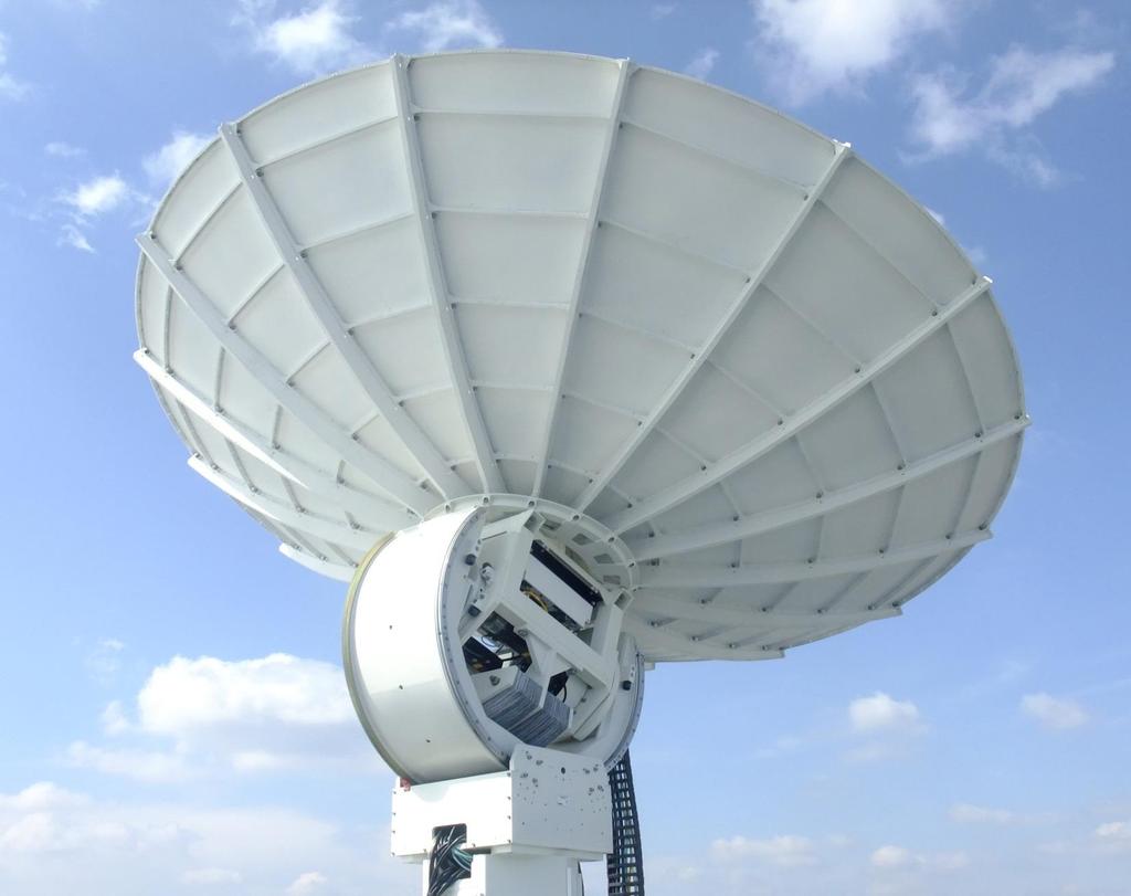
3 TECHNOLOGY Ground Station Dedicated ground station for direct satellite tasking Direct Access Facility (DAF) located near Munich Collection planning and data production from all the DigitalGlobe satellites BENEFITS: Last minute order entry Maximization of collection results Minimize cloud cover Maximize area Maximize collection yield (# targets) Fast production Near real-time delivery


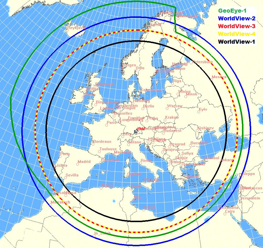
4 TECHNOLOGY Satellites In orbit: WorldView-1 50cm B/W stereo WorldView-2 46cm 8-band color stereo WorldView-3 31cm 8-band color stereo 8-band SWIR WorldView-4 31cm 4-band color GeoEye-1 41cm 4-band color In archive: IKONOS 80 cm 4-band color QuickBird 60 cm 4-band color
5


6 Real-life schedule examples


7 TECHNOLOGY Leading Satellite Constellation Largest fleet of VHR satellites 5 satellites in orbit Highest spatial resolution Up to 31 cm per pixel Highest spectral resolution on VHR satellites 8 spectral bands on WorldView-2 and WorldView extra SWIR bands on WorldView-3 Largest archived collection More than 5 billion km² imagery Historical imagery back to 1999 Growing by more than 3 million km² every day

 1.")
8 Desert Clouds Blue Aerosol Green Red Aerosol Water Water Water Aerosol NDVI Cirrus Snow/Cloud Aerosol-3 PRODUCTS WorldView-3 is the only high-resolution super spectral (> 10 bands) satellite in the industry WORLDVIEW-3 CAVIS BANDS 30m GSD Atmospheric Compensation 3.72m GSD (7.5m releasable) 1.24m GSD WAVELENGTH (NANOMETERS) Pan: 0.31m GSD

9 10m resolution How smallholder fields look at 10m resolution Pixels are heavily mixed between crops and non-crops HR imagery is too coarse for intra-field assessment In-fields scouts needed to get insights 2 hectares Gruol, Germany June 6, 2015 WorldView-3
10 5m resolution? Gruol, Germany June 6, 2015 WorldView-3
11 WorldView-3, 30 cm resolution, PIR1 Red Green Gruol, Germany June 6, 2015 WorldView-3
12 WorldView-3, 30 cm resolution, PIR1 Red Green Hailstorm damages Same crops? Production loss Gruol, Germany June 6, 2015 WorldView-3
13 WorldView-3, 30 cm resolution, PIR2 Yellow Coastal Different crops Gruol, Germany June 6, 2015 WorldView-3

14 CwRS (Control with Remote Sensing) Common Agricultural Policy Checks in the EU Member States EU Common Agriculture Policy (CAP) Provision of financial support to EU farmers Initially focused on export and market support Today used to foster compliance with agri-environmental rules Background Each year, at least 5% of EU farmers claiming direct subsidies are checked Up to 100% of whom are checked by remote sensing Farmers are chosen according to a random risk analysis carried out by the Member States Satellite imagery is provided to the Member States to perform the checks Control with Remote Sensing programme (CwRS) JRC programme for checking farmer s declarations Very high-resolution (VHR) satellite imagery began as a pilot project in 2003
Deliver the imagery within given timeframes Definition of new order parameter profiles (GSD, RMSE, spectral bands, stereo or mono, AOI in")
15 CwRS (Control with Remote Sensing) Common Agricultural Policy Checks in the EU Member States EUSI s tasks are: 1)Liaise with the Member States 2)Manage the incoming Member States AOIs, 3)Collect the data within the varying parameters of each Member States 4)Deliver the imagery within given timeframes Definition of new order parameter profiles (GSD, RMSE, spectral bands, stereo or mono, AOI in mountainous regions or not) Any sensor fitting the requirements may be used in order to increase successful image acquisition WorldView-2 capture (July ) over a CAP control zone of area 228km² in southern Germany with LPIS vector data (yellow) superimposed

16 CwRS (Control with Remote Sensing) Common Agricultural Policy Checks in the EU Member States VHR Image Acquisition Campaign EU Member States + Republic of Macedonia Nearly half a million sq.km 845 agricultural zones spread all over Europe Images collected for over 70% of the zones within two weeks of the window opening Success rate : 100%
17 CwRS (Control with Remote Sensing) Common Agricultural Policy Checks in the EU Member States

18 CwRS (Control with Remote Sensing) Common Agricultural Policy Checks in the EU Member States

19 Tunis, Tunisia October 19, 2017 WorldView-4 Image samples

20 Tunis, Tunisia October 19, 2017 WorldView-4

21 Tunis, Tunisia August 20, 2012 WorldView-2

22 Parc de Sidi Bou Saïd, Tunis, Tunisia August 20, 2012 WorldView-2

23 Tunis, Tunisia October 2, 2016 WorldView-3

24 Tunis, Tunisia October 19, 2017 WorldView-4

25 Tunis, Tunisia October 19, 2017 WorldView-4


26 Thank you for your attention!
Summary of the VHR image acquisition Campaign 2014 and new sensors for 2015
 Summary of the VHR image acquisition Campaign 2014 and new sensors for 2015 Michaela Neumann, George Ellis, Samuel Bärisch, Blanka Vajsova 19 November 2014, Dresden 20th MARS Conference Presentation Outline
European Space Imaging. Your Partner for Very High-Resolution Satellite Imagery GEOGRAPHIC
 European Space Imaging Your Partner for Very High-Resolution Satellite Imagery XVII International User Conference of GeoInformation Systems & Remote Sensing European Space Imaging Your Partner for Very
DigitalGlobe High Resolution Satellite Imagery
 DigitalGlobe High Resolution Satellite Imagery KIAN KANG, SALES MANAGER, SOUTH EAST ASIA & TAIWAN See a better world. DigitalGlobe Overview Over 1,300 employees spanning the globe H E A D Q UA R T E R
EUROPEAN SPACE IMAGING: AERIAL PHOTOGRAPHY QUALITY FROM SPACE ALL TIME ALL CONTINENT
 Senior Adviser to the European Space Imaging GmbH, Munich / Germany European Delegate of DDGI (German Geo-Information Umbrella Association) Member of the Executive Committee of EUROGI (European Umbrella
DIGITALGLOBE SATELLITE IMAGERY AND CLOUD SERVICES FOR SUGARCANE MAPPING
 DIGITALGLOBE SATELLITE IMAGERY AND CLOUD SERVICES FOR SUGARCANE MAPPING PRESENTER: DILLON PANIZZOLO (TECHNICAL MANAGER) COMPANY: GEO DATA DESIGN DATE: 18 TH AUGUST 2015 SASTA Congress Sugar Cane Mapping
News on Image Acquisition for Campaign 2008
 Ispra, 3-4/04/2008 CwRS KO meeting 1 News on Image Acquisition for Campaign 2008 Pär Johan Åstrand, Maria Erlandsson, annian Zhu CID Action Ispra, 3-4/04/2008 CwRS KO meeting 2 Outline of presentation
News on Image Acquisition for the CwRS Campaign new sensors and changes
 Control Methods Workshop: 6-8 / 4 / 2009 [CwRS KO Meeting Campaign 2009] 1 News on Image Acquisition for the CwRS Campaign 2009 - new sensors and changes Pär Johan Åstrand, Joanna Nowak, Maria Erlandsson
The world s most advanced constellation
 The DigitalGlobe Constellation The world s most advanced constellation of very high-resolution satellites The world s most advanced constellation The DigitalGlobe constellation of high-resolution satellites
What can we check with VHR Pan and HR multispectral imagery?
 2008 CwRS Campaign Kick-off meeting, Ispra, 03-04 April 2008 1 What can we check with VHR Pan and HR multispectral imagery? Pavel MILENOV GeoCAP, Agriculture Unit, JRC 2008 CwRS Campaign Kick-off meeting,
Role, Workflow and Challenges
 1 Workshop on checks and management of agricultural land in IACS The actual use of imagery Image Processing at EFTAS Role, Workflow and Challenges Head of IT, Image Processing Unit CwRS 2 The Role 30 years
Lecture 6: Multispectral Earth Resource Satellites. The University at Albany Fall 2018 Geography and Planning
 Lecture 6: Multispectral Earth Resource Satellites The University at Albany Fall 2018 Geography and Planning Outline SPOT program and other moderate resolution systems High resolution satellite systems
Introduction to Remote Sensing Fundamentals of Satellite Remote Sensing. Mads Olander Rasmussen
 Introduction to Remote Sensing Fundamentals of Satellite Remote Sensing Mads Olander Rasmussen (mora@dhi-gras.com) 01. Introduction to Remote Sensing DHI What is remote sensing? the art, science, and technology
Satellite Data Requirements - Copernicus Security Requirements focused on Support to EU External Actions
 European Union Satellite Centre Satellite Data Requirements - Copernicus Security Requirements focused on Support to EU External Actions Brussels, 17 May 2013 Gracia Joyanes Gracia.joyanes@satcen.europa.eu
High resolution satellite imagery a shared and collective data source
 High resolution satellite imagery a shared and collective data source Jean-Philippe Cantou IGN France EFGS forum - Helsinki 16-18 october 2018 1 / 25 ign.fr IGN duties Produce and update the large scale
Introduction to WG5 on CwRS imagery use and alternatives and QE5 on claimed rate inside the RP Peter Viskum Jørgensen, FERV and Birger Faurholt
 Introduction to WG5 on CwRS imagery use and alternatives and QE5 on claimed rate inside the RP Peter Viskum Jørgensen, FERV and Birger Faurholt Pedersen, University of Aarhus, DK CwRS Imagery use and alternatives
ROLE OF SATELLITE DATA APPLICATION IN CADASTRAL MAP AND DIGITIZATION OF LAND RECORDS DR.T. RAVISANKAR GROUP HEAD (LRUMG) RSAA/NRSC/ISRO /DOS HYDERABAD
 RSAA/NRSC/ISRO /DOS HYDERABAD") ROLE OF SATELLITE DATA APPLICATION IN CADASTRAL MAP AND DIGITIZATION OF LAND RECORDS DR.T. RAVISANKAR GROUP HEAD (LRUMG) RSAA/NRSC/ISRO /DOS HYDERABAD WORKSHOP on Best Practices under National Land Records
ROLE OF SATELLITE DATA APPLICATION IN CADASTRAL MAP AND DIGITIZATION OF LAND RECORDS DR.T. RAVISANKAR GROUP HEAD (LRUMG) RSAA/NRSC/ISRO /DOS HYDERABAD WORKSHOP on Best Practices under National Land Records
The DigitalGlobe Constellation. World s Largest Sub-Meter High Resolution Satellite Constellation
 The DigitalGlobe Constellation World s Largest Sub-Meter High Resolution Satellite Constellation The DigitalGlobe Constellation The DigitalGlobe constellation of high resolution satellites offers incredible
Image Acquisition Campaign 2008
 Madrid, 12-14 November, 2007 Geomatics in Support of the CAP 1 Image Acquisition Campaign 2008 Pär Johan Åstrand, Maria Erlandsson Mihaela Fotin, Cherith Aspinall JRC, CID JRC, CID Madrid, 12-14 November,
E m e r g e n c y M a n a g e m e n t S e r v i c e. C o p e r n i c u s A e r i a l c o m p o n e n t s t a t u s s t u d y
 E m e r g e n c y M a n a g e m e n t S e r v i c e C o p e r n i c u s A e r i a l c o m p o n e n t s t a t u s s t u d y Peter Spruyt European Commission Joint Research Centre EMS Mapping User Workshop
2010 Image acquisition campaign
 2010 Image acquisition campaign Eugenio Gervasini, Blanka Vajsová, Simone Gentilini, Cherith Aspinall, Pär Ästrand, Juergen Breunig - CID, MARS Unit, JRC Ispra OUTLINE: 2010 Campaign overview: HR VHR Expenditure
Our Quality Promise WHITE PAPER
 Our Quality Promise www.digitalglobe.com Corporate (U.S.) +1.303.684.4561 or +1.800.496.1225 London +44.20.8899.6801 Singapore +65.6389.4851 To ensure your success, we put quality at our core At DigitalGlobe,
WorldView-2. WorldView-2 Overview
 WorldView-2 WorldView-2 Overview 6/4/09 DigitalGlobe Proprietary 1 Most Advanced Satellite Constellation Finest available resolution showing crisp detail Greatest collection capacity Highest geolocation
CHARACTERISTICS OF REMOTELY SENSED IMAGERY. Spatial Resolution
 CHARACTERISTICS OF REMOTELY SENSED IMAGERY Spatial Resolution There are a number of ways in which images can differ. One set of important differences relate to the various resolutions that images express.
LPIS Orthoimagery An assessment of the Bing imagery for LPIS purpose
 LPIS Orthoimagery An assessment of the Bing imagery for LPIS purpose Slavko Lemajić Wim Devos, Pavel Milenov GeoCAP Action - MARS Unit - JRC Ispra Tallinn, 24 th November 2011 Outline JRC`s Ortho specifications
The studies began when the Tiros satellites (1960) provided man s first synoptic view of the Earth s weather systems.
 provided man s first synoptic view of the Earth s weather systems.") Remote sensing of the Earth from orbital altitudes was recognized in the mid-1960 s as a potential technique for obtaining information important for the effective use and conservation of natural resources.
Remote sensing of the Earth from orbital altitudes was recognized in the mid-1960 s as a potential technique for obtaining information important for the effective use and conservation of natural resources.
EVALUATION OF PLEIADES-1A TRIPLET ON TRENTO TESTFIELD
 EVALUATION OF PLEIADES-1A TRIPLET ON TRENTO TESTFIELD D. Poli a, F. Remondino b, E. Angiuli c, G. Agugiaro b a Terra Messflug GmbH, Austria b 3D Optical Metrology Unit, Fondazione Bruno Kessler, Trento,
INFORMATION CONTENT ANALYSIS FROM VERY HIGH RESOLUTION OPTICAL SPACE IMAGERY FOR UPDATING SPATIAL DATABASE
 INFORMATION CONTENT ANALYSIS FROM VERY HIGH RESOLUTION OPTICAL SPACE IMAGERY FOR UPDATING SPATIAL DATABASE M. Alkan a, * a Department of Geomatics, Faculty of Civil Engineering, Yıldız Technical University,
Satellite Imagery Characteristics, Uses and Delivery to GIS Systems. Wayne Middleton April 2014
 Satellite Imagery Characteristics, Uses and Delivery to GIS Systems Wayne Middleton April 2014 About Geoimage Founded in Brisbane 1988 Leading Independent company Specialists in satellite imagery and geospatial
US Commercial Imaging Satellites
 US Commercial Imaging Satellites In the early 1990s, Russia began selling 2-meter resolution product from its archives of collected spy satellite imagery. Some of this product was down-sampled to provide
Advanced Techniques in Urban Remote Sensing
 Advanced Techniques in Urban Remote Sensing Manfred Ehlers Institute for Geoinformatics and Remote Sensing (IGF) University of Osnabrueck, Germany mehlers@igf.uni-osnabrueck.de Contents Urban Remote Sensing:
Geology, Exploration, and WorldView-3 SWIR Kumar Navulur, PhD
 Geology, Exploration, and WorldView-3 SWIR Kumar Navulur, PhD Mt Everest Digital Elevation Model 0.5 m WorldView 2 2m False Color IR Drape DigitalGlobe Proprietary. DigitalGlobe. All rights reserved. Agenda
TechTime New Mapping Tools for Transportation Engineering
 GeoEye-1 Stereo Satellite Imagery Presented by Karl Kliparchuk, M.Sc., GISP kkliparchuk@mcelhanney.com 604-683-8521 All satellite imagery are copyright GeoEye Corp GeoEye-1 About GeoEye Corp Headquarters:
Satellite imagery for CWRS from Irish perspective. Speaker: Aleksandra Kocon Author: Aleksandra Kocon
 Satellite imagery for CWRS from Irish perspective Speaker: Aleksandra Kocon Author: Aleksandra Kocon aleksandra@icon.ie Introduction Long acquisition windows / windows fitting with crop cycle problem Main
Croatian ideas on simplifying the CAP
 PAYING AGENCY IN AGRICULTURE, FISHERIES AND RURAL DEVELOPMENT Croatian ideas on simplifying the CAP Karlo Banović, Sector for OTS control 2017 IACS Workshop, Ghent 30.5.2017 Contents Current use new technologies
The use of satellite images to forecast agricultural
 The use of satellite images to forecast agricultural Luxembourg, 12.03.2014 r. Tomasz Milewski NUTS for Poland: NUTS 1 macro-regions (grup of province, voivodships) (6), NUTS 2 - regions (province,
GMES DA COPERNICUS
 2014 Airbus Defence and Space All rights reserved. The reproduction, distribution and utilization of this document as well as the communication of its contents to others without express authorization is
VHR Image Acquisition Specifications for the CAP Controls (CwRS and LPIS QA)
") EUROPEAN COMMISSION JOINT RESEARCH CENTRE Institute for Environment and Sustainability Monitoring Agricultural ResourceS Unit JRC IES/H04/C/PAR/par / Specifications VHR Image Acquisition Specifications
EUROPEAN COMMISSION JOINT RESEARCH CENTRE Institute for Environment and Sustainability Monitoring Agricultural ResourceS Unit JRC IES/H04/C/PAR/par / Specifications VHR Image Acquisition Specifications
Big picture with KOMPSAT KOMPSAT-3A / KOMPSAT-3 / KOMPSAT-5 / KOMPSAT-2
 Big picture with KOMPSAT KOMPSAT-3A / KOMPSAT-3 / KOMPSAT-5 / KOMPSAT-2 Big picture with KOMPSAT Introduction SI Imaging Services (SIIS) is the exclusive worldwide marketing and sales representative of
Update on Landsat Program and Landsat Data Continuity Mission
 Update on Landsat Program and Landsat Data Continuity Mission Dr. Jeffrey Masek LDCM Deputy Project Scientist NASA GSFC, Code 923 November 21, 2002 Draft LDCM Implementation Phase RFP Overview Page 1 Celebrate!
Topographic mapping from space K. Jacobsen*, G. Büyüksalih**
 Topographic mapping from space K. Jacobsen*, G. Büyüksalih** * Institute of Photogrammetry and Geoinformation, Leibniz University Hannover ** BIMTAS, Altunizade-Istanbul, Turkey KEYWORDS: WorldView-1,
Introduction to KOMPSAT
 Introduction to KOMPSAT September, 2016 1 CONTENTS 01 Introduction of SIIS 02 KOMPSAT Constellation 03 New : KOMPSAT-3 50 cm 04 New : KOMPSAT-3A 2 KOMPSAT Constellation KOMPSAT series National space program
VHR Image Specifications for the CwRS Programme Campaign Pär Johan Åstrand Maria Erlandsson
 VHR Image Specifications for the CwRS Programme Campaign 2009 Pär Johan Åstrand Maria Erlandsson EUR 23404 EN/2-2009 The mission of the JRC-IPSC is to provide research results and to support EU policy-makers
Introduction of Satellite Remote Sensing
 Introduction of Satellite Remote Sensing Spatial Resolution (Pixel size) Spectral Resolution (Bands) Resolutions of Remote Sensing 1. Spatial (what area and how detailed) 2. Spectral (what colors bands)
VHR Image Specifications for the CwRS Programme Campaign 2008
 VHR Image Specifications for the CwRS Programme Campaign 2008 Pär-Johan Åstrand, Maria Erlandsson EUR 23404 EN - 2008 The Institute for the Protection and Security of the Citizen provides research-based,
HARRIS GEOSPATIAL MARKETPLACE. HarrisGeospatial.com
 HARRIS GEOSPATIAL MARKETPLACE HarrisGeospatial.com Satellite image of Washington, D.C. Image courtesy of DigitalGlobe GET IT ALL IN ONE PLACE Data for Any Project Map Products Vis/Sim Products Geospatial
VHR image acquisition specifications for the CAP checks (CwRS and LPIS QA) - VHR profile-based specifications including VHR+ profiles.
 - VHR profile-based specifications including VHR+ profiles.") JRC IES/H06/C/PAR/par D(2014)(17359) VHR image acquisition specifications for the CAP checks (CwRS and LPIS QA) - including VHR+ profiles Campaign 2015 Author: Pär Johan Åstrand Status: V7.4 Co-authors:
JRC IES/H06/C/PAR/par D(2014)(17359) VHR image acquisition specifications for the CAP checks (CwRS and LPIS QA) - including VHR+ profiles Campaign 2015 Author: Pär Johan Åstrand Status: V7.4 Co-authors:
9/12/2011. Training Course Remote Sensing Basic Theory & Image Processing Methods September 2011
 Training Course Remote Sensing Basic Theory & Image Processing Methods 19 23 September 2011 Popular Remote Sensing Sensors & their Selection Michiel Damen (September 2011) damen@itc.nl 1 Overview Low resolution
VHR image acquisition specifications for the CAP checks (CwRS and LPIS QA) - VHR profile-based specifications including VHR+ profiles
 - VHR profile-based specifications including VHR+ profiles") JRC/IES/H06/2015/21449 VHR image acquisition specifications for the CAP checks (CwRS and LPIS QA) - including VHR+ profiles Campaign 2016 Text highlighted in YELLOW contains changes from 2015 Author: Pär
JRC/IES/H06/2015/21449 VHR image acquisition specifications for the CAP checks (CwRS and LPIS QA) - including VHR+ profiles Campaign 2016 Text highlighted in YELLOW contains changes from 2015 Author: Pär
Some elements on On-The-Spot Checks (OTSC) and area measurement
 and area measurement") Some elements on On-The-Spot Checks (OTSC) and area measurement DSCG/2014/32 FINAL Philippe LOUDJANI MARS (Monitoring Agricultural Resources) Unit DG Joint Research Centre Evidence-based scientific and
Some elements on On-The-Spot Checks (OTSC) and area measurement DSCG/2014/32 FINAL Philippe LOUDJANI MARS (Monitoring Agricultural Resources) Unit DG Joint Research Centre Evidence-based scientific and
Satellite Monitoring of a Large Tailings Storage Facility
 Satellite Monitoring of a Large Tailings Storage Facility Benjamin Schmidt and Matt Malgesini, Golder Associates Inc., USA Jim Turner, PhotoSat Ltd, Canada Jeff Reinson, Goldcorp Inc., Canada Presentation
Automated Damage Analysis from Overhead Imagery
 Automated Damage Analysis from Overhead Imagery EVAN JONES ANDRE COLEMAN SHARI MATZNER Pacific Northwest National Laboratory 1 PNNL FY2015 at a Glance $955 million in R&D expenditures 4,400 scientists,
Sentinel-2 Products and Algorithms
 Sentinel-2 Products and Algorithms Ferran Gascon (Sentinel-2 Data Quality Manager) Workshop Preparations for Sentinel 2 in Europe, Oslo 26 November 2014 Sentinel-2 Mission Mission Overview Products and
Regulatory Perspectives for NewSpace in Canada
 Regulatory Perspectives for NewSpace in Canada Feb 24, 2017 Mike Safyan Director of Launch & Regulatory Affairs Planet History The Dove Satellite Planet Satellite Fleet CONSTELLATION DOVE RAPIDEYE Constellation
DEM GENERATION WITH WORLDVIEW-2 IMAGES
 DEM GENERATION WITH WORLDVIEW-2 IMAGES G. Büyüksalih a, I. Baz a, M. Alkan b, K. Jacobsen c a BIMTAS, Istanbul, Turkey - (gbuyuksalih, ibaz-imp)@yahoo.com b Zonguldak Karaelmas University, Zonguldak, Turkey
NON-PHOTOGRAPHIC SYSTEMS: Multispectral Scanners Medium and coarse resolution sensor comparisons: Landsat, SPOT, AVHRR and MODIS
 NON-PHOTOGRAPHIC SYSTEMS: Multispectral Scanners Medium and coarse resolution sensor comparisons: Landsat, SPOT, AVHRR and MODIS CLASSIFICATION OF NONPHOTOGRAPHIC REMOTE SENSORS PASSIVE ACTIVE DIGITAL
Application of Satellite Remote Sensing for Natural Disasters Observation
 Application of Satellite Remote Sensing for Natural Disasters Observation Prof. Krištof Oštir, Ph.D. University of Ljubljana Faculty of Civil and Geodetic Engineering Outline Earth observation current
Optimizing Multiresolution Segmentation for Extracting Plastic Greenhouses from WorldView 3 Imagery
 Optimizing Multiresolution Segmentation for Extracting Plastic Greenhouses from WorldView 3 Imagery Manuel A. Aguilar, Antonio Novelli, Abderrahim Nemmaoui, Fernando J. Aguilar, Andrés García Lorca, Óscar
VHR image acquisition specifications for the CAP checks (CwRS and LPIS QA) - VHR profile-based specifications including VHR+ profiles.
 - VHR profile-based specifications including VHR+ profiles.") JRC/IES/H06/2015/21449 VHR image acquisition specifications for the CAP checks (CwRS and LPIS QA) - including VHR+ profiles Campaign 2016 Text highlighted in YELLOW contains changes from 2015 Author: Pär
JRC/IES/H06/2015/21449 VHR image acquisition specifications for the CAP checks (CwRS and LPIS QA) - including VHR+ profiles Campaign 2016 Text highlighted in YELLOW contains changes from 2015 Author: Pär
IKONOS High Resolution Multispectral Scanner Sensor Characteristics
 High Spatial Resolution and Hyperspectral Scanners IKONOS High Resolution Multispectral Scanner Sensor Characteristics Launch Date View Angle Orbit 24 September 1999 Vandenberg Air Force Base, California,
RADIOMETRIC AND GEOMETRIC CHARACTERISTICS OF PLEIADES IMAGES
 RADIOMETRIC AND GEOMETRIC CHARACTERISTICS OF PLEIADES IMAGES K. Jacobsen a, H. Topan b, A.Cam b, M. Özendi b, M. Oruc b a Leibniz University Hannover, Institute of Photogrammetry and Geoinformation, Germany;
DIGITALGLOBE ATMOSPHERIC COMPENSATION
 See a better world. DIGITALGLOBE BEFORE ACOMP PROCESSING AFTER ACOMP PROCESSING Summary KOBE, JAPAN High-quality imagery gives you answers and confidence when you face critical problems. Guided by our
TESTFIELD TRENTO: GEOMETRIC EVALUATION OF VERY HIGH RESOLUTION SATELLITE IMAGERY
 TESTFIELD TRENTO: GEOMETRIC EVALUATION OF VERY HIGH RESOLUTION SATELLITE IMAGERY G. AGUGIAROa, D. POLIb, F. REMONDINOa, 3DOM, 3D Optical Metrology Unit Bruno Kessler Foundation, Trento, Italy a b Vermessung
The studies began when the Tiros satellites (1960) provided man s first synoptic view of the Earth s weather systems.
 provided man s first synoptic view of the Earth s weather systems.") Remote sensing of the Earth from orbital altitudes was recognized in the mid-1960 s as a potential technique for obtaining information important for the effective use and conservation of natural resources.
Remote sensing of the Earth from orbital altitudes was recognized in the mid-1960 s as a potential technique for obtaining information important for the effective use and conservation of natural resources.
ENMAP RADIOMETRIC INFLIGHT CALIBRATION, POST-LAUNCH PRODUCT VALIDATION, AND INSTRUMENT CHARACTERIZATION ACTIVITIES
 ENMAP RADIOMETRIC INFLIGHT CALIBRATION, POST-LAUNCH PRODUCT VALIDATION, AND INSTRUMENT CHARACTERIZATION ACTIVITIES A. Hollstein1, C. Rogass1, K. Segl1, L. Guanter1, M. Bachmann2, T. Storch2, R. Müller2,
CORN BEST MANAGEMENT PRACTICES CHAPTER 22. Matching Remote Sensing to Problems
 CORN BEST MANAGEMENT PRACTICES CHAPTER 22 USDA photo by Regis Lefebure Matching Remote Sensing to Problems Jiyul Chang (Jiyul.Chang@sdstate.edu) and David Clay (David.Clay@sdstate.edu) Remote sensing can
REVIEW OF ENMAP SCIENTIFIC POTENTIAL AND PREPARATION PHASE
 REVIEW OF ENMAP SCIENTIFIC POTENTIAL AND PREPARATION PHASE H. Kaufmann 1, K. Segl 1, L. Guanter 1, S. Chabrillat 1, S. Hofer 2, H. Bach 3, P. Hostert 4, A. Mueller 5, and C. Chlebek 6 1 Helmholtz Centre
MULTIPURPOSE QUADCOPTER SOLUTION FOR AGRICULTURE
 MULTIPURPOSE QUADCOPTER SOLUTION FOR AGRICULTURE Powered by COVERS UP TO 30HA AT 70M FLIGHT ALTITUDE PER BATTERY PHOTO & VIDEO FULL HD 1080P - 14MP 3-AXIS STABILIZATION INCLUDES NDVI & ZONING MAPS SERVICE
MERIS instrument. Muriel Simon, Serco c/o ESA
 MERIS instrument Muriel Simon, Serco c/o ESA Workshop on Sustainable Development in Mountain Areas of Andean Countries Mendoza, Argentina, 26-30 November 2007 ENVISAT MISSION 2 Mission Chlorophyll case
DISCO-PRO AG ALL-IN-ONE DRONE SOLUTION FOR PRECISION AGRICULTURE. 80ha COVERAGE PARROT SEQUOIA INCLUDES MULTI-PURPOSE TOOL SAFE ANALYZE & DECIDE
 DISCO-PRO AG ALL-IN-ONE DRONE SOLUTION FOR PRECISION AGRICULTURE Powered by 80ha COVERAGE AT 120M * FLIGHT ALTITUDE (200AC @ 400FT) MULTI-PURPOSE TOOL PHOTO 14MPX VIDEO 1080P FULL HD PARROT SEQUOIA RGB
Integrating Spaceborne Sensing with Airborne Maritime Surveillance Patrols
 22nd International Congress on Modelling and Simulation, Hobart, Tasmania, Australia, 3 to 8 December 2017 mssanz.org.au/modsim2017 Integrating Spaceborne Sensing with Airborne Maritime Surveillance Patrols
UNOSAT Satellite Imagery and GIS Solutions for DRR and Emergency Management
 UNOSAT Satellite Imagery and GIS Solutions for DRR and Emergency Management Francesco Pisano Director, Research, Technology Applications & Knowledge Systems January 2013 Introduction to UNOSAT 2 About
Lecture 7 Earth observation missions
 Remote sensing for agricultural applications: principles and methods (2013-2014) Instructor: Prof. Tao Cheng (tcheng@njau.edu.cn). Nanjing Agricultural University Lecture 7 Earth observation missions May
Title of presentation runs here on two lines / Arial Regular 30 pt
 Title of presentation runs here on two lines / Arial Regular 30 pt Subtitle goes here / Arial Regular 20 pt Airbus Defense and Space Geo-Intelligence PIONEERING THE FUTURE TOGETHER Name Here / Arial Regular
VENµS: A Joint French Israeli Earth Observation Scientific Mission with High Spatial and Temporal Resolution Capabilities
 VENµS: A Joint French Israeli Earth Observation Scientific Mission with High Spatial and Temporal Resolution Capabilities G. Dedieu 1, A. Karnieli 2, O. Hagolle 3, H. Jeanjean 3, F. Cabot 3, P. Ferrier
Satellite Fleet for a Commercial Remote Sensing Company
 Satellite Fleet for a Commercial Remote Sensing Company Application Portfolio Danielle Wood December 5, 2007 Danielle Wood Page 1 of 16 December 5, 2007 Abstract This study considers the impacts of uncertainty
The Most Suitable Sizes Of Ground Control Points (Gcps) For World View2
 For World View2") The Most Suitable Sizes Of Ground Control Points (Gcps) For World View2 Dr. O. Mutluoglu Dr.M. Yakar Dr. H.M. Yilmaz 1 INTRODUCTION High resolution satellite images, (less than 1 m. Resolution) are used
The Most Suitable Sizes Of Ground Control Points (Gcps) For World View2 Dr. O. Mutluoglu Dr.M. Yakar Dr. H.M. Yilmaz 1 INTRODUCTION High resolution satellite images, (less than 1 m. Resolution) are used
Kongsberg Satellite Services, KSAT
 SvalSat, Earth Station at 78 North Kongsberg Satellite Services, KSAT Making Sense of Space Sigmund Dehli International Sales Manager WORLD CLASS through people, technology and dedication My plan KSAT
ISRO s EARTH OBSERVATION SYSTEM (updates from last Plenary) AS Kiran Kumar ISRO, INDIA
 AS Kiran Kumar ISRO, INDIA") ISRO s EARTH OBSERVATION SYSTEM (updates from last Plenary) AS Kiran Kumar ISRO, INDIA The 24 th CEOS Plenary Rio de Janeiro, Brazil 12-15 October, 2010 1 Four Decades of Indian Space Programme 30LV Missions
ISRO s EARTH OBSERVATION SYSTEM (updates from last Plenary) AS Kiran Kumar ISRO, INDIA The 24 th CEOS Plenary Rio de Janeiro, Brazil 12-15 October, 2010 1 Four Decades of Indian Space Programme 30LV Missions
Resurs-P Earth Remote Sensing constellation A. Kirilin, R. Akhmetov, N. Stratilatov, A. Baklanov JSC Space-Rocket Centre PROGRESS, Samara, Russia
 17 th International Scientific and Technical Conference FROM IMAGERY TO DIGITAL REALITY: ERS & Photogrammetry Resurs-P Earth Remote Sensing constellation A. Kirilin, R. Akhmetov, N. Stratilatov, A. Baklanov
Remote Sensing. Odyssey 7 Jun 2012 Benjamin Post
 Remote Sensing Odyssey 7 Jun 2012 Benjamin Post Definitions Applications Physics Image Processing Classifiers Ancillary Data Data Sources Related Concepts Outline Big Picture Definitions Remote Sensing
Can Satellite Image Analysis Replace Manual Digitization?
 Can Satellite Image Analysis Replace Manual Digitization? GeoDATA London 30 th Nov 2017 LUCY KENNEDY Spottitt CEO Lucy.Kennedy@spottitt.com +44 772 594 4643 Agenda Why develop processes and services based
KOMPSAT Constellation. November 2012 Satrec Initiative
 KOMPSAT Constellation November 2012 Satrec Initiative KOMPSAT Constellation KOMPSAT National program Developed and operated by KARI (Korea Aerospace Research Institute) Dual use : Government & commercial
On the use of water color missions for lakes in 2021
 Lakes and Climate: The Role of Remote Sensing June 01-02, 2017 On the use of water color missions for lakes in 2021 Cédric G. Fichot Department of Earth and Environment 1 Overview 1. Past and still-ongoing
Introduction to Remote Sensing
 Introduction to Remote Sensing Spatial, spectral, temporal resolutions Image display alternatives Vegetation Indices Image classifications Image change detections Accuracy assessment Satellites & Air-Photos
Satellite Imagery and Remote Sensing. DeeDee Whitaker SW Guilford High EES & Chemistry
 Satellite Imagery and Remote Sensing DeeDee Whitaker SW Guilford High EES & Chemistry whitakd@gcsnc.com Outline What is remote sensing? How does remote sensing work? What role does the electromagnetic
Abstract Quickbird Vs Aerial photos in identifying man-made objects
 Abstract Quickbird Vs Aerial s in identifying man-made objects Abdullah Mah abdullah.mah@aramco.com Remote Sensing Group, emap Division Integrated Solutions Services Department (ISSD) Saudi Aramco, Dhahran
Acquisition of Aerial Photographs and/or Satellite Imagery
 Acquisition of Aerial Photographs and/or Satellite Imagery Acquisition of Aerial Photographs and/or Imagery From time to time there is considerable interest in the purchase of special-purpose photography
Monitoring Natural Disasters with Small Satellites Smart Satellite Based Geospatial System for Environmental Protection
 Monitoring Natural Disasters with Small Satellites Smart Satellite Based Geospatial System for Environmental Protection Krištof Oštir, Space-SI, Slovenia Contents Natural and technological disasters Current
A CONCEPT FOR NATURAL GAS TRANSMISSION PIPELINE MONITORING BASED ON NEW HIGH-RESOLUTION REMOTE SENSING TECHNOLOGIES
 A CONCEPT FOR NATURAL GAS TRANSMISSION PIPELINE MONITORING BASED ON NEW HIGH-RESOLUTION REMOTE SENSING TECHNOLOGIES Werner Zirnig - Ruhrgas Aktiengesellschaft Dieter Hausamann - DLR German Aerospace Center
Summary. Introduction. Remote Sensing Basics. Selecting a Remote Sensing Product
 K. Dalsted, J.F. Paris, D.E. Clay, S.A. Clay, C.L. Reese, and J. Chang SSMG-40 Selecting the Appropriate Satellite Remote Sensing Product for Precision Farming Summary Given the large number of satellite
Satellite monitoring of a large tailings storage facility
 ABSTRACT Satellite monitoring of a large tailings storage facility Benjamin Schmidt, Matt Malgesini Golder Associates Inc., USA Jim Turner PhotoSat Ltd, Canada Jeff Reinson Goldcorp Inc., Canada Minera
Lesson 3: Working with Landsat Data
 Lesson 3: Working with Landsat Data Lesson Description The Landsat Program is the longest-running and most extensive collection of satellite imagery for Earth. These datasets are global in scale, continuously
School of Rural and Surveying Engineering National Technical University of Athens
 Laboratory of Photogrammetry National Technical University of Athens Combined use of spaceborne optical and SAR data Incompatible data sources or a useful procedure? Charalabos Ioannidis, Dimitra Vassilaki
CHARACTERISTICS OF VERY HIGH RESOLUTION OPTICAL SATELLITES FOR TOPOGRAPHIC MAPPING
 CHARACTERISTICS OF VERY HIGH RESOLUTION OPTICAL SATELLITES FOR TOPOGRAPHIC MAPPING K. Jacobsen Leibniz University Hannover, Institute of Photogrammetry and Geoinformation jacobsen@ipi.uni-hannover.de Commission
MOVING FROM PIXELS TO PRODUCTS
 TRUE COLOR RGB MOSAIC, OSAKA, JAPAN MOVING FROM PIXELS TO PRODUCTS and data to insight AUTOMATED STRUCTURE IDENTIFICATION, OSAKA, JAPAN Table of Contents Moving from Pixels to Products 3 Doubling the Spectral
Earth Observation at Spin.Works
 Earth Observation at Spin.Works H2020 Space Information Day Lisboa September 29, 2016 Spin.Works, S.A. Av. Da Igreja nº42 6º 1700-239 Lisboa Phone/Fax +351 21 012 8452 info@spinworks.pt www.spinworks.pt
The Normal Baseline. Dick Gent Law of the Sea Division UK Hydrographic Office
 The Normal Baseline Dick Gent Law of the Sea Division UK Hydrographic Office 2 The normal baseline for measuring the breadth of the territorial sea is the low water line along the coast as marked on large
Rapideye (2008 -> ) Not just another high resolution satellite sensor. 5 satellites RapidEye constellation. 5 million km² daily collection capacity
 Not just another high resolution satellite sensor. 5 satellites RapidEye constellation. 5 million km² daily collection capacity") Rapideye (2008 -> ) Not just another high resolution satellite sensor 5 satellites RapidEye constellation 5 million km² daily collection capacity Price: $1.40 / sq km ($2.50 rectified) Orbit: http://www.youtube.com/watch?feature=player_embedded&v=ovpulctoqgs
Rapideye (2008 -> ) Not just another high resolution satellite sensor 5 satellites RapidEye constellation 5 million km² daily collection capacity Price: $1.40 / sq km ($2.50 rectified) Orbit: http://www.youtube.com/watch?feature=player_embedded&v=ovpulctoqgs
WHAT IS NEXT IN EARTH OBSERVATION. SkyMed Mission
 WHAT IS NEXT IN EARTH OBSERVATION COSMO-SkyMed SkyMed Mission Paolo Ammendola Italian Space Agency Florence, Sept. 19, 2001 ammendola@asi asi.it THE NEEDS Market studies indicate that the value of the
Futrajaya, Malaysia JULY 12, Jeong Heon SONG. Korea Aerospace Research Institution
 J P T M 2 0 1 1 Futrajaya, Malaysia JULY 12, 2011 Jeong Heon SONG Korea Aerospace Research Institution Outline Contribution of KARI Sentinel Asia / Data Provider Node International Charter KARI Space Activities