Field test of simultaneous gyro attitude reference for magnetic ranging measurements in a near vertical magnetically perturbed environment
|
|
|
- Mary Robbins
- 5 years ago
- Views:
Transcription
1 Field test of simultaneous gyro attitude reference for magnetic ranging measurements in a near vertical magnetically perturbed environment Georgy Rassadkin Scientific Drilling International September 2017
2 Agenda Introduction What is magnetic ranging? How is gyro attitude referencing done? Field test #1. Solenoid based ranging system Field test #2. Rotating dipole at bit while drilling ranging system Summary of results
3
4 Georgy Rassadkin. Biography M.Sc., Applied Geophysics, Dubna International University 7 years in gyro and MWD surveying and magnetic ranging Currently work as a training instructor in Scientific Drilling International in Houston
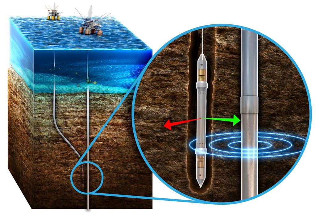
5 What is magnetic ranging? Using a magnetic field (other than the Earth s field) to determine the distance and direction between wellbores Source A magnetic field generator (solenoid, rare earth magnet, current on a wire or casing) Receiver MWD magnetometer package Wireline magnetometer package

 is BAD HSTF =??? Calculated: AzTF = Azim + HSTF =?")
6 Why gyro attitude referencing? NORTH From prior survey: Inc = 40 deg Azim = 90 deg From tool: Inc = 40 deg Azim is BAD AzTF(MTF) is BAD HSTF = 90 deg DOWN Tool highside From prior survey: Inc = 0 deg Azim =??? From tool: Inc = 0 deg Azim =??? AzTF(MTF) is BAD HSTF =??? Calculated: AzTF = Azim + HSTF =? +? =??? Calculated: AzTF = Azim + HSTF = = = 180 deg AzTF (GyTF) = 180 deg

 and")
7 How is gyro attitude referencing done? North-seeking gyro is included into a ranging receiver assembly All sections are rigidly connected All sensor packages aligned to the same tool highside True North gyro data (Inc, Azim, AzTF/GyTF, HSTF) and magnetic ranging data collected and processed together

 Well #2 gyromwd Well #1")
8 Field test #1. Solenoid based ranging system Two vertical wells Client requested 4.7m +/-0.65m separation at TD (~500m) Well #2 gyromwd Well #1 MWD 2m 8m Conventional survey accuracy +/-3m at TD Ranging accuracy +/- 0.15m
9 Field test #1. Gyro orientation vs magnetic orientation Magnetic orientation is inaccurate due to interference from nearby casing Gyro is not affected by the magnetic interference

10 Field test #1. Gyro orientation vs magnetic orientation Grey reference well Red magnetic oriented ranging shots Blue gyro oriented ranging shots
11 Field test #1. Gyro orientation vs magnetic orientation Travelling cylinder m MD Blue gyro oriented ranging Red magnetic oriented ranging

12 Field test #1. Simultaneous gyro referencing gives 10x improvement of ranging accuracy The spread of magnetic oriented ranging shots is large (on the left) Gyro orientation provides consistent ranging results (on the right)


13 Field test #2. Rotating dipole at bit while drilling ranging The objective was to safely pass by a vertical well while drilling a horizontal well in close proximity 2 sigma uncertainty for the MWD surveys at horizontal was too large The normal industry practice is to use prior survey and the tool highside for ranging orientation
14 Field test #2. Simultaneous gyro orientation vs interpolated prior survey Azimuth interpolated to the sensor depth from a previous survey fails to provide accurate NEV orientation at vertical North-seeking rate gyro rigidly connected and aligned with ranging assembly solves this problem vertical well with the ranging assembly inside ranged position oriented via: simultaneous gyro interpolated prior survey OWSG MWD+IFR2+MSA
15 Northing, m Field test #2. Simultaneous gyro referencing multiplies ranging accuracy Accuracy improved over 2.5 times comparing to previous method Simultaneous Gyro Orientation Orientation from interpolated prior survey Easting, m Horizontal scatter of the vertical well position near the pass by derived from the MWD surveys plus ranging shots at the total separation of 50m and less -692
16 Summary of results Contemporaneous gyro measurements can improve magnetic ranging accuracy by up to 10-fold over previous methods The described technique is an effective solution when magnetic ranging performed in vertical magnetically perturbed environment The applications for the described technique include o relief well drilling o plug and abandonment o collision avoidance/risk mitigation o civil and mining projects
17 Thank you! Questions?
SPE MS. Combined Gyroscopic and Magnetic Surveys Provide Improved Magnetic Survey Data and Enhanced Survey Quality Control
 1 SPE-194130-MS Combined Gyroscopic and Magnetic Surveys Provide Improved Magnetic Survey Data and Enhanced Survey Quality Control John Weston, Adrián Ledroz Gyrodata Inc. 2 Contents Description of new
The method uses a combination of drilling techniques and specialized logging services and tools. These are:
 LWD/MWD Proximity Techniques for Relief Well Projects By: L. William (Bill) Abel P.E. Abel Engineering, Houston, Texas & James N. Towle, PhD., P.E. Scientific Drilling Inc., Houston, Texas INTRODUCTION
Using Magnetic MWD near Existing Casing
 Using Magnetic MWD near Existing Casing Neil Bergstrom, Senior Technical Advisor Magnetic Variation, LLC (MagVAR) Denver, Colorado USA 1 Magnetic Variation Services, LLC and SURCON, LLC MagVAR creates
Recommendations for Improvements to Wellbore Surveying and Ranging Regulations
 Recommendations for Improvements to Wellbore Surveying and Ranging Regulations Presented at the Public Technology Assessment Program (TAP) Forum February 17, 2017 Prepared for: US Department of Interior,
Non-Magnetic Spacing with Axial corrections
 Dallas, USA Slide 1 Non-Magnetic Spacing with Axial corrections How close can I get the MWD sensor to the bit? A guide to methodology Neil Bergstrom, P.E. Speaker Information Neil Bergstrom, P.E. Senior
A Comparison of Active and Passive Magnetic Ranging Techniques in a Relief Well Application
 A Comparison of Active and Passive Magnetic Ranging Techniques in a Relief Well Application Clinton Moss Halliburton Sperry Drilling SPE Wellbore Positioning Technical Section Meeting #36 Oct 11 th, 2012
MWD Standard Directional MWD Service
 MWD Standard Directional MWD Service Provides reliable Directional MWD measurements in hole sizes down to 5-7/8 diameter. (9-1/2-4-3/4 Collar Sizes). Transmits: Hole Inclination, Azimuth, Tool Face & Circulating
AADE-11-NTCE- 49. Producing the Marcellus Shale: Field Experience in Pad Drilling Techniques
 AADE-11-NTCE- 49 Producing the Marcellus Shale: Field Experience in Pad Drilling Techniques Benny Poedjono, John Zabaldano, Irina Shevchenko, and Christopher Jamerson, Schlumberger; and Robert Kuntz and
API RP 78 Overview RECOMMENDED PRACTICES FOR WELLBORE POSITIONING 3/4/2016 PRESENTED BY LISA GRANT AT THE ISCWSA/SPE WPTS 43RD GENERAL MEETING
 API RP 78 Overview RECOMMENDED PRACTICES FOR WELLBORE POSITIONING Why are we doing this? The OWSG committee recognized a need for a comprehensive body of work that defined a minimum standard and formed
The line passing through the two coincident angular markings give us bent sub tool face, i.e. the orientation of our bent sub or mud motor.
 The line passing through the two coincident angular markings give us bent sub tool face, i.e. the orientation of our bent sub or mud motor. Now our next job is orient our MWD/LWD tool in the direction
Welcome to the 45 th Meeting of the ISCWSA
 Welcome to the 45 th Meeting of the ISCWSA March 17, 2017 1 SAFETY & LOGISTICS BRIEFING Exits Alarms I.C.E. In Case of Emergency Medical Muster Area Restrooms Lunch Location 2 SAFETY & LOGISTICS BRIEFING
This presentation was prepared as part of Sensor Geophysical Ltd. s 2010 Technology Forum presented at the Telus Convention Center on April 15, 2010.
 This presentation was prepared as part of Sensor Geophysical Ltd. s 2010 Technology Forum presented at the Telus Convention Center on April 15, 2010. The information herein remains the property of Mustagh
Long range magnetic localization- accuracy and range study
 Journal of Physics: Conference Series OPEN ACCESS Long range magnetic localization- accuracy and range study To cite this article: J Vcelak et al 2013 J. Phys.: Conf. Ser. 450 012023 View the article online
Potential Hazards of Horizontal Drilling and Recovery of Natural Gas & Oil from Tight Shale Formations in Areas of Historical Oil & Gas Development
 Potential Hazards of Horizontal Drilling and Recovery of Natural Gas & Oil from Tight Shale Formations in Areas of Historical Oil & Gas Development Moody and Associates, Inc. Timothy M. Eriksen, P.G. Tight
Measurement While Drilling! An Overview!
 Measurement While Drilling! 13 An Overview! Introduction to Well Engineering - 13 - Measurement While Drilling 1 Contents 1. Introduction 3 2. MWD Systems 4 2.1 Power Sources 7 3. MWD - Directional Tools
Patch Antennas UNIK9700 Radio and Mobility
 Patch Antennas UNIK9700 Radio and Mobility Johan Tresvig PhD Candidate Dept. of Physics, UiO j.l.tresvig@fys.uio.no 1 Outline Introduction Patch antennas Theory - Rectangular patch antenna Case study Design
A Method of Mapping Resistive or Conductive offshore Targets also an Apparatus for Applying the Method
 A Method of Mapping Resistive or Conductive offshore Targets also an Apparatus for Applying the Method BACKGROUND OF THE INVENTION 1. Field of the Invention The present invention is related to a method
Operator s Wellbore Survey Group a sub-committee of the ISCWSA
 Operator s Wellbore Survey Group a sub-committee of the ISCWSA Activity Report for ISCWSA #42 Houston 1 October 2015 Chair: Neil Bergstrom (Devon) Secretary: Son Pham (ConocoPhillips) Operator s Wellbore
ROTARY STEERABLE SYSTEMS TO REDUCE THE COST AND INCREASE THE ENERGY VALUE OF DRILLING DIRECTIONAL WELLS IN OLKARIA GEOTHERMAL FIELD
 ROTARY STEERABLE SYSTEMS TO REDUCE THE COST AND INCREASE THE ENERGY VALUE OF DRILLING DIRECTIONAL WELLS IN OLKARIA GEOTHERMAL FIELD George Karimi Kenya Electricity Generating Company Limited Geothermal
Detection of mechanical instability in DI-fluxgate sensors
 Downloaded from orbit.dtu.dk on: Nov 18, 2018 Detection of mechanical instability in DI-fluxgate sensors Pedersen, Lars William; Matzka, Jürgen Published in: Proceedings of the XVth IAGA Workshop on Geomagnetic
Downwelling Light Sensor 2 (DLS 2) Integration Guide
 Integration Guide") Downwelling Light Sensor 2 (DLS 2) Integration Guide Revision 01, November 2018 Seattle, WA 2018 MicaSense, Inc. Page 1 of 17 Table of Contents Overview and Scope 3 Measurements and Attachment Points 4
Downwelling Light Sensor 2 (DLS 2) Integration Guide Revision 01, November 2018 Seattle, WA 2018 MicaSense, Inc. Page 1 of 17 Table of Contents Overview and Scope 3 Measurements and Attachment Points 4
RFID. Contents and form. Petr Bureš, Faculty of transportation sciences Czech technical university in Prague
 RFID Contents and form Petr Bureš, bures@fd.cvut.cz Faculty of transportation sciences Czech technical university in Prague RFID considerations Critical performance variables in an RFID system are the
Including GNSS Based Heading in Inertial Aided GNSS DP Reference System
 Author s Name Name of the Paper Session DYNAMIC POSITIONING CONFERENCE October 9-10, 2012 Sensors II SESSION Including GNSS Based Heading in Inertial Aided GNSS DP Reference System By Arne Rinnan, Nina
Flight Detector Indicator
 Flight Detector Indicator Part No: 777-1224-003 Components Maintenance Manual No: 34-25-12 By Soumyadeep Das Raj shekhar Chatterjee Purpose of equipment: The flight detector indicator (FDI) is a part of
RESOLUTION A.820(19) adopted on 23 November 1995 PERFORMANCE STANDARDS FOR NAVIGATIONAL RADAR EQUIPMENT FOR HIGH-SPEED CRAFT
 adopted on 23 November 1995 PERFORMANCE STANDARDS FOR NAVIGATIONAL RADAR EQUIPMENT FOR HIGH-SPEED CRAFT") INTERNATIONAL MARITIME ORGANIZATION A 19/Res. 820 15 December 1995 Original: ENGLISH ASSEMBLY 19th session Agenda item 10 NOT TO BE REMOVED \ FROM THE IMO LIBRARY RESOLUTION A.820(19) adopted on 23 November
INTERNATIONAL MARITIME ORGANIZATION A 19/Res. 820 15 December 1995 Original: ENGLISH ASSEMBLY 19th session Agenda item 10 NOT TO BE REMOVED \ FROM THE IMO LIBRARY RESOLUTION A.820(19) adopted on 23 November
Rotating Coil Measurement Errors*
 Rotating Coil Measurement Errors* Animesh Jain Superconducting Magnet Division Brookhaven National Laboratory, Upton, NY 11973, USA 2 nd Workshop on Beam Dynamics Meets Magnets (BeMa2014) December 1-4,
This figure shows the difference in real time resolution of azimuthal resistivity data
 1 This figure shows the difference in real time resolution of azimuthal resistivity data with Sperry s AFR tool. The log on the right shows the IXO transmitted data in realtime and the log on the left
What is an Intrinsically Straight Path?
 What is an Intrinsically Straight Path? Dictionary.com: locally minimizes the distance. Equivalently, it is a path of minimal curvature. Yan-Bin Jia: The term geodesic comes from the science of geodesy,
Sferic signals for lightning sourced electromagnetic surveys
 Sferic signals for lightning sourced electromagnetic surveys Lachlan Hennessy* RMIT University hennessylachlan@gmail.com James Macnae RMIT University *presenting author SUMMARY Lightning strikes generate
Innovative Solutions Across the E&P Lifecycle. ACCESS EXPLORATION APPRAISAL DEVELOPMENT PRODUCTION
 Innovative Solutions Across the E&P Lifecycle. ACCESS EXPLORATION APPRAISAL DEVELOPMENT PRODUCTION Innovative Solutions, from Access to Production Uncertainty Knowledge ACCESS EXPLORATION APPRAISAL DEVELOPMENT
Evaluation of 3C sensor coupling using ambient noise measurements Summary
 Evaluation of 3C sensor coupling using ambient noise measurements Howard Watt, John Gibson, Bruce Mattocks, Mark Cartwright, Roy Burnett, and Shuki Ronen Veritas Geophysical Corporation Summary Good vector
JULY AUG 2010 INNOVATING WHILE DRILLING REGIONAL FOCUS: EUROPE & THE NORTH SEA
 DRILLING C O N T R A C T O R OFFICIAL MAGAZINE OF THE INTERNATIONAL ASSOCIATION OF DRILLING S C O N T R A C T O R Multi-zone, expandable completions JULY AUG 2010 New technologies provide more options
EFD Workshop - Well Integrity
 EFD Workshop - Well Integrity Company Profile Proven Management Team Substantial Experience Industry leader in HSE execution. YTD TRIR = 1.6 Moving technology forward with industry majors and independents
There are four possible reasons that justify directional or horizontal drilling:
 APPLICATION NOTE Accelerometers for Drilling Oil and gas extraction have tremendously evolved over the last century. The need to dig wells ever more deeply has required new processes and technologies.
CMPS11 - Tilt Compensated Compass Module
 CMPS11 - Tilt Compensated Compass Module Introduction The CMPS11 is our 3rd generation tilt compensated compass. Employing a 3-axis magnetometer, a 3-axis gyro and a 3-axis accelerometer. A Kalman filter
Installation Guide. Suitable for: OEM Integration OEM Installation Retro Fit Installation
 Installation Guide Suitable for: OEM Integration OEM Installation Retro Fit Installation DTI AngleBlaster release 1.1 DTI 2010 Overview Angleblaster Installation Guide A-1 To obtain the best accuracy from
FLCS V2.1. AHRS, Autopilot, Gyro Stabilized Gimbals Control, Ground Control Station
 AHRS, Autopilot, Gyro Stabilized Gimbals Control, Ground Control Station The platform provides a high performance basis for electromechanical system control. Originally designed for autonomous aerial vehicle
2015 Geophysics Field School Virden Saline Contamination Project: May 5-7 (field work)
") 2015 Geophysics Field School Virden Saline Contamination Project: May 5-7 (field work) 1) Goals Township 11 The area around Virden, Manitoba is the oil-producing region of Manitoba. The oil is produced
2015 Geophysics Field School Virden Saline Contamination Project: May 5-7 (field work) 1) Goals Township 11 The area around Virden, Manitoba is the oil-producing region of Manitoba. The oil is produced
GEOMETRICS technical report
 GEOMETRICS technical report MA-TR 15 A GUIDE TO PASSIVE MAGNETIC COMPENSATION OF AIRCRAFT A fixed installation of a total field magnetometer sensor on an aircraft is much more desirable than the towed
Lecture 8: GIS Data Error & GPS Technology
 Lecture 8: GIS Data Error & GPS Technology A. Introduction We have spent the beginning of this class discussing some basic information regarding GIS technology. Now that you have a grasp of the basic terminology
Th ELI1 08 Efficient Land Seismic Acquisition Sampling Using Rotational Data
 Th ELI1 8 Efficient Land Seismic Acquisition Sampling Using Rotational Data P. Edme* (Schlumberger Gould Research), E. Muyzert (Sclumberger Gould Research) & E. Kragh (Schlumberger Gould Research) SUMMARY
Pictorial Drawings. DFTG-1305 Technical Drafting Prepared by Francis Ha, Instructor
 DFTG-1305 Technical Drafting Prepared by Francis Ha, Instructor Pictorial Drawings Geisecke s textbook for reference: 14 th Ed. Ch. 15: p. 601 Ch. 16: p. 620 15 th Ed. Ch. 14: p. 518 Ch. 15: p. 552 Update:
On Attitude Estimation with Smartphones
 On Attitude Estimation with Smartphones Thibaud Michel Pierre Genevès Hassen Fourati Nabil Layaïda Université Grenoble Alpes, INRIA LIG, GIPSA-Lab, CNRS March 16 th, 2017 http://tyrex.inria.fr/mobile/benchmarks-attitude
Surveying drill holes
 RMZ Materials and Geoenvironment, Vol. 56, No. 1, pp. 60 73, 2009 60 Surveying drill holes Br a n k o Le k o v i ć 1, Al e k s a n d a r Ga n i ć 1, Mi l i v o j Vu l i ć 2 1 University of Belgrade, Faculty
BUILDING A SINGLE VERSION OF TRUTH
 BUILDING A SINGLE VERSION OF TRUTH Versioning in PPDM Tarun Chandrasekhar Director, Data Management Products Neuralog AGENDA Introductions Importance of Source Need for multiple sources Source Prioritization
Why Rules Were Updated 7/7/2016. What led to these rules being changed? Current rules developed more for vertical well development
 Chairman David Porter Commissioner Christi Craddick Commissioner Ryan Sitton July 2016 Impact of Recent Statewide Rule Amendments on Drilling Permit Application Process Why Rules Were Updated What led
Geology 228/378 Environmental Geophysics Lecture 10. Electromagnetic Methods (EM) I And frequency EM (FEM)
 I And frequency EM (FEM)") Geology 228/378 Environmental Geophysics Lecture 10 Electromagnetic Methods (EM) I And frequency EM (FEM) Lecture Outline Introduction Principles Systems and Methods Case Histories Introduction Many EM
Geology 228/378 Environmental Geophysics Lecture 10 Electromagnetic Methods (EM) I And frequency EM (FEM) Lecture Outline Introduction Principles Systems and Methods Case Histories Introduction Many EM
Your partner for reliable detection technology
 E N V I R O N M E N T A L C L E A N U P A N D G E O M A G N E T I C S U R V E Y Your partner for reliable detection technology D I V I S I O N S... a division of the FOERSTER Group Competence through innovation
NORSOK D-010. Well Integrity Standard. 2 Day Course
 NORSOK D-010 Well Integrity Standard 2 Day Course The Norsok D-010 is the only holistic well integrity standard in the world... that addresses well integrity throughout the life cycle of the well, starting
SENSOR INFORMATION. Downhole Processor Information. Directional Sensor Information. Gamma Ray Sensor Information. Resistivity Sensor Information
 7852 Max Tool Temp (degf) / Source Rm @ Max Tool Temp (degf) Lead MWD Engineer Customer Representative 129 / PWD-M5 NA @ 129 J. Litwinowicz M. Sepulvado 117 / PWD-M5 NA @ 117 J. Litwinowicz R. Sepluvado
WORLD CLASS through people, technology and dedication
 WORLD CLASS through people, technology and dedication WORLD CLASS through people, technology and dedication 1 2 Acoustic Positioning Systems Hydrofest Robert Gordon University Scott Sutherland Building
Violet Series, High Precision Drills for Counter Boring VA-PDS-CB. Regrinding Manual. July 23, 2010
 Violet Series, High Precision Drills for Counter Boring VA-PDS-CB Regrinding Manual July 23, 2010 MITSUBISHI MATERIALS CORPORATION Carbide & Tools Division Preliminary note Check wear condition and damage
CHAPTER 8 ANTENNAS 1
 CHAPTER 8 ANTENNAS 1 2 Antennas A good antenna works A bad antenna is a waste of time & money Antenna systems can be very inexpensive and simple They can also be very expensive 3 Antenna Considerations
Attitude and Heading Reference Systems
 Attitude and Heading Reference Systems FY-AHRS-2000B Installation Instructions V1.0 Guilin FeiYu Electronic Technology Co., Ltd Addr: Rm. B305,Innovation Building, Information Industry Park,ChaoYang Road,Qi
Here the goal is to find the location of the ore body, and then evaluate its size and depth.
 Geophysics 223 March 2009 D3 : Ground EM surveys over 2-D resistivity models D3.1 Tilt angle measurements In D2 we discussed approaches for mapping terrain conductivity. This is appropriate for many hydrogeology
ATS 351 Lecture 9 Radar
 ATS 351 Lecture 9 Radar Radio Waves Electromagnetic Waves Consist of an electric field and a magnetic field Polarization: describes the orientation of the electric field. 1 Remote Sensing Passive vs Active
A Positon and Orientation Post-Processing Software Package for Land Applications - New Technology
 A Positon and Orientation Post-Processing Software Package for Land Applications - New Technology Tatyana Bourke, Applanix Corporation Abstract This paper describes a post-processing software package that
First Results from the 2014 Coordinated Measurements Campaign with HAARP and CASSIOPE/ePOP
 First Results from the 2014 Coordinated Measurements Campaign with HAARP and CASSIOPE/ePOP Carl L. Siefring, Paul A. Bernhardt, Stanley J. Briczinski, and Michael McCarrick Naval Research Laboratory Matthew
Dowelling joints with VS 600
 No. 112 Dowelling joints with VS 600 A Description Dowelling joints with round dowels (in addition to flat dowels) are part of the standard wood joints in furniture manufacture. This joint is very stable.
The deepwater offshore drilling industry is
 Offshore Technology Aims at Lowering Breakeven Economics From cost-effective RSS to higher bandwidth mud pulse to lower vibration underreamers, service companies are designing tools to meet industry demands.
Small, Low Power, High Performance Magnetometers
 Small, Low Power, High Performance Magnetometers M. Prouty ( 1 ), R. Johnson ( 1 ) ( 1 ) Geometrics, Inc Summary Recent work by Geometrics, along with partners at the U.S. National Institute of Standards
Pneumatic & Hydraulic
 Pneumatic & Hydraulic Drill Features Guide Wheels for fast repositioning for all self-propelled machines Bolt On Guide Wheels allows drilling within 152mm of corner Heavy-Duty Feed Cylinders with oversized
Site-specific seismic hazard analysis
 Site-specific seismic hazard analysis ABSTRACT : R.K. McGuire 1 and G.R. Toro 2 1 President, Risk Engineering, Inc, Boulder, Colorado, USA 2 Vice-President, Risk Engineering, Inc, Acton, Massachusetts,
Dowel Alignment: Measurement and Impacts on Pavement Performance
 Dowel Alignment: Measurement and Impacts on Pavement Performance prepared by: Mark B. Snyder, Ph.D., P.E. Vice-President, ACPA-PA Chapter for: ACPA s 2012 Annual Meeting Concrete Pavement University November
P Forsmark site investigation. RAMAC and BIPS logging in borehole HFM11 and HFM12
 P-04-39 Forsmark site investigation RAMAC and BIPS logging in borehole HFM11 and HFM12 Jaana Gustafsson, Christer Gustafsson Malå Geoscience AB/RAYCON March 2004 Svensk Kärnbränslehantering AB Swedish
DEEP FLAW DETECTION WITH GIANT MAGNETORESISTIVE (GMR) BASED SELF-NULLING PROBE
 BASED SELF-NULLING PROBE") DEEP FLAW DETECTION WITH GIANT MAGNETORESISTIVE (GMR) BASED SELF-NULLING PROBE Buzz Wincheski and Min Namkung NASA Langley Research Center Hampton, VA 23681 INTRODUCTION The use of giant magnetoresistive
DEEP FLAW DETECTION WITH GIANT MAGNETORESISTIVE (GMR) BASED SELF-NULLING PROBE Buzz Wincheski and Min Namkung NASA Langley Research Center Hampton, VA 23681 INTRODUCTION The use of giant magnetoresistive
NovAtel s. Performance Analysis October Abstract. SPAN on OEM6. SPAN on OEM6. Enhancements
 NovAtel s SPAN on OEM6 Performance Analysis October 2012 Abstract SPAN, NovAtel s GNSS/INS solution, is now available on the OEM6 receiver platform. In addition to rapid GNSS signal reacquisition performance,
The New and Improved Carolina Windom Antenna and ½ Wave End Fed 20 Meter Vertical and Sloping Wire Antennas. EZNEC analysis by Pete Rimmel, N8PR
 The New and Improved Carolina Windom Antenna and ½ Wave End Fed 20 Meter Vertical and Sloping Wire Antennas EZNEC analysis by Pete Rimmel, N8PR Keeps RF off the Coax below this point / (part of)/ That
Minutes of the Eleventh Meeting of the. Industry Steering Committee on Wellbore Survey Accuracy. British Geological Survey, Edinburgh 23/24 May 2000
 Minutes of the Eleventh Meeting of the Industry Steering Committee on Wellbore Survey Accuracy British Geological Survey, Edinburgh 23/24 May 2000 Present: Hugh Williamson (Chairman and Minutes) BP Amoco
If you want to use an inertial measurement system...
 If you want to use an inertial measurement system...... which technical data you should analyse and compare before making your decision by Dr.-Ing. E. v. Hinueber, imar Navigation GmbH Keywords: inertial
I p = V s = N s I s V p N p
 UNIT G485 Module 1 5.1.3 Electromagnetism 11 For an IDEAL transformer : electrical power input = electrical power output to the primary coil from the secondary coil Primary current x primary voltage =
SPE Ultra Short Radius Drilling Trials in PDO Abdullah Saif Al-Hady/PDO; David LaPrad/Torch International; Anwur Al Sadi/PDO
 SPE 81410 Ultra Short Radius Drilling Trials in PDO Abdullah Saif Al-Hady/PDO; David LaPrad/Torch International; Anwur Al Sadi/PDO Copyright 2003, Society of Petroleum Engineers Inc. This paper was prepared
Preliminary Design Review
 Proximity Identification, characterization, And Neutralization by thinking before Acquisition (PIRANHA) Preliminary Design Review Customer: Barbara Bicknell Jeffrey Weber Team: Aaron Buysse Kevin Rauhauser
The Electronic Alignment System. at the Fermilab D0 Detector
 359 The Electronic Alignment System at the Fermilab D0 Detector Hans Jöstlein Fermilab, MS 122 P.O. Box 500 Batavia, Il. 60510, U.S.A. (709) 840-4546 1. A Surveyor s Overview of the DO Detector The D0
Precision Range Sensing Free run operation uses a 2Hz filter, with. Stable and reliable range readings and
 HRLV-MaxSonar - EZ Series HRLV-MaxSonar - EZ Series High Resolution, Precision, Low Voltage Ultrasonic Range Finder MB1003, MB1013, MB1023, MB1033, MB10436 The HRLV-MaxSonar-EZ sensor line is the most
Club Scrap Special Edition From the Heart
 Club Scrap Special Edition From the Heart Materials: From the Heart Kit From the Heart UM Borders & Backgrounds Tools: 12 Paper Trimmer 3x13 CS Grid Ruler Scissors Adhesive Memories Chalk Red Ink Black
Experimental Results with the KVH C-100 Fluxgate Compass in Mobile Robots
 Proceedings of the IASTED International Conference Robotics and Applications 2 August 14-16, 2 Honolulu, Hawaii, USA Experimental Results with the KVH C-1 Fluxgate Compass in Mobile Robots by Lauro Ojeda
Vertical or horizontal antenna for limited space
 Vertical or horizontal antenna for limited space If you have very limited space for a DX antenna, you may consider vertical, because it has low angle of radiation. But vertical polarization involves high
APPENDIX SAC Single Axis Compass Option
 RC3000 Antenna Controller Appendix SAC - Single Axis Compass Option 1 APPENDIX SAC Single Axis Compass Option Date: 13 February 2008 Software: 1.59 1.0 INTRODUCTION The Single Axis Compass is a smaller,
5 AXES TOOL GRINDING MACHINE
 5 AXES TOOL GRINDING MACHINE Speciall Desiged for Stadard/Cople Tools Maufacturig & Re-Sharpeig of Tools ad Cutters 19/52 KW SPINDLE POWER for very high material removal Rate with excellent low Speed Work-piece
Summary. Page SEG SEG Denver 2014 Annual Meeting
 Seismo-acoustic characterization of a seismic vibrator Claudio Bagaini*, Martin Laycock and Colin Readman, WesternGeco; Emmanuel Coste, Schlumberger; Colin Anderson, Siemens PLM Software Summary A seismic
1. A transducer converts
 1. A transducer converts a. temperature to resistance b. force into current c. position into voltage d. one form of energy to another 2. Whose of the following transducers the output is a change in resistance?
Operation of Short Wave broadcast transmitting stations
 Applicaton Note Operation of Short Wave broadcast transmitting stations Foreword This document is an overview of the application of the peculiar Field Analyzer Narda model EHP200 to the Long-wave, Medium-wave
CMPS09 - Tilt Compensated Compass Module
 Introduction The CMPS09 module is a tilt compensated compass. Employing a 3-axis magnetometer and a 3-axis accelerometer and a powerful 16-bit processor, the CMPS09 has been designed to remove the errors
An application of the least squares plane fitting interpolation process to image reconstruction and enhancement
 An application of the least squares plane fitting interpolation process to image reconstruction and enhancement Presented at the FIG Working Week 2016, May 2-6, 2016 in Christchurch, New Zealand Gabriel
MODULE 7 LECTURE NOTES 3 SHUTTLE RADAR TOPOGRAPHIC MISSION DATA
 MODULE 7 LECTURE NOTES 3 SHUTTLE RADAR TOPOGRAPHIC MISSION DATA 1. Introduction Availability of a reasonably accurate elevation information for many parts of the world was once very much limited. Dense
Presented by Rob La Haye. on behalf of Francesco Volpe. at the 4 th IAEA-TM on ECRH for ITER
 Locked Neoclassical Tearing Mode Control on DIII-D by ECCD and Magnetic Perturbations Presented by Rob La Haye General Atomics, San Diego (USA) on behalf of Francesco Volpe Max-Planck Gesellschaft (Germany)
Consolidated Edison s Experience with On-line Monitoring and Mitigation of Geomagnetic Disturbances
 Consolidated Edison s Experience with On-line Monitoring and Mitigation of Geomagnetic Disturbances Gary R. Hoffman, Advanced Power Technologies Sam Sambasivan, Consolidated Edison Vincenzo Panuccio, Consolidated
Exit point. Can you do it?
 Can you do it? Don t just guess, Be precise! Horizontal directional drilling is a specialized profession nowadays. The days when directional drilling was ruled by assumptions, are far behind us. Clients
Implementation of three axis magnetic control mode for PISAT
 Implementation of three axis magnetic control mode for PISAT Shashank Nagesh Bhat, Arjun Haritsa Krishnamurthy Student, PES Institute of Technology, Bangalore Prof. Divya Rao, Prof. M. Mahendra Nayak CORI
1790 Touchbar. Installation Instructions. Rim Panic Device ININST Index:
 Installation Instructions ININST.1001 1790 Touchbar Rim Panic Device Index: Before Installation... 2 Installation... 2 Touchbar Dogging... 7 RM170 Mullion Installation... 8 Field Sizing Device... 10 2090
Suveying Lectures for CE 498
 Suveying Lectures for CE 498 SURVEYING CLASSIFICATIONS Surveying work can be classified as follows: 1- Preliminary Surveying In this surveying the detailed data are collected by determining its locations
The Schoonebeek Field: EOR redevelopment of a European onshore giant
 The Schoonebeek Field: EOR redevelopment of a European onshore giant Ben Taylor Production Geologist, Shell UK Acknowledgement s: Daan den Hartog Jager Frank Jelgersma Martin de Keijzer Cautionary Statement
CubeSat Advisors: Mechanical: Dr. Robert Ash ECE: Dr. Dimitrie Popescu 435 Team Members: Kevin Scott- Team Lead Robert Kelly- Orbital modeling and
 CubeSat Fall 435 CubeSat Advisors: Mechanical: Dr. Robert Ash ECE: Dr. Dimitrie Popescu 435 Team Members: Kevin Scott- Team Lead Robert Kelly- Orbital modeling and power Austin Rogers- Attitude control
SURVEYING THE UNDERGROUND
 SURVEYING THE UNDERGROUND An Introduction to ASCE 38-02 and the Practice of Subsurface Utility Engineering ACECMD March 28, 2018 Presented by: Art Worthman A. Morton Thomas & Associates, Inc. John Berrettini
Engineering Graphics, Class 13 Descriptive Geometry. Mohammad I. Kilani. Mechanical Engineering Department University of Jordan
 Engineering Graphics, Class 13 Descriptive Geometry Mohammad I. Kilani Mechanical Engineering Department University of Jordan Projecting a line into other views Given the front and right side projections
On-time EM measurements: UTEM system developments
 On-time EM measurements: UTEM system developments Sixth Decennial International Conference on Mineral Exploration Workshop 6: Advances in Geophysical Technology Workshop - October 22, 2017 Yves Lamontagne,
RAX: The Radio Aurora explorer
 RAX: Matt Bennett University of Michigan CubeSat Workshop Cal Poly, San Luis Obispo April 22 nd, 2009 Background Sponsored by National Science Foundation University of Michigan and SRI International Collaboration
Gradiometers for UXO Detection. Alan Cameron GSE Rentals
 Gradiometers for UXO Detection Alan Cameron GSE Rentals Traditional Detection Methods. Pulse Induced Metal Detector Towed Magnetometer Pulse Induction Sensors Pro s Will detect any conducting metal Con
Detection of Pipelines using Sub-Audio Magnetics (SAM)
") Gap Geophysics Australia Pty Ltd. Detection of Pipelines using Sub-Audio Magnetics is a patented technique developed by Gap Geophysics. The technique uses a fast sampling magnetometer to monitor magnetic
Gap Geophysics Australia Pty Ltd. Detection of Pipelines using Sub-Audio Magnetics is a patented technique developed by Gap Geophysics. The technique uses a fast sampling magnetometer to monitor magnetic