Zenith Line Unconventional Use of an Automatic Total Station
|
|
|
- Marlene Bridget Wright
- 5 years ago
- Views:
Transcription

1 Zenith Line Unconventional Use of an Automatic Total Station Joel van Cranenbroeck, Director of Technology New Business Division, Leica Geosystems AG, Switzerland Soang Hun OH, Competence Manager Extreme Engineering IMoSS AG, Dubai UAE
 at 260")

2 Case study : Bridge kinematic loading tests with TGV (High Speed Train) at 260 km/hour ( NOV 1995) Maximum theoritical Deflection -27 mm to be observed over 10 secondes! 2
 is the sensor that identifies the prism")


3 Automatic Target Recognition (ATR) Automatic Target Recognition (ATR) is the sensor that identifies the prism and measures its position on an image sensor to determine its exact angular location. The ATR is available on the robotic total stations to allow automated measurements, precise measurements without manual aiming, one-man surveying, etc. 3

4 The concept is to track the deviation of the prism without engaging the motor drives retro-actions. The telescope stays steady, the up/down and right/left deviation of the infra-red beam reflected by the prisms and receives by the CMOS area into the telescope is delivering fast and high accurate Hz et V that multiply by an initial distance measurement can produce a X and Y along the line of sight. 4
5 Case study : Bridge kinematic loading tests with TGV (High Speed Train) at 260 km/hour (1995) Maximum theoritical Deflection -27 mm to be observed over 10 secondes! y = -27 mm x = -1 mm 5


6 26 NOVEMBER
7 When GNSS is not possible to use? Blue level Satellite s geometry and availability good GNSS Satellites are rising from East to West and cumulating to the South while never rising from the North Red level Satellite s geometry and availability poor 7


8 Vertical Laser Plummet 8

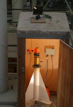


9 1 11/23/2012 9


10 PENTOMINIUM Plot No Marsa Dubai Proposal for Monitoring & Control Survey Services
11 PENTOMINIUM Plot No Marsa Dubai 2 systems / 2 levels proposal (CWCS & SDSM) The environment of the new tower is at least for the first 300 meters unfavourable (obstruction and reflection) to make full use of GNSS (GPS and GLONASS) technology due the signal s obstructions. Leica Geosystems therefore suggests to consider also 2 levels depending of the availability of GNSS signals Blue level Satellite s geometry and availability good GNSS Satellites are rising from East to West and culmulating to the South while never rising from the North Red level Satellite s geometry and availability poor 11

12 12

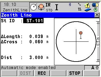
13 GNSS Mission Planning How to cope with such environment? The new Pentominium tower is already surrounded by several high buildings where the average height is about 300 meters which means that below that height GNSS signals can easily be blocked. 13


14 GNSS Mission Planning 14
15 PENTOMINIUM Plot No Marsa Dubai SDSM - RED Level ( h < 300m ) The RED level characteristic is that having no good geometry (GDOP) from GNSS and most probably also multiple reflection (multi-path s) the networked Total Stations will be the major segment. P2 P3 P4 P1 P5 15


16 16


17 Examples of Total Stations located in city centres 17
 will be installed from the ground level to periodically checked the")
18 PENTOMINIUM Plot No Marsa Dubai Core Wall Control Survey System - RED Level Vertical guideline sensors ( Zenith Line onboard application ) will be installed from the ground level to periodically checked the system. The precise inclinometers collocated with the GNSS Antenna s and the 360 reflectors will provide the tilts information. The Leica NIVEL200 will be progressively installed as well along the core wall main axis and networked to provide the complete profile of the structure. 18
19 From ground level up to the height 19

20 Brisbane - Australia 20
21

22 Zenith Line on board application to locate the 22 position of reflectors on the slab level.


23 23
24 0050, , , , , , , , , , , , , , ,Absolute,Vertical,20/10/2011,17:55: , , , , , , , , , , , , , , ,Absolute,Vertical,20/10/2011,17:55: , , , , , , , , , , , , , , ,Absolute,Vertical,20/10/2011,17:55: , , , , , , , , , , , , , , ,Absolute,Vertical,20/10/2011,17:55: , , , , , , , , , , , , , , ,Absolute,Vertical,20/10/2011,17:55: , , , , , , , , , , , , , , ,Relative,Vertical,20/10/2011,17:55: , , , , , , , , , , , , , , ,Relative,Vertical,20/10/2011,17:55:32.8 Word order Description Data type Units 1 Station ID string 2 X double meters 3 Y double meters 4 Z double meters 5 Horizontal Angle first measurement double gons 6 Vertical Angle first measurement double gons 7 Slope Distance first measurement double meters 8 Horizontal Angle current measurement double gons 9 Vertical Angle current measurement double gons 10 Horizontal Angle corrected double gons 11 Vertical Angle corrected double gons 12 Horizontal angle correction double gons 13 Vertical angle correction double gons 14 Compensator inclination length double gons 15 Compensator inclination cross double gons 16 Calculation Mode String Absolute/Relative 17 Plane String Horizontal/Vertical/Per pendicular 18 Measurement date date Day/month/year 19 Measurement time time 24 hours 24
25 Conclusion A Leica TPS with ATR feature and a reflector, can be used as advanced «zenith laser plumet» wich much more key features : Mesure precise vertical distance ( height ) Automatic operation with logging feature and streaming through serial port of the TPS The more we know what s inside our instruments, the more we can derive new and innovative way to answer problems with a solution The initial concept and validation on several cases have been imagine by a Leica exclusive agent in Belgium. Leica Geosystems has adopted at the start an open format attitude that encourages users to develop their own applications. 25
Surveying in the Year 2020
 Surveying in the Year 2020 Johannes Schwarz Leica Geosystems My first toys 2 1 3 Questions Why is a company like Leica Geosystems constantly developing new surveying products and instruments? What surveying
SOFTWARE DEVELOPMENT FOR GEODETIC TOTAL STATIONS IN MATLAB
 SOFTWARE DEVELOPMENT FOR GEODETIC TOTAL STATIONS IN MATLAB Imrich Lipták Slovak University of Technology in Bratislava, Faculty of Civil Engineering, Department of Surveying Radlinského 11, 813 68 Bratislava
Combining Terrestrial and GNSS Technolgies for Geodetic Monitoring. Neil ASHCROFT Leica Geosystems Engineering Segment Manager
 Combining Terrestrial and GNSS Technolgies for Geodetic Monitoring Neil ASHCROFT Leica Geosystems Engineering Segment Manager Structural Monitoring Technolgies Introduction Monitoring Instrumentation Reflectors,
Indian Institute of Technology Kanpur Department of Civil Engineering
 Indian Institute of Technology Kanpur Department of Civil Engineering Inquiry No- CE/JNM/2013-14/R-10 30 December, 2013 Subject: Quotation for supply of Integrated System/Smart System Reflectorless Robotic
MEASURING THE DYNAMIC DEFORMATION OF BRIDGES USING A TOTAL STATION
 Proceedings, 11 th FIG Symposium on Deformation Measurements, Santorini, Greece, 23. MEASURING THE DYNAMIC DEFORMATION OF BRIDGES USING A TOTAL STATION Emily Cosser, Gethin W Roberts, Xiaolin Meng, Alan
14 Technical Data Angle Measurement. Accuracy. Available angular accuracies. Display resolution. Standard deviation Hz, V, ISO
 14 Technical Data 14.1 Angle Measurement Accuracy Available angular accuracies Standard deviation Hz, V, ISO 17123-3 Display resolution ["] [mgon] ["] [ ] [mgon] [mil] 1 0.3 1 0.0001 0.1 0.01 2 0.6 1 0.0001
October 2015 David Grimm, Gerhard Kleemaier, Hans-Martin Zogg Leica Geosystems AG Heerbrugg, Switzerland 2 I White paper - ATRplus
 ATRplus White paper October 2015 David Grimm, Gerhard Kleemaier, Hans-Martin Zogg Leica Geosystems AG Heerbrugg, Switzerland 2 I White paper - ATRplus Abstract The new automatic target recognition ATRplus
The GNSS Active Control Point Concept Get the {dynamic} Reference Points when You Need
 The GNSS Active Control Point Concept Get the {dynamic} Reference Points when You Need Joel van Cranenbroeck Chair of Commission 6 WG 6.2 International Federation of Surveyors (FIG) Belgium, Europa 2 3
LEICA TC2003/TCA2003. High-performance total station for precision surveying to millimetre accuracies with quality certificate
 LEICA TC2003/TCA2003 High-performance total station for precision surveying to millimetre accuracies with quality certificate LEICA TC2003/TCA2003 high-performance total stations The TC2003/TCA2003 high-performance
Long Term Performance Analysis of a New Ground-transceiver Positioning Network (LocataNet) for Structural Deformation Monitoring Applications
 for Structural Deformation Monitoring Applications") Long Term Performance Analysis of a New Ground-transceiver Positioning Network (LocataNet) for Structural Deformation Monitoring Applications Dr. Joel BARNES, Australia, Mr. Joel VAN CRANENBROECK, Belgium,
Long Term Performance Analysis of a New Ground-transceiver Positioning Network (LocataNet) for Structural Deformation Monitoring Applications Dr. Joel BARNES, Australia, Mr. Joel VAN CRANENBROECK, Belgium,
STRUCTURAL BRIDGE HEALTH MONITORING WITH GLONASS AND GPS THE YEONG-JONG BRIDGE IN SOUTH KOREA
 Joël VAN CRANENBROECK Leica Geosystems AG, Switzerland, joel.vancranenbroeck@leica-geosystems.com STRUCTURAL BRIDGE HEALTH MONITORING WITH GLONASS AND GPS THE YEONG-JONG BRIDGE IN SOUTH KOREA Key words:
Absolute Antenna Calibration
 Absolute Antenna Calibration (Characteristics of Antenna Type) Method Geo++ GNPCV Real Time Calibration Antenna Data Manufacturer : CHC Shanghai HuaCe Navigation Technology Ltd. Antenna Type : i80 GNSS
Innovation and Experience in GNSS Bridge Real Time 3D- Monitoring System
 Innovation and Experience in GNSS Bridge Real Time 3D- Monitoring System Joël van Cranenbroeck, Managing Director CGEOS Creative GeoSensing sprl-s Rue du Tienne de Mont, 11 5530 MONT, Belgium Transportation
Crawler Tractors PR 714 PR 764. Product information. Grade control systems
 Crawler Tractors PR 714 PR 764 Product information Grade control systems Grade Control Systems for Crawler Tractors To be successful in spite of ever-increasing time and cost pressures, construction machinery
A New Geodetic Network Design for Hydro Power Plant
 A New Geodetic Network Design for Hydro Power Plant Joël VAN CRANENBROECK, Belgium Andrey BALAN, Ukraine Marco DI MAURO, Italy Key words: Structural Health Analysis, GLONASS, GPS, Centralized Processing,
Experience of Using Total Station and GNSS Technologies for Tall Building Construction Monitoring
 Experience of Using Total Station and GNSS Technologies for Tall Building Construction Monitoring Irineu da Silva 1(&), Wernher Ibañez 2, and Guilherme Poleszuk 1 1 Department of Transportation Engineering,
Establishing a Geodetic Monitoring System for Gotvand Dam
 1 Establishing a Geodetic Monitoring System for Gotvand Dam Reza Esmaeili, Iran Joel Vancranenbroeck, Belgium Key words: geodetic monitoring system, dam monitoring SUMMARY Geodetic monitoring is one of
A New Geodetic Network Design for Hydro Power Plants
 Kaniv HPP Dniprodzerzhynsk HPP Dnipro HPP Dnister HPP A New Geodetic Network Design for Hydro Power Plants Joël van Cranenbroeck International Projects & Business Technology Manager Leica Geosystems AG
Advances in GNSS-RTK for Structural Deformation Monitoring in Regions of High Ionospheric Activity
 Advances in GNSS-RTK for Structural Deformation Monitoring in Regions of High Ionospheric Activity Chris RIZOS, Australia, Joël van CRANENBROECK, Belgium, Vincent LUI, Hong Kong, PR China Key words: GNSS,
SPAN Technology System Characteristics and Performance
 SPAN Technology System Characteristics and Performance NovAtel Inc. ABSTRACT The addition of inertial technology to a GPS system provides multiple benefits, including the availability of attitude output
Monitoring Lecture ETH Zürich, Michael Rutschmann
 Monitoring Lecture 5.11.2008 ETH Zürich, Michael Rutschmann Monitoring lecture Contents 1. Monitoring System Intro 2. Different Setup of Monitoring Systems 3. GeoMoS (Monitor and Analyzer) 4. Setup of
Leica SmartStation Total Station with integrated GPS
 Leica SmartStation Total Station with integrated GPS Leica SmartStation Total station with integrated GPS New revolutionary surveying system. World s first, TPS and GPS perfectly combined. High performance
TheoDist FTD 05 REFLECTORLESS CONSTRUCTION TACHYMETER
 TheoDist FTD 05 REFLECTORLESS CONSTRUCTION TACHYMETER geo-fennel TheoDist The geo-fennel TheoDist is a new simple and easy to use device. The TheoDist is a combination of an Electronic Theodolite and a
Leica Viva Image Assisted Surveying & Image Notes
 Leica Viva Image Assisted Surveying & Image Notes Contents 1. Introduction 3. Image Notes 4. Availability 5. Summary 1. Introduction Image Assisted Surveying Camera live view of what the total station
Dimensional Survey Company
 Dimensional Survey Company AnkoBluepix was founded in 2016 by experienced engineers, each a specialist within different segments of the survey business. Even though AnkoBluepix is a young company Our Mother
SURVEYING 1 CE 215 CHAPTER -3-
 Civil Engineering Department SURVEYING 1 CE 215 CHAPTER -3- PROFILE AND CROSS SECTION LEVELING 1 2 1 3 4 2 5 6 3 7 8 4 9 10 5 11 12 6 13 14 7 15 16 8 17 18 9 19 20 10 21 22 11 23 24 12 25 26 13 27 28 14
GeoMax Total Station Zoom20 Series
 GeoMax Total Station Zoom20 Series GeoMax About Us GeoMax is an internationally nology group with strong mar- The close cooperation within active company developing, ket positions within measure- the Hexagon
Leica GRX1200 Series High Performance GNSS Reference Receivers
 Leica GRX1200 Series High Performance GNSS Reference Receivers Leica GRX1200 Series For permanent reference stations The Leica GRX1200 Series, part of Leica s new System 1200, is designed specifically
Leica SmartStation Total Station with integrated GNSS
 Leica SmartStation Total Station with integrated GNSS Leica SmartStation Total station with integrated GNSS New revolutionary surveying system. World s first, TPS and GNSS perfectly combined. High performance
EXPERIMENTAL RESULTS OF LEX CORRECTIONS USING FARMING MACHINE
 Sixth Meeting of the International Committee on Global Navigation Satellite Systems (ICG) EXPERIMENTAL RESULTS OF LEX CORRECTIONS USING FARMING MACHINE Masayuki Kanzaki Hitachi Zosen Corporation Prof.
Dimensional Survey Company
 Dimensional Survey Company Services Anko Bluepix was founded in 2016 by experienced engineers, each a specialist within different segments of the survey business. Even though Anko Bluepix is a young company
LAB 1 METHODS FOR LOCATING YOUR FIELD DATA IN GEOGRAPHIC SPACE. Geog 315 / ENSP 428
 LAB 1 METHODS FOR LOCATING YOUR FIELD DATA IN GEOGRAPHIC SPACE Geog 315 / ENSP 428 Lab 1 Schedule Introduction to bio-physical field data collection (8:00-8:20am) Locating your data on the earth: NAVSTAR
Locata: A New Constellation for High Accuracy Outdoor & Indoor Positioning
 Locata: A New Constellation for High Accuracy Outdoor & Indoor Positioning Chris Rizos, Yong Li, Nonie Politi School of Surveying & Spatial Information Systems University of New South Wales, Sydney, Australia
Chapter 8. Electronic Survey Measurement. Dr. Maher A. El-Hallaq Lecturer of Surveying The Islamic University of Gaza
 Chapter 8 Electronic Survey Measurement Dr. Maher A. El-Hallaq Lecturer of Surveying The Islamic University of Gaza Contents Introduction. Parts of a total station. Handling a total station. Total station
Radiation characteristics of a dipole antenna in free space
 Department of Electrical and Electronic Engineering (EEE), Bangladesh University of Engineering and Technology (BUET). EEE 434: Microwave Engineering Laboratory Experiment No.: A1 Radiation characteristics
Leica GRX1200+ Series High Performance GNSS Reference Receivers
 Leica GRX1200+ Series High Performance GNSS Reference Receivers Leica GRX1200+ Series For permanent reference stations The Leica GRX1200+ Series, part of Leica's future proof System 1200, is designed specifically
NovAtel s. Performance Analysis October Abstract. SPAN on OEM6. SPAN on OEM6. Enhancements
 NovAtel s SPAN on OEM6 Performance Analysis October 2012 Abstract SPAN, NovAtel s GNSS/INS solution, is now available on the OEM6 receiver platform. In addition to rapid GNSS signal reacquisition performance,
Webinar. 9 things you should know about centimeter-level GNSS accuracy
 Webinar 9 things you should know about centimeter-level GNSS accuracy Webinar agenda 9 things you should know about centimeter-level GNSS accuracy 1. High precision GNSS challenges 2. u-blox F9 technology
ProMark 3 RTK. White Paper
 ProMark 3 RTK White Paper Table of Contents 1. Introduction... 1 2. ProMark3 RTK Operational Environment... 2 3. BLADE TM : A Unique Magellan Technology for Quicker Convergence... 3 4. ProMark3 RTK Fixed
TheoDist Series FTD 05 / FTD 02. Compact Total Station
 TheoDist Series FTD 05 / FTD 02 Compact Total Station geo-fennel TheoDist Compact Total Stations The geo-fennel TheoDist Series is an instrument designed to be easy to use and quick to set up on any construction
Testing RTK GPS Horizontal Positioning Accuracy within an Urban Area
 Testing RTK GPS Horizontal Positioning Accuracy within an Urban Area Ismat M Elhassan* Civil Engineering Department, King Saud University, Surveying Engineering Program, Kingdom of Saudi Arabia Research
3-DEMON MONITORING PLATFORM: EXAMPLES OF APPLICATIONS IN STRUCTURAL AND GEOTECHNICAL MONITORING PROJECTS
 3-DEMON MONITORING PLATFORM: EXAMPLES OF APPLICATIONS IN STRUCTURAL AND GEOTECHNICAL MONITORING PROJECTS Luca MANETTI, Daniele INAUDI and Branko GLISIC Smartec SA, Switzerland Abstract: The 3DeMoN (3-Dimentional
Leica MNS1200 GNSS Series Toughest GNSS solution for toughest sites
 Leica MNS1200 GNSS Series Toughest GNSS solution for toughest sites >Fast >Smart >Integrated Leica MNS1200 GNSS Series Robust GNSS machine navigation solution The Leica MNS1200 GNSS (Global Navigation
Digital Land Surveying Dr. Jayanta Kumar Ghosh Department of Civil Engineering Indian Institute of Technology, Roorkee
 Digital Land Surveying Dr. Jayanta Kumar Ghosh Department of Civil Engineering Indian Institute of Technology, Roorkee Lecture 21 Measurement of Distance Welcome students, this is the 21st lecture on digital
Introduction to Total Station and GPS
 Introduction to Total Station and GPS Dr. P. NANJUNDASWAMY Professor of Civil Engineering J S S Science and Technology University S J College of Engineering Mysuru 570 006 Introduction History GPS Overview
Using SurvCE s Live Digital Level (LDL) Feature Updated: Feb 20, 2015
 Feature Updated: Feb 20, 2015") Using SurvCE s Live Digital Level (LDL) Feature Updated: Feb 20, 2015 OVERVIEW Version 4.0 of Carlson Software s SurvCE data collection software now includes a Live Digital Level (LDL) or electronic bubble
Using SurvCE s Live Digital Level (LDL) Feature Updated: Feb 20, 2015 OVERVIEW Version 4.0 of Carlson Software s SurvCE data collection software now includes a Live Digital Level (LDL) or electronic bubble
Suveying Lectures for CE 498
 Suveying Lectures for CE 498 SURVEYING CLASSIFICATIONS Surveying work can be classified as follows: 1- Preliminary Surveying In this surveying the detailed data are collected by determining its locations
HALS-H1 Ground Surveillance & Targeting Helicopter
 ARATOS-SWISS Homeland Security AG & SMA PROGRESS, LLC HALS-H1 Ground Surveillance & Targeting Helicopter Defense, Emergency, Homeland Security (Border Patrol, Pipeline Monitoring)... Automatic detection
GeoMax GNSS Zenith10 & Zenith20 Series
 GeoMax GNSS Zenith10 & Zenith20 Series GeoMax About Us At GeoMax we provide a com- group with strong market At GeoMax, we concentrate on prehensive portfolio of inte- positions within measurement providing
Camera Calibration Certificate No: DMC III 27542
 Calibration DMC III Camera Calibration Certificate No: DMC III 27542 For Peregrine Aerial Surveys, Inc. #201 1255 Townline Road Abbotsford, B.C. V2T 6E1 Canada Calib_DMCIII_27542.docx Document Version
SPAN Tightly Coupled GNSS+INS Technology Performance for Exceptional 3D, Continuous Position, Velocity & Attitude
 SPAN Tightly Coupled GNSSINS Technology Performance for Exceptional 3D, Continuous Position, Velocity & Attitude SPAN Technology NOVATEL S SPAN TECHNOLOGY PROVIDES CONTINUOUS 3D POSITIONING, VELOCITY AND
SURVEYORS BOARD OF QUEENSLAND. RTK GNSS for Cadastral Surveys. Guideline
 SURVEYORS BOARD OF QUEENSLAND RTK GNSS for Cadastral Surveys Guideline 30 November 2012 RTK GNSS for Cadastral Surveys General The Surveyors Board of Queensland has recently become aware of some issues
Range Sensing strategies
 Range Sensing strategies Active range sensors Ultrasound Laser range sensor Slides adopted from Siegwart and Nourbakhsh 4.1.6 Range Sensors (time of flight) (1) Large range distance measurement -> called
A LARGE COMBINATION HORIZONTAL AND VERTICAL NEAR FIELD MEASUREMENT FACILITY FOR SATELLITE ANTENNA CHARACTERIZATION
 A LARGE COMBINATION HORIZONTAL AND VERTICAL NEAR FIELD MEASUREMENT FACILITY FOR SATELLITE ANTENNA CHARACTERIZATION John Demas Nearfield Systems Inc. 1330 E. 223rd Street Bldg. 524 Carson, CA 90745 USA
Other Space Geodetic Techniques. E. Calais Purdue University - EAS Department Civil 3273
 Other Space Geodetic Techniques E. Calais Purdue University - EAS Department Civil 3273 ecalais@purdue.edu Satellite Laser Ranging = SLR Measurement of distance (=range) between a ground station and a
IBIS range. GeoRadar Division. GeoRadar Division. Static and Dynamic Monitoring of Civil Engineering Structures by Microwave Interferometry
 Static and Dynamic Monitoring of Civil Engineering Structures by Microwave Interferometry Garry Spencer and Mark Bell 1 PRODUCTS IBIS range APPLICATIONS IBIS - FL LANDSLIDE & DAM MONITORING IBIS - FM SLOPE
Equipment List For GNSS Networks and Reference Stations
 Equipment List For GNSS Networks and Reference Stations GNSS Reference Station with GPS Spider Software Essential Items: For Data logging only: For transmitting RTK/DGPS data: a - Power supply l - Cable
Shared Use of DGPS for DP and Survey Operations
 Gabriel Delgado-Saldivar The Use of DP-Assisted FPSOs for Offshore Well Testing Services DYNAMIC POSITIONING CONFERENCE October 17-18, 2006 Sensors Shared Use of DGPS for Dr. David Russell Subsea 7, Scotland
PRINCIPLES AND FUNCTIONING OF GPS/ DGPS /ETS ER A. K. ATABUDHI, ORSAC
 PRINCIPLES AND FUNCTIONING OF GPS/ DGPS /ETS ER A. K. ATABUDHI, ORSAC GPS GPS, which stands for Global Positioning System, is the only system today able to show you your exact position on the Earth anytime,
CHAPTER 7 Total Station Surveying. CE 316 March 2012
 CHAPTER 7 Total Station Surveying CE 316 March 2012 249 7.1 Introduction Total station surveying - defined as the use of electronic survey equipment used to perform horizontal and vertical measurements
Other Space Geodetic Techniques. E. Calais Purdue University - EAS Department Civil 3273
 Other Space Geodetic Techniques E. Calais Purdue University - EAS Department Civil 3273 ecalais@purdue.edu Satellite Laser Ranging Measurement of distance (=range) between a ground station and a satellite
The Potential of a Ground Based Transceivers Network for Water Dam Deformation Monitoring
 The Potential of a Ground Based Transceivers Network for Water Dam Deformation Monitoring J.B Barnes School of Surveying and Spatial Information Systems, University of New South Wales, Sydney, Australia
Assessment of high-rate GPS using a single-axis shake table
 Assessment of high-rate GPS using a single-axis shake table S. Häberling, M. Rothacher, A. Geiger Institute of Geodesy and Photogrammetry, ETH Zurich Introduction Project: Study the applicability of high-rate
BG-Map Mapping the world one plant at a time
 BG-Map Mapping the world one plant at a time Total Station Interface Users Manual Total Station Interface version 5.8 Copyright 1992-2015 Glicksman Associates, Inc. All rights reserved. No part of this
TPS - System Version 2.2 English QUICK START 1000Z01
 QUICK START TPS - System 1000 1000Z01 Version 2.2 English The quick way to start with TPS-System 1000. 2 ð ð 1000QS01 1000QS02 1000QS19 To use the equipment in the permitted manner, please refer to the
Module-4 Lecture-2 Perpendicularity measurement. (Refer Slide Time: 00:13)
") Metrology Prof. Dr. Kanakuppi Sadashivappa Department of Industrial and Production Engineering Bapuji Institute of Engineering and Technology-Davangere Module-4 Lecture-2 Perpendicularity measurement (Refer
Metrology Prof. Dr. Kanakuppi Sadashivappa Department of Industrial and Production Engineering Bapuji Institute of Engineering and Technology-Davangere Module-4 Lecture-2 Perpendicularity measurement (Refer
ATLANS-C. mobile mapping position and orientation solution
 mobile mapping position and orientation solution mobile mapping position and orientation solution THE SMALLEST ATLANS-C is a high performance all-in-one position and orientation solution for both land
About compliance of GLONASS S/C retroreflectors system with the requirements of International Laser Ranging Service standard
 FEDERAL SPACE AGENCY FGUP «Science-Research Institute for Precise Instrument Engineering» About compliance of GLONASS S/C retroreflectors system with the requirements of International Laser Ranging Service
Advanced Least Squares Adjustments for Post Processed GPS
 Advanced Least Squares Adjustments for Post Processed GPS 2018 Fall Conference October 18, 2018 College park, Maryland Instructor: Maser Consulting PA Independent Baselines The observations for GPS receivers
Optics and optical instruments Field procedures for testing geodetic and surveying instruments. Part 8:
 Provläsningsexemplar / Preview INTERNATIONAL STANDARD ISO 17123-8 Second edition 2015-06-15 Optics and optical instruments Field procedures for testing geodetic and surveying instruments Part 8: GNSS field
Resection. We can measure direction in the real world! Lecture 10: Position Determination. Resection Example: Isola, Slovenia. Professor Keith Clarke
 Geography 12: Maps and Spatial Reasoning Lecture 10: Position Determination We can measure direction in the real world! Professor Keith Clarke Resection Resection Example: Isola, Slovenia Back azimuth
Field Testing of Vision Based Macadamia Yield Monitoring
 Field Testing of Vision Based Macadamia Yield Monitoring Mark Dunn 1, John Billingsley 1 and David Bell 2 1 National Centre for Engineering in Agriculture Faculty of Engineering and Surveying University
ALIGNMENT METHODS APPLIED TO THE LEP MAGNET MEASUREMENTS. J. Billan, G. Brun, K. N. Henrichsen, P. Legrand, 0. Pagano, P. Rohmig and L. Walckiers.
 295 ALIGNMENT METHODS APPLIED TO THE LEP MAGNET MEASUREMENTS J. Billan, G. Brun, K. N. Henrichsen, P. Legrand, 0. Pagano, P. Rohmig and L. Walckiers. CERN, CH-1211 Geneva 23, Switzerland Introduction Electromagnets
Automated Quality Control of Global Navigation Satellite System (GNSS) Data
 Data") P-315 Automated Quality Control of Global Navigation Satellite System (GNSS) Data S.Senthil Kumar* & Arun Kumar Chauhan, ONGC Summary Global Navigation Satellite System (GNSS), includes GPS, GLONASS and
P-315 Automated Quality Control of Global Navigation Satellite System (GNSS) Data S.Senthil Kumar* & Arun Kumar Chauhan, ONGC Summary Global Navigation Satellite System (GNSS), includes GPS, GLONASS and
Helicopter Aerial Laser Ranging
 Helicopter Aerial Laser Ranging Håkan Sterner TopEye AB P.O.Box 1017, SE-551 11 Jönköping, Sweden 1 Introduction Measuring distances with light has been used for terrestrial surveys since the fifties.
CONCEPT OF INTEGRATED CONTROL SYSTEM FOR MONITORING GEOMETRIC CHANGES OF THE TEMPORARY BRIDGE CROSSINGS
 CONCEPT OF INTEGRATED CONTROL SYSTEM FOR MONITORING GEOMETRIC CHANGES OF THE TEMPORARY BRIDGE CROSSINGS A. Bartnicki 1), J. Bogusz 2), G. Nykiel 2), M. Szołucha 2), M. Wrona 2) 1) Faculty of Mechanical
Including GNSS Based Heading in Inertial Aided GNSS DP Reference System
 Author s Name Name of the Paper Session DYNAMIC POSITIONING CONFERENCE October 9-10, 2012 Sensors II SESSION Including GNSS Based Heading in Inertial Aided GNSS DP Reference System By Arne Rinnan, Nina
This firmware is protected and can only be loaded onto instruments with valid firmware (software) Maintenance date.
 Maintenance date.") Products: TS30, TM30, TPS1200, GPS1200, RX1250 From: System 1200 Product Management Date: January 2011 DVD ROM: Leica SmartWorx DVD (Art. No. 755806) Version: SmartWorx v8.10 Download: These Release Notes
Products: TS30, TM30, TPS1200, GPS1200, RX1250 From: System 1200 Product Management Date: January 2011 DVD ROM: Leica SmartWorx DVD (Art. No. 755806) Version: SmartWorx v8.10 Download: These Release Notes
Quick Start. Tersus GNSS Center. Configuration Tools for Tersus GNSS RTK Systems.
 Quick Start Tersus GNSS Center Configuration Tools for Tersus GNSS RTK Systems www.tersus-gnss.com July, 2016 1. Quick Start Guide of Tersus GNSS Center This quick start guide provides the basic information
Viva TPS. TS11/15 Total Stations Connect the CS Controller and TS15 with the RH15. October Summary
 Viva TPS October 2010 TS11/15 Total Stations Connect the CS Controller and TS15 with the RH15 Summary This guide will show how to connect the TS15 instrument and CS controller for remote operation. This
al T TD ) ime D Faamily Products The RTD Family of products offers a full suite of highprecision GPS sensor positioning and navigation solutions for:
 ime D Faamily Products The RTD Family of products offers a full suite of highprecision GPS sensor positioning and navigation solutions for:") Reeal ynnamics al T amics (R TD ) ime D RTD) Time Dy Faamily mily ooff P roducts Products The RTD Family of products offers a full suite of highprecision GPS sensor positioning and navigation solutions
Reeal ynnamics al T amics (R TD ) ime D RTD) Time Dy Faamily mily ooff P roducts Products The RTD Family of products offers a full suite of highprecision GPS sensor positioning and navigation solutions
Use of ground based radar to monitor the effect of increased axle loading on rail bridges. Evgeny Shilov. IDS GeoRadar
 Use of ground based radar to monitor the effect of increased axle loading on rail bridges aa Evgeny Shilov IDS GeoRadar Background of Techniques All rights reserved to IDS GeoRadar 2 Radar technology Radar
ENHANCEMENTS IN UAV FLIGHT CONTROL AND SENSOR ORIENTATION
 Heinz Jürgen Przybilla Manfred Bäumker, Alexander Zurhorst ENHANCEMENTS IN UAV FLIGHT CONTROL AND SENSOR ORIENTATION Content Introduction Precise Positioning GNSS sensors and software Inertial and augmentation
REAL-TIME MONITORING OF HIGHWAY BRIDGES USING "DREAMS"
 Proceedings, 11 th FIG Symposium on Deformation Measurements, Santorini, Greece, 2003. REAL-TIME MONITORING OF HIGHWAY BRIDGES USING "DREAMS" Günter W. Hein and Bernhard Riedl Institute of Geodesy and
Leica icon gps 80 Equipment List
 Leica icon gps 80 Equipment List Table of Contents icon gps 80 Machine Control GNSS receiver 3 1 icon gps 80 Machine Control GNSS receiver 3 2 Additional icon gps 80 Receiver Options 4 3 Slot in Radios
Series SRX SURVEYING INSTRUMENTS QUICK START GUIDE 1 PREPARATION 2. MEASUREMENT SETTINGS. Auto Tracking PROCEDURE
 SURVEYING INSTRUMENTS Series SRX QUICK START GUIDE This guide explains settings and procedures for standard measurement using the SRX as an element of the On-demand Remote Control System (RC-PR3). For
CHC MINING DEFORMATION MONITORING SOLUTION
 CHC MINING DEFORMATION MONITORING SOLUTION Safety is first in mining. CHC offers solutions designed to improve safety for personnel on the ground and in the cab with 24/7 precision positioning for automatic
Global Navigation Satellite System for IE 5000
 Global Navigation Satellite System for IE 5000 Configuring GNSS 2 Information About GNSS 2 Guidelines and Limitations 4 Default Settings 4 Configuring GNSS 5 Configuring GNSS as Time Source for PTP 6 Verifying
Experiences with Fugro's Real Time GPS/GLONASS Orbit/Clock Decimeter Level Precise Positioning System
 Return to Session Directory DYNAMIC POSITIONING CONFERENCE October 13-14, 2009 Sensors Experiences with Fugro's Real Time GPS/GLONASS Orbit/Clock Decimeter Level Precise Positioning System Ole Ørpen and
High Gain Advanced GPS Receiver
 High Gain Advanced GPS Receiver NAVSYS Corporation 14960 Woodcarver Road, Colorado Springs, CO 80921 Introduction The NAVSYS High Gain Advanced GPS Receiver (HAGR) is a digital beam steering receiver designed
Version 4.0 English. Leica TPS400 Series User Manual
 Version 4.0 English Leica TPS400 Series User Manual Electronical Total Station Congratulations on your purchase of a new Leica Geosystems Total Station. This manual contains important safety directions
THE MONITORING OF BRIDGE MOVEMENTS USING GPS AND PSEUDOLITES
 Proceedings, 11 th FIG Symposium on Deformation Measurements, Santorini, Greece, 23. THE MONITORING OF BRIDGE MOVEMENTS USING GPS AND PSEUDOLITES Joel Barnes 1, Chris Rizos 1, Jinling Wang 1 Xiaolin Meng
Terrestrial Laser Scanning. 3D Laser Scanner with Real-Time Registration & Processing. Preliminary Data Sheet
 VZ 4 3D Laser Scanner with Real-Time Registration & Processing RIEGL VZ-4i new, innovative processing architecture for data acquisition and simultaneous geo-referencing, filtering and analysis in real-time
3. Product Instruction. 3.1 External Components
 INDEX INDEX... 0 1. Preface... 1 2. Precautions... 2 3. Product Instruction... 3 3.1 External Components... 3 3.2 Display And Keypad... 4 4. Specifications Check And Adjustment... 5 4.1 Plat Vial... 5
33 BY 16 NEAR-FIELD MEASUREMENT SYSTEM
 33 BY 16 NEAR-FIELD MEASUREMENT SYSTEM ABSTRACT Nearfield Systems Inc. (NSI) has delivered the world s largest vertical near-field measurement system. With a 30m by 16m scan area and a frequency range
Real-Time Processing Strategeis - System 500
 30 40 0 Real-Time rocessing Strategeis - System 00 New Ambiguity Resolution Strategies Improved Reliability in Difficult Environments Shortened Ambiguity Resolution Times Low Latency Results Christian
ABSTRACT: Three types of portable units with GNSS raw data recording capability are assessed to determine static and kinematic position accuracy
 ABSTRACT: Three types of portable units with GNSS raw data recording capability are assessed to determine static and kinematic position accuracy under various environments using alternatively their internal
Antenna Selection for Bridge Deformation Monitoring Comparison of Multipath Mitigation Characteristics for Three Types of Antennas
 Antenna Selection for Bridge Deformation Monitoring Comparison of Multipath Mitigation Characteristics for Three Types of Antennas Oluropo OGUNDIPE, United Kingdom and Gethin Roberts, China, PR Key words:
Next Generation Positioning Infrastructure
 Next Generation Positioning Infrastructure The GNSS Network in the 21 st Century Joel VAN CRANENBROECK & Partners Beyond East & West GeoSensing Community 1 INFRASTRUCTURE "The installations that form the
Exercise 2-6. Target Bearing Estimation EXERCISE OBJECTIVE
 Exercise 2-6 EXERCISE OBJECTIVE When you have completed this exercise, you will be able to evaluate the position of the target relative to a selected beam using the A-scope display. You will be able to