Services of the International Association of Geodesy and IGS - Global Geodetic Observing System Links & References
|
|
|
- Felix Elliott
- 6 years ago
- Views:
Transcription


1 Services of the International Association of Geodesy and IGS - Global Geodetic Observing System Links & References Ruth E. Neilan Director, IGS Central Bureau; Vice-Chair, GGOS FIG Rome 2012, Reference Frames in Practice May 5
2 Outline Some cool historic images Satellite Geodesy IAG, IGS and Global Geodetic Observing System (GGOS) context IGS Organization Products Web surfing and resources Prime Focus: IGS M-GEX Multi-GNSS Global Experiment IGS Real Time Project IGS and ICG Activities 10 years - AFREF, example of challenges for regional references GGOS & other initiatives MEGA Meta-data Exchange for Geodetic Applications Nic Donnelly

3 Positioning, geodesy, surveying, astronomic observations Peter Apian s Geographia, circa 1533

4 Navigation & Timing Harrison I, First marine chronometer, ~1700


5 19,000 Satellites in Earth Orbit All GNSS Artist view - GPS World

6
7 IAG, GGOS & IGS The International Association of Geodesy (IAG) represents the geosciences associated with the geometric & gravimetric aspects of the dynamic Earth. IAG is part of International Union of Geodesy and Geophysics (IUGG) & International Council for Science (ICSU). IAG is the oldest of the international scientific associations 150 years old in 2012, celebration 2013 (Potsdam) IAG s Global Geodetic Observing System (GGOS) integrates all IAG Services to coordinate geodetic measurements, analysis and product generation to support science and society. The IGS coordinates GNSS tracking, data analysis and product generation to support GGOS and other users Key to the IGS approach: sharing investments and operational costs by pooling the resources of many (> 200) organisations in over 100 countries to maintain an independent ground tracking network and generate high accuracy products voluntary federation, reliability through redundancy, data & products openly available to all users. IGS contributes the GNSS global contribution to the International Terrestrial Reference Frame (ITRF) where all regional reference frames are connected

8 Space Geodesy Today Observations, Combination and Integration Ensure the consistency and improve the accuracy of the resulting geodetic products Complementary use of the individual techniques to strengthen the solutions Benefits from observing instruments co-located at the same site/satellite Distinguish genuine geodetic/geophysical signals from techniquespecific systematic biases Crucial to get a more detailed view and understanding of the complexity of the "System Earth" and its geophysical processes.
9 International GNSS Service - IGS

10 Perspective on Our World of Multi-GNSS GPS, GLONASS, Compass, Galileo, SBAS - more better Early lessons with GPS show that in-depth GPS/GNSS studies in any region require a global infrastructure - this is the perspective that drove the development of an international federation - IGS. (Seeded from CASA-Uno 88 & IAG CSTG) Driven by understanding our planet Science is continent-blind GNSS applications for top-end science & technology in regional areas, must have a global construct, network, a global reference frame Improving Earth observing with GNSS can provide early warning for natural disasters and mitigate their effects: Tsunamis, sea level rise, earthquakes, volcanoes Weather, Space weather, climate change, Real-time responses
11 IGS Mission The International GNSS Service provides the highest-quality GNSS data, products, and services in support of the Earth observations and research, positioning, navigation and timing, the terrestrial reference frame, Earth rotation, and other applications that benefit society. * IGS is a key component of the Global Geodetic Observing System GGOS *From IGS Strategic Plan
12 International GNSS Service (IGS) Potential of GPS for Geodesy, Surveying and Geodynamics was recognized in the late 1980 s. Start of IGS Test Campaign in June 1992, Official IAG Service since Renamed International GNSS Service in March 2005: GPS + GLONASS Products: Precise Orbits Clock corrections & timescale Station positions and velocities >ITRF Troposphere parameters Ionosphere maps Earth orientation parameters GPS and GLONASS tracking & products. New Multi- GNSS Global Experiment IGS global tracking network 1993


13 Scientific Drivers Extending the Reference Frame to Multiple Applications Illuminating the Earth with GPS IONOSPHERE OCEANS SOLID EARTH ATMOSPHERE High resolution 3D ionospheric imaging Ionospheric structure & dynamics Iono/thermo/atmospheric interactions Onset, evolution & prediction of Space storms Significant wave height Ocean geoid and global circulation Short-term eddy scale circulation Earth rotation Polar motion Shape and deformation of Earth Location & motion of the geocenter Gross mass distribution Climate change & weather modeling Global profiles of atmos density, pressure, temp, and geopotential height Structure, evolution of the tropopause Atmospheric winds, waves & turbulence TIDs and global energy transport Surface winds and sea state Structure, evolution of the deep interior Tropospheric water vapor distribution Precise ion cal for OD, SAR, altimetry Precise global reference frame Structure & evolution of surface/atmosphere boundary layer


 Data Centers Global Data Centers Regional Data")

 Bureau International des Poids et Mesures (BIPM) International Council for Science/Word Data Systems (ICS/WDS) United")
14 IGS Associate Members External Interfaces IAG/GGOS IERS BIPM ICSU/WDS UNOOSA/ICG Governing Board Oversight Committees of the GB Executive Committee Strategic Planning Committee Elections Committees Infrastructure Committee Associate Member Committee Pilot Projects and Working Groups Product Coordinators Reference Frame Clock Products Analysis Coordinator Central Bureau Executive Management Network Coordination Information Portal Support Organizations IGS Institute UNAVCO Antenna WG Bias & Calibration WG Clock Product WG Data Centers WG GNSS WG Ionosphere WG Real-time WG & PP Reference Frame WG Space Vehicle Orbit Dynamics WG Troposphere WG Tide Gauge PP Analysis Centers Global Network ACs Global Network AACs Regional Network AACs Other AACs (Ionosphere, Real-Time) Data Centers Global Data Centers Regional Data Centers Operational Data Centers Project Data Centers Tracking Stations Reference Frame Stations Multi GNSS Stations Real-time Stations Application Stations (e.g., Tide Gauge) International Association for Geodesy/Global Geodetic Observing System (IAG/GGOS) International Earth Rotation and Reference System Service (IERS) Bureau International des Poids et Mesures (BIPM) International Council for Science/Word Data Systems (ICS/WDS) United Nations Office for Outer Space Affairs/International Committee on GNSS (UNOOSA/ICG) Analysis Center (AC) Associate Analysis Center (AAC)


15 International GNSS Service Formerly the International GPS Service Many satellite missions, Earth science missions, multidisciplinary applications, National Mapping Agencies and Universities rely upon the openly-available IGS products, such as ephemerides and coordinate time series. The IGS is a voluntary federation of more than 200 worldwide agencies in more than 100 countries that pool resources and permanent GPS station data to generate precise GPS products with open data policy. Over 400 permanent tracking stations operated by more than 100 worldwide agencies comprise the IGS network. Currently the IGS supports two GNSS: GPS and the Russian GLONASS. IGS plans to include Galileo, Compass and QZSS once available. GPS Applications in IGS Projects & Working Groups IGS products are formed by combining independent results from each of several Analysis Centers. Improvements in signals and computations have brought the centers consistency in the Final GPS satellite orbit calculation to ~ 2cm. Graph courtesy Analysis Coordinator J. Ray, NOAA, NGS IGS Reference Frame Timing and Precise Clocks Ionosphere WG Antenna Calibration WG Bias and Calibration WG Troposphere WG Sea Level - TIGA Project Real-Time WG & Project Data Center WG GNSS WG Orbit Modeling WG

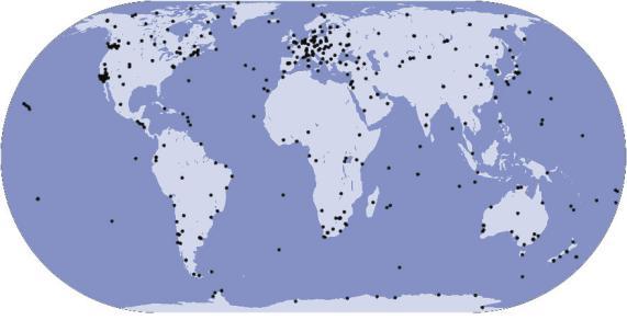
16 IGS Tracking Network Over 380 active global tracking stations

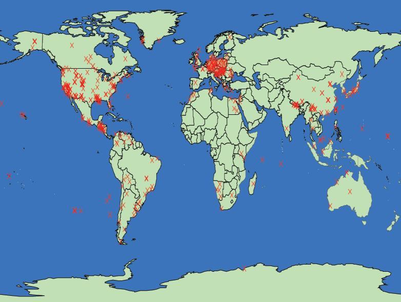
17 IGS Multi-GNSS Network: GLONASS + GPS

18 The Global Picture: Global Velocity Field ITRF2008 GPS Core networks Bruyninx et al., 2011, IAG WG on Regional Dense Velocity Fields

19 igs.org

20 IGS Website Statistics March 2012

21

22

23 IGS Data Formats Resource

24 IGS Mail List Archives
25 IGS Multi-GNSS Global Experiment M-GEX Motivation Goal New and modernized systems and signals upcoming or available Receivers have multi-gnss capabilities IGS must prepare for incorporation of new GNSS Experiment to operate an expanded network of new receivers capable of tracking new signals in addition to GPS & GLONASS Support & coordinate with Multi-GNSS Asia (MGA) activities Tasks Set-up tracking network of Multi-GNSS equipment Make tracking data publicly available Experiment with data flow and signals, qualify equipment, signals,... Upgrade IGS network to Multi-GNSS Generate Multi-GNSS products
26 M-GEX More than 100 GNSS satellites will be available in the near future Not only more satellites, but also more and better signals, better clocks also Real-time stations Heterogeneous system of satellite systems and heterogeneous user equipment interoperability, compatibility, interchangeability IGS is preparing for incorporation of new systems and signals into routine operations M-GEX Call for Participation Experiment from February through August 2012, continuing observations encouraged: Seeking groups for tracking, archiving, analyzing of new signals Interested groups can join at anytime First results at IGS Workshop in Olsztyn, Poland, July 2012

27
28 IGS Real-Time Pilot Project Real-time product generation is part of IGS Strategic Plan Infrastructure More than 120 active real-time stations Close link to RTCM Joint WG established Analysis The Radio Technical Commission for Maritime Services 6 real-time analysis centers Real time clock combination Future Include new systems and signals M-GEX Real-time service To be announced soon Satellite clock corrections, orbits, ionosphere corrections Zero-difference Ambiguity resolution

29 IGS Real Time Network March 2012 ~160 Stations - soon to become openly available!

30 Real-Time Clock Product Table

31 Real-Time Orbit Plot
32 IGS & International Committee on GNSS - Activities IGS & IAG & members of the GNSS Action Team since 2001; Associate Member of ICG since its establishment IGS and IAG and the International Federation of Surveyors (FIG) Cochairs the ICG Working Group on Reference frame, Timing and Applications, with Bureau of Weights and Measures (BIPM) and ITRF: Task Forces established in 2008, ICG-3 Reference Frames - Altamimi Timing - Arias To facilitate GNSS providers experts to engage with the international community represented by IGS, IAG, FIG and others, with a goal of improved inter-operability, and common understanding of these fundamental elements of GNSS Reference Frame and Timing IGS M-GEX endorsed by ICG at ICG-6 in Tokyo, Sept 2011
33 Global Geodetic Observing System


34 Processes: Millions of Years Fractions of Seconds
: Ensures observations of the three fundamental geodetic observables and their variations: Earth's shape, gravity field and")
35 Catch the Earth! GGOS is a program of the International Association of Geodesy (IAG): Ensures observations of the three fundamental geodetic observables and their variations: Earth's shape, gravity field and rotational motion Integrates different geodetic techniques, models, and approaches to ensure longterm, precise monitoring of observables in agreement with the Integrated Global Observing Strategy (IGOS) Is a recognized member of the Global Earth Observing System of Systems (GEOSS) Is a powerful tool consisting mainly of high quality IAG/IUGG/IAU services, standards, conventions and references, and of theoretical and observational innovations
36 GGOS Vision and Mission Vision Advancing our understanding of the dynamic Earth system by quantifying our planet s changes in space and time. Mission We live on a dynamic planet in constant motion that requires long-term, continuous quantification of its changes in a truly stable frame of reference. IAG Approved July 2011


37


38 Challenges for Planet Earth Monitoring Reliable detection of small, long-term trends: long time series from reprocessing of ground / satellite data GFZ, Schöne GFZ, Bartsch GFZ, Schmidt GFZ, Wickert Sea Level: Altimetry Earthquake: GPS, Seismology Water Cycle: GRACE Water Vapor: GPS / VLBI Fast event detection and quantification: Real-time processing for early warning systems (tsunami, slides, earthquakes, ) Integration and Separation: Sensor combinations; separation of signals with complementary data Information exploitation: portals, up-todate methods of visualization, information/knowledge management
39 C O M B I N A T I O N S GGOS: Monitoring and Modelling the Earth s System Reference frames: highest accuracy and long-term stability Space Techniques VLBI SLR/LLR GNSS DORIS Altimetry InSAR Gravity/Magnet. Missions Terrestrial Techniques Levelling Gravimetry Tide Gauges Gyros Global Monitoring Geometry Station Position/Motion, Sea Level Change, Deformation Earth Rotation Precession/Nutation, Polar Motion, UT1, LOD Gravity Geocenter Gravity Field, Temporal Variations Information about Earth System Earth System Sun/Moon (Planets) Atmosphere Ocean Hydrosphere Cryosphere Crust Mantle Core I N T E R A C T I O N S Innovative Technologies Interpretation


40 Societal Benefits of Precision Geodetic Infrastructure NRC Briefing 6 10/01/2010


41 Ground-Based Component of GGOS VLBI GPS Sup.Grav. Abs.Grav. DORIS Tide Gauges SLR/LLR
42 GGOS Mission We live on a dynamic planet in constant motion requiring for its understanding long-term, continuous quantification of its changes in a truly stable frame of reference. The mission of GGOS is: to provide the observations needed to monitor, map and understand changes in the Earth s shape, rotation and mass distribution; to provide the global frame of reference that is the fundamental backbone for measuring and consistently interpreting key global change processes and for many other scientific and societal applications; to benefit science and society by providing the foundation upon which advances in Earth and planetary system science and applications are built.
43 Future Core Ground-Based Infrastructure Core Network (~ 40 Stations): 2-3 VLBI telscopes for continuous observations SLR/LLR telescope for trackoing of all major satellites At least 3 GNSS antennas and receivers (controlled equipment changes) DORIS beacon of the most recent generation Ultra-stable oscillator for time and frequency keeping and transfer Terrestrial survey instruments for permanent/automated local tie monitoring Superconducting and absolute gravimeter (gravity missions, geocenter) Meteorological sensors (pressure, temperature, humidity) Seismometer for combination with deformation from space geodesy and GNSS seismology Additional sensors: water vapor radiometer, tiltmeters, gyroscopes, ground water sensors, General Characteristics: highly automated, 24-hour/365 days, latest technologies
 Argumentation within GGOS First really new in New GGOS Core Sites: Wettzell: twin telescopes and new SLR Austrialia/New Zealand: 4 new core sites Wettzell, Germany: new")
44 GGOS Core Sites Positive Developments: First really new infrastructure since about 15 years: IAG Services (e.g., VLBI2010, SLR, IGS M-GEX) Argumentation within GGOS First really new in New GGOS Core Sites: Wettzell: twin telescopes and new SLR Austrialia/New Zealand: 4 new core sites Wettzell, Germany: new twin and SLR telescopes Spain/Portugal: 4 new VLBI sites funded Norway, Finland, Sweden: proposals NASA: prototype site; proposal for 10 sites planned Russia, China, Korea: several sites planned

45 GGOS Call for Participation
46 GGOS Inter-Agency Committee (GIAC) Problem: long-term support and sustainability of the IAG Services and the global GGOS infrastructure Frankfurt Meeting, November 2-3, 2009 (D. Grünreich, R. Rummel): GGOS Intergovernmental Committee (GIC) with national governments/agencies to support GGOS Frankfurt Declaration GIAC Establishment, December 2010 at AGU GIAC Elections April 2011: Chair: John Labrecque (NASA) Vice-chair: Gary Johnston (Geoscience Austrialia) Secretariat: Bernd Richter (BKG)


 RUSSIA")

")


47 GIAC Members Geoscience Australia AUSTRALIA Natural Resources Canada CANADA Chinese Academy of Sciences CHINA Finnish Geodetic Institute FINLAND Institut Géographique National FRANCE Federal Agency for Cartography and Geodesy GERMANY Italian Space Agency (ASI) ITALY National Geodesist Land Information New Zealand NEW ZEALAND Geodetic Institute NORWAY Korea Astronomy and Space Science Institute (KASI) REPUBLIC OF KOREA Institute of Applied Astronomy (IAA) RUSSIA Hartebeesthoek Radio Astronomy Observatory SOUTH AFRICA Instituto Geográfico Nacional (IGN) SPAIN Federal Office of Topography swisstopo SWITZERLAND National Aeronautics and Space Administration (NASA) USA National Geodetic Service National Oceanic and Atmospheric Administration USA
48 IGS & Regional Reference Frames IGS contributes the GNSS global contribution to the International Terrestrial Reference Frame (ITRF) since 1990 s, providing the global grid to connect all regional reference frames and GNSS applications alignment to the ITRF All observations in a common, robust reference frame Currently ITRF08 Next ITRF 2013, full reprocessing 1995 to date Supporting and cooperating with Unification of African Reference Frames (AFREF) since 1999 Africa has 50+ national reference frames and datums Continental reference frame allows cross-border, international & intra- Africa development Support development of transformations between GNSS and national datums Strong Liaison with International Federation of Surveyors (FIG) working with many National Mapping Agencies (NMA)

49 Map of the World with Country Flags 17 Countries in South America SIRGAS 53 Countries in Africa AFREF 40 Countries in Europe - EUREF
50 Mexico 247,935 Sq Km Israel 26,982 Sq. Km Europe 5,918,788 Sq Km Hawai (USA) Bolivia 63,344 Sq Km Alaska (USA) USA 9,470,940 Sq Km South Korea 97,213 Sq Km Japan 371,863 Sq Km Regions / Countries Area Sq. Kms Area Sq. Mls Bolivia 63,344 24,457 China 9,588,350 3,701,103 Europe 5,918,788 2,284,652 Israel 26,982 10,418 GNSS Stations Japan 371, , Mexico 247,935 95, New Zealand 76,562 29,561 South Korea 97,213 37,534 USA 9,470,940 3,655, Total 25,861,977 9,982, China 9,588,350 Sq Km New Zealand 76,562 Sq Km Africa Total 30,068,788 11,606,552 Economic Commission for Africa Commission Economique pour l Afrique

51

52 Igs.org Mail lists archived:
53 Summary of Initiatives IAG developing strong links with FIG since 2003 Active working within International Committee on GNSS (ICG) - IAG/IGS/FIG/IERS-ITRF/BIPM lead working group on Reference Frames, Timing and Applications GGOS represents IAG in the Group on Earth Observations (GEO) and System of Systems (GEOSS) IAG Service represented on new International Council of Science World Data System (ICSU-WDS) WDS Scientific Committee RTCM New Meta-data Exchange Format for Geodetic Applications (MEGA) Nic Donnelly, LINZ up next
54 Extra Slides
55 Background There is no group looking broadly at geodetic metadata across the techniques: from terrestrial surveys to space geodesy Metadata frequently needs to be exchanged, but often there are not any accepted, open formats (for example, geodetic adjustment data) The standards which exist tend not to follow modern data exchange or format principles (for example, custom text formats) Individual organizations may have done work on standards, but discovery is difficult
56 Proposed solution Set up a joint FIG/IAG working group to cover Members representing the various techniques Mail list or online forum to discuss metadata issues Website to provide information about geodetic metadata standards
57 Objectives Develop a high level framework for geodetic metadata exchange standards Coordinate metadata standards development among geodetic disciplines Provide a forum for discussion of matters relating to metadata exchange Provide a centralized mechanism for discovery of metadata exchange initiatives in the geodetic community
58 Scope Metadata across all geodetic techniques GNSS, VLBI, SLR, Terrestrial (angles and distances) etc As well as data about data, includes consideration of data structures Include metadata relating to geodetic products (eg adjustments, orbits, site velocities)

59 Metadata and Data Exchange
60 Goals The goals of GGOS are: 1. to be the primary source for all global geodetic information and expertise serving society and Earth system science; 2. to actively promote, sustain, improve and evolve the global geodetic infrastructure needed to meet Earth science and societal requirements; 3. to coordinate the international geodetic Services that are the main source of key parameters needed to realize a stable global frame of reference and to observe and study changes in the dynamic Earth system; 4. to communicate and advocate the benefits of GGOS to user communities, policy makers, funding organizations, and society.
61 Tasks of Goal 1 to be the primary source for all global geodetic information and expertise serving society and Earth system science a. Identify the components and themes of GGOS needed to plan and meet evolving user requirements and to provide crucial data and information to the user. b. Define and implement internal and external interfaces needed for technical and organizational efficiency. c. Evaluate and review the current GGOS organization and structure. d. Develop mechanisms for regular review of GGOS quality and performance, including that of its data and products. e. Expand and broaden user communities by conducting impact studies and organizing joint workshops and symposia. f. Provide a unique point of access to the user community by creating and maintaining the GGOS portal.
62 Tasks of Goal 2 to actively promote, sustain, improve & evolve the global geodetic infrastructure needed to meet Earth science & societal requirements a. Provide the scientific basis for the necessary global geodetic infrastructure, including establishing requirements for station distribution and data quality. b. Provide a forum for inter-service communication and exchange of information about current activities, infrastructure performance and future plans. c. Identify major infrastructure deficiencies and propose remedies to the geodetic and user communities and appropriate entities including the GIAC. d. Support requests of stations, agencies and other organizations for resources. e. Advocate for the establishment of geodetic fundamental stations with potential sponsors. f. Advocate for relevant space-based components including operational chains of geodetic missions like gravity, altimetry, and SAR missions to provide spatial and temporal coverage of continuous and episodic changes in the dynamic Earth system.
63 Tasks of Goal 3 to coordinate the international geodetic Services that are the main source of key parameters needed to realize a stable global frame of reference and to observe and study changes in the dynamic Earth system a. Improve the interaction and communication amongst GGOS, the IAG Services and Commissions by defining appropriate linkages, organizing inter-service workshops and, when appropriate, holding joint or co-located GGOS EC and Service GB/DB meetings. b. Reform the GGOS governance structure in order to facilitate the execution of the Science Themes, manage the relationships between the IAG Executive, GGOS EC, the Services and the Commissions, fulfill GGOS s role in outreach, represent GGOS at forums such as GEO, and other activities as may be tasked. c. Identify data and product gaps, integrated products, additional Service and Commission components and, if necessary, new Services and Commissions that are needed to fully address the requirements of the GGOS Science Themes.
64 Tasks of Goal 3, (con t.) to coordinate the international geodetic Services that are the main source of key parameters needed to realize a stable global frame of reference and to observe and study changes in the dynamic Earth system d. Establish and promote the use of reference frames, common standards and models, open data access, geodetic expertise and information, and even methodologies where appropriate, so as to ensure reliable, consistent and highquality data and products for the geoscientific community. e. Promote combination analyses and integrated product generation across Services and Commissions, especially from co-located geodetic sites, in order to address the requirements of the GGOS Science Themes. f. Promote a culture of continuous quality improvement of the geodetic infrastructure, analysis center operations, effectiveness of the GGOS structural components, and of the generated GGOS data and products.
65 Tasks of Goal 4 to communicate and advocate the benefits of GGOS to user communities, policy makers, funding organizations, and society a. Organize meetings about GGOS activities and participate in GEO meetings, user community events, conferences, workshops, symposia, etc. b. Identify GGOS requirements in terms of infrastructure and workforce and interact with funding authorities, national and international organizations and space agencies to advocate the importance of meeting these requirements. c. Promote the development and submittal to funding agencies of proposals that advance the goals of GGOS. d. Involve young scientists by means of GGOS scholarships and grants through national and international projects. e. Foster geodetic educational programs within universities, schools and research organizations.
66 Tasks of Goal 4 (con t) to communicate and advocate the benefits of GGOS to user communities, policy makers, funding organizations, and society f. Strengthen outreach capabilities demonstrating GGOS benefits by means of case studies and success stories; realise a short GGOS movie to be presented and distributed for educational purposes. g. Review the respective roles of GGOS and the GIAC. h. Improve the recognition and visibility of GGOS within GEO, ICSU, COPUOS, CEOS, COSPAR and other organizations.
67
Geodetic Reference Frame Theory
 Technical Seminar Reference Frame in Practice, Geodetic Reference Frame Theory and the practical benefits of data sharing Geoffrey Blewitt University of Nevada, Reno, USA http://geodesy.unr.edu Sponsors:
The International GNSS Service (IGS): Product and Services
: Product and Services") The International GNSS Service (IGS): Product and Services Ruth E. Neilan 1, Chris Rizos 2 1 Director, IGS Central Bureau, NASA/JPL, Pasadena, USA 2 VP IAG, IGS Governing Board, UNSW, Sydney, Australia
The International GNSS Service (IGS): Product and Services Ruth E. Neilan 1, Chris Rizos 2 1 Director, IGS Central Bureau, NASA/JPL, Pasadena, USA 2 VP IAG, IGS Governing Board, UNSW, Sydney, Australia
Current State and Future Developments of the IVS and Geodetic VLBI. H. Schuh, D. Behrend, A. Niell, B. Petrachenko, and R.
 Current State and Future Developments of the IVS and Geodetic VLBI H. Schuh, D. Behrend, A. Niell, B. Petrachenko, and R. Heinkelmann Bologna, 26-Sept-2008 Geodetic VLBI Unique technique for CRF Precession/Nutation
IAG School on Reference Systems June 7 June 12, 2010 Aegean University, Department of Geography Mytilene, Lesvos Island, Greece SCHOOL PROGRAM
 IAG School on Reference Systems June 7 June 12, 2010 Aegean University, Department of Geography Mytilene, Lesvos Island, Greece SCHOOL PROGRAM Monday June 7 8:00-9:00 Registration 9:00-10:00 Opening Session
Co-location on Ground and in Space; GGOS Core Site
 Co-location on Ground and in Space; GGOS Core Site Michael Pearlman/CfA Harald Schuh/TUW Erricos Pavlis/UMBC Unified Analysis Workshop Zurich, Switzerland September 16 17, 2011 NRC Report Precise Geodetic
International Committee on Global Navigation Satellite Systems (ICG)
") International Committee on Global Navigation Satellite Systems (ICG) A forum to discuss global navigation satellite systems to benefit people around the world Sharafat Gadimova United Nations Office for
International Committee on Global Navigation Satellite Systems (ICG) A forum to discuss global navigation satellite systems to benefit people around the world Sharafat Gadimova United Nations Office for
Update on the International Terrestrial Reference Frame (ITRF)
") Update on the International Terrestrial Reference Frame (ITRF) Zuheir Altamimi Head of the IERS ITRF Product Center Institut National de l Information Géographique et Forestière IGN, France E-mail: zuheir.altamimi@ign.fr
Update on the International Terrestrial Reference Frame (ITRF) Zuheir Altamimi Head of the IERS ITRF Product Center Institut National de l Information Géographique et Forestière IGN, France E-mail: zuheir.altamimi@ign.fr
The Promise and Challenges of Accurate Low Latency GNSS for Environmental Monitoring and Response
 Technical Seminar Reference Frame in Practice, The Promise and Challenges of Accurate Low Latency GNSS for Environmental Monitoring and Response John LaBrecque Geohazards Focus Area Global Geodetic Observing
EUREF Permanent GNSS Network Carine Royal Observatory of Belgium
 ENEON first workshop Observing Europe: Networking the Earth Observation Networks in Europe EUREF Permanent GNSS Network Carine Bruyninx/C.Bruyninx@oma.be Royal Observatory of Belgium 1. About your network
GPS and GNSS from the International Geosciences Perspective
 GPS and GNSS from the International Geosciences Perspective G. Beutler Astronomical Institute, University of Bern Member of IAG Executive Committee and of IGS Governing Board National Space-Based Positioning,
The International Scene: How Precise Positioning Will Underpin Critical GNSS Applications
 The International Scene: How Precise Positioning Will Underpin Critical GNSS Applications School of Civil & Environmental Engineering, UNSW, Sydney, Australia Chris Rizos Member of the IGS Governing Board
Real-Time and Multi-GNSS Key Projects of the International GNSS Service
 Real-Time and Multi-GNSS Key Projects of the International GNSS Service Urs Hugentobler, Chris Rizos, Mark Caissy, Georg Weber, Oliver Montenbruck, Ruth Neilan EUREF 2013 Symposium Budapest, Hungary, May
General Assembly. United Nations A/AC.105/946
 United Nations A/AC.105/946 General Assembly Distr.: General 16 November 2009 Original: English Committee on the Peaceful Uses of Outer Space Report on the United Nations/Azerbaijan/United States of America/European
UNAVCO's Community Planning for real-time GPS in Earthscope's Plate Boundary Observatory
 Click to edit Master slide title UNAVCO's Community Planning for real-time GPS in Earthscope's Plate Boundary Observatory Chuck Meertens (presenting Author) David Mencin William Hammond John Langbein Bob
International Committee on Global Navigation Satellite Systems
 International Committee on Global Navigation Satellite Systems Training Course on Global Navigation Satellite Systems 14 18 January 2019, Asian Institute of Technology, Bangkok, Thailand Sharafat Gadimova
SIRGAS: BASIS FOR GEOSCIENCES, GEODATA, AND NAVIGATION IN LATIN AMERICA
 SIRGAS: BASIS FOR GEOSCIENCES, GEODATA, AND NAVIGATION IN LATIN AMERICA Laura Sánchez SIRGAS Vice-president Deutsches Geodätisches Forschungsintitut Munich, Germany Claudio Brunini SIRGAS President Universidad
Integrated geodetic infrastructure at the Geodetic Observatory Pecný, Czech Republic, in service of national and international GNSS projects
 Integrated geodetic infrastructure at the Geodetic Observatory Pecný, Czech Republic, in service of national and international GNSS projects Pavel NOVÁK, Czech Republic Key words: geodesy, reference systems,
Precise Positioning GNSS Applications
 Precise Point Positioning: Is the Era of Differential GNSS Positioning Drawing to an End? School of Surveying & Spatial Information Systems, UNSW, Sydney, Australia Chris Rizos 1, Volker Janssen 2, Craig
Multi-GNSS Environment. Chris Rizos UNSW, Australia President IAG
 Multi-GNSS Environment Chris Rizos UNSW, Australia President IAG Visit official GNSS web sites: GPS - www.navcen.uscg.gov & www.gps.gov GLONASS - glonass-ianc.rsa.ru/en/ Galileo - www.esa.int/our_activities/navigation
Satellite Laser Retroreflectors for GNSS Satellites: ILRS Standard
 Satellite Laser Retroreflectors for GNSS Satellites: ILRS Standard Michael Pearlman Director Central Bureau International Laser Ranging Service Harvard-Smithsonian Center for Astrophysics Cambridge MA
International Committee on Global Navigation Satellite Systems (ICG): Building a System of Systems
: Building a System of Systems") International Committee on Global Navigation Satellite Systems (ICG): Building a System of Systems Outline of Presentation Executive Secretariat of the ICG United Nations Office for Outer Space Affairs
International Committee on Global Navigation Satellite Systems (ICG): Building a System of Systems Outline of Presentation Executive Secretariat of the ICG United Nations Office for Outer Space Affairs
GPS Geodetic Reference System WGS 84
 GPS Geodetic Reference System WGS 84 International Committee on GNSS Working Group D Saint Petersburg, Russia 16 September 2009 Barbara Wiley National Geospatial-Intelligence Agency United States of America
VLBI and DDOR activities at ESOC
 VLBI and DDOR activities at ESOC Claudia Flohrer 1, Mattia Mercolino 2, Erik Schönemann 1, Tim Springer 1, Joachim Feltens 1, René Zandbergen 1, Werner Enderle 1, Trevor Morley 3 1) Navigation Support
BeiDou: Bring the World and China to Your Doorstep
 IGS Workshop 2012-ICG Working Group A BeiDou: Bring the World and China to Your Doorstep China Satellite Navigation Office 2012.7.25 Olsztyn, Poland 1 Contents I. Development Schemes II. Performance III.
WHAT DOES FIG SURVEYORS EXPECT IN COLLABORATIVE PARTNERSHIP WITH IGS
 WHAT DOES FIG SURVEYORS EXPECT IN COLLABORATIVE PARTNERSHIP WITH IGS Larry D. Hothem, Past Chair, FIG Commission 5, Positioning and Measurement U.S. Geological Survey, Reston, Virginia, USA (Lhothem@usgs.gov)
Global and Regional Real-Time Infrastructure for open access use
 Global and Regional Real-Time Infrastructure for open access use Axel Rülke Federal Agency for Cartography and Geodesy Branch Office Leipzig, Germany Tutorial on (Open) Real-Time Infrastructure and Applications
Geoscience & Positioning, Navigation and Timing Services for Canadians
 Geoscience & Positioning, Navigation and Timing Services for Canadians Calvin Klatt, Ph.D. Director and Chief Geodesist Natural Resources Canada / Directeur et géodésien principal Ressources naturelles
ISU Symposium The Public Face of Space Strasbourg, France February A quiet and sustainable success story.
 ISU Symposium The Public Face of Space Strasbourg, France 16 18 February 2010 The International Cospas-Sarsat Programme: A quiet and sustainable success story Dany St-Pierre Cospas-Sarsat Secretariat ISU
Atelier GRASP 23 octobre 2014 Salle de l Espace CNES/Paris
 Atelier GRASP 23 octobre 2014 Salle de l Espace CNES/Paris 10h00 - introduction au projet de mission GRASP (R. Biancale) 10h15 - contexte programmatique CNES (P. Ultré-Guérard) 10h30 -proposition d'instrumentation
Reference Systems: Definition and Realization Associated IAG Services IAG Reference Frame Sub-commission for Europe (EUREF)
") Reference Systems: Definition and Realization Associated IAG Services IAG Reference Frame Sub-commission for Europe (EUREF) Zuheir ALTAMIMI Laboratoire de Recherche en Géodésie Institut Géographique National
Reference Systems: Definition and Realization Associated IAG Services IAG Reference Frame Sub-commission for Europe (EUREF) Zuheir ALTAMIMI Laboratoire de Recherche en Géodésie Institut Géographique National
Other Space Geodetic Techniques. E. Calais Purdue University - EAS Department Civil 3273
 Other Space Geodetic Techniques E. Calais Purdue University - EAS Department Civil 3273 ecalais@purdue.edu Satellite Laser Ranging = SLR Measurement of distance (=range) between a ground station and a
The realization of a 3D Reference System
 The realization of a 3D Reference System Standard techniques: topographic surveying and GNSS Observe angles and distances either between points on the Earth surface or to satellites and stars. Do not observe
Other Space Geodetic Techniques. E. Calais Purdue University - EAS Department Civil 3273
 Other Space Geodetic Techniques E. Calais Purdue University - EAS Department Civil 3273 ecalais@purdue.edu Satellite Laser Ranging Measurement of distance (=range) between a ground station and a satellite
International Committee on Global Navigation Satellite Systems and its Programme on the Applications of Global Navigation Satellite Systems
 International Committee on Global Navigation Satellite Systems and its Programme on the Applications of Global Navigation Satellite Systems Sharafat Gadimova United Nations Office for Outer Space Affairs
EPN-Repro2: A Reference Tropospheric Dataset over Europe
 EPN-Repro2: A Reference Tropospheric Dataset over Europe R. Pacione (1), A. Araszkiewicz (2), E. Brockmann (3), J. Dousa (4) (1) e-geos S.p.A, ASI/CGS, Italy (2) Military University of Technology, Poland
International Committee on Global Navigation Satellite Systems (ICG) and its Programme on Global Navigation Satellite Systems (GNSS) Applications
 and its Programme on Global Navigation Satellite Systems (GNSS) Applications") and its Programme on Global Navigation Satellite Systems (GNSS) Applications Sharafat Gadimova ICG Executive Secretariat Office for Outer Space Affairs United Nations Office at Vienna a forum to discuss
and its Programme on Global Navigation Satellite Systems (GNSS) Applications Sharafat Gadimova ICG Executive Secretariat Office for Outer Space Affairs United Nations Office at Vienna a forum to discuss
CO-LOCATION: GUIDING PRINCIPLE OF THE DORIS DEPLOYMENT
 CO-LOCATION: GUIDING PRINCIPLE OF THE DORIS DEPLOYMENT IDS WORKSHOP 2016 Jérôme Saunier 1, Zuheir Altamimi 1, Xavier Collilieux 1, Bruno Garayt 1, Médéric Gravelle 2, Jean-Claude Poyard 1 1 IGN France
Report on a Multi-GNSS Demonstration project in the Asia/Oceania region
 Report on a Multi-GNSS Demonstration project in the Asia/Oceania region - Asia Oceania is the Showcase of New GNSS Era - Japan Aerospace Exploration Agency ICG 5@Turin, Italy October 19, 2010 1 Back Ground
Contributions of Onsala Space Observatory to GGOS
 Contributions of Onsala Space Observatory to GGOS R. Haas, G. Elgered, T. Hobiger, H.-G. Scherneck, J. Johansson Abstract The Onsala Space Observatory (OSO) on the Swedish west coast is the fundamental
PageNET: In Support of the Surveying Community
 Philippine Active Geodetic Network : In Support of the Surveying Community ICG Experts Meeting: Global Navigation Satellite Systems Services Vienna International Center, Vienna, Austria December 14-18,
Consistency of parameters derived from global SLR, VLBI and GNSS solutions when using non-tidal loading deformation on the observation level
 Consistency of parameters derived from global SLR, VLBI and GNSS solutions when using non-tidal loading deformation on the observation level Ole Roggenbuck (1), D. Thaller (1), G. Engelhardt (1), R. Dach
An inventory of collocated and nearly-collocated CGPS stations and tide gauges
 1 sur 6 An inventory of collocated and nearly-collocated CGPS stations and tide gauges Progress report on the survey - (July 25, 2007) - by Guy Wöppelmann, Thorkild Aarup, and Tilo Schoene Note : The dynamic
Real-Time GNSS EUREF-IP Pilot Project
 Real-Time GNSS EUREF-IP Pilot Project G. Weber, BKG, Frankfurt 1. Status: Network, coverage, contributors 2. White Paper: Real-time GNSS in Routine EPN Operations 3. Real-time GNSS tools: BNC, client for
Unification of height systems in the frame of GGOS
 Unification of height systems in the frame of GGOS Laura Sánchez Deutsches Geodätisches Forschungsinstitut der Technischen Universität München (DGFI-TUM) Centrum für Geodätische Erdsystemforschung (CGE)
PosKEN Related Activities in the Czech Republic
 Research Institute of Geodesy, Topography, and Cartography Geodetic Observatory Pecny Land Survey Office, Prague PosKEN Related Activities in the Czech Republic 2014-2015 National Report J. Šimek 1 and
SIRGAS: the geodetic reference frame for Latin America and the Caribbean
 SIRGAS: the geodetic reference frame for Latin America and the Caribbean C. Brunini UNLP, Argentina L. Sánchez DGFI, Germany V. Mackern UNCuyo, UJAM, Argentina W. Martínez IGAC, Colombia R. Luz IBGE, Brazil
GROUP OF SENIOR OFFICIALS ON GLOBAL RESEARCH INFRASTRUCTURES
 GROUP OF SENIOR OFFICIALS ON GLOBAL RESEARCH INFRASTRUCTURES GSO Framework Presented to the G7 Science Ministers Meeting Turin, 27-28 September 2017 22 ACTIVITIES - GSO FRAMEWORK GSO FRAMEWORK T he GSO
Preparing for the Future The IGS in a Multi-GNSS World
 Preparing for the Future The IGS in a Multi-GNSS World O. Montenbruck DLR/GSOC 1 The International GNSS Service is a federation of more than 200 institutions and organizations worldwide a Service of the
Session 1.2 Regional and National Reference Systems. Asia Pacific. Dr John Dawson Leader - National Geodesy Program Geoscience Australia
 Session 1.2 Regional and National Reference Systems Asia Pacific Dr John Dawson Leader - National Geodesy Program Geoscience Australia Presentation Overview Part 1 Australia s contributions to the ITRF
Eleventh meeting of the International Committee on Global Navigation Satellite Systems
 United Nations A/AC.105/1134 General Assembly Distr.: General 1 December 2016 Original: English Committee on the Peaceful Uses of Outer Space Eleventh meeting of the International Committee on Global Navigation
Sounding the Atmosphere Ground Support for GNSS Radio-Occultation Processing
 Sounding the Atmosphere Ground Support for GNSS Radio-Occultation Processing Atmospheric Sounding René Zandbergen & John M. Dow Navigation Support Office, Ground Systems Engineering Department, Directorate
Activities carried out in 2015 in the framework of the workplan of the International Committee on Global Navigation Satellite Systems
 United Nations General Assembly Distr.: General 5 January 2016 Original: English Committee on the Peaceful Uses of Outer Space Activities carried out in 2015 in the framework of the workplan of the International
Applications, Products and Services of GPS Technology
 Applications, Products and Services of GPS Technology Enrico C. Paringit. Dr. Eng. University of the Philippines Training Center for Applied Geodesy and Photogrammetry 1 Outline of this Presentation GPS
GPS for crustal deformation studies. May 7, 2009
 GPS for crustal deformation studies May 7, 2009 High precision GPS for Geodesy Use precise orbit products (e.g., IGS or JPL) Use specialized modeling software GAMIT/GLOBK GIPSY OASIS BERNESE These software
Report on the United Nations/Croatia Workshop on the Applications of Global Navigation Satellite Systems
 United Nations General Assembly Distr.: General 3 September 2013 Original: English Committee on the Peaceful Uses of Outer Space Report on the United Nations/Croatia Workshop on the Applications of Global
Global IGS/GPS Contribution to ITRF
 Global IGS/GPS Contribution to ITRF R. Ferland Natural ResourcesCanada, Geodetic Survey Divin 46-61 Booth Street, Ottawa, Ontario, Canada. Tel: 1-613-99-42; Fax: 1-613-99-321. e-mail: ferland@geod.nrcan.gc.ca;
Global Navigation Satellite Systems (GNSS): GPS, GLONASS, GALILEO
: GPS, GLONASS, GALILEO") Global Navigation Satellite Systems ():,, Dr Guergana Guerova Marie Curie Fellow Department of Meteorology and Geophysics Physics Faculty, Sofia University National Culture High School, 13 November 2012,
Global Navigation Satellite Systems ():,, Dr Guergana Guerova Marie Curie Fellow Department of Meteorology and Geophysics Physics Faculty, Sofia University National Culture High School, 13 November 2012,
MONITORING SEA LEVEL USING GPS
 38 MONITORING SEA LEVEL USING GPS Hasanuddin Z. Abidin* Abstract GPS (Global Positioning System) is a passive, all-weather satellite-based navigation and positioning system, which is designed to provide
Who s heard of the GDA2020?
 Implications of a next generation datum in Australia on mining operations: A discussion. School of Civil & Environmental Engineering Craig Roberts Senior lecturer Surveying and Geospatial Engineering group
The International GNSS Service: In the Service of Geoscience and the Geospatial Industry
 International Global Navigation Satellite Systems Society IGNSS Symposium 2007 The University of New South Wales, Sydney, Australia 4 6 December, 2007 The International GNSS Service: In the Service of
Global Navigation Satellite Systems (GNSS): GPS, GLONASS, GALILEO
: GPS, GLONASS, GALILEO") Global Navigation Satellite Systems ():,, Dr Guergana Guerova Marie Curie Fellow Department of Meteorology and Geophysics Physics Faculty, Sofia University Actual topics in the modern physics, Sofia University,
Global Navigation Satellite Systems ():,, Dr Guergana Guerova Marie Curie Fellow Department of Meteorology and Geophysics Physics Faculty, Sofia University Actual topics in the modern physics, Sofia University,
EUPOS European Position Determination System
 EUPOS European Position Determination System c/o Senate Department for Urban Development, State Berlin, Germany Umea, Sweden, 22 nd 23 rd 2011 The Geodetic Infrastructure in Europe today and tomorrow Slide
Overview of New Datums NOAA s National Geodetic Survey
 Overview of New Datums NOAA s National Geodetic Survey February 3, 2015 1 NGS s Mission and Role NGS Mission: To define, maintain, and provide access to the National Spatial Reference System to meet our
FieldGenius Technical Notes GPS Terminology
 FieldGenius Technical Notes GPS Terminology Almanac A set of Keplerian orbital parameters which allow the satellite positions to be predicted into the future. Ambiguity An integer value of the number of
Standard for the Australian Survey Control Network
 Standard for the Australian Survey Control Network Special Publication 1 Intergovernmental Committee on Survey and Mapping (ICSM) Geodesy Technical Sub-Committee (GTSC) 30 March 2012 Table of contents
The Space Millennium: Vienna Declaration on Space and Human Development *
 The Space Millennium: Vienna Declaration on Space and Human Development * The States participating in the Third United Nations Conference on the Exploration and Peaceful Uses of Outer Space (UNISPACE III),
GAVIN DOCHERTY & CRAIG ROBERTS School of Surveying & Spatial Information Systems. University of NSW
 FIG2010, Sydney, Australia 15 April 2010 The impact of Solar Cycle 24 on Network RTK in Australia GAVIN DOCHERTY & CRAIG ROBERTS School of Surveying & Spatial Information Systems University of NSW School
The Geodetic Reference Antenna in Space (GRASP): A Mission to Enhance the Terrestrial Reference Frame
: A Mission to Enhance the Terrestrial Reference Frame") The Geodetic Reference Antenna in Space (GRASP): A Mission to Enhance the Terrestrial Reference Frame Yoaz Bar-Sever, R. Steven Nerem, and the GRASP Team The Most Complete Geodesy Mission Collocate all
The Geodetic Reference Antenna in Space (GRASP): A Mission to Enhance the Terrestrial Reference Frame Yoaz Bar-Sever, R. Steven Nerem, and the GRASP Team The Most Complete Geodesy Mission Collocate all
SUPPORT OF NETWORK FORMATS BY TRIMBLE GPSNET NETWORK RTK SOLUTION
 SUPPORT OF NETWORK FORMATS BY TRIMBLE GPSNET NETWORK RTK SOLUTION TRIMBLE TERRASAT GMBH, HARINGSTRASSE 19, 85635 HOEHENKIRCHEN, GERMANY STATUS The Trimble GPSNet network RTK solution was first introduced
CGG. Office of the Surveyor General of the Federation Federal Capital Territory, Abuja, Nigeria 2
 Prof. P. C. Nwilo 1, * Dr. J. D. Dodo 2, U. R. Edozie 1, and A. Adebomehin 1. 1 Office of the Surveyor General of the Federation Federal Capital Territory, Abuja, Nigeria 2 Centre for Geodesy and Geodynamics,
DGFI reference frame solution as contribution to ITRF2008
 COST Action: ES0701, Vienna, Austria, November 16-17, 2010 WG2: Velocity determination / reference frame realization DGFI reference frame solution as contribution to ITRF2008 D. Angermann, M. Seitz, H.
High Precision Realization and Applications of GPS OVERVIEW
 High Precision Realization and Applications of GPS Thomas Herring Professor of Geophysics, Massachusetts Institute of Technology, Cambridge, MA tah@mit.edu http://www-gpsg.mit.edu/~tah Feb 5, 2003 ION
Kinematics of the SIRGAS Reference Frame
 Kinematics of the SIRGAS Reference Frame Laura Sánchez Deutsches Geodätisches Forschungsinstitut der Technischen Universität München (DGFI-TUM), Germany IGS Regional Network Associate Analysis Centre for
IGS Reference Frames: Status & Future Improvements
 IGS 2004 Workshop, 01 March 2004, Berne, Switzerland IGS Reference Frames: Status & Future Improvements Jim Ray, Bureau International des Poids et Mesures & National Geodetic Survey Danan Dong, Jet Propulsion
International Committee on GNSS: The Way Forward to Provide Positioning, Navigation and Timing Globally
 High Level Forum: Space as a Driver for Socio-Economic Sustainable Development, 20 24 November 2016, Dubai, UAE International Committee on GNSS: The Way Forward to Provide Positioning, Navigation and Timing
GNSS Programme. Overview and Status in Europe
 GNSS Programme Overview and Status in Europe Inaugural Forum Satellite Positioning Research and Application Center 23 April 2007 Tokyo Presented by Thomas Naecke (European Commission) Prepared by Daniel
International GNSS Monitoring & Assessment Service for OS (igmas) ICG September 2011, Tokyo, Japan
 ICG September 2011, Tokyo, Japan") Presentation on igmas FOR WORKING GROUP A International GNSS Monitoring & Assessment Service for OS (igmas) by Xurong Dong International Cooperation Research Centre, CSNO ICG 6 5 9 September 2011, Tokyo,
Presentation on igmas FOR WORKING GROUP A International GNSS Monitoring & Assessment Service for OS (igmas) by Xurong Dong International Cooperation Research Centre, CSNO ICG 6 5 9 September 2011, Tokyo,
Development of Geoid Based Vertical Datums, A New Zealand Perspective
 Technical Seminar Reference Frame in Practice, Development of Geoid Based Vertical Datums, A New Zealand Perspective Matt Amos Manager Positioning and Innovation Land Information New Zealand Sponsors:
NATIONAL REPORT OF POLAND TO EUREF 2012
 NATIONAL REPORT OF POLAND TO EUREF 2012 Jan Krynski Institute of Geodesy and Cartography, Warsaw Jerzy B. Rogowski Warsaw University of Technology, Warsaw Outline Main geodetic activities at the national
Multisystem Real Time Precise-Point-Positioning, today with GPS+GLONASS in the near future also with QZSS, Galileo, Compass, IRNSS
 2 International Symposium on /GNSS October 26-28, 2. Multisystem Real Time Precise-Point-Positioning, today with +GLONASS in the near future also with QZSS, Galileo, Compass, IRNSS Álvaro Mozo García,
Argo. 1,000m: drift approx. 9 days. Total cycle time: 10 days. Float transmits data to users via satellite. Descent to depth: 6 hours
 Float transmits data to users via satellite Total cycle time: 10 days Descent to depth: 6 hours 1,000m: drift approx. 9 days Temperature and salinity profiles are recorded during ascent: 6 hours Float
Active microwave systems (1) Satellite Altimetry
 Satellite Altimetry") Remote Sensing: John Wilkin Active microwave systems (1) Satellite Altimetry jwilkin@rutgers.edu IMCS Building Room 214C 732-932-6555 ext 251 Active microwave instruments Scatterometer (scattering from
Remote Sensing: John Wilkin Active microwave systems (1) Satellite Altimetry jwilkin@rutgers.edu IMCS Building Room 214C 732-932-6555 ext 251 Active microwave instruments Scatterometer (scattering from
PRELIMINARY PROGRAMME
 ICG EXPERTS MEETING: GLOBAL NAVIGATION SATELLITE SYSTEMS SERVICES 14-18 December 2015 Vienna International Centre, Vienna, Austria Organized by International Committee on Global Navigation Satellite Systems
Microwave Sensors Subgroup (MSSG) Report
 Report") Microwave Sensors Subgroup (MSSG) Report Feb 17-20, 2014, ESA ESRIN, Frascati, Italy DONG, Xiaolong, MSSG Chair National Space Science Center Chinese Academy of Sciences (MiRS,NSSC,CAS) Email: dongxiaolong@mirslab.cn
Microwave Sensors Subgroup (MSSG) Report Feb 17-20, 2014, ESA ESRIN, Frascati, Italy DONG, Xiaolong, MSSG Chair National Space Science Center Chinese Academy of Sciences (MiRS,NSSC,CAS) Email: dongxiaolong@mirslab.cn
Report of the Working Group B: Enhancement of Global Navigation Satellite Systems (GNSS) Services Performance
 Services Performance") Report of the Working Group B: Enhancement of Global Navigation Satellite Systems (GNSS) Services Performance 1. The Working Group on Enhancement of Global Navigation Satellite Systems (GNSS) Service Performance
Report of the Working Group B: Enhancement of Global Navigation Satellite Systems (GNSS) Services Performance 1. The Working Group on Enhancement of Global Navigation Satellite Systems (GNSS) Service Performance
GE 113 REMOTE SENSING
 GE 113 REMOTE SENSING Topic 9. Introduction to Global Positioning Systems (GPS) and Other GNSS Technologies Lecturer: Engr. Jojene R. Santillan jrsantillan@carsu.edu.ph Division of Geodetic Engineering
GNSS 101 Bringing It Down To Earth
 GNSS 101 Bringing It Down To Earth Steve Richter Frontier Precision, Inc. UTM County Coordinates NGVD 29 State Plane Datums Scale Factors Projections Session Agenda GNSS History & Basic Theory Coordinate
High Precision GNSS for Mapping & GIS Professionals
 High Precision GNSS for Mapping & GIS Professionals Agenda Address your needs for GNSS knowledge. GNSS Basics Satellite Ranging Fundamentals (Code $ Carrier) Differential Corrections (Post Processed $
Space Situational Awareness 2015: GPS Applications in Space
 Space Situational Awareness 2015: GPS Applications in Space James J. Miller, Deputy Director Policy & Strategic Communications Division May 13, 2015 GPS Extends the Reach of NASA Networks to Enable New
Lecture-1 CHAPTER 2 INTRODUCTION TO GPS
 Lecture-1 CHAPTER 2 INTRODUCTION TO GPS 2.1 History of GPS GPS is a global navigation satellite system (GNSS). It is the commonly used acronym of NAVSTAR (NAVigation System with Time And Ranging) GPS (Global
DYNAMIC RT TECHNOLOGY
 DYNAMIC RT TECHNOLOGY GLOBAL NAVIGATION SATELLITE SYSTEMS (GNSS) POTENTIAL FUTURE DEVELOPMENTS(2005 2017?) GPS MODERNIZATION BLOCK IIF & III GLONASS ENHANCEMENTS (K & M) EUROPEAN UNION - GALILEO CHINA
Microwave Sensors Subgroup (MSSG) Report
 Report") Microwave Sensors Subgroup (MSSG) Report CEOS WGCV-35 May 13-17, 2013, Shanghai, China DONG, Xiaolong, MSSG Chair CAS Key Laboratory of Microwave Remote Sensing National Space Science Center Chinese Academy
Microwave Sensors Subgroup (MSSG) Report CEOS WGCV-35 May 13-17, 2013, Shanghai, China DONG, Xiaolong, MSSG Chair CAS Key Laboratory of Microwave Remote Sensing National Space Science Center Chinese Academy
Zero difference GPS ambiguity resolution at CNES-CLS IGS Analysis Center
 Zero difference GPS ambiguity resolution at CNES-CLS IGS Analysis Center S. Loyer, F. Perosanz, F. Mercier, H. Capdeville, J.C. Marty, F. Fund, P. Gegout 3, R. Biancale 08// G 0 ENSG, Marne-la-Vallée November
Geodetic policy for Ireland and Northern Ireland
 Geodetic policy for Ireland and Northern Ireland Background Ordnance Survey Ireland (OSi) is the National Mapping Agency (NMA) of the Republic of Ireland. The Ordnance Survey of Northern Ireland (OSNI)
European Position Determination System (EUPOS )
") European Position Determination System (EUPOS ) Georgi MILEV, Bulgaria, Gerd ROSENTHAL, Germany and Keranka VASSILEVA, Bulgaria Key words: ABSTRACT The project EUPOS is an initiative to establish a uniform
European Position Determination System (EUPOS ) Georgi MILEV, Bulgaria, Gerd ROSENTHAL, Germany and Keranka VASSILEVA, Bulgaria Key words: ABSTRACT The project EUPOS is an initiative to establish a uniform
Theme: ocean colour observations from the geostationary orbit
 A new IOCCG working group Theme: ocean colour observations from the geostationary orbit Today (Nov 1 st, 2008):1 st Working group meeting, with the following goals: - Members of the WG meet and know better
Quasi-Zenith Satellite System (QZSS)
") Transmission of Augmentation Corrections using the Japanese QZSS for Real-Time Precise Point Positioning in Australia Ken Harima 1, Suelynn Choy 1, Mazher Choudhury 2, Chris Rizos 2, Satoshi Kogure 3 1
Transmission of Augmentation Corrections using the Japanese QZSS for Real-Time Precise Point Positioning in Australia Ken Harima 1, Suelynn Choy 1, Mazher Choudhury 2, Chris Rizos 2, Satoshi Kogure 3 1
The geocentric reference system for the Americas
 The geocentric reference system for the Americas Claudio Brunini Sergio Cimbaro Virginia Mackern Laura Mateo William Martínez Laura Sánchez Hermann Drewes Víctor Cioce David Cisneros 8th FIG Regional Conference
EUPOS: Unified GNSS Augmentation Infrastructure and International Cooperation in Central and Eastern Europe
 EUPOS: Unified GNSS Augmentation Infrastructure and International Cooperation in Central and Eastern Europe Senate Department for Urban Development Geodetic Reference Systems Fehrbelliner Platz 1, 10707
GNSS (GPS) buoy array in the Pacific for natural disaster mitigation. Teruyuki KATO Earthquake Research Institute the University of Tokyo, Japan
 buoy array in the Pacific for natural disaster mitigation. Teruyuki KATO Earthquake Research Institute the University of Tokyo, Japan") GNSS (GPS) buoy array in the Pacific for natural disaster mitigation Teruyuki KATO Earthquake Research Institute the University of Tokyo, Japan 1 (Modified from Oki & Koketsu, 2011) Historical megaquakes
GNSS (GPS) buoy array in the Pacific for natural disaster mitigation Teruyuki KATO Earthquake Research Institute the University of Tokyo, Japan 1 (Modified from Oki & Koketsu, 2011) Historical megaquakes