What is Precision Technology?
|
|
|
- Edgar Baker
- 6 years ago
- Views:
Transcription

1 Using Precision Technology for Application of Fertilizer and Herbicides Dana Ritenour Chemical Containers Inc. What is Precision Technology? * Ability to apply different amounts of inputs to specific points in the same field. * Applies to fertilizer, pesticides, herbicides and soil amendments.. * Should be incorporated into the total precision application package.
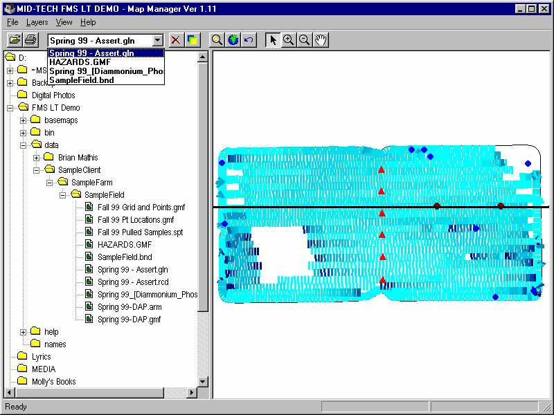
2 WHERE DO WE BEGIN? 1) Gather geo-referenced information from our field 2) Analyze data to form management zones 3) Write prescription files and create map 4) Make Precision Application 5) Create record of application Gather DGPS referenced information SOIL TYPE BOUNDRY MAP SOIL ph PEST OR DISEASE PRESSURE GIS INFO NUTRIENT LEVELS PAST HARVEST DATA T O P O EC Sensor

3 Image of Area Boundary Overlay


4 Soil Type Overlay Elevation Data

5 Prescription Map -Lime Rate_900 Identifies rate for applicators exact location Sends rate to controller Example of a contour map Prescription Map Rate_650 Identifies rate for applicators exact location Sends rate to controller Example of a grid map


6 As Applied Map * Receives Data from Rate Controller * Displays applied areas * Creates application report Prescription Map Demonstration

7 No Apply Zones The first step is identification Areas are located and plotted with a DGPS receiver and field mapping software All the attributes are added to the location at this time This may include: Wells, Houses, Swimming Pools, Public Recreation Areas, etc. This becomes a permanent record of applications and apply/no-apply zones
8 Image of area showing locations # # # Well locations with 300 setback # # #
9 Prescription map no product irrigation 20 lbs per acre The prescription map contains application rate data There are two specific rates for the above map : 0 and 20 lbs. per acre Equipped with a sub-meter DGPS receiver, the application equipment knows where it is located within the prescription map, and applies the rate specific to that location Well setbacks # # # Well locations are added to the Prescription map Set back zones are set up for each The set back zones are assigned a zero rate
10 Edited prescription map no product irrigation 20 lbs per acre # # # The setbacks are clipped out Those areas are then assigned a zero application rate As Applied Map # # # Red represents applicator travel with no product being applied Blue represents applicator travel with product being applied at 20 lb.. per acre
11 Close up of as applied map # Red represents applicator travel with no product being applied Blue represents applicator travel with product being applied at 20 lb.. per acre As Applied Map While product is being applied, the GPS controlled application equipment creates an as applied map The mapping software is receiving real time application data from the rate controller and the GPS receiver Once per second the mapping software logs a point Attached to that point is its latitude/ longitude coordinates, a GPS time stamp, the area the applicator is covering, and the rate the product is being applied This stream of logged points creates a permanent as applied map that is viewable in any GIS viewing software
12 Precision Application Components GPS Units Light Bars for Guidance Computers Controllers Software Application Equipment GPS Receivers DGPS, Differentially Corrected GPS is necessary for Variable Rate Application Correction sources are Beacon, Satellite, or WAAS Satellite correction requires a subscription Receivers should run at a minimum of 5hz at 4800 baud rate


, curved")


13 Smart Antennas DGPS Receivers GPS Antennas Light Bar Guidance Guidance systems should work the way you do. Flexible guidance patterns Parallel (straight-line), curved A-B, adaptive curves, and headland modes. Systems should warn when you overlap into a previously applied area. When you turn around, they automatically advance to the next swath.

14


15 Display Screen and Data Card

16


17 Tilt Compensation Module Tilt Compensation Module Corrects for side slope-induced position errors Installs in-line between GPS receiver and guidance device

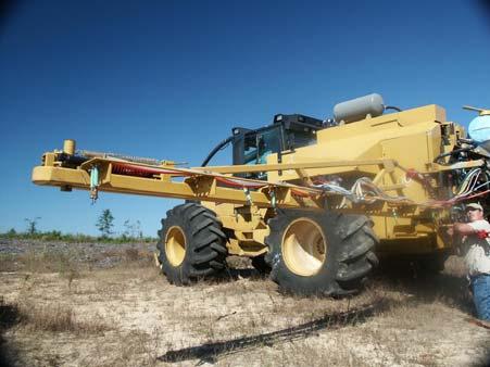
18 Computers and Controllers Stand Alone or Multiple Units?

19 Processor for Variable Rate Software Field Computers Laptops - compaq ipaq Accepts flash card with field prescription map Contains variable rate application software Legacy 6000 Controller


20 Chemical injection suction side Chemical injection suction side


21 Chemical injection pressure side Chemical injection pressure side

22 MT 600 Mixing Chamber Mixing Chamber Components FLOW DIRECTION Mixing Chamber 2 Diameter 8 Long Mixing Zone Polypropylene Mixer Vanes Glass Filled Polypropylene Retaining Rings End Fitting 2 Female NPT Polypropylene MT 600 Mixing Chamber Mixing Vanes Enter weaving sheering action coupled with multiple vortexes at high volumes Whirlpool Vortexes Left / Right Sheering Blending UP / Down Sheering

23 VARIABLE RATE SOFTWARE Communicates with Rate Controller and GPS Identifies location on prescription map Analyzes rate based on location Sends rate to controller Updates 5 times per second or faster Fieldware Application Report


24 Now Let s Put it Together Add Components to Chassis Tanks, Pump, Motor, Spray Boom, Computer, GPS, Software etc..


25 Boom Spray Nozzle Boomless Spray Nozzle


26 Sprayer and Pumping System Variable Rate Equipment Photo courtesy of Frank Corley-Corley Land Management Banding Nozzles Fertilizer Drip Tubes GPS Antenna Boomless Broadcast Nozzles Liquid Fertilizer Water tank with 3 chemical injection pumps and tanks Computer, Light Bar and Controller

27 Variable Rate Equipment Photo courtesy of Frank Corley-Corley Land Management Variable Rate Equipment Photo courtesy of Frank Corley-Corley Land Management
28 Questions or Comments? Chemical Containers Inc. PO Box 1307 Lake Wales, Fl Dana Ritenour
How is GPS Used in Farming? Equipment Guidance Systems
 GPS Applications in Crop Production John Nowatzki, Extension Geospatial Specialist, Vern Hofman, Extension Ag Engineer Lowell Disrud, Assistant Professor, Kraig Nelson, Graduate Student Introduction The
GPS Guidance Systems An Overview of the Components and Options
 GPS Guidance Systems An Overview of the Components and Options AEX-570-02 Matthew Sullivan, Extension Program Specialist M. Reza Ehsani, Assistant Professor As precision agriculture increases in popularity
CASE IH PRECISION AGRICULTURE
 CASE IH PRECISION AGRICULTURE PRECISION AGRICULTURE Boost Your Farm s Productivity with a Case IH Precision Farming System Precision farming arguably the most significant advancement in agriculture since
GNSS-Based Auto-Guidance Test Program Development
 ECPA (Skiathus( Skiathus,, Greece) June, GNSS-Based Auto-Guidance Test Program Development Viacheslav I. Adamchuk George E. Meyer Roger M. Hoy Michael F. Kocher George E. Meyer Michael F. Biological Systems
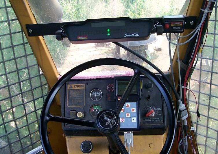
Swath Guidance Technology. Ron C. Johnson
 Swath Guidance Technology by Ron C. Johnson Widespread acceptance of new information technologies in agriculture may still be a long way off. But some producers and custom applicators are beginning to
Precision Ag: Profitability and Use. Ken O Brien 17 April 2008
 Precision Ag: Profitability and Use Ken O Brien 17 April 2008 My background? Raised mostly near Stuart, IA Attended Iowa State University to receive my undergraduate degree Three job roles since graduation
Understanding Controller Setup for Accurate Liquid Application
 Application Technology Series Understanding Controller Setup for Accurate Liquid Application Ajay Sharda, specialist, precision agriculture and machine systems; John W. Slocombe, extension agricultural
NR402 GIS Applications in Natural Resources
 NR402 GIS Applications in Natural Resources Lesson 5 GPS/GIS integration Global Positioning System (GPS)..a global navigation system that everyone can use What is GPS? How does it work? How accurate is
36. Global Positioning System
 36. Introduction to the Global Positioning System (GPS) Why do we need GPS? Position: a basic need safe sea travel, crowed skies, resource management, legal questions Positioning: a challenging job local
GNSS-Based Auto-Guidance Accuracy Testing
 AETC (Louisville, Kentucky) February, GNSS-Based Auto-Guidance Accuracy Testing Viacheslav I. Adamchuk Biological Systems Engineering University of Nebraska-Lincoln Background Auto-guidance (auto-steering)
COMPARISON OF A DGPS SYSTEM AND CONVENTIONAL GUIDANCE FOR SPRAYING APPLICATIONS.
 COMPARISON OF A DGPS SYSTEM AND CONVENTIONAL GUIDANCE FOR SPRAYING APPLICATIONS. Kevin McDougall, Peter Gibbings and Ivan Wolski Faculty of Engineering and Surveying University of Southern Queensland Toowoomba,
NJDEP GPS Data Collection Standards for GIS Data Development
 NJDEP GPS Data Collection Standards for GIS Data Development Bureau of Geographic Information Systems Office of Information Resource Management April 24 th, 2017 Table of Contents 1.0 Introduction... 3
Line and polygon features can be created via on-screen digitizing.
 This module explains how GPS works, sources of error, and error correction using real time or post processing differential correction. Cost and accuracy of different grades of GPS units are also part of
GPS Errors. Figure 1. Four satellites are required to determine a GPS position.
 Expl ai ni nggps:thegl obalposi t i oni ngsyst em since a minimum of four satellites is required to calculate a position (Fig 1). However, many newer GPS receivers are equipped to receive up to 12 satellite
Ag Leader EZ-Guide Quick Reference Card
 g Leader EZ-Guide Step 1: GPS antenna a. Mount the antenna on the highest part of the vehicle. Ensure that there are no obstructions in the way of the GPS antenna. b. Mount the antenna along the boom centerline
PRECISION FARMING AND VARIABLE RATE TECHNOLOGY A Resource Guide
 PRECISION FARMING AND VARIABLE RATE TECHNOLOGY First Edition February, 2010 Agricultural Research and Extension Council of Alberta (ARECA) 2010 ARECA Table of Contents List of Tables...iv List of Figures...v
Understanding Global Positioning Systems (GPS)
") Lesson A8 5 Understanding Global Positioning Systems (GPS) Unit A. Mechanical Systems and Technology Problem Area 8. Technology Systems Lesson 5. Understanding Global Positioning Systems (GPS) New Mexico
Lesson A8 5 Understanding Global Positioning Systems (GPS) Unit A. Mechanical Systems and Technology Problem Area 8. Technology Systems Lesson 5. Understanding Global Positioning Systems (GPS) New Mexico
GreenStar Display Measuring Offsets PC21926
 Display Measuring Offsets PC21926 Machine Offsets Row Crop Tractor A or 1) Center of GPS Receiver to Center line of Machine Applications requiring this setting include: Guidance Section Control Mapping
precision agriculture
 precision agriculture 2013 PRODUCT CATALOG www.topconpa.com F A R M I N G C Y C L E Powerful Precision Made Easy As a farm operator, you need to produce higher yields, more efficiently, to feed the ever-increasing
Survey Requirements. Design Guidelines and Standards. June Office of the University Architect
 Design Guidelines and Standards Survey Requirements June 2004 Office of the University Architect Construction Management P.O. Box 210181 Cincinnati, Ohio 45221-0181 Table of Contents Survey Requirements
How to do Geo-fencing with the FM200
 Handling a complex world. How to do Geo-fencing with the FM200 Introduction The ability to define custom user events for the FM200 unit, allows you to do Geo-fencing for vehicles fitted with GPS units.
Precision Agriculture. Solutions
 Precision Agriculture www.topconpa.com Solutions F A R M I N G C Y C L E Powerful Precision Made Easy As a farm operator, you need to produce higher yields, more efficiently, to feed the ever-increasing
John Deere Guidance Systems Guidance you can grow with
 John Deere Guidance Systems Guidance you can grow with 2 Guidance you can grow with: John Deere guidance systems Table of Contents John Deere guidance systems... 2 3 Receiver and signal choices... 4 5
RESOLUTION MSC.114(73) (adopted on 1 December 2000) ADOPTION OF THE REVISED PERFORMANCE STANDARDS FOR SHIPBORNE DGPS AND DGLONASS MARITIME RADIO
 (adopted on 1 December 2000) ADOPTION OF THE REVISED PERFORMANCE STANDARDS FOR SHIPBORNE DGPS AND DGLONASS MARITIME RADIO") MSC 73/21/Add.3 RESOLUTION MSC.114(73) FOR SHIPBORNE DGPS AND DGLONASS MARITIME RADIO BEACON RECEIVER EQUIPMENT THE MARITIME SAFETY COMMITTEE, RECALLING Article (28(b) of the Convention on the International
MSC 73/21/Add.3 RESOLUTION MSC.114(73) FOR SHIPBORNE DGPS AND DGLONASS MARITIME RADIO BEACON RECEIVER EQUIPMENT THE MARITIME SAFETY COMMITTEE, RECALLING Article (28(b) of the Convention on the International
Opportunities and Limitations of Automatic Steering Technologies. Nyle Wollenhaupt Advanced Technology Solutions Agronomist
 Opportunities and Limitations of Automatic Steering Technologies Nyle Wollenhaupt Advanced Technology Solutions Agronomist So where do we start? We start at the beginning. When we didn t have GPS-assisted
Receiver Technology CRESCENT OEM WHITE PAPER AMY DEWIS JENNIFER COLPITTS
 CRESCENT OEM WHITE PAPER AMY DEWIS JENNIFER COLPITTS With offices in Kansas City, Hiawatha, Calgary and Scottsdale, Hemisphere GPS is a global leader in designing and manufacturing innovative, costeffective,
Basic Measurements for Pipe Inspections
 Basic Measurements for Pipe Inspections Period 7 Basic Corrosion Course 2017 February 21-23, 2017 Mark Anderson-MTS 1 DOT 192.459 External corrosion control: Examination of buried pipeline when exposed.
System competence Optimum steering
 System competence Optimum steering Steer or let steer? It's up to you! Since satellite technology with GPS functions was first introduced into agriculture, the development from simple steering aids to
GreenSeeker Handheld Crop Sensor Features
 GreenSeeker Handheld Crop Sensor Features Active light source optical sensor Used to measure plant biomass/plant health Displays NDVI (Normalized Difference Vegetation Index) reading. Pull the trigger
Preparation Analysis on Effect Factors of Spraying Quality for Boom Sprayer
 , pp.49-55 http://dx.doi.org/10.14257/astl.2015.111.10 Preparation Analysis on Effect Factors of Spraying Quality for Boom Sprayer Wenfeng Sun 1,, Qichao Li 1, Yongcun Fan 2 1 Engineering Institute, Northeast
Technology to Improve Sprayer Accuracy
 PA-9 Technology to Improve Sprayer Accuracy Tim Stombaugh, Biosystems and Agricultural Engineering University of Kentucky College of Agriculture, Food and Environment Cooperative Extension Service number
08/10/2013. Marine Positioning Systems Surface and Underwater Positioning. egm502 seafloor mapping
 egm502 seafloor mapping lecture 8 navigation and positioning Marine Positioning Systems Surface and Underwater Positioning All observations at sea need to be related to a geographical position. To precisely
MJK Expert 700 / 800 / 900 / 1100 / 2100 MJK Expert 1400 / 3400
 Data Sheet MJK Expert 700 / 800 / 900 / 1100 / 2100 MJK Expert 1400 / 3400 Submersible Hydrostatic s Rugged and versatile We reserve the right to continuously improve our products and make any change in
AUTO CAL II PO Box Sta Safety Road Houma, LA Tel # Fax #
 AUTO CAL II PO Box 10083 Sta. 1 233 Safety Road Houma, LA 70363 Tel # 985-868-1477 Fax # 985-879-1617 e-mail - autocalflow@aol.com www.autocalflow.com Operating Instructions American System SW 1 SW 2 SW
5.7 Plan Documentation and Supporting Information.
 5.7 and Supporting Information. In any case where the and Supporting Information for a Development Plan requires the submission of a Site Plan, Overall Plan, Landscape Plan, Building Elevations, Sign Plan
Addressing Issues with GPS Data Accuracy and Position Update Rate for Field Traffic Studies
 Addressing Issues with GPS Data Accuracy and Position Update Rate for Field Traffic Studies THIS FEATURE VALIDATES INTRODUCTION Global positioning system (GPS) technologies have provided promising tools
DEVELOPMENT OF AN INTELLIGENT YIELD MONITOR FOR GRAIN COMBINE HARVESTER
 DEVELOPMENT OF AN INTELLIGENT YIELD MONITOR FOR GRAIN COMBINE HARVESTER Minzan Li, Peng Li, Qi Wang, Jianqing Fang, Maohua Wang Key laboratory of Modern Precision Agriculture System Integration Research,
LAB 1 METHODS FOR LOCATING YOUR FIELD DATA IN GEOGRAPHIC SPACE. Geog 315 / ENSP 428
 LAB 1 METHODS FOR LOCATING YOUR FIELD DATA IN GEOGRAPHIC SPACE Geog 315 / ENSP 428 Lab 1 Schedule Introduction to bio-physical field data collection (8:00-8:20am) Locating your data on the earth: NAVSTAR
Real Time Kinematic VALUE GUIDE (US, Canada, Australia & New Zealand) CLICK THE ARROW TO GET STARTED
 CLICK THE ARROW TO GET STARTED") Real Time Kinematic VALUE GUIDE (US, Canada, Australia & New Zealand) Copyright 2014 Deere & Company This material is the property of Deere & Company. All use, disclosure, and/or reproduction not specifically
Real Time Kinematic VALUE GUIDE (US, Canada, Australia & New Zealand) Copyright 2014 Deere & Company This material is the property of Deere & Company. All use, disclosure, and/or reproduction not specifically
Yavapai County Development Services
 Yavapai County Development Services Prescott Office 1120 Commerce Dr., Prescott, AZ 86305 (928) 771-3214 Fax: (928) 771-3432 Cottonwood Office 10 S. 6 th Street, Cottonwood, AZ 86326 (928) 639-8151 Fax:
UNITED NATIONS UNIVERSITY Institute for Environment & Human Security (UNU-EHS) Bonn, Germany
 Bonn, Germany") UNITED NATIONS UNIVERSITY Institute for Environment & Human Security (UNU-EHS) Bonn, Germany Introduction to GPS technology Prof. Dr. Jörg Szarzynski Education Programme Director Head of Section EduSphere
UNITED NATIONS UNIVERSITY Institute for Environment & Human Security (UNU-EHS) Bonn, Germany Introduction to GPS technology Prof. Dr. Jörg Szarzynski Education Programme Director Head of Section EduSphere
Agrosky. Precision agriculture.
 Agrosky. Precision agriculture. DEUTZ-FAHR, SAME, LAMBORGHINI and HÜRLIMANN take the top option. The production cycle Farmers have always been under pressure to produce more food as the population increases,
Date Requested, 200_ Work Order No. Funding source Name of project Project limits: Purpose of the project
 Bureau of Engineering SURVEY DIVISION REQUEST FOR TOPOGRAPHIC SURVEY Date Requested, 200_ Work Order No. Funding source Name of project Project limits: Purpose of the project Caltrans involvement (must
Introduction to the Global Positioning System
 GPS for Fire Management - 2004 Introduction to the Global Positioning System Pre-Work Pre-Work Objectives Describe at least three sources of GPS signal error, and identify ways to mitigate or reduce those
GNSS & Coordinate Systems
 GNSS & Coordinate Systems Matthew McAdam, Marcelo Santos University of New Brunswick, Department of Geodesy and Geomatics Engineering, Fredericton, NB May 29, 2012 Santos, 2004 msantos@unb.ca 1 GNSS GNSS
Drip In Classic Turbulent Flow Dripline
 Drip In Classic Turbulent Flow Dripline Ag Irrigation Application: Drip In Classic is the most effective and economical choice for most permanent and row crop applications. The hose with the integral in-line
MATRIX 430. Entry level guidance Software version 1.03
 MATRIX 430 U S E R M A N U A L Entry level guidance Software version 1.03 GETTING STARTED 1. Power on the console. Setup machine 2. On guidance screen, press NAVIGATION AND GUIDANCE OPTIONS tab to display
ECM HIGH EFFICIENCY CIRCULATORS
 ECM HIGH EFFICIENCY CIRCULATORS WILO STRATOS Stratos Commercial high efficiency pumpp Main features & benefits 0-285 Gal/min flow 3 40 ft head 8 models (1.25, 1.5, 2 & 3 ) EC motor (permanent magnet rotor)
Y1. 5.Select Application Type and Application Mode. 6. Set up Section Groups. Section Group 2 will start with Section
 396-3563Y1 QuickStart setup instructions for JDRC 2000 and SureFire harness for 2 Liquid/Dry Products 213-00-3453Y1 213-00-3538Y1 213-00-3467Y1 213-00-3585Y1 Below are typical SureFire Liquid Fertilizer
VARIABLE FREQUENCY DRIVE SPECIFICATION
 VARIABLE FREQUENCY DRIVE SPECIFICATION 1.0. SUMMARY The use of variable frequency drives (VFDs) in conjunction with wastewater lift stations has been identified as a means improve efficiency and to moderate
Highly accurate on each field. For all vehicles and implements PSR GUIDANCE SYSTEMS
 Highly accurate on each field For all vehicles and implements PSR GUIDANCE SYSTEMS PSR the right solution for automatic guidance of tractors and implements RTK CLUE the key to costefficient RTK corrections
GPS Position Sensor PS-2175
 In s tr u c ti o n M a n u a l 012-09919A GPS Position Sensor PS-2175! Table of Contents Contents Introduction........................................................... 3 Theory of Operation....................................................
Stations & Dataloggers
 INTERFACES RS232 Interface RS232 A standard Interface that allows serial communication transmission of data. Stations & Dataloggers YOU CAN CONNECT: One piece of the following sensors: Sommer MessTechnik
RESOLUTION MSC.112(73) (adopted on 1 December 2000) ADOPTION OF THE REVISED PERFORMANCE STANDARDS FOR SHIPBORNE GLOBAL POSITIONING SYSTEM (GPS)
 (adopted on 1 December 2000) ADOPTION OF THE REVISED PERFORMANCE STANDARDS FOR SHIPBORNE GLOBAL POSITIONING SYSTEM (GPS)") MSC 73/21/Add.3 RESOLUTION MSC.112(73) FOR SHIPBORNE GLOBAL POSITIONING SYSTEM THE MARITIME SAFETY COMMITTEE, RECALLING Article (28(b) of the Convention on the International Maritime Organization concerning
MSC 73/21/Add.3 RESOLUTION MSC.112(73) FOR SHIPBORNE GLOBAL POSITIONING SYSTEM THE MARITIME SAFETY COMMITTEE, RECALLING Article (28(b) of the Convention on the International Maritime Organization concerning
GPS-G5 User s Manual
 GPS-G5 User s Manual Contents Using the GPS... 1 Description...1 Electrical Connections...2 Mounting...3 GPS Configuration...3 GPS Operation...3 Logging Device Configuration...4 Data Analysis...5 Specifications...
ZONESCAN net Version 1.4.0
 ZONESCAN net.0 REV 1. JW ZONESCAN net 2 / 56 Table of Contents 1 Introduction... 5 1.1 Purpose and field of use of the software... 5 1.2 Software functionality... 5 1.3 Function description... 6 1.3.1
SureFire Ag S 1.11A. 5.Select Application Type and Application Mode. 6. Set up Section Groups. Section Group 2 will start with Section
 396-3563Y1 QuickStart setup instructions for JDRC 2000 and SureFire harness for 2 Liquid/Dry Products 213-00-3453Y3 213-00-3538Y4 213-00-3467Y4 213-00-3585Y3 Below are typical SureFire Liquid Fertilizer
RGL 500 USER S GUIDE
 RGL 500 USER S GUIDE NOTICE To ensure that no moisture will penetrate the RGL-400 and RGL-500 Light Bar enclosure, it has been determined that the Light Bar NEVER be washed or cleaned with a power washer
A Submersible Global Positioning System Receiving Antenna. John D. Moore Sound Ocean Systems, Inc.
 A Submersible Global Positioning System Receiving Antenna John D. Moore Sound Ocean Systems, Inc. jdmoore@soundocean.com Abstract Long endurance missions using Autonomous Underwater Vehicles (AUVs) to
Addendum 1.4_2. (Addendum to MX420 Operator s Manual)
") _2 (Addendum to MX420 ) September, 2007 Table of Contents About this document..1 MX575 Heading & Rate of Turn 2 MX575 as a D/GPS Compass only 2 MX575 as a D/GPS Compass with Navigation Functionality.....4
_2 (Addendum to MX420 ) September, 2007 Table of Contents About this document..1 MX575 Heading & Rate of Turn 2 MX575 as a D/GPS Compass only 2 MX575 as a D/GPS Compass with Navigation Functionality.....4
Over the past 30 years
 GNSS applications for agricultural practices Application by Guy Blanchard Ikokou, University of Cape Town Global positioning systems are relatively new technologies when it comes to applications in agriculture.
Industrial Instrumentation
 Industrial Instrumentation Dr. Ing. Naveed Ramzan Course Outline Instruments are our eyes Fundamentals of Electrical Technology and digital logic employed in the measurement Review of Scientific principles
Shape File Attribute Grain Harvest
 Shape File Attribute Grain Harvest SMS Attribute and Unit Required Attributes Property: - Management Item: Crop_Flw_M Attribute: Crop Flow (Mass)- lbs/s Moisture Attribute: Moisture- % Grain_Temp Attribute:
STRIKER Series. Owner s Manual
 STRIKER Series Owner s Manual Table of Contents Introduction...1 Device Keys... 1 Contacting Garmin Product Support... 1 Selecting the Transducer Type... 1 Zooming on the STRIKER 4... 1 Panning on the
SUGAR_GIS. From a user perspective. Provides spatial distribution of a wide range of sugarcane production data in an easy to use and sensitive way.
 SUGAR_GIS From a user perspective What is Sugar_GIS? A web-based, decision support tool. Provides spatial distribution of a wide range of sugarcane production data in an easy to use and sensitive way.
High Gain Advanced GPS Receiver
 High Gain Advanced GPS Receiver NAVSYS Corporation 14960 Woodcarver Road, Colorado Springs, CO 80921 Introduction The NAVSYS High Gain Advanced GPS Receiver (HAGR) is a digital beam steering receiver designed
AEROS Software version 4.32
 AEROS 9040 U S E R G U I D E Software version 4.32 Table of Contents START SIMPLE GUIDANCE 1 #1 POWER ON 1 #2 HOME SCREEN 1 System Setup...1 RealView Camera Full Screen Video View...1 ISOBUS Universal
Power Requirements. Features
 Datasheet Positional accuracy (CEP50) autonomous positional error less than 2.5 meters SiRF Star IV GPS chip Satellite-based augmentation systems: WAAS, EGNOS, MSAS, GAGAN High sensitivity navigation engine
IOP:018.4 U.S. Fish and Wildlife Service INSTRUMENT OPERATING PROCEDURE
 IOP:018.4 January 9, 2017 U.S. Fish and Wildlife Service Marquette Biological Station 3090 Wright Street Marquette, Michigan 49855 U.S.A. and U.S. Fish and Wildlife Service Ludington Biological Station
The Global Positioning Sytem II 10/19/2017
 The Global Positioning System II Field Experiments 10/19/2017 5-1 Mexico DGPS Field Campaign Cenotes in Tamaulipas, MX, near Aldama 10/19/2017 5-2 Are Cenote Water Levels Related? 10/19/2017 5-3 M. Helper,
EASY. CLAAS steering systems
 EASY CLAAS steering systems Contents Customer benefits 4 History 6 Types of steering system 8 GPS COPILOT, GPS PILOT FLEX 10 GPS PILOT 12 Components 14 TURN IN, AUTO TURN 16 Terminals 18 Combination options,
CLAAS steering systems
 CLAAS steering systems EASY. More to rely on. The name says it all. The combined electronic competence of CLAAS can be summed up in a single word: EASY. This stands for Efficient Agriculture Systems and
Model 50 Ground Loop ph Sensor Model 55 Solution Ground ph Sensor
 Model 50 Ground Loop ph Sensor Model 55 Solution Ground ph Sensor Features Patented Plunger 1 ph Electrode Design Patented Porous 2 Teflon Liquid Junctions Double Junction Reference Cell Integral Differential
The Global Positioning System II Field Experiments. 10/10/2013 GEO327G/386G, UT Austin 5-1
 The Global Positioning System II Field Experiments 10/10/2013 GEO327G/386G, UT Austin 5-1 Mexico DGPS Field Campaign Cenotes in Tamaulipas, MX, near Aldama 10/10/2013 GEO327G/386G, UT Austin 5-2 Are Cenote
Prof. Maria Papadopouli
 Lecture on Positioning Prof. Maria Papadopouli University of Crete ICS-FORTH http://www.ics.forth.gr/mobile 1 Roadmap Location Sensing Overview Location sensing techniques Location sensing properties Survey
EMERGING TECHNOLOGIES FOR GIS/GPS MAPPING FOR PIPELINES
 EMERGING TECHNOLOGIES FOR GIS/GPS MAPPING FOR PIPELINES 2003 Petroleum User s Conference Houston March 11, 2003 By: Ashok Wadwani Applied Field Data Systems, Inc. Houston, Texas Phone No.: 281-579-0492
GPS for Snowmobilers. By Wayne Fischer. November 14, 2006
 GPS for Snowmobilers By Wayne Fischer November 14, 2006 Wayne@TahoeSnowmobiling.org Copy of White Paper & Presentation Both this presentation and the white paper are available on the www.tahoesnowmobiling.org
Experiences with Hydrographic Data Budgets Using a Low-logistics AUV Platform. Thomas Hiller Teledyne Marine Systems
 Experiences with Hydrographic Data Budgets Using a Low-logistics AUV Platform Thomas Hiller Teledyne Marine Systems 1 Teledyne Marine Systems Strategic Business Units 2 What is the Gavia? The Gavia is
GEOGRAPHIC INFORMATION SYSTEMS Lecture 22: Field Mapping with GPS
 GEOGRAPHIC INFORMATION SYSTEMS Lecture 22: Field Mapping with GPS GPS Receivers - there are many GPS receivers on the market today - some receivers are relatively inexpensive (recreational grade receivers)
Helicopter Aerial Laser Ranging
 Helicopter Aerial Laser Ranging Håkan Sterner TopEye AB P.O.Box 1017, SE-551 11 Jönköping, Sweden 1 Introduction Measuring distances with light has been used for terrestrial surveys since the fifties.
ZONESCAN net Version 1.4.1
 ZONESCAN net REV 3 JW ZONESCAN net 2 / 59 Table of Contents 1 Introduction... 5 1.1 Purpose and field of use of the software... 5 1.2 Software functionality... 5 1.3 Function description... 6 1.3.1 Structure...
Field Testing of Vision Based Macadamia Yield Monitoring
 Field Testing of Vision Based Macadamia Yield Monitoring Mark Dunn 1, John Billingsley 1 and David Bell 2 1 National Centre for Engineering in Agriculture Faculty of Engineering and Surveying University
George Vellidis Crop & Soil Sciences Department University of Georgia
 THE UNIVERSITY OF GEORGIA SMART SENSOR ARRAY George Vellidis Crop & Soil Sciences Department University of Georgia yiorgos@uga.edu The UGA Smart Sensor Array (UGA SSA) consists of smart sensor nodes and
OPTIC EYE IN SKY UNMANNED AIRCRAFT FOR IDENTIFY BLEMISH AND CONSERVING CROPS IN CULTIVATED AGRICULTURAL LANDS
 OPTIC EYE IN SKY UNMANNED AIRCRAFT FOR IDENTIFY BLEMISH AND CONSERVING CROPS IN CULTIVATED AGRICULTURAL LANDS Gugainamasivayam S [1], Srinivasan M [2]. E-mail id: gugai.namasivayam@gmail.com [1] ABSTRACT:
Exploring GPS Data for Operational Analysis of Farm Machinery
 Research Journal of Applied Sciences, Engineering and Technology 5(12): 3281-3286, 2013 ISSN: 2040-7459; e-issn: 2040-7467 Maxwell Scientific Organization, 2013 Submitted: May 04, 2012 Accepted: May 29,
Using Malå GPR systems with GPS equipment
 Using Malå GPR systems with GPS equipment Description of problem In many situations it is convenient to use a GPS to keep track of the position in terms of x- and y-coordinates for all measured GPR profiles.
SITRANS F flowmeters. SITRANS F M System information MAGFLO electromagnetic flowmeters. 4/18 Siemens FI
 Function All are based on Faraday s law of induction: U M = B v d k U M = Measured voltage induced in the medium perpendicular to the magnetic field and the flow direction. The voltage is tapped at two
Department of Civil and Environmental Engineering
 Department of Civil and Environmental Engineering CEE213L Surveying & Introduction to GIS Lab SURVEYING LABORATORY NORTH SOUTH UNIVERSITY Center of Excellence in Higher Education The First Private University
Onlot System Component Matrix
 Onlot System Component Matrix Absorption Area Component Classification and Secondary / Advanced Treatment Options Slope Minimum Suitable Soil Depth to a Seasonal High-Water Table Limiting Zone Minimum
di-gps Eco ProSumer digital images GPS receiver
 di-gps Eco ProSumer digital images GPS receiver Users Guide Ver 1.01 Please visit our website www.di-gps.com for the latest version of the user guide CONTENTS CONTENTS... 1 INTRODUCTION... 2 WARNING /
City of Aspen Water Review for Pitkin County Permits Submission Packet
 Projects that propose adding, removing, or changing any plumbing fixtures (e.g. faucets, toilets, dishwashers, hose bibs, etc.) are subject to the ECU/Fixture Count component of the review, and the following
MINOR SITE PLAN APPLICATION COVER SHEET
 MINOR SITE PLAN APPLICATION COVER SHEET TOWN OF CLAYTON Planning Department 111 E. Second St., P.O. Box 879 Clayton, NC 27528 Phone: 919-553-5002 Fax: 919-553-1720 Name of Project: Date: Applicant Name:
AG-VA Fully Autonomous UAV Sprayers
 AG-VA Fully Autonomous UAV Sprayers One of the most advance sprayer technology on the market! Best Price - Best Flight Time - Best Coverage Rate - 1 Yr Warranty* The AG-VA UAV Sprayer is available in 3
CORSnet-NSW. accurate reliable easy.
 CORSnet-NSW accurate reliable easy www.lpma.nsw.gov.au www.corsnet.com.au CORSnet-NSW supporting NSW farmers The NSW rural community is using precision agriculture techniques such as Variable Rate Applications,
di-gps Eco ProSumer PS10-M digital images GPS receiver
 di-gps Eco ProSumer PS10-M digital images GPS receiver Users Guide Ver 1.03 Please visit our website www.di-gps.com for the latest version of the user guide CONTENTS CONTENTS... 1 INTRODUCTION... 2 WARNING
What is it? History. Other systems. How does it work? Trilateration GEOG 201 4/28/2010. Instructor: Pesses 1. {06} The Global Positioning System
 What is it? {06} The Global Positioning System G.P.S. = Global Positioning System Different from G.I.S. (Geographic Information Systems) Map Interpretation & GPS Spring 2010 M. Pesses History Conceived
GPS: What do I need to collect Application Appropriate location data?
 GPS: What do I need to collect Application Appropriate location data? Bob Goodwin, GISP GIS/Remote Sensing Analyst Remote Sensing & GIS Research and Outreach Services, MSU http://www.rsgis.msu.edu 2005
Lecture 8: GIS Data Error & GPS Technology
 Lecture 8: GIS Data Error & GPS Technology A. Introduction We have spent the beginning of this class discussing some basic information regarding GIS technology. Now that you have a grasp of the basic terminology
Remote Sensing in Daily Life. What Is Remote Sensing?
 Remote Sensing in Daily Life What Is Remote Sensing? First time term Remote Sensing was used by Ms Evelyn L Pruitt, a geographer of US in mid 1950s. Minimal definition (not very useful): remote sensing
Leica GRX1200 Series High Performance GNSS Reference Receivers
 Leica GRX1200 Series High Performance GNSS Reference Receivers Leica GRX1200 Series For permanent reference stations The Leica GRX1200 Series, part of Leica s new System 1200, is designed specifically