GOES-R: Significance of Spatial Resolution in Satellite Imagery
|
|
|
- Daniella Stone
- 6 years ago
- Views:
Transcription
.")

.")

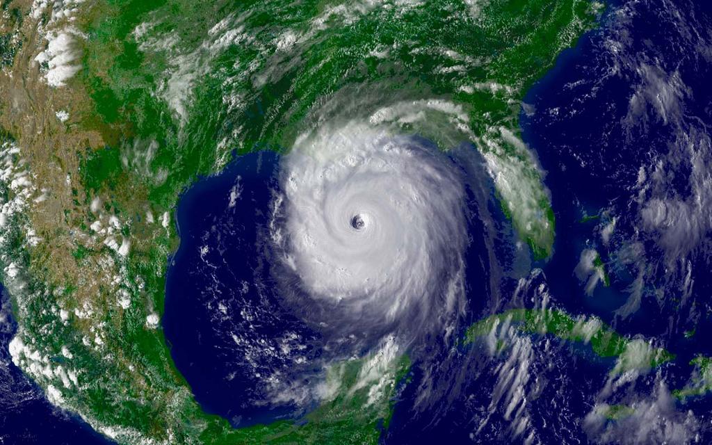
1 GOES-R: Significance of Spatial Resolution in Satellite Imagery Source/Authors: Peter Dorofy, John Moore, The Institute for Earth Observations at Palmyra Cove Nature Park, Palmyra, NJ ( Vicky Gorman, Medford Memorial School, Medford, NJ Overview: The Geostationary Operational Environmental Satellites R Series (GOES-R) is the next generation of geostationary Earth-observing systems. The GOES-R program is a collaborative development and acquisition effort between the GOES-R Official Logo National Oceanic and Atmospheric Administration (NOAA) and the National Aeronautics and Space Administration (NASA). The advanced spacecraft and instrument technology employed by the GOES-R series will provide significant improvements in the detection and observations of environmental phenomena that directly affect public safety, protection of property and our nation s economic health and prosperity. The first satellite in the GOES-R series is scheduled for launch in early The Advanced Baseline Imager is the primary instrument on GOES-R for imaging Earth s weather, oceans and environment. The ABI will provide four times the spatial resolution of current GOES instruments. Increased spatial resolution allows meteorologists to pinpoint and track developing storms in greater detail. More information about GOES-R can be found at
2 Purpose: To explain the value and use of sensors such as the GOES-R ABI to provide higher spatial Purpose: resolutions in satellite imagery. Grade Level: Level: The lesson is appropriate for primary, middle, and secondary schools. Some of the terminology will need to be adjusted for primary. The mathematics may be more appropriate for middle and secondary school students. Student Outcomes: Observe satellite images at different resolutions. Define pixel density. Identify land, water, and atmospheric features. Define and demonstrate image analysis. Approximate the area of a particular feature. Explain the value and use of higher spatial resolutions. Prerequisite: Students should know that a satellite image is a digital visualization that models data acquired by a satellite. Students should also know what pixels are and that satellite images are composed of pixels.
3 Next Generation Science Standards: The sets below from the Next Generation Science Standards (NGSS) are relevant to this lesson. Each set may include a disciplinary core idea (DCI), science and engineering practice (SEP), crosscutting concept (CC), and a performance expectation (PE). The sets represent a sampling of what may be derived from the NGSS. GRADES K-2 SEP: Use a model to represent relationships in the natural world. (K-ESS3-1) SEP: Make observations (firsthand or from media) to collect data that can be used to make comparisons. (K-PS3-1) SEP: Use observations (first hand or from media) to describe patterns in the natural world in order to answer scientific questions. (1-ESS1-1) CC: Patterns in the natural world can be observed, used to describe phenomena, and used as evidence. (K-ESS2-1) CC: Scientists study the natural and material world. (2-ESS2-1) GRADES 3-5 DCI: A variety of hazards result from natural processes (e.g., earthquakes, tsunamis, volcanic eruptions). Humans cannot eliminate the hazards but can take steps to reduce their impacts. (4-ESS3-2) SEP: Represent data in tables and various graphical displays (bar graphs and pictographs) to reveal patterns that indicate relationships. (3-ESS2-1) SEP: Describe and graph quantities such as area and volume to address scientific questions. (5-ESS2-2) CC: Engineers improve existing technologies or develop new ones. (4-PS3-4) GRADES 6-8 PE: ESS3-2. Analyze and interpret data on natural hazards to forecast future catastrophic events and inform the development of technologies to mitigate their effects. CC: Graphs, charts, and images can be used to identify patterns in data. (MS-ESS3-2) GRADES 9-12 SEP: Analyze data using tools, technologies, and/or models (e.g., computational, mathematical) in order to make valid and reliable scientific claims or determine an optimal design solution. (HS-ESS2-2)
4 Preparation: Print and cut out the six satellite images that accompany the lesson. Since students will work in groups of 4-6, make a set for each group. It is recommended that you number the images 1-6 as well as laminate them for endurance. The resolutions of the images are in the following order: 8x5, 16x10, 32x20, 64x40, 128x80, and 1920x1080. As a side note, the area of coverage for each image is 3500km x 2200km.
5 Procedure: 1. Arrange students into groups of 4-6 students per group. 2. Give each group the first lowest resolution image (8x5). DO NOT GIVE OUT ALL IMAGES. 3. Explain to the students that the image is low resolution 8x5. Use the following questions: What does an 8x5 pixel image mean? How many total pixels make up this image? What are some of the different colors you see? What surface features do you think are identified by each color? What do you think the satellite image is of? 4. Give each group the next highest resolution image (16x10). 5. Explain to the students that pixel density is the number of pixels per area of coverage. 6. Use the following questions: Has the pixel density increased or decreased? How many total pixels make up this image? Has the pixel density increased or decreased? How many times more is the pixel density then the first image? 7. Repeat for the remaining images, asking students to refine their observations until they guess the image correctly. The last image, 6, is at full resolution 1920x Have students compare the 4 th and 5 th images. Use the following questions: What feature(s) seem to be more resolved at the higher resolution? 9. Have the students examine the eye of the hurricane using Image 5. Use the following questions: How many pixels do you count within the eye? If each pixel covers an area of approximately 700 square kilometers, how many total square kilometers does the eye cover? 10.Have the students examine Image 6. Use the following questions: Would it be easy or difficult to count the number of pixels in the eye? 11.Explain to students that image analysis software is used to count pixels. The result would be a more precise value of area. 12.Have students discuss the value of using an instrument, such as ABI, which has a spatial resolution multiple times that of current GOES satellite instruments. Extension/Challenge: The equation to find area of a circle is pi*radius 2. Challenge the students to calculate the area of the hurricane s eye and compare it to counting pixels. The students will need to determine the scale [km per pixel]. Each image covers an area of 3500km x 2200km.
6 About The Institute for Earth Observations: The Institute of Earth Observations is an ongoing educational endeavor to engage teachers and students in an innovative study of Planet Earth from both earthbound and space borne perspectives using state-of-the-art technologies, instructional strategies, and educational resources to expose students to the practices of gathering and application of Environmental Intelligence.
7
8
9
10
11
12
Satellite Imagery and Remote Sensing. DeeDee Whitaker SW Guilford High EES & Chemistry
 Satellite Imagery and Remote Sensing DeeDee Whitaker SW Guilford High EES & Chemistry whitakd@gcsnc.com Outline What is remote sensing? How does remote sensing work? What role does the electromagnetic
Sensor Technologies and Sensor Materials for Small Satellite Missions related to Disaster Management CANEUS Indo-US Cooperation
 Sensor Technologies and Sensor Materials for Small Satellite Missions related to Disaster Management CANEUS Indo-US Cooperation Suraj Rawal, Lockheed Martin Space Systems Co., USA G. Mohan Rao, Indian
21 st Century Skills. Describe how satellite data is transmitted from space to Earth,
 Level of Difficulty: 4 Grade Range: 9-12 Activity Time: 45-60 min Business Category: IT Topic: Information and Communication OVERVIEW Information and Communication In this lesson, students will explore
Connecting STEM and Environmental Education
 Connecting STEM and Environmental Education Mid-Atlantic Environmental Literacy Summit December 2, 2013 Louisa Koch NOAA Director of Education www.education.noaa.gov Louisa.Koch@NOAA.GOV 1 Outline NOAA,
Diocese of Knoxville Science Standards Framework
 Diocese of Knoxville Science Standards Framework Disciplinary Core Ideas and Components The basis of the standards is derived from the National Research Council s A Framework for K- 12 Science Education:
Science and Engineering Leveled Readers, and ScienceSaurus :
 hmhco.com Science & Engineering, and : Correlation to Next Generation Science Standards Meet higher standards with high-quality K 5 science resources from HMH! 2 Table of Contents Grade K Correlation...
GHS Parent Seminar Series Next Generation Science Standards. Daphne Traeger Teacher on Special Assignment, Science
 GHS Parent Seminar Series Next Generation Science Standards Daphne Traeger Teacher on Special Assignment, Science Agenda What are the Next Generation Science Standards (NGSS)? How were the NGSS developed?
Related Features of Alien Rescue
 National Science Education Standards Content Standards: Grades 5-8 CONTENT STANDARD A: SCIENCE AS INQUIRY Abilities Necessary to Scientific Inquiry Identify questions that can be answered through scientific
Paula Keener, Marine Biologist Director, Education Program NOAA Office of Ocean Exploration and Research
 Paula Keener, Marine Biologist Director, Education Program NOAA Office of Ocean Exploration and Research 1 2 3 Explain what these are 4 5 Ask participants to think about connections between science, engineering
IKONOS High Resolution Multispectral Scanner Sensor Characteristics
 High Spatial Resolution and Hyperspectral Scanners IKONOS High Resolution Multispectral Scanner Sensor Characteristics Launch Date View Angle Orbit 24 September 1999 Vandenberg Air Force Base, California,
CGMS-37, NOAA-WP-33 Prepared by NOAA Agenda Item: IV/1 Discussed in WG IV
 Prepared by NOAA Agenda Item: IV/1 Discussed in WG IV NOAA-WP-33 provides a status of its Geostationary Operational Environmental Satellite Series R (GOES-R). and polar-orbiting satellite constellations.
Fairfield Public Schools Science Curriculum. Draft Forensics I: Never Gone Without a Trace Forensics II: You Can t Fake the Prints.
 Fairfield Public Schools Science Curriculum Draft Forensics I: Never Gone Without a Trace Forensics II: You Can t Fake the Prints March 12, 2018 Forensics I and Forensics II: Description Forensics I: Never
This image cannot currently be displayed. Course Catalog. General Science I Glynlyon, Inc.
 This image cannot currently be displayed. Course Catalog General Science I 2016 Glynlyon, Inc. Table of Contents COURSE OVERVIEW... 1 UNIT 1: WHAT IS SCIENCE?... 1 UNIT 2: PERCEIVING THINGS... 1 UNIT 3:
Curriculum Catalog
 2017-2018 Curriculum Catalog 2017 Glynlyon, Inc. Table of Contents GENERAL SCIENCE I COURSE OVERVIEW...1 UNIT 1: WHAT IS SCIENCE?... 1 UNIT 2: PERCEIVING THINGS... 1 UNIT 3: EARTH IN SPACE (1)... 2 UNIT
2017 REMOTE SENSING EVENT TRAINING STRATEGIES 2016 SCIENCE OLYMPIAD COACHING ACADEMY CENTERVILLE, OH
 2017 REMOTE SENSING EVENT TRAINING STRATEGIES 2016 SCIENCE OLYMPIAD COACHING ACADEMY CENTERVILLE, OH This presentation was prepared using draft rules. There may be some changes in the final copy of the
COURSE OF STUDY GUIDE CAPE MAY REGIONAL SCHOOL DISTRICT
 COURSE OF STUDY GUIDE CAPE MAY REGIONAL SCHOOL DISTRICT TITLE OF COURSE: LIFE SCIENCE DEPARTMENT: SCIENCE GRADE: 7 DATE REVISED: JULY 2016 Lori Schulte, Heather Shagren, Shelley Vogelei I. COURSE ORGANIZATION
Next Generation Science Standards and Life Sciences
 Next Generation Science Standards and Life Sciences John Olson Minnesota Dept. of Education Building on the Past; Preparing for the Future Phase I Phase II 1990s 1990s-2009 7/2011 March 2013 1/2010-7/2011
Science Test Practice Grade 5
 Science Test Practice Grade 5 Published by Frank Schaffer Publications Editor: Karen Thompson Frank Schaffer Publications Printed in the United States of America. All rights reserved. Limited Reproduction
Greg Mandt. AMS 90 th Annual Meeting 6th Annual Symposium on Future National Operational Environmental Satellite Systems NPOESS and GOES R
 An Overview of the GOES R Program Greg Mandt System Program Director AMS 90 th Annual Meeting 6th Annual Symposium on Future National Operational Environmental Satellite Systems NPOESS and GOES R January19
Franklin Special School District Grade 3 Science
 THIRD GRADE: OVERVIEW The academic standards for third grade establish the content knowledge and skills for Tennessee students necessary to prepare them for the rigorous levels of higher education and
Title: How steep are those hills? Engineering Grade: Estimated Time: 3 hours (2 days) Groups: 3 to 4 students
 Groups: 3 to 4 students") Title: How steep are those hills? Engineering Grade: 10-12 Estimated Time: 3 hours (2 days) Groups: 3 to 4 students Synopsis: Students will be able to understand the concept of surveying and mapping ground
Title: How steep are those hills? Engineering Grade: 10-12 Estimated Time: 3 hours (2 days) Groups: 3 to 4 students Synopsis: Students will be able to understand the concept of surveying and mapping ground
Digital Image Processing - A Remote Sensing Perspective
 ISSN 2278 0211 (Online) Digital Image Processing - A Remote Sensing Perspective D.Sarala Department of Physics & Electronics St. Ann s College for Women, Mehdipatnam, Hyderabad, India Sunita Jacob Head,
Prentice Hall Science Explorer: Astronomy 2005 Correlated to: Ohio Academic Content Standards, Benchmarks, and Grade Level Indicators (Grades 6-8)
") Prentice Hall Science Explorer: 2005 Ohio Academic Content Standards, Benchmarks, and Grade Level Indicators (Grades 6-8) EARTH AND SPACE SCIENCES Students demonstrate an understanding about how Earth
Prentice Hall Science Explorer: 2005 Ohio Academic Content Standards, Benchmarks, and Grade Level Indicators (Grades 6-8) EARTH AND SPACE SCIENCES Students demonstrate an understanding about how Earth
It s All About Image Analyzing Thermal Images
 It s All About Image Analyzing Thermal Images Objectives: Students will be able to : describe the difference between a thermal image and a visible light image of the same object or scene. determine the
New York State Science Learning Standards Update & Project Lead the Way Launch Showcase
 New York State Science Learning Standards Update & Project Lead the Way Launch Showcase Wheatland-Chili Central School District Board of Education Presentation April 9, 2018 1 New York State Science Learning
NOAA Satellite Observing System Architecture (NSOSA) Study Update
 Study Update") NOAA Satellite Observing System Architecture (NSOSA) Study Update Dr. Karen St. Germain Director NOAA/NESDIS Office of System Architecture and Advanced Planning (OSAAP) Spring 2017 Meeting of the Committee
NOAA Satellite Observing System Architecture (NSOSA) Study Update Dr. Karen St. Germain Director NOAA/NESDIS Office of System Architecture and Advanced Planning (OSAAP) Spring 2017 Meeting of the Committee
Land Cover Change Analysis An Introduction to Land Cover Change Analysis using the Multispectral Image Data Analysis System (MultiSpec )
") Land Cover Change Analysis An Introduction to Land Cover Change Analysis using the Multispectral Image Data Analysis System (MultiSpec ) Level: Grades 9 to 12 Windows version With Teacher Notes Earth Observation
Land Cover Change Analysis An Introduction to Land Cover Change Analysis using the Multispectral Image Data Analysis System (MultiSpec ) Level: Grades 9 to 12 Windows version With Teacher Notes Earth Observation
Chapter 8. Remote sensing
 1. Remote sensing 8.1 Introduction 8.2 Remote sensing 8.3 Resolution 8.4 Landsat 8.5 Geostationary satellites GOES 8.1 Introduction What is remote sensing? One can describe remote sensing in different
Sub-Mesoscale Imaging of the Ionosphere with SMAP
 Sub-Mesoscale Imaging of the Ionosphere with SMAP Tony Freeman Xiaoqing Pi Xiaoyan Zhou CEOS Workshop, ASF, Fairbanks, Alaska, December 2009 1 Soil Moisture Active-Passive (SMAP) Overview Baseline Mission
GLOBAL SATELLITE SYSTEM FOR MONITORING
 MEETING BETWEEN YUZHNOYE SDO AND HONEYWELL, International Astronautical Congress IAC-2012 DECEMBER 8, 2009 GLOBAL SATELLITE SYSTEM FOR MONITORING YUZHNOYE SDO PROPOSALS FOR COOPERATION WITH HONEYWELL EARTH
Iowa Core Science Standards Grade 8
 A Correlation of To the Iowa Core Science Standards 2018 Pearson Education, Inc. or its affiliate(s). All rights reserved A Correlation of, Iowa Core Science Standards, Introduction This document demonstrates
GNSS buoy array in the ocean for natural hazard mitigation. Teruyuki KATO Earthquake Research Institute the University of Tokyo, Japan
 GNSS buoy array in the ocean for natural hazard mitigation Teruyuki KATO Earthquake Research Institute the University of Tokyo, Japan 1 GNSS applications in Earth science From static to high-rate observations
2010 International Ocean Vector Winds Meeting Barcelona, Spain, May A NASA Perspective: Present Status and Moving Forward
 2010 International Ocean Vector Winds Meeting Barcelona, Spain, 18-20 May 2010 A NASA Perspective: Present Status and Moving Forward Peter Hacker and Eric Lindstrom NASA Science Mission Directorate Earth
Challenger Center Teacher Resources for Engaging Students in Science, Technology, Engineering, and Math
 Challenger Center Teacher Resources for Engaging Students in Science, Technology, Engineering, and Math Designed for Grades 5-8 These resources are brought to you by: The Journey of Inspiration Rover Prep
Remote Sensing Educational Ground Receiving System for interest creation in space science and technology in education
 International Journal of Education and Development using Information and Communication Technology (IJEDICT), 2008, Vol. 4, Issue 4, pp. 171-182. Remote Sensing Educational Ground Receiving System for interest
WeDo STEM. Colleen
 WeDo STEM Colleen Cannon-Ruffo ccannonruffo@naperville203.org @ccannonruffo Colleen Cannon-Ruffo NIU Doctoral Candidate Technology Integration Specialist for Naperville SD203 Professional Certifications:
The Interlude. Please sign up for Friday if you would like to give a presentation.
 The Interlude There is no homework this week. Please sign up for Friday if you would like to give a presentation. We do have some posters and a video for Friday. If there are others, please let me know
Chapter 2 Scientific Method
 Chapter 2 Scientific Method Day Activity Homework 1 Notes I,II Cost/Benefit Case* Article Analysis 2 Notes III, IV Metric System WS/ Oil Spill Experiment* Graphing* 3 Notes V Satellite Imaging Activity*
Geo/SAT 2 INTRODUCTION TO REMOTE SENSING
 Geo/SAT 2 INTRODUCTION TO REMOTE SENSING Paul R. Baumann, Professor Emeritus State University of New York College at Oneonta Oneonta, New York 13820 USA COPYRIGHT 2008 Paul R. Baumann Introduction Remote
APCAS/10/21 April 2010 ASIA AND PACIFIC COMMISSION ON AGRICULTURAL STATISTICS TWENTY-THIRD SESSION. Siem Reap, Cambodia, April 2010
 APCAS/10/21 April 2010 Agenda Item 8 ASIA AND PACIFIC COMMISSION ON AGRICULTURAL STATISTICS TWENTY-THIRD SESSION Siem Reap, Cambodia, 26-30 April 2010 The Use of Remote Sensing for Area Estimation by Robert
Understanding Solar Energy Teacher Page
 Understanding Solar Energy Teacher Page Photovoltaic Power Output & I-V Curves Student Objective The student: will be able to determine the voltage, current and power of a given PV module given the efficiency,
Intermediate Systems Acquisition Course. Lesson 2.2 Selecting the Best Technical Alternative. Selecting the Best Technical Alternative
 Selecting the Best Technical Alternative Science and technology (S&T) play a critical role in protecting our nation from terrorist attacks and natural disasters, as well as recovering from those catastrophic
Lecture 1 Introduction to Remote Sensing
 Lecture 1 Introduction to Remote Sensing Dr Ian Leiper School of Environmental and Life Sciences Bldg Purple 12.2.27 1 2 Lecture Outline Introductions Unit admin Learning outcomes Unit outline Practicals
Climate and Space. Leina Hutchinson April 8, 2019
 Climate and Space Leina Hutchinson April 8, 2019 NASA Background Originally founded as NACA (National Advisory Committee for Aeronautics) in 1915 Became NASA (National Aeronautics and Space Administration)
Interactive Science Grade 4, 2016
 A Correlation of Interactive Science, 2016 To the 2018 Mississippi College-and-Career Readiness Standards for Science Introduction The following document demonstrates how the Interactive Science, 2016
Sensor resolutions from space: the tension between temporal, spectral, spatial and swath. David Bruce UniSA and ISU
 Sensor resolutions from space: the tension between temporal, spectral, spatial and swath David Bruce UniSA and ISU 1 Presentation aims 1. Briefly summarize the different types of satellite image resolutions
Curriculum Framework PLTW Launch 5 th Grade Robotics and Automation
 Curriculum Framework PLTW Launch 5 th Grade Robotics and Automation Standards Next Generation Science Standards 5-ESS3-1. Obtain and combine information about ways individual communities use science ideas
A map says to you, 'Read me carefully, follow me closely, doubt me not.' It says, 'I am the Earth in the palm of your hand. Without me, you are alone
 A map says to you, 'Read me carefully, follow me closely, doubt me not.' It says, 'I am the Earth in the palm of your hand. Without me, you are alone and lost. Beryl Markham (West With the Night, 1946
Outline. GPS RO Overview. COSMIC Overview. COSMIC-2 Overview. Summary 9/29/16
 Bill Schreiner and UCAR/COSMIC Team UCAR COSMIC Program Observation and Analysis Opportunities Collaborating with the ICON and GOLD Missions Sept 27, 216 GPS RO Overview Outline COSMIC Overview COSMIC-2
MS.ETS1.A: Defining and Delimiting Engineering Problems. MS.ETS1.B: Developing Possible Solutions
 MS.ETS1.A: Defining and Delimiting Engineering Problems The more precisely a design task s criteria and constraints can be defined, the more likely it is that the designed solution will be successful.
NATIONAL EDUCATION STANDARDS ALIGNMENT CHART
 National Standards for Social Studies Source: National Curriculum Standards for Social Studies: A Framework for Teaching, Learning, and Assessment Standard I. Culture a. Explore and describe similarities
Lecture 6: Multispectral Earth Resource Satellites. The University at Albany Fall 2018 Geography and Planning
 Lecture 6: Multispectral Earth Resource Satellites The University at Albany Fall 2018 Geography and Planning Outline SPOT program and other moderate resolution systems High resolution satellite systems
Eco-Schools USA Pathways K-4 Connection to the National Science Education Standards
 Eco-Schools USA Pathways K-4 Connection to the National Science Education Standards A well-educated student is exposed to a well-rounded curriculum. It is the making of connections, conveyed by a rich
K.1 Structure and Function: The natural world includes living and non-living things.
 Standards By Design: Kindergarten, First Grade, Second Grade, Third Grade, Fourth Grade, Fifth Grade, Sixth Grade, Seventh Grade, Eighth Grade and High School for Science Science Kindergarten Kindergarten
Some Basic Concepts of Remote Sensing. Lecture 2 August 31, 2005
 Some Basic Concepts of Remote Sensing Lecture 2 August 31, 2005 What is remote sensing Remote Sensing: remote sensing is science of acquiring, processing, and interpreting images and related data that
High School Physics. Scope and Sequence. Unit of Study 1: Forces and Motion (25 Days)
") High School Physics Unit of Study 1: Forces and Motion (25 Days) Standards that appear in this unit: HS-PS2-1, HS-PS2-2, HS-PS2-3*, HS-ETS1-2, HS-ETS1-3 HS. Forces and Interactions HS-PS2-1. Analyze data
High School Physics Unit of Study 1: Forces and Motion (25 Days) Standards that appear in this unit: HS-PS2-1, HS-PS2-2, HS-PS2-3*, HS-ETS1-2, HS-ETS1-3 HS. Forces and Interactions HS-PS2-1. Analyze data
Introduction to ILWS. George Withbroe. Office of Space Science Sun Earth Connection Division NASA Headquarters
 Introduction to ILWS George Withbroe Office of Space Science Sun Earth Connection Division NASA Headquarters GOAL: Stimulate and strengthen research in solar-terrestrial physics to improve understanding
Fifth Grade Science. Description. Textbooks/Resources. Required Assessments. Board Approved. AASD Science Goals for K-12 Students
 Description Fifth grade science focuses on investigations involving life, earth, and physical science as well as scientific reasoning and technology. Students observe and investigate properties of foods
New Jersey Core Curriculum Content Standards for Science
 A Correlation of to the New Jersey Core Curriculum Content Grades K -6 O/S-56 Introduction This document demonstrates how Scott Foresman Science meets the New Jersey Core Curriculum Content. Page references
Remote Sensing Platforms
 Types of Platforms Lighter-than-air Remote Sensing Platforms Free floating balloons Restricted by atmospheric conditions Used to acquire meteorological/atmospheric data Blimps/dirigibles Major role - news
OHIO ACADEMIC SCIENCE CONTENT STANDARDS AND BENCHMARKS PHYSICAL SCIENCES
 Prentice Hall Science Explorer: 2005 Ohio Academic Content Standards, Benchmarks, and Grade Level Indicators (Grades 6-8) PHYSICAL SCIENCES Students demonstrate an understanding of the composition of physical
Dublin City Schools Science Graded Course of Study Environmental Science
 I. Content Standard: Earth and Space Sciences Students demonstrate an understanding about how Earth systems and processes interact in the geosphere resulting in the habitability of Earth. This includes
Blacksburg, VA July 24 th 30 th, 2010 Remote Sensing Page 1. A condensed overview. For our purposes
 A condensed overview George McLeod Prepared by: With support from: NSF DUE-0903270 in partnership with: Geospatial Technician Education Through Virginia s Community Colleges (GTEVCC) The art and science
Mathematics Success Grade 8
 Mathematics Success Grade 8 T429 [OBJECTIVE] The student will solve systems of equations by graphing. [PREREQUISITE SKILLS] solving equations [MATERIALS] Student pages S207 S220 Rulers [ESSENTIAL QUESTIONS]
New UT Science Standards. An Overview of Timeline, Process, and Outcomes Sarah Young K-12 Science Specialist Utah State Office of Education
 New UT Science Standards An Overview of Timeline, Process, and Outcomes Sarah Young K-12 Science Specialist Utah State Office of Education " Agenda Welcome from USOE Why are we changing standards? What
Grade 8 Pacing and Planning Guide Science
 Colorado Academic Standards: Grade Level Expectations (GLE) Evidence Outcomes (EO) Nature of (NOS) and Engineering Practices (Nat l Frameworks) Asking questions (for science) and defining problems (for
OHIO ACADEMIC SCIENCE CONTENT STANDARDS AND BENCHMARKS EARTH AND SPACE SCIENCES
 Prentice Hall Science Explorer: 2005 Ohio Academic Content Standards, Benchmarks, and Grade Level Indicators (Grades 6-8) EARTH AND SPACE SCIENCES Students demonstrate an understanding about how Earth
Application of Satellite Image Processing to Earth Resistivity Map
 Application of Satellite Image Processing to Earth Resistivity Map KWANCHAI NORSANGSRI and THANATCHAI KULWORAWANICHPONG Power System Research Unit School of Electrical Engineering Suranaree University
SEPA 5E LESSON PLAN DESIGN TEMPLATE
 Theme: Building SEPA 5E LESSON PLAN DESIGN TEMPLATE Lesson Title: Engineering Building Day: Introduction to the First Day of School Grade Level: K-2 Standards Addressed: K-2-ETS1-1. Ask questions, make
Space Weather and the Ionosphere
 Dynamic Positioning Conference October 17-18, 2000 Sensors Space Weather and the Ionosphere Grant Marshall Trimble Navigation, Inc. Note: Use the Page Down key to view this presentation correctly Space
Physical Setting Earth Science Lab Answers
 Setting Earth Lab Answers Free PDF ebook Download: Setting Lab Answers Download or Read Online ebook physical setting earth science lab answers in PDF Format From The Best User Guide Database Prentice
Fourth Grade Science Content Standards and Objectives
 Fourth Grade Science Content Standards and Objectives The Fourth Grade Science objectives build on the study of geology, astronomy, chemistry and physics. Through a spiraling, inquirybased program of study
The Next Generation Science Standards Grades 6-8
 A Correlation of The Next Generation Science Standards Grades 6-8 To Oregon Edition A Correlation of to Interactive Science, Oregon Edition, Chapter 1 DNA: The Code of Life Pages 2-41 Performance Expectations
Variation of light intensity. Measuring the light intensity of different light sources
 Dimension 2 Cross Cutting Concepts Dimension 1 Science and Engineering Practices FRAMEWORK FOR K-12 SCIENCE EDUCATION 2012 Variation of light intensity USA Standards Correlation The Dimension I practices
Multispectral Scanners for Wildland Fire Assessment NASA Ames Research Center Earth Science Division. Bruce Coffland U.C.
 Multispectral Scanners for Wildland Fire Assessment NASA Earth Science Division Bruce Coffland U.C. Santa Cruz Slide Fire Burn Area (MASTER/B200) R 2.2um G 0.87um B 0.65um Airborne Science & Technology
University of Texas at San Antonio EES 5053 Term Project CORRELATION BETWEEN NDVI AND SURFACE TEMPERATURES USING LANDSAT ETM + IMAGERY NEWFEL MAZARI
 University of Texas at San Antonio EES 5053 Term Project CORRELATION BETWEEN NDVI AND SURFACE TEMPERATURES USING LANDSAT ETM + IMAGERY NEWFEL MAZARI Introduction and Objectives The present study is a correlation
2012 International Ocean Vector Wind ST Meeting Utrecht, Netherlands, May 2012
 2012 International Ocean Vector Wind ST Meeting Utrecht, Netherlands, 12-14 May 2012 NASA Programmatic Perspectives: Present Status and the Way Forward Peter Hacker and Eric Lindstrom NASA Science Mission
MathLinks 8 Option 1 Final Exam Multiple Choice and Numerical Response
 MathLinks 8 Option 1 Final Exam Multiple Choice and Record your answers on the answer sheet provided. Space and Technology Humans continue to explore creative ways to travel in space. When a spacecraft
National SPace Organization
 National SPace Organization A center of innovation and excellence for space technology Bo Chen National Space Organization Presented at JPTM 2014, Sentinel Asia Yangon, Myanmar, 11/19-21 NARLabs-NSPO About
3/31/03. ESM 266: Introduction 1. Observations from space. Remote Sensing: The Major Source for Large-Scale Environmental Information
 Remote Sensing: The Major Source for Large-Scale Environmental Information Jeff Dozier Observations from space Sun-synchronous polar orbits Global coverage, fixed crossing, repeat sampling Typical altitude
Remote Sensing. Division C. Written Exam
 Remote Sensing Division C Written Exam Team Name: Team #: Team Members: _ Score: /132 A. Matching (10 points) 1. Nadir 2. Albedo 3. Diffraction 4. Refraction 5. Spatial Resolution 6. Temporal Resolution
Detection and Monitoring Through Remote Sensing....The Need For A New Remote Sensing Platform
 WILDFIRES Detection and Monitoring Through Remote Sensing...The Need For A New Remote Sensing Platform Peter Kimball ASEN 5235 Atmospheric Remote Sensing 5/1/03 1. Abstract This paper investigates the
Oregon Science Content Standards Grades K-6
 A Correlation of to the Oregon Science Content Standards Grades K-6 M/S-113 Introduction This document demonstrates how meets the objectives of the. Correlation page references are to the Teacher s Edition
STARBASE Minnesota Duluth Grade 5 Program Description & Standards Alignment
 STARBASE Minnesota Duluth Grade 5 Program Description & Standards Alignment Day 1: Analyze and engineer a rocket for space exploration Students are introduced to engineering and the engineering design
Painting Circles Grade(s): 5
: 5") Title: Painting Circles Grade(s): 5 Subject(s): Mathematics Author: ICAC Team Overview: The teacher will review with the students the definition of the center, radius, and diameter of a circle. Students
Title: Painting Circles Grade(s): 5 Subject(s): Mathematics Author: ICAC Team Overview: The teacher will review with the students the definition of the center, radius, and diameter of a circle. Students
Sponsored Educational Materials Grades 6 8 TALENT FOR TOMORROW
 Sponsored Educational Materials Grades 6 8 TALENT FOR TOMORROW SCHOLASTIC and associated logos are trademarks and/or registered trademarks of Scholastic Inc. All rights reserved. SCHOLASTIC and associated
Automated Damage Analysis from Overhead Imagery
 Automated Damage Analysis from Overhead Imagery EVAN JONES ANDRE COLEMAN SHARI MATZNER Pacific Northwest National Laboratory 1 PNNL FY2015 at a Glance $955 million in R&D expenditures 4,400 scientists,
The Newly Formed LoCSST
 The Newly Formed LoCSST Lowell Center for Space Science and Technology 3 rd floor, Wannalancit Mill LoCSST Older Research Institutions UMLCAR (Center for Atmospheric Research) SSL (Space Sciences Lab)
Outline. Background NOAA s GOES-R Proving Ground (PG) Selected PG applications from Suomi-NPP VIIRS Transitioning to AHI: Conclusions
 Selected PG applications from Suomi-NPP VIIRS Transitioning to AHI: Conclusions") Outline Background NOAA s GOES-R Proving Ground (PG) Selected PG applications from Suomi-NPP VIIRS Transitioning to AHI: Selected AHI RGB Applications True Color and Hybrid Green GeoColor Blended Imagery
Outline Background NOAA s GOES-R Proving Ground (PG) Selected PG applications from Suomi-NPP VIIRS Transitioning to AHI: Selected AHI RGB Applications True Color and Hybrid Green GeoColor Blended Imagery
EMWIN OVERVIEW. Outline
 EMWIN OVERVIEW Thursday, July 10, 2008 Santos Rodriguez NWS EMWIN 1 Outline EMWIN System Description Users of EMWIN EMWIN and the GOES-N Satellite Generation EMWIN and the GOES-R Satellite Generation Project
National Science Education Standards, Content Standard 5-8, Correlation with IPS and FM&E
 National Science Education Standards, Content Standard 5-8, Correlation with and Standard Science as Inquiry Fundamental Concepts Scientific Principles Abilities necessary to do Identify questions that
Classroom Resource CD-ROM: Writing Strategy 8
 SRA Life, Earth, and Physical Science Laboratories correlation to North Carolina Standard Course of Study: Science Grade 6 SRA Life, Earth, and Physical Science Laboratories provide core science content
TURNING IDEAS INTO REALITY: ENGINEERING A BETTER WORLD. Marble Ramp
 Targeted Grades 4, 5, 6, 7, 8 STEM Career Connections Mechanical Engineering Civil Engineering Transportation, Distribution & Logistics Architecture & Construction STEM Disciplines Science Technology Engineering
Remote Sensing Platforms
 Remote Sensing Platforms Remote Sensing Platforms - Introduction Allow observer and/or sensor to be above the target/phenomena of interest Two primary categories Aircraft Spacecraft Each type offers different
Himawari-8 and AOMSUC-6. Toshihiko HASHIDA Japan Meteorological Agency (JMA)
") Himawari-8 and AOMSUC-6 Toshihiko HASHIDA Japan Meteorological Agency (JMA) Side Event on Communication to Members of RA II and RA V on the outcomes and future plans of AOMSUCs, 3 June 2015 Dawn of a New
Himawari-8 and AOMSUC-6 Toshihiko HASHIDA Japan Meteorological Agency (JMA) Side Event on Communication to Members of RA II and RA V on the outcomes and future plans of AOMSUCs, 3 June 2015 Dawn of a New
ESSENTIAL ELEMENT, LINKAGE LEVELS, AND MINI-MAP SCIENCE: MIDDLE SCHOOL SCI.EE.MS-LS1-3
 State Standard for General Education ESSENTIAL ELEMENT, LINKAGE LEVELS, AND MINI-MAP SCIENCE: MIDDLE SCHOOL SCI.EE.MS-LS1-3 MS-LS1-3 Use argument supported by evidence for how the body is a system of interacting
National Aeronautics and Space Administration Jet Propulsion Laboratory California Institute of Technology
 QuikSCAT Mission Status QuikSCAT Follow-on Mission 2 QuikSCAT instrument and spacecraft are healthy, but aging June 19, 2009 will be the 10 year launch anniversary We ve had two significant anomalies during
2013 RockSat-C Preliminary Design Review
 2013 RockSat-C Preliminary Design Review TEC (The Electronics Club) Eastern Shore Community College Melfa, VA Larry Brantley, Andrew Carlton, Chase Riley, Nygel Meece, Robert Williams Date 10/26/2012 Mission
GNSS (GPS) buoy array in the Pacific for natural disaster mitigation. Teruyuki KATO Earthquake Research Institute the University of Tokyo, Japan
 buoy array in the Pacific for natural disaster mitigation. Teruyuki KATO Earthquake Research Institute the University of Tokyo, Japan") GNSS (GPS) buoy array in the Pacific for natural disaster mitigation Teruyuki KATO Earthquake Research Institute the University of Tokyo, Japan 1 (Modified from Oki & Koketsu, 2011) Historical megaquakes
GNSS (GPS) buoy array in the Pacific for natural disaster mitigation Teruyuki KATO Earthquake Research Institute the University of Tokyo, Japan 1 (Modified from Oki & Koketsu, 2011) Historical megaquakes
Air Quality Applied Sciences Team (AQAST) Team Meeting Dec 2014
 Team Meeting Dec 2014") Air Quality Applied Sciences Team (AQAST) Team Meeting Dec 2014 John A. Haynes, MS Program Manager, Health and Air Quality Applied Sciences Program Earth Science Division Science Mission Directorate NASA
Air Quality Applied Sciences Team (AQAST) Team Meeting Dec 2014 John A. Haynes, MS Program Manager, Health and Air Quality Applied Sciences Program Earth Science Division Science Mission Directorate NASA