APPENDIX E VISUAL SIMULATIONS
|
|
|
- Gilbert Norton
- 5 years ago
- Views:
Transcription
1 APPENDIX E VISUAL SIMULATIONS


2 VISUAL SIMULATIONS RAY MINE TAILINGS STORAGE FACILITY Prepared for: U.S. Army Corps of Engineers 3636 N Central Ave, Phoenix, Arizona Project Number: Date: July 23, 2014 Revised: October 6, 2016 Revised: March 2, 2018 WestLand Resources, Inc E. Paradise Falls Drive Tucson, Arizona
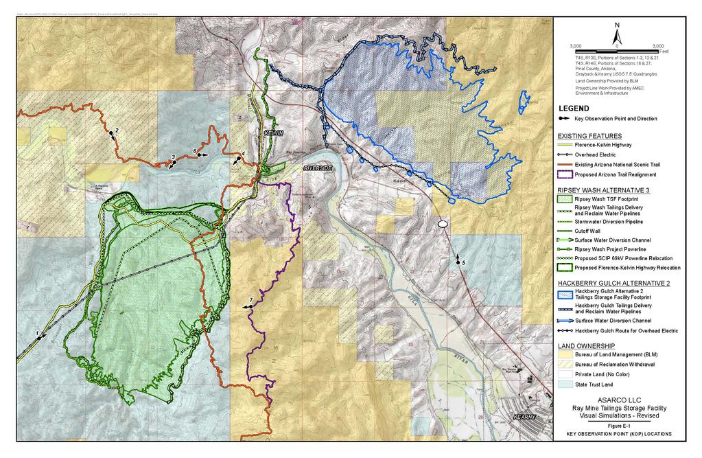
3 Visual Simulations TABLE OF CONTENTS 1. INTRODUCTION METHODOLOGY RESULTS... 3 FIGURES (follow text) Figure E-1. Figure E-2. Figure E-3. Figure E-4. Figure E-5. Figure E-6. Figure E-7. Figure E-8. Figure E-9. Figure E-10. Figure E-11. Figure E-12. Figure E-13. Figure E-14. Figure E-15. Figure E-16. Figure E-17. Figure E-18. Key Observation Point (KOP) Locations KOP 1 Florence-Kelvin Highway, Existing Condition KOP 1 Florence-Kelvin Highway, Ripsey Wash Tailings Storage Facility, Completion of Centerline Construction KOP 1 Florence-Kelvin Highway, Ripsey Wash Tailings Storage Facility, Project Completion KOP 2 Arizona Trail, Mile 4.3, Existing Condition KOP 2 Arizona Trail, Mile 4.3, Ripsey Wash Alternative 3, Completion of Centerline Construction KOP 2 Arizona Trail, Mile 4.3, Ripsey Wash Alternative 3, Project Completion KOP 3 Arizona Trail, Jake s Overlook, Existing Condition KOP 3 Arizona Trail, Jake s Overlook, Relocated Florence-Kelvin Highway & SCIP Transmission Line KOP 4 Kelvin Trail Access, Existing Condition KOP 4 Kelvin Trail Access, Relocated Florence-Kelvin Highway & SCIP Transmission Line KOP 5 State Route 177, Existing Condition KOP 5 State Route 177, Hackberry Gulch Alternative 2, Project Completion KOP 6 Arizona Trail Mile 2, Existing Condition KOP 6 Arizona Trail Mile 2, Hackberry Gulch Alternative 2, Project Completion KOP 7 Proposed AZ Trail Realignment, Existing Conditions KOP 7 Proposed AZ Trail Realignment, Ripsey Wash Tailings Storage Facility, Completion of Centerline Construction KOP 7 Proposed AZ Trail Realignment, Ripsey Wash Tailings Storage Facility, Project Completion WestLand Resources, Inc. ii Q:\Jobs\200's\203.51\ENV\09 - NEPA\Visual Simulation\Submittal \Visual Simulation Report rev docx
4 Visual Simulations 1. INTRODUCTION (Asarco) has identified the need for an additional tailings storage facility (TSF) to support ongoing mining operations at the Ray Mine in Pinal County, Arizona. The construction of an additional tailings impoundment (the Project) would require the discharge of fill to surface drainage features that have been identified as waters of the United States by the U.S. Army Corps of Engineers (Corps). An analysis of alternatives is required to demonstrate compliance with guidelines established under the Clean Water Act (CWA) Section 404(b)(1) (40 CFR 230) for avoidance and minimization of impacts to jurisdictional waters. Nine alternatives at six potential Project locations were analyzed as part of the Clean Water Act Section 404(b)(1) Alternatives Analysis prepared for the Project in accordance with the 404(b)(1) guidelines. Of the six sites considered in the Alternatives Analysis, E Dam, Devils Canyon, West Dam, and Granite Mountain were deemed impracticable and are not considered further in this investigation. The remaining two sites represent five alternatives, Ripsey Wash (Ripsey Wash Alternatives 1 to 3) and Hackberry Gulch (Hackberry Gulch Alternatives 1 and 2). Ripsey Wash Alternatives 1 and 2 and Hackberry Gulch Alternative 1 were dropped from further consideration because alternatives at these sites were developed that have fewer impacts to waters. Ripsey Wash Alternative 3 and Hackberry Gulch Alternative 2 are currently still being evaluated by Asarco (Figure E-1). Asarco has identified Ripsey Wash Alternative 3 as its proposed action in its CWA Section 404 permit application to the Corps (Corps File No. SPL MWL). The Corps identified visual resources as a topic that needed to be addressed in the Draft Environmental Impact Statement (EIS) that was released by the Corps on January 29, 2016 in accordance with the requirements of the National Environmental Policy Act. This report was initially provided July 23, 2014 to aid in the evaluation of visual impacts that would result from the construction of Ripsey Wash Alternative 3 and Hackberry Gulch Alternative 2. Asarco proposes minor changes to select project elements in response to comments on the Draft EIS. Proposed changes include the following: Realignment of the Tailings Delivery, Reclaimed Water, and Fresh Water Pipelines and Project Powerline Corridor to Reduce Greenhouse Gas Emissions Adjustment to the Florence-Kelvin Highway Realignment to Reduce Visual Impacts to the Arizona Trail Adjustment of the Relocation of the San Carlos Irrigation Project (SCIP) 64 kv Powerline Realignment to Reduce Visual Impacts to the Arizona Trail WestLand Resources, Inc. 1 Q:\Jobs\200's\203.51\ENV\09 - NEPA\Visual Simulation\Submittal \Visual Simulation Report rev docx
5 Visual Simulations Paving Portion of the Florence Kelvin Highway West of the Proposed TSF to Reduce Dust Emissions Slight Realignment of the Arizona National Scenic Trail (Arizona Trail) Relocation East of the Proposed TSF to Reduce Switchbacks to make the Trail More Sustainable and Reduce Maintenance Requirements This report also incorporates a new visual analysis point located along the proposed Arizona Trail realignment that was added per the Corps request, and presented in a supplemental visual simulation report on August 23, The information presented in this report includes a description of the methods used to prepare and present visual simulations, as well as the results of the visual simulations. 2. METHODOLOGY On December 2, 2013, Susan Corser of ECA Community Planning (ECA), as well as representatives from the Bureau of Land Management, the U.S. Forest Service, and WestLand Resources, Inc. (WestLand), met in the field near the town of Kearny, Arizona, to review and discuss possible locations for visual simulations of the Ripsey Wash and Hackberry Gulch alternatives. Based on the findings of that field work and subsequent research performed by ECA, six Key Observation Points (KOPs 1-6) were identified (Figure E-1). An additional KOP along the proposed realignment of the Arizona Trail was identified by the Corps for review in June 2017 (KOP 7, Figure E-1). On February 5, 2014, March 4, 2014, and June 13, 2017, a representative from WestLand took photos from each of the KOP s and documented the location of each photograph using a Garmin Montana 650t handheld global positioning system (GPS) unit. The camera utilized for taking photographs was a Canon Rebel XT EOS digital camera with a Canon EFS mm zoom lens. The lens was set at 33 mm to compensate for a crop factor of 1.6, thereby creating an equivalent focal length of 53 mm (33 mm lens setting x 1.6 crop factor = 52.8 mm output view), which creates a frame that mimics the field of view of the human eye. From each KOP, a series of overlapping photographs was taken of the existing landscape that would be affected by the Project. After downloading the digital images, WestLand stitched together the photographs from each photo point using Adobe Photoshop. This stitching was done by eye. The width of each panorama was dictated by the size of the visual impact that would result from the construction of the Project. Minor corrections for colors were made in order to correct for small variations between the three photos. Using ArcGIS 10.1 and 3D Analyst, WestLand merged the publicly available USGS Digital Elevation Model (DEM) (10 meter) with three-dimensional CAD data of the proposed projects provided by Asarco. The resulting DEM was then imported into AutoDesk InfoWorks (Version 2014) along with the locations of the photo points recorded by the GPS unit. WestLand rotated the DEM to correspond WestLand Resources, Inc. 2 Q:\Jobs\200's\203.51\ENV\09 - NEPA\Visual Simulation\Submittal \Visual Simulation Report rev docx
6 Visual Simulations with each photo point location and captured that digital perspective as a DEM image. The horizontal angles of these images varied between 45 to 105 degrees. Depending on the location of the KOP in relation to the Project alternatives, images that incorporated wider angles allowed for more comprehensive simulations of that Project alternative. For each photo point, the captured DEM perspective was imported into Photoshop along with the corresponding stitched panoramic image. Using recognizable existing landmarks visible in both, the DEM perspective was aligned with the panorama. The portions of the Project in the DEM image were then isolated and placed over the panoramic image. The DEM image of the Project was then rendered in Photoshop using the colors and textures that are expected to result from the Project. With respect to the printed size of the visual simulations, the simulated image was created with the intention that it be printed on 11- x 17-inch paper, to be included as a figure in the visual analysis. Visual simulations from KOPs 1, 2, 3, 4 and 7 were modified to show the adjusted Florence-Kelvin Highway realignment and adjusted SCIP powerline alignment as part of Ripsey Wash Alternative 3 as currently proposed by Asarco. 3. RESULTS Images of the existing landscapes, rendered simulations for Ripsey Wash Alternative 3 upon completion of the centerline construction and project completion, and the rendered simulations for Hackberry Gulch Alternative 2 upon project completion are presented as Figures E-2 through E-18 following this text. WestLand Resources, Inc. 3 Q:\Jobs\200's\203.51\ENV\09 - NEPA\Visual Simulation\Submittal \Visual Simulation Report rev docx
7 FIGURES
8

9 PHOTOGRAPHIC INFORMATION Time of Photograph: 2:09 PM Latitude: Date of Photograph: Longitude: Weather Condition: Mostly sunny Elevation: 2545 Viewing Direction: Northeast Distance: Not applicable Visual Simulations - Revised Figure E-2 KOP 1 Florence-Kelvin Highway Existing Condition
10 Original Visual Simulation: Revised Visual Simulation: PHOTOGRAPHIC INFORMATION Time of Photograph: 2:09 PM Latitude: Date of Photograph: Longitude: Weather Condition: Mostly sunny Elevation: 2545 Viewing Direction: Northeast Distance: 0.76 miles to nearest portion of Ripsey Wash Tailings Storage Facility Figure E-3 KOP 1 Florence-Kelvin Highway, Ripsey Wash Tailings Storage Facility, Completion of Centerline Construction KOP 1 visual simulation revised February 26, 2018 to reflect changes to proposed project alignment Note: Simulation indicates impoundment at completion of centerline construction before reclamation with rock surfacing.
11 Original Visual Simulation: Revised Visual Simulation: PHOTOGRAPHIC INFORMATION Time of Photograph: 2:09 PM Latitude: Date of Photograph: Longitude: Weather Condition: Mostly sunny Elevation: 2545 Viewing Direction: Northeast Distance: 0.76 miles to nearest portion of Ripsey Wash Tailings Storage Facility Visual Simulations Revised Figure E-4. KOP 1 Florence-Kelvin Highway Ripsey Wash Tailings Storage Facility, Project Completion KOP 1 visual simulation revised February 26, 2018 to reflect changes to proposed project alignment Note: Simulation indicates impoundment at completion of the project before reclamation of the top 30 feet of tailings and surface of the tailings.
12 PHOTOGRAPHIC INFORMATION Time of Photograph: 3:58 PM Latitude: Date of Photograph: Longitude: Weather Condition: Lightly overcast Elevation: 1897 Viewing Direction: South to southeast Distance: Not applicable Figure E-5: KOP 2 Arizona Trail, Mile 4.3 Existing Condition

13 Original Visual Simulation: Revised Visual Simulation: PHOTOGRAPHIC INFORMATION Time of Photograph: 3:58 PM Latitude: Date of Photograph: Longitude: Weather Condition: Lightly overcast Elevation: 1897 Viewing Direction: South to southeast Distance: 1.28 miles to nearest portion of Ripsey Wash Alternative 3 Figure E-6: KOP 2 Arizona Trail, Mile 4.3, Ripsey Wash Alternative 3 Completion of Centerline Construction KOP 2 visual simulation revised February 26, 2018 to reflect changes to proposed project alignment Note: Simulation indicates tailings impoundment at completion of centerline construction before reclamation with rock surfacing.
14 Original Visual Simulation: Revised Visual Simulation: PHOTOGRAPHIC INFORMATION Time of Photograph: 3:58 PM Latitude: Date of Photograph: Longitude: Weather Condition: Lightly overcast Elevation: 1897 Viewing Direction: South to southeast Distance: 1.28 miles to nearest portion of Ripsey Wash Alternative 3 Figure E-7: KOP 2 Arizona Trail, Mile 4.3, Ripsey Wash Alternative 3, Project Completion KOP 2 visual simulation revised February 26, 2018 to reflect changes to proposed project alignment Note: Simulation indicates tailings impoundment at completion of the project before reclamation of the top 30 feet of tailings.

15 PHOTOGRAPHIC INFORMATION Time of Photograph: 1:57 PM Latitude: Date of Photograph: Longitude: Weather Condition: Lightly overcast Elevation: 2128 Viewing Direction: South to southwest Distance: Not applicable Figure E-8: KOP 3 Arizona Trail, Jake s Overlook, Existing Condition
16 Original Visual Simulation: Revised Visual Simulation: PHOTOGRAPHIC INFORMATION Time of Photograph: 1:57 PM Latitude: Date of Photograph: Longitude: Weather Condition: Lightly overcast Elevation: 2128 Viewing Direction: South to southwest Distance: 0.27 miles to nearest feature of relocated highway Figure E-9: KOP 3 Arizona Trail, Jake s Overlook, Relocated Florence-Kelvin Highway & SCIP Transmission Line KOP 3 visual simulation revised February 26, 2018 to reflect changes to proposed project alignment
17 PHOTOGRAPHIC INFORMATION Time of Photograph: 11:55 AM Latitude: Date of Photograph: Longitude: Weather Condition: Lightly overcast Elevation: 1795 Viewing Direction: Southwest Distance: Not applicable Figure E-10: KOP 4 Kelvin Trail Access, Existing Condition

18 Original Visual Simulation: Revised Visual Simulation: PHOTOGRAPHIC INFORMATION Time of Photograph: 11:55 AM Latitude: Date of Photograph: Longitude: Weather Condition: Lightly overcast Elevation: 1795 Viewing Direction: Southwest Distance: 0.71 miles to nearest visible section of relocated highway Figure E-11: KOP 4 Kelvin Trial Access, Relocated Florence-Kelvin Highway & SCIP Transmission Line KOP 4 visual simulation revised February 26, 2018 to reflect changes to proposed project alignment

19 PHOTOGRAPHIC INFORMATION Time of Photograph: PM Latitude: Date of Photograph: Longitude: Weather Condition: Lightly overcast Elevation: 2030 Viewing Direction: North Distance: Not applicable Figure E-12: KOP 5 State Route 177 Existing Condition
20 PHOTOGRAPHIC INFORMATION Time of Photograph: PM Latitude: Date of Photograph: Longitude: Weather Condition: Lightly overcast Elevation: 2030 Viewing Direction: North Distance: 0.85 miles to nearest portion of Hackberry Gulch Alternative 2 Visual Simulations Figure E-13: KOP 5 State Route 177, Hackberry Gulch Alternative 2, Project Completion Note: Simulation indicates tailings impoundment at completion of the project before reclamation of the top 30 feet of the tailings.
21 PHOTOGRAPHIC INFORMATION Time of Photograph: 1:21 PM Latitude: Date of Photograph: Longitude: Weather Condition: Lightly overcast Elevation: 2037 Viewing Direction: East Distance: Not applicable Figure E-14: KOP 6 Arizona Trail, Mile 2 Existing Condition

22 PHOTOGRAPHIC INFORMATION Time of Photograph: 1:21 PM Latitude: Date of Photograph: Longitude: Weather Condition: Lightly overcast Elevation: 2037 Viewing Direction: East Distance: 1.87 miles to nearest portion of Hackberry Gulch Alternative 2 Figure E-15: KOP 6 Arizona Trail, Mile 2, Hackberry Gulch Alternative 2 Project Completion Note: Simulation indicates tailings impoundment at completion of the project before reclamation of the top 30 feet of the tailings.

23 PHOTOGRAPHIC INFORMATION Time of Photograph: 9:42 AM Latitude: Date of Photograph: Longitude: Weather Condition: Mostly sunny Elevation: 2992 Viewing Direction: West Distance: Not applicable Figure E-16. KOP 7 Proposed AZ Trail Realignment Existing Conditions

24 PHOTOGRAPHIC INFORMATION Time of Photograph: 9:42 AM Latitude: Date of Photograph: Longitude: Weather Condition: Mostly sunny Elevation: 2992 Viewing Direction: West Distance: 0.40 miles to nearest portion of Ripsey Wash Tailings Storage Facility Figure E-17. KOP 7 Proposed AZ Trail Realignment Ripsey Wash Tailings Storage Facility, Completion of Centerline Construction Note: Simulation indicates impoundment at completion of centerline construction before reclamation with rock surfacing.

25 PHOTOGRAPHIC INFORMATION Time of Photograph: 9:42 AM Latitude: Date of Photograph: Longitude: Weather Condition: Mostly sunny Elevation: 2992 Viewing Direction: West Distance: 0.40 miles to nearest portion of Ripsey Wash Tailings Storage Facility Figure E-18. KOP 7 Proposed AZ Trail Realignment Ripsey Wash Tailings Storage Facility, Project Completion Note: Simulation indicates impoundment at completion of the project before reclamation of the top 30 feet of tailings and surface of the tailings.
APPENDIX E - VISUAL SIMULATIONS
 APPENDIX E - VISUAL SIMULATIONS VISUAL SIMULATIONS RAY MINE TAILINS STORAE FACILITY Prepared for: U.S. Army Corps of Engineers Prepared by: 4001 E. Paradise Falls Drive Tucson, Arizona 85712 On behalf
Northern Pass. Transmission Project: Visual Simulations. The THE NORTHERN PASS SM. MAY 2011_v2
 The Northern Pass Transmission Project: Visual Simulations THE NORTHERN PASS SM Northern Pass PO Box 330 780 North Commercial Street Manchester, NH 03105-0330 800-286-7305 www.northernpass.us MAY 2011_v2
VISUAL RESOURCE EVALUATION PROPOSED ATTACHED WIRELESS TELECOMMUNICATIONS INSTALLATION
 VISUAL RESOURCE EVALUATION PROPOSED ATTACHED WIRELESS TELECOMMUNICATIONS INSTALLATION 965 ANDERSON HILL ROAD RYE BROOK WESTCHESTER COUNTY NEW YORK Submitted by: 175 Calkins Road Rochester, NY 14623 Prepared
GEORGE M. JANES & ASSOCIATES. September 4, Ted Fink Greenplan 302 Pells Rd. Rhinebeck, NY 12572
 GEORGE M. JANES & ASSOCIATES PLANNING with TECHNOLOGY 250 EAST 87TH STREET NEW YORK, NY 10128 www.georgejanes.com September 4, 2008 Ted Fink Greenplan 302 Pells Rd. Rhinebeck, NY 12572 T: 917.612.7478
Creating a Panorama Photograph Using Photoshop Elements
 Creating a Panorama Photograph Using Photoshop Elements Following are guidelines when shooting photographs for a panorama. Overlap images sufficiently -- Images should overlap approximately 15% to 40%.
How to combine images in Photoshop
 How to combine images in Photoshop In Photoshop, you can use multiple layers to combine images, but there are two other ways to create a single image from mulitple images. Create a panoramic image with
SPECIAL PUBLIC NOTICE
 SPECIAL PUBLIC NOTICE Draft Map and Drawing Standards for the South Pacific Division Regulatory Program March 5, 2012 Comment period: ends April 5, 2012 Corps contact: Thomas Cavanaugh (415) 503-6574 (Thomas.J.Cavanaugh@usace.army.mil)
WEEKS STATE PARK - EAST OVERLOOK, LANCASTER EXISTING CONDITIONS: PANORAMA (FACING EAST)
") EXISTING CONDITIONS: PANORAMA (FACING EAST) Parking area and lookout at East Overlook on Mount Prospect Road. LOCATION MAP! TECHNICAL INFORMATION EXISTING PROPOSED 115-kV structure type Wood H-Frame Weathering
EXISTING CONDITIONS: PANORAMA (FACING EAST) Parking area and lookout at East Overlook on Mount Prospect Road. LOCATION MAP! TECHNICAL INFORMATION EXISTING PROPOSED 115-kV structure type Wood H-Frame Weathering
SPECIAL PUBLIC NOTICE
 SPECIAL PUBLIC NOTICE Draft Map and Drawing Standards for the South Pacific Division Regulatory Program August 6, 2012 Corps contacts: Sacramento District: Michael Finan (916) 557-5324 (Michael.C.Finan@usace.army.mil)
RAPTOR SURVEYS CONDUCTED AT NEAR WEST 2013 RESOLUTION COPPER MINING
 RAPTOR SURVEYS CONDUCTED AT NEAR WEST 2013 RESOLUTION COPPER MINING Prepared for: 102 Magma Heights PO Box 1944 Superior, Arizona 85173 Prepared by: 4001 E Paradise Falls Drive Tucson, Arizona 85712 April
3.0 AFFECTED ENVIRONMENT
 3.0 AFFECTED ENVIRONMENT 3.1 Visual Resources This section provides a discussion of the existing visual resources in the vicinity of the Imperial Valley Solar Energy Center South project site that could
Location Verification: Siting Tyson s 1863 Photograph of Camp Letterman General Hospital
 Location Verification: Siting Tyson s 1863 Photograph of Camp Letterman General Hospital Tom Danninger Gettysburg Magazine, Number 52, January 2015, pp. 46-51 (Article) Published by University of Nebraska
Appendix N. Haile Gold Mine EIS Supporting Information and Analysis for Visual Resources Assessment
 Appendix N Supporting Information and Analysis for Visual Resources Assessment This page is left blank intentionally. Table of Contents Page N. Methodology for Identification of Key Observation Points
Marmot & Little Sandy Dam Removal
 Marmot & Little Sandy Dam Removal Final Report August 2009 Bruce McCammon Photography 10691 NW Harding Ct. Portland, OR 97229 www.bpmphotography.com Contract Number AG-046W-P-07-0099 Contents Introduction...
RAF DRAFT. Viewpoint 11: Taken from a road within Burlescombe, looking oking south-west towards the site.
 St. Mary s Church (Grade I listed) Viewpoint 11: Taken from a road within Burlescombe, looking oking south-west towards the site. RAF Approximate location of the site obscured by existing conifers FT Viewpoint
QUALITY ASSURANCE/QUALITY CONTROL DOCUMENTATION SERIES SITE SELECTION FOR SCENE MONITORING EQUIPMENT STANDARD OPERATING PROCEDURE
 QUALITY ASSURANCE/QUALITY CONTROL DOCUMENTATION SERIES TITLE SITE SELECTION FOR SCENE MONITORING EQUIPMENT TYPE STANDARD OPERATING PROCEDURE NUMBER 4055 DATE DECEMBER 1993 AUTHORIZATIONS TITLE NAME SIGNATURE
[LLORW00000.L ER0000.LVRWH09H XL5017AP.WAOR Notice of Availability of the Record of Decision for the Proposed Vantage to
 This document is scheduled to be published in the Federal Register on 01/18/2017 and available online at https://federalregister.gov/d/2017-01000, and on FDsys.gov 4310-33 DEPARTMENT OF THE INTERIOR Bureau
Introduction to Panoramic photography. David R. Chung Linn Area Photography Club
 Introduction to Panoramic photography David R. Chung http://www.dchung.com Linn Area Photography Club 1. What is a panoramic photograph? 2. Why panoramas? 3. Techniques 4. In the field 5. In the digital
[LLNVW00000.L GN0000.LVEMF X. Notice of Intent to Prepare an Environmental Impact Statement for the Proposed
 This document is scheduled to be published in the Federal Register on 03/04/2016 and available online at http://federalregister.gov/a/2016-04806, and on FDsys.gov 4310-HC DEPARTMENT OF THE INTERIOR Bureau
Site Plan/Building Permit Review
 Part 6 Site Plan/Building Permit Review 1.6.01 When Site Plan Review Applies 1.6.02 Optional Pre- Application Site Plan/Building Permit Review (hereafter referred to as Site Plan Review) shall be required
[LLNVB01000.L EX0000.LVTFF15F6810 MO# ] Notice of Intent to Prepare an Environmental Impact Statement for the Proposed
![[LLNVB01000.L EX0000.LVTFF15F6810 MO# ] Notice of Intent to Prepare an Environmental Impact Statement for the Proposed](/thumbs/87/96336676.jpg "[LLNVB01000.L EX0000.LVTFF15F6810 MO# ] Notice of Intent to Prepare an Environmental Impact Statement for the Proposed") This document is scheduled to be published in the Federal Register on 09/29/2015 and available online at http://federalregister.gov/a/2015-24432, and on FDsys.gov 4310-HC DEPARTMENT OF THE INTERIOR Bureau
This document is scheduled to be published in the Federal Register on 09/29/2015 and available online at http://federalregister.gov/a/2015-24432, and on FDsys.gov 4310-HC DEPARTMENT OF THE INTERIOR Bureau
Movie 10 (Chapter 17 extract) Photomerge
 Photomerge") Movie 10 (Chapter 17 extract) Adobe Photoshop CS for Photographers by Martin Evening, ISBN: 0 240 51942 6 is published by Focal Press, an imprint of Elsevier. The title will be available from early February
Movie 10 (Chapter 17 extract) Adobe Photoshop CS for Photographers by Martin Evening, ISBN: 0 240 51942 6 is published by Focal Press, an imprint of Elsevier. The title will be available from early February
Aperture & ƒ/stop Worksheet
 Tools and Program Needed: Digital C. Computer USB Drive Bridge PhotoShop Name: Manipulating Depth-of-Field Aperture & stop Worksheet The aperture setting (AV on the dial) is a setting to control the amount
Appendix 8.2 Information to be Read in Conjunction with Visualisations
 Shepherds Rig Wind Farm EIA Report Appendix 8.2 Information to be Read in Conjunction with Visualisations Contents Contents i Introduction 1 Viewpoint Photography 1 Stitching of Panoramas and Post-Photographic
Repeat Photography using GigaPan Imagery in the San Simon Watershed, Arizona, USA
 Carnegie Mellon University Research Showcase @ CMU Fine International Conference on Gigapixel Imaging for Science Conferences and Events 11-2010 Repeat Photography using GigaPan Imagery in the San Simon
GEORGE M. JANES & ASSOCIATES. July 12, Sabrina Charney-Hull Planning Director Town of New Castle 200 South Greeley Avenue Chappaqua, NY 10514
 GEORGE M. JANES & ASSOCIATES PLANNING with TECHNOLOGY 250 EAST 87TH STREET NEW YORK, NY 10128 www.georgejanes.com T: 646.652.6498 F: 801.457.7154 E: george@georgejanes.com July 12, 2012 Sabrina Charney-Hull
Checklist for Minor Plan Modification
 Checklist for Minor Plan Modification All submittal information shall be provided to the Community Development Department. All submittal information shall be presented along with the Uniform Application,
Exit 61 I-90 Interchange Modification Justification Study
 Exit 61 I-90 Interchange Modification Justification Study Introduction Exit 61 is a diamond interchange providing the connection between Elk Vale Road and I-90. Figure 1 shows the location of Exit 61.
How I did it by Chris Axe. Special thanks to Kim Walker
 How I did it by Chris Axe Special thanks to Kim Walker Story of this image This photo was taken in Garrapata State Park at the very first gate as you head south. It took about 15 minutes to figure out
Grading, Erosion and Sediment Control (GESC) Checklist
 Checklist") Development Services Department 100 N. Wilcox Street, Castle Rock CO 80104 Planner of the Day 303-660-1393 Grading, Erosion and Sediment Control (GESC) Checklist A complete Grading, Erosion and Sediment
Development Services Department 100 N. Wilcox Street, Castle Rock CO 80104 Planner of the Day 303-660-1393 Grading, Erosion and Sediment Control (GESC) Checklist A complete Grading, Erosion and Sediment
CHAPTER 2 SUBMITTAL AND REVIEW PROCEDURES TABLE OF CONTENTS
 CHAPTER 2 SUBMITTAL AND REVIEW PROCEDURES TABLE OF CONTENTS Section Title Page 2.1 General... 2-1 2.1.1 General Submittal Criteria and Procedures...2-1 2.1.2 Authorization/Certification...2-1 A. Designer
Panoramic Photography
 Panoramic Photography By: W. Patrick Day Patrick@PatrickDayPhotography.com Panoramic Photography What is Panoramic photography? a technique, using specialized equipment or software, that captures images
Panoramic Photo Stitching Tutorial
 Panoramic Photo Stitching Tutorial What is Photo Stitching? If you have ever shot photos on film, you might have already tried photostitching at one point or another. You would have taken 4 or 5 images
Digital Design and Communication Teaching (DiDACT) University of Sheffield Department of Landscape. Adobe Photoshop CS4 INTRODUCTION WORKSHOPS
 University of Sheffield Department of Landscape. Adobe Photoshop CS4 INTRODUCTION WORKSHOPS") Adobe Photoshop CS4 INTRODUCTION WORKSHOPS WORKSHOP 3 - Creating a Panorama Outcomes: y Taking the correct photographs needed to create a panorama. y Using photomerge to create a panorama. y Solutions
Adobe Photoshop CS4 INTRODUCTION WORKSHOPS WORKSHOP 3 - Creating a Panorama Outcomes: y Taking the correct photographs needed to create a panorama. y Using photomerge to create a panorama. y Solutions
Digital camera modes explained: choose the best shooting mode for your subject
 Digital camera modes explained: choose the best shooting mode for your subject On most DSLRs, the Mode dial is split into three sections: Scene modes (for doing point-and-shoot photography in specific
Which equipment is necessary? How is the panorama created?
 Congratulations! By purchasing your Panorama-VR-System you have acquired a tool, which enables you - together with a digital or analog camera, a tripod and a personal computer - to generate high quality
Yavapai County Development Services
 Yavapai County Development Services Prescott Office 1120 Commerce Dr., Prescott, AZ 86305 (928) 771-3214 Fax: (928) 771-3432 Cottonwood Office 10 S. 6 th Street, Cottonwood, AZ 86326 (928) 639-8151 Fax:
Panoramas. Featuring ROD PLANCK. Rod Planck DECEMBER 29, 2017 ADVANCED
 DECEMBER 29, 2017 ADVANCED Panoramas Featuring ROD PLANCK Rod Planck D700, PC-E Micro NIKKOR 85mm f/2.8d, 1/8 second, f/16, ISO 200, manual exposure, Matrix metering. When we asked the noted outdoor and
Background Ambient Noise Study Rosemont Copper
 Background Ambient Noise Study Rosemont Copper Prepared for: Rosemont Copper 40 Cherry Creek South Drive, Ste. 10 Denver, Colorado 246 (3) 0-0138 Fax (3) 0-0135 Prepared by: 31 West Ina Road Tucson, Arizona
Presented by Craig Stocks Arts by Craig Stocks Arts
 Presented by Craig Stocks Arts www.craigstocksarts.com 2010 by Craig Stocks Arts Basic camera settings for point and shoot cameras (resolution, quality) Resolution - how much can you enlarge a picture?
MINIMUM DRAWING REQUIREMENTS FOR WATER AND SEWER LINE PROJECTS
 Public Works Department Water & Wastewater Services WATER & WASTEWATER ENGINEERING DIVISION 2555 West Copans Road Pompano Beach, Florida 33369 954-831-0745 FAX 954-831-0798/0925 MINIMUM DRAWING REQUIREMENTS
Pre-Construction Sound Study. Velco Jay Substation DRAFT. January 2011 D A T A AN AL Y S IS S OL U T I ON S
 Pre-Construction Sound Study Substation DRAFT January 2011 D A T A AN AL Y S IS S OL U T I ON S TABLE OF CONTENTS 1.0 INTRODUCTION...1 2.0 SOUND LEVEL MONITORING...1 3.0 SOUND MODELING...4 3.1 Modeling
SECTION 100 PRELIMINARY CONSIDERATIONS & INSTRUCTIONS
 SECTION 100 PRELIMINARY CONSIDERATIONS & INSTRUCTIONS 101 General 102 Submittal Requirements A. Initial Submittal B. Second Submittal 103 Plan Requirements A. Subdivisions B. Site Plans 104 Approval of
MASSACHUSETTS INSTITUTE OF TECHNOLOGY HAYSTACK OBSERVATORY WESTFORD, MASSACHUSETTS
 EDGES MEMO #012 RFI MEMO #027 MASSACHUSETTS INSTITUTE OF TECHNOLOGY HAYSTACK OBSERVATORY WESTFORD, MASSACHUSETTS 01886 November 2, 2006 Telephone: 781-981-5407 Fax: 781-981-0590 To: RFI Group From: Judd
BRASELTON WATER AND WASTEWATER DEPARTMENT CONSTRUCTION PLAN REVIEW CHECKLIST May 2006
 Project Name: BRASELTON WATER AND WASTEWATER DEPARTMENT CONSTRUCTION PLAN REVIEW CHECKLIST May 2006 Phase: Unit: # Lots: Development Type (residential, commercial, industrial, etc.) Braselton Project No.
Work Plan for Pre-Construction Avian and Bat Surveys
 Work Plan for Pre-Construction Avian and Bat Surveys, Steuben County, New York Prepared For: EverPower Wind Holdings, Inc. 1251 Waterfront Place, 3rd Floor Pittsburgh, PA 15222 Prepared By: Stantec Consulting
Black. LWECS Site Permit. Stearns County. Permit Section:
 PERMIT COMPLIANCE FILING Permittee: Permit Type: Project Location: Docket No: Permit Section: Date of Submission : Black Oak Wind,, LLC LWECS Site Permit Stearns County IP6853/WS-10-1240 and IP6866/WS-11-831
MINNESOTA DEPARTMENT OF TRANSPORTATION OFFICE OF LAND MANAGEMENT SURVEYING AND MAPPING SECTION PHOTOGRAMMETRY UNIT
 SEP. 2011 MINNESOTA DEPARTMENT OF TRANSPORTATION OFFICE OF LAND MANAGEMENT SURVEYING AND MAPPING SECTION PHOTOGRAMMETRY UNIT SPECIAL PROVISIONS FOR: GROUP 1: AERIAL PHOTOGRAPHY/PHOTOGRAMMETRIC LAB SERVICES
HDD Wire Guided Waterway Crossing ATON Plan. Youghiogheny River (S122)
") HDD Wire Guided Waterway Crossing ATON Plan Youghiogheny River (S122) Mariner East Phase 2 Pipeline Project Prepared for: Sunoco Pipeline, L.P. 535 Friztown Road Sinking Springs, PA 19608 Prepared by:
HDD Wire Guided Waterway Crossing ATON Plan Youghiogheny River (S122) Mariner East Phase 2 Pipeline Project Prepared for: Sunoco Pipeline, L.P. 535 Friztown Road Sinking Springs, PA 19608 Prepared by:
Map and Drawing Standards for the South Pacific Division Regulatory Program
 Map and Drawing Standards for the South Pacific Division Regulatory Program Hollis Jencks Project Manager, Nevada/Utah Section Sacramento District Regulatory Program Workshop 31 May 2018 US Army Corps
Operating Standards Attachment to Development Application
 Planning & Development Services 2255 W Berry Ave. Littleton, CO 80120 Phone: 303-795-3748 Mon-Fri: 8am-5pm www.littletongov.org Operating Standards Attachment to Development Application 1 SKETCH PLANS
Instructions for Use of Resolution Chart
 Camera & Imaging Products Association Instructions for Use of Resolution Chart 1. Introduction Thank you very much for your purchase of this resolution chart for digital still cameras. This resolution
Survey for Crested Caracara (Caracara cheriway) Nests on Santa Cruz Flats, Pinal County, March 23, 2013 Doug Jenness and Rich Glinski
 Nests on Santa Cruz Flats, Pinal County, March 23, 2013 Doug Jenness and Rich Glinski") Survey for Crested Caracara (Caracara cheriway) Nests on Santa Cruz Flats, Pinal County, March 23, 2013 Doug Jenness and Rich Glinski Introduction The number of Crested Caracaras has been increasing in
Survey for Crested Caracara (Caracara cheriway) Nests on Santa Cruz Flats, Pinal County, March 23, 2013 Doug Jenness and Rich Glinski Introduction The number of Crested Caracaras has been increasing in
UTILITY SERVICE/REPAIR PERMIT
 Form M-21 Revised: September TRANSPORTATION COMMISSION OF WYOMING and its UTILITY SERVICE/REPAIR PERMIT 1. Parties. The parties to this License are, hereinafter referred to as Permittee, whose address
VISUALISATION STANDARDS
 VISUALISATION STANDARDS INTRODUCTION These standards have been produced to enable the Council to verify that photomontages submitted in support of planning applications and contained with Environmental
Advanced Diploma in. Photoshop. Summary Notes
 Advanced Diploma in Photoshop Summary Notes Suggested Set Up Workspace: Essentials or Custom Recommended: Ctrl Shift U Ctrl + T Menu Ctrl + I Ctrl + J Desaturate Free Transform Filter options Invert Duplicate
City of San José, California CITY COUNCIL POLICY
 City of San José, California CITY COUNCIL POLICY TITLE 1 1 of 6 EFFECTIVE DATE 1/22/91 REVISED DATE 9/16/03 APPROVED BY Council Action - January 22, 1991; August 11, 1992; August 20, 1996 (9d); September
31, The following isoline map shows the variations in the relative strength of Earth's magnetic field from 1 (strong) to 11 (weak).
 to 11 (weak).") 31, The following isoline map shows the variations in the relative strength of Earth's magnetic field from 1 (strong) to 11 (weak). 33. The following four temperature field maps represent the same region
31, The following isoline map shows the variations in the relative strength of Earth's magnetic field from 1 (strong) to 11 (weak). 33. The following four temperature field maps represent the same region
Introduction to Aerial Photographs and Topographic maps (Chapter 3)
") GEOLOGY 306 Laboratory Instructor: TERRY J. BOROUGHS NAME: Introduction to Aerial Photographs and Topographic maps (Chapter 3) For this assignment you will require: a calculator and metric ruler. Objectives:
GEOLOGY 306 Laboratory Instructor: TERRY J. BOROUGHS NAME: Introduction to Aerial Photographs and Topographic maps (Chapter 3) For this assignment you will require: a calculator and metric ruler. Objectives:
PLANNING AND DEVELOPMENT
 OVERVIEW Effective January 1, 1992 all applications for multi-family residential and all non-residential building permits require site plan approval before permit issuance. All new developments and existing
Capturing Realistic HDR Images. Dave Curtin Nassau County Camera Club February 24 th, 2016
 Capturing Realistic HDR Images Dave Curtin Nassau County Camera Club February 24 th, 2016 Capturing Realistic HDR Images Topics: What is HDR? In Camera. Post-Processing. Sample Workflow. Q & A. Capturing
Notice of Intent to Prepare a Master Leasing Plan, Amendments to the Resource
 4310-DQ-P DEPARTMENT OF THE INTERIOR Bureau of Land Management (LLUTY01000.L16100000.DP0000) Notice of Intent to Prepare a Master Leasing Plan, Amendments to the Resource Management Plans for the Moab
of a Panoramic Image Scene
 US 2005.0099.494A1 (19) United States (12) Patent Application Publication (10) Pub. No.: US 2005/0099494A1 Deng et al. (43) Pub. Date: May 12, 2005 (54) DIGITAL CAMERA WITH PANORAMIC (22) Filed: Nov. 10,
State College Area School District
 State College Area School District The following is a guideline for project design submittals to the Facility Committee of the State College Area School District. During the design process the committee
PROCESSING LANDSCAPES
 PROCESSING LANDSCAPES Mist in the Hope Valley Mam Tor, Peak District, taken 23 January 2017 LANDSCAPE IMAGES - AIMS Good composition (Use the Rule of Thirds if possible). Consider a low viewpoint. A feeling
Appendix 6-F: Electric and Magnetic Field Study Report
 Draft Environmental Impact Statement Cricket Valley Energy Project Dover, NY Appendix 6-F: Electric and Magnetic Field Study Report ELECTRIC & MAGNETIC FIELDS (EMFs) STUDY REPORT For the CRICKET VALLEY
Plan Submittal and Review Checklist
 Improving quality of life today creating a better tomorrow Plan Submittal and Review Checklist Version 1.2 September 4, 2017 Contents Overview... 2 Plan Submittal Checklist... 2 Plan Review Checklist -
Cloud Image Project 1. Grant Meaux. Flow Visualization. Professor Jean Hertzberg. March 4, 2011
 Cloud Image Project 1 Grant Meaux Flow Visualization Professor Jean Hertzberg March 4, 2011 The intent of this cloud photograph is to observe and capture the dynamics of a cloud formation as a fluid flow,
Appendix K.3 Attachment 2: Photographic Record of Exempt Earthen Channel Segments
 Appendix K.3 Attachment 2: Photographic Record of Exempt Earthen Channel Segments i Appendix I.3 Attachment 2: of Exempt Earthen Channel Segments Site Name: North Creek Photograph 1 North Photograph 2
CITY OF EL MIRAGE DEVELOPMENT APPLICATION PROCESS
 DEVELOPMENT APPLICATION PROCESS Development Applications are reviewed by the El Mirage Technical Advisory Committee (TAC) to ensure Building, Engineering and Zoning compliance before scheduling public
ONE OF THE MOST IMPORTANT SETTINGS ON YOUR CAMERA!
 Chapter 4-Exposure ONE OF THE MOST IMPORTANT SETTINGS ON YOUR CAMERA! Exposure Basics The amount of light reaching the film or digital sensor. Each digital image requires a specific amount of light to
Polarizers, how they work, when to use them, how to use them...
 Polarizers, how they work, when to use them, how to use them... Author's Note: This is a slightly updated version of an article on Polarization that Singh-Ray asked me to write several years ago. During
Appendix G. Visual Simulations and Illustrations
 Appendix G Visual Simulations and Illustrations 5TH AVE AV E N View ewshe ed 5 SHORELINE N 185TH ST egment B gment A 26 NE 185th Street Station (A1, A3, A5, A7, A10, A11) 25 24 23 22 21 NE 180TH ST 99
Oakland County Michigan Register of Deeds Plat Engineering, GIS, & Remonumentation Dept. Ph: (248) Fax (248)
 Fax (248)") Oakland County Michigan Register of Deeds Plat Engineering, GIS, & Remonumentation Dept. Ph: (248)-858-1447 Fax (248)-858-7466 Requirements Needed for Final Condominium Approval General Requirements. 1
Oakland County Michigan Register of Deeds Plat Engineering, GIS, & Remonumentation Dept. Ph: (248)-858-1447 Fax (248)-858-7466 Requirements Needed for Final Condominium Approval General Requirements. 1
Photoshop Elements 3 Panoramas
 Photoshop Elements 3 Panoramas One of the good things about digital photographs and image editing programs is that they allow us to stitch two or three photographs together to create one long panoramic
Electric Service Guide. Residential Subdivision
 Electric Service Guide Residential Subdivision January 1, 2017 Contact MID s Electric Engineering Department (electric.standards@mid.org) with any questions about this Service Guide. Check MID s website
Work Type Definition and Submittal Requirements Work Type: Subsurface Utility Engineering (SUE)
") MUST be qualified under Minnesota Department of Transportation Prequalification Program - Work Type 15.1 Subsurface Utility Engineering The first section, Work Type Definition, provides a detailed explanation
MUST be qualified under Minnesota Department of Transportation Prequalification Program - Work Type 15.1 Subsurface Utility Engineering The first section, Work Type Definition, provides a detailed explanation
Technical Memorandum ECO-7
 To: Woody Frossard, TRWD From: Bob Brashear, CDM This document is released for the purpose of interim review under the authority of Robert Brashear, P.E., TX license 80771 on 21-Mar-2005. It is not to
HDR Show & Tell Image / Workflow Review Session. Dave Curtin Nassau County Camera Club October 3 rd, 2016
 HDR Show & Tell Image / Workflow Review Session Dave Curtin Nassau County Camera Club October 3 rd, 2016 Capturing Realistic HDR Images Topics: HDR Review (Brief Summary from HDR Presentation Parts: 1
Minimum Drawing & Electronic Submittal Requirements For Record Drawings /As-Builts
 Minimum Drawing & Electronic Submittal Requirements For Record Drawings /As-Builts PUBLIC WORKS ENGINEERING DEPARTMENT Revised: February 1, 2017 MINIMUM DRAWING REQUIREMENTS A. GENERAL PLAN REQUIREMENTS:
North Fork Alternative Plan Executive Summary
 North Fork Alternative Plan Executive Summary The North Fork Alternative Plan (NFAP) is a resource-based set of recommendations provided to the U.S. Bureau of Land Management (BLM) as guidance regarding
Proposed Kumototo Site 10 Wellington
 Proposed Kumototo Site 10 Wellington Visualisation Simulation Methodology - Buildmedia Limited Contents 1.0 Introduction 2.0 Process Methodology Kumototo Site 10 Visual Simulation 3.0 Conclusion 1.0 Introduction
BGRI Stem Rust Survey Protocol. Overview of Field Survey Procedure
 Overview of Field Survey Procedure 1. Ensure survey team have all items on check-list before departure 2. Travel to 1 st survey location 3. At survey location switch on GPS 4. Wait until GPS receives satellite
Appendix B. Airport Master Plan Update William R. Fairchild International Airport Port Angeles, Washington AIRPORT LAYOUT PLAN CHECKLIST
 APPENDICES Appendix B AIRPORT LAYOUT PLAN CHECKLIST 3 Airport Master Plan Update William R. Fairchild International Airport Port Angeles, Washington September 2011 AC 150/5070-6B (incl. Chg. 1, 5/1/07)
VAR Generator Operation for Maintaining Network Voltage Schedules
 Standard Development Timeline This section is maintained by the drafting team during the development of the standard and will be removed when the standard becomes effective. Development Steps Completed
Stitching panorama photographs with Hugin software Dirk Pons, New Zealand
 Stitching panorama photographs with Hugin software Dirk Pons, New Zealand March 2018. This work is made available under the Creative Commons license Attribution-NonCommercial 4.0 International (CC BY-NC
>--- UnSorted Tag Reference [ExifTool -a -m -u -G -sort ] ExifTool Ver: 10.07
![>--- UnSorted Tag Reference [ExifTool -a -m -u -G -sort ] ExifTool Ver: 10.07](/thumbs/96/126583196.jpg ">--- UnSorted Tag Reference [ExifTool -a -m -u -G -sort ] ExifTool Ver: 10.07") From Image File C:\AEB\RAW_Test\_MG_4376.CR2 Total Tags = 433 (Includes Composite Tags) and Duplicate Tags >------ SORTED Tag Position >--- UnSorted Tag Reference [ExifTool -a -m -u -G -sort ] ExifTool
From Image File C:\AEB\RAW_Test\_MG_4376.CR2 Total Tags = 433 (Includes Composite Tags) and Duplicate Tags >------ SORTED Tag Position >--- UnSorted Tag Reference [ExifTool -a -m -u -G -sort ] ExifTool
Image stitching. Image stitching. Video summarization. Applications of image stitching. Stitching = alignment + blending. geometrical registration
 Image stitching Stitching = alignment + blending Image stitching geometrical registration photometric registration Digital Visual Effects, Spring 2006 Yung-Yu Chuang 2005/3/22 with slides by Richard Szeliski,
SUBMITTAL REQUIREMENTS RCV D REJECT PENDING
 1 of 5 SUBMITTAL REQUIREMENTS RCV D REJECT PENDING 1. General Information. 1.1 Applicant s name, address and contact numbers. 1.2 Project name, type, address and legal description of the property. 1.3
Plan Preparation Checklist
 Appendix D Plan Preparation Checklist It is the responsibility of the Designer to complete and submit this checklist along with all required drawings for OUC (EFP) Review. All drawings submitted for OUC
Green Cay Nature Center and Wetlands 8 th Annual Photo Contest Sponsored by the Friends of Green Cay Nature Center, Inc.
 Green Cay Nature Center and Wetlands 8 th Annual Photo Contest Sponsored by the Friends of Green Cay Nature Center, Inc. CONTEST RULES ENTRY DEADLINE FEBRUARY 13, 2017 Entries will be accepted from January
PlanIt! for Photographers ALL-IN-ONE PLANNING APP FOR LANDSCAPE PHOTOGRAPHERS QUICK USER GUIDES
 PlanIt! for Photographers ALL-IN-ONE PLANNING APP FOR LANDSCAPE PHOTOGRAPHERS QUICK USER GUIDES User Interface Overview Title Bar Ephemeris Pager Page Indicator Info Window Scene Pin Map with Info Overlay
Contents. Acknowledgments. Map. Passage to Wonderland 1. J. E. Stimson, Photography, Rephotography, and Me 7
 Contents Acknowledgments ix Map xiv 1 Passage to Wonderland 1 J. E. Stimson, Photography, Rephotography, and Me 7 2 History of the Cody Road to Yellowstone 29 3 Photographs and Rephotographs 51 4 Afterword
CALL TO ARTISTS DOWNTOWN SYLVA MURAL PROJECT SYLVA, NORTH CAROLINA
 CALL TO ARTISTS DOWNTOWN SYLVA MURAL PROJECT SYLVA, NORTH CAROLINA The Town of Sylva and the Sylva Public Art Committee invite artists or artist teams to submit qualifications for an artist to develop
Photograph #2: 11/29/12 Area 1, view facing northeast.
 Photograph #1: 11/29/12 Area 1,view facing southwest. Photograph #2: 11/29/12 Area 1, view facing northeast. 10404-03 Draft Final Supplemental Remedial Investigation #2 Page 1 of 25 June 2013 Photograph
UNITED STATES DEPARTMENT OF THE INTERIOR BUREAU OF LAND MANAGEMENT WASHINGTON, D.C October 23, 2003
 UNITED STATES DEPARTMENT OF THE INTERIOR BUREAU OF LAND MANAGEMENT WASHINGTON, D.C. 20240 October 23, 2003 EMS TRANSMISSION 10/23/2003 Instruction Memorandum No. 2003-275 Change 1 Expires: 09/30/2004 In
Radio Frequency Engineering Report. Proposed Raymond, ME Cellular Facility
 Radio Frequency Engineering Report Proposed, ME Cellular Facility (Site No.: 3462 ) May 12, 2010 C Squared Systems, LLC 920 Candia Road Manchester, NH 03109 Phone: (603) 657-9702 Fax: (603) 657-9707 Support@csquaredsystems.com
The Fish-eye Lens In Landscape Photography by E.J. Peiker
 The Fish-eye Lens In Landscape Photography by E.J. Peiker The fish-eye lens has long been a novelty lens that allows photographers to explore a unique look and perspective in their photographic endeavors.
Term 1 Study Guide for Digital Photography
 Name: Period Term 1 Study Guide for Digital Photography History: 1. The first type of camera was a camera obscura. 2. took the world s first permanent camera image. 3. invented film and the prototype of
FREMONT COUNTY. APPLICATION FOR ZONE CHANGE #2 USE DESIGNATION PLAN (Requires Subsequent Approval of ZC #2 Final Designation Plan) 1.
 1.") FREMONT COUNTY APPLICATION FOR ZONE CHANGE #2 USE DESIGNATION PLAN (Requires Subsequent Approval of ZC #2 Final Designation Plan) 1. Project Name: 2. Applicant: Address: City: State: Zip Code: Telephone
FREMONT COUNTY APPLICATION FOR ZONE CHANGE #2 USE DESIGNATION PLAN (Requires Subsequent Approval of ZC #2 Final Designation Plan) 1. Project Name: 2. Applicant: Address: City: State: Zip Code: Telephone