HDD Wire Guided Waterway Crossing ATON Plan. Youghiogheny River (S122)
|
|
|
- Jody Hampton
- 6 years ago
- Views:
Transcription
1 HDD Wire Guided Waterway Crossing ATON Plan Youghiogheny River (S122) Mariner East Phase 2 Pipeline Project Prepared for: Sunoco Pipeline, L.P. 535 Friztown Road Sinking Springs, PA Prepared by: Tetra Tech, Inc. 301 Ellicott Street Buffalo, NY (716) November 14, 2016
2 Section TABLE OF CONTENTS Page Contents 1.0 INTRODUCTION PROJECT SPECIFIC FEATURES WATERWAY CROSSING LOCATION SCOPE OF WORK ESTIMATED DATES OF CONSTRUCTION DESCRIPTION OF ATON PLAN... 2 FIGURES 1 SITE LOCATION MAP (24000:1 Quadrangle) 2 SITE MAP OF WORK AREA (Closeup Quadrangle) 3 AERIAL PHOTOGRAPH OF WORK AREA PROPOSED ATON SIGNAGE APPENDIX HDD Wire Guided Waterway Crossing ATON Plan Page ii
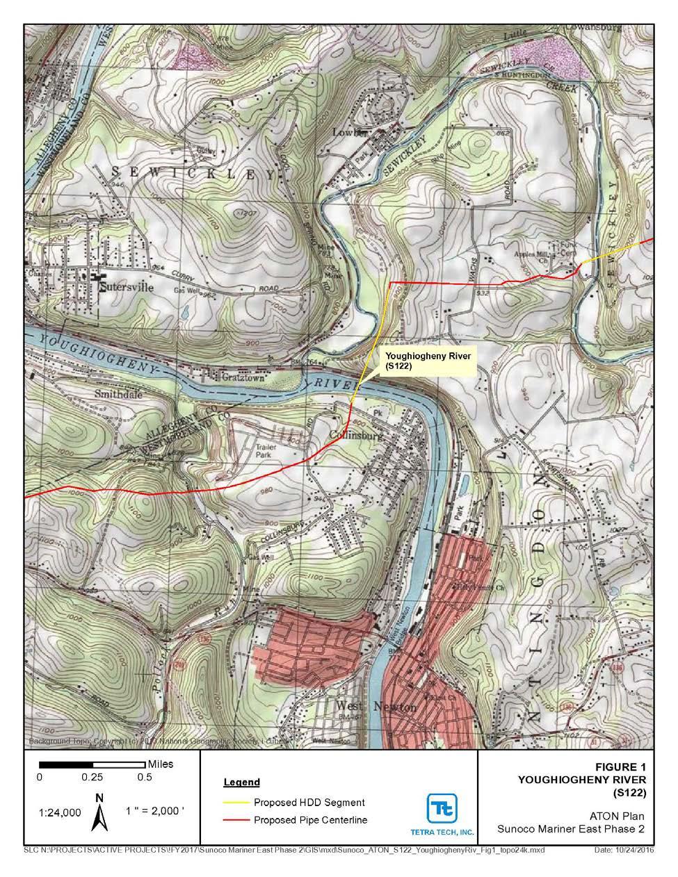
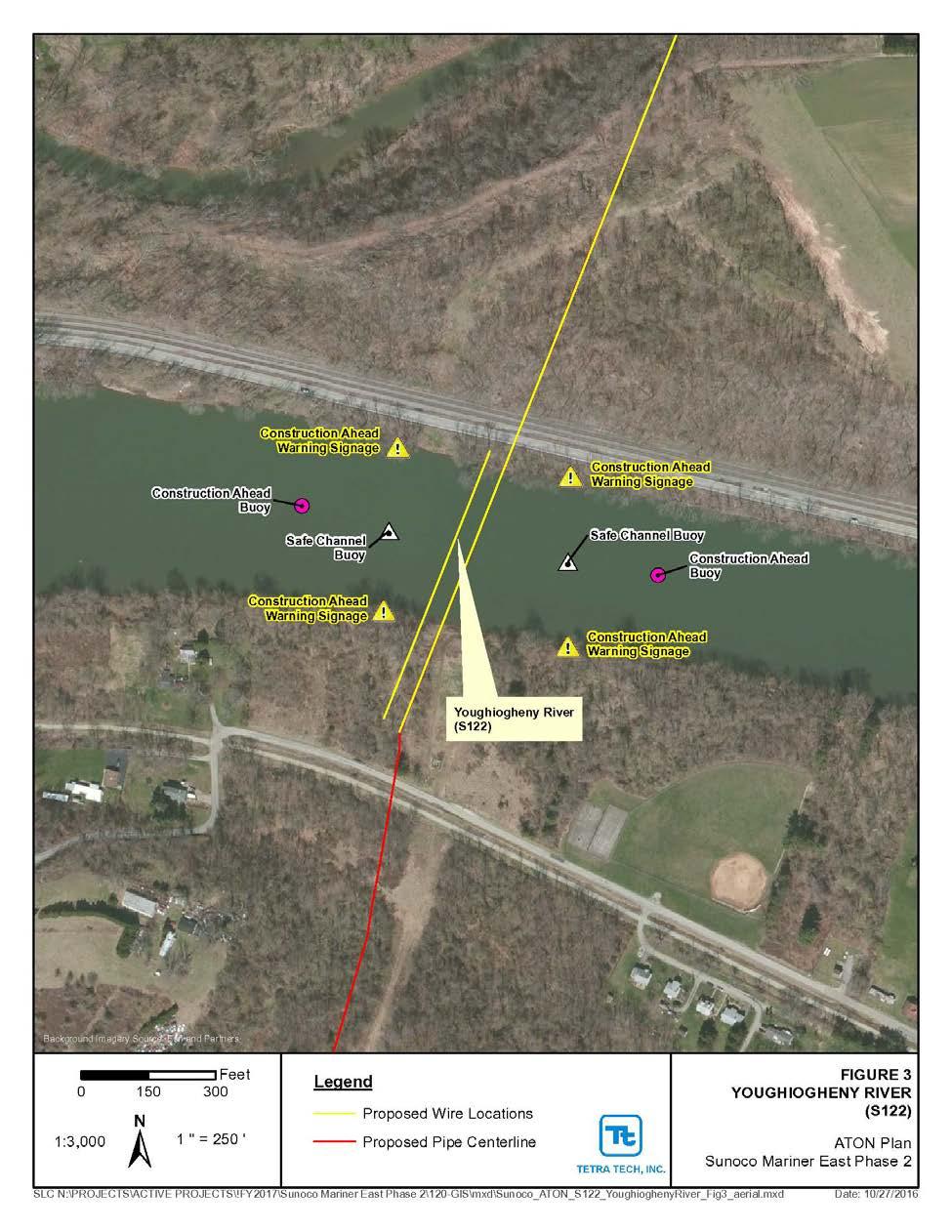
3 Sunoco Pipeline, L.P. HDD Wire Guided Waterway Crossing ATON Plan Mariner East Phase 2 Pipeline Project November 14, INTRODUCTION Sunoco Pipeline, L.P. (SPLP) proposes to construct and operate the Pennsylvania Pipeline Project (Project or PPP) that would expand existing pipeline systems to provide natural gas liquid (NGL) transportation. The Project involves the installation of two parallel pipelines within an approximately mile, 50-foot-wide right-of-way (ROW) from Houston, Washington County, Pennsylvania to SPLP s Marcus Hook facility in Delaware County, Pennsylvania with the purpose of interconnecting with existing SPLP Mariner East pipelines. A 20-inch diameter pipeline will be installed within the ROW from Houston to Marcus Hook (306.8 miles) and a second, 16-inch diameter pipeline, will also be installed in the same ROW. The second line is proposed to be installed from SPLP s Delmont Station, Westmoreland County, Pennsylvania to the Marcus Hook facility, paralleling the initial line for approximately miles. The majority of the new ROW will be co-located adjacent to existing utility corridors, including approximately 230 miles of pipeline that will be co-located in the existing SPLP Mariner East pipeline system. As part of the work, several water crossings are required. Horizontal directional drilling (HDD) is proposed to install the pipeline segments underneath the waterways being crossed. To direct the drilling a 4 6 gauge (direct current) or gauge (alternating current) coated wire is placed at ground surface (beneath the water surface). The wire conducts an electrical current producing a magnetic field that the drill steering tube can reference to direct the position of the drill bit as it drills a boring under the ground surface. The primary purpose of this ATON plan is to insure the safety of recreational boaters who may attempt to travel through or near an area impacted by this construction project. The waterway crossing has been determined to have a potential impact on recreational boating by the Pennsylvania Fish and Boat Commission (PFBC). As required for potentially impacted waterways, this Aid to Navigation (ATON) Plan has been prepared to address the specific equipment to be used in the waterway during the drilling, restrictions placed on boating during the conduct of the work, and navigational aids to be used to communicate hazards and restrictions to boating during the conduct of the work. 2.0 PROJECT SPECIFIC FEATURES The following sections outline specific features of the waterway crossing for the Youghiogheny River (S122). 2.1 WATERWAY CROSSING LOCATION The waterway of concern for this crossing is the Youghiogheny River (stream identification S122) a perennial drainage located in Westmoreland County near the township of West Newton. The latitude and longitude of the crossing, respectively, are , The river width being crossed is approximately 400 feet. Figure 1 presents a site location map of the waterway crossing and surrounding area. Figures 2 and 3 present a close up of a quadrangle map and an aerial photograph of the crossing for the two pipelines. 2.2 SCOPE OF WORK Signs and buoys, as required for the crossing, will be setup as described in Section 2.4 of this plan. A permit application for floating structures referred to as PFBC-277 Application to Install Floating Structure(s) or Private Aids to Navigation will be submitted at least 60 days prior to the installation of such item. The waterway was identified by the PFBC as a HDD Wire Guided Waterway Crossing ATON Plan Page 1
4 shared jurisdictional waterway with the U.S. Coast Guard (USCG) and acquisition of a USCG PATON permit or waiver will be sought. Prior to drilling underneath the waterway the wire guidance system is setup from the HDD staging areas on either side of the waterway. The procedure for installing the wire guidance system will include the following: Wire spools will be delivered to the site at the HDD entry side. Several smaller coils may be used and spliced together in the field to create the loop. The wire will be hand laid on top of the ground and stream bed and spliced together along the HDD path using a small crew of workers. Splices that will end up in the waterway will be made on land prior to installing the cable or in the work boat as the cable is being placed in the waterway. A small boat will be used to lay the cable across the waterway. At this time, no special anchoring is anticipated to be required. If the cable needs to be anchored small weights (5 pounds) will be placed on the cable to immobilize it. The centerline wire is surveyed by a surveyor in a small boat using typical hand held field survey equipment to verify its position. Small floating buoys may be attached to the wire to aid in the surveying of its location. After the HDD is complete, the wires will be removed from the waterway by utilizing the work boat. One HDD drill will be constructed at this location. To accommodate the drill, a centerline wire will be run directly over the intended boring location. A return loop will be laid in the water and offset from the centerline wire by approximately 40 feet. Two wires will be in the water at any one time for the active drill location. Figures 2 and 3 present the wire locations. Passage of recreational boaters will be accommodated during the drilling operation. During initial placement, repositioning of the centerline and loop wires, and removal of the wires, passage in the river may be temporarily and briefly impacted. However, a safe channel for recreational traffic will be provided to direct traffic away from the active work zone. 2.3 ESTIMATED DATES OF CONSTRUCTION The work is anticipated to begin during January The approximate dates of the work at this location will be sent to the PFBC when it is more clearly known. 2.4 DESCRIPTION OF ATON PLAN The Susquehanna River appears to be utilized by both by motorized and non-powered craft and is approximately 400 feet in width along the centerline of the pipeline crossing. Based on this, land based signs in combination with buoys are proposed for the crossing. The signs will include the following: Four construction warning signs, two of each located on each river bank at least 200 feet above and below the work zone, respectively; Two construction warning buoys, one of each located at least 400 feet above and below the work zone, respectively, in the center of the river; and HDD Wire Guided Waterway Crossing ATON Plan Page 2
5 Two safe channel marker buoys located 200 feet above and below the work zone, respectively, to be positioned above the work zone in the safe channel location. Once the cables are set and drilling has commenced the safe channel marker buoys will be removed from the waterway until the cables require repositioning or removal. Figures 2 and 3 present the location of the signage, buoys and work boat for the project. The work boat(s) will primarily be trasversing the river over the cable locations with the exception of the placement of the buoys. The buoys will be standard nine foot inland regulatory buoys. The buoys will be white in color with and include standard symbols identifying the nature of the message in orange, with the message in black lettering. No channel or lighted buoys are proposed. The Appendix presents the proposed signage and buoy details. HDD Wire Guided Waterway Crossing ATON Plan Page 3
6 FIGURES
7

8
9
10 APPENDIX Proposed ATON Signage


11 Drawing is excerpted from PFBC ATON Guidance Document and will be modified to say Warning Construction Area Ahead Use Extreme Caution or similar. Safe Waters (Safe Channel) buoy depiction.

12 Channel informational marking for buoy located above work area during cable installation, repositioning, and removal. Directional arrow will reflect current channel preference. Drawing is excerpted from PFBC ATON Guidance Document. Buoy typical excerpted from PFBC ATON Guidance Document. Buoy markings will be Warning Construction Area Ahead Use Extreme Caution or similar.
Passages Between Acklins Island, Haiti and Caicos Islands NGA Chart A reduced-scale NGA nautical chart for small boaters
 BookletChart Passages Between Acklins Island, Haiti and Caicos Islands NGA Chart 26260 A reduced-scale NGA nautical chart for small boaters When possible, use the full-size NGA chart or Electronic Nautical
Baie de L Acul and Approaches (Haiti) NGA Chart A reduced-scale NGA nautical chart for small boaters
 NGA Chart A reduced-scale NGA nautical chart for small boaters") BookletChart Baie de L Acul and Approaches (Haiti) NGA Chart 26148 A reduced-scale NGA nautical chart for small boaters When possible, use the full-size NGA chart or Electronic Nautical Chart (ENC) for
BookletChart Baie de L Acul and Approaches (Haiti) NGA Chart 26148 A reduced-scale NGA nautical chart for small boaters When possible, use the full-size NGA chart or Electronic Nautical Chart (ENC) for
BookletChart. Port-au-Prince (Haiti) NGA Chart A reduced-scale NGA nautical chart for small boaters
 NGA Chart A reduced-scale NGA nautical chart for small boaters") BookletChart Port-au-Prince (Haiti) NGA Chart 26186 A reduced-scale NGA nautical chart for small boaters When possible, use the full-size NGA chart or Electronic Nautical Chart (ENC) for navigation. VHF
BookletChart Port-au-Prince (Haiti) NGA Chart 26186 A reduced-scale NGA nautical chart for small boaters When possible, use the full-size NGA chart or Electronic Nautical Chart (ENC) for navigation. VHF
BookletChart. Approaches to Cap-Haitien and Bahia de Monti Cristi NGA Chart A reduced-scale NGA nautical chart for small boaters
 BookletChart Approaches to Cap-Haitien and Bahia de Monti Cristi NGA Chart 26142 A reduced-scale NGA nautical chart for small boaters When possible, use the full-size NGA chart or Electronic Nautical Chart
BookletChart. Cap-Haitien NGA Chart A reduced-scale NGA nautical chart for small boaters
 BookletChart Cap-Haitien NGA Chart 26146 A reduced-scale NGA nautical chart for small boaters When possible, use the full-size NGA chart or Electronic Nautical Chart (ENC) for navigation. VHF Marine Radio
BookletChart. Sacramento River Andrus Island to Sacramento NOAA Chart A reduced-scale NOAA nautical chart for small boaters
 BookletChart Sacramento River Andrus Island to Sacramento NOAA Chart 18662 A reduced-scale NOAA nautical chart for small boaters When possible, use the full-size NOAA chart for navigation. Included Area
CHECKLIST PRELIMINARY SUBDIVISION AND PRELIMINARY SITE PLAN
 N/A Waiver (1) Four (4) copies of application form. (2) Fifteen (15) copies of plan (3) Subdivision/site plan application fee & professional review escrow deposit (4) Variance application fee & professional
Appendix B. Airport Master Plan Update William R. Fairchild International Airport Port Angeles, Washington AIRPORT LAYOUT PLAN CHECKLIST
 APPENDICES Appendix B AIRPORT LAYOUT PLAN CHECKLIST 3 Airport Master Plan Update William R. Fairchild International Airport Port Angeles, Washington September 2011 AC 150/5070-6B (incl. Chg. 1, 5/1/07)
Last Name: First Name: M.I:
 ARCHITECTURE DESIGN REVIEW BOARD APPLICATION OFFICE USE ONLY APPLICATION # Permit # Fee Collected $ 1. Filing Status Initial Submission Amendment Withdrawal 2. Cost of Construction (Industry Standards)
State of New Jersey Chris Christie, Governor. Dept. of Environmental Protection Bob Martin, Commissioner
 Cape May Beach 2016/2017 Renourishment Cape May Inlet to Lower Township & Lower Cape May Meadows Cape May Point Cape May County, New Jersey New Jersey Department of Environmental Protection Engineering
Work Type Definition and Submittal Requirements Work Type: Subsurface Utility Engineering (SUE)
") MUST be qualified under Minnesota Department of Transportation Prequalification Program - Work Type 15.1 Subsurface Utility Engineering The first section, Work Type Definition, provides a detailed explanation
MUST be qualified under Minnesota Department of Transportation Prequalification Program - Work Type 15.1 Subsurface Utility Engineering The first section, Work Type Definition, provides a detailed explanation
CITY OF LA MARQUE CHAPTER GRAPHIC REQUIREMENTS CONSTRUCTION PLAN AND MISCELLANEOUS REQUIREMENTS
 CITY OF LA MARQUE CHAPTER 2 -------------------------------------------- GRAPHIC REQUIREMENTS CONSTRUCTION PLAN AND MISCELLANEOUS REQUIREMENTS CHAPTER 2 ------------------------------------------------
A. ARTICLE 4 SKETCH PLAN REQUIREMENTS, MAJOR SUBDIVISION AND/OR LAND DEVELOPMENT
 400. 402.A. ARTICLE 4 SKETCH PLAN REQUIREMENTS, MAJOR SUBDIVISION AND/OR LAND DEVELOPMENT SECTION 400 PURPOSE The purpose of the Sketch Plan is to provide an opportunity for the applicant to consult early
Site Plan Review Application. Interest in the Property (e.g. fee simple, land option, etc.)
") 1. Identification CITY OF FENTON 301 South Leroy Street Fenton, Michigan 48430-2196 (810) 629-2261 FAX (810) 629-2004 Site Plan Review Application Project Name Applicant Name Address City/State/Zip Phone
1. Identification CITY OF FENTON 301 South Leroy Street Fenton, Michigan 48430-2196 (810) 629-2261 FAX (810) 629-2004 Site Plan Review Application Project Name Applicant Name Address City/State/Zip Phone
OAK RUN BUILDING PERMIT
 OAK RUN BUILDING PERMIT (DOCK APPLICATION) ALL PERMIT APPLICATIONS MUST BE SUBMITTED AT THE POA OFFICE A MINIMUM OF 48 HOURS BEFORE THE SCHEDULED MEETING. ALL INFORMATION MUST BE SUPPLIED AND HAVE PROPER
BookletChart. Sacramento River Sacramento to Fourmile Bend NOAA Chart A reduced-scale NOAA nautical chart for small boaters
 BookletChart Sacramento River Sacramento to Fourmile Bend NOAA Chart 18664 A reduced-scale NOAA nautical chart for small boaters When possible, use the full-size NOAA chart for navigation. Included Area
Legal Description & Site Plan Requirements and Layouts
 Legal Description & Site Plan Requirements and Layouts Plot Plan * A plot plan shows the location of a house from an aerial view. * The site plan, also known as a plot or lot plan includes: 1. Site plan
HAMILTON TOWNSHIP Department of Planning and Zoning Application for a Commercial / Industrial Site Plan Review
 HAMILTON TOWNSHIP Department of Planning and Zoning Application for a Commercial / Industrial Site Plan Review Date: Application is hereby made for a Site Plan Review for a commercial or industrial use.
AAPSilver System Performance Validation
 Report No. CG-D-04-13 AAPSilver System Performance Validation Distribution Statement A: Approved for public release; distribution is unlimited. 1 N O T I C E This document is disseminated under the sponsorship
CONCEPT REVIEW GUIDELINES
 Department of Planning & Community Development @ Jefferson Station 1526 E. Forrest Avenue Suite 100 East Point, GA 30344 404.270.7212 (Phone) 404.765.2784 (Fax) www.eastpointcity.org CONCEPT REVIEW GUIDELINES
DOCUMENT MINIMUM CONSTRUCTION DRAWING REQUIREMENTS FOR PRELIMINARY REVIEW/APPROVAL 1.2. GALVESTON COUNTY CONSOLIDATED DRAINAGE DISTRICT (GCCDD)
") DOCUMENT 01105 FOR PRELIMINARY REVIEW/APPROVAL PART I: SUBMITTAL 1.1 CITY OF FRIENDSWOOD (COF) A. Submit four (4) copies of drawings. B. Submit by 5:00 PM a minimum of fourteen calendar days (14 cd) prior
DOCUMENT 01105 FOR PRELIMINARY REVIEW/APPROVAL PART I: SUBMITTAL 1.1 CITY OF FRIENDSWOOD (COF) A. Submit four (4) copies of drawings. B. Submit by 5:00 PM a minimum of fourteen calendar days (14 cd) prior
Site Plan/Building Permit Review
 Part 6 Site Plan/Building Permit Review 1.6.01 When Site Plan Review Applies 1.6.02 Optional Pre- Application Site Plan/Building Permit Review (hereafter referred to as Site Plan Review) shall be required
SUBMITTAL REQUIREMENTS RCV D REJECT PENDING
 1 of 5 SUBMITTAL REQUIREMENTS RCV D REJECT PENDING 1. General Information. 1.1 Applicant s name, address and contact numbers. 1.2 Project name, type, address and legal description of the property. 1.3
DEVELOPMENT PLAN CHECKLIST
 Project Identification Information: DEVELOPMENT PLAN CHECKLIST 1.0 GENERAL 1.1 Additional information as required by specific Land Use 1.2 All sheets to include sheet number ( of ) 1.3 Seal and signature
Example Plans: Business Signs (Not For Construction)
") Plans: Business s Site Plan 220 10 utility easement 120 40 50 Proposed Awning Proposed Freestanding 40 79 20 Street Name Proposed Wall C L N 123 Historic Way Indianapolis, IN 46000 Basic Elements of a
Plans: Business s Site Plan 220 10 utility easement 120 40 50 Proposed Awning Proposed Freestanding 40 79 20 Street Name Proposed Wall C L N 123 Historic Way Indianapolis, IN 46000 Basic Elements of a
TRAFFIC SIGNAL ELECTRICIAN, 3819
 01-31-92 TRAFFIC SIGNAL ELECTRICIAN, 3819 Summary of Duties: A Traffic Signal Electrician performs skilled technical work and acts as a lead for and works with a signal construction crew constructing,
PRELIMINARY PLAT CHECK LIST
 Name of Proposed Subdivision: The following items must be included with the initial submittal of a Preliminary Plat: Application, filled out completely Project Narrative Pre-application Conference Report
Washington County Road Engineering Plan Submittal/Review Checklist
 Washington County Road Engineering Plan Submittal/Review Checklist Washington County Land Use Case File Number: Parcel(s): Developer/Owner Name(s): Developer/Owner E-mail(s): The following elements should
Wellhead Standards. Walter T. Haven, P.G. Energy Program Supervisor
 Wellhead Standards Walter T. Haven, P.G. Energy Program Supervisor Definitions "Wellhead" means the upper terminal of the well including adapters, ports, valves, seals, and other attachments (15A NCAC
B.2 MAJOR SUBDIVISION PRELIMINARY PLAN CHECKLIST
 B.2 MAJOR SUBDIVISION PRELIMINARY PLAN CHECKLIST YES* GENERAL SUBMISSION ITEMS Does the submission include: 1. Thirteen (13) copies of completed Application Form? 2. Thirteen (13) copies of the Preliminary
How Automatic Identification System (AIS) Is Being Used to Improve Navigation Safety Lock Operations Management Application Michael Winkler
 Is Being Used to Improve Navigation Safety Lock Operations Management Application Michael Winkler") How Automatic Identification System (AIS) Is Being Used to Improve Navigation Safety Lock Operations Management Application Michael Winkler June 2016 LOMA system overview USCG AIS data capabilities: AIS
How Automatic Identification System (AIS) Is Being Used to Improve Navigation Safety Lock Operations Management Application Michael Winkler June 2016 LOMA system overview USCG AIS data capabilities: AIS
Plan Preparation Checklist
 Appendix D Plan Preparation Checklist It is the responsibility of the Designer to complete and submit this checklist along with all required drawings for OUC (EFP) Review. All drawings submitted for OUC
HDD Training. HDD Construction Process. Mark Miller, PE Jon Robison, PE
 HDD Training HDD Construction Process Mark Miller, PE Jon Robison, PE What is HDD Horizontal Directional Drilling (HDD) is meant to be a convenient method of installing utilities beneath sensitive areas
1: Introduction : Caution : Tips for Reading this Manual : Preface : System Highlights : Receiver
 1: Introduction....1 1 2: Caution.... 2 2 3: Tips for Reading this Manual....3 3 4: Preface....4 4 5: System Highlights....6 6 6: Receiver..7 7 6.1: Specifications......7 7 6.2: Receiver Operation... 7
This circular summarizes the various important aspects of the LRIT system with a view to enabling companies to ensure compliance in a timely manner.
 Luxembourg, 29/10/2008 CIRCULAR CAM 02/2008 N/Réf. : AH/63353 Subject : Long-Range Identification and Tracking of Ships (LRIT) To : All ship owners, ship operators and designated persons of Luxembourg
Standard Operating Procedures for: VHF Marine Radio
 Serenity Houseboat I. Overview Standard Operating Procedures for: VHF Marine Radio VHF, or Very High Frequency, marine radio is the standard method of communication between vessels. Marine radio equipment
Hartwell Lake Application for Dry Dredging
 Hartwell Lake Application for Dry Dredging Applicant: Mailing Address: E-Mail Address: Day Time Phone Number/s: Dredging Site Address: Subdivision: Lot #: Shoreline Use Permit #: Next Upstream Permit #,
COASTAL MANAGEMENT ELEMENT
 COASTAL MANAGEMENT ELEMENT of the PINELLAS COUNTY COMPREHENSIVE PLAN Prepared By: The Pinellas County Planning Department as staff to the LOCAL PLANNING AGENCY for THE BOARD OF COUNTY COMMISSIONERS OF
Drawbridge Operation Regulation; Oakland Inner Harbor, ACTION: Notice of deviation from drawbridge regulation.
 This document is scheduled to be published in the Federal Register on 03/06/2015 and available online at http://federalregister.gov/a/2015-05231, and on FDsys.gov 9110-04-P DEPARTMENT OF HOMELAND SECURITY
Research Activities Plan. Appendix K Magnetic Fields from Submarine Cables
 VOWTAP Research Activities Plan Appendix K Magnetic Fields from Submarine Cables December 2013 Electrical Engineering and Computer Science Practice Virginia Offshore Wind Technology Advancement Project
MOTE NUUUNE LABORATORY MANATEE RESEARCH ACTIVITIES.
 MOTE NUUUNE LABORATORY MANATEE RESEARCH ACTIVITIES. First Progress Report: August 25, 2008 M MARINE LABORATORY Includes three reports: Photo-Identification Studies on Manatees in Southwestern Florida By:
BookletChart. Intracoastal Waterway Grassy Key to Bahia Honda Key NOAA Chart A reduced-scale NOAA nautical chart for small boaters
 BookletChart Intracoastal Waterway Grassy Key to Bahia Honda Key NOAA Chart 11453 A reduced-scale NOAA nautical chart for small boaters When possible, use the full-size NOAA chart for navigation. Published
TRENCHLESS CONSTRUCTION METHODOLOGIES
 TRENCHLESS CONSTRUCTION METHODOLOGIES Paragraph 2 of the Administrative Order issued by the Pennsylvania Department of Environmental Protection on January 3, 2018, to Sunoco Pipeline, L.P., ( Sunoco )
SECTION TRACER WIRE FOR NONMETALLIC PIPE
 PART 1 GENERAL 1.1 DESCRIPTION A. The CONTRACTOR shall furnish and install a conductive tracer wire with all buried plastic water mains, services and appurtenances in accordance with the Water Utilities
Tri-Met Utility License Rates (2014)
") Tri-Met Rates (2014) Standard license fees: Type Rate Description License Application $2,000 License application fee applies when Licensee in TriMet ROW. Restricted Site Access $300 Access that requires
Tri-Met Rates (2014) Standard license fees: Type Rate Description License Application $2,000 License application fee applies when Licensee in TriMet ROW. Restricted Site Access $300 Access that requires
CHAPTER 11 SURVEY CADD
 CHAPTER 11 SURVEY CADD Chapter Contents Sec. 11.01 Sec. 11.02 Sec. 11.03 Sec. 11.04 Sec. 11.05 Sec. 11.06 Sec. 11.07 Sec. 11.08 Sec. 11.09 Sec. 11.10 General Description of Survey File Contents of Survey
For crossing under a railroad, contact the specific railroad company's engineering department.
 PAGE 330524-1 SECTION 330524 SPECIFIER: This section is for the underground installation of piping by directional drilling. When specifying this method of piping installation, care must be taken to ensure
Proposed Anchorage Grounds, Hudson River; Yonkers, NY to Kingston, NY Docket Number USCG
 August 8, 2016 U.S. Coast Guard First District C/O Mr. Craig Lapiejko Waterways Management Branch Submitted Via Federal erulemaking Portal Subject: Proposed Anchorage Grounds, Hudson River; Yonkers, NY
BookletChart. Chesapeake Bay Pocomoke and Tangier Sounds NOAA Chart A reduced-scale NOAA nautical chart for small boaters
 BookletChart Chesapeake Bay Pocomoke and Tangier Sounds NOAA Chart 12228 A reduced-scale NOAA nautical chart for small boaters When possible, use the full-size NOAA chart for navigation. Published by the
David J. Gellner, AICP, Principal Planner
 Staff Report PLANNING DIVISION COMMUNITY & ECONOMIC DEVELOPMENT To: From: Salt Lake City Planning Commission David J. Gellner, AICP, Principal Planner - 801-535-6107 - david.gellner@slcgov.com Date: October
October 21, 2010 Gregory Scott California State Lands Commission
 October 21, 2010 Gregory Scott California State Lands Commission 1 California State Lands Commission Background Established in 1938 by passage of the State Lands Act Authority: Div. 6 or the California
Navigation Systems Division
 Prevention Department Navigation Systems Division SCF - Small Craft Facility Updating NOAA - AUXILIARY PARTNERSHIP SCF Training Program Presented by members of the US Coast Guard Auxiliary Navigation Systems
Testimony by. Before the. Boston, Mass. July 24, 2002
 360networks inc. Alcatel Submarine Networks AT&T Corp. Gemini Submarine Cable System, Inc. Global Crossing Ltd. Global Marine Systems Limited Global Photon Systems, Inc. GlobeNet Communications Group Ltd.
50.24 Type, Size and Location Plans for Culverts, Bridges and Culvert Bridges
 50.24 Culverts, Bridges and Culvert Bridges Type, Size and Location (T, S & L) Plans shall be required for all Bridges, Culvert Bridges and Culverts of eight-foot (8') clear span or greater as follows:
STATE UNIVERSITY CONSTRUCTION FUND
 DIRECTIVE 1C-12 Issue date: August 2012 1. General SURVEY, MAPPING AND UTILITY LOCATING This Directive has been developed as a general guide for the survey and mapping effort required for Fund projects.
BRASELTON WATER AND WASTEWATER DEPARTMENT CONSTRUCTION PLAN REVIEW CHECKLIST May 2006
 Project Name: BRASELTON WATER AND WASTEWATER DEPARTMENT CONSTRUCTION PLAN REVIEW CHECKLIST May 2006 Phase: Unit: # Lots: Development Type (residential, commercial, industrial, etc.) Braselton Project No.
*********************************************************************************************************
 10400 IDENTIFYING DEVICES ********************************************************************************************************* SPECIFIER: CSI MasterFormat 2004 number: 10 14 00 *********************************************************************************************************
SECTION SITE SURVEYS
 SECTION 02 21 13 SITE SURVEYS SPEC WRITER NOTE: 1. Delete text between // // not applicable to project. Edit remaining text to suit project. 2. Use this section to specify survey required before design
National Maritime Center
 National Maritime Center Providing Credentials to Mariners (Sample Examination) Page 1 of 6 Choose the best answer to the following Multiple Choice Questions. 1. The following questions are based on Chart
Scioto Valley Chapter of THE NINETY-NINES, Inc.
 Scioto Valley Chapter of THE NINETY-NINES, Inc. Columbus, Ohio COMPASS ROSE: 12-point / 70-ft. Diameter ACKNOWLEDGEMENTS The Scioto Valley Chapter of the Ninety-Nines uses the basic design of the compass
SPECIFICATIONS FOR THE INSTALLATION OF CONDUIT SYSTEMS IN RESIDENTIAL SUBDIVISIONS. Notification of Completed Conduit Sections
 SPECIFICATIONS FOR THE INSTALLATION OF CONDUIT SYSTEMS IN RESIDENTIAL SUBDIVISIONS Section 1 Definitions 2 Scope of Work 3 Extent of Work 4 Inspection and Performance of Work 5 Trenching 6 Duct Installation
Notice to Mariner No. 213
 To : Attn: From: All Agents, Bunkering Companies, Coast Guard, National Transport Authority, Hydrographic Office Operations Manager Capt. Tamer Masoud Harbour Master Facsimile No.: City: Fujairah Country:
United States Coast Guard Office of Navigation Systems
 United States Coast Guard Office of Navigation Systems Future of Navigation Initiatives & Operations R. David Lewald Program Analyst Navigation Systems Office of Navigation Systems U.S. Coast Guard Washington,
UTILITY SERVICE/REPAIR PERMIT
 Form M-21 Revised: September TRANSPORTATION COMMISSION OF WYOMING and its UTILITY SERVICE/REPAIR PERMIT 1. Parties. The parties to this License are, hereinafter referred to as Permittee, whose address
Empire Wind Offshore Wind Farm OCS-A 0512
 Empire Wind Offshore Wind Farm OCS-A 0512 Fisheries Liaison & Outline Classification: Open Status: Draft Expiry date: 28-07-04 Page 1 of 13 Title: Empire Wind Fisheries Liaison & Outline Document no. :
ULTRA SPACE SAVER SQUARED Installation Instructions
 Installation Instructions The Ultra Space Saver Squared has several steps for installation. Note that the single and double sided setups and parts are different. Make sure you follow the instructions according
APPLICATION FOR SITE PREPARATION PERMIT
 Engineering Division 550 Landa Street New Braunfels, Texas 78130 (830) 221-4020 1. Subdivision/Plat Name: Location Description/ Nearest Intersection: Acreage: APPLICATION FOR SITE PREPARATION PERMIT No.
Humboldt Bay Piling Removal
 REQUEST FOR PROPOSALS Humboldt Bay Piling Removal Invitation for Proposals The Humboldt Bay Harbor, Recreation & Conservation District (District) is requesting proposals from qualified individuals/firms
Oakland County Michigan Register of Deeds Plat Engineering, GIS, & Remonumentation Dept. Ph: (248) Fax (248)
 Fax (248)") Oakland County Michigan Register of Deeds Plat Engineering, GIS, & Remonumentation Dept. Ph: (248)-858-1447 Fax (248)-858-7466 Requirements Needed for Final Condominium Approval General Requirements. 1
Oakland County Michigan Register of Deeds Plat Engineering, GIS, & Remonumentation Dept. Ph: (248)-858-1447 Fax (248)-858-7466 Requirements Needed for Final Condominium Approval General Requirements. 1
Essentials of Navigation
 Essentials of Navigation Latitudes & Longitudes, GPS, and more For Race Officers and Mark Boat Operators by Ed Bottrell eztrap Developer Glen Haven, Nova Scotia CANADA v13 email: info@bottrell.ca Website:
PLANNING DIVISION COMMUNITY & NEIGHBORHOODS DEPARTMENT
 Staff Report PLANNING DIVISION COMMUNITY & NEIGHBORHOODS DEPARTMENT To: Salt Lake City Administrative Hearing Officer From: Casey Stewart; 801-535-6260 Date: Re: September 22, 2017 (for September 28 Administrative
ULTRA SPACE SAVER Installation Instructions
 Installation Instructions The Ultra Space Saver has several steps for installation. Note that the single and double sided setups and parts are different. Make sure you follow the instructions according
TRANSACTION RECORD TR
 COMMON GROUND ALLIANCE BEST PRACTICES COMMITTEE Proposal Form Revision to Best Practice Name: Ralph Graeser Date: 03/09/2015 Affiliation: PA PUC/NAPSR/GPTC Member. Phone: 717-554-3666 E-Mail: rgraeser@pa.gov
Lab #8: Topographic Map Lab
 NAME: LAB TIME: TA NAME: Lab #8: Topographic Map Lab Topography is the shape of the land. Topographic maps are used to aid in the visualization of the shape of the land. Topographic maps include the accurate
there is a description of the vessel, you will substitute the prop description of your boat. VHF Booklet
 VHF Booklet Imagine what may happen if a distress situation were to take place and you or a guest on your boat needed to place some form of priority call. In the excitement of the moment, it is easy to
CITY OF SCHENECTADY NEW YORK CITY PLANNING COMMISSION
 CITY OF SCHENECTADY NEW YORK CITY PLANNING COMMISSION Christine S. Primiano, Principal Planner Room 14, City Hall, Jay Street SCHENECTADY, NY 12305-1938 518.382.5147 cprimiano@schenectadyny.gov www.cityofschenectady.com
MM540 Installation Instructions IMPORTANT SAFETY INSTRUCTIONS - SAVE THESE INSTRUCTIONS
 MM50 Installation Instructions IMPORTANT SAFETY INSTRUCTIONS - SAVE THESE INSTRUCTIONS Please read this entire manual before you begin. Do not unpack any contents until you verify all requirements on PAGE.
PUBLICATION 213. Think Safety First
 PUBLICATION 213 (67 PA CODE, CHAPTER 212) Think Safety First Pub 213 (02-08) Appendix Appendix A - Temporary/Portable
ENGINEERING REPORT PHASES I & II MITIGATOR PERFORMANCE TESTS
 ENGINEERING REPORT PHASES I & II MITIGATOR PERFORMANCE TESTS INDUCED AC MITIGATION PERFORMANCE ON A STEEL GAS TRANSMISSION PIPELINE REPORT OF JANUARY 29, 2014 Copyright MATCOR, Inc. 2014 MITIGATOR TM VS.
I. REQUEST: The undersigned petition the Village of Matteson, Illinois to approve the application(s) submitted.
 submitted.") SITE PLAN BUILDING ELEVATION LANDSCAPE PLAN SIGNAGE PLAN APPLICATION FOR THE VILLAGE OF MATTESON I. REQUEST: The undersigned petition the Village of Matteson, Illinois to approve the application(s) submitted.
SITE PLAN BUILDING ELEVATION LANDSCAPE PLAN SIGNAGE PLAN APPLICATION FOR THE VILLAGE OF MATTESON I. REQUEST: The undersigned petition the Village of Matteson, Illinois to approve the application(s) submitted.
Town of Skowhegan Application For Development Review
 Town of Skowhegan Application For Development Review Return to: Skowhegan Planning Office 225 Water St., Skowhegan, ME 04976 (207) 474-6904 skowcodesec@skowhegan.org To be filled in by Staff: Project Name:
Proposed Action Hutch Mountain Communications Site Coconino National Forest June 2016
 Proposed Action Hutch Mountain Communications Site Coconino National Forest June 2016 PURPOSE AND NEED The proposed Hutch Mountain Communications Site project is part of a broader wireless industry strategy
Grease Interceptor Design Checklist
 CHECKLIST C2 Revised 5/2/2016 Grease Interceptor Design Checklist Public Works DISCLAIMER - This checklist is provided to Consulting Engineers for the express purpose of assisting them in compiling private
CHAPTER 1: TITLE SHEET and GENERAL LAYOUT
 CHAPTER 1: TITLE SHEET and GENERAL LAYOUT AREA OF ENVIRONMENTAL SENSITIVITY It is important to show the areas of environmental sensitivity in the plan to make sure these areas are not impacted. These locations
SAFETY EQUIPMENT AND PREPARATION. S/V Odette USA 5619
 SAFETY EQUIPMENT AND PREPARATION S/V Odette USA 5619 Odette5619@gmail.com COMMUNICATION PREPARATION Dedicate dock time for crew to familiarize themselves with all communication equipment: VHF: Walk through
Introductory remarks
 Introductory remarks This document is a draft of a permit for Gaz System to construct a natural gas pipeline on the Danish continental shelf in the Baltic Sea. It should be emphasised that it has not yet
STATE OF NEW JERSEY BOARD OF PUBLIC UTILITIES
 STATE OF NEW JERSEY BOARD OF PUBLIC UTILITIES : IN THE MATTER OF THE PETITION OF : PUBLIC SERVICE ELECTRIC AND GAS : COMPANY FOR A DETERMINATION : PURSUANT TO THE PROVISIONS OF : N.J.S.A. 0:D-1 : BPU DOCKET
Ultra Space Saver American Bicycle Security Company
 The Ultra Space Saver is userfriendly and allows easy access to bikes. It provides convenient space for u-lock security on nearly any bike, including bikes with fenders and fork shocks. The double-sided
CHAPTER 3 INFORMATION REQUIRED FOR PUBLIC IMPROVEMENT CONSTRUCTION PLANS TABLE OF CONTENTS
 CHAPTER 3 INFORMATION REQUIRED FOR PUBLIC IMPROVEMENT CONSTRUCTION PLANS TABLE OF CONTENTS Section Title Page 3.1 General... 3-1 3.1.1 Plan Set...3-1 A. Loveland (City Limits Only)...3-1 3.1.2 Final Mylars...3-1
FOR MORE INFORMATION ON GMDSS CONTACT:
 FOR MORE INFORMATION ON GMDSS CONTACT: Commanding Officer USCG Navigation Center, MS 7310, 7323 Telegraph Road, Alexandria, VA 20598-7310 Tel:1-703-313-5900 www.navcen.uscg.gov Commandant (CG-652) Spectrum
Introduction to Aerial Photographs and Topographic maps (Chapter 3)
") GEOLOGY 306 Laboratory Instructor: TERRY J. BOROUGHS NAME: Introduction to Aerial Photographs and Topographic maps (Chapter 3) For this assignment you will require: a calculator and metric ruler. Objectives:
GEOLOGY 306 Laboratory Instructor: TERRY J. BOROUGHS NAME: Introduction to Aerial Photographs and Topographic maps (Chapter 3) For this assignment you will require: a calculator and metric ruler. Objectives:
Appendix Traffic Engineering Checklist - How to Complete. (Refer to Template Section for Word Format Document)
") Appendix 400.1 Traffic Engineering Checklist - How to Complete (Refer to Template Section for Word Format Document) Traffic Engineering Checksheet How to Complete the Form June 2003 Version 3 Maintained
Appendix 400.1 Traffic Engineering Checklist - How to Complete (Refer to Template Section for Word Format Document) Traffic Engineering Checksheet How to Complete the Form June 2003 Version 3 Maintained
BookletChart. St. Joseph and Benton Harbor NOAA Chart A reduced-scale NOAA nautical chart for small boaters
 BookletChart St. Joseph and Benton Harbor NOAA Chart 14930 A reduced-scale NOAA nautical chart for small boaters When possible, use the full-size NOAA chart for navigation. Included Area Published by the
Applying for a Site Development Review (Sign CVCBD only)
") Guide Applying for a Site Development Review (Sign CVCBD only) What is it? Site Development Review ensures that new buildings or land uses are compatible with their sites and with the surrounding environment,
Guide Applying for a Site Development Review (Sign CVCBD only) What is it? Site Development Review ensures that new buildings or land uses are compatible with their sites and with the surrounding environment,
DIVISION PAVEMENT MARKINGS AND MARKERS
 DIVISION 61 66 PAVEMENT MARKINGS AND MARKERS 66.01 SCOPE: The purpose of these specifications is to describe the minimum requirements of the City of Chesapeake for pavement markings and shall be in addition
Porter County Plan Commission
 Plan Type: Development Plan Administrative DRC PC Primary Plan Administrative DRC PC Secondary Plat/Replat Administrative DRC PC PUD Conceptual Detailed Final Project Information Project Name: Developer
MARINE PRIVATE MOORAGE APPLICATION REQUIREMENTS; EXAMPLE PLANS
 MARINE PRIVATE MOORAGE APPLICATION REQUIREMENTS; EXAMPLE PLANS 1) SMALL SCALE GENERAL SITE PLAN A : The purpose of this map is to indicate the location of the application in relation to surveyed parcels
ASSEMBLY INSTRUCTIONS FOR SOFTOP SHADE COVER
 ASSEMBLY INSTRUCTIONS FOR SOFTOP SHADE COVER Our unique assembly process quickly transforms individual pieces into a finished structure that will give you a lifetime of service. Great care has been taken
CITY OF EL MIRAGE DEVELOPMENT APPLICATION PROCESS
 DEVELOPMENT APPLICATION PROCESS Development Applications are reviewed by the El Mirage Technical Advisory Committee (TAC) to ensure Building, Engineering and Zoning compliance before scheduling public
MM340 Installation Instructions IMPORTANT SAFETY INSTRUCTIONS - SAVE THESE INSTRUCTIONS
 MM30 Installation Instructions IMPORTANT SAFETY INSTRUCTIONS - SAVE THESE INSTRUCTIONS Please read this entire manual before you begin. Do not unpack any contents until you verify all requirements on PAGE.