5/14/2018. About Your Hosts. Mapping Accessibility Through Google Street View. Captioning
|
|
|
- Nathan Simmons
- 5 years ago
- Views:
Transcription
1 arrow points to the "cc" icon in the audio and video panel Transc en logo and NIDILR R logo 5/14/2018 Mapping Accessibility Through Google Street View will begin at 12:30 pm ET Audio and Visual are provided through the on-line webinar system. This session is closed captioned. Individuals may also listen via telephone by dialing Access Code: This is not a toll-free number. Captioning Real-time captioning is provided; open the window by selecting the CC icon in the AUDIO & VIDEO panel You can move and re-size the captioning window. Within the window you change the font size, and save the transcript About Your Hosts TransCen, Inc. Mission Statement: Improving lives of people with disabilities through meaningful work and community inclusion Mid-Atlantic ADA Center, a project of TransCen, Inc. Funded by National Institute on Disability, Independent Living, and Rehabilitation Research (NIDILRR), Administration for Community Living, U.S. Department of Health and Human Services 1


2 arrow points to microphone icon on audio and video panel Resizing dropdown box 5/14/2018 Listening to the Webinar Online: Please make sure your computer speakers are turned on or your headphones are plugged in Control the audio broadcast via the AUDIO & VIDEO panel If you have sound quality problems, please go through the AUDIO WIZARD by selecting the microphone icon within the AUDIO & VIDEO panel Listening to the Webinar (cont.) To connect by telephone: Pass Code: This is not a toll-free number Customizing Your View Resize the whiteboard where the presentation slides are shown to make it smaller or larger by choosing from the drop down menu located above and to the left of the whiteboard; the default is fit page 2
3 Customize Your View continued Resize/Reposition the CHAT, PARTICIPANT, and AUDIO & VIDEO panels by detaching and using your mouse to reposition or stretch/shrink Each panel may be detached using the icon in the upper right corner of each panel Technical Assistance If you experience technical difficulties Use the CHAT panel to let us know Call Archive This webinar is being recorded and can be accessed within a few weeks You will receive an with information on accessing the archive 3


4 Mapping Accessibility Through Google Street View will begin at 12:30 pm ET Audio and Visual are provided through the on-line webinar system. This session is closed captioned. Individuals may also listen via telephone by dialing Access Code: This is not a toll-free number. Mapping accessibility via Google Street Associate Professor Computer Science University of Washington 4


5 Project Sidewalk The Team Professors Grad students Jon Froehlich David Jacobs Kotaro Hara Manaswi Saha Michael Jin Sun Soheil Saugstad Behnezhad Undergraduate Students Maria Furman Vicki Le Robert Moore Christine Chan Daniil Zadorozhnyy High School Students Jonah Chazan Anthony Li Niles Rogoff Zach Lawrence And more and more Alex Zhang Improving access to the physical world Our overarching research Question How can we develop scalable solutions that map the accessibility of urban infrastructure? Project Sidewalk [ASSETS 12, CHI 13, HCOMP 13, ASSETS 13 Best Paper, UIST 14, TACCESS 15, SIGACCESS 15, CHI 16, ASSETS 17] 30.6 million U.S. adults have a mobility impairment Source: US Census, 210 5

6 15.2 million use an assistive aid Source: US Census, 210 No Curb Ramps 6


7 Physical Obstacles Incomplete Sidewalks Surface Problems 7


![, 2004 ; Nuernberger, 2008] I usually don t go](/docs-images/82/85243149/images/8-2.jpg "where I don t know [about accessible routes]")
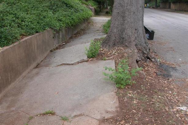
8 Physical Obstacles No Curb Ramp Surface Degradation Accessible infrastructure has a significant impact on the independence and mobility of citizens [Thapar et al., 2004 ; Nuernberger, 2008] I usually don t go where I don t know [about accessible routes] -P3, congenital polyneuropathy 8

9 A key challenge is that there are few mechanisms to determine accessible areas of a city a priori The National Council on Disability noted that there is no comprehensive information on the degree to which sidewalks are accessible in cities. National Council on Disability, 2007 The impact of the Americans with Disabilities Act: Assessing the progress toward achieving the goals of the ADA There are many approaches for data collection but they typically require onsite reporting, which limits scalability 9


10 Accessibility data collection Traditional accessibility audits Walkability Audit Wake County, North Carolina Walkability Audit Wake County, North Carolina Safe Routes to School Walkability Audit Rock Hill, South Carolina Accessibility Data Collection 311 Systems Accessibility data collection Mobile reporting solutions 10


11 Accessibility data collection Mobile reporting solutions The NYC311 app has a specific option for broken sidewalks Accessibility data collection Reporting on accessibility of places g g 11
12 Accessibility data collection Reporting on accessibility of places rg org These are fantastic and important tools but they focus on the accessibility of places rather than the accessibility of how to get to places. Accessibility data collection Reporting on accessibility of places rg org Moreover, they require onsite access of a place to submit a report. We are pursuing a complementary two-fold approach 12


13 Surface Problems 1 To develop scalable methods that mine massive repositories of online map imagery to identify accessibility problems semiautomatically No Curb Ramps Physical Obstacles 13


14 Physical Obstacles 2 To create new accessibility-aware mapping tools that support people with disabilities and provide unprecedented views of urban accessibility Mouse over neighborhoods to view access score 14

15 Personalize score based on mobility level Upping severity of surface problems 15


16 Mapping The Accessibility of the World Two Focus Areas 1 Scalable Data Collection Methods [ASSETS 12, CHI 13, HCOMP 13, ASSETS 13, UIST 14, TACCESS 15, ASSETS 17] 2 New accessibility-aware mapping tools [SIGACCESS 15, CHI 16] Mapping The Accessibility of the World Key Research Questions 1 Scalable Data Collection Methods [ASSETS 12, CHI 13, HCOMP 13, ASSETS 13, UIST 14, TACCESS 15, ASSETS 17] Is online map imagery a good source for accessibility data? Can we create interactive tools that enable crowd workers to find accessibility problems? How can we leverage computational techniques to scale our approach? Mapping The Accessibility of the World Key Research Questions 1 Scalable Data Collection Methods [ASSETS 12, CHI 13, HCOMP 13, ASSETS 13, UIST 14, TACCESS 15, ASSETS 17] Is online map imagery a good source for accessibility data? Can we create interactive tools that enable crowd workers to find accessibility problems? How can we leverage computational techniques to scale our approach? 16


17 Google Streetview Real World Put another way: How well do accessibility problems found in Google Street View correspond with the real world? Is Google Street view a reasonable Dataset for accessibility audits? Physical Audits vs. Google Street View 179 Bus stops Washington DC & Seattle 42 km surveyed 273 intersections Washington DC & Baltimore 34 km surveyed 17


 Avg image age in Intersection")
18 Is Google Street view a reasonable Dataset for accessibility audits? Comparison Results: Spearman rank coefficients Bus Stops Intersections vs. vs. Physical Audit Data GSV Audit Data ρ= 0.88 Physical Audit Data GSV Audit Data ρ= 0.98 All results statistically significant at p < Is Google Street view a reasonable Dataset for accessibility audits? Consistent With Findings in literature See: Odgers et al., 2012; Wilson et al., 2013; Kelly et al., 2013; Bader, et al., 2017 Is Google Street view a reasonable Dataset for accessibility audits? City infrastructure changes slowly Avg image age in Bus Stop Dataset 1.7 yrs (SD=0.7) Avg image age in Intersection Dataset 1.5 yrs (SD=0.7) 18


19 Google Street View is a reasonable proxy for studying the state of street-level accessibility 19


20 Mapping The Accessibility of the World Key Research Questions 1 Scalable Data Collection Methods [ASSETS 12, CHI 13, HCOMP 13, ASSETS 13, UIST 14, TACCESS 15, ASSETS 17] Is online map imagery a good source for accessibility data? Can we create interactive tools that enable crowd workers to find accessibility problems? How can we leverage computational techniques to scale our approach? Mapping The Accessibility of the World Key Research Questions 1 Scalable Data Collection Methods [ASSETS 12, CHI 13, HCOMP 13, ASSETS 13, UIST 14, TACCESS 15, ASSETS 17] Is online map imagery a good source for accessibility data? Can we create interactive tools that enable crowd workers to find accessibility problems? How can we leverage computational techniques to scale our approach? Crowdsourcing Accessibility Audits Initial Crowdsourcing System Labeling Interface Verification Interface 20
21 Crowdsourcing Accessibility Audits Web-based Labeling Interface 4-Step Process 1. Find & label problem Crowdsourcing Accessibility Audits Web-based Labeling Interface 4-Step Process 1. Find & label problem Crowdsourcing Accessibility Audits Web-based Labeling Interface 4-Step Process 1. Find & label problem 2. Categorize problem 21
22 Crowdsourcing Accessibility Audits Web-based Labeling Interface 4-Step Process 1. Find & label problem 2. Categorize problem Crowdsourcing Accessibility Audits Web-based Labeling Interface 4-Step Process 1. Find & label problem 2. Categorize problem 3. Rate problem severity Crowdsourcing Accessibility Audits Web-based Labeling Interface 4-Step Process 1. Find & label problem 2. Categorize problem 3. Rate problem severity 22

23 Crowdsourcing Accessibility Audits Web-based Labeling Interface 4-Step Process 1. Find & label problem 2. Categorize problem 3. Rate problem severity 4. Submit work Crowdsourcing Accessibility Audits Web-based Labeling Interface 4-Step Process 1. Find & label problem 2. Categorize problem 3. Rate problem severity 4. Submit work Receive another image to label & process repeats. Crowdsourcing Accessibility Audits Web-Based Verification Interface 3-Step Process 1. Verify label 23

24 Crowdsourcing Accessibility Audits Web-Based Verification Interface 3-Step Process 1. Verify label Crowdsourcing Accessibility Audits Web-Based Verification Interface 3-Step Process 1. Verify label 2. Verify rating Crowdsourcing Accessibility Audits Web-Based Verification Interface 3-Step Process 1. Verify label 2. Verify rating 3. Provide details 24


25 Crowdsourcing Accessibility Audits Web-Based Verification Interface 3-Step Process 1. Verify label 2. Verify rating 3. Provide details Check for false negatives Crowdsourcing Accessibility Audits Study Method 1. Create image dataset 2. Generate ground truth labels 3. Deploy our tools to crowd 4. Compare performance to ground truth 1 Crowdsourcing Accessibility Study Method Downloaded 229 GSV Images New York Baltimore Baltimore Washington DC Los Angeles 25
26 50 images Sidewalk Ending 66 images Object in Path 67 images Surface Problems 47 images Missing Curb Ramps 50 images No Problems Crowdsourcing Accessibility Audits Study Method 1. Create image dataset 2. Generate ground truth labels 26

27 2 Crowdsourcing Accessibility Study Method Create Ground Truth Labels Object in Path Bob Sue Alice Object in Path No Curb Ramp Bob s Labels Object in Path Object in Path Sue s Labels Object in Path Object in Path No Curb Ramp Alice s Labels Majority Vote } Object in Path Object in Path No Curb Ramp Researcher Ground Truth Crowdsourcing Accessibility Audits Study Method 1. Create image dataset 2. Generate ground truth labels 3. Deploy our tools to crowd 3 Crowdsourcing Accessibility Study Method Deploy Tools to Mechanical Turk 27
28 Crowdsourcing Accessibility Study Results Mturk Study Statistics 185 Labelers 7,517 Labels 35.2s Label An Image 273 Verifiers 19,189 Verifications 10.5s Verify An Image Crowdsourcing Accessibility Study Results Mturk Study Statistics 185 Labelers 7,517 Labels 35.2s Label An Image 273 Verifiers 19,189 Verifications 10.5s Verify An Image Crowdsourcing Accessibility Audits Study Method 1. Create image dataset 2. Generate ground truth labels 3. Deploy our tools to crowd 4. Compare performance to ground truth 28
29 Are crowd workers capable of finding accessibility problems in online map imagery? Crowdsourcing Accessibility Study Results Overall Labeling Accuracy With one labeler per image Sidewalk Ending 85% Crowdsourcing Accessibility Study Results Overall Labeling Accuracy With one labeler per image Sidewalk Ending Missing Curb Ramps Surface Problem Object in Path 85% 79% 77% 73% 29
30 Crowdsourcing Accessibility Study Results Overall Labeling Accuracy With one labeler per image Average Overall Accuracy 78% 81% Sidewalk Ending 85% Missing Curb Ramps Surface Problem Object in Path 79% 77% 73% Multiclass Overall Sidewalk Ending No Curb Ramp Surface Problem Object in Path No Problem Binary Overall Problem No Problem Crowdsourcing Accessibility Study Results Common Labeler Mistakes Over labeling (i.e., tendency towards false positives) Crowdsourcing Accessibility Study Results Common Labeler Mistakes Over labeling (i.e., tendency towards false positives) Random Labels Category errors (e.g., misunderstanding, malevolence) (i.e., ambiguous problem category) 30
31 Average Accuracy (%) Average Accuracy (%) Average Accuracy (%) 5/14/2018 Crowdsourcing Accessibility Study Results Accuracy as a function of Labelers Per Image 100% 90% 80% 70% 60% 50% 1 turker 1 labeler (N=28) 3 turkers 3 labelers (N=9) 5 turkers 5 labelers (N=5) 7 turkers 7 labelers (N=4) 9 turkers 9 labelers (N=3) (majority vote) (majority vote) (majority vote) (majority vote) Error bars: standard error Crowdsourcing Accessibility Study Results Accuracy as a function of Labelers Per Image 100% 90% 80% Multiclas s 78% 84% 87% 87% 88% 70% 60% 50% 1 turker 1 labeler (N=28) 3 turkers 3 labelers (N=9) 5 turkers 5 labelers (N=5) 7 turkers 7 labelers (N=4) 9 turkers 9 labelers (N=3) (majority vote) (majority vote) (majority vote) (majority vote) Error bars: standard error Crowdsourcing Accessibility Study Results Accuracy as a function of Labelers Per Image 100% 90% 80% Multiclas s 81% 78% Binar y 87% 84% 90% 91% 90% 87% 87% 88% 70% 60% 50% 1 turker 1 labeler (N=28) 3 turkers 3 labelers (N=9) 5 turkers 5 labelers (N=5) 7 turkers 7 labelers (N=4) 9 turkers 9 labelers (N=3) (majority vote) (majority vote) (majority vote) (majority vote) Error bars: standard error 31
32 Average Accuracy (%) 5/14/2018 Crowdsourcing Accessibility Study Results Accuracy With Crowd verification 100% 90% 80% 75% 81% 78% 88% 89% 80% 93% Multiclas s 82% 82% Binar y 91% 70% 60% 50% 1 labeler 1 labeler, 3 verifiers Time COST Error bars: standard error; experiments run on subset of data 3 labelers 3 labelers, 3 verifiers 5 labelers With basic quality control measures, minimally trained crowd workers can find accessibility problems with an accuracy of ~93% But this approach relied purely on manual labor. Can we do better? 32


33 Mapping The Accessibility of the World Key Research Questions 1 Scalable Data Collection Methods [ASSETS 12, CHI 13, HCOMP 13, ASSETS 13, UIST 14, TACCESS 15, ASSETS 17] Is online map imagery a good source for accessibility data? Can we create interactive tools that enable crowd workers to find accessibility problems? How can we leverage computational techniques to scale our approach? Tohme 遠目 Remote Eye Tohme 遠目 Remote Eye 1 svcrawl Web Scraper 33

34 Tohme 遠目 Remote Eye 1 svcrawl Web Scraper Google Street View Panoramas 3D Point-cloud Data Top-down Google Maps Imagery 2 Street View images 3D-depth maps GIS Metadata Top-down map images <Latitude & longitude/> GIS metadata <GSV image age/> Street Dataset <Street & city names/> <Intersection topology/> Scraped Area: 11.3 km 2 Tohme 遠目 Remote Eye Scraped Area: 11.3 km 2 Urban Residenti al 1 svcrawl Web Scraper D.C. Baltimore Los Angeles Saskatoon Dataset Statistics 2 Street View images 3D-depth maps Top-down map images GIS metadata Street Dataset 1,086 intersections 2,877 curb ramps 647 missing curb ramps 2.2 yrs (SD=1.3) average GSV image age Tohme 遠目 Remote Eye 1 svcrawl 3 svdetect Web Scraper Automatic Curb Ramp Detection 2 Street View images 3D-depth maps Top-down map images GIS metadata Street Dataset 34
35 Tohme 遠目 Remote Eye 1 svcrawl 3 svdetect Web Scraper Automatic Curb Ramp Detection 2 Street View images 3D-depth maps Top-down map images GIS metadata Street Dataset Tohme 遠目 Remote Eye 1 svcrawl 3 svdetect Web Scraper Automatic Curb Ramp Detection 2 Street View images 3D-depth maps Top-down map images GIS metadata Street Dataset True Positive Tohme 遠目 Remote Eye 1 svcrawl 3 svdetect Web Scraper Automatic Curb Ramp Detection False Positive 2 Street View images 3D-depth maps Top-down map images GIS metadata Street Dataset True Positive 35
36 Tohme 遠目 Remote Eye 1 svcrawl 3 svdetect Web Scraper Automatic Curb Ramp Detection False Negative False Positive 2 Street View images 3D-depth maps Top-down map images GIS metadata Street Dataset True Positive Tohme 遠目 Remote Eye 1 svcrawl 3 Web Scraper svdetect Automatic Curb Ramp Detection 5 svverify Crowd Verification Predicted CV success 2 Street View images 3D-depth maps Top-down map images GIS metadata Street Dataset 4 svcontrol Automatic Task Allocation Tohme 遠目 Remote Eye 1 svcrawl 3 Web Scraper svdetect Automatic Curb Ramp Detection 5 svverify Crowd Verification Predicted CV success 2 Street View images 3D-depth maps Top-down map images GIS metadata Street Dataset 4 Predicted CV failure svcontrol Automatic Task Allocation svlabel 6 Crowd Labeling 36
37 Tohme 遠目 Remote Eye 1 svcrawl 3 Web Scraper svdetect Automatic Curb Ramp Detection 5 svverify Crowd Verification 2 Street View images 3D-depth maps Top-down map images GIS metadata Street Dataset 4 svcontrol Automatic Task Allocation Tohme 遠目 Remote Eye 1 svcrawl 3 Web Scraper svdetect Automatic Curb Ramp Detection 5 svverify Crowd Verification Predicted CV success 2 Street View images 3D-depth maps Top-down map images GIS metadata Street Dataset 4 svcontrol Automatic Task Allocation Tohme 遠目 Remote Eye 1 svcrawl 3 Web Scraper svdetect Automatic Curb Ramp Detection 5 svverify Crowd Verification Predicted CV success 2 Street View images 3D-depth maps Top-down map images GIS metadata Street Dataset 4 svcontrol Automatic Task Allocation 37
38 Tohme 遠目 Remote Eye 1 svcrawl 3 Web Scraper svdetect Automatic Curb Ramp Detection 5 svverify Crowd Verification 2 Street View images 3D-depth maps Top-down map images GIS metadata Street Dataset 4 svcontrol Automatic Task Allocation svlabel 6 Crowd Labeling Tohme 遠目 Remote Eye 1 svcrawl 3 Web Scraper svdetect Automatic Curb Ramp Detection 5 svverify Crowd Verification 2 Street View images 3D-depth maps Top-down map images GIS metadata Street Dataset 4 Predicted CV failure svcontrol Automatic Task Allocation svlabel 6 Crowd Labeling Tohme 遠目 Remote Eye 1 svcrawl 3 Web Scraper svdetect Automatic Curb Ramp Detection 5 svverify Crowd Verification 2 Street View images 3D-depth maps Top-down map images GIS metadata Street Dataset 4 Predicted CV failure svcontrol Automatic Task Allocation svlabel 6 Crowd Labeling 38
39 Tohme 遠目 Remote Eye 1 svcrawl 3 Web Scraper svdetect Automatic Curb Ramp Detection 5 svverify Crowd Verification 2 Street View images 3D-depth maps Top-down map images GIS metadata Street Dataset 4 Predicted CV failure svcontrol Automatic Task Allocation svlabel 6 Crowd Labeling Tohme 遠目 Remote Eye 1 svcrawl 3 Web Scraper svdetect Automatic Curb Ramp Detection 5 svverify Crowd Verification 2 Street View images 3D-depth maps Top-down map images GIS metadata Street Dataset 4 svcontrol Automatic Task Allocation svlabel 6 Crowd Labeling Verifiers cannot fix false negatives (i.e., they cannot add new labels) es ages 39
40 Tohme 遠目 Remote Eye 1 svcrawl Web Scraper 3 svdetect Automatic Curb Ramp Detection 5 svverify Crowd Verification 2 Street View images 3D-depth maps Top-down map images GIS metadata Street Dataset 4 svcontrol Automatic Task Allocation svlabel 6 Crowd Labeling Tohme 遠目 Remote Eye 3 svdetect Automatic Curb Ramp Detection 1. Deformable part model (DPM) 2. Post-processing DPM 3. SVM-based classifier 1 Automatic curb ramp detector Deformable Part Model Root filter Parts filter Displacement cost Root filter Parts filter Displacement cost Felzenszwalb et al., CVPR 08, CVPR 10 40


41 1 Automatic curb ramp detector Deformable Part Model Root filter Parts filter Displacement cost 1 Automatic curb ramp detector Deformable Part Model True Positives 1 False Positives 12 False Negatives 0 1 Automatic curb ramp detector Deformable Part Model Curb ramps Detected In Sky & ON Roofs Multiple redundant detection boxes True Positives 1 False Positives 12 False Negatives 0 41

42 Automatic curb ramp detector 2 Post-Process DPM Output 3d-Point Cloud to remove curb ramps above ground 2 Automatic curb ramp detector Post-Process DPM Output Non-Maximum Suppression to remove Overlapping detections True Positives 1 False Positives 12 False Negatives 0 2 Automatic curb ramp detector Post-Process DPM Output True Positives 1 False Positives 5 False Negatives 0 42


43 3 Automatic curb ramp detector SVM-Based Refinement SVM Filters detections based on size, color, & Position in scene True Positives 1 False Positives 5 False Negatives 0 3 Automatic curb ramp detector Final Output True Positives 1 False Positives 3 False Negatives 0 1 Automatic curb ramp detector DPM Output True Positives 6 False Positives 11 False Negatives 1 43
 Tohme 遠目 Remote Eye 1 svcrawl Web Scraper 3 svdetect Automatic Curb Ramp Detection 5 svverify Crowd Verification 2 Street View images")
44 3 Automatic curb ramp detector Final Output True Positives 6 False Positives 4 False Negatives 1 3 Automatic curb ramp detector Final Output False Negative (Hard to correct) True Positives 6 False Positives 4 False Negatives 1 False Positives (EASY TO CORRECT) Tohme 遠目 Remote Eye 1 svcrawl Web Scraper 3 svdetect Automatic Curb Ramp Detection 5 svverify Crowd Verification 2 Street View images 3D-depth maps Top-down map images GIS metadata Street Dataset 4 svcontrol Automatic Task Allocation svlabel 6 Crowd Labeling 44
 Intersection Complexity (2 Features)")
45 Smart Task Allocator SVM trained with 23 input features Binary classifier trained to predict occurrence of false negatives from svdetect stage Curb Ramp Detector Output (16 Features) Raw # of bounding boxes Descriptive stats of confidence scores Descriptive stats of XYcoordinates 4 svcontrol Automatic Task Allocation 3D-Point Cloud Data (5 Features) Intersection Complexity (2 Features) Descriptive stats of depth information (e.g., average, median, variance) of pixel depth Cardinality (# of connected streets) Amount of road Tohme 遠目 Remote Eye 1 svcrawl Web Scraper 3 svdetect Automatic Curb Ramp Detection 5 svverify Crowd Verification Predicted CV success 2 Street View images 3D-depth maps Top-down map images GIS metadata Street Dataset 4 Predicted CV failure svcontrol Automatic Task Allocation svlabel 6 Crowd Labeling Verification tool Crowd Interfaces Correct false positives from computer vision 45
46 Crowd Interfaces Verification tool Correct false positives from computer vision Crowd Interfaces Verification tool Correct false positives from computer vision Tohme 遠目 Remote Eye 1 svcrawl Web Scraper 3 svdetect Automatic Curb Ramp Detection 5 svverify Crowd Verification Predicted CV success 2 Street View images 3D-depth maps Top-down map images GIS metadata Street Dataset 4 Predicted CV failure svcontrol Automatic Task Allocation svlabel 6 Crowd Labeling 46


47 Crowd Interfaces Labeling Tool Crowd Interfaces Labeling Tool Crowd Interfaces Labeling Tool 47
48 Accuracy (%) Accuracy (%) Manual Labeling Automatic Detection & Manual Verification Automatic Task Allocation Manual Labeling Automatic Detection & Manual Verification Automatic Task Allocation 5/14/2018 Tohme Study Method 1. Generate ground truth labels 2. Train computer vision & task controller 3. Deploy Tohme to Mechanical Turk 4. Compare Tohme to baseline Tohme Evaluation Overall Results 100% Precision Recall F-measure 80% 60% 40% 20% 0% Manual Labeling CV + Verification Tohme System 100% bottom workflow 100% top workflow full tohme system Tohme Evaluation Overall Results 100% 80% 60% 84% 88% 86% 68% 58% Precision Recall F-measure 83% 86% 84% 63% 40% 20% 0% Manual Labeling CV + Verification Tohme System 100% bottom workflow 100% top workflow full tohme system 48
49 Accuracy (%) Manual Labeling Automatic Detection & Manual Verification Automatic Task Allocation 5/14/2018 Tohme Evaluation Overall Results 100% 80% 60% 40% 20% 0% 84% 88% 86% Manual Labeling 68% 58% 63% CV + Verification Precision Recall F-measure 83% 86% 84% Tohme System 100% bottom workflow 94s Per Scene 100% top workflow 42s Per Scene full tohme system 81s Per Scene Tohme Evaluation Task Controller Performance 1 svcrawl 3 Web Scraper Street View images 3D-depth maps Top-down map images GIS metadata 2 Street Dataset svdetect Automatic Curb Ramp Detection 4 svcontrol Automatic Task Allocation 5 svverify Crowd Verification svlabel 6 Crowd Labeling 80% Scenes Correctly routed 50% Scenes Correctly routed Tohme Evaluation Simulated Perfect Task Controller rb on 5 svverify Crowd Verification Simulated perfect task controller 100% Scenes Correctly routed 100% Scenes Correctly routed Overall Speedup Increases Over Manual Baseline 14% 27% Speedup Speedup 4 svcontrol Automatic Task Allocation svlabel 6 Crowd Labeling 49


50 Improving Detection algorithms Automatic detection is hard Occlusion Illumination Viewpoint Variation Structures Similar to Curb Ramps Scale Curb Ramp Design Variation Improving Detection algorithms Applying Convolutional Neural Networks Recently published at CVPR 17 Input image Context map 50

51 51

52 52
53 53


54 Project Sidewalk Sidewalk Contributions Users 1,075 miles 253,414 Labels Project sidewalk Preliminary accuracy analysis Project sidewalk Preliminary accuracy analysis: By label type 90% 76% 50% 34% 56% 54


55 Project sidewalk Preliminary accuracy analysis: By label type 90% 76% 50% 34% 56% 8.1s 12.8s 10.1s 13.7s Project sidewalk Preliminary accuracy analysis: By Zone Project sidewalk Preliminary accuracy analysis: By Labeling speed 55


56 Current & Future work New Hybrid Workflows & interfaces Current & Future work New Hybrid Workflows & interfaces Future Work Tracking Accessibility infrastructure over time Sept 2007 Jul 2009 May 2011 June 2011 May 2014 Aug 2014 Nov


57 Future Work Tracking Accessibility infrastructure over time Sept 2007 Jul 2009 June 2011 May 2014 July 2015 Manual Label Project Sidewalk Novel Assistive Technology Applications DC vs NYC New models & viz of city accessibility Smart routing for people with impairments Cross-city comparison tools 57

 Telephone:")
58 ACknowledgements Funding Sources NSF # , Google, IBM PI Froehlich, Co-PI David Jacobs Mapping accessibility via Google Associate Professor Computer Science University of Washington View Thank You! Mid-Atlantic ADA Center Toll Free: (DC, DE, MD, PA, VA, WV) Telephone:
CHARACTERIZING AND VISUALIZING PHYSICAL WORLD ACCESSIBILITY AT SCALE USING CROWDSOURCING, COMPUTER VISION, AND MACHINE LEARNING
 CHARACTERIZING AND VISUALIZING PHYSICAL WORLD ACCESSIBILITY AT SCALE USING CROWDSOURCING, COMPUTER VISION, AND MACHINE LEARNING Kotaro Hara and Jon E. Froehlich Makeability Lab University of Maryland,
ABSTRACT. Poorly maintained sidewalks pose considerable accessibility challenges for people with
 ABSTRACT Title of Dissertation: SCALABLE METHODS TO COLLECT AND VISUALIZE SIDEWALK ACCESSIBILITY DATA FOR PEOPLE WITH MOBILITY IMPAIRMENTS Kotaro Hara, Doctor of Philosophy, 2016 Dissertation directed
Listening to the Webinar
 Program Access to Historic Sites will begin at 2 pm ET 1 Listening to the Webinar Online: Please make sure your computer speakers are turned on or your headphones are plugged in Control the audio broadcast
Listening to the Webinar
 Program Access to Historic Sites will begin at 2 pm ET 1 Listening to the Webinar Online: Please make sure your computer speakers are turned on or your headphones are plugged in Control the audio broadcast
Interactive Computational Tools for Accessibility. Speakers: Manaswi Saha Lee Stearns Uran Oh
 Interactive Computational Tools for Accessibility UMD Diversity in Computing Summit November 7, 2016 Speakers: Manaswi Saha manaswi@cs.umd.edu Ladan Najafizadeh ladann@cs.umd.edu Meethu Malu meethu@cs.umd.edu
Deep Learning for Infrastructure Assessment in Africa using Remote Sensing Data
 Deep Learning for Infrastructure Assessment in Africa using Remote Sensing Data Pascaline Dupas Department of Economics, Stanford University Data for Development Initiative @ Stanford Center on Global
Confidently Assess Risk Using Public Records Data with Scalable Automated Linking Technology (SALT)
") WHITE PAPER Linking Liens and Civil Judgments Data Confidently Assess Risk Using Public Records Data with Scalable Automated Linking Technology (SALT) Table of Contents Executive Summary... 3 Collecting
WHITE PAPER Linking Liens and Civil Judgments Data Confidently Assess Risk Using Public Records Data with Scalable Automated Linking Technology (SALT) Table of Contents Executive Summary... 3 Collecting
Data-Starved Artificial Intelligence
 Data-Starved Artificial Intelligence Data-Starved Artificial Intelligence This material is based upon work supported by the Assistant Secretary of Defense for Research and Engineering under Air Force Contract
arxiv: v1 [cs.cv] 27 Nov 2016
![arxiv: v1 [cs.cv] 27 Nov 2016](/thumbs/72/66770659.jpg "arxiv: v1 [cs.cv] 27 Nov 2016") Real-Time Video Highlights for Yahoo Esports arxiv:1611.08780v1 [cs.cv] 27 Nov 2016 Yale Song Yahoo Research New York, USA yalesong@yahoo-inc.com Abstract Esports has gained global popularity in recent
Real-Time Video Highlights for Yahoo Esports arxiv:1611.08780v1 [cs.cv] 27 Nov 2016 Yale Song Yahoo Research New York, USA yalesong@yahoo-inc.com Abstract Esports has gained global popularity in recent
MOBILITY RESEARCH NEEDS FROM THE GOVERNMENT PERSPECTIVE
 MOBILITY RESEARCH NEEDS FROM THE GOVERNMENT PERSPECTIVE First Annual 2018 National Mobility Summit of US DOT University Transportation Centers (UTC) April 12, 2018 Washington, DC Research Areas Cooperative
GTC Todd Bacastow, DigitalGlobe Radiant Todd Stavish, In-Q-Tel CosmiQ Works
 GTC 2017 Todd Bacastow, DigitalGlobe Radiant Todd Stavish, In-Q-Tel CosmiQ Works SpaceNet Overview Inspiration Components Datasets Competitions Inspired by ImageNet 1. Datasets Publicly available satellite
Virtual Reality Based Scalable Framework for Travel Planning and Training
 Virtual Reality Based Scalable Framework for Travel Planning and Training Loren Abdulezer, Jason DaSilva Evolving Technologies Corporation, AXS Lab, Inc. la@evolvingtech.com, jdasilvax@gmail.com Abstract
tsushi Sasaki Fig. Flow diagram of panel structure recognition by specifying peripheral regions of each component in rectangles, and 3 types of detect
 RECOGNITION OF NEL STRUCTURE IN COMIC IMGES USING FSTER R-CNN Hideaki Yanagisawa Hiroshi Watanabe Graduate School of Fundamental Science and Engineering, Waseda University BSTRCT For efficient e-comics
PHASE PRESERVING DENOISING AND BINARIZATION OF ANCIENT DOCUMENT IMAGE
 Available Online at www.ijcsmc.com International Journal of Computer Science and Mobile Computing A Monthly Journal of Computer Science and Information Technology IJCSMC, Vol. 4, Issue. 7, July 2015, pg.16
GE 113 REMOTE SENSING
 GE 113 REMOTE SENSING Topic 8. Image Classification and Accuracy Assessment Lecturer: Engr. Jojene R. Santillan jrsantillan@carsu.edu.ph Division of Geodetic Engineering College of Engineering and Information
VALIDATION OF THE CLOUD AND CLOUD SHADOW ASSESSMENT SYSTEM FOR LANDSAT IMAGERY (CASA-L VERSION 1.3)
") GDA Corp. VALIDATION OF THE CLOUD AND CLOUD SHADOW ASSESSMENT SYSTEM FOR LANDSAT IMAGERY (-L VERSION 1.3) GDA Corp. has developed an innovative system for Cloud And cloud Shadow Assessment () in Landsat
GDA Corp. VALIDATION OF THE CLOUD AND CLOUD SHADOW ASSESSMENT SYSTEM FOR LANDSAT IMAGERY (-L VERSION 1.3) GDA Corp. has developed an innovative system for Cloud And cloud Shadow Assessment () in Landsat
Enhanced MLP Input-Output Mapping for Degraded Pattern Recognition
 Enhanced MLP Input-Output Mapping for Degraded Pattern Recognition Shigueo Nomura and José Ricardo Gonçalves Manzan Faculty of Electrical Engineering, Federal University of Uberlândia, Uberlândia, MG,
The Intel Science and Technology Center for Pervasive Computing
 The Intel Science and Technology Center for Pervasive Computing Investing in New Levels of Academic Collaboration Rajiv Mathur, Program Director ISTC-PC Anthony LaMarca, Intel Principal Investigator Professor
Our Quality Promise WHITE PAPER
 Our Quality Promise www.digitalglobe.com Corporate (U.S.) +1.303.684.4561 or +1.800.496.1225 London +44.20.8899.6801 Singapore +65.6389.4851 To ensure your success, we put quality at our core At DigitalGlobe,
Wide-Band Enhancement of TV Images for the Visually Impaired
 Wide-Band Enhancement of TV Images for the Visually Impaired E. Peli, R.B. Goldstein, R.L. Woods, J.H. Kim, Y.Yitzhaky Schepens Eye Research Institute, Harvard Medical School, Boston, MA Association for
Semantic Localization of Indoor Places. Lukas Kuster
 Semantic Localization of Indoor Places Lukas Kuster Motivation GPS for localization [7] 2 Motivation Indoor navigation [8] 3 Motivation Crowd sensing [9] 4 Motivation Targeted Advertisement [10] 5 Motivation
Travel Photo Album Summarization based on Aesthetic quality, Interestingness, and Memorableness
 Travel Photo Album Summarization based on Aesthetic quality, Interestingness, and Memorableness Jun-Hyuk Kim and Jong-Seok Lee School of Integrated Technology and Yonsei Institute of Convergence Technology
OPPORTUNISTIC TRAFFIC SENSING USING EXISTING VIDEO SOURCES (PHASE II)
") CIVIL ENGINEERING STUDIES Illinois Center for Transportation Series No. 17-003 UILU-ENG-2017-2003 ISSN: 0197-9191 OPPORTUNISTIC TRAFFIC SENSING USING EXISTING VIDEO SOURCES (PHASE II) Prepared By Jakob
CIVIL ENGINEERING STUDIES Illinois Center for Transportation Series No. 17-003 UILU-ENG-2017-2003 ISSN: 0197-9191 OPPORTUNISTIC TRAFFIC SENSING USING EXISTING VIDEO SOURCES (PHASE II) Prepared By Jakob
Black Box Machine Learning
 Black Box Machine Learning David S. Rosenberg Bloomberg ML EDU September 20, 2017 David S. Rosenberg (Bloomberg ML EDU) September 20, 2017 1 / 67 Overview David S. Rosenberg (Bloomberg ML EDU) September
Virtual Worlds for the Perception and Control of Self-Driving Vehicles
 Virtual Worlds for the Perception and Control of Self-Driving Vehicles Dr. Antonio M. López antonio@cvc.uab.es Index Context SYNTHIA: CVPR 16 SYNTHIA: Reloaded SYNTHIA: Evolutions CARLA Conclusions Index
Learning to Predict Indoor Illumination from a Single Image. Chih-Hui Ho
 Learning to Predict Indoor Illumination from a Single Image Chih-Hui Ho 1 Outline Introduction Method Overview LDR Panorama Light Source Detection Panorama Recentering Warp Learning From LDR Panoramas
FUTURE PLANS AND INNOVATION CENSUSES SOUTH AFRICA S STORY
 United Nations International Seminar on Population and Housing Censuses: Beyond the 2010 Round 27-29 November 2012 Seoul, Republic of Korea SESSION 5: Future of Population and Housing Censuses (Roundtable
Mapping with the Phantom 4 Advanced & Pix4Dcapture Jerry Davis, Institute for Geographic Information Science, San Francisco State University
 Mapping with the Phantom 4 Advanced & Pix4Dcapture Jerry Davis, Institute for Geographic Information Science, San Francisco State University The DJI Phantom 4 is a popular, easy to fly UAS that integrates
Esri UC 2014 Technical Workshop
 Introduction to Parcel Fabric Amir Plans Parcels Control 1 Points 1-1 Line Points - Lines Editing and Maintaining Parcels using Deed Drafter and ArcGIS Desktop What is a parcel fabric? Dataset of related
Traffic Signal System Upgrade Needs
 Traffic Signal System Upgrade Needs Presented to: Dallas City Council November 20, 2013 DEPARTMENT OF STREET SERVICES Purpose The City of Dallas has a program to achieve and maintain street pavement condition
The Credit Reporting Industry is About to Experience the Biggest Change in Decades... Are You Prepared?
 The LexisNexis RiskView Liens & Judgments Report The Credit Reporting Industry is About to Experience the Biggest Change in Decades... Are You Prepared? When access to most lien & civil judgment data is
Poverty in the United Way Service Area
 Poverty in the United Way Service Area Year 2 Update 2012 The Institute for Urban Policy Research At The University of Texas at Dallas Poverty in the United Way Service Area Year 2 Update 2012 Introduction
Mapping Open Water Bodies with Optical Remote Sensing
 Mapping Open Water Bodies with Optical Remote Sensing M. O Donnell 1,2 and E. Podest 1 1.Jet Propulsion Laboratory, California Institute of Technology 2 Alliance Gertz-Ressler High School, Los Angeles,
computational social media lecture 07: crowdsourcing
 computational social media lecture 07: crowdsourcing daniel gatica-perez 03.06.2016 reminders HW3: Algorithmic Bias Check email (also on course website) Due Thu 09.06.2016 Last lecture of the semester
Entering NACADA s Zoom Meeting / Webinar Environment (Presenters Panelists)
") Entering NACADA s Zoom Meeting / Webinar Environment (Presenters Panelists) In a previous document, we discussed Preparing to Enter NACADA s Zoom Meeting / Webinar Environment. If you have not yet downloaded
Entering NACADA s Zoom Meeting / Webinar Environment (Presenters Panelists) In a previous document, we discussed Preparing to Enter NACADA s Zoom Meeting / Webinar Environment. If you have not yet downloaded
barrierpointing Using Physical Edges to Assist Target Acquisition on Mobile Device Touch Screens Jon Froehlich 1 Computer Science and Engineering 2
 barrierpointing Using Physical Edges to Assist Target Acquisition on Mobile Device Touch Screens design: use: build: university of washington Jon Froehlich 1 Jacob O. Wobbrock 1,2 and Shaun Kane 2 1 Computer
Lesson Plan 1 Introduction to Google Earth for Middle and High School. A Google Earth Introduction to Remote Sensing
 A Google Earth Introduction to Remote Sensing Image an image is a representation of reality. It can be a sketch, a painting, a photograph, or some other graphic representation such as satellite data. Satellites
The method requires foreground and background sequence datasets. The users can use fasta files as input.
 1 Introduction he emergence of hip-seq technology for genome-wide profiling of transcription factor binding sites (FBS) has made it possible to categorize very precisely the FBS motifs. How to harness
Local and Low-Cost White Space Detection
 Local and Low-Cost White Space Detection Ahmed Saeed*, Khaled A. Harras, Ellen Zegura*, and Mostafa Ammar* *Georgia Institute of Technology Carnegie Mellon University Qatar White Space Definition A vacant
On-site Traffic Accident Detection with Both Social Media and Traffic Data
 On-site Traffic Accident Detection with Both Social Media and Traffic Data Zhenhua Zhang Civil, Structural and Environmental Engineering University at Buffalo, The State University of New York, Buffalo,
White paper brief IdahoView Imagery Services: LISA 1 Technical Report no. 2 Setup and Use Tutorial
 White paper brief IdahoView Imagery Services: LISA 1 Technical Report no. 2 Setup and Use Tutorial Keith T. Weber, GISP, GIS Director, Idaho State University, 921 S. 8th Ave., stop 8104, Pocatello, ID
Experiments with An Improved Iris Segmentation Algorithm
 Experiments with An Improved Iris Segmentation Algorithm Xiaomei Liu, Kevin W. Bowyer, Patrick J. Flynn Department of Computer Science and Engineering University of Notre Dame Notre Dame, IN 46556, U.S.A.
Stat Sampling. Section 1.2: Sampling. What about a census? Idea 1: Examine a part of the whole.
 Section 1.2: Sampling Idea 1: Examine a part of the whole. Population Sample 1 Idea 1: Examine a part of the whole. e.g. Population Entire group of individuals that we want to make a statement about. Sample
Preprocessing and Segregating Offline Gujarati Handwritten Datasheet for Character Recognition
 Preprocessing and Segregating Offline Gujarati Handwritten Datasheet for Character Recognition Hetal R. Thaker Atmiya Institute of Technology & science, Kalawad Road, Rajkot Gujarat, India C. K. Kumbharana,
Automating NSF HERD Reporting Using Machine Learning and Administrative Data
 Automating NSF HERD Reporting Using Machine Learning and Administrative Data Rodolfo H. Torres CIMA Session: The Use of Advance Analytics to Drive Decisions 2018 APLU Annual Meeting New Orleans Marriott,
Supplementary Materials for
 advances.sciencemag.org/cgi/content/full/1/11/e1501057/dc1 Supplementary Materials for Earthquake detection through computationally efficient similarity search The PDF file includes: Clara E. Yoon, Ossian
TEMPORAL ANALYSIS OF MULTI EPOCH LANDSAT GEOCOVER IMAGES IN ZONGULDAK TESTFIELD
 TEMPORAL ANALYSIS OF MULTI EPOCH LANDSAT GEOCOVER IMAGES IN ZONGULDAK TESTFIELD Şahin, H. a*, Oruç, M. a, Büyüksalih, G. a a Zonguldak Karaelmas University, Zonguldak, Turkey - (sahin@karaelmas.edu.tr,
Practicing with Ableton: Click Tracks and Reference Tracks
 Practicing with Ableton: Click Tracks and Reference Tracks Why practice our instruments with Ableton? Using Ableton in our practice can help us become better musicians. It offers Click tracks that change
Remote Sensing. The following figure is grey scale display of SPOT Panchromatic without stretching.
 Remote Sensing Objectives This unit will briefly explain display of remote sensing image, geometric correction, spatial enhancement, spectral enhancement and classification of remote sensing image. At
Recognition Of Vehicle Number Plate Using MATLAB
 Recognition Of Vehicle Number Plate Using MATLAB Mr. Ami Kumar Parida 1, SH Mayuri 2,Pallabi Nayk 3,Nidhi Bharti 4 1Asst. Professor, Gandhi Institute Of Engineering and Technology, Gunupur 234Under Graduate,
Autocomplete Sketch Tool
 Autocomplete Sketch Tool Sam Seifert, Georgia Institute of Technology Advanced Computer Vision Spring 2016 I. ABSTRACT This work details an application that can be used for sketch auto-completion. Sketch
Contrail TDMA Manager User s Reference
 Contrail TDMA Manager User s Reference VERSION 6 Published: May 2018 =AT Maintenance Report Understanding Contrail TDMA Terminology i Contents Chapter 1: Understanding Contrail TDMA Terminology... 3 General
Citizens' Observatories & Crowdsourcing Novel ways to engage citizens in science and environmental policy-making
 Citizens' Observatories & Crowdsourcing Novel ways to engage citizens in science and environmental policy-making Geospatial World Forum-INSPIRE Conference Lisbon, 29 th May 2015 José Miguel RUBIO IGLESIAS
FLOODRISE: AN INTERDISCIPLINARY APPROACH TO LEVERAGE TECHNOLOGY FOR RESILIENCE
 FLOODRISE: AN INTERDISCIPLINARY APPROACH TO LEVERAGE TECHNOLOGY FOR RESILIENCE Beth Karlin, Ph.D. Director, Transformational Media Lab University of California, Irvine bkarlin@uci.edu TRANSFORMATIONAL
ESP 171 Urban and Regional Planning. Demographic Report. Due Tuesday, 5/10 at noon
 ESP 171 Urban and Regional Planning Demographic Report Due Tuesday, 5/10 at noon Purpose The starting point for planning is an assessment of current conditions the answer to the question where are we now.
12/1/2010. Internet Enabled Human Computation. To do. Crowdsourcing. Powerset. Built in 1770 by Wolfgang von Kempelen. CSE 454 Daniel Weld
 Internet Enabled Human Computation CSE 454 Daniel Weld Built in 1770 by Wolfgang von Kempelen To do Challenge - Mechanisms for deterring vandals Reputation Gold standard answers Randomized redundancy Balloon
SST Expert Testimony Common Questions and Answers
 SST Expert Testimony Common Questions and Answers This document is a collection of questions that have commonly been asked about the ShotSpotter system during court testimony and deposition. If possible,
Making a Recording in the Booth
 Making a Recording in the Booth From UW Phonetics/Sociolinguistics Lab Wiki This page is a quick start guide to making a recording in the soundproof booth. Before continuing with the guide, check to ensure
Vistradas: Visual Analytics for Urban Trajectory Data
 Vistradas: Visual Analytics for Urban Trajectory Data Luciano Barbosa 1, Matthías Kormáksson 1, Marcos R. Vieira 1, Rafael L. Tavares 1,2, Bianca Zadrozny 1 1 IBM Research Brazil 2 Univ. Federal do Rio
Machine Learning and Decision Making for Sustainability
 Machine Learning and Decision Making for Sustainability Stefano Ermon Department of Computer Science Stanford University April 12 Overview Stanford Artificial Intelligence Lab Fellow, Woods Institute for
NATIONAL GEOSPATIAL-INTELLIGENCE AGENCY 11.2 Small Business Innovation Research (SBIR) Proposal Submission Instructions
 Proposal Submission Instructions") NATIONAL GEOSPATIAL-INTELLIGENCE AGENCY 11.2 Small Business Innovation Research (SBIR) Proposal Submission Instructions GENERAL INFORMATION The mission of the National Geospatial-Intelligence Agency (NGA)
NATIONAL GEOSPATIAL-INTELLIGENCE AGENCY 11.2 Small Business Innovation Research (SBIR) Proposal Submission Instructions GENERAL INFORMATION The mission of the National Geospatial-Intelligence Agency (NGA)
GROßFLÄCHIGE UND HOCHFREQUENTE BEOBACHTUNG VON AGRARFLÄCHEN DURCH OPTISCHE SATELLITEN (RAPIDEYE, LANDSAT 8, SENTINEL-2)
") GROßFLÄCHIGE UND HOCHFREQUENTE BEOBACHTUNG VON AGRARFLÄCHEN DURCH OPTISCHE SATELLITEN (RAPIDEYE, LANDSAT 8, SENTINEL-2) Karsten Frotscher Produktmanager Landwirtschaft Slide 1 A Couple Of Words About The
GROßFLÄCHIGE UND HOCHFREQUENTE BEOBACHTUNG VON AGRARFLÄCHEN DURCH OPTISCHE SATELLITEN (RAPIDEYE, LANDSAT 8, SENTINEL-2) Karsten Frotscher Produktmanager Landwirtschaft Slide 1 A Couple Of Words About The
Land Remote Sensing Lab 4: Classication and Change Detection Assigned: October 15, 2017 Due: October 27, Classication
 Name: Land Remote Sensing Lab 4: Classication and Change Detection Assigned: October 15, 2017 Due: October 27, 2017 In this lab, you will generate several gures. Please sensibly name these images, save
Exploring Pedestrian Bluetooth and WiFi Detection at Public Transportation Terminals
 Exploring Pedestrian Bluetooth and WiFi Detection at Public Transportation Terminals Neveen Shlayan 1, Abdullah Kurkcu 2, and Kaan Ozbay 3 November 1, 2016 1 Assistant Professor, Department of Electrical
In-Office Address Canvassing for the 2020 Census: an Overview of Operations and Initial Findings
 In-Office Address Canvassing for the 2020 Census: an Overview of Operations and Initial Findings Michael Commons Address and Spatial Analysis Branch Geography Division U.S. Census Bureau In-Office Address
The Leader's Challenge: Leading The Technology Imperative In A Provider Organization
 The Leader's Challenge: Leading The Technology Imperative In A Provider Organization #OMTechnology 1 Tuesday, November 7, 2017 ⅼ 2:30pm 3:45pm Jim Gargiulo, Senior Associate, OPEN MINDS John Falsetti,
CS231A Final Project: Who Drew It? Style Analysis on DeviantART
 CS231A Final Project: Who Drew It? Style Analysis on DeviantART Mindy Huang (mindyh) Ben-han Sung (bsung93) Abstract Our project studied popular portrait artists on Deviant Art and attempted to identify
Using Imagery for Intelligence Analysis. Jim Michel Renee Bernstein
 Using Imagery for Intelligence Analysis Jim Michel Renee Bernstein Deriving Value from GIS and Imagery Capabilities Evolved Along Separate but Parallel Paths GIS Imagery brings value Imagery Contextual
Open Access An Improved Character Recognition Algorithm for License Plate Based on BP Neural Network
 Send Orders for Reprints to reprints@benthamscience.ae 202 The Open Electrical & Electronic Engineering Journal, 2014, 8, 202-207 Open Access An Improved Character Recognition Algorithm for License Plate
CHAPTER 23 MASS COMMUNICATION SPECIALIST (MC) NAVPERS C CH-73
 NAVPERS C CH-73") CHAPTER 23 MASS COMMUNICATION SPECIALIST (MC) NAVPERS 18068-23C CH-73 TABLE OF CONTENTS MASS COMMUNICATION SPECIALIST (MC) SCOPE OF RATING GENERAL INFORMATION CONTENT DEVELOPER EVALUATION AND ANALYSIS
CHAPTER 23 MASS COMMUNICATION SPECIALIST (MC) NAVPERS 18068-23C CH-73 TABLE OF CONTENTS MASS COMMUNICATION SPECIALIST (MC) SCOPE OF RATING GENERAL INFORMATION CONTENT DEVELOPER EVALUATION AND ANALYSIS
MATRIX SAMPLING DESIGNS FOR THE YEAR2000 CENSUS. Alfredo Navarro and Richard A. Griffin l Alfredo Navarro, Bureau of the Census, Washington DC 20233
 MATRIX SAMPLING DESIGNS FOR THE YEAR2000 CENSUS Alfredo Navarro and Richard A. Griffin l Alfredo Navarro, Bureau of the Census, Washington DC 20233 I. Introduction and Background Over the past fifty years,
Visual Interpretation of Hand Gestures as a Practical Interface Modality
 Visual Interpretation of Hand Gestures as a Practical Interface Modality Frederik C. M. Kjeldsen Submitted in partial fulfillment of the requirements for the degree of Doctor of Philosophy in the Graduate
Image Analysis & Searching
 Image Analysis & Searching 1 Searching Photos Look for photos like this one: Look for beach photos Look for photos taken Sept. 15, 2000 Look for photos with: Look for photos with Aunt Thelma 2 Annotating
Sources of Geographic Information
 Sources of Geographic Information Data properties: Spatial data, i.e. data that are associated with geographic locations Data format: digital (analog data for traditional paper maps) Data Inputs: sampled
Liangliang Cao *, Jiebo Luo +, Thomas S. Huang *
 Annotating ti Photo Collections by Label Propagation Liangliang Cao *, Jiebo Luo +, Thomas S. Huang * + Kodak Research Laboratories *University of Illinois at Urbana-Champaign (UIUC) ACM Multimedia 2008
Stanford Center for AI Safety
 Stanford Center for AI Safety Clark Barrett, David L. Dill, Mykel J. Kochenderfer, Dorsa Sadigh 1 Introduction Software-based systems play important roles in many areas of modern life, including manufacturing,
A GI Science Perspective on Geocoding:
 A GI Science Perspective on Geocoding: Accuracy, Repeatability and Implications for Geospatial Privacy Paul A Zandbergen Department of Geography University of New Mexico Geocoding as an Example of Applied
Aerospace Sensor Suite
 Aerospace Sensor Suite ECE 1778 Creative Applications for Mobile Devices Final Report prepared for Dr. Jonathon Rose April 12 th 2011 Word count: 2351 + 490 (Apper Context) Jin Hyouk (Paul) Choi: 998495640
Augmented Reality in Transportation Construction
 September 2018 Augmented Reality in Transportation Construction FHWA Contract DTFH6117C00027: LEVERAGING AUGMENTED REALITY FOR HIGHWAY CONSTRUCTION Hoda Azari, Nondestructive Evaluation Research Program
Patent Mining: Use of Data/Text Mining for Supporting Patent Retrieval and Analysis
 Patent Mining: Use of Data/Text Mining for Supporting Patent Retrieval and Analysis by Chih-Ping Wei ( 魏志平 ), PhD Institute of Service Science and Institute of Technology Management National Tsing Hua
Forensic Search. Version 3.5. Configuration Manual
 Forensic Search Version 3.5 en Configuration Manual 3 en Table of Contents Forensic Search Table of Contents 1 Introduction 5 2 Requirements 5 2.1 License 5 2.2 Limitations 7 2.3 The Basics 7 2.3.1 Objects
!!!! Remote Sensing of Roads and Highways in Colorado
 !!!! Remote Sensing of Roads and Highways in Colorado Large-Area Road-Surface Quality and Land-Cover Classification Using Very-High Spatial Resolution Aerial and Satellite Data Contract No. RITARS-12-H-CUB
Automatic Image Timestamp Correction
 Technical Disclosure Commons Defensive Publications Series November 14, 2016 Automatic Image Timestamp Correction Jeremy Pack Follow this and additional works at: http://www.tdcommons.org/dpubs_series
Data Collection: Christmas Bird Count Counting Started: 1899
 Data Collection: Christmas Bird Count Counting Started: 1899 Idea Competition: Nicolas Appert s Food Canning Competition started: 1795 Awards Won: 1810 2 5 E.g. Sorting Algorithms: Many sorting algorithms
Washington County Road Engineering Plan Submittal/Review Checklist
 Washington County Road Engineering Plan Submittal/Review Checklist Washington County Land Use Case File Number: Parcel(s): Developer/Owner Name(s): Developer/Owner E-mail(s): The following elements should
ArcGIS Pro: Tips & Tricks
 ArcGIS Pro: Tips & Tricks James Sullivan Solution Engineer Agenda Project Structure/Set Up Data Visualization/Map Authoring Data/Map Exploration Geoprocessing Editing Layouts Sharing Working with the Ribbon
Bob Rathbone Computer Consultancy
 Raspberry PI Internet Radio Vintage Radio Operating Instructions Bob Rathbone Computer Consultancy www.bobrathbone.com 14 th of July 2016 Bob Rathbone Raspberry PI Vintage Radio Instructions - / 1 Contents
Privacy-Protected Camera for the Sensing Web
 Privacy-Protected Camera for the Sensing Web Ikuhisa Mitsugami 1, Masayuki Mukunoki 2, Yasutomo Kawanishi 2, Hironori Hattori 2, and Michihiko Minoh 2 1 Osaka University, 8-1, Mihogaoka, Ibaraki, Osaka
Classification of Hand Gestures using Surface Electromyography Signals For Upper-Limb Amputees
 Classification of Hand Gestures using Surface Electromyography Signals For Upper-Limb Amputees Gregory Luppescu Stanford University Michael Lowney Stanford Univeristy Raj Shah Stanford University I. ITRODUCTIO
UNOSAT Satellite Imagery and GIS Solutions for DRR and Emergency Management
 UNOSAT Satellite Imagery and GIS Solutions for DRR and Emergency Management Francesco Pisano Director, Research, Technology Applications & Knowledge Systems January 2013 Introduction to UNOSAT 2 About
Establishment of a Multiplexed Thredds Installation and a Ramadda Collaboration Environment for Community Access to Climate Change Data
 Establishment of a Multiplexed Thredds Installation and a Ramadda Collaboration Environment for Community Access to Climate Change Data Prof. Giovanni Aloisio Professor of Information Processing Systems
League of Legends: Dynamic Team Builder
 League of Legends: Dynamic Team Builder Blake Reed Overview The project that I will be working on is a League of Legends companion application which provides a user data about different aspects of the
Geocoding DoubleCheck: A Unique Location Accuracy Assessment Tool for Parcel-level Geocoding
 Measuring, Modelling and Mapping our Dynamic Home Planet Geocoding DoubleCheck: A Unique Location Accuracy Assessment Tool for Parcel-level Geocoding Page 1 Geocoding is a process of converting an address
FIRST STEPS APP INSTALLATION FAQS GETTING STARTED SELF COACHING SCHOLARS. by The Life Coach School
 FIRST STEPS APP INSTALLATION FAQS GETTING STARTED SELF COACHING SCHOLARS by The Life Coach School CONTENTS Welcome from Brooke...1 Install the App... 2 Getting Started... 3 FAQs... 4 What do I do when
GPS Accuracy in Urban Environments Using Post-Processed CORS Data
 GPS Accuracy in Urban Environments Using Post-Processed CORS Data Knute A. Berstis, Gerald L. Mader NOAA, NOS, National Geodetic Survey Silver Spring, MD Aaron Jensen US Census Bureau Washington, DC Presentation
Central Cancer Registry Geocoding Needs
 Central Cancer Registry Geocoding Needs John P. Wilson, Daniel W. Goldberg, and Jennifer N. Swift Technical Report No. 13 Central Cancer Registry Geocoding Needs 1 Table of Contents Executive Summary...3
Understanding User Privacy in Internet of Things Environments IEEE WORLD FORUM ON INTERNET OF THINGS / 30
 Understanding User Privacy in Internet of Things Environments HOSUB LEE AND ALFRED KOBSA DONALD BREN SCHOOL OF INFORMATION AND COMPUTER SCIENCES UNIVERSITY OF CALIFORNIA, IRVINE 2016-12-13 IEEE WORLD FORUM
GROUND CONTROL SURVEY REPORT
 GROUND CONTROL SURVEY REPORT Services provided by: 3001, INC. a Northrop Grumman company 10300 Eaton Place Suite 340 Fairfax, VA 22030 Ground Control Survey in Support of Topographic LIDAR, RGB Imagery
Getting Started Guide
 SOLIDWORKS Getting Started Guide SOLIDWORKS Electrical FIRST Robotics Edition Alexander Ouellet 1/2/2015 Table of Contents INTRODUCTION... 1 What is SOLIDWORKS Electrical?... Error! Bookmark not defined.
Managing Imagery and Raster Data. Peter Becker
 Managing Imagery and Raster Data Peter Becker ArcGIS is a Comprehensive Imagery Platform Empowering you to make informed decisions System of Engagement System of Insight Extract Information from Imagery