Deep Learning for Infrastructure Assessment in Africa using Remote Sensing Data
|
|
|
- Jemimah Lloyd
- 5 years ago
- Views:
Transcription
1 Deep Learning for Infrastructure Assessment in Africa using Remote Sensing Data Pascaline Dupas Department of Economics, Stanford University Data for Development Stanford Center on Global Poverty and Development
2 Goals: 1-Use satellite imagery to identify basic measures of physical infrastructure and provision of public goods 2-Use these measures of physical infrastructure as dependent variables in economic analyses

3 Introduction: Why measure infrastructure access? Better understand quality of life and its spatial distribution Effectively plan & distribute resources Keep leaders aware and accountable Support developing regions
4 Background / Related Work 1. Using satellite images to predict land use Albert, et al. (2017) used state-of-art deep convolutional neural nets (VGG-16 & ResNet) to analyze patterns in land use in urban settings with large scale satellite data. The prediction accuracy ranged between 0.7 to Using other data sources to detect infrastructure Mnih and Hinton (2011) used a Restricted Boltzmann Machines structure by feeding in images. They predicted whether a small block of pixels was a road or not, and were able to get around 0.87 test accuracy 3. Using night lights to proxy for development (Economics)
5 Background / Related Work 1. Using satellite images to predict land use Albert, et al. (2017) used state-of-art deep convolutional neural nets (VGG-16 & ResNet) to analyze patterns in land use in urban settings with large scale satellite data. The prediction accuracy ranged between 0.7 to Using other data sources to detect infrastructure Mnih and Hinton (2011) used a Restricted Boltzmann Machines structure by feeding in images. They predicted whether a small block of pixels was a road or not, and were able to get around 0.87 test accuracy 3. Using night lights to proxy for development (Economics)

6 Economic Development from Space

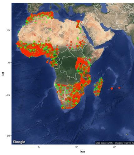
7 Afrobarometer Round 6 ( ) Field surveys 36 African countries 7022 enumeration areas (EAs) surveyor-assessed measures of access to basic infrastructure (piped water, sewerage, etc.) eapipedwater: long
 # bands 6 5 resolution 30m")

8 Satellite Imagery satellite Landsat 8 (l8) Sentinel 1 (s1) # bands 6 5 resolution 30m 15m original image size 500 x 500 pixels 500 x 500 pixels interpretation reflectance backscatter
9 6 Band Landsat 8 Results Meaningful predictions, far surpassing random chance and with ROCs good quality. Best performance on sewerage, electricity, and piped water access. Weak performance on fields hard to detect from imagery. On par with state of the art classification results (Albert et al 2017, Value Balance Accuracy F1 ROC Sewerage Electricity Piped Water Road Post Office Bank
10 Step 2: Using the new measures to fight poverty Apply trained CNN on all inhabited pixels on the African continent Generate predictions Study distribution Targeting -- Areas lagging behind? Determinants of infrastructure placement, patronage, ethnic politics
11 Step 2: Using the new measures to fight poverty Work in progress Stay tuned!
12 Appendix Slides

13 Relevant Metrics F1-score (F1) Area under ROC curve (ROC) probability that classifier will rank a randomly chosen positive example higher than a randomly chosen negative example
14 6 Band Landsat 8 Results Meaningful predictions, far surpassing random chance and with ROCs good quality. Best performance on sewerage, electricity, and piped water access. Weak performance on fields hard to detect from imagery. On par with state of the art classification results (Albert et al 2017, Value Balance Accuracy F1 ROC Sewerage Electricity Piped Water Road Post Office Bank

15 6 Band Landsat 8 Results eapipedwater:
16 Comparing to Baselines: OSM Model Value Balance Accuracy F1 ROC Sewerage Electricity Piped Water OSM Baseline Value Balance Accuracy F1 ROC Sewerage Electricity Piped Water The Model surpasses the OSM baseline on all three of its most successful measures.
17 Comparing to Baselines: Nightlights Model Value Balance Accuracy F1 ROC Sewerage Electricity Piped Water Nightlights Baseline Value Balance Accuracy F1 ROC Sewerage Electricity Piped Water The model surpasses nightlights, even on electricity.
18 Comparing to Baselines: Oracle Model Value Balance Accuracy F1 ROC Sewerage Electricity Piped Water Oracle Value Balance Accuracy F1 ROC Sewerage Electricity Piped Water The model is on par with the Oracle, demonstrating that is finding almost as much signal as it can.
19 This quarter,
20 Goals Inclusion of previous Afrobarometer Rounds Scaling project with OSM Data Model interpretability Experiments for the Paper
21 Afrobarometer Tasks: 1. Improve base model with previous rounds of the Afrobarometer dataset 2. Predict previous time spans from future time spans (predict rounds 1-3 with rounds 4-6) 3. Test for temporal aspects in repeat areas (if there are any)
22 DeepOSM for Infrastructure Premise, Afrobarometer dataset remains limited and noisy (quality is subjective) OSM might be the best chance to scale this project (infrastructure is a huge category and we should leverage all existing sources) Google Static Maps API (25,000 free images / day) has satellite images at all scales
23 Proposal Choose the most relevant tags in OSM related to infrastructure Align tags with satellite imagery Use R-CNN to detect tags Then, use all Afrobarometer rounds as validation data Open question: how to relate trained OSM model to Afrobarometer prediction
24 Model Interpretability Tasks: 1. Salience maps 2. Attention layers 3. Interpretable CNNs
25 Experiments Tasks: 1. Country holdout 2. One-shot learning in new countries 3. Temporal forecasting
arxiv: v1 [stat.ml] 10 Nov 2017
![arxiv: v1 [stat.ml] 10 Nov 2017](/thumbs/95/123582764.jpg "arxiv: v1 [stat.ml] 10 Nov 2017") Poverty Prediction with Public Landsat 7 Satellite Imagery and Machine Learning arxiv:1711.03654v1 [stat.ml] 10 Nov 2017 Anthony Perez Department of Computer Science Stanford, CA 94305 aperez8@stanford.edu
Poverty Prediction with Public Landsat 7 Satellite Imagery and Machine Learning arxiv:1711.03654v1 [stat.ml] 10 Nov 2017 Anthony Perez Department of Computer Science Stanford, CA 94305 aperez8@stanford.edu
Machine Learning and Decision Making for Sustainability
 Machine Learning and Decision Making for Sustainability Stefano Ermon Department of Computer Science Stanford University April 12 Overview Stanford Artificial Intelligence Lab Fellow, Woods Institute for
The Art of Neural Nets
 The Art of Neural Nets Marco Tavora marcotav65@gmail.com Preamble The challenge of recognizing artists given their paintings has been, for a long time, far beyond the capability of algorithms. Recent advances
Deep Learning. Dr. Johan Hagelbäck.
 Deep Learning Dr. Johan Hagelbäck johan.hagelback@lnu.se http://aiguy.org Image Classification Image classification can be a difficult task Some of the challenges we have to face are: Viewpoint variation:
Reinforcement Learning Agent for Scrolling Shooter Game
 Reinforcement Learning Agent for Scrolling Shooter Game Peng Yuan (pengy@stanford.edu) Yangxin Zhong (yangxin@stanford.edu) Zibo Gong (zibo@stanford.edu) 1 Introduction and Task Definition 1.1 Game Agent
Quick, Draw! Doodle Recognition
 Quick, Draw! Doodle Recognition Kristine Guo Stanford University kguo98@stanford.edu James WoMa Stanford University jaywoma@stanford.edu Eric Xu Stanford University ericxu0@stanford.edu Abstract Doodle
Creating an Agent of Doom: A Visual Reinforcement Learning Approach
 Creating an Agent of Doom: A Visual Reinforcement Learning Approach Michael Lowney Department of Electrical Engineering Stanford University mlowney@stanford.edu Robert Mahieu Department of Electrical Engineering
Raster is faster but vector is corrector
 Account not required Raster is faster but vector is corrector The old GIS adage raster is faster but vector is corrector comes from the two different fundamental GIS models: vector and raster. Each of
Lesson 9: Multitemporal Analysis
 Lesson 9: Multitemporal Analysis Lesson Description Multitemporal change analyses require the identification of features and measurement of their change through time. In this lesson, we will examine vegetation
arxiv: v1 [cs.lg] 2 Jan 2018
![arxiv: v1 [cs.lg] 2 Jan 2018](/thumbs/89/98840529.jpg "arxiv: v1 [cs.lg] 2 Jan 2018") Deep Learning for Identifying Potential Conceptual Shifts for Co-creative Drawing arxiv:1801.00723v1 [cs.lg] 2 Jan 2018 Pegah Karimi pkarimi@uncc.edu Kazjon Grace The University of Sydney Sydney, NSW 2006
Deep Learning for Identifying Potential Conceptual Shifts for Co-creative Drawing arxiv:1801.00723v1 [cs.lg] 2 Jan 2018 Pegah Karimi pkarimi@uncc.edu Kazjon Grace The University of Sydney Sydney, NSW 2006
an AI for Slither.io
 an AI for Slither.io Jackie Yang(jackiey) Introduction Game playing is a very interesting topic area in Artificial Intelligence today. Most of the recent emerging AI are for turn-based game, like the very
WGISS-42 USGS Agency Report
 WGISS-42 USGS Agency Report U.S. Department of the Interior U.S. Geological Survey Kristi Kline USGS EROS Center Major Activities Landsat Archive/Distribution Changes Land Change Monitoring, Assessment,
CROSS-LAYER FEATURES IN CONVOLUTIONAL NEURAL NETWORKS FOR GENERIC CLASSIFICATION TASKS. Kuan-Chuan Peng and Tsuhan Chen
 CROSS-LAYER FEATURES IN CONVOLUTIONAL NEURAL NETWORKS FOR GENERIC CLASSIFICATION TASKS Kuan-Chuan Peng and Tsuhan Chen Cornell University School of Electrical and Computer Engineering Ithaca, NY 14850
Lecture 23 Deep Learning: Segmentation
 Lecture 23 Deep Learning: Segmentation COS 429: Computer Vision Thanks: most of these slides shamelessly adapted from Stanford CS231n: Convolutional Neural Networks for Visual Recognition Fei-Fei Li, Andrej
JECAM/SEN2AGRI CROSS SITES
 JECAM/SEN2AGRI CROSS SITES BENCHMARKING FOR CROP TYPE JECAM Annual Science Meeting 16-17 November 2015 Brussels, Belgium Sen2-Agri QR Meeting -ESRIN -October 30, 2015 CROP-TYPE PRODUCT Delivered as soon
APCAS/10/21 April 2010 ASIA AND PACIFIC COMMISSION ON AGRICULTURAL STATISTICS TWENTY-THIRD SESSION. Siem Reap, Cambodia, April 2010
 APCAS/10/21 April 2010 Agenda Item 8 ASIA AND PACIFIC COMMISSION ON AGRICULTURAL STATISTICS TWENTY-THIRD SESSION Siem Reap, Cambodia, 26-30 April 2010 The Use of Remote Sensing for Area Estimation by Robert
NU-Net: Deep Residual Wide Field of View Convolutional Neural Network for Semantic Segmentation
 NU-Net: Deep Residual Wide Field of View Convolutional Neural Network for Semantic Segmentation Mohamed Samy 1 Karim Amer 1 Kareem Eissa Mahmoud Shaker Mohamed ElHelw Center for Informatics Science Nile
Biologically Inspired Computation
 Biologically Inspired Computation Deep Learning & Convolutional Neural Networks Joe Marino biologically inspired computation biological intelligence flexible capable of detecting/ executing/reasoning about
Remote Sensing in an
 Chapter 6: Displaying Data Remote Sensing in an ArcMap Environment Remote Sensing Analysis in an ArcMap Environment Tammy E. Parece Image source: landsat.usgs.gov Tammy Parece James Campbell John McGee
Derek Allman a, Austin Reiter b, and Muyinatu Bell a,c
 Exploring the effects of transducer models when training convolutional neural networks to eliminate reflection artifacts in experimental photoacoustic images Derek Allman a, Austin Reiter b, and Muyinatu
Tiny ImageNet Challenge Investigating the Scaling of Inception Layers for Reduced Scale Classification Problems
 Tiny ImageNet Challenge Investigating the Scaling of Inception Layers for Reduced Scale Classification Problems Emeric Stéphane Boigné eboigne@stanford.edu Jan Felix Heyse heyse@stanford.edu Abstract Scaling
USGS Welcome. 38 th CEOS Working Group on Calibration and Validation Plenary (WGCV-38)
") Landsat 5 USGS Welcome Prepared for 38 th CEOS Working Group on Calibration and Validation Plenary (WGCV-38) Presenter Tom Cecere International Liaison USGS Land Remote Sensing Program Elephant Butte Reservoir
Landsat 5 USGS Welcome Prepared for 38 th CEOS Working Group on Calibration and Validation Plenary (WGCV-38) Presenter Tom Cecere International Liaison USGS Land Remote Sensing Program Elephant Butte Reservoir
Using Artificial intelligent to solve the game of 2048
 Using Artificial intelligent to solve the game of 2048 Ho Shing Hin (20343288) WONG, Ngo Yin (20355097) Lam Ka Wing (20280151) Abstract The report presents the solver of the game 2048 base on artificial
Convolutional Neural Networks
 Convolutional Neural Networks Convolution, LeNet, AlexNet, VGGNet, GoogleNet, Resnet, DenseNet, CAM, Deconvolution Sept 17, 2018 Aaditya Prakash Convolution Convolution Demo Convolution Convolution in
GPU ACCELERATED DEEP LEARNING WITH CUDNN
 GPU ACCELERATED DEEP LEARNING WITH CUDNN Larry Brown Ph.D. March 2015 AGENDA 1 Introducing cudnn and GPUs 2 Deep Learning Context 3 cudnn V2 4 Using cudnn 2 Introducing cudnn and GPUs 3 HOW GPU ACCELERATION
Mapping Open Water Bodies with Optical Remote Sensing
 Mapping Open Water Bodies with Optical Remote Sensing M. O Donnell 1,2 and E. Podest 1 1.Jet Propulsion Laboratory, California Institute of Technology 2 Alliance Gertz-Ressler High School, Los Angeles,
IBM SPSS Neural Networks
 IBM Software IBM SPSS Neural Networks 20 IBM SPSS Neural Networks New tools for building predictive models Highlights Explore subtle or hidden patterns in your data. Build better-performing models No programming
Research on Hand Gesture Recognition Using Convolutional Neural Network
 Research on Hand Gesture Recognition Using Convolutional Neural Network Tian Zhaoyang a, Cheng Lee Lung b a Department of Electronic Engineering, City University of Hong Kong, Hong Kong, China E-mail address:
Suneel Marthi Jose Luis Contreras. June 11, 2018 Berlin Buzzwords, Berlin, Germany
 Large Scale Landuse Classification of Satellite Imagery Suneel Marthi Jose Luis Contreras June 11, 2018 Berlin Buzzwords, Berlin, Germany 1 Agenda Introduction Satellite Image Data Description Cloud Classification
Land Cover Analysis to Determine Areas of Clear-cut and Forest Cover in Olney, Montana. Geob 373 Remote Sensing. Dr Andreas Varhola, Kathry De Rego
 1 Land Cover Analysis to Determine Areas of Clear-cut and Forest Cover in Olney, Montana Geob 373 Remote Sensing Dr Andreas Varhola, Kathry De Rego Zhu an Lim (14292149) L2B 17 Apr 2016 2 Abstract Montana
Classification in Image processing: A Survey
 Classification in Image processing: A Survey Rashmi R V, Sheela Sridhar Department of computer science and Engineering, B.N.M.I.T, Bangalore-560070 Department of computer science and Engineering, B.N.M.I.T,
Colorful Image Colorizations Supplementary Material
 Colorful Image Colorizations Supplementary Material Richard Zhang, Phillip Isola, Alexei A. Efros {rich.zhang, isola, efros}@eecs.berkeley.edu University of California, Berkeley 1 Overview This document
Satellite Imagery and Remote Sensing. DeeDee Whitaker SW Guilford High EES & Chemistry
 Satellite Imagery and Remote Sensing DeeDee Whitaker SW Guilford High EES & Chemistry whitakd@gcsnc.com Outline What is remote sensing? How does remote sensing work? What role does the electromagnetic
Comparison of Google Image Search and ResNet Image Classification Using Image Similarity Metrics
 University of Arkansas, Fayetteville ScholarWorks@UARK Computer Science and Computer Engineering Undergraduate Honors Theses Computer Science and Computer Engineering 5-2018 Comparison of Google Image
THE problem of automating the solving of
 CS231A FINAL PROJECT, JUNE 2016 1 Solving Large Jigsaw Puzzles L. Dery and C. Fufa Abstract This project attempts to reproduce the genetic algorithm in a paper entitled A Genetic Algorithm-Based Solver
CS688/WST665 Student presentation Learning Fine-grained Image Similarity with Deep Ranking CVPR Gayoung Lee ( 이가영 )
") CS688/WST665 Student presentation Learning Fine-grained Image Similarity with Deep Ranking CVPR 2014 Gayoung Lee ( 이가영 ) Contents 1. Background knowledge 2. Proposed method 3. Experimental Result 4. Conclusion
CS688/WST665 Student presentation Learning Fine-grained Image Similarity with Deep Ranking CVPR 2014 Gayoung Lee ( 이가영 ) Contents 1. Background knowledge 2. Proposed method 3. Experimental Result 4. Conclusion
arxiv: v1 [cs.ce] 9 Jan 2018
![arxiv: v1 [cs.ce] 9 Jan 2018](/thumbs/77/76232406.jpg "arxiv: v1 [cs.ce] 9 Jan 2018") Predict Forex Trend via Convolutional Neural Networks Yun-Cheng Tsai, 1 Jun-Hao Chen, 2 Jun-Jie Wang 3 arxiv:1801.03018v1 [cs.ce] 9 Jan 2018 1 Center for General Education 2,3 Department of Computer Science
Predict Forex Trend via Convolutional Neural Networks Yun-Cheng Tsai, 1 Jun-Hao Chen, 2 Jun-Jie Wang 3 arxiv:1801.03018v1 [cs.ce] 9 Jan 2018 1 Center for General Education 2,3 Department of Computer Science
Learning to Predict Indoor Illumination from a Single Image. Chih-Hui Ho
 Learning to Predict Indoor Illumination from a Single Image Chih-Hui Ho 1 Outline Introduction Method Overview LDR Panorama Light Source Detection Panorama Recentering Warp Learning From LDR Panoramas
GIS Data Collection. Remote Sensing
 GIS Data Collection Remote Sensing Data Collection Remote sensing Introduction Concepts Spectral signatures Resolutions: spectral, spatial, temporal Digital image processing (classification) Other systems
First Exam. Geographers Tools: Gathering Information. Photographs and Imagery. SPIN 2 Image of Downtown Atlanta, GA 1995 REMOTE SENSING 9/19/2016
 First Exam Geographers Tools: Gathering Information Prof. Anthony Grande Hunter College Geography Lecture design, content and presentation AFG 0616. Individual images and illustrations may be subject to
GESTURE RECOGNITION FOR ROBOTIC CONTROL USING DEEP LEARNING
 2017 NDIA GROUND VEHICLE SYSTEMS ENGINEERING AND TECHNOLOGY SYMPOSIUM AUTONOMOUS GROUND SYSTEMS (AGS) TECHNICAL SESSION AUGUST 8-10, 2017 - NOVI, MICHIGAN GESTURE RECOGNITION FOR ROBOTIC CONTROL USING
RESEARCH, MONITORING AND EVALUATION
 RESEARCH, MONITORING AND EVALUATION We worked with 12 communities and 148 programs to follow 2,282 families (with 5,397 children) over three years to produce rigorous evidence towards solving homelessness.
JUMPSTARTING NEURAL NETWORK TRAINING FOR SEISMIC PROBLEMS
 JUMPSTARTING NEURAL NETWORK TRAINING FOR SEISMIC PROBLEMS Fantine Huot (Stanford Geophysics) Advised by Greg Beroza & Biondo Biondi (Stanford Geophysics & ICME) LEARNING FROM DATA Deep learning networks
Green/Blue Metrics Meeting June 20, 2017 Summary
 Short round table introductions of participants Paul Villenueve, Carleton, Co-lead Green/Blue, Matilda van den Bosch, UBC, Co-lead Green/Blue Dan Crouse, UNB Lorien Nesbitt, UBC Audrey Smargiassi, Uof
Cellular automata applied in remote sensing to implement contextual pseudo-fuzzy classication - The Ninth International Conference on Cellular
 INDEX Introduction Spectral and Contextual Classification of Satellite Images Classical aplications of Cellular Automata in Remote Sensing Classification of Satellite Images with Cellular Automata (ACA)
Project summary. Key findings, Winter: Key findings, Spring:
 Summary report: Assessing Rusty Blackbird habitat suitability on wintering grounds and during spring migration using a large citizen-science dataset Brian S. Evans Smithsonian Migratory Bird Center October
arxiv: v1 [cs.cv] 19 Jun 2017
![arxiv: v1 [cs.cv] 19 Jun 2017](/thumbs/80/81286554.jpg "arxiv: v1 [cs.cv] 19 Jun 2017") Satellite Imagery Feature Detection using Deep Convolutional Neural Network: A Kaggle Competition Vladimir Iglovikov True Accord iglovikov@gmail.com Sergey Mushinskiy Open Data Science cepera.ang@gmail.com
Satellite Imagery Feature Detection using Deep Convolutional Neural Network: A Kaggle Competition Vladimir Iglovikov True Accord iglovikov@gmail.com Sergey Mushinskiy Open Data Science cepera.ang@gmail.com
CS221 Project Final Report Deep Q-Learning on Arcade Game Assault
 CS221 Project Final Report Deep Q-Learning on Arcade Game Assault Fabian Chan (fabianc), Xueyuan Mei (xmei9), You Guan (you17) Joint-project with CS229 1 Introduction Atari 2600 Assault is a game environment
Introduction. Introduction. Introduction. Introduction. Introduction
 Identifying habitat change and conservation threats with satellite imagery Extinction crisis Volker Radeloff Department of Forest Ecology and Management Extinction crisis Extinction crisis Conservationists
Remote sensing monitoring of coastline change in Pearl River estuary
 Remote sensing monitoring of coastline change in Pearl River estuary Xiaoge Zhu Remote Sensing Geology Department Research Institute of Petroleum Exploration and Development (RIPED) PetroChina Company
University of Bristol - Explore Bristol Research. Peer reviewed version. Link to publication record in Explore Bristol Research PDF-document
 Hepburn, A., McConville, R., & Santos-Rodriguez, R. (2017). Album cover generation from genre tags. Paper presented at 10th International Workshop on Machine Learning and Music, Barcelona, Spain. Peer
SUGAR_GIS. From a user perspective. Provides spatial distribution of a wide range of sugarcane production data in an easy to use and sensitive way.
 SUGAR_GIS From a user perspective What is Sugar_GIS? A web-based, decision support tool. Provides spatial distribution of a wide range of sugarcane production data in an easy to use and sensitive way.
Remote Sensing in an
 Chapter 20: Accuracy Assessment Remote Sensing in an ArcMap Environment Remote Sensing Analysis in an ArcMap Environment Tammy E. Parece Image source: landsat.usgs.gov Tammy Parece James Campbell John
DeCAF: A Deep Convolutional Activation Feature for Generic Visual Recognition. ECE 289G: Paper Presentation #3 Philipp Gysel
 DeCAF: A Deep Convolutional Activation Feature for Generic Visual Recognition ECE 289G: Paper Presentation #3 Philipp Gysel Autonomous Car ECE 289G Paper Presentation, Philipp Gysel Slide 2 Source: maps.google.com
Introduction to Machine Learning
 Introduction to Machine Learning Deep Learning Barnabás Póczos Credits Many of the pictures, results, and other materials are taken from: Ruslan Salakhutdinov Joshua Bengio Geoffrey Hinton Yann LeCun 2
DISTINGUISHING URBAN BUILT-UP AND BARE SOIL FEATURES FROM LANDSAT 8 OLI IMAGERY USING DIFFERENT DEVELOPED BAND INDICES
 DISTINGUISHING URBAN BUILT-UP AND BARE SOIL FEATURES FROM LANDSAT 8 OLI IMAGERY USING DIFFERENT DEVELOPED BAND INDICES Mark Daryl C. Janiola (1), Jigg L. Pelayo (1), John Louis J. Gacad (1) (1) Central
Digital Image Processing
 Digital Image Processing 1 Patrick Olomoshola, 2 Taiwo Samuel Afolayan 1,2 Surveying & Geoinformatic Department, Faculty of Environmental Sciences, Rufus Giwa Polytechnic, Owo. Nigeria Abstract: This paper
Predicting outcomes of professional DotA 2 matches
 Predicting outcomes of professional DotA 2 matches Petra Grutzik Joe Higgins Long Tran December 16, 2017 Abstract We create a model to predict the outcomes of professional DotA 2 (Defense of the Ancients
Driving Using End-to-End Deep Learning
 Driving Using End-to-End Deep Learning Farzain Majeed farza@knights.ucf.edu Kishan Athrey kishan.athrey@knights.ucf.edu Dr. Mubarak Shah shah@crcv.ucf.edu Abstract This work explores the problem of autonomously
THE aesthetic quality of an image is judged by commonly
 1 Image Aesthetic Assessment: An Experimental Survey Yubin Deng, Chen Change Loy, Member, IEEE, and Xiaoou Tang, Fellow, IEEE arxiv:1610.00838v1 [cs.cv] 4 Oct 2016 Abstract This survey aims at reviewing
First Exam: Thurs., Sept 28
 8 Geographers Tools: Gathering Information Prof. Anthony Grande Hunter College Geography Lecture design, content and presentation AFG 0917. Individual images and illustrations may be subject to prior copyright.
BIG DATA EUROPE TRANSPORT PILOT: INTRODUCING THESSALONIKI. Josep Maria Salanova Grau CERTH-HIT
 BIG DATA EUROPE TRANSPORT PILOT: INTRODUCING THESSALONIKI Josep Maria Salanova Grau CERTH-HIT Thessaloniki on the map ~ 1.400.000 inhabitants & ~ 1.300.000 daily trips ~450.000 private cars & ~ 20.000
Playing CHIP-8 Games with Reinforcement Learning
 Playing CHIP-8 Games with Reinforcement Learning Niven Achenjang, Patrick DeMichele, Sam Rogers Stanford University Abstract We begin with some background in the history of CHIP-8 games and the use of
Sommersemester Prof. Dr. Christoph Kleinn Institut für Waldinventur und Waldwachstum Arbeitsbereich Fernerkundung und Waldinventur.
 Basics of Remote Sensing Some literature references Franklin, SE 2001 Remote Sensing for Sustainable Forest Management Lewis Publishers 407p Lillesand, Kiefer 2000 Remote Sensing and Image Interpretation
Lecture 11-1 CNN introduction. Sung Kim
 Lecture 11-1 CNN introduction Sung Kim 'The only limit is your imagination' http://itchyi.squarespace.com/thelatest/2012/5/17/the-only-limit-is-your-imagination.html Lecture 7: Convolutional
SketchNet: Sketch Classification with Web Images[CVPR `16]
![SketchNet: Sketch Classification with Web Images[CVPR `16]](/thumbs/95/126342773.jpg "SketchNet: Sketch Classification with Web Images[CVPR `16]") SketchNet: Sketch Classification with Web Images[CVPR `16] CS688 Paper Presentation 1 Doheon Lee 20183398 2018. 10. 23 Table of Contents Introduction Background SketchNet Result 2 Introduction Properties
SketchNet: Sketch Classification with Web Images[CVPR `16] CS688 Paper Presentation 1 Doheon Lee 20183398 2018. 10. 23 Table of Contents Introduction Background SketchNet Result 2 Introduction Properties
Efficient Deep Learning in Communications
 Fraunhofer Image Processing Heinrich Hertz Institute Efficient Deep Learning in Communications Dr. Wojciech Samek Fraunhofer HHI, Machine Learning Group Fraunhofer Heinrich Hertz Institute, Einsteinufer
Using registers E-enumeration and CAPI Electronic map. Census process. E-enumeration. Census moment and census period E-enumeration process
 COMBINED CENSUS METHODOLOGY IN 2011 CENSUS IN ESTONIA Diana Beltadze Statistics Estonia Content Choice of methodology Using registers E-enumeration and CAPI Electronic map Census process. E-enumeration
Machine Learning for Intelligent Transportation Systems
 Machine Learning for Intelligent Transportation Systems Patrick Emami (CISE), Anand Rangarajan (CISE), Sanjay Ranka (CISE), Lily Elefteriadou (CE) MALT Lab, UFTI September 6, 2018 ITS - A Broad Perspective
Neural Networks The New Moore s Law
 Neural Networks The New Moore s Law Chris Rowen, PhD, FIEEE CEO Cognite Ventures December 216 Outline Moore s Law Revisited: Efficiency Drives Productivity Embedded Neural Network Product Segments Efficiency
TEMPORAL ANALYSIS OF MULTI EPOCH LANDSAT GEOCOVER IMAGES IN ZONGULDAK TESTFIELD
 TEMPORAL ANALYSIS OF MULTI EPOCH LANDSAT GEOCOVER IMAGES IN ZONGULDAK TESTFIELD Şahin, H. a*, Oruç, M. a, Büyüksalih, G. a a Zonguldak Karaelmas University, Zonguldak, Turkey - (sahin@karaelmas.edu.tr,
Warren Cartwright, Product Manager MDA Geospatial Services, Canada
 Advanced InSAR Techniques for Urban Infrastructure Monitoring Warren Cartwright, Product Manager MDA Geospatial Services, Canada www.mdacorporation.com RESTRICTION ON USE, PUBLICATION OR DISCLOSURE OF
GE 113 REMOTE SENSING
 GE 113 REMOTE SENSING Topic 8. Image Classification and Accuracy Assessment Lecturer: Engr. Jojene R. Santillan jrsantillan@carsu.edu.ph Division of Geodetic Engineering College of Engineering and Information
First Exam: New Date. 7 Geographers Tools: Gathering Information. Photographs and Imagery REMOTE SENSING 2/23/2018. Friday, March 2, 2018.
 First Exam: New Date Friday, March 2, 2018. Combination of multiple choice questions and map interpretation. Bring a #2 pencil with eraser. Based on class lectures supplementing chapter 1. Review lecture
Autocomplete Sketch Tool
 Autocomplete Sketch Tool Sam Seifert, Georgia Institute of Technology Advanced Computer Vision Spring 2016 I. ABSTRACT This work details an application that can be used for sketch auto-completion. Sketch
Satellite Imagery and an ABS Methodology for Predicting Crop Yields
 1 - Satellite Imagery and an ABS Methodology for Predicting Crop Yields Dr Siu-Ming Tam Chief Methodologist Global WG on Big Data Beijing, China October, 2014 2 Outline Caveats I. Expert? II. Methodology
Dependency-based Convolutional Neural Networks for Sentence Embedding
 Dependency-based Convolutional Neural Networks for Sentence Embedding ROOT? Mingbo Ma Liang Huang CUNY Bing Xiang Bowen Zhou IBM T. J. Watson ACL 2015 Beijing Convolutional Neural Network for NLP Kalchbrenner
Part 1. Tracing the Dimensions of Some Common Pixel Sizes using a GPS Receiver
 Field and Laboratory Exercise PIXEL DELINEATIONS 1 IMPORTING GPS DATA TO IMAGE BACKGROUND Objectives: 1. Demonstrate the differences in spatial resolution of selected remote sensing instruments. 2. Use
Land cover change methods. Ned Horning
 Land cover change methods Ned Horning Version: 1.0 Creation Date: 2004-01-01 Revision Date: 2004-01-01 License: This document is licensed under a Creative Commons Attribution-Share Alike 3.0 Unported License.
Adversarial Attacks on Face Detectors using Neural Net based Constrained Optimization
 Adversarial Attacks on Face Detectors using Neural Net based Constrained Optimization Joey Bose University of Toronto joey.bose@mail.utoronto.ca September 26, 2018 Joey Bose (UofT) GeekPwn Las Vegas September
Automatic Image Cropping and Selection using Saliency: an Application to Historical Manuscripts
 Automatic Image Cropping and Selection using Saliency: an Application to Historical Manuscripts Marcella Cornia, Stefano Pini, Lorenzo Baraldi, and Rita Cucchiara University of Modena and Reggio Emilia
Artificial Intelligence Machine learning and Deep Learning: Trends and Tools. Dr. Shaona
 Artificial Intelligence Machine learning and Deep Learning: Trends and Tools Dr. Shaona Ghosh @shaonaghosh What is Machine Learning? Computer algorithms that learn patterns in data automatically from large
Radio Deep Learning Efforts Showcase Presentation
 Radio Deep Learning Efforts Showcase Presentation November 2016 hume@vt.edu www.hume.vt.edu Tim O Shea Senior Research Associate Program Overview Program Objective: Rethink fundamental approaches to how
Visualizing a Pixel. Simulate a Sensor s View from Space. In this activity, you will:
 Simulate a Sensor s View from Space In this activity, you will: Measure and mark pixel boundaries Learn about spatial resolution, pixels, and satellite imagery Classify land cover types Gain exposure to
Preparing Remote Sensing Data for Natural Resources Mapping (image enhancement, rectifications )
") Preparing Remote Sensing Data for Natural Resources Mapping (image enhancement, rectifications ) Why is this important What are the major approaches Examples of digital image enhancement Follow up exercises
Preparing Remote Sensing Data for Natural Resources Mapping (image enhancement, rectifications ) Why is this important What are the major approaches Examples of digital image enhancement Follow up exercises
CHARACTERISTICS OF REMOTELY SENSED IMAGERY. Radiometric Resolution
 CHARACTERISTICS OF REMOTELY SENSED IMAGERY Radiometric Resolution There are a number of ways in which images can differ. One set of important differences relate to the various resolutions that images express.
Use of Big Data in Environmental Evaluation
 FOCUS SESSION ON USE OF NEW TECHNOLOGIES IN M&E AND IMPLICATIONS FOR EVALUATION Use of Big Data in Environmental Evaluation World Bank 19th Meeting of the DAC Network on Development Evaluation 26-27 April
SDCG-5 Session 2. Landsat 7/8 status and 2013 Implementation Plan (Element 1)
") Session 2 Landsat 7/8 status and 2013 Implementation Plan (Element 1) Gene Fosnight Mission Landsat Launch and commissioning Landsat 7 Operational: since 15 April 1999 Expected life time:; anticipate decommissioning
Session 2 Landsat 7/8 status and 2013 Implementation Plan (Element 1) Gene Fosnight Mission Landsat Launch and commissioning Landsat 7 Operational: since 15 April 1999 Expected life time:; anticipate decommissioning
Deep learning architectures for music audio classification: a personal (re)view
view") Deep learning architectures for music audio classification: a personal (re)view Jordi Pons jordipons.me @jordiponsdotme Music Technology Group Universitat Pompeu Fabra, Barcelona Acronyms MLP: multi layer
Deep learning architectures for music audio classification: a personal (re)view Jordi Pons jordipons.me @jordiponsdotme Music Technology Group Universitat Pompeu Fabra, Barcelona Acronyms MLP: multi layer
THE aesthetic quality of an image is judged by commonly
 1 Image Aesthetic Assessment: An Experimental Survey Yubin Deng, Chen Change Loy, Member, IEEE, and Xiaoou Tang, Fellow, IEEE arxiv:1610.00838v2 [cs.cv] 20 Apr 2017 Abstract This survey aims at reviewing
WITH continuous miniaturization of silicon technology
 IEEE TRANSACTIONS ON IMAGE PROCESSING, VOL. X., X. 8, MONTH 20XX 1 Leveraging expert feature knowledge for predicting image aesthetics Michal Kucer, Student Member, IEEE, Alexander C. Loui, Fellow, IEEE,
Caatinga - Appendix. Collection 3. Version 1. General coordinator Washington J. S. Franca Rocha (UEFS)
") Caatinga - Appendix Collection 3 Version 1 General coordinator Washington J. S. Franca Rocha (UEFS) Team Diego Pereira Costa (UEFS/GEODATIN) Frans Pareyn (APNE) José Luiz Vieira (APNE) Rodrigo N. Vasconcelos
Caatinga - Appendix Collection 3 Version 1 General coordinator Washington J. S. Franca Rocha (UEFS) Team Diego Pereira Costa (UEFS/GEODATIN) Frans Pareyn (APNE) José Luiz Vieira (APNE) Rodrigo N. Vasconcelos
Deformable Convolutional Networks
 Deformable Convolutional Networks Jifeng Dai^ With Haozhi Qi*^, Yuwen Xiong*^, Yi Li*^, Guodong Zhang*^, Han Hu, Yichen Wei Visual Computing Group Microsoft Research Asia (* interns at MSRA, ^ equal contribution)
Augmenting Self-Learning In Chess Through Expert Imitation
 Augmenting Self-Learning In Chess Through Expert Imitation Michael Xie Department of Computer Science Stanford University Stanford, CA 94305 xie@cs.stanford.edu Gene Lewis Department of Computer Science
Convolutional Neural Networks for Small-footprint Keyword Spotting
 INTERSPEECH 2015 Convolutional Neural Networks for Small-footprint Keyword Spotting Tara N. Sainath, Carolina Parada Google, Inc. New York, NY, U.S.A {tsainath, carolinap}@google.com Abstract We explore
CAT Training CNNs for Image Classification with Noisy Labels
 yclic Annealing Training (AT) NNs for Image lassification with Noisy Labels JiaWei Li, Tao Dai, QingTao Tang, YeLi Xing, Shu-Tao Xia Tsinghua University li-jw15@mailstsinghuaeducn October 8, 2018 AT Training
Detection and Segmentation. Fei-Fei Li & Justin Johnson & Serena Yeung. Lecture 11 -
 Lecture 11: Detection and Segmentation Lecture 11-1 May 10, 2017 Administrative Midterms being graded Please don t discuss midterms until next week - some students not yet taken A2 being graded Project
Reinventing movies How do we tell stories in VR? Diego Gutierrez Graphics & Imaging Lab Universidad de Zaragoza
 Reinventing movies How do we tell stories in VR? Diego Gutierrez Graphics & Imaging Lab Universidad de Zaragoza Computer Graphics Computational Imaging Virtual Reality Joint work with: A. Serrano, J. Ruiz-Borau
Convolutional Networks for Image Segmentation: U-Net 1, DeconvNet 2, and SegNet 3
 Convolutional Networks for Image Segmentation: U-Net 1, DeconvNet 2, and SegNet 3 1 Olaf Ronneberger, Philipp Fischer, Thomas Brox (Freiburg, Germany) 2 Hyeonwoo Noh, Seunghoon Hong, Bohyung Han (POSTECH,
Dota2 is a very popular video game currently.
 Dota2 Outcome Prediction Zhengyao Li 1, Dingyue Cui 2 and Chen Li 3 1 ID: A53210709, Email: zhl380@eng.ucsd.edu 2 ID: A53211051, Email: dicui@eng.ucsd.edu 3 ID: A53218665, Email: lic055@eng.ucsd.edu March