SURVEYOR S REPORT VERTICAL CONTROL FOR CONSTRUCTION C-44 PROJECT
|
|
|
- Ralph Hensley
- 5 years ago
- Views:
Transcription

1 Post Office Box 1469 Palm City, FL Martin: Fax: Statewide: SURVEYOR S REPORT VERTICAL CONTROL FOR CONSTRUCTION C-44 PROJECT The purpose of this effort was to establish vertical control for the STA construction project at the C-44 project site per the following specifications: 1. The specifications were to construct two (2) National Geodetic Survey (NGS) Class B rod marks. The marks shall be 9/16 stainless steel rod driven to refusal or 80 feet, whichever occurs first. The marks shall include NGS style Access Covers with designations stamped in space provide on lid. Marks will be constructed to NGS specifications. (NOAA Manual NOS NGS 1 Geodetic Bench Marks). 2. Locations of new marks to be near the following geographical locations: a N, W b N, W. c. Actual locations to be field determined and approved by the District s Project Surveyor and Project Manager. 3. New elevations and verification of existing bench mark elevations will be determined by differential leveling beginning at NGS Bench Mark F008 (NGS PID AF7686) running through existing bench marks Allap 12, Allap 11 and Allap 10 to new bench mark a in item 2 above, continuing around the eastern side of the project area to NGS control point F012 (NGS PID AF7689) thence Southwesterly along Citrus Boulevard to existing bench mark STU APPELBAUM, continuing Southwesterly to Minute Maid Road then north along Minute Maid Road to new bench mark b in item 2 above, thence proceeding north, then west along Minute Maid road and through existing bench marks J , J and J closing on NGS bench mark E 616 (NGS PID DI6628). Two (2) cross canal connections shall be made from NGS bench mark M 522 (NGS PID AJ8247) to NGS bench mark F012 and from NGS bench mark L 522 (NGS PID AJ8246) to bench mark STU APPELBAUM. 4. All Leveling shall meet or exceed NGS 2 nd Order, Class II closure criteria. (+-8mm*sqrt of Km run or *sqrt of miles run). Also, all level runs shall meet or exceed NGS Second Order Class 2 procedures (with the exception of the blue booking process and double running of line segments). 5. Horizontal positioning of the 2 new rod marks to be determined by observing each point for a minimum of 4.0 hours and submitting the data with pictures and how to reach descriptions to NGS OPUS DB (Online Positioning Users Service Data Base) for publication of solutions in their database. The first effort was the canal crossing bench run that was performed on 10/1-10/ The run started at NGS benchmark K CERP PID AJ8260 ran through NGS benchmark L CERP PID AJ8246 checking in with feet. This segment of the bench run was
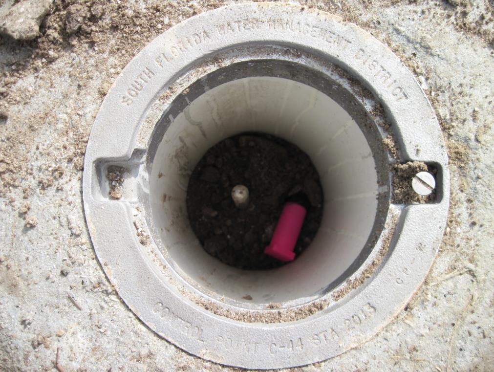
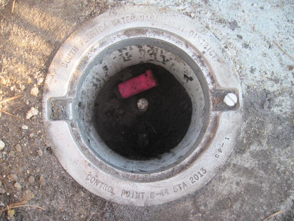
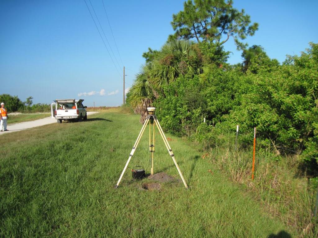
2 done using a Leica NA 3003 digital level. From the aforesaid L 522 benchmark we proceeded with the canal crossing portion of the bench run utilizing a Topcon AT-G2 self-leveling conventional level. We then set a turning point on the north top of bank of the C-44 canal. We then switched back to the NA 3003 digital level and continued the bench run through USACOE Stu Applebaum 2012 and NGS Control Point F PID AF7689. We then proceeded back to the Topcon self-leveling level and crossed back south across the C-44 Canal where we then switched back to the NA 3303 digital level. We proceeded on to NGS bench mark M CERP PID AJ8247 checking in with feet error. We then went to NGS bench mark N CERP PID AJ8248 closing with feet total error for a run of 3.92 miles. The next effort was to construct 2 NGS Class B Rod marks. This done on October 16-17, The marks are designated as South Florida Water Management District Control Point C- 44 STA 2013 CP-1 and South Florida Water Management District Control Point C-44 STA 2013 CP-2. On October 21, 2013 the 2 points were occupied with GPS receivers for approximately 5.5 hours each. This data was summited and accepted to OPUS DB on October 30, NGS PID BBDH04 and BBDH05 respectively were assigned to the 2 new marks. The bench run was started on October 14, 2013nd completed on 10/31/2013. This bench run began on NGS Control Point GS 16 PID AJ5267, ran through NGS Control Point F008 PID AF7686. The bench run then proceeded through SFWMD Bench Marks ALLAP 12, ALLAP 11, ALLAP 10 and ALLAP 9. Then through South Florida Water Management District Control Point C-44 STA 2013 CP-1 and on to NGS Control Point F PID AF7689. The bench run then proceeded through STU APPELBAUM, South Florida Water Management District Control Point C-44 STA 2013 CP-2, J , J and J closing on NGS bench mark E 616 (NGS PID DI6628) and then NGS bench mark F 616 (NGS PID DI6630). The above data was combined with digital level data from 2001 which ran from NGS Control Point GCY D08 PID AJ5250 to NGS Control Point F PID AF7689 as well as with digital level data from 2004 that commenced at NGS bench mark R 543 (NGS PID AJ8524) and went through the aforesaid bench marks GS 16, F 008, ALLAP 12, ALLAP 10 and F012 and then closed on NGS bench mark H 516 (NGS PID A524). This data was all combined and adjusted using the STARNET least squares adjusting software. The closure of the data was at ft * sqrt mile. This exceeded the required +-8mm*sqrt of Km run or *sqrt of miles run. K:\ HDR Engineers - C-44 Vertical Control\Documents\Surveyors Notes\Surveyors Report C-44 Vertical Control.docx
3 The following stations were held as fixed in the STARNET adjustment: Elev Description K CERP NGSPID AJ L CERP NGSPID AJ M CERP NGSPID AJ N CERP NGSPID AJ GCY D GS 16 NGSPID AJ F008 NGSPID AF E NGSPID DI F NGSPID DI R 543 NGSPID AJ J 543 NGSPID AJ F007 NGSPID AJ GS 15 NGSPID DI H 516 The following elevations were determined by the adjustment: Adjusted Elevation Description USACOE STU-APPLEBAUM F012 NGSPID AF SFWMD ALLAP SFWMD ALLAP SFWMD ALLAP SFWMD ALLAP SFWMD CONTROL POINT STA 2013 CP SFWMD CONTROL POINT STA 2013 CP GPS OFFSET TRAV CONTROL POINT J GPS OFFSET TRAV CONTROL POINT J GPS OFFSET TRAV CONTROL POINT J K:\ HDR Engineers - C-44 Vertical Control\Documents\Surveyors Notes\Surveyors Report C-44 Vertical Control.docx
4 Certification (Not valid without the Signature and Original Raised Seal of a Florida Licensed Surveyor and Mapper) I hereby certify that the Specific Purpose Survey of the property shown and described hereon was completed under my direction and said Survey is true and correct to the best of my knowledge and belief. I further certify that this Survey meets the Minimum Technical Standards for Surveys set forth by the Florida Board of Professional Surveyors and Mappers in Chapter 5J-17, Florida Administrative Code, pursuant to Section 472.O27 Florida Statutes. No search of the public records has been made by this office. The survey is based on information furnished by client or client's representative. 10/31/2013 Date of survey Peter Andersen Professional Surveyor and Mapper Florida Certificate No K:\ HDR Engineers - C-44 Vertical Control\Documents\Surveyors Notes\Surveyors Report C-44 Vertical Control.docx
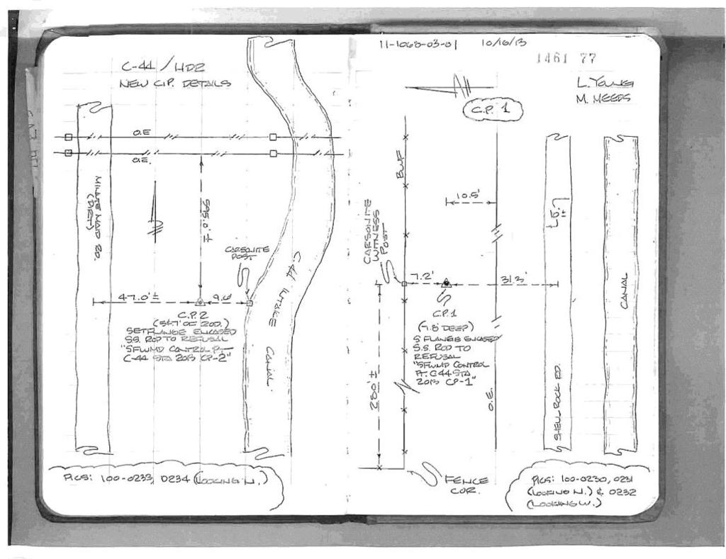
5 SURVEY DATASHEET ( Version 1.0 ) Page 1 of 1 12/27/2013 SURVEY DATASHEET (Version 1.0) PID: BBDH04 Designation: SFWMD CONTROL POINT C-44 STA 2013 CP-1 Stamping: CONTROL POINT C-44 STA 2013 CP-1 Stability: Monument will probably hold position well Setting: Galvanized steel rod without sleeve (10FT+ or 3.048M+) Description: FROM THE INTERSECTION OF SW WARFIELD BLVE (SR 710) AND SW CIRUS BLVD (CR 726) GO 4.9 MILES ALONG SW CITRUS BLVD TO AN UN-NAMED DIRT ROAD ON LEFT; THENCE NOTHERTHERLY THEN WESTERLY ON SAID UN-NAMED DIRT ROAD, FOR 4.9 MILES TO STATION ON THE RIGHT. STATION 280 FEET MORE OR LESS EAST OF A FENCE CORNER, 7.2 FEET SOUTH OF A CARSONITE POST SET IN A BARBED WIRE FENCE LINE; 10.5 FEET NORTH OF AN OVERHEAD POWERLINE AND 31 FEET NORTH OF A 10 FOOT WIDE SHELL ROCK ROAD. Observed: T13:07:00Z Source: OPUS - page Close-up View REF_FRAME: NAD_83(2011) EPOCH: SOURCE: NAVD88 (Computed using GEOID12A) UNITS: m SET PROFILE DETAILS LAT: 27 5' " ± m LON: ' " ± m ELL HT: ± m X: ± m Y: ± m Z: ± m ORTHO HT: ± m UTM 17 SPC 901(FL E) NORTHING: m m EASTING: m m CONVERGENCE: POINT SCALE: COMBINED FACTOR: CONTRIBUTED BY PETEA GCY, Incorporated SFWMD CONTROL POINT C-44 STA 2013 CP-1 Horizon View Map data 2013 Google Report a map error The numerical values for this position solution have satisfied the quality control criteria of the National Geodetic Survey. The contributor has verified that the information submitted is accurate and complete.
 PID: BBDH05 Designation: SFWMD CONTROL POINT C-44 STA 2013 CP-2 Stamping: CONTROL POINT C-44 STA 2013 CP-2 Stability: Monument will probably hold position well Setting: Stainless steel rod without")
 THENCE GO NORTH ON SAID MINUTE MAID ROAD FOR 2.0 MILES TO STATION ON RIGHT. STATION IS 47 FEET EAST OF CENTERLINE OF MINUTE MAID ROAD; 9.")
 EPOCH: 2010.0000 SOURCE: NAVD88 (Computed using GEOID12A) UNITS: m SET PROFILE DETAILS LAT: 27 3' 10.")
6 SURVEY DATASHEET ( Version 1.0 ) Page 1 of 1 12/27/2013 SURVEY DATASHEET (Version 1.0) PID: BBDH05 Designation: SFWMD CONTROL POINT C-44 STA 2013 CP-2 Stamping: CONTROL POINT C-44 STA 2013 CP-2 Stability: Monument will probably hold position well Setting: Stainless steel rod without sleeve (10FT+ or 3.048M+) Description: FROM THE INTERSECTION OF SW WARFIELD BLVD (SR 710) AND SW CITRUS BLVD (CR 726) GO ALONG SAID SW CITRUS BLVD FOR 1.8 MILES TO MINUTE MAID ROAD ON LEFT (A DIRT ROAD) THENCE GO NORTH ON SAID MINUTE MAID ROAD FOR 2.0 MILES TO STATION ON RIGHT. STATION IS 47 FEET EAST OF CENTERLINE OF MINUTE MAID ROAD; 9.6 FEET WEST OF A CARSONITE POST SET IN THE WEST TOP OF BANK OF THE INTAKE CANAL AND IS 595 FEET MORE OR LESS SOUTH OF THE FPL TRANSMISSION LINES. Observed: T13:52:00Z Source: OPUS - page Close-up View REF_FRAME: NAD_83(2011) EPOCH: SOURCE: NAVD88 (Computed using GEOID12A) UNITS: m SET PROFILE DETAILS LAT: 27 3' " ± m LON: ' " ± m ELL HT: ± m X: ± m Y: ± m Z: ± m ORTHO HT: ± m UTM 17 SPC 901(FL E) NORTHING: m m EASTING: m m CONVERGENCE: POINT SCALE: COMBINED FACTOR: CONTRIBUTED BY PETEA GCY, Incorporated SFWMD CONTROL POINT C-44 STA 2013 CP-2 Horizon View Map data 2013 Google Report a map error The numerical values for this position solution have satisfied the quality control criteria of the National Geodetic Survey. The contributor has verified that the information submitted is accurate and complete.
7 COUNTY : MARTIN PROJECT: C-44 DESIGNATION: STU APPLEBAUM SECTION: 35 TOWNSHIP: 39 RANGE: 39 Established by Recovered by GCY, INC. NAME OF QUADRANGLE: INDIANTOWN SURVEYOR Andersen DATE 10 / 23 / 2013 FIELD BOOK 1508 PAGE 60 STATE PLANE COORDINATES X Y EL LATITUDE N LONGITUDE FROM THE INTERSECTION OF HWY 710 (S.W. WARFIELD BLVD) AND S.W. CITRUS BLVD. (SR 726) PROCEED EASTERLY ALONG S.W. CITRUS BLVD FOR.5 MILES TO THE INTERSECTION WITH COUNTY RD 726 AND TURN LEFT. PROCEED NORTHEASTERLY ALONG COUNTY ROAD 726 FOR 3.3 MILES TO THE MARK ON THE LEFT. MARK IS SET IN THE NORTHEAST ABUTMENT OF A CONCRETE BRIDGE OVER A CANAL.
8 COUNTY: MARTIN PROJECT: C-44 DESIGNATION:SFWMD Control Point C-44 STA 2013 CP-2 SECTION: 28 TOWNSHIP: 39S RANGE: 39E Established by GCY, INC. Recovered by NAME OF QUADRANGLE: INDIANTOWN SURVEYOR Andersen DATE10/21 / 2013 FIELD BOOK 1461 PAGE STATE PLANE COORDINATES X Y EL LATITUDE LONGITUDE FROM THE INTERSECTION OF S.W. WARFIELD BLVD. (S.R. 710) AND S.W. CITRUS BLVD (CR726) GO ALONG SAID S.W. CITRUS BLVD. FOR 1.8 MILES TO MINUTE MAID ROAD ON LEFT (A DIRT ROAD) THENCE GO NORTH ON SAID MINUTE MAID ROAD FOR 2.0 MILES TO THE STATION ON RIGHT. STATION IS 47 FEET EAST OF CENTERLINE OF MINUTE MAID ROAD; 9.6 FEET WEST OF A CARSONITE POST SET IN THE WEST TOP OF BANK OF THE INTAKE CANAL AND IS 595 FEET MORE OR LESS SOUTH OF THE FPL TRANSMISSION LINES.
9
10
11 COUNTY: MARTIN PROJECT: C-44 DESIGNATION:SFWMD Control Point C-44 STA 2013 CP-1 SECTION: 14 TOWNSHIP: 39S RANGE: 39E Established by GCY, INC. Recovered by NAME OF QUADRANGLE: INDIANTOWN SURVEYOR Andersen DATE10/21/ 2013 FIELD BOOK 1461 PAGE STATE PLANE COORDINATES X Y EL LATITUDE LONGITUDE FROM THE INTERSECTION OF S.W. WARFIELD BLVD. (S.R. 710) AND S.W. CITRUS BLVD (CR726) GO 4.9 MILES ALONG S.W. CITRUS BLVD. TO AN UN-NAMED DIRT ROAD ON THE LEFT; THENCE NORTHERLY THEN WESTERLY ON SAID UN-NAMED DIRT ROAD FOR 4.9 MILES TO THE STATION ON THE RIGHT. STATION 280 FEET MORE OR LESS EAST OF A FENCE CORNER, 7.2 FEET SOUTH OF A CARSONITE POST SET IN A BARBED WIRE FENCE LINE; 10.5 FEET NORTH OF AN OVERHEAD POWERLINE AND 31 FEET NORTH OF A 10 FOOT WIDE SHELL ROAD.
12
13
14 COUNTY : MARTIN PROJECT: C-44 DESIGNATION: J SECTION: 16 TOWNSHIP: 39 RANGE: 39 Established by Recovered by GCY,INC. NAME OF QUADRANGLE: INDIANTOWN SURVEYOR Andersen DATE 10 / 29 / 2013 FIELD BOOK 1508 PAGE 64 STATE PLANE COORDINATES X Y EL LATITUDE N LONGITUDE FROM THE INTERSECTION OF S.W. MARTIN HWY AND S.W. ALLAPATTAH ROAD IN MARTIN COUNTY, FLA. PROCEED SOUTH ALONG S.W. ALLAPATTAH ROAD FOR 6 MILES TO THE INTERSECTION WITH MINUTE MAID ROAD. TURN LEFT AND PROCEED FOR 3.0 MILES TO THE MARK ON THE LEFT. STATION REFERENCES ARE AS FOLLOWS, 115 DEG AZ FOR 17.5 FEET TO A YELLOW GATE POST, 0 DEG AZ FOR 14.8 FEET TO YELLOW GATE POST AND 155 DEG AZ FOR N40.8 FEET TO A WOODEN POWER POLE.
15 COUNTY : MARTIN PROJECT: C-44 DESIGNATION: J SECTION: 17 TOWNSHIP: 39 RANGE: 39 Established by Recovered by GCY,INC. NAME OF QUADRANGLE: INDIANTOWN SURVEYOR Andersen DATE 10 / 29 / 2013 FIELD BOOK 1508 PAGE 64 STATE PLANE COORDINATES X Y EL LATITUDE N LONGITUDE FROM THE INTERSECTION OF S.W. MARTIN HWY AND S.W. ALLAPATTAH ROAD IN MARTIN COUNTY, FLA. PROCEED SOUTH ALONG S.W. ALLAPATTAH ROAD FOR 6 MILES TO THE INTERSECTION WITH MINUTE MAID ROAD. TURN LEFT AND PROCEED FOR 2.0 MILES TO THE MARK ON THE LEFT.
16 COUNTY : MARTIN PROJECT: C-44 DESIGNATION: J SECTION: 17 TOWNSHIP: 39 RANGE: 39 Established by Recovered by GCY,INC. NAME OF QUADRANGLE: INDIANTOWN SURVEYOR Andersen DATE 10 / 30 / 2013 FIELD BOOK 1508 PAGE 65 STATE PLANE COORDINATES X Y EL LATITUDE N LONGITUDE FROM THE INTERSECTION OF S.W. MARTIN HWY AND S.W. ALLAPATTAH ROAD IN MARTIN COUNTY, FLA. PROCEED SOUTH ALONG S.W. ALLAPATTAH ROAD FOR 6 MILES TO THE INTERSECTION WITH MINUTE MAID ROAD. TURN LEFT AND PROCEED FOR 1.0 MILES TO THE MARK ON THE LEFT. STATION REFERENCES ARE AS FOLLOWS, 0 DEG AZ FOR 12.9 FEET TO CHAIN LINK FENCE, 90 DEG. AZ. FOR 27.7 FEET TO NORTH END OF HEADWALL AND 180 DEG. AZ. FOR 80.0 FEET TO CENTERLINE OF MINUTE MAID ROAD.
17 COUNTY : MARTIN PROJECT: C-44 DESIGNATION: F012 SECTION: 31 TOWNSHIP: 39 RANGE: 40 Established by Recovered by GCY, INC. NAME OF QUADRANGLE: INDIANTOWN SURVEYOR Andersen DATE 10 / 16 / 2013 FIELD BOOK 1283 PAGE 23 STATE PLANE COORDINATES X Y EL LATITUDE N LONGITUDE FROM THE INTERSECTION OF S.W. WARFIELD BLVD. (S.R. 710) AND S.W. CITRUS BLVD. (DR 726) GO 4.9 MILES ALONG S.W. CITRUS BLVD TO THE STATION ON THE RIGHT. THE STATION LIES 0.1 MILE EAST OF S.W. CITRUS BLVD., 0.3 MILE WEST OF THE ENTRANCE TO MARAN GROVE CORP., FEET SOUTH-SOUTHWEST OF A WOOD POWER POLE, FEET EAST OF A METAL F.D.O.T. WITNESS POST, 37.3 FEET SOUTH OF THE SOUTH EDGE OF PAVEMENT AND NORTH OF A CARSONITE WITNESS POST.
18 COUNTY : MARTIN PROJECT: C-44 DESIGNATION: ALLAP 12 SECTION: 31 TOWNSHIP: 38 RANGE: 39 Established by Recovered by GCY, INC. NAME OF QUADRANGLE: INDIANTOWN SURVEYOR Andersen DATE 10 / 14 / 2013 FIELD BOOK 1508 PAGE 54 STATE PLANE COORDINATES X Y EL LATITUDE N LONGITUDE FROM THE INTERSECTION OF S.W. WARFIELD BLVD. (S.R. 710) AND S.W. CITRUS BLVD. (DR 726) GO 4.9 MILES ALONG S.W. CITRUS BLVD TO AN UN-NAMED DIRT ROAD ON THE LEFT; THENCE NORTHERLY, THEN WESTERLY ON SAID UN-NAMED ROAD FOR MILES TO THE STATION. SAID STATION BEING APPROX. 1.0 MILE EAST OF S.W. ALLAPATAH ROAD (S.R. 609).
19 COUNTY : MARTIN PROJECT: C-44 DESIGNATION: ALLAP 11 SECTION: 33 TOWNSHIP: 38 RANGE: 39 Established by Recovered by GCY, INC. NAME OF QUADRANGLE: INDIANTOWN SURVEYOR Andersen DATE 10 / 15 / 2013 FIELD BOOK 1508 PAGE 55 STATE PLANE COORDINATES X Y EL LATITUDE N LONGITUDE FROM THE INTERSECTION OF S.W. WARFIELD BLVD. (S.R. 710) AND S.W. CITRUS BLVD. (DR 726) GO 4.9 MILES ALONG S.W. CITRUS BLVD TO AN UN-NAMED DIRT ROAD ON THE LEFT; THENCE NORTHERLY, THEN WESTERLY ON SAID UN-NAMED ROAD FOR 9.27 MILES TO THE STATION. SAID STATION BEING APPROX. 2.1 MILES EAST OF S.W. ALLAPATAH ROAD (S.R. 609).
20 COUNTY : MARTIN PROJECT: C-44 DESIGNATION: ALLAP 10 SECTION: 33 TOWNSHIP: 38 RANGE: 39 Established by Recovered by GCY, INC. NAME OF QUADRANGLE: INDIANTOWN SURVEYOR Andersen DATE 10 / 15 / 2013 FIELD BOOK 1508 PAGE 55 STATE PLANE COORDINATES X Y EL LATITUDE N LONGITUDE FROM THE INTERSECTION OF S.W. WARFIELD BLVD. (S.R. 710) AND S.W. CITRUS BLVD. (DR 726) GO 4.9 MILES ALONG S.W. CITRUS BLVD TO AN UN-NAMED DIRT ROAD ON THE LEFT; THENCE NORTHERLY, THEN WESTERLY ON SAID UN-NAMED ROAD FOR 8.36 MILES TO THE STATION. SAID STATION BEING APPROX MILES EAST OF S.W. ALLAPATAH ROAD (S.R. 609).
21 COUNTY : MARTIN PROJECT: C-44 DESIGNATION: ALLAP 9 SECTION: 3 TOWNSHIP: 39 RANGE: 39 Established by Recovered by GCY, INC. NAME OF QUADRANGLE: INDIANTOWN SURVEYOR Andersen DATE 10 / 16 / 2013 FIELD BOOK 1508 PAGE 56 STATE PLANE COORDINATES X Y EL LATITUDE N LONGITUDE FROM THE INTERSECTION OF S.W. WARFIELD BLVD. (S.R. 710) AND S.W. CITRUS BLVD. (DR 726) GO 4.9 MILES ALONG S.W. CITRUS BLVD TO AN UN-NAMED DIRT ROAD ON THE LEFT; THENCE NORTHERLY, THEN WESTERLY ON SAID UN-NAMED ROAD FOR 7.36 MILES TO THE STATION. SAID STATION BEING APPROX MILES EAST OF S.W. ALLAPATAH ROAD (S.R. 609).
TYPICAL SECTIONS TYPICAL NO. 1 (MAINLINE) STA TO STA STA TO STA ROUNDING DETAIL TYPICAL NO.
 STA TO STA STA TO STA ROUNDING DETAIL TYPICAL NO.") FILL SECTION TYPICAL NO. 1 (MAINLINE) STA. 2434. TO STA. 244035.16 STA. 244396.83 TO STA. 2449. CUT SECTION ROUNDING DETAIL FILL SECTION TYPICAL NO. 3 (DETOUR) CUT SECTION STA. 242849.86 TO STA. 2453.88
FILL SECTION TYPICAL NO. 1 (MAINLINE) STA. 2434. TO STA. 244035.16 STA. 244396.83 TO STA. 2449. CUT SECTION ROUNDING DETAIL FILL SECTION TYPICAL NO. 3 (DETOUR) CUT SECTION STA. 242849.86 TO STA. 2453.88
Alabama Standards of Practice for Surveying
 PDHonline Course L144 (6 PDH) Alabama Standards of Practice for Surveying Instructor: Jerry Thacker, PLS, P.E. and John C. Huang, Ph.D., P.E. 2012 PDH Online PDH Center 5272 Meadow Estates Drive Fairfax,
2D/3D Topographic Survey Terrestrial LiDAR (3 Dimensional Laser Scanning)
") SURVEYORS REPORT State Road 91 (Florida s Turnpike) Turnpike Widening from Osceola Parkway to Beachline Specific Purpose Survey Financial Project Identification (FPID) No. s 411406 1 32 01 and 411406 4
SURVEYORS REPORT State Road 91 (Florida s Turnpike) Turnpike Widening from Osceola Parkway to Beachline Specific Purpose Survey Financial Project Identification (FPID) No. s 411406 1 32 01 and 411406 4
MINIMUM DRAWING REQUIREMENTS FOR WATER AND SEWER LINE PROJECTS
 Public Works Department Water & Wastewater Services WATER & WASTEWATER ENGINEERING DIVISION 2555 West Copans Road Pompano Beach, Florida 33369 954-831-0745 FAX 954-831-0798/0925 MINIMUM DRAWING REQUIREMENTS
Survey Requirements. Design Guidelines and Standards. June Office of the University Architect
 Design Guidelines and Standards Survey Requirements June 2004 Office of the University Architect Construction Management P.O. Box 210181 Cincinnati, Ohio 45221-0181 Table of Contents Survey Requirements
Traffic and Roadway Improvements - Rte 123 (Belmont Street) Brockton, MA Client: BETA Group, Inc.
 Brockton, MA Client: BETA Group, Inc.") HIGHWAY PROJECT EXPERIENCE Traffic and Roadway Improvements - Rte 123 (Belmont Street) Brockton, MA Client: BETA Group, Inc. Alpha provided survey services to prepare a base plan of an approximately 2900
HIGHWAY PROJECT EXPERIENCE Traffic and Roadway Improvements - Rte 123 (Belmont Street) Brockton, MA Client: BETA Group, Inc. Alpha provided survey services to prepare a base plan of an approximately 2900
1. Land survey Work. 2. Civil and Structural engineering services.
 SECTION 01050 FIELD ENGINEERING PART 1 - GENERAL 1.01 RELATED DOCUMENTS A. Drawings and general provisions of the Contract, including General and Supplementary Conditions and other Division-1 Specification
Minimum Drawing & Electronic Submittal Requirements For Record Drawings /As-Builts
 Minimum Drawing & Electronic Submittal Requirements For Record Drawings /As-Builts PUBLIC WORKS ENGINEERING DEPARTMENT Revised: February 1, 2017 MINIMUM DRAWING REQUIREMENTS A. GENERAL PLAN REQUIREMENTS:
PART XIII: HYDRAULIC/ HYDROLOGY SURVEYS
 PART XIII: HYDRAULIC/ HYDROLOGY SURVEYS 13.1 Purpose and Scope Hydraulic surveys are required for flow analysis to determine bridge and culvert design characteristics. A hydraulic survey is usually but
AGENDA Planning Review Committee Pinellas County Planning Department 310 Court Street, 1 st Floor Conference Room 119 April 8, :00 A.M.
 AGENDA Planning Review Committee Pinellas County Planning Department 310 Court Street, 1 st Floor Conference Room 119 April 8, 2013 10:00 A.M. Case Summary Review: 1. CU-3-1-13 Berati # 2, LLC 2. Z/LU/CU-7-3-13
Map Basics: Datums and Coordinate Systems
 Map Basics: Datums and Coordinate Systems ESRM 304 Autumn 2015 Contributors: Phil Hurvitz, Peter Schiess, Eric Turnblom 1 of 39 Datums, land division systems, & coordinate systems Datums (from Wikipedia)
Legal Description & Site Plan Requirements and Layouts
 Legal Description & Site Plan Requirements and Layouts Plot Plan * A plot plan shows the location of a house from an aerial view. * The site plan, also known as a plot or lot plan includes: 1. Site plan
Oakland County Michigan Register of Deeds Plat Engineering, GIS, & Remonumentation Dept. Ph: (248) Fax (248)
 Fax (248)") Oakland County Michigan Register of Deeds Plat Engineering, GIS, & Remonumentation Dept. Ph: (248)-858-1447 Fax (248)-858-7466 Requirements Needed for Final Condominium Approval General Requirements. 1
Oakland County Michigan Register of Deeds Plat Engineering, GIS, & Remonumentation Dept. Ph: (248)-858-1447 Fax (248)-858-7466 Requirements Needed for Final Condominium Approval General Requirements. 1
b. Building Areas or Building Pads having an average grade steeper than 5% (some elevation information may be required to verify grade).
.") Snyderville Basin G. Site Plan Requirements: Three (3) copies of a site plan, a minimum size of 11" x 17" (must be legible) and a maximum size of 36" x 48" shall be submitted with all building permit applications
Snyderville Basin G. Site Plan Requirements: Three (3) copies of a site plan, a minimum size of 11" x 17" (must be legible) and a maximum size of 36" x 48" shall be submitted with all building permit applications
LEE COUNTY BOARD OF COUNTY COMMISSIONERS AGENDA ITEM SUMMARY BLUE SHEET NO:
 1. REQUESTED MOTION: LEE COUNTY BOARD OF COUNTY COMMISSIONERS AGENDA ITEM SUMMARY BLUE SHEET NO: 20021093 ACTION REQUESTED: Ado t a Resolution to Vacate a portion of Harbour Landing Drive Right-of-Way
CITY OF LA MARQUE CHAPTER GRAPHIC REQUIREMENTS CONSTRUCTION PLAN AND MISCELLANEOUS REQUIREMENTS
 CITY OF LA MARQUE CHAPTER 2 -------------------------------------------- GRAPHIC REQUIREMENTS CONSTRUCTION PLAN AND MISCELLANEOUS REQUIREMENTS CHAPTER 2 ------------------------------------------------
Introduction to Datums James R. Clynch February 2006
 Introduction to Datums James R. Clynch February 2006 I. What Are Datums in Geodesy and Mapping? A datum is the traditional answer to the practical problem of making an accurate map. If you do not have
Using RTK GNSS Wisely
 Using RTK GNSS Wisely February 017 Autonomous Positioning Differential Positioning Concept: Detect and cancel identical errors with simultaneous observation. F + E = G + E 1 Static & RTK Computations Static
TDS Ranger Survey Pro CE Version RTK Base on known Control Point. RTK Rover - Localization with Control Points.
 TDS Ranger Survey Pro CE Version 2.1.8 RTK Base on known Control Point. RTK Rover - Localization with Control Points. Pre-load control Coordinates and appropriate NGS Geoid 99/96 data files into the Ranger
ACWWA DRAWING SUBMITTAL INFORMATION - UTILITY DRAWING REQUIREMENTS
 ACWWA DRAWING SUBMITTAL INFORMATION - UTILITY DRAWING REQUIREMENTS Detailed construction drawings for system extensions shall be prepared for approval with a submittal to the Authority. All construction
Anne Arundel County Dept. of Inspections and Permits Storm Drain Checklist
 Project Name Project Number Engineer Plans are to be designed based on the standards set forth in the Anne Arundel County Design Manual Standards and Specifications, and all other manuals as stipulated
ELEMENTS OF THE NATIONAL SPATIAL REFERENCE SYSTEM
 Dave Doyle NGS Chief Geodetic Surveyor dave.doyle@noaa.gov 301-713-3178 ELEMENTS OF THE NATIONAL SPATIAL REFERENCE SYSTEM ESRI SURVEY SUMMIT San Diego, CA June 17, 2007 ftp://ftp.ngs.noaa.gov/dist/daved/esri
Anne Arundel County Dept. of Inspections and Permits Water Sewer Plan Checklist
 Project Name Project Number Engineer Plans are to be designed based on the standards set forth in the Anne Arundel County Design Manual Standards and Specifications, and all other manuals as stipulated
VICINITY MAP SCALE 1'' = 2000'
 LOCATED IN THE SOUTHWEST QUARTER OF SECTION AND THE WEST HALF OF SECTION 4, TOWNSHIP SOUTH, RANGE 68 WEST OF THE 6TH PRINCIPAL MERIDIAN, SHEET OF 5 E47 TOLL ROAD CASE NO. ZAX 26-4 LEGAL DESCRIPTION: A
CHAPTER 3 INFORMATION REQUIRED FOR PUBLIC IMPROVEMENT CONSTRUCTION PLANS TABLE OF CONTENTS
 CHAPTER 3 INFORMATION REQUIRED FOR PUBLIC IMPROVEMENT CONSTRUCTION PLANS TABLE OF CONTENTS Section Title Page 3.1 General... 3-1 3.1.1 Plan Set...3-1 A. Loveland (City Limits Only)...3-1 3.1.2 Final Mylars...3-1
City of Massillon Site Plan Checklist
 City of Massillon Site Plan Checklist The following information MUST be included with all Site Plans submitted for review and processing in order to constitute a complete Site Plan Package. Incomplete
MLG to MLLW Vertical Datum Conversion. Mississippi River Venice, Louisiana to the Gulf of Mexico (Vicinity of Southwest Pass) Louisiana
 Louisiana") Engineering Documentation Report EDR-OD-01 MLG to MLLW Vertical Datum Conversion Mississippi River Venice, Louisiana to the Gulf of Mexico (Vicinity of Southwest Pass) Louisiana Prepared by: US Army Corps
Engineering Documentation Report EDR-OD-01 MLG to MLLW Vertical Datum Conversion Mississippi River Venice, Louisiana to the Gulf of Mexico (Vicinity of Southwest Pass) Louisiana Prepared by: US Army Corps
Babcock Ranch Water Utilities as operated by Town & Country Utilities and Babcock Ranch Irrigation
 Babcock Ranch Water Utilities as operated by Town & Country Utilities and Babcock Ranch Irrigation Utility Acceptance Package THE FOLLOWING ITEMS MUST BE ON FILE WITH THE DISTRICT, PRIOR TO INSTALLATION
Geodesy, Geographic Datums & Coordinate Systems
 Geodesy, Geographic Datums & Coordinate Systems What is the shape of the earth? Why is it relevant for GIS? 1/23/2018 2-1 From Conceptual to Pragmatic Dividing a sphere into a stack of pancakes (latitude)
Datums and Tools to Connect Geospatial Data Accurately
 Datums and Tools to Connect Geospatial Data Accurately Pamela Fromhertz Colorado State Geodetic Advisor National Geodetic Survey National Oceanic and Atmospheric Administration GIS-T April 18, 2012 Loveland,
STATE UNIVERSITY CONSTRUCTION FUND
 DIRECTIVE 1C-12 Issue date: August 2012 1. General SURVEY, MAPPING AND UTILITY LOCATING This Directive has been developed as a general guide for the survey and mapping effort required for Fund projects.
GEODESY LESSON PLAN Meet Geodesy
 Meet Lesson Plan GEODESY LESSON PLAN Meet Focus Introduction to geodesy Grade Level 9-12 Focus Question What is geodesy, and why is it important? Learning Objectives Students will be able to define geodesy.
P.L. 1999, CHAPTER 258, approved October 15, 1999 Assembly, No (First Reprint)
") P.L., CHAPTER, approved October, Assembly, No. 0 (First Reprint) 0 0 0 AN ACT concerning the approval and filing of maps and amending P.L.0, c.. BE IT ENACTED by the Senate and General Assembly of the
P.L., CHAPTER, approved October, Assembly, No. 0 (First Reprint) 0 0 0 AN ACT concerning the approval and filing of maps and amending P.L.0, c.. BE IT ENACTED by the Senate and General Assembly of the
Charlotte County Utilities DESCRIPTION
 As-built Drawings / Surveyor 1. Electronic copy of survey data in tabular form of the utility assets 2. A signed and sealed letter with the following statement: "I hereby certify that the as-built location
The Tennessee Geodetic Reference Network (TGRN): An Update*
: An Update*") The Tennessee Geodetic Reference Network (TGRN): An Update* James H. Zeigler Tennessee Department of Transportation INTRODUCTION As the Tennessee Department of Transportation (T.D.O.T.) considered the
The Tennessee Geodetic Reference Network (TGRN): An Update* James H. Zeigler Tennessee Department of Transportation INTRODUCTION As the Tennessee Department of Transportation (T.D.O.T.) considered the
CITY OF LOMPOC DEVELOPMENT ASSISTANCE BROCHURE ENCROACHMENT PERMITS AND PUBLIC IMPROVEMENT PLANS
 CITY OF LOMPOC DEVELOPMENT ASSISTANCE BROCHURE E-10 ENCROACHMENT PERMITS AND PUBLIC IMPROVEMENT PLANS The City of Lompoc has determined that the Engineering Division should administer and issue Encroachment
Using GPS to Establish the NAVD88 Elevation on Reilly The A-order HARN Station at NMSU
 Using GPS to Establish the NAVD88 Elevation on Reilly The A-order HARN Station at NMSU Earl F. Burkholder, PS, PE New Mexico State University Las Cruces, NM 88003 July 005 Introduction GPS has become an
CHAPTER 5 Vertical Control. CE 316 January 2012
 CHAPTER 5 Vertical Control CE 316 January 01 137 5.1 Introduction Vertical Datums Leveling Techniques and Corrections Bench Mark Design and Construction Bench Mark Data Trigonometric Barometric Leveling
9 LAND SURVEYING. 9.1 General. 9.2 Administrative Requirements Standards Meetings Survey Data Provided to the Design-Builder
 9 LAND SURVEYING 9.1 General The Design-Builder shall conduct all Work necessary to meet the requirements associated with land surveying, including Project and supplemental horizontal and vertical control
OKLAHOMA CORPORATION COMMISSION OIL & GAS CONSERVATION DIVISION P.O. BOX OKLAHOMA CITY, OK (Rule 165:10-3-1) PERMIT TO DRILL
 PERMIT TO DRILL") API NUMBER: 043 Horizontal Hole 23525 Oil & Gas OKLAHOMA CORPORATION COMMISSION OIL & GAS CONSERVATION DIVISION P.O. BOX 52000 OKLAHOMA CITY, OK 73152-2000 (Rule 165:10-3-1) Approval Date: 06/26/2017 Expiration
API NUMBER: 043 Horizontal Hole 23525 Oil & Gas OKLAHOMA CORPORATION COMMISSION OIL & GAS CONSERVATION DIVISION P.O. BOX 52000 OKLAHOMA CITY, OK 73152-2000 (Rule 165:10-3-1) Approval Date: 06/26/2017 Expiration
An NGS Illustrated Guide to Geodesy for GIS Professionals
 An NGS Illustrated Guide to Geodesy for GIS Professionals Michael Dennis, RLS, PE michael.dennis@noaa.gov Esri User Conference San Diego Convention Center July 14-18, 2014 San Diego, CA Why should we care
MULTIPLE-FAMILY DESIGN REVIEW SUBMITTAL CHECKLIST
 MULTIPLE-FAMILY DESIGN REVIEW SUBMITTAL CHECKLIST This application lists the content and format of the submittal requirements to initiate the Design Review process. An incomplete application will not be
Washington County Road Engineering Plan Submittal/Review Checklist
 Washington County Road Engineering Plan Submittal/Review Checklist Washington County Land Use Case File Number: Parcel(s): Developer/Owner Name(s): Developer/Owner E-mail(s): The following elements should
CHECKLIST PRELIMINARY SUBDIVISION AND PRELIMINARY SITE PLAN
 N/A Waiver (1) Four (4) copies of application form. (2) Fifteen (15) copies of plan (3) Subdivision/site plan application fee & professional review escrow deposit (4) Variance application fee & professional
KC Water Rules and Regulations For Water Main Extensions and Relocations
 KC Water Rules and Regulations For Water Main Extensions and Relocations MAY 2017 NOTE: Changes from 2016 are highlighted in yellow and appear on Pages 5, 8, 10-11, 13, and 15. Additional changes made
DOUBLE PROPORTION MADE COMPLEX
 DOUBLE PROPORTION MADE COMPLEX Jerry L. Wahl Branch of Cadastral Surveys Bureau of Land Management California State Office 2800 Cottage Way, E-2841 Sacramento, California 95825 ABSTRACT Our ever increasing
June 20, 2007 SURVEYING AND MAPPING MANUAL Table of Contents (1) SURVEYING AND MAPPING MANUAL
 SURVEYING AND MAPPING MANUAL") June 20, 2007 SURVEYING AND MAPPING MANUAL Table of Contents (1) CHAPTER 1 GENERAL SURVEYING AND MAPPING MANUAL TABLE OF CONTENTS 1-1 INTRODUCTION...1 1-1.01 PURPOSE...1 1-1.02 SCOPE...1 1-2 SURVEYING
June 20, 2007 SURVEYING AND MAPPING MANUAL Table of Contents (1) CHAPTER 1 GENERAL SURVEYING AND MAPPING MANUAL TABLE OF CONTENTS 1-1 INTRODUCTION...1 1-1.01 PURPOSE...1 1-1.02 SCOPE...1 1-2 SURVEYING
The several methods for making linear measurements are quite simple and straightforward. They are described below:
 INTRODUCTION TO LINEAR MEASUREMENTS Many pay items are measured on the basis of linear measurements - items such as guardrail, pipe culvert, curb and gutter, fencing, etc. These measurements usually are
SUBDIVISION PLAT APPLICATION
 SUBDIVISION PLAT APPLICATION ONLY COMPLETE SUBMISSIONS WILL BE PROCESSED CITY OF PORT ST. LUCIE P&Z File No. PLANNING & ZONING DEPARTMENT Fee (Nonrefundable)$ (772)871-5212 FAX: (772)871-5124 Receipt #.......................................
DEVELOPMENT PLAN CHECKLIST
 Project Identification Information: DEVELOPMENT PLAN CHECKLIST 1.0 GENERAL 1.1 Additional information as required by specific Land Use 1.2 All sheets to include sheet number ( of ) 1.3 Seal and signature
APPLICATION FOR SITE PLAN REVIEW
 APPLICATION FOR SITE PLAN REVIEW ONLY COMPLETE SUBMISSIONS WILL BE PROCESSED CITY OF PORT ST. LUCIE P&Z File No. PLANNING & ZONING DEPARTMENT Fees (Nonrefundable) $ Arch.: $ (772) 871-5212 FAX: (772) 871-5124
PRELIMINARY PLAT CHECK LIST
 Name of Proposed Subdivision: The following items must be included with the initial submittal of a Preliminary Plat: Application, filled out completely Project Narrative Pre-application Conference Report
Section E NSPS MODEL STANDARDS FOR TOPOGRAPHIC SURVEYS Approved 3/12/02
 Section E NSPS MODEL STANDARDS FOR TOPOGRAPHIC SURVEYS Approved 3/12/02 1. INTRODUCTION This standard is written to provide the professional surveyor (Surveyor) and the client with a guideline for producing
SECTION SITE SURVEYS
 SECTION 02 21 13 SITE SURVEYS SPEC WRITER NOTE: 1. Delete text between // // not applicable to project. Edit remaining text to suit project. 2. Use this section to specify survey required before design
CONTRACT PLANS READING
 CONTRACT PLANS READING A training course developed by the FLORIDA DEPARTMENT OF TRANSPORTATION This 2009 revision was carried out under the direction of Ralph Ellis, P. E., Associate Professor of Civil
Appendix A Lower Columbia River Chart Datum Modeling
 Appendix A Lower Columbia River Chart Datum Modeling David Evans and Associates, Inc. David Evans and Associates, Inc. 2801 SE Columbia Way, Ste. 130 Vancouver, WA 98661 (360) 314-3200 1.0 Vertical Datum
SECTION 100 PRELIMINARY CONSIDERATIONS & INSTRUCTIONS
 SECTION 100 PRELIMINARY CONSIDERATIONS & INSTRUCTIONS 101 General 102 Submittal Requirements A. Initial Submittal B. Second Submittal 103 Plan Requirements A. Subdivisions B. Site Plans 104 Approval of
GNSS 101 Bringing It Down To Earth
 GNSS 101 Bringing It Down To Earth Steve Richter Frontier Precision, Inc. UTM County Coordinates NGVD 29 State Plane Datums Scale Factors Projections Session Agenda GNSS History & Basic Theory Coordinate
CHAPTER REQUIREMENTS FOR PLATS AND SITE PLANS
 CITY OF MOSES LAKE MUNICIPAL CODE CHAPTER 17.15 REQUIREMENTS FOR PLATS AND SITE PLANS Sections: 17.15.010 Purpose 17.15.020 General Requirements 17.15.030 Specific Plat Requirements 17.15.040 Specific
EIGHTH AMENDMENT TO THE PARVIN ROAD CORRIDOR TIF PLAN TAX INCREMENT FINANCING PLAN
 EIGHTH AMENDMENT TO THE PARVIN ROAD CORRIDOR TIF PLAN TAX INCREMENT FINANCING PLAN I. Introduction The purpose of the Eighth Amendment to the Parvin Road Corridor Tax Increment Financing Plan (hereinafter
SECTION 4 DESIGN SURVEYS
 SECTION 4 DESIGN SURVEYS Table of Contents Page No 4.1 AERIAL PHOTOGRAPHY CRITERIA...1 4.1.1 SCALE OF NEGATIVES... 1 4.1.2 PHOTOGRAMMETRIC GROUND CONTROL... 1 4.1.3 LOW ALTITUDE MAPPING & PHOTOGRAMMETRY
ELEVATION DETERMINATIONS ALONG A CANAL
 ELEVATION DETERMINATIONS ALONG A CANAL IN CENTRAL CALIFORNIA N. Barbella and M. Berber Department of Civil and Geomatics Engineering California State University, Fresno, California, U.S.A. 1. Introduction
Survey Data and TOPO Checklist
 Checklists Survey Data and TOPO Preliminary Plan Field Review Plans o Field Review Erosion Control Right-of-Way and Utility Meeting Plans Final Plan Field Review Plans Methods of Plan Markups Plan-in-Hand
B.2 MAJOR SUBDIVISION PRELIMINARY PLAN CHECKLIST
 B.2 MAJOR SUBDIVISION PRELIMINARY PLAN CHECKLIST YES* GENERAL SUBMISSION ITEMS Does the submission include: 1. Thirteen (13) copies of completed Application Form? 2. Thirteen (13) copies of the Preliminary
Update: July 20, 2012
 Location and Design Manual, Volume 3 ODOT Office of CADD and Mapping Services Update: July 20, 2012 ** NOTE: All metric references have been removed from this manual. ** PREFACE REVISIONS Glossary of Terms
NOTICE. INFRASTRUCTURE: Currently, the District is responsible for infrastructure in Lakewood Ranch COD 5 including but not limited to the following:
 This Instrument prepared by and recording return to: Lakewood Ranch Town Hall 8175 Lakewood Ranch Blvd. Lakewood Ranch, FL 34202 NOTICE DISCLOSURE OF PUBLIC FINANCING AND MAINTENANCE OF IMPROVEMENTS TO
ENVI.2030L Topographic Maps and Profiles
 Name ENVI.2030L Topographic Maps and Profiles I. Introduction A map is a miniature representation of a portion of the earth's surface as it appears from above. The environmental scientist uses maps as
7000 Fifteen Mile Road Sterling Heights, Michigan
 7000 Fifteen Mile Road Sterling Heights, Michigan Industrial Building With Excess Land and Rail Access As exclusive agents, we are pleased to offer the following property for lease: 128,648 Sq. Ft. Completely
SECTION 3 IMPROVEMENT PLAN REQUIREMENTS
 SECTION 3 IMPROVEMENT PLAN REQUIREMENTS CONTENTS Page 3-1 Digital Submittals 3-2 3-2 Paper Size and Scale 3-2 3-3 Drafting Standard 3-2 3-4 Title Sheet 3-2 3-5 Title Block 3-3 3-6 Drainage, Sewer, Water,
CITY OF APACHE JUNCTION DEVELOPMENT SERVICES CIVIL ENGINEERING PLAN REVIEW CHECKLIST PROJECT: LOCATION:
 CITY OF APACHE JUNCTION DEVELOPMENT SERVICES CIVIL ENGINEERING PLAN REVIEW CHECKLIST PROJECT: LOCATION: LOG NO.: LEGEND REVIEW REVIEWED BY DATE / - Requirement satisfied 1 O Requirement not satisfied 2?
CHECKLIST 9-O. 24. Area of project in square feet and acres? C-1 d
 Development Name: Submitted by: Highlands County Engineering Department Improvement Plan Checklist Date Received: Due Date: Y N E N / S O A Permits/Approvals 1. Copy of water management district permit
WISCONSIN COORDINATE SYSTEMS
 Pdf versions of the Handout and Powerpoint slides are on jerrymahun.com. Follow the USPLSS Forum link and use the password: WildT2 WISCONSIN COORDINATE SYSTEMS CONCEPTS & IMPLEMENTATION Jerry Mahun, PLS,
3. The PAC (Permit Application Center) will notify the design professional of plan review results.
 will notify the design professional of plan review results.") Planning and Development Dept. Infrastructure Division P.O. Box 11706, or 155 Johnston Street Rock Hill, South Carolina 29731-1706 Phone: 803-329-5515 FAX: 803-329-7228 www.cityofrockhill.com AS-BUILT
Planning and Development Dept. Infrastructure Division P.O. Box 11706, or 155 Johnston Street Rock Hill, South Carolina 29731-1706 Phone: 803-329-5515 FAX: 803-329-7228 www.cityofrockhill.com AS-BUILT
CITY OF BEVERLY HILLS Department of Public Works and Transportation Civil Engineering Division SANITARY SEWER IMPROVEMENT PLAN REVIEW CHECKLIST
 CITY OF BEVERLY HILLS Department of Public Works and Transportation Civil ing Division SANITARY SEWER IMPROVEMENT PLAN REVIEW CHECKLIST The following checklist consists of the minimum requirements for
CITY OF PITTSBURG ENGINEERING DEPARTMENT CONTRACT NO A WATER TREATEMENT PLANT CAPITAL IMPROVEMENTS PHASE 1A ADDENDUM #1 FENCE AND DITCH AUGUST
 CITY OF PITTSBURG ENGINEERING DEPARTMENT CONTRACT NO. 2012-16A WATER TREATEMENT PLANT CAPITAL IMPROVEMENTS PHASE 1A ADDENDUM #1 FENCE AND DITCH AUGUST 2014 CHAIN LINK FENCE SPECIFICATIONS Chain link fence,
Department of Land Conservation and Development 635 Capitol Street, Suite 150 Salem, OR Theodore R. Kulongoski, Governor (503)
") Oregon Department of Land Conservation and Development 635 Capitol Street, Suite 150 Salem, OR 97301-2540 Theodore R. Kulongoski, Governor (503) 373 0050 NOTICE OF ADOPTED AMENDMENT June 28, 2007 Fax (503)
Oregon Department of Land Conservation and Development 635 Capitol Street, Suite 150 Salem, OR 97301-2540 Theodore R. Kulongoski, Governor (503) 373 0050 NOTICE OF ADOPTED AMENDMENT June 28, 2007 Fax (503)
Course Instructions. 3 Easy Steps to Complete the Course: 1.) Read the Course PDF Below.
 Read the Course PDF Below.") Course Instructions NOTE: The following pages contain a preview of the final exam. This final exam is identical to the final exam that you will take online after you purchase the course. After you purchase
Course Instructions NOTE: The following pages contain a preview of the final exam. This final exam is identical to the final exam that you will take online after you purchase the course. After you purchase
Datums for a Dynamic Earth
 Datums for a Dynamic Earth Based on a paper given at the American Society of Agricultural and Biological Engineers (ASABE) Conference in Reno, Nevada June 2009 Rollin StrohmanPh.D. Tom Mastin L.S Background
Plan Submittal and Review Checklist
 Improving quality of life today creating a better tomorrow Plan Submittal and Review Checklist Version 1.2 September 4, 2017 Contents Overview... 2 Plan Submittal Checklist... 2 Plan Review Checklist -
SURVEY GUIDANCE AND FORMS
 Appendix H Clean Water Nashville Overflow Abatement Program GUIDANCE FOR DESIGN SURVEY GUIDANCE AND FORMS Version 2.0 April 2014 1 Table of Contents Section 1 Survey and Mapping... 1 1.1 Introduction...
(DTM) OFFICE OF DESIGN ENGLISH PRELIMINARY SURVEY SPECIFICATIONS
 OFFICE OF DESIGN ENGLISH PRELIMINARY SURVEY SPECIFICATIONS") August, 2008 (DTM) OFFICE OF DESIGN ENGLISH PRELIMINARY SURVEY SPECIFICATIONS A. GENERAL These specifications describe the collection of preliminary field survey data. This data must be sufficiently detailed
August, 2008 (DTM) OFFICE OF DESIGN ENGLISH PRELIMINARY SURVEY SPECIFICATIONS A. GENERAL These specifications describe the collection of preliminary field survey data. This data must be sufficiently detailed
Managing Hydropower Project Boundaries & Exhibit Drawings
 - Managing Hydropower Project Boundaries & Exhibit Drawings C. Kirk Cover, P.E. NW Hydroelectric Assn Conference March 1-3, 2005 Federal Power Act Sec 3(11) Project Definition Federal Power Act defines
Instructors Manual for Construction Surveying and Layout Third Edition Part Three - Applications Chapters Prepared by Wesley G.
 Instructors Manual for Construction Surveying and Layout Third Edition Part Three - Applications Chapters 19-22 Prepared by Wesley G. Crawford TABLE OF CONTENTS Chapter 19 - Layout Techniques... 3 Chapter
CITY OF BEVERLY HILLS Department of Public Works and Transportation Civil Engineering Division STORM DRAIN IMPROVEMENT PLAN REVIEW CHECKLIST
 CITY OF BEVERLY HILLS Department of Public Works and Transportation Civil ing Division STORM DRAIN IMPROVEMENT PLAN REVIEW CHECKLIST The following checklist consists of the minimum requirements for preparation
Specifications for Land Surveys January 2014 Version
 Specifications for Land Surveys January 2014 Version 01.2014 BROWARD COLLEGE Page 1 of 15 SPECIFICATIONS FOR LAND SURVEYS January 2014 Broward College (BC) requires surveys to be performed from time to
50.24 Type, Size and Location Plans for Culverts, Bridges and Culvert Bridges
 50.24 Culverts, Bridges and Culvert Bridges Type, Size and Location (T, S & L) Plans shall be required for all Bridges, Culvert Bridges and Culverts of eight-foot (8') clear span or greater as follows:
1.1 GENERAL RECORD DRAWING REQUIREMENTS
 Page 1 of 5 VILLAGE OF ROMEOVILLE RECORD DRAWINGS CHECKLIST PART I GENERAL Record drawings are required to provide a means of schematic verification that the intent of the approved engineering design has
COURSE SYLLABUS SURVEYING I
 Solution Manual for Surveying Fundamentals and Practices 6th Edition by Nathanson Lanzafama Emeritus Link full download: http://testbankcollection.com/download/solution-manual-forsurveying-fundamentals-and-practices-6th-edition-by-nathanson-lanzafamaemeritus/
Grease Interceptor Design Checklist
 CHECKLIST C2 Revised 5/2/2016 Grease Interceptor Design Checklist Public Works DISCLAIMER - This checklist is provided to Consulting Engineers for the express purpose of assisting them in compiling private
Utilizing A GNSS Network Solution for Utility Applications
 Utilizing A GNSS Network Solution for Utility Applications David Newcomer, PE, PLS GPServ, Inc. newcomer@ (407) 601-5816 AGENDA Types and accuracies of data collection o Autonomous o Meter + o Sub-meter
Construction Tolerances - The following tolerances apply to cast-in-place structures:
 00540.40(b) Construction 00540.40 Tolerances - The following tolerances apply to cast-in-place structures: (a) Foundation Footings: (1) Lateral Alignment: Actual (as cast) location of the center of gravity:
Money Bayou Outfall Relocation Project
 Permit Sketches and General Notes Money Bayou Outfall Relocation Project 76 & 768 State Road (SR) Port St. Joe, Florida 2456 Section 9, Township 9S, Range W Gulf County, Florida 29 4.8' N, 85 7.2' W APPLICANT
September 21, Mannik Smith Group 1771 North Dixie Highway Monroe, Michigan RE: LA Fitness City File No.: CVLP
 CITY OF ANN ARBOR, MICHIGAN Public Services Area / Engineering 301 E. Huron Street, P.O. Box 8647 Ann Arbor, Michigan 48107 Phone (734) 794-6410 Fax (734) 994-1744 Web: www.a2gov.org Printed on recycled
LAB PROCEDURES: TOPCON TOOLS FAMILIARIZATION
 LAB PROCEDURES: TOPCON TOOLS FAMILIARIZATION This lab will cover the basic setup and processing options of Topcon Tools (TT). We will learn how to start a project, upload data and control files, set up
CITY OF TUMWATER 555 ISRAEL RD. SW, TUMWATER, WA (360)
") CITY OF TUMWATER 555 ISRAEL RD. SW, TUMWATER, WA 98501 (360) 754-4180 Email: cdd@ci.tumwater.wa.us WATER-SEWER-STREET-STORM (IN CITY) Submittal Checklist TUM - RCVD BY DATE STAMP APPLICANT INFORMATION
CITY OF TUMWATER 555 ISRAEL RD. SW, TUMWATER, WA 98501 (360) 754-4180 Email: cdd@ci.tumwater.wa.us WATER-SEWER-STREET-STORM (IN CITY) Submittal Checklist TUM - RCVD BY DATE STAMP APPLICANT INFORMATION
DANE COUNTY ORDINANCE AMENDMENT NO: Internal Tracking Number: RECU25846
 DANE COUNTY ORDINANCE AMENDMENT NO: 10314 Internal Tracking Number: RECU25846 Amending Section 10.03 relating to Zoning Districts in the Town of Cottage Grove. The Dane County Board of Supervisors does
CHECKLIST 8-O. Highlands County Engineering Department Improvement Plan Checklist
 Development Name: Submitted by: Highlands County Engineering Department Improvement Plan Checklist Date Received: Due Date: Y N E N / S O A This checklist is used for subdivision, mobile home parks, and
Record Drawing Standards for Projects Version 2.1
 for Projects Version 2.1 Updated September 21, 2016 Department: Spatial Data Group Engineering & Maintenance 1. INTRODUCTION... 1 2. GENERAL STANDARDS... 1 2.1 Drawing Standards... 1 2.2 Digital Submission
ELEVATION CERTIFICATE
 U.S. DEPARTMENT OF HOMELAND SECURITY Federal Emei-gency Management Agency National Flood insurance Program Al. Building Owner's Name Dayton Development, LLC ELEVATION CERTIFICATE Important: Read the instructions
Date Requested, 200_ Work Order No. Funding source Name of project Project limits: Purpose of the project
 Bureau of Engineering SURVEY DIVISION REQUEST FOR TOPOGRAPHIC SURVEY Date Requested, 200_ Work Order No. Funding source Name of project Project limits: Purpose of the project Caltrans involvement (must