EIGHTH AMENDMENT TO THE PARVIN ROAD CORRIDOR TIF PLAN TAX INCREMENT FINANCING PLAN
|
|
|
- Calvin Young
- 5 years ago
- Views:
Transcription
1
2 EIGHTH AMENDMENT TO THE PARVIN ROAD CORRIDOR TIF PLAN TAX INCREMENT FINANCING PLAN I. Introduction The purpose of the Eighth Amendment to the Parvin Road Corridor Tax Increment Financing Plan (hereinafter the Eighth Amendment ) is to amend the Parvin Road Tax Increment Financing Plan as adopted by the City Council of Kansas City, Missouri by way of Ordinance No (hereinafter the Plan ) and the First Amendment by Ordinance No , the Third Amendment by Ordinance No , the Fourth Amendment by Ordinance No , the Fifth Amendment by Ordinance No , the Sixth Amendment by Ordinance No and the Seventh Amendment by Ordinance No A Second Amendment was withdrawn by the developer prior to TIF Commission s consideration. The Eighth Amendment provides for modifications to the budget of Redevelopment Project Costs; expands the plan boundary to the north and east; expands the boundary on the south along NE Birmingham Rd and N Arlington Avenue; expands the boundaries of Project 4; and modifies the Acquisition & Disposition Exhibit to include additional properties for acquisition. The net impact of the line-item changes do not result in an overall increase in Reimbursable Costs. The Eighth Amendment does not alter or modify the intent of the Plan, except for those changes specifically mentioned herein. II. Specific Amendments In accordance with this Eighth Amendment, the Plan shall be amended as follows: Amendment No. 1: Delete the first sentence of Section III. B. Redevelopment Area and insert the following: The Redevelopment Area is an irregularly shaped area containing approximately 1,418 gross acres of surface area and approximately 315 acres of subsurface area. Amendment No. 2: Delete Section III. E. Estimated Completion Dates and insert the following: As set forth in the Redevelopment Schedule attached as Exhibit 6, construction of all Project Improvements is expected to be completed by the year In any event, the completion of any redevelopment project will occur no later than twenty-three (23) years from the adoption of the ordinance approving the Redevelopment Project within the Redevelopment Area, provided no ordinance approving a Redevelopment Project shall be adopted later than ten (10) years from the adoption of the ordinance approving the Redevelopment Plan. Amendment No. 3: Delete the first sentence of Section XII of the Plan, entitled, Acquisition and Disposition, and replace it with the following: The Plan anticipates that it may be necessary to acquire those properties on the three maps attached as Exhibit 13, which, by virtue of this Eighth {File: EDCKC/60/HUN/PARDCORR/540/ DOC / 2}{File: EDCKC/60/HUN/PARDCORR/540/ DOC
3 Amendment, shall include four (4) additional parcels of real property for right-ofway that is necessary in connection with improvements to NE Birmingham Road and N Arlington Avenue. Amendment No. 4: Delete the overall Legal Description for the Parvin Road TIF Plan set forth on Exhibit 1, entitled Legal Description of Redevelopment Area and Projects, and insert in its place the attached Exhibit 1A: Legal Descriptions (Overall). Amendment No. 5: Delete the Legal Description for Project 4 that is set forth on Exhibit 1, entitled, Legal Description of Redevelopment Area and Projects, and insert in its place the revised legal description for Project 4, which is attached hereto as Exhibit 1B. Amendment No. 6: Insert the maps, attached hereto as Exhibit 2 to Exhibit 2A of the Plan, entitle, Site Plan. Amendment No. 7: Delete Objective #1-2 of Exhibit 3 of the Plan, Specific Objectives of the Redevelopment Plan, and insert the following language in its place: 1. To provide improved public infrastructure to serve approximately 1,418 acres of surface area and approximately 315 acres of subsurface area. 2. To create an additional 6,838 jobs and retain 4,403 jobs with a total anticipated annual payroll of $ 228,374,545. Amendment No. 8: Delete the Project Area 4 table from Exhibits 4A & 4B and replace with the attached Exhibit 4, entitled, Construction and Employment Information for Project 4. Amendment No. 9: Delete Exhibit 5 of the Plan, entitled Estimated Redevelopment Project Costs, and insert Revised Exhibit 5, attached hereto. Amendment No. 10: Delete Exhibit 6 of the Plan, entitled Estimated Redevelopment Schedule, and insert Revised Exhibit 6, attached hereto. Amendment No. 11: Insert the attached Exhibit 12 as a Supplement to the Existing Conditions Study. Amendment No. 12: Insert the attached Exhibit 13 as a Supplement to the Acquisition & Disposition. {File: EDCKC/60/HUN/PARDCORR/540/ DOC / 2}{File: EDCKC/60/HUN/PARDCORR/540/ DOC
4 August 12, 2000 Revised August 1, 2002 Revised April 4, 2013 Revised April 8, 2013 LEGAL DESCRIPTION: Overall Amendment No. 4: EXHIBIT 1A: OVERALL LEGAL DESCRIPTION All that part of Sections 1, 2, 3, 9 and 10 and 11, Township 50, Range 32 and all that part of Sections 34, 35 and 36, Township 51, Range 32, including all or part of Lindeman Addition, Phister Place, Hiltons Addition, Great Midwest Industrial Park District 2 all being in Kansas City, Clay County, Missouri, being described as follows: Beginning at the Southwest corner of the Southeast Quarter of said Section 2; thence North 0 o 39'53" East, along the West line of said Southeast Quarter, feet; thence South 89 o 16'30" East, feet; thence North 0 o 39'53" East, feet; thence South 89 o 16'30" East, feet; thence North 0 o 39'53" East, feet; thence South 89 o 16'30" East, feet; thence South 0 o 39'53" West, feet to a point on the South line of the Southeast Quarter of said Section 2; thence South 89 o 16'30" East, along said South line, feet; thence North 0 o 39'53" East, feet; thence North 89 o 16'30" West, feet; thence North 0 o 39'53" East, feet; thence South 89 o 16'30" East, feet; thence South 0 o 34'55" West, feet; thence South 89 o 16'30" East, feet; thence South 0 o 34'55" West, feet; thence South 89 o 16'30" East, feet; thence North 0 o 34'55" East, feet; thence South 89 o 16'30" East, feet; thence South 0 o 34'55" West, feet; thence North 43 o 51'10" East, feet; thence North 55 o 51'10" East, feet; thence North 1 o 38'00" East, feet; thence South 25 o 35'49" East, feet; thence South 78 o 10'10" East, feet; thence North 78 o 20'20" East, feet to the East line of the Southeast Quarter of said Section 2; thence North 0 o 28'03" East, along said East line, feet to the Southwest corner of the Northwest Quarter of said Section 1; thence South 89 o 19'19" East, along the South line of said Northwest Quarter, feet; thence North 20 o 13'16" East, feet; thence Northerly, along a curve to the left, having an initial tangent bearing of North 11 o East, with a radius of feet, an arc distance of feet; thence North 16 o 26'47" West, feet; thence Northerly, along a curve to the right, tangent to the last described course, having a radius of feet, an arc distance of feet; thence Northerly and Northwesterly, along a curve to the left, having a common tangent with the last described course, a radius of feet, an arc distance of feet; thence South 90 o 00'00" West, feet; thence South 70 o 33'00" West, feet; thence Southerly, along a curve to the right, having an initial tangent bearing of South 19 o 27'00" East, a radius of feet, an arc distance of feet; thence North 88 º 53'15" West, feet; thence South 01º18 48 West, feet; thence North 88 o 41'15" West, feet; thence North 11 o 43'48" West, feet; thence South 78 o 16'12" West, feet; thence South 26 o 36'29" East, feet; thence South 63 o 23'31" West, feet; thence North 26 o 36'29" West, {File: EDCKC/60/HUN/PARDCORR/540/ DOC /}{File: EDCKC/60/HUN/PARDCORR/540/ DOC
5 feet; thence South 60 o 10'24" West, feet; thence South 29 o 49'36" East, feet; thence South 66 o 45'36" West, feet; thence North 89 o 19'10" West, feet; thence South 0 o 40'50" West, feet to a point on the Northerly rightof-way line of Northeast Parvin Road, as now established; thence Westerly, along said Northerly right-of-way line, on a curve to the right, having an initial tangent bearing of South 86 o 08'58" West, a radius of feet, an arc distance of feet; thence North 89 o 40'04" West, feet; thence Westerly, along a curve to the left, tangent to the last described course, having a radius of feet, an arc distance of feet to a point on the Easterly right-of-way line of Interstate Route 435, as now established; thence South 1 o 02'56" East, along said Easterly right-of-way line, feet; thence South 20 o 08'51" West, along said Westerly right-of-way line, feet; thence South 28 o 20'34" West, along said Easterly right-of-way line, feet; thence South 51 o 24'14" West, along said Easterly right-of-way line, feet; thence South 29 o West, along said Westerly right-of-way line, feet; thence South 16 o 38'31" West, along said Easterly right-of-way line, feet; thence Southerly along said Easterly right-of-way line, on a curve to the right, having an initial tangent bearing of South 5 o 10'25" West, a radius of feet, an arc distance of feet; thence South 20 o 40'32" West, along said Easterly right-of-way line, feet; thence South 89 o 21'01" East, along said Easterly right-of-way line, feet; thence South 0 o 21'20" West, along said Easterly right-of-way line, feet to a point the Northerly right-of-way line of Missouri Route 210, as now established; thence Easterly, along said Northerly right-of-way line, on a curve to the right, having an initial tangent bearing of North 78 o 49'19" East, a radius of feet, an arc distance of feet; thence North 77 o 05'48" East, feet; thence Southeasterly, along said North right-of-way line, on a curve to the right, having an initial tangent bearing of South 85 o 27'19" East, a radius of feet, an arc distance of feet; thence South 54 o 41'24" East, along said Northerly right-of-way line feet to a point on the South line of the Northwest Quarter of said Section 10; thence South 89 o 29'10" East, along said South line, feet to the Northwest corner of the Southeast Quarter of said Section 10; thence South 0 o 24'25" West, along the West line of said Southeast Quarter, feet to a point on the aforementioned Northerly right-of-way line of Missouri Route 210; thence South 54 o 54'10" East, along said Northerly right-of-way line, feet; thence South 32 o 46'10" East, along said Northerly right-of-way line, feet; thence South 54 o 54'10" East, along said Northerly right-of-way line, feet; thence South 33 o 30'00" East, along said Northerly right-of-way line feet; thence Easterly, along said Northerly right-of-way line, on a curve to the left, having an initial tangent bearing of South 61 o 20'38" East, a radius of feet, an arc distance of feet; thence South 89 o 00'00" East, along said Northerly right-of-way line, feet; thence North 89 o 39'25" East, along said Northerly right-of-way line, feet; thence South 88 o 42'39" East, along said Northerly right-of-way line, feet; thence North 87 o 00'00" East, feet; thence South 88 o 42'39" East, along said Northerly right-ofway line, feet to a point on the Northwesterly right-of-way line of the Chicago, Milwaukee, St. Paul and Pacific Railroad; thence North 45 o 41'42" East, along said Northwesterly right-of-way line, feet to a point on the West line of the Northeast Quarter of said Section 11; thence North 00 o 13'34" East, along said West line, feet; thence Northeasterly, along a curve to the left, having an initial tangent bearing of {File: EDCKC/60/HUN/PARDCORR/540/ DOC /}{File: EDCKC/60/HUN/PARDCORR/540/ DOC
6 North 63 º 58'30" East, a radius of feet, an arc distance of feet; thence Northeasterly, along a curve to the left, having an initial tangent bearing of North 61º56'35" East, a radius of feet, an arc distance of feet; thence North 47 o 51'24" East, feet; thence Northeasterly, along a curve to the right, having an initial tangent bearing of North 47º47'37" East, a radius of feet, an arc distance of feet; thence South 89º19'22" East, feet; thence Southeasterly, along a curve to the right, having an initial tangent bearing of South 20º21'24" East, a radius of feet, an arc distance of feet; thence North 45º39'09" East, feet; thence North 18º46'42" West, feet; thence Northeasterly, along a curve to the left, having an initial tangent bearing of North 45º22'10" East, a radius of feet, an arc distance of feet; thence Northeasterly, along a curve to the right, having an initial tangent bearing of North 18º09'12" East, a radius of feet, an arc distance of feet; thence North 47º51 24 East, feet; thence North 42º08 36 West, feet; thence South 47º51 24 West, feet; thence North 37º53 53 West, feet; thence North 41 o 26'08" West, feet; thence South 48 o 33'52" West, feet; thence North 41 o 26'08" West, feet; thence South 48 o 33'52" West, feet; thence South 41 o 26'08" East, feet; thence South 48 o 33'52" West, feet; thence North 89 o 16'30" West, feet; thence North 0 o 13'34" East, feet; thence North 89 o 16'30" West, feet; thence South 0 o 13'34" West, feet; thence North 89 o 16'30" West, feet to a point on the West line of the Northeast Quarter of said Section 11; thence North 0 o 13'34" East, along said West line, feet; thence South 89 o 16'30" East, feet; thence North 0 o 13'34" East, feet, to a point on the North line of said Northeast Quarter; thence North 89 o 16'30" West, along said North line, feet to the Point of Beginning. Containing acres, more or less. Except that part conveyed by Document Number E 66951, in Book 1523 at Page 75 and except that part condemned by Wabash Railroad Company in Case Number in the Circuit Court of Clay County, Missouri, a certified copy of the Commissioners Report being filed as Document B and of Record in Book 720 at Page 224 in said Recorders Office. And all that part of the Southeast Quarter of Section 4, the Northeast Quarter and the Southeast Quarter of Section 9, Township 50, Range 32, Kansas City, Clay County, Missouri, being described as follows: Commencing at the Northwest corner of the Northeast Quarter of said Section 9; thence South 0 o West, along the West line of said Northeast Quarter, feet to the Southwest corner of Bennington Crest, a subdivision of land in Kansas City, Clay County, Missouri, said point being the True Point of Beginning of the tract to be herein described; thence South 89 o East, along the South line of said Bennington Crest, feet; thence North 68 o East, along said South line, feet; thence North 22 o West, along the Easterly line of said Bennington Crest, feet; thence North 04 o West, along said Easterly line, feet; thence North 35 o East, along said Easterly line, feet; thence North 70 o West, along the Southerly line of Block 1, said Bennington Crest, feet; thence North 80 o West, along said South line, feet; thence North 0 o East, feet; thence Easterly, along the Southerly right-ofway line of Parvin Road, on a curve to the right, having an initial tangent bearing of South 85 o East, a radius of feet, an arc distance of feet; thence South 66 o East, along said Southerly right-of-way line, feet; thence {File: EDCKC/60/HUN/PARDCORR/540/ DOC /}{File: EDCKC/60/HUN/PARDCORR/540/ DOC
7 Easterly, along said Southerly right-of-way line and the Northerly line of Waffle House at Parvin Road, a subdivision of land in Kansas City, Clay County, Missouri, on a curve to the left, tangent to the last described course, having a radius of feet, an arc distance of feet; thence South 10 o West, along said Northerly line, feet; thence South 62 o East, along said Northerly line, feet; thence South 01 o West, along the Westerly right-of-way line of Interstate Route 435, as now established, and the Easterly line of said Waffle House at Parvin Road, feet; thence South 21 o West, along said Westerly right-of-way line, feet; thence South 16 o East, along said Westerly right-of-way line, feet; thence South 05 o West, along said Westerly right-of-way line, feet; thence South 20 o West, along said Westerly right-of-way line, feet; thence South 27 o West, along said Westerly right-of-way line feet; thence South 67 o West, along said Westerly right-of-way line, feet; thence South 20 o West, along said Westerly right-of-way line, feet; thence North 89 o West, feet; thence South 0 o West, feet to its intersection with said Westerly right-of-way line; thence South 49 o West, along said Westerly right-of-way line, feet; thence South 69 o West, along said Westerly rightof-way line, feet; thence South 41 o West, along said Westerly right-of-way line, feet; thence South 64 o West, feet to its intersection with the West line of the East one-half of said Section 9; thence North 0 o East, along said West line, feet to the True Point of Beginning. Containing acres, more or less. And all that part of the Northeast Quarter and all that part of the Southeast Quarter of Section 4, Township 50, Range 32, Kansas City, Clay County, Missouri, being described as follows: Beginning at the Northeast corner of the Southeast Quarter of said Section 4; thence South 0 o West, along the East line of Great Midwest Commerce Center- District 1, a subdivision of land in Kansas City, Clay County, Missouri, feet to the Southeast corner thereof; thence South 88 o West, along the Southerly line of said Great Midwest Commerce Center-District 1, feet; thence Northwesterly, along said Southerly line, on a curve to the right, tangent to the last described course, having a radius of feet, an arc distance of feet; thence North 66 o West, along said Southerly line, feet; thence North 23 o East, along the Westerly line of Lot 3, said Great Midwest Commerce Center-District 1 and its Southerly prolongation, feet to the Northwest corner thereof; thence South 75 o East, along the Northerly line of said Lot 3, feet to its intersection with the Westerly right-of-way line of N. Corrington Avenue, as now established; thence North 22 o East, along said Westerly right-of-way line, feet; thence Northerly, along a curve to the left, tangent to the last described course, having a radius of feet, an arc distance of feet; thence North 0 o East, along said Westerly right-of-way line, feet; thence North 89 o West, feet; thence North 0 o East, feet to a point on the North line of the Southeast Quarter of said Northeast Quarter; thence South 89 o East, feet to a point on the East line of said Northeast Quarter; thence South 0 o West, along said East line, feet to the Point of Beginning. Containing acres, more or less. Except that portion on the East and South being used for road right-of-way. {File: EDCKC/60/HUN/PARDCORR/540/ DOC /}{File: EDCKC/60/HUN/PARDCORR/540/ DOC
8 And all that part of Section 10 and 11, Township 50, Range 32, Kansas City, Clay County, Missouri, lying above the Winterset Ledge of limestone rock, being described as follows: Commencing at the Southeast corner of the Southeast Quarter of said Section 10; thence North 89 o West, along the South line of said Southeast Quarter, feet to a point on the Northwesterly right-of-way line of the Chicago, Milwaukee, St. Paul and Pacific Railroad, said point being the True Point of Beginning of the tract to be herein described; thence continuing North 89 o West, along said South line, feet; thence North 0 o East, feet to its intersection with the Southerly rightof way line of Missouri Route No. 210, as now established; thence South 88 o East, along said Southerly right-of-way line, feet; thence North 39 o East, along said Southerly right-of-way line, feet; thence South 88 o East, along said Southerly right-of-way line, feet to its intersection with the Northwesterly line of the aforementioned Chicago, Milwaukee, St. Paul and Pacific Railroad; thence South 45 o West, along said Northerly right-of-way line, feet to the True Point of Beginning. Containing acres, more or less. The aggregate total area of the above described tracts of land containing 1, acres, more or less. {File: EDCKC/60/HUN/PARDCORR/540/ DOC /}{File: EDCKC/60/HUN/PARDCORR/540/ DOC
9 Amendment No. 5 EXHIBIT 1B: PROJECT LEGAL DESCRIPTION Project Area 4 August 14, 2000 Revised April 4, 2013 LEGAL DESCRIPTION: All that part of Sections 1 and 2, Township 50 North, Range 32 West of the 5 th Principal Meridian in Kansas City, Clay County, Missouri, being bounded and described as follows: Beginning at the Southwest corner of the Northwest Quarter of said Section 1, said point also being on the Kansas City, Missouri, City Limits; thence South 00 28'03" West, along the West line of the Southwest Quarter of said Section 1 and along said City Limits, 1, feet; thence South 78 20'20" West, feet; thence North 78 10'10" West, feet; thence North 25 35'49" West, feet; thence South 01 38'00" West, feet; thence South 55 51'10" West, feet; thence South 43 51'10" West, feet; thence North 00 34'55" East, feet; thence North 89 16'30" West, feet; thence South 00 34'55" West, feet; thence North 89 16'30" West, feet; thence North 00 34'55" East, feet; thence North 89 16'30" West, feet; thence North 00 34'55" East, feet; thence North 88 40'49" West, feet; thence North 01 18'48" East, 1, feet; thence North 69 56'38" East, feet; thence North 20 03'22" West, feet; thence North 01 18'48" East, feet; thence South 77 04'50" West, feet; thence North 88 41'15" West, feet; thence North 01 18'48" East, 1, feet; thence South 88 53'15" East, 3, feet; thence South 01 06'45" West, 1, feet to a point on the South line of said Northwest Quarter, said point also being on said City Limits; thence North 89 19'19" West, along said South line and along said City Limits, feet to the Point of Beginning. Containing 8,357,354 square feet or acres, more or less. {File: EDCKC/60/HUN/PARDCORR/540/ DOC /}{File: EDCKC/60/HUN/PARDCORR/540/ DOC
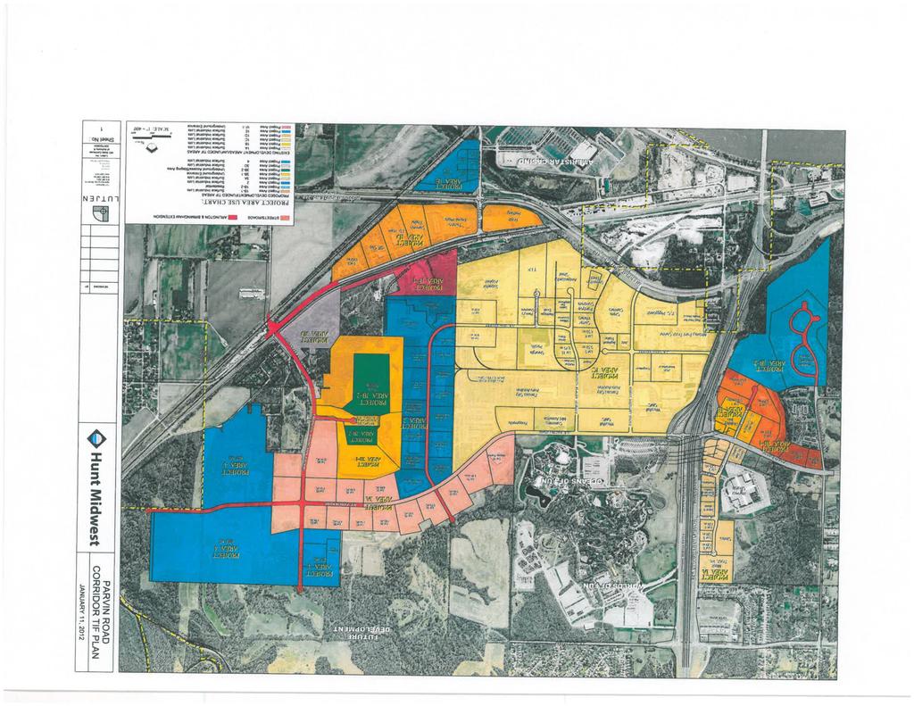
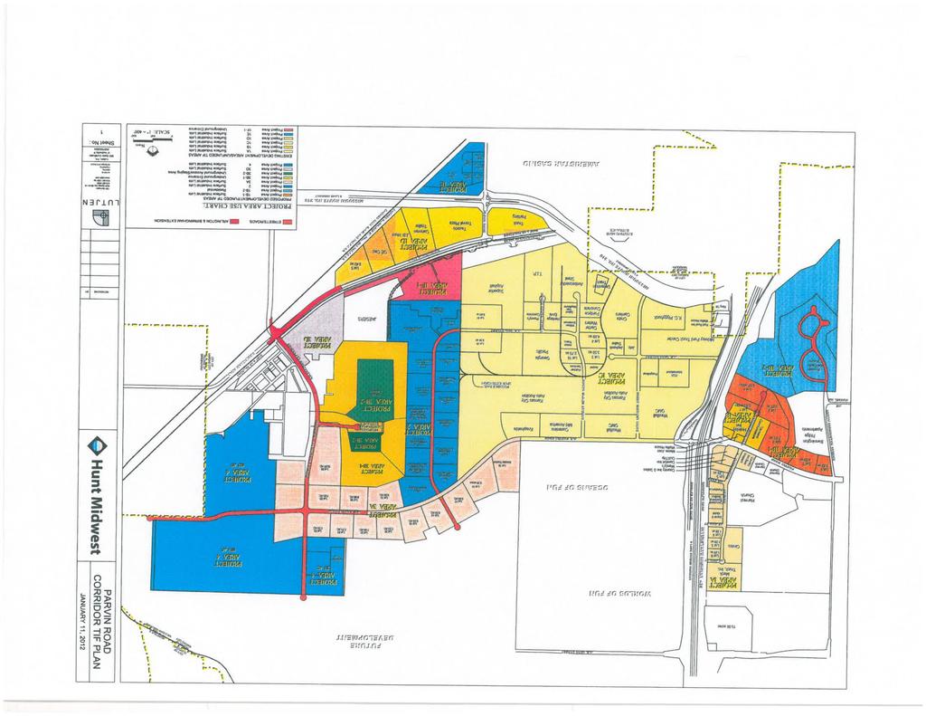
10 Amendment No. 6: Exhibit 2 {File: EDCKC/60/HUN/PARDCORR/540/ DOC /}{File: EDCKC/60/HUN/PARDCORR/540/ DOC
11
12
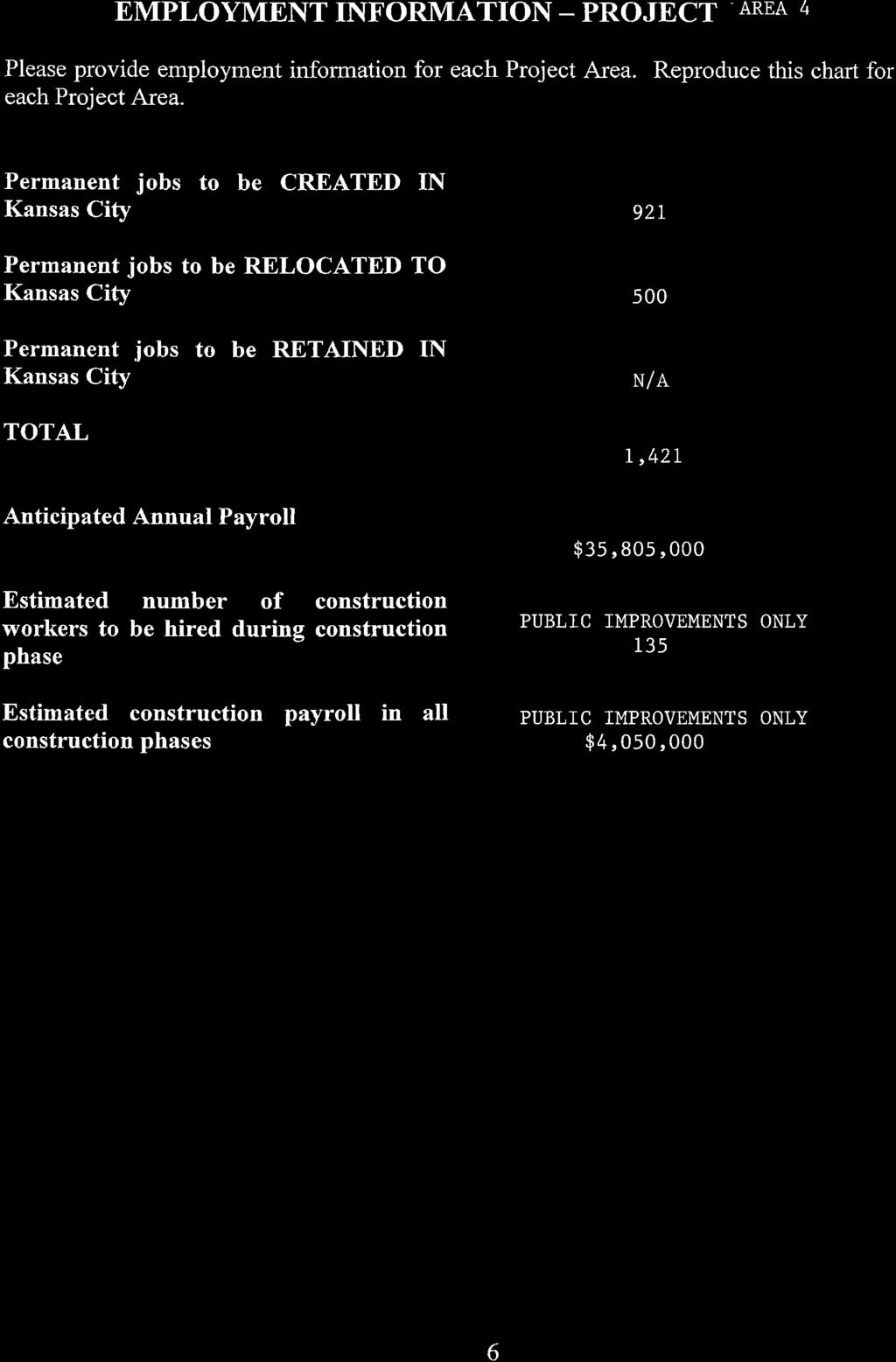
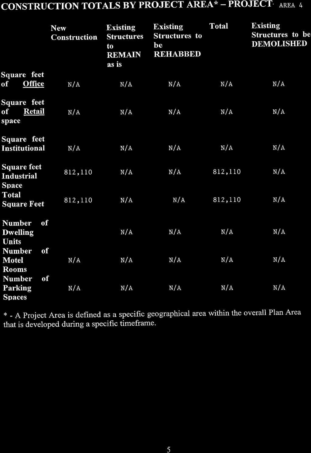
13 Amendment No. 8: Exhibit 4: Project Area 4 {File: EDCKC/60/HUN/PARDCORR/540/ DOC /}{File: EDCKC/60/HUN/PARDCORR/540/ DOC
14
15
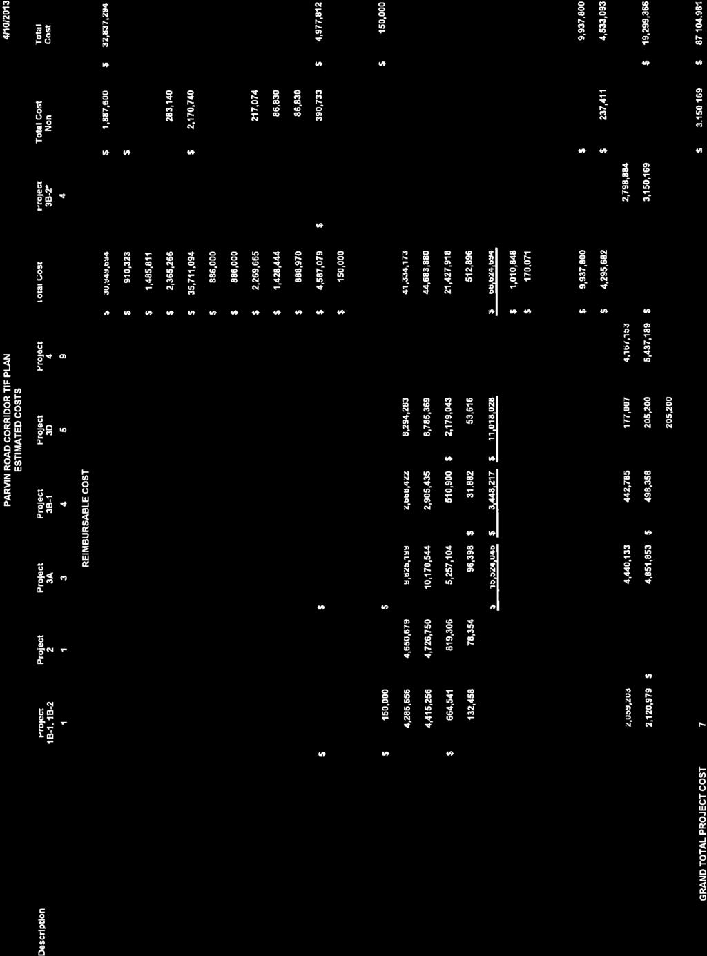
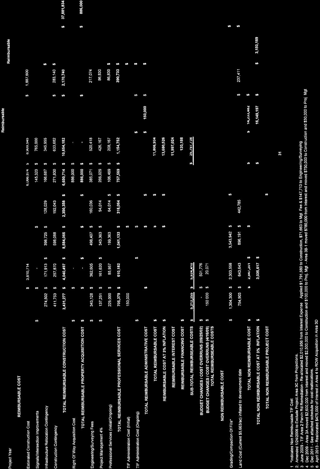
16 Amendment No. 9: Exhibit 5 Estimated Redevelopment Project Costs {File: EDCKC/60/HUN/PARDCORR/540/ DOC /}{File: EDCKC/60/HUN/PARDCORR/540/ DOC
17
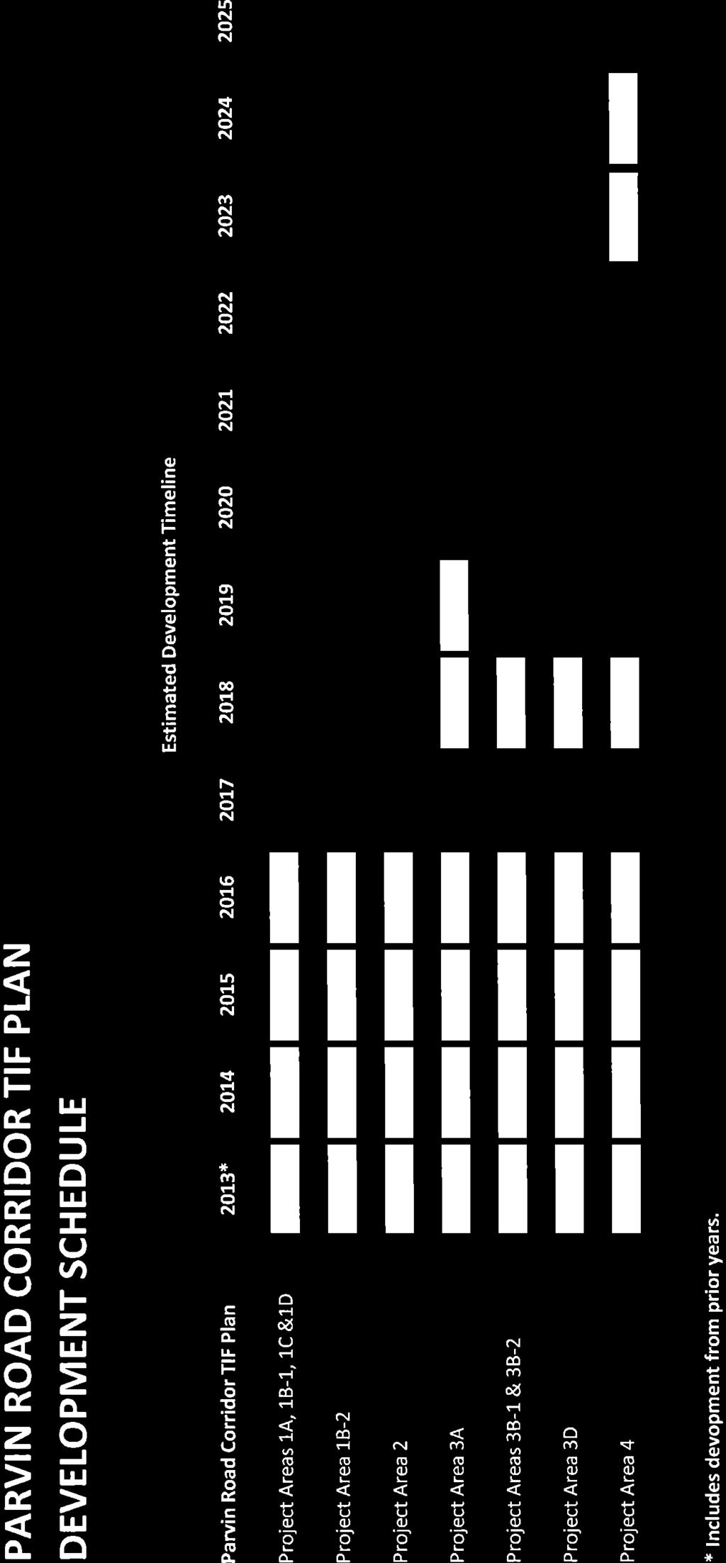
18 Amendment No. 10: Exhibit 6: Development Schedule {File: EDCKC/60/HUN/PARDCORR/540/ DOC /}{File: EDCKC/60/HUN/PARDCORR/540/ DOC
19
20 Amendment No. 11: Exhibit 12: Supplement to the Existing Conditions Study {File: EDCKC/60/HUN/PARDCORR/540/ DOC /}{File: EDCKC/60/HUN/PARDCORR/540/ DOC
21

22


23
24
25
26 Amendment No. 12: Exhibit 13: Acquisition & Disposition {File: EDCKC/60/HUN/PARDCORR/540/ DOC /}{File: EDCKC/60/HUN/PARDCORR/540/ DOC
27
28
29
30
31
32
33
34
35
36
RD:JVP:JMD File No. C /25/2016 ORDINANCE NO.
 ORDINANCE NO. AN ORDINANCE OF THE CITY OF SAN JOSE REZONING CERTAIN REAL PROPERTY OF APPROXIMATELY 8 ACRES, SITUATED ON THE NORTH SIDE OF PIERCY ROAD, APPROXIMATELY 450 FEET EAST OF HELLYER AVENUE (455
ORDINANCE NO by the Plan Commission
 First Federal Bank of Wisconsin Moorland & Greenfield MSO - 2012 ORDINANCE NO. 2286-12 by the Plan Commission ESTABLISH MSO-CS MODIFIED SUBURBAN OVERLAY DISTRICT CLUSTER SUBURBAN DEVELOPMENT PATTERN, DIMENSIONAL
VICINITY MAP SCALE 1'' = 2000'
 LOCATED IN THE SOUTHWEST QUARTER OF SECTION AND THE WEST HALF OF SECTION 4, TOWNSHIP SOUTH, RANGE 68 WEST OF THE 6TH PRINCIPAL MERIDIAN, SHEET OF 5 E47 TOLL ROAD CASE NO. ZAX 26-4 LEGAL DESCRIPTION: A
AGENDA Planning Review Committee Pinellas County Planning Department 310 Court Street, 1 st Floor Conference Room 119 April 8, :00 A.M.
 AGENDA Planning Review Committee Pinellas County Planning Department 310 Court Street, 1 st Floor Conference Room 119 April 8, 2013 10:00 A.M. Case Summary Review: 1. CU-3-1-13 Berati # 2, LLC 2. Z/LU/CU-7-3-13
Department of Land Conservation and Development 635 Capitol Street, Suite 150 Salem, OR Theodore R. Kulongoski, Governor (503)
") Oregon Department of Land Conservation and Development 635 Capitol Street, Suite 150 Salem, OR 97301-2540 Theodore R. Kulongoski, Governor (503) 373 0050 NOTICE OF ADOPTED AMENDMENT June 28, 2007 Fax (503)
Oregon Department of Land Conservation and Development 635 Capitol Street, Suite 150 Salem, OR 97301-2540 Theodore R. Kulongoski, Governor (503) 373 0050 NOTICE OF ADOPTED AMENDMENT June 28, 2007 Fax (503)
ORDINANCE NO. 954 AN ORDINANCE OF THE CITY OF SNOQUALMIE, WASHINGTON, ANNEXING CERTAIN CONTIGUOUS CITY-OWNED PROPERTY FOR MUNICIPAL PURPOSES
 ORDNANCE NO. 954 AN ORDNANCE OF THE CTY OF SNOQUALME, WASHNGTON, ANNEXNG CERTAN CONTGUOUS CTY-OWNED PROPERTY FOR MUNCPAL PURPOSES WHEREAS, the City has acquired certain real property legally described
NOTICE. INFRASTRUCTURE: Currently, the District is responsible for infrastructure in Lakewood Ranch COD 5 including but not limited to the following:
 This Instrument prepared by and recording return to: Lakewood Ranch Town Hall 8175 Lakewood Ranch Blvd. Lakewood Ranch, FL 34202 NOTICE DISCLOSURE OF PUBLIC FINANCING AND MAINTENANCE OF IMPROVEMENTS TO
DANE COUNTY ORDINANCE AMENDMENT NO: Internal Tracking Number: RECU25846
 DANE COUNTY ORDINANCE AMENDMENT NO: 10314 Internal Tracking Number: RECU25846 Amending Section 10.03 relating to Zoning Districts in the Town of Cottage Grove. The Dane County Board of Supervisors does
BEFORE THE BOARD OF SUPERVISORS OF THE COUNTY OF MADERA STATE OF CALIFORNIA. ) Resolution No.: ) ) A RESOLUTION VACATING
 Resolution No.: ) ) A RESOLUTION VACATING") BEFORE THE BOARD OF SUPERVISORS OF THE COUNTY OF MADERA STATE OF CALIFORNIA In the Matter of RESOURCE MANAGEMENT AGENCY - ROAD DEPARTMENT ) Resolution No.: 2012 - ) ) A RESOLUTION VACATING ) BLACKHAWK
BEFORE THE BOARD OF SUPERVISORS OF THE COUNTY OF MADERA STATE OF CALIFORNIA In the Matter of RESOURCE MANAGEMENT AGENCY - ROAD DEPARTMENT ) Resolution No.: 2012 - ) ) A RESOLUTION VACATING ) BLACKHAWK
THE PEOPLE OF THE CITY OF LOS ANGELES DO ORDAIN AS FOLLOWS:
 ORDNANCE NO. 8544 An ordinance replacing Ordinance No. 8063, which dedicated, accepted and established certain real property owned by the City of Los Angeles, lying west of Longacre Avenue and Zeizah Avenue,
LEE COUNTY BOARD OF COUNTY COMMISSIONERS AGENDA ITEM SUMMARY BLUE SHEET NO:
 1. REQUESTED MOTION: LEE COUNTY BOARD OF COUNTY COMMISSIONERS AGENDA ITEM SUMMARY BLUE SHEET NO: 20021093 ACTION REQUESTED: Ado t a Resolution to Vacate a portion of Harbour Landing Drive Right-of-Way
MEMORANDUM OF AGREEMENT
 1 2 3 4 AMENDMENT NO. 4 5 TO THE 6 MEMORANDUM OF AGREEMENT 7 BETWEEN 8 THE UNITED STATES OF AMERICA 9 ACTING BY AND THROUGH 10 THE SECRETARY OF THE ARMY 11 UNITED STATES DEPARTMENT OF THE ARMY 12 AND THE
Village of Menomonee Falls Wisconsin. Project Plan. December 23, 2009
 Village of Menomonee Falls Wisconsin Tax Incremental District No. 9 Project Plan December 23, 2009 Prepared by The Village of Menomonee Falls, Wisconsin Redevelopment Manager Von Briesen & Roper, S.C.
b. City of Dunedin Notices of Public Hearings regarding proposed Ordinance No to be held August 1, 2013, annexing two parcels of property.
 AGENDA ITEM# 12 July 9, 2013 12. MISCELLANEOUS ITEMS TO BE RECEIVED FOR FILING: a. City of Clearwater Notice of Amendment to the Clearwater Community Development Code regarding proposed Ordinance No. 8431-13;
INTERLOCAL AGREEMENT AMONG FLAGLER COUNTY, FLORIDA; THE CITY OF PALM COAST, FLORIDA; AND THE FLORIDA AGRICULTURAL MUSEUM, INC.
 INTERLOCAL AGREEMENT AMONG FLAGLER COUNTY, FLORIDA; THE CITY OF PALM COAST, FLORIDA; AND THE FLORIDA AGRICULTURAL MUSEUM, INC. RELATING TO THE FUTURE GROWTH AND DEVELOPMENT OF THE MUSEUM THIS INTERLOCAL
P.L. 1999, CHAPTER 258, approved October 15, 1999 Assembly, No (First Reprint)
") P.L., CHAPTER, approved October, Assembly, No. 0 (First Reprint) 0 0 0 AN ACT concerning the approval and filing of maps and amending P.L.0, c.. BE IT ENACTED by the Senate and General Assembly of the
P.L., CHAPTER, approved October, Assembly, No. 0 (First Reprint) 0 0 0 AN ACT concerning the approval and filing of maps and amending P.L.0, c.. BE IT ENACTED by the Senate and General Assembly of the
RELEASE OF JOINT FORM DEED OF CONSERVATION EASEMENT AND AGREEMENT
 Prepared by: Michael C. Owens, Sr. Ass't. County Attorney Broward County Off. of the County Attorney 115 S. Andrews Avenue, Room 423 Fort Lauderdale, FL 33301 Exhibit 4 Page 1 of 5 Return original or certified
Item 2. September 28, 2017
 September 28, 2017 Item 2 Applicant: Georgetown Development Location: 190 N 1100 W Prepared by: Sean Conroy, Community Development Director Public Hearing: No Zone: PRD-1 Attachments: 1. Findings. 2. Project
BEFORE THE BOARD OF COUNTY COMMISSIONERS OF DESCHUTES COUNTY, OREGON * * * *
 REVIEWED LEGAL COUNSEL For Recording Stamp Only BEFORE THE BOARD OF COUNTY COMMISSIONERS OF DESCHUTES COUNTY, OREGON An Ordinance Amending Deschutes County Code Title 18 to Provide a Definition of Agricultural
Site Plan/Building Permit Review
 Part 6 Site Plan/Building Permit Review 1.6.01 When Site Plan Review Applies 1.6.02 Optional Pre- Application Site Plan/Building Permit Review (hereafter referred to as Site Plan Review) shall be required
Example Plans: Business Signs (Not For Construction)
") Plans: Business s Site Plan 220 10 utility easement 120 40 50 Proposed Awning Proposed Freestanding 40 79 20 Street Name Proposed Wall C L N 123 Historic Way Indianapolis, IN 46000 Basic Elements of a
Plans: Business s Site Plan 220 10 utility easement 120 40 50 Proposed Awning Proposed Freestanding 40 79 20 Street Name Proposed Wall C L N 123 Historic Way Indianapolis, IN 46000 Basic Elements of a
CITY OF OLIVETTE SITE PLAN AND COMMUNITY DESIGN REVIEW INFORMATION PACKET
 CITY OF OLIVETTE SITE PLAN AND COMMUNITY DESIGN REVIEW INFORMATION PACKET THE FOLLOWING PACKET CONTAINS: PETITION FOR NONRESIDENTIAL DEVELOPMENT SITE PLAN AND COMMUNITY DESIGN REVIEW SCHEDULE OF DATES
APPLICATION FOR PLANNED UNIT DEVELOPMENT (PUD) DEVELOPMENT PLAN
 DEVELOPMENT PLAN") 209 S. Main Street Marysville, Ohio 43040 Phone: (937) 645-7350 Fax: (937) 645-7351 www.marysvilleohio.org APPLICATION FOR PLANNED UNIT DEVELOPMENT (PUD) DEVELOPMENT PLAN *** IMPORTANT INFORMATION ~ Please
209 S. Main Street Marysville, Ohio 43040 Phone: (937) 645-7350 Fax: (937) 645-7351 www.marysvilleohio.org APPLICATION FOR PLANNED UNIT DEVELOPMENT (PUD) DEVELOPMENT PLAN *** IMPORTANT INFORMATION ~ Please
Procedure to Petition for Plat Review and Site Plan Review
 Economic Development Department (734) 676-7104 or (734) 676-7109 Procedure to Petition for Plat Review and Site Plan Review All site plans shall be submitted to the Economic Development Department to be
CHAPTER 3. Public Schools Facility Element
 CHAPTER 3 Public Schools Facility Element Page 1 of 12 CHAPTER 3 PUBLIC SCHOOL FACILITIES ELEMENT GOAL 3.1: Collaborate and coordinate with the School Board of Volusia County to provide and maintain a
Recommended Changes to the Public Hearing Draft Zoning Ordinance
 DATE: December 6, 2016 TO: Village of Oak Park FROM: Arista Strungys SUBJECT: Recommended Changes Recommended Changes to the Public Hearing Draft Zoning Ordinance ZONING MAP» Edit to remove right-of-way
1. Call to Order: Chairman Garcia called the meeting to order at 7:41 p.m.
 MINUTES CITY OF HIALEAH GARDENS TUESDAY, AUGUST 16, 2005 CITY COUNCIL CHAMBERS 10001 NW 87 AVENUE 1. Call to Order: Chairman Garcia called the meeting to order at 7:41 p.m. 2. Roll Call: Present were Chairman
Exhibit A. Property Description for Tract SAC
 Exhibit A May, 217 Tract 5AC Pagel of 4 County: Highway: Limits: RCSJ: Harris S.H. 99 (Grand Parkway) Morton Ranch Road to Clay Road 351-5-38 Property Description for Tract SAC Being an "Access Line" delineating
Hillside & Foothills Development Application
 Hillside & Foothills Development Application This box for office use only File #: Cross Referenced File(s): Fee: Zone(s): Are Pre-Application materials attached? Yes No This application is a request to
Legal Description & Site Plan Requirements and Layouts
 Legal Description & Site Plan Requirements and Layouts Plot Plan * A plot plan shows the location of a house from an aerial view. * The site plan, also known as a plot or lot plan includes: 1. Site plan
FLORIDA STATUTES Volume 1 TITLE I
 FLORIDA STATUTES 1987 Volume 1 TITLE I CONSTRUCTION OF STATUTES CHAPTER 1 DEFINITIONS 1.01 Definitions. 1.02 Legal time. 1.04 Statutory construction ; amendatory acts passed at the same session. 1.01 Definitions.-ln
Annual Report For the Fiscal Year Ending June 30, 2017
 - Annual Report For the Fiscal Year Ending June 30, 2017 Western Municipal Water District Series 2011 Special Tax Bonds Community Facilities District No. 88-1 Prepared for: December 2017 Table of Contents
ORDINANCE NO / 0 If
 ORDINANCE NO. 2017- / 0 If AN ORDINANCE OF THE CITY OF TAMPA, FLORIDA, ESTABLISHING THE K-BAR RANCH II COMMUNITY DEVELOPMENT DISTRICT (GENERALLY LOCATED SOUTH OF THE PASCO COUNTY LINE, EAST OF KINNAN STREET,
CHAPTER 11 PRELIMINARY SITE PLAN APPROVAL PROCESS
 CHAPTER 11 PRELIMINARY SITE PLAN APPROVAL PROCESS 11.01.00 Preliminary Site Plan Approval 11.01.01 Intent and Purpose 11.01.02 Review 11.01.03 Application 11.01.04 Development Site to be Unified 11.01.05
Pinellas County. Staff Report
 Pinellas County 315 Court Street, 5th Floor Assembly Room Clearwater, Florida 33756 Staff Report File #: 15-523, Version: 1 Agenda Date: 11/24/2015 Subject: Case No. Q Z-26-10-15 (GGR Ozona, LLP) A request
ORDINANCE NO SECTION 1. LEGAL DESCRIPTIONS.
 ORDINANCE NO. 1095 AN ORDINANCE OF THE CITY OF OKEECHOBEE, FLORIDA; AMENDING THE OFFICIAL ZONING MAP OF OKEECHOBEE, BY REZONING CERTAIN TRACTS OF LAND MORE PARTICULARLY DESCRIBED HEREIN, FROM HOLDING TO
LCRA TRANSMISSION SERVICES CORPORATION
 UCRA ENEtGY WATER COMMUNfnf SEEVICES LCRA TRANSMISSION SERVICES CORPORATION April 28, 2016 «FirstName» «LastName» «Suffix» «SecondName» «Address1» «Address2» «Address3» «City», «State» «Zip» RE: Application
Conceptual, Preliminary and Final Site Plan Review in Holladay City
 Conceptual, Preliminary and Final Site Plan Review in Holladay City The City of Holladay incorporated in December, 1999 and adopted its own zoning ordinance in May, 2000. All land use decisions are made
Charlotte-Mecklenburg Planning Department Review Fees
 Charlotte-Mecklenburg Planning Department Review Fees (Rezoning / Subdivision / Zoning Administration) (July 1, 2010 June 30, 2011) FEES EFFECTIVE JULY 1, 2010 REZONING APPLICATION, CONDITIONAL ZONING
SOUTH COLLEGE STREET EAST STONEWALL STREET OFFICE BUILDING PARKING DECK N02 N03 N01 PETITION # B73340
 N02 SOUTH COLLEGE STREET N03 EAST STONEWALL STREET 277 WAY # HIGH WAY STATE INTER BELK FREE JOHN OFFICE BUILDING PARKING DECK N01 PETITION # 2017-087 DWG BY RJW DATE 04/02/17 1 DATE REVISION 4.18.17 05.04.17
B.2 MAJOR SUBDIVISION PRELIMINARY PLAN CHECKLIST
 B.2 MAJOR SUBDIVISION PRELIMINARY PLAN CHECKLIST YES* GENERAL SUBMISSION ITEMS Does the submission include: 1. Thirteen (13) copies of completed Application Form? 2. Thirteen (13) copies of the Preliminary
A Bill Regular Session, 2017 HOUSE BILL 1926
 Stricken language would be deleted from and underlined language would be added to present law. 0 0 0 State of Arkansas st General Assembly As Engrossed: H// A Bill Regular Session, 0 HOUSE BILL By: Representative
N02 N03 OFFICE BUILDING PARKING DECK B73340 SHEET
 SIGN INVENTORY SITE: SIGN PAGE PROPOSED SIGN 2 RFC.REG-IL78MWL-RW 3 RFC.REG-IL78MWL-RW 4 RFC.REG-IL24MWL OFFICE BUILDING PARKING DECK DWG BY RJW DATE 04/02/17 1 DATE 4.4.17 4.5.17 4.14.17 4.18.17 05.04.17
(Protectorate) Registration Ordinance; it shall apply to the Protectorate.
 Registration Ordinance; it shall apply to the Protectorate.") 1058 Cap. 93] Births and Deaths (Protectorate) Registration CHAPTER 93. SECTION. BIRTHS AND DEATHS (PROTECTORATE) REGISTRATION. ARRANGEMENT OF SECTIONS. 1. Short title and application. 2. Interpretation.
1058 Cap. 93] Births and Deaths (Protectorate) Registration CHAPTER 93. SECTION. BIRTHS AND DEATHS (PROTECTORATE) REGISTRATION. ARRANGEMENT OF SECTIONS. 1. Short title and application. 2. Interpretation.
CHECKLIST PRELIMINARY SUBDIVISION AND PRELIMINARY SITE PLAN
 N/A Waiver (1) Four (4) copies of application form. (2) Fifteen (15) copies of plan (3) Subdivision/site plan application fee & professional review escrow deposit (4) Variance application fee & professional
PRELIMINARY PLAT CHECK LIST
 Name of Proposed Subdivision: The following items must be included with the initial submittal of a Preliminary Plat: Application, filled out completely Project Narrative Pre-application Conference Report
BEFORE THE STATE OIL AND GAS BOARD OF MISSISSIPPI
 » & BEFORE THE STATE OIL AND GAS BOARD OF MISSISSIPPI RE: FILED FOR RECORD PETITION OF DENBURY ONSHORE, LLC TO AMEND THE SPECIAL FIELD RULES FOR THE WEST LITTLE CREEK FIELD, PIKE AND JUN 1 5 2005 LINCOLN
SPECIFICATIONS FOR THE INSTALLATION OF CONDUIT SYSTEMS IN RESIDENTIAL SUBDIVISIONS. Notification of Completed Conduit Sections
 SPECIFICATIONS FOR THE INSTALLATION OF CONDUIT SYSTEMS IN RESIDENTIAL SUBDIVISIONS Section 1 Definitions 2 Scope of Work 3 Extent of Work 4 Inspection and Performance of Work 5 Trenching 6 Duct Installation
SAN DIEGO CITY SCHOOLS
 S C D S SAN DIEGO CITY SCHOOLS EUGENE BRUCKER EDUCATION CENTER 4100 Normal Street, San Diego, CA 92103-2682 Executive Summary Board Date: November 13, 2001 Office of the Superintendent SUBJECT: Resolution
6.05 acres acres Single-family attached
 R E S O L U T I O N WHEREAS, the Prince George's County Planning Board is charged with the approval of Detailed Site Plans pursuant to Part 3, Division 9 of the Zoning Ordinance of the Prince George's
Alabama Standards of Practice for Surveying
 PDHonline Course L144 (6 PDH) Alabama Standards of Practice for Surveying Instructor: Jerry Thacker, PLS, P.E. and John C. Huang, Ph.D., P.E. 2012 PDH Online PDH Center 5272 Meadow Estates Drive Fairfax,
PLANNING AND DEVELOPMENT
 OVERVIEW Effective January 1, 1992 all applications for multi-family residential and all non-residential building permits require site plan approval before permit issuance. All new developments and existing
j -5- ~n~ Kay ~--'; l: L: ps, ~,; e:;: appearing by fully and sufficiently advised in the premises, enters these findings application for FIB
 DATE Oi: M\! U:< G j. j -5- ~n~ DISTRICT COURT, WATER DIVISION NO. 4, STATE OF COLORADO FUed fn Th~ 2i: trict Court i,=: ic:. C.'~,~~.; FIB 5 1986 n f~ji.;r Case No. 83 CW 45 jj [) (l' J Kay ~--'; l: L:
7000 Fifteen Mile Road Sterling Heights, Michigan
 7000 Fifteen Mile Road Sterling Heights, Michigan Industrial Building With Excess Land and Rail Access As exclusive agents, we are pleased to offer the following property for lease: 128,648 Sq. Ft. Completely
Fundamentals III CHAPTER PROJECT EXERCISE
 CHAPTER 4 Fundamentals III PROJECT EXERCISE This project exercise provides point-by-point instructions for setting up the drawing with layers and then creating the objects shown in Figure P4 1. FIGURE
CITY OF SACRAMENTO SACRAMENTO COUNTY, CALIFORNIA
 CITY OF SACRAMENTO SACRAMENTO COUNTY, CALIFORNIA ENGINEER'S REPORT FOR THE LAND-CURTIS PARK STREET LIGHTING ASSESSMENT DISTRICT NO. 2007-04 As Accepted By The City of Sacramento November 2007 ENGINEER
Planning Permit Application LAND USE PRELIMINARY APPLICATION (LUP)
") Planning Permit Application LAND USE PRELIMINARY APPLICATION (LUP) 415 W 6 th ST ~ Vancouver, WA 98660 PO Box 1995 ~ Vancouver, WA 98668 Phone (360) 487-7800 www.cityofvancouver.us Type Of Work Type I
Planning Permit Application LAND USE PRELIMINARY APPLICATION (LUP) 415 W 6 th ST ~ Vancouver, WA 98660 PO Box 1995 ~ Vancouver, WA 98668 Phone (360) 487-7800 www.cityofvancouver.us Type Of Work Type I
CHAPTER ONE: ORGANIZATION, FUNCTIONS, AND GENERAL PROVISIONS. Subchapter 1.01: General
 CHAPTER ONE: ORGANIZATION, FUNCTIONS, AND GENERAL PROVISIONS 1.01.010 Title Subchapter 1.01: This code of ordinances of the Town of Colma shall be known as the Town of Colma Municipal Code. [History: formerly
Update: July 20, 2012
 Location and Design Manual, Volume 3 ODOT Office of CADD and Mapping Services Update: July 20, 2012 ** NOTE: All metric references have been removed from this manual. ** PREFACE REVISIONS Glossary of Terms
Moline Illinois CODE OF ORDINANCES. Art. IX. Miscellaneous DIVISION 3. IN-BUILDING EMERGENCY RADIO SYSTEM COVERAGE
 Moline Illinois CODE OF ORDINANCES Art. IX. Miscellaneous DIVISION 3. IN-BUILDING EMERGENCY RADIO SYSTEM COVERAGE SEC. 8-9300. TITLE. The title of this division shall be the Emergency Radio System Coverage
WGA LOW BUDGET AGREEMENT--APPLICATION
 WGA LOW BUDGET AGREEMENT--APPLICATION ( Company ) has read the Writers Guild of America ( WGA ) Low Budget Agreement (the Low Budget Agreement ). Company desires to produce (the Picture ) under the Low
LUCAS MUNOZ SURVEY NO. 86 ABSTRACT NO. 488, N.C.B CITY OF SAN ANTONIO, BEXAR, TEXAS.
 PALM VALLEY LOCATION MAP PARADISE TRACE SOL HALLIE PL VALLEY RD R.O.W. SQ.FT. D.R. FIR SIR G,E,T,CA D.P.R. O.P.R. N.T.S. 410 RAY ELLISON BLVD LEGEND SET 1/2" IRON ROD W/ CAP STAMPED "VICKREY PROP. COR."
Locate Request Information
 Locate Request Information NOTE: DO NOT USE any apostrophes ( )or quotation marks ( ) in Web Ticket Entry. Doing so may hamper the transmission of tickets to the utilities and locators. Limit per Ticket
Site Plan Review Application. Interest in the Property (e.g. fee simple, land option, etc.)
") 1. Identification CITY OF FENTON 301 South Leroy Street Fenton, Michigan 48430-2196 (810) 629-2261 FAX (810) 629-2004 Site Plan Review Application Project Name Applicant Name Address City/State/Zip Phone
1. Identification CITY OF FENTON 301 South Leroy Street Fenton, Michigan 48430-2196 (810) 629-2261 FAX (810) 629-2004 Site Plan Review Application Project Name Applicant Name Address City/State/Zip Phone
California State University, Northridge Policy Statement on Inventions and Patents
 Approved by Research and Grants Committee April 20, 2001 Recommended for Adoption by Faculty Senate Executive Committee May 17, 2001 Revised to incorporate friendly amendments from Faculty Senate, September
KEY MAP PLAN AREA MAP. St. Albans Sub-Area Plan. Area Boundary
 Richmond Official Community Plan CITY CENTRE AREA ST. ALBANS SUB-AREA PLAN Bylaw 7100 Schedule 2.10A ST. ALBANS SUB-AREA PLAN z ST. ALBANS SUB-AREA PLAN z ST. ALBANS SUB-AREA PLAN KEY MAP PLAN AREA MAP
WHITNEY OAKS (MAP SHEET 3)
") WHITNEY OAKS (MAP SHEET 3) Owner: Cal-Stanford Oaks L.L.C. 9404 Genesee Avenue, Suite 230 La Jolla, CA 92037 Live Oak Enterprises, Inc. Phone: (916) 782-1177 C/o Peter Bridges File #: Area: Northeastern
WHITNEY OAKS (MAP SHEET 3) Owner: Cal-Stanford Oaks L.L.C. 9404 Genesee Avenue, Suite 230 La Jolla, CA 92037 Live Oak Enterprises, Inc. Phone: (916) 782-1177 C/o Peter Bridges File #: Area: Northeastern
Applying for a Site Development Review
 Guide What is it? Applying for a Who approves it? ensures that new buildings or land uses are compatible with their sites and with the surrounding environment, other development, and traffic circulation.
CITY OF LOMPOC DEVELOPMENT ASSISTANCE BROCHURE ENCROACHMENT PERMITS AND PUBLIC IMPROVEMENT PLANS
 CITY OF LOMPOC DEVELOPMENT ASSISTANCE BROCHURE E-10 ENCROACHMENT PERMITS AND PUBLIC IMPROVEMENT PLANS The City of Lompoc has determined that the Engineering Division should administer and issue Encroachment
Maintenance of Traffic sequence of operations including any phasing and detour maps;
 All Local-let projects are required to have a Stage 2 submittal to the LPA Manager for review. The only exceptions are 2-lane resurfacing, striping, guardrail, and raised pavement markers, unless otherwise
Wisconsin Corner Point Identification System January 2006
 Wisconsin Corner Point Identification System January 2006 The Wisconsin Point Identification system was developed by a special committee chaired by Mike Romportl, Oneida County Surveyor in the early 1990
Costa Mesa California
 Costa Mesa California Section 1. Title 5 of the Costa Mesa Municipal Code entitled Building and Structures, is hereby amended to add Chapter IX, entitled INBUILDING PUBLIC SAFETY RADIO SYSTEM COVERAGE
Technology transactions and outsourcing deals: a practitioner s perspective. Michel Jaccard
 Technology transactions and outsourcing deals: a practitioner s perspective Michel Jaccard Overview Introduction : IT transactions specifics and outsourcing deals Typical content of an IT outsourcing agreement
Applying for a Site Development Review (Sign CVCBD only)
") Guide Applying for a Site Development Review (Sign CVCBD only) What is it? Site Development Review ensures that new buildings or land uses are compatible with their sites and with the surrounding environment,
Guide Applying for a Site Development Review (Sign CVCBD only) What is it? Site Development Review ensures that new buildings or land uses are compatible with their sites and with the surrounding environment,
SURVEYOR S REPORT VERTICAL CONTROL FOR CONSTRUCTION C-44 PROJECT
 Post Office Box 1469 Palm City, FL 34991 Martin: 772.286.8083 Fax: 772.283.6174 Statewide: 800.386.1066 www.gcyinc.com SURVEYOR S REPORT VERTICAL CONTROL FOR CONSTRUCTION C-44 PROJECT The purpose of this
General Requirements for the Preparation of Plans
 August 6, 2003 General Requirements for the Preparation of Plans NOTE: This document is a Controller of Surveys Policy manual to be used as a general guideline for the preparation and examination of plans.
View referenced exhibit back-up material. (See Report to the City Council No ) Adoption of a Resolution certifying findings that:
 Adoption of a Resolution certifying findings that:") Page 9 ITEM-S701: Hillel of San Diego Student Center, Project No. 149437. An application for a Public Right-of-Way Vacation (portion of La Jolla Scenic Drive North between Torrey Pines Road and La Jolla
Page 9 ITEM-S701: Hillel of San Diego Student Center, Project No. 149437. An application for a Public Right-of-Way Vacation (portion of La Jolla Scenic Drive North between Torrey Pines Road and La Jolla
King Mill Lambert DRI# 2035 Henry County, Georgia
 Transportation Analysis King Mill Lambert DRI# 2035 Henry County, Georgia Prepared for: The Alter Group, Ltd. Prepared by: Kimley-Horn and Associates, Inc. Norcross, GA Kimley-Horn and Associates, Inc.
MULTIPLE-FAMILY DESIGN REVIEW SUBMITTAL CHECKLIST
 MULTIPLE-FAMILY DESIGN REVIEW SUBMITTAL CHECKLIST This application lists the content and format of the submittal requirements to initiate the Design Review process. An incomplete application will not be
SECTION 3. Housing. FAppendix F SLOPE DENSITY
 SECTION 3 Housing FAppendix F SLOPE DENSITY C-2 Housing Commission Attachment B Appendix F Slope Density STATEMENT OF PURPOSE This appendix has been prepared with the intent of acquainting the general
created by: The Curriculum Corner
 created by: The Curriculum Corner I can understand fractions. I can show and understand that fractions represent equal parts of a whole, where the top number is the part and the bottom number is the total
Lantz-Boggio Architects 5650 DTC Parkway, Suite 220 Englewood, CO UPPER LEVEL 113' - 4"
 CASTLE PINES NORTH FILING NO. 9. LOTS,,,, TRACT B AND TRACT J A PORTION OF THE N / OF SECTION, TS, RW, SIXTH P.M.. ACRES XXXX-XXX ' - " 00 00 0 KEYNOTE LEGEND 00 00 0 0 0 0 00 0 ' - " ' - " ' - " 00' -
Washington County Road Engineering Plan Submittal/Review Checklist
 Washington County Road Engineering Plan Submittal/Review Checklist Washington County Land Use Case File Number: Parcel(s): Developer/Owner Name(s): Developer/Owner E-mail(s): The following elements should
1I III III VII IIIII IIV
 3453310 03/23/ 2012 02:33 43 PM Pages. 2 Vacation COWLITZ COUNTY PUBLIC WORKS 63.00 Cowlitz County Washington 1I111111111111III11111111111111111 III VII IIIII IIV 11111113113 13 BEFORE THE BOARD OF COUNTY
Board of County Commissioners of Lincoln County Agenda for November 26, 2013
 Board of County Commissioners of Lincoln County Agenda for November 26, 2013 9:00 Call to order and Pledge of Allegiance 9:00 Emergency Manager John DeWitt to request that the Commissioners sign the county
TOWN OF MANCHESTER PLANNING AND ZONING COMMISSION. 7:00 P.M. 494 Main Street AGENDA
 TOWN OF MANCHESTER PLANNING AND ZONING COMMISSION September 18, 2017 Lincoln Center Hearing Room 7:00 P.M. 494 Main Street AGENDA PUBLIC HEARING: 1. TOWN OF MANCHESTER PLANNING & ZONING COMMISSION To revise
SUBMITTAL REQUIREMENTS RCV D REJECT PENDING
 1 of 5 SUBMITTAL REQUIREMENTS RCV D REJECT PENDING 1. General Information. 1.1 Applicant s name, address and contact numbers. 1.2 Project name, type, address and legal description of the property. 1.3
Oakland County Michigan Register of Deeds Plat Engineering, GIS, & Remonumentation Dept. Ph: (248) Fax (248)
 Fax (248)") Oakland County Michigan Register of Deeds Plat Engineering, GIS, & Remonumentation Dept. Ph: (248)-858-1447 Fax (248)-858-7466 Requirements Needed for Final Condominium Approval General Requirements. 1
Oakland County Michigan Register of Deeds Plat Engineering, GIS, & Remonumentation Dept. Ph: (248)-858-1447 Fax (248)-858-7466 Requirements Needed for Final Condominium Approval General Requirements. 1
FRENCHTOWN CHARTER TOWNSHIP PLANNING COMMISSION OFFICE (734) EXT. 4 FAX (734)
 EXT. 4 FAX (734)") FRENCHTOWN CHARTER TOWNSHIP PLANNING COMMISSION OFFICE (734) 242-5900 EXT. 4 FAX (734) 242-1634 PARCEL I.D.# DATE APPLICANT ADDRESS CITY STATE ZIP CODE TELEPHONE ( ) FAX ( ) OWNER ADDRESS CITY STATE ZIP
FRENCHTOWN CHARTER TOWNSHIP PLANNING COMMISSION OFFICE (734) 242-5900 EXT. 4 FAX (734) 242-1634 PARCEL I.D.# DATE APPLICANT ADDRESS CITY STATE ZIP CODE TELEPHONE ( ) FAX ( ) OWNER ADDRESS CITY STATE ZIP
Scope of Services. Project management tasks are estimated based upon anticipated project duration of 52 weeks.
 Scope of Services Project Understanding The City of Sparks (City) has also requested the HDR Engineering, Inc. (HDR) provided limited shop drawing review and periodic observation during construction and
appendix f: slope density
 CONTENTS: F-2 Statement of Purpose F-3 Discussion of Slope F-4 Description of Slope Density The Foothill Modified Slope Density The Foothill Modified 1/2 Acre slope density The 5 20 slope density F-7 How
CLEAN ENERGY FUELS CORP. Filed by PICKENS BOONE
 CLEAN ENERGY FUELS CORP. Filed by PICKENS BOONE FORM SC 13D/A (Amended Statement of Beneficial Ownership) Filed 09/06/11 Address 3020 OLD RANCH PARKWAY, SUITE 400 SEAL BEACH, CA 90740 Telephone (562) 493-2804
CITY OF APACHE JUNCTION DEVELOPMENT SERVICES CIVIL ENGINEERING PLAN REVIEW CHECKLIST PROJECT: LOCATION:
 CITY OF APACHE JUNCTION DEVELOPMENT SERVICES CIVIL ENGINEERING PLAN REVIEW CHECKLIST PROJECT: LOCATION: LOG NO.: LEGEND REVIEW REVIEWED BY DATE / - Requirement satisfied 1 O Requirement not satisfied 2?
DOCUMENT MINIMUM CONSTRUCTION DRAWING REQUIREMENTS FOR PRELIMINARY REVIEW/APPROVAL 1.2. GALVESTON COUNTY CONSOLIDATED DRAINAGE DISTRICT (GCCDD)
") DOCUMENT 01105 FOR PRELIMINARY REVIEW/APPROVAL PART I: SUBMITTAL 1.1 CITY OF FRIENDSWOOD (COF) A. Submit four (4) copies of drawings. B. Submit by 5:00 PM a minimum of fourteen calendar days (14 cd) prior
DOCUMENT 01105 FOR PRELIMINARY REVIEW/APPROVAL PART I: SUBMITTAL 1.1 CITY OF FRIENDSWOOD (COF) A. Submit four (4) copies of drawings. B. Submit by 5:00 PM a minimum of fourteen calendar days (14 cd) prior
MATHEMATICS OF GRAPHING AND SURVEYING CHAPTER 9 INTRODUCTION TO GRAPHING AND SURVEYING
 CHAPTER 9 MATHEMATICS OF GRAPHING AND SURVEYING INTRODUCTION TO GRAPHING AND SURVEYING Real estate typically refers to a physical asset that is tied to one geographic location. Because it is durable (lasts
COUNTY COUNCIL OF PRINCE GEORGE S COUNTY, MARYLAND SITTING AS THE DISTRICT COUNCIL ORDER OF REMAND
 Case No.: Applicants: DSP-11017 Hyattsville Subway Sandwich Shop (Amendment of Conditions) Punam Singh/ Jagjot Singh Khandpur, Esq. COUNTY COUNCIL OF PRINCE GEORGE S COUNTY, MARYLAND SITTING AS THE DISTRICT
WHEREAS, the City of (the City ) is an Illinois municipality in. accordance with the Constitution of the State of Illinois of 1970; and,
 is an Illinois municipality in. accordance with the Constitution of the State of Illinois of 1970; and,") SMALL CELL ANTENNA/TOWER RIGHT-OF-WAY SITING ORDINANCE WHEREAS, the City of (the City ) is an Illinois municipality in accordance with the Constitution of the State of Illinois of 1970; and, WHEREAS, the
SMALL CELL ANTENNA/TOWER RIGHT-OF-WAY SITING ORDINANCE WHEREAS, the City of (the City ) is an Illinois municipality in accordance with the Constitution of the State of Illinois of 1970; and, WHEREAS, the
O R D I N A N C E NO AN ORDINANCE, establishing building lines or floodway. reservation lines along and adjacent to Black Creek and its
 O R D I N A N C E NO. 2212 AN ORDINANCE, establishing building lines or floodway reservation lines along and adjacent to Black Creek and its tributary, controlling the use of private lands within such
REQUEST FOR PROPOSAL
 KEON HARDEMON Board Chair CLARENCE E. WOODS, III Executive Director REQUEST FOR PROPOSAL MURAL ON METRO RAIL GUIDEWAY NW 3 rd Avenue & 11 th Street Miami, FL 33136 RFP-14-04 ISSUE DATE SEPTEMBER 18, 2014
List of Figures. List of Forms
 City of Columbia Engineering Regulations PART 1: SUBMISSION OF PLANS Table of Contents Paragraph Description Page No. 1.1 General 1-1 1.2 Engineer s Report 1-1 1.3 Plans 1-3 1.4 Revisions to Approved Plan