NAVIGATION RD&T UPDATE
|
|
|
- Brett Eaton
- 5 years ago
- Views:
Transcription


1 1 NAVIGATION RD&T UPDATE W. Jeff Lillycrop Technical Director Navigation RD&T Needs & Priorities Dredging Optimization Quantifying Ship Movement Dredged Material Placement Data Access and Applications Harbors & Navigation Committee, AAPA 28 Sep 2018 DISCOVER DEVELOP DELIVER


2 Navigation RD&T Strategic Needs & Priorities Extend the useful life of existing navigation infrastructure Improve Navigation operations and Multimodal Freight Flow through systems optimization Design & manage resilient, sustainable navigation systems Develop and deploy enavigation capabilities


3 Dredging Portfolio Optimization Strategies 1. Dredging Project Selection Dredge more NAV projects by better aligning funding to actual dredging needs Recommends optimal maintained depth targets and requisite dredging quantities How? Compares cargo drafts to maintained depths and considers cargo shared across projects 2. Dredge Schedule Optimization Minimize mobilization costs dredge more NAV projects each year for same amount of funding Better align schedules with env. work windows and dredge plant capabilities Can be used in whole or in part (regions, big dredges vs. little dredges, big projects vs. little projects, etc.) PI: Ned Mitchell, Ph.D.


4 Channel Depths vs. Vessel Drafts Historic emphasis on Total Project Tonnage as a metric for dredging work packages has obscured that fact that the deepest maintained depths, i.e. those incurring the majority of O&M dredging costs, in many cases do not handle large percentages of total channel throughput. Data sets and optimization formulations already exist to dramatically improve the portfolio-level cost-effectiveness of O&M dredging: - Waterborne Commerce data dock-to-dock movements of vessels and cargo with draft included - E-Hydro enterprise capability with high-resolution, three-dimensional digital representations of channel conditions - CSAT near-term shoal forecasting to allow for consideration of maintenance dredging deferrals PI: Ned Mitchell, Ph.D.


5 Systems-based Portfolio Optimization Still must account for the interconnectivity of navigation projects, owing to their shared cargo. PI: Ned Mitchell, Ph.D.
6 Dredge Scheduling Optimization Schedules are not coordinated formally Inefficiencies due to wasted travel between projects Contributes to low # of bids on some projects Minimize mobilization costs dredge more projects for same amount of funding and in less time Better align schedules with env. work windows and dredge plant capabilities Now Optimized Successfully used on West Coast since 2014 NWD, SPD, and POD RSM Pilot in SAD 2016 All 5 districts Used to support USACE Hopper Fleet Recapitalization Report, 2017 PI: Ned Mitchell, Ph.D.
.")
7 7 Collision risk assessment based on ship domain 500 Dynamic ship domain aligned with course (A). Dy (meters) o Major axis = 4 Length o Minor axis = 3 Swept path 250 Ship domain violations (SDVs) (B). The perimeter of one vessel penetrates the domain of another. SDV severity is based on distance between vessel perimeters (C) Dynamic ship domain (A) Dx (meters) Severity score 100 Vessel i Dy (meters) dij -200 Vessel j de (B): Ship domain violations: In panels (a) and (b), vessel j s perimeter penetrates the domain of vessel i, resulting in an SDV. Overlapping ship domains, as in (c) do not constitute an SDV (C) PI: Martin T. Schultz, Ph.D Dx (meters)
8 An objective, quantitative and broadly applicable approach to screening risks 8 Consistent, cost-effective implementation across coastal ports. Implemented in five navigation projects, ranked by collision risk. A vessel in Calcasieu Ship Channel is 4.26 times more likely to be involved in an SDV than in Columbia River, OR. Navigation Project Passenger (60-69) Cargo (70-79) Tanker (80-89) All vessels Calcasieu, LA 4.15E E E E-03 Boston, MA 6.06E E E E-04 Jacksonville, FL 2.01E E E E-04 Charleston, SC 1.02E E E E-04 Columbia River 1.07E E E E-04 PI: Martin T. Schultz, Ph.D.

9 FUNWAVE 9 FUNWAVE is a shallow water phase-resolving Boussinesq-type numerical wave model that is capable of resolving many nearshore processes such as: nearshore wave propagation & transformation refraction, diffraction & nonlinear shoaling wave breaking with runup & overtopping bottom friction & wave-induced current nonlinear wave-wave & wave-current interactions partially absorbing/reflecting inner boundaries harbor resonance and infragravity (IG) waves vessel-generated waves & related sediment transport adaptive mesh refinement (AMR) module telescoping grids Example Applications: Harbor Resonance studies for St. George, St. Paul (Alaska) Infragravity (IG) Waves on reefs (Hawaii) Breakwater Design for limiting runup and overtopping/inundation (Baltimore District) Vessel-generated waves and related sediment transport with morphology change (Houston Ship Channel) PI: Matt Malej, Ph.D.


 to")

10 Navigation Resilience Touzinsky, K., Scully, B., Mitchell, K., Kress, M. Using Empirical Data to Quantify Port Resilience: Hurricane Matthew and the Southeastern Seaboard. ASCE Journal of Waterways, Port, Coastal, and Ocean Engineering: Special Issue on Resiliency, MAR Evaluated Ports of Jacksonville, Savannah, and Charleston in response to Hurricane Matthew. Bayesian Changepoint Analysis (BCE) to detect significant changes in system performance via AIS-derived proxy metrics Repeatable framework for evaluating future disruptive events. PI: Katherine Touzinsky


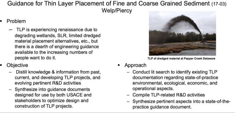
11 Thin Layer Placement 11
12 12

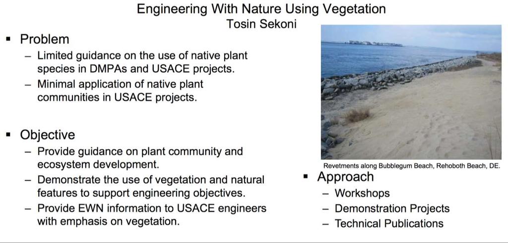
13 Developing Guidance for Incorporating Natural and Nature-based features into Engineering Design 13

14 Dredging and Dredged Material Management Decision Support Tool 14
15 15
 Wiggins Charles.E.Wiggins@usace.")
16 16 Selected ERDC Navigation Technical Director Charles (Eddie) Wiggins
Navigation RD&T Highlights
 Navigation RD&T Highlights W. Jeff Lillycrop Technical Director, Navigation Engineering Research and Development Center U.S. Army Corps of Engineers 22 July 2014 Vicksburg, MS US Army Corps of Engineers
Corps Dredge Plan 2016 Emily Hughes Env Resources, USACE BUILDING STRONG
 Corps Dredge Plan 2016 Emily Hughes Env Resources, USACE Goodbye Jeff Richter!! Navigation/Operations USACE Goal/Mission: To maintain safe Navigation in Federal Channels using methods that are most (1)
PRESENTATION TITLE. Regional Sediment Management. Common goals for uncommon results. AAPA Facilities Engineering Seminar October 22, 2015
 Regional Sediment Management PRESENTATION TITLE Common goals for uncommon results AAPA Facilities Engineering Seminar October 22, 2015 Presented by: Milan A. Mora, PE Project Manager Water Resources Branch
Inland Waterways Users Board #60. Inland Navigation R&D
 Inland Waterways Users Board #60 Inland Navigation R&D 19 February 2009 Vicksburg, MS Agenda 0845-0900 Welcome Dr. Jeff Holland 0900 0920 Agenda & Navigation R&D Overview Mr. Jeff Lillycrop 0920-0940 Mississippi
Taking RSM to the Next Level
 Taking RSM to the Next Level Q AVG Jackie Keiser Chief, Coastal and Navigation USACE Jacksonville District Q AVG RSM & EWN In-Progress Review 21 July 2014 US Army Corps of Engineers BUILDING STRONG RSM:
United States Coast Guard Office of Navigation Systems
 United States Coast Guard Office of Navigation Systems Future of Navigation Initiatives & Operations R. David Lewald Program Analyst Navigation Systems Office of Navigation Systems U.S. Coast Guard Washington,
COOK INLET NAVIGATION CHANNEL
 COOK INLET NAVIGATION CHANNEL 1-5 COOK INLET NAVIGATION CHANNEL, ALASKA (CWIS NO. 10324, 10534) Condition of Improvement 30 September 2011 AUTHORIZATION: (1) Water Resources Development Act of 1996 (Public
Profile description of the Chair of Ports and Waterways
 Faculty Civil Engineering and Geosciences Department of Hydraulic Engineering Profile description of the Chair of Ports and Waterways 1. Position of the Chair of Ports and Waterways 1.1 Background With
Shore Protection Project Performance Improvement Initiative (S3P2I)
") Shore Protection Project Performance Improvement Initiative (S3P2I) 2005 Tri-Service Infrastructure Conference August 1-5, 2005 St. Louis, MO Presented by: Susan Durden, IWR Authority Military Construction
Shore Protection Project Performance Improvement Initiative (S3P2I) 2005 Tri-Service Infrastructure Conference August 1-5, 2005 St. Louis, MO Presented by: Susan Durden, IWR Authority Military Construction
BookletChart. Chesapeake Bay Pocomoke and Tangier Sounds NOAA Chart A reduced-scale NOAA nautical chart for small boaters
 BookletChart Chesapeake Bay Pocomoke and Tangier Sounds NOAA Chart 12228 A reduced-scale NOAA nautical chart for small boaters When possible, use the full-size NOAA chart for navigation. Published by the
(P.27)
") (P.27) 27 7 210 120 8 * Navigation and Anchoring Prohibited Area has been changed since June, 2017. 9 Port of Osaka The Guidelines of Measures for preventing Typhoon Disaster ( Objective )
(P.27) 27 7 210 120 8 * Navigation and Anchoring Prohibited Area has been changed since June, 2017. 9 Port of Osaka The Guidelines of Measures for preventing Typhoon Disaster ( Objective )
RSM Program Update. Linda S. Lillycrop RSM Program Manager. Jeff McKee HQ, Proponent Navigation Business Line Manager Q AVG
 Linda S. Lillycrop RSM Program Manager RSM Program Update Jeff McKee HQ, Proponent Navigation Business Line Manager Jeff Lillycrop ERDC Technical Director, Navigation & Civil Works Q AVG Eddie Wiggins
7/8/13. The Port Authority of Winona June 27, q The Port Authority was established by the City in 1968 with approval of the State Legislature.
 The Port Authority of Winona June 27, 2013 q The Port Authority was established by the City in 1968 with approval of the State Legislature. q The Port Authority serves as the economic development arm of
Prepared by Battelle Memorial Institute
 Final Independent External Peer Review Report Houston Ship Channel Expansion Channel Improvement Project, Harris, Chambers, and Galveston Counties, Texas, Draft Integrated Feasibility Report and Environmental
2012 STATUS REPORT NJ BEACHES AND INLETS PHILADELPHIA DISTRICT, USACE
 2012 STATUS REPORT NJ BEACHES AND INLETS PHILADELPHIA DISTRICT, USACE Jeff Gebert, Coastal Planning, USACE Philadelphia Philadelphia District Established 1866 Delaware River Basin Parts of 5 states 9 million
Port Security and Technology - the U.S. Perspective. Michael S. Bruno Stevens Institute of Technology March 14, 2012
 Port Security and Technology - the U.S. Perspective Michael S. Bruno Stevens Institute of Technology March 14, 2012 CSR A Department of Homeland Security National Center of Excellence for Port Security
WARTSILA AUTONOMOUS VESSEL ADVANCES
 WARTSILA AUTONOMOUS VESSEL ADVANCES NAMEPA 28 FEBRUARY 2018 HOUSTON, TX Kevin Humphreys Business Development Manager - Americas Wartsila North America Mobile +1 757 478 8117 kevin.humphreys@wartsila.com
Innovative Approaches in Collaborative Planning
 Innovative Approaches in Collaborative Planning Lessons Learned from Public and Private Sector Roadmaps Jack Eisenhauer Senior Vice President September 17, 2009 Ross Brindle Program Director Energetics
June 24, Prepared by Battelle Memorial Institute
 June 24, 2013 Final Independent External Peer Review Report Draft Integrated Feasibility Report and Environmental Impact Statement Lake Worth Inlet, Palm Beach Harbor Prepared by Battelle Memorial Institute
Kristin Decas Port of Hueneme Executive Director
 Kristin Decas Port of Hueneme Executive Director Humboldt Bay and Conservation District San Francisco Bay Area Port of West Sacramento Port of Stockton Inland River Ports Port of Oakland Port of San Francisco
BookletChart. Intracoastal Waterway Grassy Key to Bahia Honda Key NOAA Chart A reduced-scale NOAA nautical chart for small boaters
 BookletChart Intracoastal Waterway Grassy Key to Bahia Honda Key NOAA Chart 11453 A reduced-scale NOAA nautical chart for small boaters When possible, use the full-size NOAA chart for navigation. Published
Coastal Imaging of Morphology
 Coastal Imaging of Morphology Katherine Brodie 1, Margaret Palmsten 2, Jenna Long 3, and Brittany Bruder 1 1 U.S. Army Engineer Research and Development Center, Coastal and Hydraulics Laboratory, Duck,
ISO/IEC JTC1/WG11 (IT aspects of) Smart Cities
 Smart Cities") Location Powers; Our Urban Environment ISO/IEC JTC1/WG11 (IT aspects of) Smart Cities Name: Title: Organisation: Email: Peter Parslow Principal Data Architect / Open Standards Lead Ordnance Survey peter.parslow@os.uk
Location Powers; Our Urban Environment ISO/IEC JTC1/WG11 (IT aspects of) Smart Cities Name: Title: Organisation: Email: Peter Parslow Principal Data Architect / Open Standards Lead Ordnance Survey peter.parslow@os.uk
THE PORT OF VIRGINIA:
 THE PORT OF VIRGINIA: A CATALYST FOR COMMERCE JOHN F. REINHART CEO AND EXECUTIVE DIRECTOR August 23, 2016 Stewards of Tomorrow 1 OUR TERMINALS VIRGINIA INLAND PORT RICHMOND MARINE TERMINAL NEWPORT NEWS
GLMTF November 18, 2014 Presentation
 GLMTF November 18, 2014 Presentation Michigan Security Network Founded by major corporations, industry leaders and leading universities in 2008 as a non-profit organization (501c6). MiSN mission is to
ROUTEING OF SHIPS, SHIP REPORTING AND RELATED MATTERS. New traffic separation schemes and two-way routes in Norra Kvarken
 E SUB-COMMITTEE ON SAFETY OF NAVIGATION 57th session Agenda item 3 NAV 57/3/7 11 March 2011 Original: ENGLISH ROUTEING OF SHIPS, SHIP REPORTING AND RELATED MATTERS New traffic separation schemes and two-way
DEPARTMENT OF THE ARMY U.S. ARMY CORPS OF ENGINEERS 441 G STREET, NW WASHINGTON, DC
 REPLY TO ATTENTION OF DEPARTMENT OF THE ARMY U.S. ARMY CORPS OF ENGINEERS 441 G STREET, NW WASHINGTON, DC 20314-1000 CECW-CE 31 March 2014 MEMORANDUM FOR RECORD SUBJECT: EM 1110-2-1304, Civil Works Construction
Annex III - 3. Memorandum of Understanding on the development of the Pan-European Transport Corridor VII (The Danube) (DRAFT)
 (DRAFT)") Annex III - 3 Memorandum of Understanding on the development of the Pan-European Transport Corridor VII (The Danube) (DRAFT) Desiring to promote international transport of goods and passengers through
Annex III - 3 Memorandum of Understanding on the development of the Pan-European Transport Corridor VII (The Danube) (DRAFT) Desiring to promote international transport of goods and passengers through
Southeast O ahu (SEO) Regional Sediment Management (RSM) Workshop #2 June 1, 2005 Ko olau Golf Course
 Regional Sediment Management (RSM) Workshop #2 June 1, 2005 Ko olau Golf Course") Southeast O ahu (SEO) Regional Sediment Management (RSM) Workshop #2 June 1, 2005 Ko olau Golf Course 1 June 2005 Southeast O ahu RSM Workshop #2 1 Agenda Welcome and Introductions Mr. Sam Lemmo Summary
Southeast O ahu (SEO) Regional Sediment Management (RSM) Workshop #2 June 1, 2005 Ko olau Golf Course 1 June 2005 Southeast O ahu RSM Workshop #2 1 Agenda Welcome and Introductions Mr. Sam Lemmo Summary
Engineered Resilient Systems NDIA Systems Engineering Conference October 29, 2014
 Engineered Resilient Systems NDIA Systems Engineering Conference October 29, 2014 Jeffery P. Holland, PhD, PE (SES) ERS Community of Interest (COI) Lead Director, US Army Engineer Research and Development
Recent Developments in NOAA s Real- Time Coastal Observing Systems for Safe and Efficient Maritime Transportation
 Recent Developments in NOAA s Real- Time Coastal Observing Systems for Safe and Efficient Maritime Transportation Rich Edwing, Director NOAA Center for Operational Oceanographic Products and Services CMTS
LT Matthew Forney, NOAA Navigation Manager Alaska Region Bering Strait MaritimeSymposium. Office of Coast Survey
 NOAA LT Matthew Forney, NOAA Navigation Manager Alaska Region Bering Strait MaritimeSymposium Who is Coast Survey? First science agency of the U.S. Formed in 1807 Responsible for surveying 3.4 million
BookletChart. Sacramento River Sacramento to Fourmile Bend NOAA Chart A reduced-scale NOAA nautical chart for small boaters
 BookletChart Sacramento River Sacramento to Fourmile Bend NOAA Chart 18664 A reduced-scale NOAA nautical chart for small boaters When possible, use the full-size NOAA chart for navigation. Included Area
How to Conduct a Bridge to Bridge Inspection
 How to Conduct a Bridge to Bridge Inspection 80.1001 Applicability. The Bridge-to-Bridge Act and the regulations of this part apply to the following vessels in the navigable waters of the United States:
Philadelphia District: Cape May County, New Jersey
 ERDC/RSM-DB6, June 2003 Regional Sediment Management (RSM) Demonstration Program Project Brief Philadelphia District: Cape May County, New Jersey ISSUE The Atlantic coast of New Jersey extends from Sandy
Assessing the Performance of Integrated Corridor Management (ICM) Strategies
 Strategies") Assessing the Performance of Integrated Corridor Management (ICM) Strategies Matt Burt, Battelle Research and Evaluation Session, NATMEC 2012 June 7, 2012 1 Presentation Outline The U.S. DOT ICM Program
Assessing the Performance of Integrated Corridor Management (ICM) Strategies Matt Burt, Battelle Research and Evaluation Session, NATMEC 2012 June 7, 2012 1 Presentation Outline The U.S. DOT ICM Program
REVIEW PLAN (KALAELOA) BARBERS POINT HARBOR MODIFICATION PROJECT ISLAND OF OʻAHU, HAWAIʻI
 BARBERS POINT HARBOR MODIFICATION PROJECT ISLAND OF OʻAHU, HAWAIʻI") (KALAELOA) BARBERS POINT HARBOR MODIFICATION PROJECT ISLAND OF OʻAHU, HAWAIʻI Feasibility Report Section 301 of the Rivers and Harbors Act of 27 October 1965 Public Law (PL) 89-298 U.S. Army Corps of Engineers,
(KALAELOA) BARBERS POINT HARBOR MODIFICATION PROJECT ISLAND OF OʻAHU, HAWAIʻI Feasibility Report Section 301 of the Rivers and Harbors Act of 27 October 1965 Public Law (PL) 89-298 U.S. Army Corps of Engineers,
Statement of Experience. Ocean driven. OFFSHORE VESSELS ONSHORE LOGISTICS ROPES & MOORINGS COMMERCIAL DIVING
 Statement of Experience Ocean driven. OFFSHORE VESSELS ONSHORE LOGISTICS ROPES & MOORINGS COMMERCIAL DIVING Jetwave Marine Services Jetwave Marine Services Pty Ltd is an Exmouth based company offering
BookletChart. Island of O ahu NOAA Chart A reduced-scale NOAA nautical chart for small boaters
 BookletChart Island of O ahu NOAA Chart 19357 A reduced-scale NOAA nautical chart for small boaters When possible, use the full-size NOAA chart for navigation. Included Area Published by the National Oceanic
Lakes and Rivers Division, David Dale
 Locks and Dams 2, 3, and 4 Monongahela River, PA (Lower Mon Project) Inland Waterways Users Board Lakes and Rivers Division, David Dale November 2014 David Dale, PE, PMP Braddock Dam US Army Corps of Engineers
BookletChart. Sacramento River Andrus Island to Sacramento NOAA Chart A reduced-scale NOAA nautical chart for small boaters
 BookletChart Sacramento River Andrus Island to Sacramento NOAA Chart 18662 A reduced-scale NOAA nautical chart for small boaters When possible, use the full-size NOAA chart for navigation. Included Area
E-Navigation: Opening the door to the future
 International Association of Marine Aids to Navigation and Lighthouse Authorities E-Navigation: Opening the door to the future E-Navigation Underway North America November 2018 Secretary-General Francis
11 th CHRIS MEETING IHB, Monaco, November Draft - - -
 CHRIS/11/16A 11 th CHRIS MEETING IHB, Monaco, 16-18 November 1999 - - - Draft - - - Workshop on Development of Marine Information Objects (MIO) for ECDIS Burlington, Ontario, Canada 8-9 November 1999 Record
A Roadmap for Commercializing Microgrids in California
 A Roadmap for Commercializing Microgrids in California October 2, 2017 Mike Gravely California Energy Commission Jose Aliaga-Caro California Public Utilities Commission Peter Klauer California Independent
RESOLUTION MSC.278(85) (adopted on 1 December 2008) ADOPTION OF THE NEW MANDATORY SHIP REPORTING SYSTEM "OFF THE COAST OF PORTUGAL - COPREP"
 (adopted on 1 December 2008) ADOPTION OF THE NEW MANDATORY SHIP REPORTING SYSTEM OFF THE COAST OF PORTUGAL - COPREP") MSC 85/26/Add.1 RESOLUTION MSC.278(85) SYSTEM OFF THE COAST OF PORTUGAL COPREP THE MARITIME SAFETY COMMITTEE, RECALLING Article 28 of the Convention on the International Maritime Organization concerning
MSC 85/26/Add.1 RESOLUTION MSC.278(85) SYSTEM OFF THE COAST OF PORTUGAL COPREP THE MARITIME SAFETY COMMITTEE, RECALLING Article 28 of the Convention on the International Maritime Organization concerning
Meeting Report. PORT ORFORD MARINE ECONOMIC DEVELOPMENT PROJECT TEAM Monday, May 12, 2008 American Legion Hall
 Meeting Report PORT ORFORD MARINE ECONOMIC DEVELOPMENT PROJECT TEAM Monday, May 12, 2008 American Legion Hall Mayor Jim Auborn called the meeting to order at 1 PM. He welcomed everyone and then asked each
October 25, John Coleman, Executive Director Bay Planning Coalition
 October 25, 2012 John Coleman, Executive Director Bay Planning Coalition Northern California Port Data Port of Oakland 5 th busiest seaport in the nation 35 th busiest airport in the nation Economic Impacts
BookletChart. St. Joseph and Benton Harbor NOAA Chart A reduced-scale NOAA nautical chart for small boaters
 BookletChart St. Joseph and Benton Harbor NOAA Chart 14930 A reduced-scale NOAA nautical chart for small boaters When possible, use the full-size NOAA chart for navigation. Included Area Published by the
Invitation to Participate
 Invitation to Participate JOIN US IN THE UNLIMITED RESILIENT DIGITAL CONNECTIVITY Invitation to Participate The Global Space Economy is worth more than $400 billion and set to grow dramatically. The SmartSat
Policy Research Corporation
 Policy Research Corporation SOUND SOLUTIONS BASED ON SCIENTIFIC RESEARCH The role of Maritime Clusters to enhance the strength and development of maritime sectors Country report Denmark INTRODUCTION TO
RESTORE Act Bucket 2 Planning Public Meeting
 RESTORE Act Bucket 2 Planning Public Meeting James C. Gibeaut, Ph.D. Coastal and Marine Geospatial Sciences Harte Research Institute for Gulf of Mexico Studies Texas A&M University Corpus Christi Public
Western Region enavigation Sub- Committee Report
 Western Region enavigation Sub- Committee Report Western Region enavigation meeting - Jan 12 18 BC Ferries BC Coast Pilots BCIT Marine Campus Canadian Coast Guard Canadian Hydrographic Services Canadian
Policy Research Corporation
 Policy Research Corporation SOUND SOLUTIONS BASED ON SCIENTIFIC RESEARCH The role of Maritime Clusters to enhance the strength and development of maritime sectors Country report Poland INTRODUCTION TO
Financing the Future: Financial Performance, Modernization and Funding Options for the Port Authority's Staten Island Bridges
 Financing the Future: Financial Performance, Modernization and Funding Options for the Port Authority's Staten Island Bridges Thomas Brigandi And Dr. Jonathan Peters The City University of New York The
REVIEW PLAN. Panama City Harbor, Florida. Channel Deepening, Limited Reevaluation Report (LRR) P2: Mobile District.
 P2: Mobile District.") REVIEW PLAN Panama City Harbor, Florida Channel Deepening, Limited Reevaluation Report (LRR) P2: 395107 Mobile District December 2012 MSC Approval Date: Pending Last Revision Date: NA REVIEW PLAN Panama
REVIEW PLAN Panama City Harbor, Florida Channel Deepening, Limited Reevaluation Report (LRR) P2: 395107 Mobile District December 2012 MSC Approval Date: Pending Last Revision Date: NA REVIEW PLAN Panama
A Study on Basic VTS Guideline based on Ship s Operator s Consciousness
 http://www.transnav.eu the International Journal on Marine Navigation and Safety of Sea Transportation Volume 11 Number 4 December 2017 DOI: 10.12716/1001.11.04.04 A Study on Basic VTS Guideline based
Statement of Corporate Intent
 2018-23 Statement of Corporate Intent Building and maintaining Australia s frontline naval assets. www.asc.com.au 02 STATEMENT OF CORPORATE INTENT 2018-2023 ASC Pty Ltd About ASC ASC Pty Ltd is a proprietary
GNSS Training for ITS Developers. Characterisation of EGNSS performances in relationship with the application requirements
 GNSS Training for ITS Developers Characterisation of EGNSS performances in relationship with the application requirements Table of Content egnss for Application: Main Challenges EGNOS and GALILEO Performances
VHF Data Exchange System (VDES)
") VHF Data Exchange System (VDES) ETSI Workshop Future Evolution of Marine Communication 7-8 November 2017 Malcolm Lyman Marketing Manager CML Microcircuits UK With acknowledgments to the members of IALA
VHF Data Exchange System (VDES) ETSI Workshop Future Evolution of Marine Communication 7-8 November 2017 Malcolm Lyman Marketing Manager CML Microcircuits UK With acknowledgments to the members of IALA
Selecting Wave Gauge Sites for Monitoring Harbor Oscillations: A Case Study for Kahului Harbor, Hawaii
 Miscellaneous Paper CERC-94-10 May 1994 Selecting Wave Gauge Sites for Monitoring Harbor Oscillations: A Case Study for Kahului Harbor, Hawaii by Michele Okihiro, R. T. Guza, W. C. O'Reilly Scripps Institution
SMART PLACES WHAT. WHY. HOW.
 SMART PLACES WHAT. WHY. HOW. @adambeckurban @smartcitiesanz We envision a world where digital technology, data, and intelligent design have been harnessed to create smart, sustainable cities with highquality
REVIEW PLAN. Wilmington Harbor Draft Integrated Dredged Material Management Plan and EA. Wilmington District
 REVIEW PLAN Wilmington Harbor Draft Integrated Dredged Material Management Plan and EA Wilmington District MSC Approval Date: 5 March 2014 Last Revision Date: N/A REVIEW PLAN Wilmington Harbor, Wilmington,
PNWA 2013 SUMMER CONFERENCE: USACE PORTLAND DISTRICT UPDATE
 PNWA 2013 SUMMER CONFERENCE: USACE PORTLAND DISTRICT UPDATE Michael E. Ott, P.E., PMP, USACE Portland District June 24-26, 2013 La Conner, WA US Army Corps of Engineers Agenda Inland Navigation System
SUBHARMONIC GENERATION OF TRANSVERSE OSCILLATIONS INDUCED BY INCIDENT REGULAR WAVES. Gang Wang 1 and Jin-Hai Zheng 2
 SUBHARMONIC GENERATION OF TRANSVERSE OSCILLATIONS INDUCED BY INCIDENT REGULAR WAVES Gang Wang 1 and Jin-Hai Zheng It is generally accepted that there are transverse oscillation, which are concentrated
1. Qualitative Assessment... II-101
 Table of Contents I. Introduction... I-1 A. Session Law 2009-479 / House Bill 709... I-2 B. Public Consultation... I-3 C. Selection of Study Sites... I-5 D. Limitations of Study... I-8 II. Physical Assessment...
PORT OF POOLE DEVELOPING FOR THE FUTURE
 PORT OF POOLE DEVELOPING FOR THE FUTURE Nick Clarke & Kim Moore INTRODUCTION Masterplan the benefits EIA & SEA (Strategic Environmental ) Changes in Marine Licensing. PORT DEVELOPMENT PROCESS Development
NRC s Approach to Foresight and Competitive Intelligence
 NRC s Approach to Foresight and Competitive Intelligence Evan W. Steeg, PhD Director, NRC Foresight I-CAN Innovation School, Module 4 24 October 2013 A Wondrous, Volatile, Dynamic Future Global Trends
Annex 11 to Working Party 5B Chairman s Report WORKING DOCUMENT TOWARDS A PRELIMINARY DRAFT NEW REPORT ITU-R M.[SNAP]
![Annex 11 to Working Party 5B Chairman s Report WORKING DOCUMENT TOWARDS A PRELIMINARY DRAFT NEW REPORT ITU-R M.[SNAP]](/thumbs/92/108810182.jpg "Annex 11 to Working Party 5B Chairman s Report WORKING DOCUMENT TOWARDS A PRELIMINARY DRAFT NEW REPORT ITU-R M.[SNAP]") Radiocommunication Study Groups Source: Document 5B/TEMP/287 Annex 11 to Document 5B/617-E 29 November 2010 English only Annex 11 to Working Party 5B Chairman s Report WORKING DOCUMENT TOWARDS A PRELIMINARY
Radiocommunication Study Groups Source: Document 5B/TEMP/287 Annex 11 to Document 5B/617-E 29 November 2010 English only Annex 11 to Working Party 5B Chairman s Report WORKING DOCUMENT TOWARDS A PRELIMINARY
Mid-Frequency Reverberation Measurements with Full Companion Environmental Support
 DISTRIBUTION STATEMENT A. Approved for public release; distribution is unlimited. Mid-Frequency Reverberation Measurements with Full Companion Environmental Support Dajun (DJ) Tang Applied Physics Laboratory,
Evaluation of Strategic Area: Marine and Maritime Research. 1) Strategic Area Concept
 Strategic Area Concept") Evaluation of Strategic Area: Marine and Maritime Research 1) Strategic Area Concept Three quarters of our planet s surface consists of water. Our seas and oceans constitute a major resource for mankind,
Evaluation of Strategic Area: Marine and Maritime Research 1) Strategic Area Concept Three quarters of our planet s surface consists of water. Our seas and oceans constitute a major resource for mankind,
MINUTES REGULAR COMMISSION MEETING THE PORT OF PORTLAND June 13, 2012
 35 MINUTES REGULAR COMMISSION MEETING THE PORT OF PORTLAND June 13, 2012 In response to due notice, the regular meeting of the Commissioners of the Port of Portland was held at 9:30 a.m. in the Chinook
Development of Mid-Frequency Multibeam Sonar for Fisheries Applications
 Development of Mid-Frequency Multibeam Sonar for Fisheries Applications John K. Horne University of Washington, School of Aquatic and Fishery Sciences Box 355020 Seattle, WA 98195 phone: (206) 221-6890
Benefits and Impacts to Nautical Charting by Adopting a New Reference Frame. Dr. Neil Weston Office of Coast Survey, NOAA
 Benefits and Impacts to Nautical Charting by Adopting a New Reference Frame Dr. Neil Weston Office of Coast Survey, NOAA Motivation for this study NOAA s National Geodetic Survey New geometric reference
DRAFT. SEDAR 58 Atlantic Cobia Benchmark Assessment: Cobia Stock ID Workshop Overall Recommendations
 Southeast Fisheries Science Center SEDAR 58 Atlantic Cobia Benchmark Assessment: Cobia Stock ID Workshop Overall Recommendations SEDAR 58 Atlantic Cobia Stock ID Review Workshop June 5, 2018 Tour du ToRs
Rail Transit Connected Vehicles & Ultra-wideband for Communications & Location
 Rail Transit Connected Vehicles & Ultra-wideband for Communications & Location Abstract Ultra-Wideband (UWB) can provide centimeter accuracy location for all the cars in the tunnels with very low cost
DfT Maritime Directorate Our work on port policy
 DfT Maritime Directorate Our work on port policy October 18 Port Connectivity Study - Implementation Plan 1 DfT Maritime Directorate has six strategic objectives all are relevant to ports Maintaining a
We wish you a Happy New Year!
 NEWSLETTER No. 3 I January 2014 Programme co-funded by the European Union NEWADA duo Network of Danube Waterway Administrations - data and user orientation is an EU project, funded under the South East
Application Of Ripple Tank To Studies Coefficient Of Wave Transmission Through Vertical Barrier
 Available Online at http://ircconferences.com/ Book of Proceedings published by (c) International Organization for Research and Development IORD ISSN: 2410-5465 Book of Proceedings ISBN: 978-969-7544-00-4
Research and Statistics Department FOR RELEASE 8:50 A.M. Monday, May 28, 2018
 Bank of Japan Research and Statistics Department FOR RELEASE 8:50 A.M. Monday, May 28, 2018 Report on the Services Producer Price ( Preliminary Figures for April 2018 ) The Services Producer Price (All
Call for Papers. Special Issue of Journal of Transportation Security. Maritime Security: Current and Future Challenges
 Call for Papers Special Issue of Journal of Transportation Security Maritime Security: Current and Future Challenges Guest Editors: Chief Editor: Dr. Simon Véronneau, PhD, RAND Corporation Assistant Editor:
BookletChart. Port-au-Prince (Haiti) NGA Chart A reduced-scale NGA nautical chart for small boaters
 NGA Chart A reduced-scale NGA nautical chart for small boaters") BookletChart Port-au-Prince (Haiti) NGA Chart 26186 A reduced-scale NGA nautical chart for small boaters When possible, use the full-size NGA chart or Electronic Nautical Chart (ENC) for navigation. VHF
BookletChart Port-au-Prince (Haiti) NGA Chart 26186 A reduced-scale NGA nautical chart for small boaters When possible, use the full-size NGA chart or Electronic Nautical Chart (ENC) for navigation. VHF
Captain Michael Reagoso McAllister Towing (Tug Boat Operator)
") Captain Michael Reagoso McAllister Towing (Tug Boat Operator) Meet Michael Reagoso Hi, I m Mike Reagoso, Vice President of McAllister Towing of Baltimore. McAllister Towing is a large company that operates
Captain Michael Reagoso McAllister Towing (Tug Boat Operator) Meet Michael Reagoso Hi, I m Mike Reagoso, Vice President of McAllister Towing of Baltimore. McAllister Towing is a large company that operates
How Automatic Identification System (AIS) Is Being Used to Improve Navigation Safety Lock Operations Management Application Michael Winkler
 Is Being Used to Improve Navigation Safety Lock Operations Management Application Michael Winkler") How Automatic Identification System (AIS) Is Being Used to Improve Navigation Safety Lock Operations Management Application Michael Winkler June 2016 LOMA system overview USCG AIS data capabilities: AIS
How Automatic Identification System (AIS) Is Being Used to Improve Navigation Safety Lock Operations Management Application Michael Winkler June 2016 LOMA system overview USCG AIS data capabilities: AIS
NAPA User Meeting 2017
 1 (7) DAY 1 TUESDAY 6 JUNE 2017 9:00-10:30 Words of welcome Product News 2017 This presentation gives insight on the latest new features in NAPA and future plans of our solutions. 10:30-11:00 COFFEE 11:00-12:30
PRESENTATION TITLE. A look back. A path forward. March 23, Stewards of Tomorrow 1
 PRESENTATION TITLE 2016 STATE Subtitle Goes OF Here THE PORT A look back. A path forward. March 23, 2016 Stewards of Tomorrow 1 WE HANDLED MORE VOLUME THAN EVER BEFORE. Stewards of Tomorrow 2 TOTAL POV
Exit point. Can you do it?
 Can you do it? Don t just guess, Be precise! Horizontal directional drilling is a specialized profession nowadays. The days when directional drilling was ruled by assumptions, are far behind us. Clients
NEW YORK STATE TEACHER CERTIFICATION EXAMINATIONS
 NEW YORK STATE TEACHER CERTIFICATION EXAMINATIONS TEST DESIGN AND FRAMEWORK June 2018 Authorized for Distribution by the New York State Education Department This test design and framework document is designed
IALA S WORK IN E-NAVIGATION. Michael Card
 IALA S WORK IN E-NAVIGATION Michael Card e-navigation origins The early work of IALA on e-navigation Multiple Initiatives EfficienSea 2 STM Validation IHO S-100 and IALA S-200 Smart Navigation VDES development
DEVELOPMENT OF A DEFINITION FOR MSPS AND CONSIDERATION FOR THE HARMONIZATION OF THE FORMAT AND STRUCTURE OF MSPS
 INTERNATIONAL HYDROGRAPHIC ORGANIZATION E IMO/IHO HARMONIZATION GROUP ON DATA MODELLING Agenda item 5 15 September 2017 ENGLISH ONLY DEVELOPMENT OF A DEFINITION FOR MSPS AND CONSIDERATION FOR THE HARMONIZATION
Coastal Engineering 2006, ASCE MODELING TSUNAMI AND RESONANCE RESPONSE OF ALBERNI INLET, BRITISH COLUMBIA
 Coastal Engineering 006, ASCE MODELING TSNAMI AND RESONANCE RESPONSE OF ALBERNI INLET, BRITISH COLMBIA Dilip K. Barua, Norman F. Allyn and Michael C. Quick A computational model is developed using MIKE-FM
ISO TC 268. Participating countries: 29 Observing countries: 22
 ISO TC 268 Standardization in the field of Sustainable Cities and Communities including development of requirements, frameworks, guidance, supporting techniques and tools related to the achievement of
Channel Safety Assessment in Ship Navigation Based on Fuzzy. Logic Model
 Wu et al. 0 0 0 Channel Safety Assessment in Ship Navigation Based on Fuzzy Logic Model Yuan Wu School of Naval Architecture, Ocean and Civil Engineering Shanghai Jiao Tong University 00 Dongchuan Road,
NOAA Navigation Services Update
 NOAA Navigation Services Update Captain Jim Crocker Chief, Navigation Services Division NOAA s More than Two Centuries of Service First U.S. gov t science agency President Thomas Jefferson created the
Research and Statistics Department FOR RELEASE 8:50 A.M. Thursday, October 26, 2017
 Bank of Japan Research and Statistics Department FOR RELEASE 8:50 A.M. Thursday, October 26, 2017 Report on the Services Producer Price ( Preliminary Figures for September 2017 ) The Services Producer
Scoping Paper for. Horizon 2020 work programme Societal Challenge 4: Smart, Green and Integrated Transport
 Scoping Paper for Horizon 2020 work programme 2018-2020 Societal Challenge 4: Smart, Green and Integrated Transport Important Notice: Working Document This scoping paper will guide the preparation of the
A Rising Tide: Conserving Shorebirds and Shorebird Habitat within the Columbia River Estuary
 A Rising Tide: Conserving Shorebirds and Shorebird Habitat within the Columbia River Estuary By Vanessa Loverti USFWS Migratory Birds and Habitat Programs, Portland, Oregon May 28, 2014 Outline of Talk
Kurt Gerdes, and Steven P. Schneider Office of Engineering and Technology Office of Environmental Management U.S. Department of Energy
 Risk Reduction through Use of External Technical Reviews, Technology Readiness Assessments and Technical Risk Ratings - 9174 ABSTRACT Kurt Gerdes, and Steven P. Schneider Office of Engineering and Technology
The ship RV Timba repairs are now almost complete and it is expected that come September 2014 the ship will be fully operational.
 Malawi National Report 2014 1 Malawi Hydrographic Office The assembly of the 70 ton ship RV Timba with the assistance of the French government in 1989 ushered in the commencement of modern hydrographic
PASSIVE ACOUSTIC UNDERWATER NOISE MEASUREMENTS IN CONSTANTA PORT AREA
 PASSIVE ACOUSTIC UNDERWATER NOISE MEASUREMENTS IN CONSTANTA PORT AREA Mihail PRICOP 1 Tiberiu PAZARA 2 Codruta PRICOP 3 Dinu ATODIRESEI 4 Ionuț-Cristian SCURTU 5 1 Associate Professor, Mircea cel Batran
Earth Cube Technical Solution Paper the Open Science Grid Example Miron Livny 1, Brooklin Gore 1 and Terry Millar 2
 Earth Cube Technical Solution Paper the Open Science Grid Example Miron Livny 1, Brooklin Gore 1 and Terry Millar 2 1 Morgridge Institute for Research, Center for High Throughput Computing, 2 Provost s