25 Years of Contributions by INPHO to Advancement in Photogrammetry - What is to come next?
|
|
|
- Damon Elliott
- 5 years ago
- Views:
Transcription
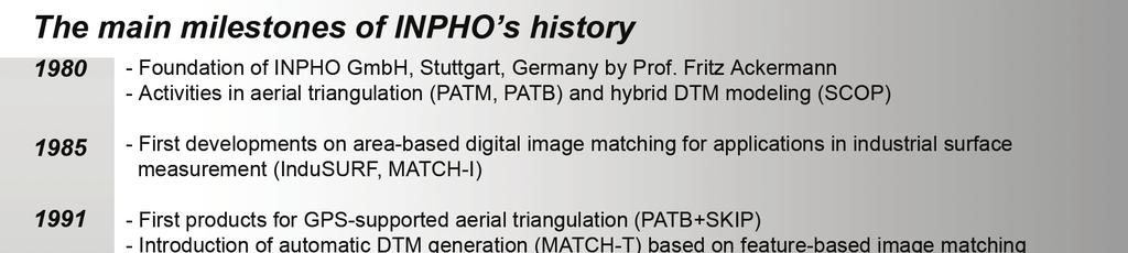
1 'Photogrammetric Week 05' Dieter Fritsch, Ed. Wichmann Verlag, Heidelberg Ackermann Years of Contributions by INPHO to Advancement in Photogrammetry - What is to come next? FRIEDRICH ACKERMANN, Stuttgart ABSTRACT A brief review is given about the transition to computational methods in photogrammetry during the 1970s and about the initial contributions from the Photogrammetric Institute of Stuttgart University. They motivated the foundation of Inpho company for the development and marketing of photogrammetric software programs, aiming at high level performance and innovative products. The company established itself successfully during the first 20 years as a reputed software provider of powerful programs for blockadjustment and digital terrain models in particular. The recent years are characterized by extended performance of the software systems, including utilization of GPS and IMU data and the automation of digital processing systems, and by a strategic re-orientation to become an overall systems provider. Inpho company looks forward to maintain and perhaps expand its field of competence and its market position in the future. 1. INTRODUCTORY REMARK I have been asked to give this short presentation on behalf of Inpho company which is a software company for photogrammetric data processing programs, located here in Stuttgart. It is a partner of the Photogrammetric Week consortium and takes part in the afternoon demonstrations. I myself am not nor have I ever been a member of that company. But I have founded it 25 years ago, in 1980, and have since maintained consulting functions. 2. THE EVOLUTION OF COMPUTATIONAL METHODS Let me briefly recall the situation of photogrammetry, after I had become professor in photogrammetry and surveying at Stuttgart University in 1966 and had founded the Institute of Photogrammetry there. It was just the time when the application of digital computers became feasible, although still in vague anticipation only. Up to that time universities have had no substantial impact on the development or performance of photogrammetry. The operational concepts used to be set by industry, via the design and use of instruments which remained of analog type for some time to come. The only exceptions at the time were the stereo-comparator and Helava s analytical plotter. But in Europe stereo-comparators were not used in practice outside universities, and disappeared soon. And practically nobody knew here what to expect from the analytical plotter. It took more than another 10 years until it developed into the major universal photogrammetric instrument. I had become familiar with the first computers at the ITC in Delft, The Netherlands, where I had worked for 8 years. We had there the clear anticipation that computational methods were needed and were possible in photogrammetry, and that they would not only be useful but would thoroughly change the whole discipline. Today we say that computers set off a new paradigm for surveying and photogrammetry. Computational methods would process, refine, and integrate measured data, relatively independent of the actual measuring instruments. As a side effect it was expected that computational methods would give universities a completely new role in the development and the status of our field. It must be recalled that at the time no
2 14 Ackermann software industry was existing at all. And it still took years until our traditional instrument industry would understand the fundamental changes to come, in the course of which analog photogrammetry would disappear. We started in Stuttgart right away with the development of powerful blockadjustment programs for aerial triangulation. Other institutes did the same, but we had a certain head start. Computational blockadjustment had soon an enormous impact on photogrammetry, by greatly improving the accuracy and the economy of aerial triangulation, the latter via the enormous saving of ground control points. The direct technical problem was the solution of large systems of linear equations with thousands of unknowns, as we aimed from the beginning at handling large blocks, which had not been common previously. We had, like others as well, experimented with iterative solutions (e.g. conjugate gradients), but abandoned them soon in favor of direct solutions. I remember that I approached quite naively our university computing center, expecting that they would have programs for solving systems of linear equations. They had, but none went beyond 100 unknowns. So we had to develop such programs ourselves, with the additional difficulty that even the Control Data 6600, one of the largest computers at the time, had only a for us usable core storage capacity of 50 K (!). Nowadays one cannot make students understand any more what were the actual difficulties. Anyway, 3 years later the first tests with photogrammetric blocks were made. They turned out to be extremely successful, much more than originally expected. Block adjustment provided quickly a great jump in the practical performance of photogrammetry. And our theoretical studies about the distribution of ground control points and their influence on the resulting accuracy of blocks gave a solid basis for the planning and prediction of projects. I do not have to go deeper into the matter, as all is history by now. Blocktriangulation has become a standard procedure. But at that time, in about 1970, it was a great challenge, and the results were met enthusiastically. We are still somewhat proud that our institute in Stuttgart was able to successfully push the frontline of the development, to which naturally other institutes and institutions contributed as well. At the same time we developed at Stuttgart University our first program SCOP for the generation of digital terrain models. It was laid out right from the beginning for large sets of data as could be expected from photogrammetric spot height capture, reaching clearly beyond conventional tacheometry. It was another innovative attempt to advance basic concepts by utilizing powerful computational methods. With the DTM software we made the experience, for the first time, that the mathematical core of the program took only about 20% of the total system, the rest was needed for data handling and ensuring the quality performance. It was our concept from the beginning that the DTM would become a separate new product for terrain description. But the initial key issue was the computational derivation of contour lines. It is interesting that we had great resistance from the cartographic world. At that time most cartographers were not ready to accept computationally derived contour lines, being fixed on the strong belief that designing contours is an act of creative art performed only by human specialists. It needed extensive tests in order to show that the quality of computationally derived contour lines depends in first instance on high performance software and on the quality, distribution, and density of the input data. With enough spot heights, additional break lines, and characteristic features we were able to demonstrate that contour lines could be obtained which were virtually identical with manually drafted contour lines. The described developments took place at the Stuttgart University Institute. In the 1970s the universities were in fact the only institutions which could develop computer methods and software programs. At that time software industry was not yet existing.
3 Ackermann 15 That situation changed gradually during the decade. The first European analytical plotters appeared after Numerical methods had started to become accepted and efficiently applied in practice. Having observed the changing scene I myself had realized that the development of computer methods for practical application would become a standard task of industry and would not any longer constitute a basic task of universities. They should concentrate on fundamental scientific development and evaluation studies and leave the turnover into practical application to the software companies to come. So, we decided to found the Inpho company in 1980, for the development and marketing of photogrammetric computer programs. The relationship with the university, which was still needed, was to be maintained by contracts. In view of the successful previous development the new Inpho company intended strongly to operate in the front line of high quality innovative developments. And that intention has become the trademark of the company. Several of the programs have been the first of its kind. There was a second reason for founding a private company. In the 1970s our local ministry had become influenced by the ideology of the 68 student revolution. As a result contacts of university institutes with industry and application agencies became suspicious. They were nearly forbidden and each project was supposed to be applied for and approved. That tendency was most annoying and certainly counterproductive for all engineering disciplines. It did not last very long. Today the pendulum has swung back completely, and universities are not only allowed but in fact encouraged to acquire money and contracts from outside as much as possible. This goes again too far, in my opinion, as university institutes now can compete in unfair ways with software industry by producing mere application programs, beyond any claim for thorough research. 3. INPHO, THE FIRST 20 YEARS Let me now briefly sketch the first 20 years of Inpho s development. As mentioned, the company was set for high performance innovative developments which were intended to strongly push the practical application of photogrammetry by powerful computerized methods. A number of successful steps can be distinguished which have worked very well: - The first successful software products were the programs PAT-M and PAT-B for blockadjustment with independent models and bundles, extended in particular to robust adjustment for automatic blunder detection and to include GPS camera positioning data. There was initially a certain rivalry between the independent model method and the bundle method. Only when after 1980 the analytical plotters became widely applied the precise measurement of image coordinates became convenient, which moved the bundle method to standard application. By the way, the PAT-M program for independent models had been designed from the beginning to handle blockadjustment with auxiliary statoscope and APR data, together with object conditions (e,g, water level constraints) which greatly saved vertical ground control points for medium and small scale photo blocks. It was again an example of innovative development and specialized performance. - Another important step was the application of self-calibration by additional parameters for the automatic correction of unknown systematic image errors. That method finally pushed the bundle method to most remarkable levels of accuracy performance. It opened the practical application to cadastral photogrammetry on the 3 micron level. - Another success-program was SCOP for digital terrain models. The previous first version was completely reprogrammed at Inpho and particularly adapted to the hard specifications of the German road administration which required combined input of photogrammetric and tacheometric data and rigorous consideration of complex networks of breaklines.
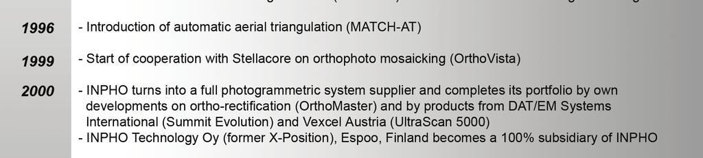
4 16 Ackermann In the meantime the first investigations about digital image matching had taken place at the University Institute. Actually the method of least squares image matching was re-invented. It was found out later that Ukki Helava had previously used the method, but had abandoned it because of its small convergence radius. Anyway, Inpho used the method in its InduSURF program for the automatic digital measurement of car bodies. It was the first nearly fully automatic system for the digital survey and description of an industrial object. The Volkswagen company used it successfully for the design of its car models, for quite some time. A few years later Inpho developed the MATCH-T program, on the basis of least squares image matching and feature matching of digitized imagery, and with the side-condition of extremely dense terrain coverage by elevation points. It was a hard struggle to bring down the originally long computing times for the automatic generation of dense digital terrain models to an economically acceptable performance. Refinements for handling breaklines and other special terrain features had to be considered. But a highly satisfactory level of performance was obtained which was proven in several international tests. Towards the end of the first decade of Inpho s activities two important sensor developments took place. The first was airborne GPS positioning. At the university institute the first tests and experiments were made in 1988, with most promising results. Relative camera positioning accuracies in the order of 10 cm were obtained. Inpho was the first company to implement GPS data into block adjustment. It gave aerial triangulation another push by reducing the required number of ground control for even very large blocks to only very few points, or even none at all. The anticipated success of the method motivated Inpho to carry out a considerable number of practical pilot projects, in cooperation with different photogrammetric production companies, in order to prove and demonstrate the general power of the method under practical conditions of application. The PAT-B program for bundle blockadjustment with GPS positioning data was soon supplemented by the preprogram SKIP for processing the raw GPS data. In the meantime the University Institute of photogrammetry had begun to look into the method of airborne laser profiling, the second sensor development. Initially only vertically pointing laser profilers were available, with very low measuring rates of about Hz only. Side-scanning lasers had not yet been developed. Nevertheless, the first profiling tests in 1988 demonstrated the potential application for terrain measurements in forest areas, for which no other method was feasible. The future extension to airborne laser (lidar) scanning was obvious. The subsequent development of equipment and software for lidar scan application took place in specialized companies (like Topscan, founded by 2 of our university people, after their Dr. promotion). For that reason Inpho integrated lidar data filtering in its SCOP++ software (developed at the University of Vienna, Prof. Kraus) only very much later, when finally the data processing and DTM generation could be separated from particular equipment specifications. In 1996 the program MATCH-AT was launched for automatic aerial triangulation measurements in combination with blockadjustment. It operated on digital workstations which had gradually come into the photogrammetric scene, replacing the analytical plotters. The program solved for the first time the automatic selection, the transfer, and the measurement of tie-points as input for the online blockadjustment with large clusters of tie-points. It was another essential performance step into digital photogrammetry.


5 Ackermann 17


6 18 Ackermann In looking back it can be stated that Inpho had developed very well during the first 20 years of its existence and established itself successfully as a reputed company with generally applicable software products of high quality and innovative nature which have substantially contributed to the fast evolution of photogrammetry by computational and digital methods. The philosophy to provide high level innovative working methods had succeeded very well. Inpho marketed its software to end-users directly, but also had OEM distribution via partners. However, Inpho was essentially a component provider as the products mainly covered certain important components of the photogrammetric workflow. 4. THE RECENT YEARS At about after 1995 the industrial scene of the instrument manufacturers and their concepts started to change, as well as the application and the market scene. It became evident that Inpho had to alter its previous philosophy and move from a component supplier to a photogrammetric systems provider. This meant in first instance, as far as software products are concerned, new and integrated means for effective and versatile orthophoto production programs. The present programs OrthoMaster and OrthoVista are the results of such efforts. They cover the whole range of practical orthophoto production, including fast rectification, color balancing, handling of very large orthomap systems, and seamless mosaicking. They represent today a major product line of Inpho. Along the same philosophy also the PAT programs for blockadjustment had to be reconsidered, which had served very well for nearly 30 years. They were dropped in favor of the completely new inblock program for universal blockadjustment, which includes GPS and IMU data and robust adjustment, and can display graphs for universal accuracy and reliability assessment. In addition to new internal software developments it became advisable to look for a partner company in order to include interactive digital data capture and cover a larger range of the photogrammetric workflow. We found a partner in DAT/EM Systems International from Anchorage. Their digital stereo-plotter Summit Evolution became our universal data capture equipment into which our software components were integrated to achieve a smooth and highly automated workflow, concerning in first instance data capture, automatic INPHO s digital photogrammetric workflow
7 Ackermann 19 aerial triangulation and orientation, terrain modeling and orthophoto generation. The cooperation has worked very well, to the benefit of both partners, who have agreed to sell each other s products. Another agreement was reached with Vexcel Austria, to have also their reputed image scanner Ultra Scan 5000 in Inpho s total concept. Digital cameras were left outside, although there had been some ideas and suggestions for a digital camera of our own. But it is clearly intended that Inpho s processing software would be able to handle data input from any digital camera, in combination with GPS and IMU data. Besides, it has been as standard task to continuously update and refine the performance of practically all software programs. The latest examples are new editions of the MATCH-T program and the SCOP++ program for DTM generation. These programs are demonstrated in the afternoon sessions of this Photogrammetric Week. The new features concern for instance DTMs from multioverlap blocks, abandoning the previous model by model treatment. Particularly effective is the new program DTMaster for editing the new generation of large DTMs which refer to the extremely large amounts of lidar data with the enormously dense distribution of terrain points. In that context also the storage, handling, and administration of very large nationwide DTM and Orthophoto systems has been given close attention. Inpho has certainly made severe efforts to extend and modernize its product line in order to be prepared for the future changes to come. The technical developments went more or less according to plan. But there was a short period where Inpho had some difficulties. It had to do with an external event, namely the fusion of Intergraph with the photogrammetric section of Zeiss Oberkochen, resulting in the foundation of the ZI-Imaging company in Up to that fusion Inpho had licence agreements for MATCH-AT and MATCH-T with Intergraph and one for Match- T with Zeiss. These relationships broke down, due to the decisions of the ZI management, and had to be compensated by intensified efforts. It was in fact the occasion for moving Inpho to the system provider strategy. It operates now on a different platform. It is perhaps symptomatic for a small independent company like Inpho that from time to time the strategic situation is affected by external events and plans, which may require strategic reactions. It is therefore not surprising that during the past years Inpho has been approached by other companies to be bought or go into fusion or other forms of close cooperation. But none of these cases could be agreed to. Inpho wanted to remain independent and self determined. That attitude reflects partly the assessment of our overall status and the intention to retain our experienced and specialized staff. Thus, Inpho has maintained its position and now operates on the basis of a complete integrated package of high performance products which are highly competitive on the market. Therefore the company looks forward with considerable confidence, at least as far as the near future can be foreseen. 5. A LOOK INTO THE FUTURE I am supposed to talk also about the future, although I hesitate very much. The simple reason is, that I do not claim to know the future. And with regard to my personal attitude, after 13 years of retirement, I am tempted to quote the late Professor Thompson from the University college London. Towards the end of his official terms he said once that he cannot understand that he is asked all the time about the future of photogrammetry, because at his age the psychological attitude is not actively oriented towards the future any more, and any major changes can only be to the worse. I

8 20 Ackermann have the same feeling myself. I am not interested personally nor do I believe in long term predictions, in view of the acceleration everywhere. I consider the management of this Photogrammetric Week very courageous, trying to look 25 years ahead. I shall certainly listen most intently whether the speakers in that section will be able to meet the challenge. And, who knows, by Friday this week we may be enlightened or become at least somewhat wiser about what to expect in But, of course, a number of statements about the expected future can be made, at least for a range of some years to come. In that case one may extrapolate to some extent from the present situation. It is particularly important for a company like Inpho to look ahead and to prepare itself in time for future changes, in order to maintain its field and its position of competence. That is a common feature for the present situation of industry in general. The changes are more rapid than in former times, and one has to prepare for and adapt with ideas in time. Looking into the future we must distinguish between the expected effects of the technology development and those of the market and business scene. It is perhaps relatively easy to predict the immediate continuation of the technology status: - There is in first instance the further automation of feature and object extraction from digital imagery, in particular with regard to city modeling. This is already on the way, but certainly not yet finalized. It will require the fusion of digital image data and of lidar data. The software programs, whether completely automatic or to some degree interactive, will have to deal with very large sets of high resolution data. -In the near future the further development and application of digital cameras will continue, also of small format cameras. Companies like Inpho will have to adapt their software to different classes of digital cameras. Also satellite imagery with higher resolution may come, perhaps with pixel terrain resolution of 0.5 m or less. The technology is available, but the time of realisation will depend on financing and market considerations. Higher resolution satellite imagery will not cause great new problems for the existing data processing systems. - The above examples can be taken representative for the general expansion of digital sensor systems and of digital products. It implies in particular lidar data, combined with digital camera data, the latter perhaps extended into the near infrared range. The tendency is in general towards more integrated systems with the challenge for more versatile software systems to handle flexibly and effectively different applications. - Inpho has not been active in the field of remote sensing, so far. It has always been focused on the geometric kernel performance of data and products. Whether this will have to be reconsidered remains to be seen, as thematic and geometric geo-data processing will have to converge. The future development of company strategies and of the application and market situation in our discipline is more difficult to be assessed than the path of technology, at least in my opinion. The technical performance alone may have effects on the market scene and on the attitude of the user communities. In addition independent structural changes may happen, which might thoroughly affect the administrative frames of our fields or touch even the general esteem of geo-information in future societies. Such moves have been going on for some time and have already caused enough
9 Ackermann 21 disturbance. They will certainly continue to the extent that our previously enclosed and stable world of surveying and mapping will disappear completely in favor of more open interrelated structures. This is a certain difficulty, but also chance and challenge. It is the development of Geographic information systems in the widest sense which will dominate the future development, in terms of contents and of effects. Their range goes and will go much beyond the traditional frame of our work. Photogrammetry is directly and mainly concerned with integrated data acquisition and data merging, and with its role in various user systems, whether these are planning systems, general administration, or engineering and monitoring systems. The general tendency towards GIS is clear, in my opinion, but it is too wide a field and split into various subsystems which makes it difficult to anticipate clearly which forms will dominantly emerge. Production companies may have to make decisions on different levels, as the range will extend from simple to most sophisticated systems, up to the level of governmental or national administrations. Perhaps also the user community will disintegrate by different demands. Let me close these superficial considerations and come back to the case of Inpho company. It has so far maintained itself very well and solved the occasional difficulties. It is one of the very few major photogrammetric software companies in Europe which has maintained itself through the turbulent structural changes which have shaken up photogrammetric hardware and software industry, as well as the user communities and their demands. Inpho has certainly the intention to continue its path and to play its part in modern photogrammetry which expands into the vast world of geo-spatial information. We are aware that careful observation and anticipation of developments will be required in order to be able to react in time and stay prepared for the future. I wish and hope that the development of the geo-data field will be intense and provide satisfaction and success to all who are concerned with it. And I may be allowed to wish also Inpho company that it will manage to remain an interesting and successful player in the field, to expand its operational platform, and to maintain a clear field of competence.
UltraCam and UltraMap Towards All in One Solution by Photogrammetry
 Photogrammetric Week '11 Dieter Fritsch (Ed.) Wichmann/VDE Verlag, Belin & Offenbach, 2011 Wiechert, Gruber 33 UltraCam and UltraMap Towards All in One Solution by Photogrammetry ALEXANDER WIECHERT, MICHAEL
EXAMPLES OF TOPOGRAPHIC MAPS PRODUCED FROM SPACE AND ACHIEVED ACCURACY CARAVAN Workshop on Mapping from Space, Phnom Penh, June 2000
 EXAMPLES OF TOPOGRAPHIC MAPS PRODUCED FROM SPACE AND ACHIEVED ACCURACY CARAVAN Workshop on Mapping from Space, Phnom Penh, June 2000 Jacobsen, Karsten University of Hannover Email: karsten@ipi.uni-hannover.de
High Resolution Sensor Test Comparison with SPOT, KFA1000, KVR1000, IRS-1C and DPA in Lower Saxony
 High Resolution Sensor Test Comparison with SPOT, KFA1000, KVR1000, IRS-1C and DPA in Lower Saxony K. Jacobsen, G. Konecny, H. Wegmann Abstract The Institute for Photogrammetry and Engineering Surveys
HIGH RESOLUTION COLOR IMAGERY FOR ORTHOMAPS AND REMOTE SENSING. Author: Peter Fricker Director Product Management Image Sensors
 HIGH RESOLUTION COLOR IMAGERY FOR ORTHOMAPS AND REMOTE SENSING Author: Peter Fricker Director Product Management Image Sensors Co-Author: Tauno Saks Product Manager Airborne Data Acquisition Leica Geosystems
Vexcel Imaging GmbH Innovating in Photogrammetry: UltraCamXp, UltraCamLp and UltraMap
 Photogrammetric Week '09 Dieter Fritsch (Ed.) Wichmann Verlag, Heidelberg, 2009 Wiechert, Gruber 27 Vexcel Imaging GmbH Innovating in Photogrammetry: UltraCamXp, UltraCamLp and UltraMap ALEXANDER WIECHERT,
Helicopter Aerial Laser Ranging
 Helicopter Aerial Laser Ranging Håkan Sterner TopEye AB P.O.Box 1017, SE-551 11 Jönköping, Sweden 1 Introduction Measuring distances with light has been used for terrestrial surveys since the fifties.
DEM Generation Using a Digital Large Format Frame Camera
 DEM Generation Using a Digital Large Format Frame Camera Joachim Höhle Abstract Progress in automated photogrammetric DEM generation is presented. Starting from the procedures and the performance parameters
The Photogrammetric Week Series A Centennial Story of Success
 Institut für Photogrammetrie The Photogrammetric Week Series A Centennial Story of Success Dieter Fritsch Opening The 100th Anniversary of The Photogrammetric Week Series Copyright: Institute for Photogrammetry,
FROM THE FIELD SHEET TO THE COMPLETE DIGITAL WORKFLOW
 FROM THE FIELD SHEET TO THE COMPLETE DIGITAL WORKFLOW Martin Gurtner Swisstopo, Federal Office of Topography, CH-3084 Wabern, Switzerland, martin.gurtner@swisstopo.ch Abstract The Swiss Federal Office
Processing of stereo scanner: from stereo plotter to pixel factory
 Photogrammetric Week '03 Dieter Fritsch (Ed.) Wichmann Verlag, Heidelberg, 2003 Bignone 141 Processing of stereo scanner: from stereo plotter to pixel factory FRANK BIGNONE, ISTAR, France ABSTRACT With
Automated GIS data collection and update
 Walter 267 Automated GIS data collection and update VOLKER WALTER, S tuttgart ABSTRACT This paper examines data from different sensors regarding their potential for an automatic change detection approach.
IGI Ltd. Serving the Aerial Survey Industry for more than 20 Years
 'Photogrammetric Week 05' Dieter Fritsch, Ed. Wichmann Verlag, Heidelberg 2005. Kremer 33 IGI Ltd. Serving the Aerial Survey Industry for more than 20 Years JENS KREMER, Kreuztal ABSTRACT Since 1982 IGI
VisionMap A3 Edge A Single Camera for Multiple Solutions
 Photogrammetric Week '15 Dieter Fritsch (Ed.) Wichmann/VDE Verlag, Belin & Offenbach, 2015 Raizman, Gozes 57 VisionMap A3 Edge A Single Camera for Multiple Solutions Yuri Raizman, Adi Gozes, Tel-Aviv ABSTRACT
Automated Photogrammetry with PHODIS
 'Photogrammetric Week '97' D. Fritsch D. Hobbie, Eds., Wichmann Verlag, Heidelberg, 1997. Braun 33 Automated Photogrammetry with PHODIS JOSEF BRAUN, Oberkochen ABSTRACT This paper describes the PHODIS
AERIAL SURVEYS COMPANY PROFILE
 AERIAL SURVEYS COMPANY PROFILE Aerial Surveys, previously known as GeoSmart, is an innovative aerial photography and geospatial mapping service provider Our services enable customers to make better business
Geometry perfect Radiometry unknown?
 Institut für Photogrammetrie Geometry perfect Radiometry unknown? Photogrammetric Week 2011 Stuttgart Michael Cramer Institut für Photogrammetrie () Universität Stuttgart michael.cramer@.uni-stuttgart.de
Govt. Engineering College Jhalawar Model Question Paper Subject- Remote Sensing & GIS
 Govt. Engineering College Jhalawar Model Question Paper Subject- Remote Sensing & GIS Time: Max. Marks: Q1. What is remote Sensing? Explain the basic components of a Remote Sensing system. Q2. What is
Z/I Imaging: A New System Provider for Photogrammetry and GIS
 Spiller 35 Z/I Imaging: A New System Provider for Photogrammetry and GIS RUDOLF H. S PILLER, Oberkochen ABSTRACT The world of photogrammetry has changed dramatically. This could be a short description
PHOTOGRAMMETRY STEREOSCOPY FLIGHT PLANNING PHOTOGRAMMETRIC DEFINITIONS GROUND CONTROL INTRODUCTION
 PHOTOGRAMMETRY STEREOSCOPY FLIGHT PLANNING PHOTOGRAMMETRIC DEFINITIONS GROUND CONTROL INTRODUCTION Before aerial photography and photogrammetry became a reliable mapping tool, planimetric and topographic
Aerial Triangulation Radiometry Essentials Dense Matching Ortho Generation
 Radiometry Aerial Triangulation Essentials Dense Matching Ortho Generation Highly advanced photogrammetric workflow system for UltraCam images. Microsoft UltraMap is a state-of-the-art, end-to-end, complete
Digital Photogrammetry. Presented by: Dr. Hamid Ebadi
 Digital Photogrammetry Presented by: Dr. Hamid Ebadi Background First Generation Analog Photogrammetry Analytical Photogrammetry Digital Photogrammetry Photogrammetric Generations 2000 digital photogrammetry
Project Planning and Cost Estimating
 CHAPTER 17 Project Planning and Cost Estimating 17.1 INTRODUCTION Previous chapters have outlined and detailed technical aspects of photogrammetry. The basic tasks and equipment required to create various
Sample Copy. Not For Distribution.
 Photogrammetry, GIS & Remote Sensing Quick Reference Book i EDUCREATION PUBLISHING Shubham Vihar, Mangla, Bilaspur, Chhattisgarh - 495001 Website: www.educreation.in Copyright, 2017, S.S. Manugula, V.
Leica ADS80 - Digital Airborne Imaging Solution NAIP, Salt Lake City 4 December 2008
 Luzern, Switzerland, acquired at 5 cm GSD, 2008. Leica ADS80 - Digital Airborne Imaging Solution NAIP, Salt Lake City 4 December 2008 Shawn Slade, Doug Flint and Ruedi Wagner Leica Geosystems AG, Airborne
SPECIAL FEATURE DR JOHANNES RIEGL
 SPECIAL FEATURE DR JOHANNES RIEGL 12 Geospatial World July-August 2017 www.geospatialworld.net OF DISRUPTIVE INNOVATION IN 3D It takes persistence to be a scientist with stellar academic records. It takes
DEVELOPMENT OF IMAGE-BASED INFORMATION SYSTEM FOR RESTORATION OF CULTURAL HERITAGE
 Hongo, Kenji DEVELOPMENT OF IMAGE-BASED INFORMATION SYSTEM FOR RESTORATION OF CULTURAL HERITAGE Kenji Hongo*, Ryuji Matsuoka*, Seiju Fujiwara*, Katsuhiko Masuda** and Shigeo Aoki** * Kokusai Kogyo Co.,
UltraCam and UltraMap An Update
 Photogrammetric Week '13 Dieter Fritsch (Ed.) Wichmann/VDE Verlag, Belin & Offenbach, 2013 Wiechert 37 UltraCam and UltraMap An Update ALEXANDER WIECHERT, Graz ABSTRACT When UltraCam D was presented first
EXPERIMENTAL TESTS ON FAST AMBIGUITY SOLUTIONS FOR AIRBORNE KINEMATIC GPS POSITIONING
 EXPERIMENTAL TESTS ON FAST AMBIGUITY SOLUTIONS FOR AIRBORNE KINEMATIC GPS POSITIONING Prof. em. Friedrich Ackermann Institute of Photogrammetry University of Stuttgart Keplerstr. 11, 70174 Stuttgart Germany
[GEOMETRIC CORRECTION, ORTHORECTIFICATION AND MOSAICKING]
![[GEOMETRIC CORRECTION, ORTHORECTIFICATION AND MOSAICKING]](/thumbs/78/78211997.jpg "[GEOMETRIC CORRECTION, ORTHORECTIFICATION AND MOSAICKING]") 2013 Ogis-geoInfo Inc. IBEABUCHI NKEMAKOLAM.J [GEOMETRIC CORRECTION, ORTHORECTIFICATION AND MOSAICKING] [Type the abstract of the document here. The abstract is typically a short summary of the contents
2013 Ogis-geoInfo Inc. IBEABUCHI NKEMAKOLAM.J [GEOMETRIC CORRECTION, ORTHORECTIFICATION AND MOSAICKING] [Type the abstract of the document here. The abstract is typically a short summary of the contents
Chapter 3 Data Acquisition in an Urban Environment
 Chapter 3 Data Acquisition in an Urban Environment - One fundamental issue : cost of data 5-10 times of HW, SW, org ware, staff training, maintenance - Another issue : different kinds of data alphanumeric
D. Hunter, J. Smart Kern & Co.., Ltd 5000 Aarau switzerland Commission II, ISPRS Kyoto, July 1988
 IMAGE ORIENTATION ON THE KERN DSR D. Hunter, J. Smart Kern & Co.., Ltd 5000 Aarau switzerland Commission II, ISPRS Kyoto, July 1988 Abstract A description of the possible image orientation capabilities
A Digital Airborne Camera System for Photogrammetry and Thematic Applications
 A Digital Airborne Camera System for Photogrammetry and Thematic Applications Helmut Heier, Alexander Hinz Z/I Imaging GmbH 73442 Oberkochen, Germany Fax : +49-7364-20 3724 email: heier@zeiss.de KEYWORDS:
PHOTOGRAMMETRIC RESECTION DIFFERENCES BASED ON LABORATORY vs. OPERATIONAL CALIBRATIONS
 PHOTOGRAMMETRIC RESECTION DIFFERENCES BASED ON LABORATORY vs. OPERATIONAL CALIBRATIONS Dean C. MERCHANT Topo Photo Inc. Columbus, Ohio USA merchant.2@osu.edu KEY WORDS: Photogrammetry, Calibration, GPS,
Baldwin and Mobile Counties, AL Orthoimagery Project Report. Submitted: March 23, 2016
 2015 Orthoimagery Project Report Submitted: Prepared by: Quantum Spatial, Inc 523 Wellington Way, Suite 375 Lexington, KY 40503 859-277-8700 Page i of iii Contents Project Report 1. Summary / Scope...
An Introduction to Geomatics. Prepared by: Dr. Maher A. El-Hallaq خاص بطلبة مساق مقدمة في علم. Associate Professor of Surveying IUG
 An Introduction to Geomatics خاص بطلبة مساق مقدمة في علم الجيوماتكس Prepared by: Dr. Maher A. El-Hallaq Associate Professor of Surveying IUG 1 Airborne Imagery Dr. Maher A. El-Hallaq Associate Professor
Technical Evaluation of Khartoum State Mapping Project
 Technical Evaluation of Khartoum State Mapping Project Nagi Zomrawi 1 and Mohammed Fator 2 1 School of Surveying Engineering, Collage of Engineering, Sudan University of Science and Technology, Khartoum,
GROUND CONTROL POINTS ACQUISITION USING SPOT IMAGE - THE OPERATIONAL COMPARISON
 GROUND CONTROL POINTS ACQUISITION USING SPOT IMAGE - THE OPERATIONAL COMPARISON Kim Kam-Lae *, Chun Ho-Woun **, Lee, Ho-Nam *** * Professor, Myongji University, KOREA ** Senior Researcher, Seoul National
Chapter 30: Game Theory
 Chapter 30: Game Theory 30.1: Introduction We have now covered the two extremes perfect competition and monopoly/monopsony. In the first of these all agents are so small (or think that they are so small)
VisionMap Sensors and Processing Roadmap
 Vilan, Gozes 51 VisionMap Sensors and Processing Roadmap YARON VILAN, ADI GOZES, Tel-Aviv ABSTRACT The A3 is a family of digital aerial mapping cameras and photogrammetric processing systems, which is
Lesson 4: Photogrammetry
 This work by the National Information Security and Geospatial Technologies Consortium (NISGTC), and except where otherwise Development was funded by the Department of Labor (DOL) Trade Adjustment Assistance
APPLICATION OF ANALYTICAL AND DIGITAL PHOTOGRAM M ETRY METHODS FO R FO RECASTING VISTULA RIVER FLOODS.
 Polskie Towarzystwo Fotogrametrii i Teledetekcji Sekcja Fotogrametrii i Teledetekcji Komitetu Geodezji PAN Komisja Geoinformatyki PAU Zakład Fotogrametrii i Informatyki Teledetekcyjnej AGH Archiwum Fotogrametrii,
CALIBRATING THE NEW ULTRACAM OSPREY OBLIQUE AERIAL SENSOR Michael Gruber, Wolfgang Walcher
 CALIBRATING THE NEW ULTRACAM OSPREY OBLIQUE AERIAL SENSOR Michael Gruber, Wolfgang Walcher Microsoft UltraCam Business Unit Anzengrubergasse 8/4, 8010 Graz / Austria {michgrub, wwalcher}@microsoft.com
TELLS THE NUMBER OF PIXELS THE TRUTH? EFFECTIVE RESOLUTION OF LARGE SIZE DIGITAL FRAME CAMERAS
 TELLS THE NUMBER OF PIXELS THE TRUTH? EFFECTIVE RESOLUTION OF LARGE SIZE DIGITAL FRAME CAMERAS Karsten Jacobsen Leibniz University Hannover Nienburger Str. 1 D-30167 Hannover, Germany jacobsen@ipi.uni-hannover.de
ENVI Orthorectification Module
 ENVI Orthorectification Module Orthorectify your imagery quickly and easily. CREASO - your partner for visual information solutions Rigorous Orthorectification. Simple Workflow. Trusted Method. The Need
KEY WORDS: Animation, Architecture, Image Rectification, Multi-Media, Texture Mapping, Visualization
 AUTOMATED PROCESSING OF DIGITAL IMAGE DATA IN ARCHITECTURAL SURVEYING Günter Pomaska Prof. Dr.-Ing., Faculty of Architecture and Civil Engineering FH Bielefeld, University of Applied Sciences Artilleriestr.
GEOMETRIC RECTIFICATION OF EUROPEAN HISTORICAL ARCHIVES OF LANDSAT 1-3 MSS IMAGERY
 GEOMETRIC RECTIFICATION OF EUROPEAN HISTORICAL ARCHIVES OF LANDSAT -3 MSS IMAGERY Torbjörn Westin Satellus AB P.O.Box 427, SE-74 Solna, Sweden tw@ssc.se KEYWORDS: Landsat, MSS, rectification, orbital model
Part I. General issues in cultural economics
 Part I General issues in cultural economics Introduction Chapters 1 to 7 introduce the subject matter of cultural economics. Chapter 1 is a general introduction to the topics covered in the book and the
Option 1. Design Options are diverse e.g. new route alignments covering a wide area. Option 2. Design Options are restricted
 MINIMUM STANDARD Z/16 SURVEY SPECIFICATIONS 1. GENERAL This specification sets out the Consultant s requirements for topographical survey (ground and aerial) for the Detailed Business Case (DBC) and Pre-Implementation
DIFFERENTIAL APPROACH FOR MAP REVISION FROM NEW MULTI-RESOLUTION SATELLITE IMAGERY AND EXISTING TOPOGRAPHIC DATA
 DIFFERENTIAL APPROACH FOR MAP REVISION FROM NEW MULTI-RESOLUTION SATELLITE IMAGERY AND EXISTING TOPOGRAPHIC DATA Costas ARMENAKIS Centre for Topographic Information - Geomatics Canada 615 Booth Str., Ottawa,
AUTOMATED PROCESSING OF DIGITAL IMAGE DATA IN ARCHITECTURAL SURVEYING
 International Archives of Photogrammetry and Remote Sensing. Vol. XXXII, Part 5. Hakodate 1998 AUTOMATED PROCESSING OF DIGITAL IMAGE DATA IN ARCHITECTURAL SURVEYING Gunter Pomaska Prof. Dr.-lng., Faculty
Aerial photography: Principles. Frame capture sensors: Analog film and digital cameras
 Aerial photography: Principles Frame capture sensors: Analog film and digital cameras Overview Introduction Frame vs scanning sensors Cameras (film and digital) Photogrammetry Orthophotos Air photos are
HIGH RESOLUTION IMAGERY FOR MAPPING AND LANDSCAPE MONITORING
 HIGH RESOLUTION IMAGERY FOR MAPPING AND LANDSCAPE MONITORING Karsten Jacobsen Leibniz University Hannover, Institute of Photogrammetry and Geoinformation Nienburger Str. 1, 30165 Hannover, Germany, jacobsen@ipi.uni-hannover.de
ACCURACY ASSESSMENT OF DIRECT GEOREFERENCING FOR PHOTOGRAMMETRIC APPLICATIONS ON SMALL UNMANNED AERIAL PLATFORMS
 ACCURACY ASSESSMENT OF DIRECT GEOREFERENCING FOR PHOTOGRAMMETRIC APPLICATIONS ON SMALL UNMANNED AERIAL PLATFORMS O. Mian a, J. Lutes a, G. Lipa a, J. J. Hutton a, E. Gavelle b S. Borghini c * a Applanix
Infrastructure for Systematic Innovation Enterprise
 Valeri Souchkov ICG www.xtriz.com This article discusses why automation still fails to increase innovative capabilities of organizations and proposes a systematic innovation infrastructure to improve innovation
2019 NYSAPLS Conf> Fundamentals of Photogrammetry for Land Surveyors
 2019 NYSAPLS Conf> Fundamentals of Photogrammetry for Land Surveyors George Southard GSKS Associates LLC Introduction George Southard: Master s Degree in Photogrammetry and Cartography 40 years working
USE OF DIGITAL AERIAL IMAGES TO DETECT DAMAGES DUE TO EARTHQUAKES
 USE OF DIGITAL AERIAL IMAGES TO DETECT DAMAGES DUE TO EARTHQUAKES Fumio Yamazaki 1, Daisuke Suzuki 2 and Yoshihisa Maruyama 3 ABSTRACT : 1 Professor, Department of Urban Environment Systems, Chiba University,
New remote sensing sensors and imaging products for the monitoring of urban dynamics
 Geoinformation for European-wide Integration, Benes (ed.) 2003 Millpress, Rotterdam, ISBN 90-77017-71-2 New remote sensing sensors and imaging products for the monitoring of urban dynamics Matthias Möller
ENVI Orthorectification Module
 Visual Information Solutions ENVI Orthorectification Module Orthorectify Your Imagery Quickly and Easily. Rigorous Orthorectification. Simple Workflow. Trusted Method. The Need for Orthorectification Satellite
DMC PRACTICAL EXPERIENCE AND ACCURACY ASSESSMENT
 DMC PRACTICAL EXPERIENCE AND ACCURACY ASSESSMENT M. Madani 1, C. Dörstel 2, C. Heipke 3, K. Jacobsen 3 1 Z/I Imaging Corporation, Alabama, USA 2 Z/I Imaging GmbH, Aalen, Germany 3 Hanover University E-mail:
Implementing BIM for infrastructure: a guide to the essential steps
 Implementing BIM for infrastructure: a guide to the essential steps See how your processes and approach to projects change as you adopt BIM 1 Executive summary As an ever higher percentage of infrastructure
Guidelines to Promote National Integrated Circuit Industry Development : Unofficial Translation
 Guidelines to Promote National Integrated Circuit Industry Development : Unofficial Translation Ministry of Industry and Information Technology National Development and Reform Commission Ministry of Finance
Camera Calibration Certificate No: DMC IIe
 Calibration DMC IIe 230 23522 Camera Calibration Certificate No: DMC IIe 230 23522 For Richard Crouse & Associates 467 Aviation Way Frederick, MD 21701 USA Calib_DMCIIe230-23522.docx Document Version 3.0
Workshop on Network Planning for English speaking African Countries
 Welcome! Workshop on Network Planning for English speaking African Countries (ITU COE, Nairobi, Kenya, 7-11 October 2002) 1 Welcome! Session 5.6 Supporting Network Planning Tools I by Roland Götz 2 Dipl.-Ing.
NATIONAL TOURISM CONFERENCE 2018
 NATIONAL TOURISM CONFERENCE 2018 POSITIONING CURAÇAO AS A SMART TOURISM DESTINATION KEYNOTE ADDRESS by Mr. Franklin Sluis CEO Bureau Telecommunication, Post & Utilities Secretariat Taskforce Smart Nation
Camera Calibration Certificate No: DMC II Aero Photo Europe Investigation
 Calibration DMC II 250 030 Camera Calibration Certificate No: DMC II 250 030 For Aero Photo Europe Investigation Aerodrome de Moulins Montbeugny Yzeure Cedex 03401 France Calib_DMCII250-030.docx Document
switzerland Commission II, ISPRS Kyoto, July 1988
 TOWARDS THE DIGITAL FUTURE stefan Lutz Kern & CO.., Ltd 5000 Aarau switzerland Commission II, ISPRS Kyoto, July 1988 ABSTRACT The equipping of the Kern Digital stereo Restitution Instrument (DSR) with
Update on UltraCam and UltraMap technology
 Update on UltraCam and UltraMap technology Alexander Wiechert, Michael Gruber Anzengrubergasse 8/4, 8010 Graz, Austria {alexander.wiechert, michael.gruber}@vexcel-imaging.com Stuttgart, September 2017
Topographic mapping from space K. Jacobsen*, G. Büyüksalih**
 Topographic mapping from space K. Jacobsen*, G. Büyüksalih** * Institute of Photogrammetry and Geoinformation, Leibniz University Hannover ** BIMTAS, Altunizade-Istanbul, Turkey KEYWORDS: WorldView-1,
Camera Calibration Certificate No: DMC III 27542
 Calibration DMC III Camera Calibration Certificate No: DMC III 27542 For Peregrine Aerial Surveys, Inc. #201 1255 Townline Road Abbotsford, B.C. V2T 6E1 Canada Calib_DMCIII_27542.docx Document Version
Study on the Architecture of China s Innovation Network of Automotive Industrial Cluster
 Engineering Management Research; Vol. 3, No. 2; 2014 ISSN 1927-7318 E-ISSN 1927-7326 Published by Canadian Center of Science and Education Study on the Architecture of China s Innovation Network of Automotive
AUTOMATED IMAGE INTERPRETABILITY ASSESSMENT BY EDGE PROFILE ANALYSIS OF NATURAL TARGETS
 AUTOMATED IMAGE INTERPRETABILITY ASSESSMENT BY EDGE PROFILE ANALYSIS OF NATURAL TARGETS Taejung Kim*, Associate Professor Jae-In Kim*, Undergraduate Student Dongwook Kim**, Researcher Jaehoon Jeong*, PhD
INFORMATION CONTENT ANALYSIS FROM VERY HIGH RESOLUTION OPTICAL SPACE IMAGERY FOR UPDATING SPATIAL DATABASE
 INFORMATION CONTENT ANALYSIS FROM VERY HIGH RESOLUTION OPTICAL SPACE IMAGERY FOR UPDATING SPATIAL DATABASE M. Alkan a, * a Department of Geomatics, Faculty of Civil Engineering, Yıldız Technical University,
EVALUATION OF PLEIADES-1A TRIPLET ON TRENTO TESTFIELD
 EVALUATION OF PLEIADES-1A TRIPLET ON TRENTO TESTFIELD D. Poli a, F. Remondino b, E. Angiuli c, G. Agugiaro b a Terra Messflug GmbH, Austria b 3D Optical Metrology Unit, Fondazione Bruno Kessler, Trento,
Some Notes on Using Balloon Photography For Modeling the Landslide Area
 Some Notes on Using Balloon Photography For Modeling the Landslide Area Catur Aries Rokhmana Department of Geodetic-Geomatics Engineering Gadjah Mada University Grafika No.2 Yogyakarta 55281 - Indonesia
not to be republished NCERT Introduction To Aerial Photographs Chapter 6
 Chapter 6 Introduction To Aerial Photographs Figure 6.1 Terrestrial photograph of Mussorrie town of similar features, then we have to place ourselves somewhere in the air. When we do so and look down,
Camera Calibration Certificate No: DMC II
 Calibration DMC II 230 027 Camera Calibration Certificate No: DMC II 230 027 For Peregrine Aerial Surveys, Inc. 103-20200 56 th Ave Langley, BC V3A 8S1 Canada Calib_DMCII230-027.docx Document Version 3.0
Camera Calibration Certificate No: DMC II
 Calibration DMC II 230 015 Camera Calibration Certificate No: DMC II 230 015 For Air Photographics, Inc. 2115 Kelly Island Road MARTINSBURG WV 25405 USA Calib_DMCII230-015_2014.docx Document Version 3.0
Camera Calibration Certificate No: DMC II
 Calibration DMC II 230 020 Camera Calibration Certificate No: DMC II 230 020 For MGGP Aero Sp. z o.o. ul. Słowackiego 33-37 33-100 Tarnów Poland Calib_DMCII230-020.docx Document Version 3.0 page 1 of 40
HD aerial video for coastal zone ecological mapping
 HD aerial video for coastal zone ecological mapping Albert K. Chong University of Otago, Dunedin, New Zealand Phone: +64 3 479-7587 Fax: +64 3 479-7586 Email: albert.chong@surveying.otago.ac.nz Presented
TechTime New Mapping Tools for Transportation Engineering
 GeoEye-1 Stereo Satellite Imagery Presented by Karl Kliparchuk, M.Sc., GISP kkliparchuk@mcelhanney.com 604-683-8521 All satellite imagery are copyright GeoEye Corp GeoEye-1 About GeoEye Corp Headquarters:
INCREASING GEOMETRIC ACCURACY OF DMC S VIRTUAL IMAGES
 INCREASING GEOMETRIC ACCURACY OF DMC S VIRTUAL IMAGES M. Madani, I. Shkolnikov Intergraph Corporation, Alabama, USA (mostafa.madani@intergraph.com) Commission I, WG I/1 KEY WORDS: Digital Aerial Cameras,
Assessment of Unmanned Aerial Vehicle for Management of Disaster Information
 Journal of the Korea Academia-Industrial cooperation Society Vol. 16, No. 1 pp. 697-702, 2015 http://dx.doi.org/10.5762/kais.2015.16.1.697 ISSN 1975-4701 / eissn 2288-4688 Assessment of Unmanned Aerial
Phase One ixu-rs1000 Accuracy Assessment Report Yu. Raizman, PhaseOne.Industrial, Israel
 17 th International Scientific and Technical Conference FROM IMAGERY TO DIGITAL REALITY: ERS & Photogrammetry Phase One ixu-rs1000 Accuracy Assessment Report Yu. Raizman, PhaseOne.Industrial, Israel 1.
0. Introduction 2 hours
 Lecture 0-1 _ February 2003 0. Introduction 2 hours History (analog, analytical, digital) Image information (physical, geometrical, semantic Literature Organizations Part 1 of 2 0.1. Definitions Photogrammetry
Under the Patronage of His Highness Sayyid Faisal bin Ali Al Said Minister for National Heritage and Culture
 ORIGINAL: English DATE: February 1999 E SULTANATE OF OMAN WORLD INTELLECTUAL PROPERTY ORGANIZATION Under the Patronage of His Highness Sayyid Faisal bin Ali Al Said Minister for National Heritage and Culture
SEMIAUTOMATED LARGE-SCALE MAPPING
 SEMAUTOMATED LARGE-SCALE MAPPNG Malcolm H. MacLeod and J. Brian Turner, Ministry of Transportation and Communications, Ontario A semiautomated map-making system has been devised. t consists of placing
Sources of Geographic Information
 Sources of Geographic Information Data properties: Spatial data, i.e. data that are associated with geographic locations Data format: digital (analog data for traditional paper maps) Data Inputs: sampled
HISTORY OF REMOTE SENSING
 HISTORY OF REMOTE SENSING IMPORTANT PERIODS The beginning: photography and flight (1858-1918) Rapid developments in photogrammetry (1918-1939) Military imperatives (1939-1945) Cold wars and environmental
CALIBRATION OF OPTICAL SATELLITE SENSORS
 CALIBRATION OF OPTICAL SATELLITE SENSORS KARSTEN JACOBSEN University of Hannover Institute of Photogrammetry and Geoinformation Nienburger Str. 1, D-30167 Hannover, Germany jacobsen@ipi.uni-hannover.de
MULTI-TEMPLET-MATCHING FOR THE AUTOMATION OF PHOTOGRAMMETRIC MEASUREMENTS
 MULTI-TEMPLET-MATCHING FOR THE AUTOMATION OF PHOTOGRAMMETRIC MEASUREMENTS Prof. Dr O. Kolbl, U. Bach, D. Gasior, K. de Laporte Swiss Federal Institute of Technology, Lausanne - Switzerland ISPRS Commission
Leica - 3 rd Generation Airborne Digital Sensors Features / Benefits for Remote Sensing & Environmental Applications
 Leica - 3 rd Generation Airborne Digital Sensors Features / Benefits for Remote Sensing & Environmental Applications Arthur Rohrbach, Sensor Sales Dir Europe, Middle-East and Africa (EMEA) Luzern, Switzerland,
Final Report Non Hit Car And Truck
 Final Report Non Hit Car And Truck 2010-2013 Project within Vehicle and Traffic Safety Author: Anders Almevad Date 2014-03-17 Content 1. Executive summary... 3 2. Background... 3. Objective... 4. Project
PROPERTY OF THE LARGE FORMAT DIGITAL AERIAL CAMERA DMC II
 PROPERTY OF THE LARGE FORMAT DIGITAL AERIAL CAMERA II K. Jacobsen a, K. Neumann b a Institute of Photogrammetry and GeoInformation, Leibniz University Hannover, Germany jacobsen@ipi.uni-hannover.de b Z/I
Model of Open Innovation IMEC IIAP: a View from Russia
 "Again I say to you, that if two of you agree on Earth about anything that they may ask, it shall be done for them by My Father who is in Heaven. Holy Bible, Matthew 18:19 It seems like for the time being
MULTI-LAYERED HYBRID ARCHITECTURE TO SOLVE COMPLEX TASKS OF AN AUTONOMOUS MOBILE ROBOT
 MULTI-LAYERED HYBRID ARCHITECTURE TO SOLVE COMPLEX TASKS OF AN AUTONOMOUS MOBILE ROBOT F. TIECHE, C. FACCHINETTI and H. HUGLI Institute of Microtechnology, University of Neuchâtel, Rue de Tivoli 28, CH-2003
A Study for Choosing The Best Pixel Surveying Method by Using Pixel Decision Structures in Satellite Images
 A Study for Choosing The est Pixel Surveying Method by Using Pixel Decision Structures in Satellite Images Seyyed Emad MUSAVI and Amir AUHAMZEH Key words: pixel processing, pixel surveying, image processing,
REPORT ON THE EUROSTAT 2017 USER SATISFACTION SURVEY
 EUROPEAN COMMISSION EUROSTAT Directorate A: Cooperation in the European Statistical System; international cooperation; resources Unit A2: Strategy and Planning REPORT ON THE EUROSTAT 2017 USER SATISFACTION
The Effects of Image Compression on Automated DTM Generation
 Robinson et al. 255 The Effects of Image Compression on Automated DTM Generation CRAIG ROBINSON, East Perth, BRUCE MONTGOMERY, Perth, and CLIVE FRASER, Melbourne ABSTRACT The effects of JPEG compression
THE IMPACT OF NEW TECHNOLOGY ON LIBRARIES: AN INTRODUCTORY NOTE* By Hans-Christoph Hobohm
 INSPEL 30(1996)4, pp. 303-307 THE IMPACT OF NEW TECHNOLOGY ON LIBRARIES: AN INTRODUCTORY NOTE* By Hans-Christoph Hobohm In his inaugural ALIA (Australian Library and Information Association) Library Week
PEGASUS : a future tool for providing near real-time high resolution data for disaster management. Lewyckyj Nicolas
 PEGASUS : a future tool for providing near real-time high resolution data for disaster management Lewyckyj Nicolas nicolas.lewyckyj@vito.be http://www.pegasus4europe.com Overview Vito in a nutshell GI