No DECEMBER 2012 UNITED STATES OF AMERICA. Contents
|
|
|
- Della Pierce
- 5 years ago
- Views:
Transcription


1 49 8 DECEMBER 2012 UNITED STATES OF AMERICA Published Weekly by the National Geospatial-Intelligence Agency Prepared Jointly with the National Ocean Service and U.S. Coast Guard Contents Section I Chart Corrections I-1.1 Chartlets / Depth Tabulations / Notes I-2.1 Charts Affected by Notice to Mariners I-3.1 Section II NGA/DLIS Catalog Corrections II-1.1 Navigation Publications Corrections II-2.1 USCG Light List Corrections / Radiobeacon Corrections II-3.1 NGA List of Lights / Radiobeacon / DGPS Corrections II-4.1 Publications Affected by Notice to Mariners II-5.1 Section III Broadcast Warnings / MARAD Advisories / Special Warnings III-1.1 Marine Information III-2.1 Visit the Maritime Safety Web site at
2 IMPORTANT INFORMATION The Notice to Mariners is published by the National Geospatial-Intelligence Agency (NGA), under the authority of Department of Defense Directive , to advise mariners of important matters affecting navigational safety, including new hydrographic discoveries, changes in channels and navigational aids, etc. (U.S. Code Title 10, Sec. 442 and Title 44, Sec refer). Nothing in the arrangement of information implies endorsement or acceptance by NGA in matters affecting the status and boundaries of States and territories. The Notice to Mariners presents corrective information affecting charts, NGA/DLIS Catalog of Maps Charts and Related Products, Coast Pilots, USCG Light Lists, NGA List of Lights and other products produced by the National Geospatial-Intelligence Agency, National Ocean Service and U.S. Coast Guard. Information for the Notice to Mariners is contributed by the following Agencies: National Geospatial-Intelligence Agency (NGA) (Department of Defense) for waters outside the territorial limits of the United States; National Ocean Service (NOS) (Department of Commerce), which is charged with the surveys and charting of the coasts and harbors of the United States and its territories; the U.S. Coast Guard (USCG) (Department of Homeland Security), which is responsible for the safety of life at sea and the establishment and operation of aids to navigation; and the U.S. Army Corps of Engineers (Department of Defense), which is charged with the improvement of rivers and harbors of the United States. In addition, important contributions are made by foreign hydrographic offices and cooperating observers of all nationalities. For further information concerning NGA hydrographic products and services, including the Maritime Safety Web site, users may contact: Name Telephone DSN FAX Maritime Safety Office N/A World Wide Navigational Warning Service Maritime Safety Web site N/A Notice to Mariners: Regions 1 and Notice to Mariners: Regions 3 thru Sailing Directions, Fleet Guides Navigation Publications NGA/DLIS Catalog of Maps Charts and Related Products The Maritime Safety Web site can be accessed directly at For your convenience NGA provides four addresses. For information affecting Notice to Mariners use MCDNtM@nga.mil, for information affecting Sailing Directions and all other navigational publications use MCDPubs@nga.mil, for information concerning the Maritime Safety Web site, use webmaster_nss@nga.mil and for information concerning the World Wide Navigational Warning Service, use NavSafety@nga mil. Mariners are requested to notify NGA of discrepancies in charts and publications, using the Marine Information Report and Suggestion Sheet at the back of this Notice to Mariners. This form should also be used to report permanent changes, additions, or deletions from charted or published information. Reports which constitute an immediate hazard to navigation should be sent to the nearest NAVAREA Coordinator via coast radio stations. All reports are greatly appreciated. Marine Information Report and Suggestion sheets received during the past week were submitted by the following observers: Observer Klevas Tubis Ship/Organization Lithuanian Navy Cover Photo: USNS WALLY SCHIRRA (T-AKE-8), is the eighth Lewis and Clark-class dry cargo and ammunition ship and was built by General Dynamics National Steel and Shipbuilding Company in San Diego, California. The ship is named in honor of Captain Wally Schirra ( ), who holds the distinction of being the only astronaut to fly in each of the Mercury, Gemini and Apollo space programs. These ships are able to deliver ammunition, provisions, stores, spare parts, potable water and petroleum products to the Navy's carrier strike groups and other naval forces worldwide. Designed to operate for extended periods at sea, the ship has improved cargo handling equipment that increases efficiency and makes the ships more cost effective to operate and maintain. The WALLY SCHIRRA is 689 feet in length, has a beam of 106 feet, a navigational draft of 30 feet, and displaces approximately 42,000 tons. She is capable of reaching a speed of 20 knots using a single-shaft, diesel-electric propulsion system. These dry cargo and ammunition ships are operated by Military Sealift Command with civilian mariner crews of 124 personnel augmented by a military complement of 11. ii
3 INFORMATION OF SPECIAL INTEREST OR IMPORTANCE TO MARINERS NM National Geospatial-Intelligence Agency Springfield, VA SPECIAL ANNOUNCEMENTS NEW PRODUCTS OR SERVICES IMPORTANT CHANGES 8 December 2012 NGA CHART NEW EDITIONS AND THEIR AVAILABILITY NGA RECOGNIZES TWO PAPER NAUTICAL CHART PRODUCTS: ENTERPRISE PRODUCT ON DEMAND-MARITIME (EPOD-M) CHARTS AND TRADITIONAL NGA PAPER CHARTS. FOR ADDITIONAL INFORMATION, SEE SECTIONS II AND III. NGA DIGITAL NAUTICAL CHART NEW EDITIONS AND THEIR AVAILABILITY DIGITAL NAUTICAL CHART (DNC) NEW EDITIONS HAVE BEEN POSTED ON NGA MARITIME SAFETY WEBSITES. FOR ADDITIONAL INFORMATION, SEE SECTION III. NEW EDITION OF LIST OF LIGHTS PUB. 112, 2012 EDITION, LIST OF LIGHTS, RADIO AIDS AND FOG SIGNALS FOR THE WESTERN PACIFIC AND INDIAN OCEANS INCLUDING THE PERSIAN GULF AND RED SEA, IS READY FOR ISSUE. SEE SECTIONS II AND III. NEW EDITION OF SAILING DIRECTIONS PUB. 146, SAILING DIRECTIONS (ENROUTE) NEWFOUNDLAND, LABRADOR, AND HUDSON BAY, FOURTEENTH EDITION, 2012, IS AVAILABLE AT THE MARITIME SAFETY WEB SITE. THIS EDITION IS PRODUCED BY NGA IN DIGITAL FORMAT ONLY. SEE SECTIONS II AND III. NEW EDITIONS OF FLEET GUIDES PUB. 940, FLEET GUIDE ATLANTIC, SEVENTH EDITION, 2012 IS READY FOR ISSUE. THIS EDITION IS A LIMITED DISTRIBUTION PRODUCT AND IS PRODUCED BY NGA IN DIGITAL FORMAT ONLY. SEE SECTIONS II AND III. PUB. 941, FLEET GUIDE PACIFIC, SEVENTH EDITION, 2012 IS READY FOR ISSUE. THIS EDITION IS A LIMITED DISTRIBUTION PRODUCT AND IS PRODUCED BY NGA IN DIGITAL FORMAT ONLY. SEE SECTIONS II AND III. NATIONAL GEOSPATIAL-INTELLIGENCE AGENCY S IMPLEMENTATION OF A HARDCOPY TO DIGITAL TRANSITION STRATEGY THIS NOTICE IS A REMINDER OF THE NATIONAL GEOSPATIAL-INTELLIGENCE AGENCY (NGA) HARDCOPY TO DIGITAL TRANSITION PROGRAM. SEE SECTION III FOR DETAILS. iii
4 EXPLANATION OF CONTENTS The Notice to Mariners contains corrective information affecting nautical charts, the NGA/DLIS Catalog of Maps Charts and Related Products, Coast Pilots, USCG Light Lists, NGA List of Lights and other related nautical publications. The information contained in these corrections is important to safe navigation. It is the user s responsibility to decide which of their charts and publications require correction. Consult the U.S. Coast Guard Local Notice to Mariners for information pertaining to waterways within the United States that are not normally used by oceangoing vessels. Because of the sometimes transitory nature of aids to navigation, depths and port information, local area sources should be consulted whenever possible. This publication is not required to be maintained intact. Portions may be separated for correction or attachment to an affected product. The Notice to Mariners is divided into the following sections: Section I-1 contains corrections to nautical charts listed in numeric order by chart number. Each chart correction listed applies only to that particular chart. Related charts, if any, will have their own specific correction listed separately. Users should also refer to U.S. Chart 1 Nautical Chart Symbols, Abbreviations and Terms for additional information pertaining to the correcting of charts. The illustration below describes the elements that comprise a typical chart correction: International Series chart number U.S. Chart number Edition number Edition date Last Notice to Mariners that affected chart Current Notice to Mariners TP (INT 1234) 1Ed. 1/23/98 LAST NM 12/00 27/00 Add Depth 12 meters Obstn [K41] N E (12(345)00 Taunton) Corrective action Source of information Object of correction Chart 1 reference Position A chart correction preceded by: indicates that it is based upon original U.S. source information. T indicates that it is temporary in nature. P indicates that it is preliminary, and that permanent corrective action will appear in a future Notice to Mariners. The letter M immediately following the chart number indicates that the correction should be applied to the metric side of the chart only. The letter M is not a part of the chart number. The letter N preceding the current Notice to Mariners number indicates that the affected chart is on Limited Distribution and is normally only for use by U.S. Navy, government-owned or -chartered vessels. Position coordinates are referred to the horizontal datum of the affected chart. Courses and bearings are given in degrees true. Light sectors are expressed in degrees true from the vessel TOWARD the light. The visible range(s) listed for lights is normally the nominal range (the distance at which it can be seen in clear weather), expressed in nautical miles, except in the Great Lakes where it is expressed in statute miles. The colors of structures and lights of navigational aids are abbreviated in accordance with Chart 1. Section I-2* contains all chartlets, depth tabulations and notes associated with the chart corrections in Section I-1. Chartlets and depth tabulations supersede all previous information portrayed. Section I-3 lists all NGA and NOS charts which have been affected by Notice to Mariners and the notice numbers which have affected them since the date of the oldest Summary of Corrections or the chart s announcement, whichever is later. Section II-1 is a weekly listing of corrections to the NGA/DLIS Catalog of Maps Charts and Related Products, including new charts and publications. It also contains the latest price category information. Section II-2* contains corrections to navigation publications, including Coast Pilots, The American Practical Navigator, and other related nautical publications. Section II-3* lists weekly updates to the USCG Light Lists. Section II-4* lists weekly updates to the NGA List of Lights. Section II-5 lists all NGA, NOS and USCG navigation publications which have been affected by Notice to Mariners and the notice numbers which have affected them since the date of the publication s announcement. Section III-1 lists the message number of all in-force Navigational Warnings, and the text of those warnings promulgated during the previous week. Notice to Mariners Nos. 13, 26 and 39 list a summary of all in-force Navigational Warnings for the preceding quarter. Notice to Mariners 52 lists a complete summary of all in-force Navigational Warnings. Section III-2 contains miscellaneous information of particular interest to the maritime community. *The left-hand pages of these sections are intentionally blank. iv
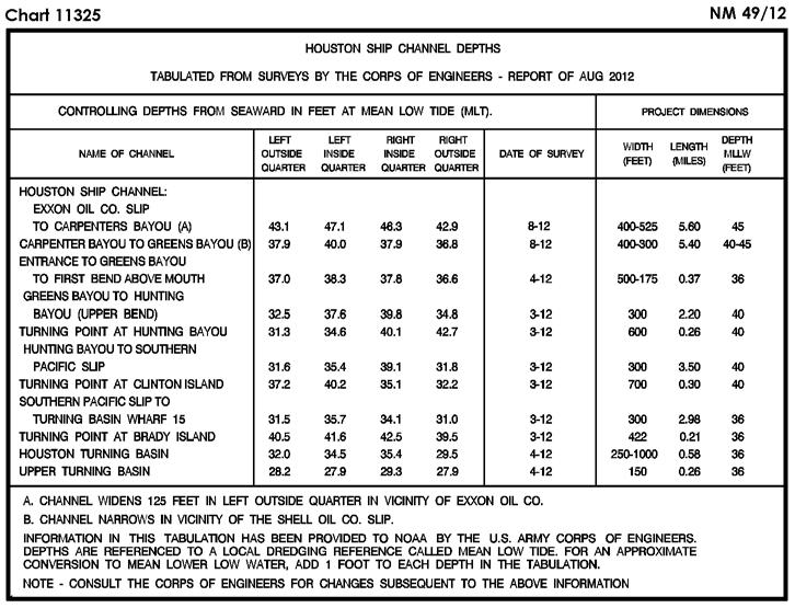
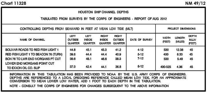
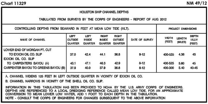
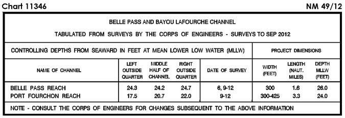
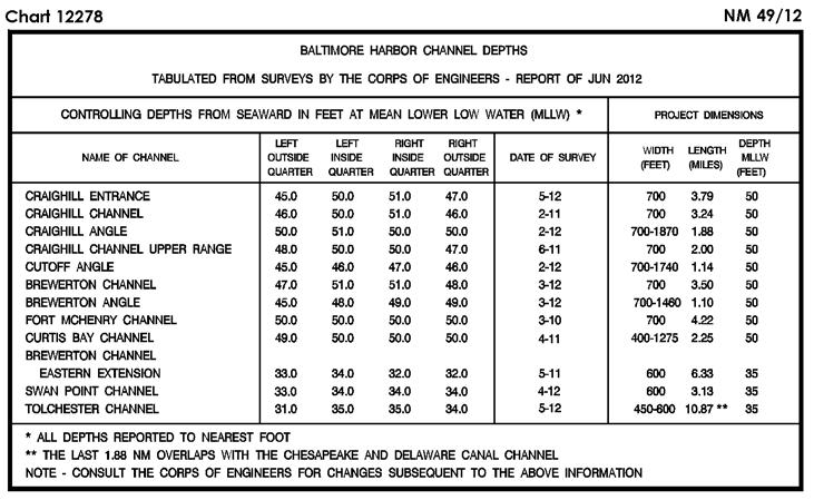
5 SECTION I NM CHART CORRECTIONS 506 (INT 506) 2Ed. 2/3/96 LAST NM 14/12 Add Depth 927 meters enclosed by depth contour (1000-meter) centered 3 34 N E (NTM0005/2012) 1116A Ed. 5/12 LAST NM 42/12 Delete Submerged well (cov 27fms) and buoy N W Platform N W Platform N W Platform N W Danger circles (2) Obstns (PA) in vicinity N W Ed. 8/11 LAST NM 42/12 Add Tabulation of controlling depths from Subsection I-2 (Supersedes 37/ ) (NOS) Ed. 5/08 LAST NM 35/12 Add Tabulation of controlling depths from Subsection I-2 (Supersedes 26/ ) (NOS) Ed. 2/11 LAST NM 42/12 Delete Submerged well (cov 162ft) and buoy N W Add Platform [L10] with legend Unmarked (PA) N W Platform [L10] N W Add Platform [L10] with legend Unmarked (PA) N W (46/12 CG8) Submerged well (cov 20fms) [L20] marked by buoy W Or Fl 2.5s (Priv) N W Submarine pipeline [L40.1] joining N W N W N W N W N W N W N W N W N W (NOS; 45, 46/12 CG8) Ed. 2/10 LAST NM 41/12 Add Platform [L10] N W Platform [L10] N W (Inset) Add Tabulation of controlling depths from Subsection I-2 (See 40/ ) (NOS; 46/12 CG8) Ed. 5/12 LAST NM 42/12 Delete Submerged well (cov 27fms) and buoy N W 1117A Ed. 9/11 LAST NM 42/12 Change Light to Fl R 4M, Q 4M N W (45/12 CG8) Platform Platform Platform N W N W N W Ed. 4/11 LAST NM 45/12 Substitute Depth 14 fathoms Wk [K26] for swept depth 10 fathoms Wk N W Depth 15 fathoms Wk [K26] with legend Unexploded ordnance (2010) for 16 fathoms Wk N W Add Danger circles (2) Obstns (PA) in vicinity N W Platform [L10] with legend Unmarked (PA) N W Platform [L10] N W (NOS) Depth 8 fathoms Wk [K26] for 10 fathoms Wk N W Ed. 9/11 LAST NM 42/12 Change Light to Fl R 4M, Q 4M N W (45/12 CG8) Ed. 6/11 LAST NM 42/12 Add Light Q 20ft 4M N W (45/12 CG8) Ed. 9/12 LAST NM 46/12 (Side A) Add Light Q 20ft 4M N W (45/12 CG8) Ed. 8/11 LAST NM 42/12 Add Tabulation of controlling depths from Subsection I-2 (See 37/ ) (NOS) Ed. 5/08 LAST NM 29/12 Add Tabulation of controlling depths from Subsection I-2 (Supersedes 26/ ) (NOS) Ed. 8/11 LAST NM 42/12 Add Tabulation of controlling depths from Subsection I-2 (See 37/ ) (NOS) Submerged well (cov 20fms) [L20] marked by buoy W Or Fl 2.5s (Priv) N W Submarine pipeline [L40.1] joining N W N W N W N W N W N W N W N W N W (NOS; 45, 46/12 CG8) Ed. 4/11 LAST NM 37/12 Add Platform [L10] N W (46/12 CG8) Ed. 12/10 LAST NM 37/12 Add Platform [L10] N W (46/12 CG8) Ed. 2/12 LAST NM 41/12 Add Platform [L10] N W Platform [L10] N W Tabulation of controlling depths from Subsection I-2 (Supersedes 40/ ) (NOS; 46/12 CG8) Ed. 5/12 LAST NM 35/12 Add Tabulation of controlling depths from Subsection I-2 (Supersedes 35/ ) (NOS) I-1.1
6 NM SECTION I Ed. 7/11 LAST NM 40/12 (Side A) Add Platform [L10] N W Tabulation of controlling depths from Subsection I-2 (See 40/ ) (Side B, Inset) Add Tabulation of controlling depths from Subsection I-2 (NOS; 46/12 CG8) Ed. 8/12 LAST NM 44/12 Delete Platform N W Add Stranded wreck [K24] (PA) N W Submarine pipeline [L40.1] joining N W N W N W (NOS; 45/12 CG8) Ed. 3/12 LAST NM 34/12 Delete Platform N W Platform N W Platform N W Add Platform [L10] N W (45, 46/12 CG8) Ed. 7/11 LAST NM 35/12 Add Submarine pipeline [L40.1] between N W N W (Extension) Change Legend to 21 FT CENTERLINE SEP N W (NOS) Ed. 6/12 LAST NM 42/12 Delete Platform N W Platform N W Danger circle Obstn N W Danger circle Obstn N W Danger circle Obstn (Exposed pipeline) N W Add Platform [L10] N W Note: Platform close W remains (NOS; 45, 46/12 CG8) Ed. 5/12 LAST NM 42/12 Delete Submerged well (cov 85ft) N W Add Platform [L10] N W Note: Platform close W remains Submarine pipeline [L40.1] joining N W N W N W N W (NOS; 46/12 CG8) Change Add (40, 41/12 CG8) Visibility (range) of light 42 to 4M N W Danger circle Obstn [K40] (PA) N W Ed. 8/12 LAST NM 44/12 Add Depth 7 fathoms Obstn [K41] N W (NOS) Ed. 8/12 LAST NM 44/12 Add Depth 42 feet Obstn [K41] N W (NOS) Ed. 9/12 LAST NM 47/12 Relocate Buoy 3 from N W to N W (46/12 CG8) Ed. 12/10 LAST NM 39/12 Relocate Buoy 3 from N W to N W (46/12 CG8) Ed. 6/11 LAST NM 34/12 Add Position circle Pipe [L23] (PA) N W (41/12 CG8) Ed. 8/07 LAST NM 17/12 (Side A) Add Position circle Pipe [L23] (PA) N W (41/12 CG8) Ed. 12/05 LAST NM 17/12 Add Position circle Pipe [L23] (PA) N W (41/12 CG8) Ed. 10/10 LAST NM 38/12 Substitute Depth 14 fathoms Wk [K26] for swept depth 10 fathoms Wk N W Depth 15 fathoms Wk [K26] with legend Unexploded ordnance (2010) for 16 fathoms Wk N W Depth 8 fathoms Wk [K26] for 10 fathoms Wk N W Depth 8 fathoms Wk [K26] for 8 1 / 4 fathoms Wk N W (NOS) Ed. 3/4/06 LAST NM N38/12 N Substitute Depth 25.6 meters Wk [K26] for swept depth 18.3 meters Wk N W Depth 27.4 meters Wk [K26] with legend Unexploded ordnance (2010) for swept depth 26.6 meters Wk N W Ed. 8/11 LAST NM 38/12 Add Danger circle Obstn [K40] (PA) N W (41/12 CG8) (NOS) Depth 14.6 meters Wk [K26] for 18.3 meters Wk N W Depth 14.6 meters Wk [K26] for 14.9 meters Wk N W Ed. 7/11 LAST NM 38/12 Add Submarine pipeline [L40.1] between N W N W (NOS) Ed. 1/12 LAST NM 30/12 Relocate Light 61 from N W to N W (See 14/ ) I Ed. 3/10 LAST NM 45/12 (Side A, Beaufort Inlet II to HH) Delete Beacon N W Relocate Buoy 11 from N W to N W (44, 46/12 CG5)
7 SECTION I NM Ed. 6/05 LAST NM 46/11 Substitute Depth 49 feet Wk [K26] for 50 feet Wk N W Depth 51 feet Wk [K26] for 60 feet Wk N W (NOS) Ed. 1/12 LAST NM 10/12 Delete Beacon N W (44/12 CG5) Ed. 9/11 LAST NM 45/12 Delete Beacon N W Relocate Buoy 11 from N W to N W (44, 46/12 CG5) Ed. 1/05 LAST NM 25/12 Add Depth 20 feet Obstn N W (NOS) Ed. 9/11 LAST NM 46/12 (Page A) Delete BELL from buoy N W (45/12 CG1) Ed. 10/11 LAST NM 44/12 Delete BELL from buoy N W BELL from buoy N W Relocate Buoy 7 from N W to N W (45/12 CG1) Ed. 9/11 LAST NM 45/12 Delete Beacon N W Relocate Buoy 11 from N W to N W (44, 46/12 CG5) Ed. 1/12 LAST NM 37/12 Add Tabulation of controlling depths from Subsection I-2 (Supersedes 33/ ) (NOS) Ed. 7/11 LAST NM 37/12 Add Tabulation of controlling depths from Subsection I-2 (Supersedes 33/ ) (NOS) Ed. 5/11 LAST NM 22/12 Delete Light N W Add Buoy 42 R, Fl R 4s N W (46/12 CG5) Ed. 5/12 LAST NM 27/12 Delete Light N W Add Buoy 42 R, Fl R 4s N W (46/12 CG5) Ed. 3/12 LAST NM 41/12 (Side A) Delete BELL from buoy N W BELL from buoy N W (45/12 CG1) Ed. 4/09 LAST NM 41/12 Delete BELL from buoy N W Relocate Buoy 7 from N W to N W (45/12 CG1) Ed. 4/12 LAST NM 47/12 Delete BELL from buoy N W Relocate Buoy 7 from N W to N W (45/12 CG1) Ed. 6/08 LAST NM 25/12 Add Depth 20 feet Obstn [K41] N W Danger circle Obstn rep (2012) [K40] (PA) N W (NOS) Ed. 6/12 LAST NM 44/12 Relocate Buoy 7 from N W to N W (45/12 CG1) Ed. 12/10 LAST NM 43/12 Delete BELL from buoy N W (45/12 CG1) Ed. 3/11 LAST NM 25/12 Delete BELL from buoy N W (45/12 CG1) Ed. 6/10 LAST NM 31/12 Delete BELL from buoy N W (45/12 CG1) Ed. 8/12 LAST NM 39/12 Delete Coast guard station symbol and legend CG N W (NOS) Ed. 2/19/05 LAST NM N36/12 N Delete Coast guard station symbol and legend CG N W (NOS) Ed. 8/04 LAST NM 28/12 Delete Coast guard station symbol and legend CG N W (NOS) Ed. 12/09 LAST NM 48/12 Add Green anchor berth circle C1 [N11.1] N W Green anchor berth circle C2 [N11.1] N W Green anchor berth circle C3 [N11.1] N W Green anchor berth circle C4 [N11.1] N W Green anchor berth circle C5 [N11.1] N W Green anchor berth circle C6 [N11.1] N W Green anchor berth circle C7 [N11.1] N W Green anchor berth circle E1 [N11.1] N W Green anchor berth circle E2 [N11.1] N W Green anchor berth circle E3 [N11.1] N W Green anchor berth circle E4 [N11.1] N W Green anchor berth circle E5 [N11.1] N W Green anchor berth circle E6 [N11.1] N W (continued on next page) I-1.3
8 NM SECTION I (Continued) Green anchor berth circle E7 [N11.1] N W Green anchor berth circle W1 [N11.1] N W Green anchor berth circle W2 [N11.1] N W Green anchor berth circle W3 [N11.1] N W Green anchor berth circle W4 [N11.1] N W Green anchor berth circle W5 [N11.1] N W Green anchor berth circle W6 [N11.1] N W Green anchor berth circle W7 [N11.1] N W (NOS) Ed. 9/09 LAST NM 48/12 Add Green anchor berth circle C1 [N11.1] N W Green anchor berth circle C2 [N11.1] N W Green anchor berth circle C3 [N11.1] N W Green anchor berth circle C4 [N11.1] N W Green anchor berth circle C5 [N11.1] N W Green anchor berth circle C6 [N11.1] N W Green anchor berth circle C7 [N11.1] N W Green anchor berth circle E1 [N11.1] N W Green anchor berth circle E2 [N11.1] N W Green anchor berth circle E3 [N11.1] N W Green anchor berth circle E4 [N11.1] N W Green anchor berth circle E5 [N11.1] N W Green anchor berth circle E6 [N11.1] N W Green anchor berth circle E7 [N11.1] N W Green anchor berth circle W1 [N11.1] N W Green anchor berth circle W2 [N11.1] N W Green anchor berth circle W3 [N11.1] N W Green anchor berth circle W4 [N11.1] N W Green anchor berth circle W5 [N11.1] N W Green anchor berth circle W6 [N11.1] N W Green anchor berth circle W7 [N11.1] N W (NOS) Ed. 4/06 LAST NM 47/12 Add Green anchor berth circle C5 [N11.1] N W Green anchor berth circle C6 [N11.1] N W Green anchor berth circle C7 [N11.1] N W Green anchor berth circle C8 [N11.1] N W Green anchor berth circle E5 [N11.1] N W Green anchor berth circle E6 [N11.1] N W Green anchor berth circle E7 [N11.1] N W Green anchor berth circle E8 [N11.1] N W Green anchor berth circle W5 [N11.1] N W Green anchor berth circle W6 [N11.1] N W Green anchor berth circle W7 [N11.1] N W (NOS) Green anchor berth circle W8 [N11.1] N W Ed. 2/11 LAST NM 48/12 (Page A) Add Green anchor berth circle C1 [N11.1] N W Green anchor berth circle C2 [N11.1] N W Green anchor berth circle C3 [N11.1] N W Green anchor berth circle C4 [N11.1] N W Green anchor berth circle C5 [N11.1] N W Green anchor berth circle C6 [N11.1] N W Green anchor berth circle C7 [N11.1] N W Green anchor berth circle C8 [N11.1] N W Green anchor berth circle E1 [N11.1] N W Green anchor berth circle E2 [N11.1] N W Green anchor berth circle E3 [N11.1] N W Green anchor berth circle E4 [N11.1] N W Green anchor berth circle E5 [N11.1] N W Green anchor berth circle E6 [N11.1] N W Green anchor berth circle E7 [N11.1] N W Green anchor berth circle E8 [N11.1] N W Green anchor berth circle W1 [N11.1] N W Green anchor berth circle W2 [N11.1] N W Green anchor berth circle W3 [N11.1] N W Green anchor berth circle W4 [N11.1] N W Green anchor berth circle W5 [N11.1] N W Green anchor berth circle W6 [N11.1] N W Green anchor berth circle W7 [N11.1] N W Green anchor berth circle W8 [N11.1] N W (NOS) Ed. 4/11/98 LAST NM 37/12 Change Visibility (range) of light to 5M S W (11(140)12 Buenos Aires) Ed. 2/15/97 LAST NM 37/12 Change Light to Fl(3) R 9s 9m 5M S W (Plan) Change Light to Fl(3) R 9s 9m 5M S W (11(140)12 Buenos Aires) Ed. 10/17/98 LAST NM 37/12 Change Light to Fl(3) R 9s 9m 5M S W (11(140)12 Buenos Aires) Ed. 9/27/97 LAST NM 36/12 Add Foul ground symbol [K31] S W (8(94)12 Buenos Aires) Ed. 11/22/97 LAST NM 41/12 Add Foul ground symbol [K31] S W (8(94)12 Buenos Aires) Ed. 7/12/97 LAST NM 25/12 Add Foul ground symbol [K31] S W (8(95)12 Buenos Aires) I-1.4
9 SECTION I NM Ed. 8/9/97 LAST NM 36/12 Add Foul ground symbol [K31] S W (8(94)12 Buenos Aires) Ed. 6/28/97 LAST NM 18/11 Add Dangerous wreck [K28] (PA) N E (UKHO ARCS ) Ed. 4/30/11 LAST NM N48/12 N Add Foul ground symbol [K31] S W (11(139)12 Buenos Aires) Ed. 6/22/96 LAST NM 22/08 Add Dangerous wreck [K28] (PA) N E (UKHO ARCS ) Ed. 10/4/97 LAST NM 48/12 Add Foul ground symbol [K31] S W (11(139)12 Buenos Aires) Ed. 3/8/08 LAST NM 17/08 Add Dangerous wreck [K28] (PA) N E (UKHO ARCS ) Ed. 9/18/10 LAST NM N48/12 N Add Dangerous wreck [K28] (PA) S W (11(138)12 Buenos Aires) Ed. 6/10/95 LAST NM 25/12 Relocate Pilot station symbol from N W to N W (40(4479)12 Taunton) Ed. 6/10/95 LAST NM 13/12 Relocate Pilot station symbol from N W to N W (40(4479)12 Taunton) Ed. 8/28/10 LAST NM N3/12 N (Plan A) Change Characteristic of light to Fl(2) 15s N W (See N3/ ) (134/12 Bogota) Ed. 8/9/97 LAST NM 47/12 Delete Superbuoy ODAS N W (1(105)12 Lisboa) Ed. 9/12/98 LAST NM 8/12 Delete Superbuoy ODAS N W (1(105)12 Lisboa) Ed. 9/26/98 LAST NM 49/09 Add Foul ground symbol [K31] N W (11(381)11 Kobenhavn) Ed. 1/00 LAST NM N12/05 N Add Foul ground symbol [K31] N W (11(381)11 Kobenhavn) Ed. 5/1/10 LAST NM 14/11 Add Foul ground symbol [K31] N E (8(804)11 St. Petersburg) Ed. 2/2/08 LAST NM 47/12 Add Foul ground symbol [K31] N E Foul ground symbol [K31] N E (8(804, 805)11 St. Petersburg) Ed. 12/18/93 LAST NM 8/12 Delete Superbuoy ODAS N W (1(105)12 Lisboa) Ed. 2/1/03 LAST NM 47/12 Substitute Depth 35 meters Wk [K26] for 33 meters Wk N E Add Depth 58 meters Wk [K26] N E Depth 27 meters Obstn [K41] N E (NTM0002/2012) Ed. 2/1/03 LAST NM N47/12 N Substitute Depth 35 meters Wk [K26] for 33 meters Wk N E Add Depth 58 meters Wk [K26] N E Depth 27 meters Obstn [K41] N E (NTM0002/2012) Ed. 3/1/03 LAST NM 47/12 Substitute Depth 35 meters Wk [K26] for 33 meters Wk N E Add Depth 58 meters Wk [K26] N E Depth 27 meters Obstn [K41] N E (NTM0002/2012) Ed. 3/15/03 LAST NM 43/12 Substitute Depth 35 meters Wk [K26] for 33 meters Wk N E Depth 58 meters Wk [K26] for 54 meters Wk N E Add Depth 27 meters Obstn [K41] N E (NTM0002/2012) Ed. 3/15/03 LAST NM N43/12 N Substitute Depth 35 meters Wk [K26] for 33 meters Wk N E Depth 58 meters Wk [K26] for 54 meters Wk N E Add Depth 27 meters Obstn [K41] N E (NTM0002/2012) Ed. 9/20/08 LAST NM 35/12 Delete Buoy and legend Rep (2012) N E Buoy and legend Rep (2012) N E (See 14/ ) (27(2891)12 Taunton) Ed. 9/20/08 LAST NM N35/12 N Delete Buoy and legend Rep (2012) N E Buoy and legend Rep (2012) N E (See N14/ ) (27(2891)12 Taunton) Ed. 6/4/94 LAST NM 41/12 Add Buoy ODAS [Q58] Y, spherical, Fl(5) Y 20s N W (10(325)11 Lisboa) Ed. 3/23/96 LAST NM 33/12 Add Depth 28 meters S E Depth 27 meters S E (NTM0005/2012) Ed. 10/23/04 LAST NM 31/12 (Panel A) Add Depth 29 meters enclosed by depth contour (50-meter) centered N E (UKHO ARCS ) Ed. 2/3/96 LAST NM 33/12 Add Depth 34.5 meters S E Depth 28.2 meters enclosed by depth contour (30-meter) centered S E (continued on next page) I-1.5
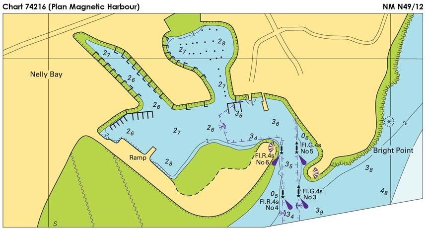
10 NM SECTION I (Continued) Depth 20.9 meters S E and extend depth contour (30-meter) E to enclose Depth 27.2 meters enclosed by depth contour (30-meter) centered S E Depth 39 meters S E (NTM0005/2012) Ed. 5/27/05 LAST NM N51/11 N Delete Buoy S E Solid line and legend Jetty between S E S E Ed. 6/21/97 LAST NM 52/10 Substitute Depth 421 meters for 561 meters S E (NTM0005/2012) Ed. 3/3/90 LAST NM 46/08 Add Depth 1557 meters N E (NTM0005/2012) Ed. 6/15/96 LAST NM 44/12 Change Visibility (range) of light to 15M N E (3(49)12 Manila) Ed. 7/18/92 LAST NM 39/12 Add Wreck [K29] N E (142/12 Tso-ying) Relocate Beacon S S E Beacon S2 from S E to S E Ed. 9/2/95 LAST NM 37/12 Add Wreck [K29] N E (142/12 Tso-ying) Beacon from S E to S E Substitute Foul ground symbol [K31] for depth 0.9 meter S E Ed. 7/22/95 LAST NM 47/11 Add Wreck [K29] N E (142/12 Tso-ying) Add Chartlet A, depicting changes in Zone of Confidence Diagram and Categories, from Subsection I S E Chartlet B, depicting changes in topography and aids to navigation, from Subsection I S E Note from Subsection I S E Ed. 3/3/12 LAST NM N27/12 N Add Light Fl 10s 32m N E (3(28)12 Manila) Ed. 4/2/11 LAST NM N8/12 N Add Light Fl 10s 32m N E (3(28)12 Manila) Buoy G, conical, Fl G 2.5s Danger line [K1] joining S E S E S E S E Ed. 1/22/83 LAST NM 44/12 Change Visibility (range) of light to 15M N E Add Height 39ft to light N E (3(48, 49)12 Manila) (Plan Magnetic Harbour) Add Chartlet, depicting changes in hydrography, topography and aids to navigation, from Subsection I S E (15(741), 16(792)06, 2(90), 9(433), 12(575)08, 5(292), 8(473)09, 11(545), 13(632)11, 17(840)12 Wollongong) Ed. 8/26/95 LAST NM 48/10 Relocate Light from S E to S E (11(545)11 Wollongong) Ed. 6/10/78 LAST NM 14/12 Change Visibility (range) of light to 15M N E Height of light to 39ft (3(48, 49)12 Manila) N E Ed. 7/23/11 LAST NM 43/12 Add Wreck [K29] N E (142/12 Tso-ying) Ed. 11/21/08 LAST NM N10/12 N Delete Purple composite line and legend Townsville Port Security Limit joining S E S E S E S E Beacon S E Beacon S E Add Chartlet, depicting changes in hydrography, topography and aids to navigation, from Subsection I S E Townsville Port Security Limit area [N2.1] bound by shore and purple composite line joining S E S E S E S E S E S E (24(1239)11, 16(781), 17(840)12 Wollongong) Ed. 7/22/95 LAST NM 12/11 Relocate Light from S E to S E (11(545)11 Wollongong) Ed. 6/30/07 LAST NM 43/12 Add Buoy ODAS [Q58] Or, conical, Fl R 4s N E (146/12 Tso-ying) Ed. 9/26/09 LAST NM 37/12 Add Wreck [K29] N E Buoy ODAS [Q58] Y, conical, Al RY 7s N E (142, 1 Tso-ying) Ed. 5/27/06 LAST NM 37/11 Add Buoy ODAS [Q58] Y, conical, Al RY 7s N E (1 Tso-ying) Ed. 2/4/89 LAST NM 18/11 Add Depth 378 meters N E (NTM0005/2012) Ed. 7/19/86 LAST NM 19/11 Add Depth 378 meters N E (NTM0005/2012) I-1.6

11 SECTION I NM I-2.1

12 SECTION I NM I-2.2

13 SECTION I NM I-2.3

14 SECTION I NM I-2.4

15 SECTION I NM I-2.5

16 SECTION I NM I-2.6

17 SECTION I NM I-2.7

18 SECTION I NM I-2.8
19 SECTION I NM CHARTS AFFECTED BY NOTICE TO MARINERS NM 52/11 THROUGH NM Note: N indicates Not For Sale; P indicates Preliminary; T indicates Temporary; * indicates New Edition/New Chart; ** indicates Chart Canceled Chart Ed. Notice to Mariners / / / / ,44/ / / / / / / / / / ,30/ ,20,25,26,32,34/ ,26/ ,25/ ,8,13/ / / ,35,48/ ,48/ ,30/ ,10,14,17,35,38,48/ / /11;3,7,10,27,38/ / / / ,14, / / / / ,42,44/ / / ,12/ ,14/ ,12,29/ ,20,27,34,38,42,44/ ,13,35,37,42,43/ ,44/ / / / ,27/ / / ,27/ ,29,40/ ,29/ / ,31/ / ,26/ / N38/12* 1113A 6,34,38,48/ A 23,35,37/ A 8,9,11,13,16,18,20,23,26, 27,29,30,34,35,38,39, 42/ A 29*,30,31,32,34,35,37, 38,40,41,42, 1117A 52,53/11;8,9,12,16,22,27, 34,42, /11;7,8,9,11,17,18,20, 21,22,26,30,32,38,42/ ,18,23,26,27,29,31,35, 38,39,42/ ,26,45, *,35,38/ N36/ ,53/11;8,9,12,16,22,27, 34,42, ,36/ ,36/ /12* N3,N22,N26,N36/ / ,36/ *,26,34,36/ N22,N26,N36/ ,26,36/ ,22,26,34,36/12 Chart Ed. Notice to Mariners ,19,36,42, ,36/ N3,N22,N26,N36/ *, N34/ ,32,37/ *,37/ *,26,27,29,37,42/ ,9,13,16,22,26,27,29,32, 34,37,42, ,9,13,16,26,29, *,11,16,17,18,27,29,34, 35,37,41,42/ ,11,13,16,26,27,29,30, 32,37,41,42, ,9,11,13,16,17,18,26,27, 29,32,37,42, ,9,13,16,17,18,26,29,34, 35, ,53/11;6,9,11,16,20,22, 26,30,34,35,41,42, ,41/ *,17,19,20,27,35,37/ ,9,11,14,19,23,27,34,35, 40,41, *,30,31,32,34,35,37, 38,40,41,42, ,12,13,14,17,19,20,26, 34,35,37, ,12,13,17,22,23,26,29, 34,37, ,22,26,32,34,37,41/ *,19,23,26,27,29,30, 34,35,40,41, *,30/ *,30,34,35, ,9,11,14,19,23,27,34,35, 40, ,19,30,40/ *, /12* *,21,34, /12* /11;11,14,19,21,26,30, 35, /12* *,34,37,38,40,42, *,34,35,37,40,41,42, *,42/ ,18,21,34,42/ ,9,11,13,16,18,20,23,26, 27,29,30,34,35,38,39, 42/ ,53/11;1,11,13,14,16, 18,34,38, N8,N9,N11,N13,N16, N18,N20,N23,N26,N27, N29,N30,N34,N35,N38, N39,N42/ /11;11,14,19,21,26,30, 35,38, *,14,19,20,26,27,30, ,31/ *, /11;18,20,22,23,26/ *,18,20,22,23/ /12* *,12,16,20,23,26,27, 34,35,37,42/ /12* /12* *, *,16,17,22,26,28,42/ *,16,17,22,26,28,42/ /11;1,13,16,21,22,27, 31,34,37/ /11;1,13,16,21,27/ ,3,12,13,16,19,27,28,29, 32,34,35,39/ /11;13,21,27/ ,19,23,28,29,34,35, 39/ *, ,12,19,28,32,34,35,39, Chart I-3.1 Ed. Notice to Mariners / /12* ,34, , , ,34/ ,35,37/ / / ,37/ *,19,36,42/ *,40,46/ *,40,41,46/ *,15,19,40,46/ ,34,38,48/ N6,N38/ *,42/ ,5,11,37,41,42,43,48/ ,37/ ,37/ ,6,34,38,48/ N5,N6,N35,N38/ ,6,17,34,38,48/ ,17,18,36,42/ ,34,45/ /12* ,36,42/ ,18,42/ / ,9,18,35,36,37,45,48/ / ,45/ *,46/ ,39/ /11*;9,36,37,48/ ,18,27,36/ ,36,37,48/ / ,19,36,39,45/ *,11,19,21,34,36/ / ,19,21/ N10,N19/ ,22,23,39,46/ N10/ / ,39/ N23,N39/ ,39/ N46/ ,10,11,13,42,48/ ,39/ N10,N19/ ,9,41/ /12* /11;9,12,20,30,41, 47/ ,30/ /12* / N38,N42/ N52/11;N20,N36,N38, N42,N45,N48/ N3,N6,N10,N11,N12, N13,N48/ ,12,13,35,42,47/ *,20,36,38,42,45,47/ ,35,41/ ,10,29,31,34,39,42, 47/ *,39,41,42,47/ /11;3,9,17,20,23,29,34, 42,43/ *,17,18,20,34,35,48/ /11;13,34,42/ ,20,29/ ,4,9,10,13,14,17,18,21, 23,29,31,34,35,39,42,43, 45,47/ /11;3,6,12,44/ ,10,13,14,21,23,29,34, 39,42,47/ /11;6,9,14/ ,9,12,44/ *,44/ ,5,10,12,15,26,34,38, Chart Ed. Notice to Mariners ,12,15,34/ / /11;29,34,44/ *,12,14,15,20,29,34/ N5,N10,N26,N38, N *,29/ /12* /11;9,10,12,17,21, 35/ *,17,21,34,35/ *,34/ ,10,15,26,34/ ,11,33,34/ / ,45, / *, ,33,45, ,33,37,45, /12* /12* *,26/ ,5,10,11,15,24,26,27,38, 45/ N1,N5,N10,N11,N15, N27,N38,N45/ ,24/ *,45/ ,35,36/ ,45/ *,11,45/ ,45/ ,34/ ,15,22/ /12* ,8,10,11,22,24,26,27,35, 45/ ,11,22,26,34,35,36,37, 45/ ,8,11,22,27,35/ *,25,26,27,33,37,45/ ,33/ ,26,27,33,45/ ,7,11,25,26,27,33/ ,26,27/ ,33/ ,33,37/ ,33/ ,24,45/ ,8,24/ ,15/ / ,15,33,34,35,37,38, 42/ ,10,15,35,38/ ,24,45/ / *,34,36/ ,7,11,26/ ,7/ /11*;11/ *,38/ ,10,11,25/ ,26,34/ ,38/ ,25,34/ *,25,26,33,37, /12* / ,22,25,26,33,37, *,11,25,26,27,33,34,35, 37,38,45/ *,33,35/ *,33,37,38/ *,38/ ,25/ ,25,27,33,34/ / / / *,41/ N14,N29,N31,N33,N34, N38,N41/ ,22, *,
20 NM SECTION I CHARTS AFFECTED BY NOTICE TO MARINERS NM 52/11 THROUGH NM Note: N indicates Not For Sale; P indicates Preliminary; T indicates Temporary; * indicates New Edition/New Chart; ** indicates Chart Canceled Chart Ed. Notice to Mariners *,34/ *,26,33,34/ *,34/ ,15,24,26/ ,24,26/ ,38/ / *,26,27,30,41, ,41/ ,22,27,29,30,31,41, *,26,30,31,33,36,39, 41,44,47, ,10,15,36,44,47/ ,10,15,36,44/ /11;1,9,10,15,17,21,26, 29,39,41/ ,9,21,30,33/ *,30,36/ / ,25, ,36/ , / / ,45/ ,30,46/ *,45/ *,45/ *,30,31,34,39,43,46/ ,11,25,27,30,31,39/ ,30,45/ ,20,25,30,34,37,44/ *,44,45,47/ /12* ,31,47/ / ,23,25,30/ ,20,25/ /12* /12* ,3,7,10,25,28,31,39,42, 46, ,46/ / / /12* /12* ,26,44, *,44, N1,N12/ /12* *,39,41/ ,7,12,18,23,34,36,39/ /12* N12,N18,N31,N34, N36/ / ,9,10,19,25,31,40,43, ,25,43/ , ,25,31, ,7,10,25,28,42/ ,25/ ,9,19,40/ ,8,9,19,24,26,27,33,34, 40,41/ *,9,40/ *,23,24,26,29,41/ *,19,24,31,36/ ,26,29,36/ / ,26,36/ / ,15,19,20,27,31,33,34, 40/ ,40/ / ,31,44/ /12* /12* ,12,18,19,20,26,27,31, 33,40,41,44/ ,31/ /12* *,15/12 Chart Ed. Notice to Mariners *,12,18,26,27,41/ ,18,26,31,37,39/ / ,28,39/ ,37/ *,39, N1,N7,N12,N23,N36, N ,36/ / *,26/ ,33/ ,33/ / / / / ,33/ / / /12* / *,13,36,39,43/ ,39/ *,43/ /12* *,13,43/ / / /12* / /12* / ,17,27,28, ,17,28/ ,18,20,27/ ,18,20,27/ ,12,41/ N35/12* N35/12* N36/12* N38/12* N38/12* N38/12* N35/12* N35/12* ,23/ ,23/ / ,23/ / / / N39/12* / / ,23/ / / / ,7,39/ / / / ,16/ / ,16/ / / / / / / ,39/ / ,39/ ,20,26,35,36,46/ / ,33,36/ ,20,26,30,33,35,36, 46/ ,35/ /11;34,39/ ,2,16,33,34,39/ / ,20,22,23,27,33/ ,34/12 Chart I-3.2 Ed. Notice to Mariners / / /11;31,39/ /11;2,31,33,39/ / ,15,19,26,35,39,42/ ,16,26,33,39/ / ,35,46/ ,19,20,28,39,42,45/ / ,30/ / / / / ,35/ / / /12* / ,39/ ,42/ ,47/ /11;11,15,19,20,21,28, 39,42/ ,19/ / /11;15,21/ / / / ,48/ ,33,39/ / ,33/ / / / ,28,39/ ,36,42,45/ N9/ N9/ N20/ N19/ N13/ N14/ N20/ N20/ N35/12* N15/ N12/ N24/ N7/ N7,N19/ N19/ N19/ N11,N19/ N11/ N13/ N9,N13/ N12,N19/ N12/ N12/ N12/ N7,N19/ ,44/ ,44/ / *,40/ ,37,39,45/ /12* / /12* ,47/ / ,39,40/ /12* /12* / ,40/ / / / / ,4,46,48/ /12* Chart Ed. Notice to Mariners / ,4,46,48/ / / / / / ,45/ *,25,35,45/ *,29/ *,25,35,45/ / *,39,47/ / *,39/ *,26,28,39,47/ *,19,26,28,47/ *,39/ / / / / /12* ,31/ ,43/ ,28/ N11,N20/ ,39/ / /12* ,48/ ,48/ / /12* /12* / /12* /12* /12* /12* *,31/ ,45/ / /12* ,39/ / / /12* /12* /11;8,9/ / /11;8,9,39/ / N20/ N11/ N11/ / / ,39/ / N39/ / N11/ N11/ N11,N13/ ,8/ N8/ N11/ N7,N11/ N8,N11/ N9/ N9/ N9/ N44/ N11,N13,N19,N24, N31/ N13/ N36,N39/ N3,N13,N15,N28, N39/ N13,N20/ N29/12* /11;10,11,17,38/ N52/11;N10,N17,N38/ ,5,7,13,20,28,34,40, 43/ N2,N10,N17,N37/12
21 SECTION I NM CHARTS AFFECTED BY NOTICE TO MARINERS NM 52/11 THROUGH NM Note: N indicates Not For Sale; P indicates Preliminary; T indicates Temporary; * indicates New Edition/New Chart; ** indicates Chart Canceled Chart Ed. Notice to Mariners N7,N17/ ,7,13,20,27,34,37,43/ N3,N7,N20,N27,N34, N37,N43/ N2,N10,N16,N37/ /12* *,17,37,38/ /11;2,10,11,17,20,37, 38,43/ *,28,33,37,44,45/ N13/ / ,6,15,17,18,19,22,23,33, 37,45,48/ /11*;4,5,6,8,10,12,15, 16,17,18,19,22,23,31,33, 37,48/ ,22,31/ ,17,18/ ,23/ ,17,18,33,37/ ,18,19/ ,18/ ,15,18/ ,19/ ,19,22/ N36/12* N9/ N9/ ,4,8,10,15,16,18,19,22, 43/ ,8,9,10,12,15,16,18,19, 22,23,24,25,27/ ,10,16,18,19,22,23/ ,15,18,19,22/ *,26,27,31/ ,16,18,31/ /12* /12* ,4,8,10,16,18,19,22,24, 25,27/ ,4,8,18,22,24,25,27/ N13,N19/ ,19,22/ ,19,22/ N15/ N15/ ,28/ / ,22/ N15/ ,5,18,20,28/ N9,N15,N19/ N10,N31,N48/ ,18,22/ ,8,13,15,20,22,23,37,43, 45,48/ N10,N11,N14/ N13,N19/ /12* ,12,22/ ,8,9,11,16,19,22,27/ ,4,8,10,11,17,18,19,22, 24,25/ ,11,19,22,27/ ,19,27/ ,3,5,13,15,19,22,28,40, 43/ ,22/ ,22/ ,20,43/ ,11,15,24,40,48/ ,48/ ,9,10,18,22,26,28,30,45, 48/ ,26,27,28,30,48/ ,15,26,27,28,30,48/ *,40,48/ *,37,48/ *,48/ ,30,31,34,44/ *,48/ ,15,28,35,48/ /12* /12* *,33,34,42,45,48/ ,20,34,48/12 Chart Ed. Notice to Mariners ,17,18,33,42,44,45, 48/ ,33,45/ ,20,34,45,48/ ,21,31,37,42,43/ ,33,48/ ,44/ *,26/ ,44/ *,27/ / /12* /12* ,9,43/ / *,43,45/ ,4,5,8,9,14,19,24,25,26, 28,34,39,40,43,45,46,48, ,5,8,14,24,26,28,34,39, 40,46,48, ,18,19,34,47, /11;1,4,6,8,14,16,18, 19,24,25,26,36,39,40,44, 45,46,48, ,5,19,24,25,34,46,48/ ,11,19,24/ /11;16,18,25,45,46/ ,45/ ,18,25,45,46/ /11;25/ /11;45/ /11;45/ / ,45/ ,2,9,10,16,37,43/ / /12* ,17/ /11;7,11,17,20,21,36, 38/ ,17,20,21/ / ,38/ ,31,38/ ,36,38/ / N38/ /11;2,11,21,23,30,34, 35,36,38,43/ N52/11;N30,N42/ ,23,43/ ,39/ ,31,39,46/ /12* /11;21/ / N52/11;N7,N11,N17, N23,N30,N38,N43/ / /12* ,30,33,42/ ,42/ N30,N42/ ,33,42/ *,33/ ,21,30,35/ N8,N46/ ,46/ / ,46/ ,46/ ,44,46/ ,20/ ,26,44/ / N5,N8,N11,N46/ ,8,11,26,46/ / ,26,46/ / / ,26/ ,11,26,30,37/ / ,26/ N1/12 Chart I-3.3 Ed. Notice to Mariners / ,26/ /11;26,37/ ,26,30,37/ ,26,30,37/ N8/ ,26/ ,26/ / / / N8/ ,14/ ,17,28/ /11;17,23/ /11;39/ / ,17/ / ,4,5,8,10,11,17,25/ ,4,5,8,10,11,17,19/ ,17,28,48/ / / N2/ / ,10/ N9,N28/ ,33/ ,31/ / ,42/ ,9/ N21/12* /12* / / / /12* ,36/ /12* / ,39/ ,20/ /11;40/ / ,5,8,10,17,25,42,44, 45/ ,26,46,47/ /11;5,26,46,47/ ,47/ /11;5,26,41,46,47/ ,21/ / / / ,21,44/ ,8,20,42/ / / ,8,28,30,42/ ,8,28/ ,8,28,29,30,31,42/ ,20,31/ ,20,31/ ,31/ / / ,23/ ,40/ N36/12* / /11;5,9/ /11;5,9,40/ /11;9,18,23/ /11;5,9,18/ ,42/ /11;33/ ,35,42/ ,42,47/ N3,N28/ / ,47/ ,47/ ,35,47/ / /12 Chart Ed. Notice to Mariners ,8,42/ ,20/ N21*,N36/ ,19/ ,7,8/ / N17*,N42,N47/ /11;4,28/ / /11;3,13,25/ ,36,48/ ,47,48/ ,48/ N36,N47,N48/ N53/ N53/11* N16/12* N10/12* N22/12* N53/11* N16*,N36/ N39/12* /11;36/ N16/12* N53/ N48/ N3/ ,48/ ,7,29/ ,7,29/ /11;37, ,37, /11;37, / N6/ ,19/ N48/ /11;19/ N3/12* / / N38,N39/ / / / / N53/11;N38,N39/ / ,6,10,26,33,34,36/ ,25,32,33,36, / ,26,32,33,34,35,36,41, / N8,N10,N30/ , ,22,34,35/ ,34,35/ / N20,N22,N32,N34/ / N8,N34,N35/ N6,N20,N34,N35/ N6/ ,36/ ,22,32,33,36, ,20,22,26,33/ ,22,26,32,33,34/ / / / / / / ,10,41/ / / ,27,42,48/ ,32,35,36,39,48/ / N5,N20,N27,N35,N36, N48,N N25,N27/ ,35,36,48, N22*,N24,N25,N26, N48/ N5,N22,N48,N
22 NM SECTION I CHARTS AFFECTED BY NOTICE TO MARINERS NM 52/11 THROUGH NM Note: N indicates Not For Sale; P indicates Preliminary; T indicates Temporary; * indicates New Edition/New Chart; ** indicates Chart Canceled Chart Ed. Notice to Mariners / / ,41,48/ ,38/ ,41/ / ,31/ ,20,31,39/ ,13/ / N1,N39/ N39,N41/ / / / / / / / / / N21/12* ,38,42/ N22*,N37/ / / / / / / ,8/ / ,27/ / / ,48/ N14/ / /11;14,19,23,43/ ,19/ ,19/ ,19,43/ / ,15/ / / /11;14/ ,21,40,43/ / ,35/ N25/12* ,40/ ,40/ ,25,43/ ,12,17,20,23,29,30, 45/ ,35,43/ / / ,12,17,20,23,29,36, 41/ ,17,23,29,36,41/ N48/ ,6,7,9,13,17,23,33,41/ ,24,29,33/ ,7,9,10,13,19,33,40, 45/ ,23/ ,26,31/ ,26,31,42/ ,42/ ,14,26,31/ ,14,26,31,32,42/ ,30/ ,17,20,30,40/ / ,20,40/ / /11;21,30/ N20,N23,N24,N30,N41, N47/ ,41/ ,21,24,48/ / / ,24/ /12 Chart Ed. Notice to Mariners N21/12* ,13,25, ,25/ , /11;5,8,13,21,24/ /11;17,23,24,25/ ,25/ / / / /11;23,24,41,47/ / ,24,31/ / / /11;1,41/ ,20,47/ / /12* /12* / *,15/ /12* /12* ,48/ / / ,12,20/ / *,8/ / / / /12* / / ,29,30,41/ / / / / N3,N N48/ N48/ ,19,28/ / / / ,17/ N17/12* / / / / / N20/ / / / ,48/ / ,46/ ,48/ ,41,48/ / / ,35,38,39/ N31,N40/ / / / / ,10,14/ ,19/ / ,15,25/ ,13,19/ ,25/ / / / N3*,N33/ N37*,N45/ / / / /12 Chart I-3.4 Ed. Notice to Mariners ,10/ / / / / /11;14,23,38/ / / /11;9,14,17,23,38, 48/ /11;48/ /11;48/ / N23/ / / ,14,17,38,48/ N23/ N23/ ,17,28,38/ ,10,18,23/ ,23/ / ,38,48/ ,42/ / / ,28/ / / /12* / / /12* ,33,44/ N20/ N1/12* N1/12* N37/12* N31/12* N21/12* N52/ N8,N32/ N42/12* N2/12* N3*,N33/ N5*,N14,N33/ N42/12* N30/12* N44/12* N42/12* N44/12* N52/ N14/ N10,N13,N32/ N8/ N12,N32/ /12* N53/11;N10,N13,N25, N32/ N53/11;N13,N25,N32/ N44/12* N24/12* N13/12* N2/12* N13/12* N32/ N29/12* N45/12* N8,N32/ N32/ N45/12* N45/12* N8/ ,44/ /11;1,9,10,11,15,17,19, 20,22,33/ N5/12* ,9,10,11,15,17,19,20,21, 22,23,26,32,36,45/ N1*,N8/ ,43,47, N3/12* / ,43/ , N5/12* Chart Ed. Notice to Mariners N14,N15,N17,N19,N21, N22,N27,N33,N45/ N23/ N10/ N45/12* /12** N38/12* /12** N34/12* ,35,36,38,40,42,45,47, 48/ N36/ N36/ / N6,N8,N32,N35,N40, N45,N48/ ,36,48/ N1,N2,N8,N13,N15, N17,N19,N22,N23,N26, N33,N35,N39,N45, N47/ N38/12* N5,N8,N26,N39/ ,9,11,12,13,15,16,17,19, 20,22,32,41/ ,11,12,13,14,15,17,19, 21,22,23,26,33,35,39,45, 47,48/ /11;9,15,17,19/ N52/ ,17/ ,12,13,15,16,27,32, 41/ N8,N12,N20,N35,N38, N39,N41/ /12* /11;8,12,22,38,41/ N4,N12,N13,N22/ ,13,15,41/ ,13/ N4*,N13,N16,N22/ N13/ N2,N4,N16/ / ,13/ N2,N13,N20,N23, N32/ N39*,N47/ N53/11*;N2,N13,N32, N38,N47/ / N2,N8,N12,N15,N17, N19,N23,N26,N27,N32, N33,N35,N38,N42,N45, N47,N48/ N29*,N32,N35,N47/ N34*,N35,N45/ N29*,N32,N35,N39, N47,N48/ / ,45/ ,45/ / / ,47/ ,45,47/ / ,8,47/ ,47/ N40/12* ,17/ N16,N17/ ,29/ N32/ N32/ / / / N N41/12* / N52/ / / / N4/12
23 SECTION I NM CHARTS AFFECTED BY NOTICE TO MARINERS NM 52/11 THROUGH NM Note: N indicates Not For Sale; P indicates Preliminary; T indicates Temporary; * indicates New Edition/New Chart; ** indicates Chart Canceled Chart Ed. Notice to Mariners N40/12* ,27,40/ / / / / ,15,42/ / ,15,32,42/ ,28/ / / ,26/ / ,13/ / N10,N12,N13,N36/ / ,53/11;4,8,12,17,22,32, 40,43/ / / / / / / / / ,26/ / / ,22/ / / ,40,41,42/ ,40/ ,40,44/ ,40/ ,8,9/ ,47/ ,9,43/ ,45/ / / ,43/ / / / / / ,48/ / ,22,41/ / / / ,41/ / / ,47/ / ,41,44/ ,42,44/ ,26,27,41,42,44,47/ ,8,15,41,42,48/ ,8,42/ ,44/ ,9,41/ ,13,26/ ,7,9,42/ ,42/ / N4*,N6,N7,N13,N42, N48/ N7/ /11;2,7,42/ ,41,48/ / ,11/ / ,13,42/ ,22/ ,15/ N11,N47/ ,41/ ,13/ /12 Chart Ed. Notice to Mariners / ,41/ N26,N45/ ,28,40/ ,41/ / ,6/ / ,26/ / ,40/ / /11;12,14,21,32,38,40, 41/ ,20,37/ ,11,12/ N22/ N11/ ,5,11,12,15,22,41,43, 47/ N20*,N22,N28,N40/ N15,N22,N28,N40, N47/ ,28/ ,17,37,43/ ,28/ N11,N39,N47/ /12** N15,N22,N33,N40/ N52/11;N15,N22,N42/ N43/12* N42/ N21,N22,N40,N42/ N40/12* / N8/12* N20/12* N12/ N16/ ,12/ / ,15/ / ,41/ N36/12* N20/12* ,17,32,36,38,40,41/ ,17,32,36,38,39,40, 41/ ,22,36,38,40,45/ N38/12* ,12,15,22,39/ / ,12,17,32,36,38,39,40, 41,47/ N21,N33,N38,N42/ N21,N27,N28,N33, N37/ /11;12,14,17,21,38,41, 47/ ,22,23,27,40,45,47/ ,37/ ,24/ ,13,28/ ,40/ ,24,35,45/ N38,N46/ N27,N40/ ,22,27,28,38,39/ N17,N21,N28,N38,N40, N46/ N21,N39,N46,N48/ ,27,40/ / ,23,24,37/ ,48/ / / / ,47/ ,20,24,36,39,40/ ,26,48/ *,24,26,33,35,40/ ,43/ / / /12 Chart I-3.5 Ed. Notice to Mariners / N41/12* ,9,14,18,20,37,45/ ,13,14,17,37,40,45/ ,40/ N17,N35/ N13,N14,N17,N37, N40/ N6,N13,N27,N37/ ,12,18,36,38,47, N6,N9,N18,N22,N28, N38,N39,N47/ N14/ N41/12* / / / /11;6,9,14,17,37,40, 42/ N5*,N6,N13,N24,N28, N40/ ,17,37,45/ ,23,25,45,47/ /11;5,14,17,40,47/ N40/ N6,N40,N42/ N34/12* N25/ N5,N40,N42/ /11;1,12,14,17,32, 40/ N4,N14,N28,N38/ N2,N4,N5,N12,N14, N17,N32,N38,N40, N41/ N53/11;N2,N4,N5,N12, N14,N17,N32,N38,N40, N41/ ,14,17,38,41/ , / / / ,27,37,40,42,43/ / / ,40,41/ ,25,41,43/ N8,N25,N40/ N8,N40,N41/ / ,25/ N40/ ,40/ / ,40/ N16/ N8,N12,N16/ N8,N16/ ,16/ / , / / ,43/ N11/ / N6/12* ,13/ N16/12* ,42/ N31/12* N34/12* / / N43/12* ,11/ ,11,13,42,43/ ,13,42,43/ ,42/ ,40/ ,8,37/ ,11,43/ N37/12* / /12 Chart Ed. Notice to Mariners ,43/ / / / N19/ N19/ / N17,N26/ ,4,7,8,13,45,46/ / ,4,17/ ,8/ / ,21/ ,21/ / / ,13,21,24,25,28,30,37, 45,46/ /11;23,24,28,31/ N53/11* N41*,N47/ N34/12* ,24,44/ ,25/ ,23,24,25,28,31,44, 45/ N13,N16,N24,N25,N31, N44/ N13,N31/ N25,N46/ ,46/ / ,24/ ,9/ N22*,N45/ N21/12* / / / N25,N28,N30/ N24/12* ,28,30,37/ ,25,30,37/ /11;25,37/ N21*,N25/ ,30/ ,23,24,25,37,44/ N16/12* ,29,30/ ,9,13,44/ N34/12* ,15,24,27/ / ,15,24/ N5,N15,N44/ N24,N25/ ,9/ / N41/12* / /11;7/ N45/ /11;45/ /11;7/ /11;7/ N43/12* ,44/ ,21,29/ / / N19/ / N21/12* N29/ / / ,29,30/ / ,29/ ,29,30,31/ ,29/ /11;12,16,30,31/ ,13,25,28,29,30,37, 46/ ,31/ ,6,17,23,31,32,41/12
24 NM SECTION I CHARTS AFFECTED BY NOTICE TO MARINERS NM 52/11 THROUGH NM Note: N indicates Not For Sale; P indicates Preliminary; T indicates Temporary; * indicates New Edition/New Chart; ** indicates Chart Canceled Chart Ed. Notice to Mariners N53/11;N30/ N37/12* / ,31/ ,31/ / /11;11/ / / / / ,4,6,12,23,25,38/ / ,38/ ,47/ ,41/ / ,37/ ,23,32/ N23,N37/ ,17,21,41/ / / / ,34,41/ ,32/ N35/ N37/ ,20,23,32,42/ / / ,32/ ,36/ / ,42/ / ,22,36/ ,32,41,48/ ,6,22,36/ ,7,32,48/ ,16,21,37/ ,32,39,48/ ,8,20,32/ ,8,9,20,25,27,39,43, 44/ ,9,23,27,39,43/ ,26,44/ ,22,23,27,35,43/ /11;16,21,26,35,41/ ,35/ ,35,41,43,44,48/ / /11;9,26,34,36,44/ / / / /11;34,44/ / ,11,24,27,28,43/ / ,26,30,43/ ,28/ ,17,24,26,27,43/ ,12,17,26,28,38/ ,9/ ,13,17/ / ,17,22,28/ ,9,12,13,31/ ,11,13,17,22,27/ ,13,21,22,26,27/ ,7,22,24,25,26,27,32,35, 48/ ,7,16,22,30,32,44,48/ N42/12* ,26,48/ ,22,25,26,28,35,38/ N42/12* N48/12* /11;8,21,36/ /11;35,48/ ,9/ N42/ / / ,26,27,38/12 Chart Ed. Notice to Mariners ,14,15,20,21,22,26,27, 38,47/ ,12,14,21,47/ ,14/ ,14/ N13,N17/ ,17/ ,22,26,27,28/ ,6,7,12,14,47/ N10,N12,N17,N25, N26/ ,25,26,27/ ,21,22,38,47/ / ,10,21/ ,28,34/ / N9/ ,18,22,24,27,32,48/ / ,27,32/ ,13,18,21,26,27,36/ ,13,17,20,22,26,27,32, 36/ ,12,13,17,20,22,26, 27/ ,46/ ,11,17,26/ N37/12* N39/12* ,12/ ,12,34/ ,34/ N37/12* N25/12* /11;8,12/ / ,39/ / / / N33/12* /11;31, / / / N16/12* / / / / N17/ / / / / / N17/ N34/12* N42/12* N37/12* /12* N1/12* ,24,48/ ,9,11,24,28,31,35/ / ,42/ ,11,12,14,15,18,19,21, 22,26,30,37,42,43,47, N8,N11,N12,N14,N15, N18,N19,N21,N22,N26, N30,N37,N42,N43,N47, N / / ,24,30,40,48/ ,40,45/ N33/12* N29/12* N36/12* ,24/ ,28/ ,30,39/12 Chart I-3.6 Ed. Notice to Mariners ,47/ / / / /11;35/ ,35/ ,42/ / / N37/ ,31,36/ / / *,20,24,25/ / / ,11,24,28,31/ ,28/ ,48/ / / / / / ,41/ ,41/ / ,48/ / ,39,42,48/ N30,N39,N42,N48/ ,39/ / N27,N39/ N27,N39/ *,28,47/ ,18,25,27,39/ ,25,27/ ,27/ ,24,33,37/ / / / / ,33/ / / ,39/ / / N32/12* / / ,43/ N42/12* N37/12* / ,15,22,25/ / ,10,14,26,30,33/ ,35/ / / / N8,N39/ / N37/12* / ,10,14,26,30/ *,29/ ,10,11,14,15,18,25,26, 29,30,33,37,39,42,47, / ,12,14,21,22,26,30,33, 43,47/ ,15,18,24,25,27,29,30, 33,39,47/ N8,N15,N18,N24,N25, N27,N29,N30,N33,N39, N47/ ,10,14,15,18,21,29,33, 37,43, N5,N10,N14,N15,N18, N21,N29,N33,N37,N43, N Chart Ed. Notice to Mariners ,14,19,21,22,26,33, 43/ N11,N14,N19,N21,N22, N26,N33,N43/ ,11,12,18,22,26,30,35, 43,47/ N3,N11,N12,N18,N22, N26,N30,N35,N43, N47/ ,33/ ,22,39,43/ ,11,15,22,25/ ,14,15,22,35, N11,N14,N15,N22,N35, N ,18/ / / ,23,24,26/ ,23,25/ / / *,26,39,40/ ,28,29,39,40/ ,37,40/ / *,24,26,39,40/ ,14,24,34,38,41/ ,47/ ,30,34/ ,24,26/ /11;24,38/ /11;14,23,38,41/ /11;24,34,38,47/ / *,24,30,34/ N14,N23,N38,N41/ N16,N23/ N16,N23/ / N53/ N53/ ,47/ ,47/ N26/12* N22/12* N20/12* N20/12* ,34,42/ N42/ N25,N34,N42/ / / / N53/11;N30,N41/ N36/12* / N37/12* ,7/ / ,41/ / ,25,47/ / / / / / / / / / / N15/ / ,48/ / /11;9,33, ,6,30,45/ /11;33/ / / / / / N42/12* N48/12
25 SECTION I NM CHARTS AFFECTED BY NOTICE TO MARINERS NM 52/11 THROUGH NM Note: N indicates Not For Sale; P indicates Preliminary; T indicates Temporary; * indicates New Edition/New Chart; ** indicates Chart Canceled Chart Ed. Notice to Mariners / /11;9,33, /11;9/ ,45/ ,45/ / N7,N19,N36/ ,36/ / /11;4,5,7,8,37,47/ N52/11;N5,N7,N17, N47/ N52/11;N5,N7/ N52/11*;N4,N5,N7,N19, N36,N39,N47/ /11;4,5,7,17,19,30, 47/ N52/11;N7,N8,N19,N36, N47/ N4,N7,N39/ N52/11;N5,N17,N36, N47/ ,22/ / /11;5,7,9,17,19,36, 39/ N6*,N17,N22/ N4/12* N17/ ,22/ ,17,22/ / / / N22/12* / N44/ N36/12* / / ,17/ / / / / /11;46/ / / / / / / / ,27/ / / /11;4/ / / /11;6/ / / / / / / / / / / / / / / / N27/ N10/ N45/ N47/ / N27,N47,N48/ N N10,N N10/ N27/12 Chart Ed. Notice to Mariners N10/ / N10/ / N27/ N27/ / / N44/ N45/ N45,N46,N47/ N45,N46,N47/ / ,40/ / ,42/ ,41/ / ,42/ ,44/ / ,41,43/ / N47/12* / / / / / / ,30/ / N12,N48/ / N12/ ,30/ ,30/ / / / / / / /12* /11;5,10,11,13,22,26, 30,31,44, ,5,9,11,18,22,26,31,37, 39, ,5,9,11,22,26,31,37, ,8,10,11,44/ ,11,13/ / ,13/ ,11,43/ / / / *,39/ / *,9,10/ / / N37/12* N29/12* N17*,N22/ / N27*,N N2,N4,N8,N ,8,44/ / N34/12* / ,10/ ,10/ / N37/12* N17*,N22/ /11;31,44/ / /11;10,11,12,26/ /11;3,5,10,11,12,26,44, ,31,44/12 Chart I-3.7 Ed. Notice to Mariners / / / / N20/12* N34/12* N33/12* / N33/12* ,37,44/ ,37/ / /11;5,7,44/ ,37,44/ , /11;7,10/ N8*,N39/ N21/12* ,26/ ,26/ ,11/ ,11/ N33/12* / ,11,22,23,30,31,48/ / / / ,30,31/ / / / /11;31/ ,13,30,31/ / /11;30/ /11;30/ / N5,N37/ /12* *,37/ ,26,37/ N29/12* / / *,8/ / / / N46/12* N37/12* N37/12* ,40/ / / ,40/ / / ,23,27,30,37,40,48/ N53/11;N10,N12,N17, N20,N22,N27,N28,N32, N36,N37,N40,N43, N48/ / / ,20,23,30,34,37,39,40, 48/ N12,N20,N22,N23,N27, N32,N34,N40/ N12,N22,N24,N27, N34/ N17/ / /11*;5,9,18,21,22,26, 37,39,43, ,30,39/ ,14,22,23,31/ ,23,30/ ,18,23,31,39,43, ,22/ ,43/ ,31/ ,22,26,37, ,37/ ,37/ /12 Chart Ed. Notice to Mariners N9,N21/ N6*,N21/ N21,N30/ N53/11* / ,39/ ,18/ N36/12* / ,8,22/ ,22/ N22/ N41/12* N41/12* N41/12* N41/12* / N22,N40/ N16,N31,N40/ / / N37/12* N33/12* N36/12* N8/12* /12* / N40/ N45/12* N44/12* / N19/ N20,N22/ N19/ /11;22/ N13/12* N21/12* N17/12* ,22,37/ N17*,N20/ N6*,N20/ N46/12* N21/12* N17/ /11;37/ N1*,N19/ N26/12* N17,N20/ ,20,41/ ,20/ / / ,22/ / / /11;1,20/ N13/ N1/12* N22/12* N22/12* N20/12* N19,N22/ N37/ N27/12* N2/ N1,N37/ N44/12* N42/12* N44/12* /12** N9/12* N5/12** N5/12* /12** N5/12* N53/ /12** N29/12* / N46/12* /12** / / / / / N38*,N47/12
26 NM SECTION I CHARTS AFFECTED BY NOTICE TO MARINERS NM 52/11 THROUGH NM Note: N indicates Not For Sale; P indicates Preliminary; T indicates Temporary; * indicates New Edition/New Chart; ** indicates Chart Canceled Chart Ed. Notice to Mariners ,16,17,20,22,47/ ,22,27,47/ ,16,17,21/ / / / ,38/ / / / / / ,22/ / / / / / / N5*,N30/ N38/12* N38/12* N12*,N21/ N39/12* /12** N9/12** N9/12** N9/12* N9/12* N42/12* N21/12* N26/12* N38/12* /12** N33/ /11** / N52/11* /12** N21/12** /12** N29/12* N3/12* N29/12* N20/12* /12** /12** /12** /12** /12** / N22/ N6/12* N22/ N53/ / / /12** N45/12* N13/12* N6/12* N3/12* N6/12* N6/ N13/12* /11;6/ /12** N6/ / /11;6/ / /12** / /11;6/ N53/ / N13/12** / /11*;21/ / /12** N4/12* N53/ N27/ N53/11;N11,N30,N37/12 Chart Ed. Notice to Mariners N6/ N20/ N25/ N20,N22/ N10/ N5*,N17,N20,N22/ N34/12* N20,N22/ N20/12* N13,N22/ N20/ N31/12* N37/ N5/12* N3/12* N20,N22/ N5*,N13,N19,N27,N29, N35/ N20/ N8/ N20/ N27/ N46/ N2,N20/ N48/12* N20/ N22/ N20/ N53/ N1,N2,N20/ N27/ N8,N27/ N31/12** N20/12** N20,N22/ N42/12 I-3.8
27 SECTION II NM NGA/DLIS CATALOG CORRECTIONS Note: Underlining indicates that column in which a correction has been made or new information added. Edition NGA Ref. (National Stk. ) Title Scale = 1: Date Price Category NTM MISCELLANEOUS CHARTS AND PUBLICATIONS DNCDXVDU ( ) CDPUBQTLY ( ) CDPUBQTLY ( ) Digital Nautical Chart (DNC)-VPF Database Update (VDU) /12 DS Pub 940, Fleet Guide Atlantic, Pub 941, Fleet Guide Pacific, CDPUBQTLY ( ) LLPUB112 ( ) Pub 146, Newfoundland, Labrador, and Hudson Bay (Enroute), 2012 Western Pacific and Indian Oceans Including the Persian Gulf and Red Sea Price Categories effective 1 October 2012 A E G 7.00 D F H CHS Canadian Hydrographic Service DS Distribution Limited GPO Government Printing Office NOS National Ocean Service UKHO United Kingdom Hydrographic Office DHO Danish Hydrographic Office AHS Australian Hydrographic Service JCG Japan Coast Guard * Not for sale or reproduction outside U.S.A. To locate the nearest FAA Sales Agents in your area, go to: Note: New editions cancel former editions. They include corrections published in the Notice to Mariners prior to the effective date of the new editions and/or important corrections from other sources. Mariners are warned against the use of obsolete charts and publications as new editions contain information essential to safe navigation; however, such new editions are not valid until their availability is announced in the weekly Notice to Mariners. DoD users and DoD contractors may direct questions concerning the availability and distribution of announced hardcopy charts to the Defense Logistics Agency (DLA) at or ; DSN ; Fax Civilian users can obtain information about ordering NGA paper charts at: II-1.1
28 SECTION II NM NAVIGATION PUBLICATIONS NGA LIST OF LIGHTS CORRECTIONS PUB 112 Ed 2012 NEW EDITION (NGA) FLEET GUIDES CORRECTIONS PUB Ed 2012 NEW EDITION (NGA) N PUB Ed 2012 NEW EDITION (NGA) N SAILING DIRECTIONS CORRECTIONS PUB Ed 2012 NEW EDITION (NGA) II-2.1
29 SECTION II CORRECTIONS TO C. G. LIGHT LIST, VOLUME I ATLANTIC COAST, 2012 (1) (2) Name and Location (3) Position (4) Characteristic (5) Height (6) Range (7) Structure (8) Remarks *466.5 WHOI Temporary Lighted Research Buoy OOI-A *10928 Gillette Temporary Water Monitoring Buoy A *10929 Gillette Temporary Water Monitoring Buoy B PORT JEFFERSON DIRECTIONAL LIGHT N W N W N W N W Yellow. Yellow can. Yellow can. Private aid. Private aid. Private aid. F W 43 KRW on pile. White from to Buoy N W Red nun Buoy N W Green can Buoy N W Red nun Lighted Buoy N W Fl R 4s 3 Red. Replaced by nun from Nov. 15 to Apr. 1. CORRECTIONS TO C. G. LIGHT LIST, VOLUME II ATLANTIC COAST, 2012 (1) (2) Name and Location (3) Position (4) Characteristic (5) Height (6) Range (7) Structure (8) Remarks 120 Five Fathom Bank Lighted Buoy F N W Lighted Buoy N W Fl Y 2.5s 7 Yellow. RACON: M ( ). Fl R 4s 6 Red. * Buoy N W Red nun Channel Lighted Buoy N W Fl R 2.5s 4 Red Channel Lighted Buoy 16B N W Fl R 2.5s 3 Red. * CORRECTIONS TO C. G. LIGHT LIST, VOLUME III ATLANTIC AND GULF COAST, 2012 (1) (2) Name and Location (3) Position (4) Characteristic (5) Height (6) Range (7) Structure (8) Remarks * Lighted Buoy N W FRONT LIGHT N W Fl G 4s 4 Green. Q R 23 On dolphin. Visible 1.5 each side of range line. Lighted throughout 24 hours. Note: Asterisks (*) indicate that column(s) in which a correction has been made or new information added. Denotes a new entry when preceding the station number. II-3.1
30 SECTION II CORRECTIONS TO C. G. LIGHT LIST, VOLUME III ATLANTIC AND GULF COAST, 2012 (1) (2) Name and Location (3) Position (4) Characteristic (5) Height (6) Range (7) Structure (8) Remarks Guantanamo Bay Lighted Buoy N W Lighted Buoy N W Ramshorn Creek Lighted Buoy N W Fl G 2.5s 5 Green. Q G 4 Green. Fl R 2.5s 3 Red LIGHT N W Fl R 4s 12 5 TR-TY on dolphin. CORRECTIONS TO C. G. LIGHT LIST, VOLUME IV GULF OF MEXICO, 2012 (1) (2) Name and Location (3) Position (4) Characteristic (5) Height (6) Range (7) Structure (8) Remarks E RANGE FRONT PASSING LIGHT * Great Lakes Dredge and Dock Lighted Danger Buoys (2) * Great Lakes Dredge and Dock Lighted Danger Buoy * Great Lakes Dredge and Dock Lighted Danger Buoys (3) * Great Lakes Dredge and Dock Lighted Danger Buoy * Great Lakes Dredge and Dock Lighted Danger Buoy * Great Lakes Dredge and Dock Lighted Danger Buoy * Great Lakes Dredge and Dock Lighted Danger Buoy * Great Lakes Dredge and Dock Lighted Danger Buoy * Great Lakes Dredge and Dock Lighted Danger Buoy * Great Lakes Dredge and Dock Lighted Danger Buoy * Great Lakes Dredge and Dock Lighted Danger Buoy HARLINGEN-PORT ISABEL LIGHT N W N W N W N W N W N W N W N W N W N W N W N W N W Q W 12 5 On same structure as Mobile Channel E Range Front Light. Fl W 2.5s Fl W 2.5s Fl W 2.5s Fl W 2.5s Fl W 2.5s Fl W 2.5s Fl W 2.5s Fl W 2.5s Fl W 2.5s Fl W 2.5s Fl W 2.5s Marks submerged dredge pipeline. Marks submerged dredge pipeline. Marks submerged dredge pipeline. Marks submerged dredge pipeline. Marks submerged dredge pipeline. Marks submerged dredge pipeline. Marks submerged dredge pipeline. Marks submerged dredge pipeline. Marks submerged dredge pipeline. Marks submerged dredge pipeline. Marks submerged dredge pipeline. Private aid. Private aid. Private aid. Private aid. Private aid. Private aid. Private aid. Private aid. Private aid. Private aid. Private aid. Q R 17 3 TR-TY on dolphin. Note: Asterisks (*) indicate that column(s) in which a correction has been made or new information added. Denotes a new entry when preceding the station number. II-3.2
31 SECTION II CORRECTIONS TO C. G. LIGHT LIST, VOLUME IV GULF OF MEXICO, 2012 (1) (2) Name and Location (3) Position (4) Characteristic (5) Height (6) Range (7) Structure (8) Remarks Buoy 23 Remove from list Buoy 23A Remove from list Buoy 27 Remove from list Buoy 29 Remove from list Buoy 31 Remove from list Buoy 33 Remove from list LIGHT N W Fl G 4s 17 4 SG-SY on pile Daybeacon N W TR-TY on pile Buoy 39 Remove from list Buoy 41 Remove from list Buoy 43 Remove from list Buoy 45 Remove from list LIGHT N W Fl R 4s 17 4 TR-TY on pile Buoy 47 Remove from list Buoy 49 Remove from list Buoy 51 Remove from list Daybeacon N W TR-TY on pile Buoy 53 Remove from list Buoy 55 Remove from list Buoy 57 Remove from list LIGHT feet outside channel limit N W Fl G 4s 17 4 SG-SY on pile. Note: Asterisks (*) indicate that column(s) in which a correction has been made or new information added. Denotes a new entry when preceding the station number. II-3.3
32 SECTION II CORRECTIONS TO C. G. LIGHT LIST, VOLUME IV GULF OF MEXICO, 2012 (1) (2) Name and Location (3) Position (4) Characteristic (5) Height (6) Range (7) Structure (8) Remarks Daybeacon N W TR-TY on pile Buoy 61 Remove from list Buoy 63 Remove from list Daybeacon N W TR-TY on pile. Note: Asterisks (*) indicate that column(s) in which a correction has been made or new information added. Denotes a new entry when preceding the station number. II Buoy 65 Remove from list Buoy 67 Remove from list. * Daybeacon N W SG-SY on pile Buoy 69 Remove from list LIGHT N W Q R 17 4 TR-TY on pile. Higher intensity beam up and down channel Buoy 71 Remove from list Buoy 73 Remove from list Buoy 75 Remove from list Daybeacon N W TR-TY on pile Buoy 77 Remove from list Buoy 79 Remove from list Buoy 81 Remove from list LIGHT feet outside channel limit N W Fl G 4s 17 4 SG-SY on pile. * Daybeacon N W Daybeacon N W SG-SY on pile. TR-TY on pile Buoy 85 Remove from list Buoy 87 Remove from list.
33 SECTION II CORRECTIONS TO C. G. LIGHT LIST, VOLUME IV GULF OF MEXICO, 2012 (1) (2) Name and Location (3) Position (4) Characteristic (5) Height (6) Range (7) Structure (8) Remarks Buoy 89 Remove from list Daybeacon N W TR-TY on pile. Note: Asterisks (*) indicate that column(s) in which a correction has been made or new information added. Denotes a new entry when preceding the station number. II Buoy 91 Remove from list Buoy 93 Remove from list Buoy 95 Remove from list Buoy 97 Remove from list LIGHT N W Fl R 4s 17 4 TR-TY on pile Buoy 99 Remove from list Buoy 101 Remove from list Daybeacon N W TR-TY on pile Buoy 103 Remove from list Buoy 105 Remove from list LIGHT N W Fl G 4s 17 4 SG-SY on pile Daybeacon N W TR-TY on pile Buoy 109 Remove from list Buoy 111 Remove from list Daybeacon N W TR-TY on pile Buoy 113 Remove from list Buoy 115 Remove from list Buoy 117 Remove from list LIGHT feet outside channel limit N W Fl R 4s 17 4 TR-TY on pile.
34 SECTION II CORRECTIONS TO C. G. LIGHT LIST, VOLUME IV GULF OF MEXICO, 2012 (1) (2) Name and Location (3) Position (4) Characteristic (5) Height (6) Range (7) Structure (8) Remarks Buoy 119 Remove from list Buoy 121 Remove from list Daybeacon N W TR-TY on pile Buoy 123 Remove from list Buoy 125 Remove from list LIGHT N W Q G 17 4 SG on pile Daybeacon N W TR-TY on pile Buoy 129 Remove from list Buoy 131 Remove from list Buoy 133 Remove from list Daybeacon N W TR-TY on pile Buoy 135 Remove from list Buoy 137 Remove from list Buoy 139 Remove from list Buoy 141 Remove from list Daybeacon feet outside channel limit N W TR-TY on dolphin Daybeacon N W SG-SY on pile Daybeacon N W TR-TY on dolphin Buoy 145 Remove from list Buoy 147 Remove from list. Note: Asterisks (*) indicate that column(s) in which a correction has been made or new information added. Denotes a new entry when preceding the station number. II-3.6
35 SECTION II CORRECTIONS TO C. G. LIGHT LIST, VOLUME IV GULF OF MEXICO, 2012 (1) (2) Name and Location (3) Position (4) Characteristic (5) Height (6) Range (7) Structure (8) Remarks LIGHT N W Q G 17 4 SG-SY on dolphin. Higher intensity beam up and down channel Daybeacon N W TR-TY on pile Buoy 151 Remove from list Buoy 153 Remove from list Daybeacon N W SG-SY on pile. Note: Asterisks (*) indicate that column(s) in which a correction has been made or new information added. Denotes a new entry when preceding the station number. II Daybeacon N W TR-TY on pile Buoy 157 Remove from list Buoy 157A Remove from list Daybeacon N W SG-SY on pile LIGHT N W Fl R 4s 17 4 TR-TY on pile Buoy 161 Remove from list Buoy 161A Remove from list Buoy 163 Remove from list Daybeacon N W SG-SY on pile Daybeacon N W TR-TY on pile Buoy 167 Remove from list Buoy 169 Remove from list LIGHT N W Fl G 4s 17 4 SG-SY on pile Daybeacon N W TR-TY on pile Buoy 173 Remove from list.
36 SECTION II CORRECTIONS TO C. G. LIGHT LIST, VOLUME IV GULF OF MEXICO, 2012 (1) (2) Name and Location (3) Position (4) Characteristic (5) Height (6) Range (7) Structure (8) Remarks Buoy 173A Remove from list LIGHT N W Fl G 2.5s 17 3 SG-SY on pile. * * * Daybeacon N W TR on pile Buoy 177 Remove from list Buoy 177A Remove from list Daybeacon N W SG-SY on pile LIGHT N W Fl R 4s 17 3 TR-TY on pile Buoy 181 Remove from list Buoy 181A Remove from list Daybeacon N W SG-SY on pile Daybeacon N W TR on pile Buoy 185 Remove from list LIGHT N W Fl G 4s 17 4 SG-SY on pile Daybeacon N W TR on pile Buoy 189 Remove from list Buoy 189A Remove from list LIGHT N W Fl G 2.5s 17 3 SG-SY on pile. * * * Daybeacon N W TR on pile Buoy 193 Remove from list Buoy 193A Remove from list. Note: Asterisks (*) indicate that column(s) in which a correction has been made or new information added. Denotes a new entry when preceding the station number. II-3.8
37 SECTION II CORRECTIONS TO C. G. LIGHT LIST, VOLUME IV GULF OF MEXICO, 2012 (1) (2) Name and Location (3) Position (4) Characteristic (5) Height (6) Range (7) Structure (8) Remarks Daybeacon N W SG-SY on pile LIGHT N W Fl R 4s 17 3 TR-TY on pile Buoy 197 Remove from list Buoy 197A Remove from list LIGHT N W Fl G 2.5s 17 3 SG-SY on pile. * * * * Daybeacon N W TR on pile Buoy 201 Remove from list Buoy 201A Remove from list LIGHT N W Fl G 4s 17 4 SG-SY on pile Daybeacon N W TR on pile Buoy 205 Remove from list Buoy 205A Remove from list Daybeacon N W SG-SY on pile Daybeacon N W TR on pile Buoy N W Green can with yellow square Buoy N W Green can with yellow square LIGHT N W Q R 17 4 TR-TY on pile Buoy N W Green can with yellow square Buoy 5 Remove from list. Note: Asterisks (*) indicate that column(s) in which a correction has been made or new information added. Denotes a new entry when preceding the station number. II-3.9
38 SECTION II CORRECTIONS TO C. G. LIGHT LIST, VOLUME IV GULF OF MEXICO, 2012 (1) (2) Name and Location (3) Position (4) Characteristic (5) Height (6) Range (7) Structure (8) Remarks * Daybeacon N W SG-SY on pile Buoy 7 Remove from list LIGHT N W Daybeacon 8 90 feet outside channel limit. Fl G 2.5s 17 3 SG-SY on pile. Note: Asterisks (*) indicate that column(s) in which a correction has been made or new information added. Denotes a new entry when preceding the station number. II N W TR-TY on pile Buoy 11 Remove from list. * Daybeacon N W SG-SY on pile Buoy 13 Remove from list Buoy 15 Remove from list LIGHT N W Daybeacon feet outside channel limit. Fl G 4s 17 4 SG-SY on pile N W TR-TY on pile Buoy 19 Remove from list. * Daybeacon N W SG-SY on pile Buoy 21 Remove from list Buoy 23 Remove from list LIGHT N W Daybeacon feet outside channel limit. Fl G 4s 17 4 SG-I on pile N W TR-TY on pile Buoy 27 Remove from list. * Daybeacon N W SG-SY on pile Buoy 29 Remove from list Buoy 31 Remove from list.
39 SECTION II CORRECTIONS TO C. G. LIGHT LIST, VOLUME IV GULF OF MEXICO, 2012 (1) (2) Name and Location (3) Position (4) Characteristic (5) Height (6) Range (7) Structure (8) Remarks LIGHT N W Daybeacon feet outside channel limit. Fl G 2.5s 17 3 SG-SY on pile N W TR-TY on pile Buoy 35 Remove from list. * Daybeacon N W SG-SY on pile Buoy 37 Remove from list Buoy 39 Remove from list LIGHT N W Daybeacon feet outside channel limit. Q G 17 3 SG on pile N W TR-TY on pile Buoy 43 Remove from list. * Daybeacon N W SG-SY on pile Buoy 45 Remove from list Buoy 47 Remove from list LIGHT N W Daybeacon feet outside channel limit. Fl G 2.5s 17 3 SG-SY on pile N W TR-TY on pile Buoy 51 Remove from list. * Daybeacon N W SG-SY on pile Buoy 53 Remove from list Buoy 55 Remove from list LIGHT N W Fl G 4s 17 4 SG-SY on pile. Note: Asterisks (*) indicate that column(s) in which a correction has been made or new information added. Denotes a new entry when preceding the station number. II-3.11
40 SECTION II CORRECTIONS TO C. G. LIGHT LIST, VOLUME IV GULF OF MEXICO, 2012 (1) (2) Name and Location (3) Position (4) Characteristic (5) Height (6) Range (7) Structure (8) Remarks Daybeacon feet outside channel limit N W TR-TY on pile Buoy 59 Remove from list. * Daybeacon N W SG-SY on pile Buoy 61 Remove from list. * Daybeacon N W SG-SY on pile Buoy 63 Remove from list. Note: Asterisks (*) indicate that column(s) in which a correction has been made or new information added. Denotes a new entry when preceding the station number. II Buoy 65 Remove from list LIGHT N W Daybeacon feet outside channel limit. Fl G 6s 17 4 SG-SY on pile N W TR-TY on pile Buoy 69 Remove from list. * Daybeacon N W SG-SY on pile Buoy 71 Remove from list Buoy 73 Remove from list LIGHT N W Daybeacon feet outside channel limit. Fl G 4s 17 4 SG-SY on dolphin N W TR-TY on pile Buoy 77 Remove from list. * Daybeacon N W SG-SY on pile Buoy 79 Remove from list Buoy 81 Remove from list LIGHT N W Fl G 2.5s 17 3 SG-SY on pile.
41 SECTION II CORRECTIONS TO C. G. LIGHT LIST, VOLUME IV GULF OF MEXICO, 2012 (1) (2) Name and Location (3) Position (4) Characteristic (5) Height (6) Range (7) Structure (8) Remarks Daybeacon feet outside channel limit N W TR-TY on pile Buoy 85 Remove from list. * Daybeacon N W SG-SY on pile Buoy 87 Remove from list Buoy 89 Remove from list LIGHT feet outside channel limit Daybeacon feet outside channel limit N W Q G 17 3 SG-SY on pile N W TR-TY on pile Buoy 93 Remove from list. * Daybeacon N W SG-SY on pile Buoy 95 Remove from list Buoy 97 Remove from list LIGHT N W Daybeacon feet outside channel limit. Fl G 2.5s 17 3 SG-SY on pile N W TR-TY on pile Buoy 101 Remove from list. * Daybeacon N W SG-SY on pile Buoy 103 Remove from list Buoy 105 Remove from list LIGHT N W Daybeacon feet outside channel limit. Fl G 4s 17 4 SG-SY on dolphin N W TR-TY on pile. Note: Asterisks (*) indicate that column(s) in which a correction has been made or new information added. Denotes a new entry when preceding the station number. II-3.13
42 SECTION II CORRECTIONS TO C. G. LIGHT LIST, VOLUME IV GULF OF MEXICO, 2012 (1) (2) Name and Location (3) Position (4) Characteristic (5) Height (6) Range (7) Structure (8) Remarks Buoy 109 Remove from list. * Daybeacon N W SG-SY on pile Buoy 111 Remove from list. Note: Asterisks (*) indicate that column(s) in which a correction has been made or new information added. Denotes a new entry when preceding the station number. II Buoy 113 Remove from list LIGHT N W Daybeacon feet outside channel limit. Fl G 6s 17 4 SG-SY on pile N W TR-TY on pile Buoy 117 Remove from list. * Daybeacon N W SG-SY on pile Buoy 119 Remove from list Buoy 121 Remove from list LIGHT N W Daybeacon feet outside channel limit. Fl G 6s 17 4 SG-I on pile N W TR-TY on pile Buoy 125 Remove from list. * Daybeacon N W SG-SY on pile Buoy 127 Remove from list Buoy 129 Remove from list LIGHT N W Daybeacon feet outside channel limit. Fl G 4s 17 4 SG-SY on pile N W TR-TY on pile Buoy 133 Remove from list. * Daybeacon N W SG-SY on pile.
43 SECTION II CORRECTIONS TO C. G. LIGHT LIST, VOLUME IV GULF OF MEXICO, 2012 (1) (2) Name and Location (3) Position (4) Characteristic (5) Height (6) Range (7) Structure (8) Remarks Buoy 135 Remove from list Buoy 137 Remove from list LIGHT feet outside channel limit Daybeacon feet outside channel limit N W Fl G 2.5s 17 3 SG-SY on dolphin N W TR-TY on pile Buoy N W Green can with yellow square Buoy N W Green can with yellow square Buoy N W Green can with yellow square Buoy N W Red nun with yellow triangle Buoy N W Green can with yellow square Buoy N W Green can with yellow square Daybeacon N W TR-TY on pile LIGHT feet outside channel limit N W Q G 17 3 SG-SY on dolphin Daybeacon N W TR-TY on pile Daybeacon N W SG-SY on pile Daybeacon N W TR-TY on pile LIGHT N W Q R 17 3 TR-TY on dolphin. Note: Asterisks (*) indicate that column(s) in which a correction has been made or new information added. Denotes a new entry when preceding the station number. II-3.15
44 SECTION II CORRECTIONS TO C. G. LIGHT LIST, VOLUME VI PACIFIC COAST AND PACIFIC ISLANDS, 2012 (1) (2) Name and Location (3) Position (4) Characteristic (5) Height (6) Range (7) Structure (8) Remarks Quillayute River Approach Lighted Whistle Buoy Q CHANNEL RANGE FRONT LIGHT CHANNEL RANGE REAR LIGHT On shore, 68 yards, from front light N W N W N W Mo (A) W 4 Red and white stripes. No topmark will be shown on this aid as required by IALA standards due to weather. No topmark will be shown on this aid as required by IALA standards due to weather. Q G 11 KRW on pile. Visible all around. Iso G 6s 20 KRW on pile. Visible all around. * * 2625 Long Point Light N W *2760 SANTA ROSA ISLAND PIER LIGHT A *2761 SANTA ROSA ISLAND PIER LIGHT B *2762 SANTA ROSA ISLAND PIER LIGHT C Entrance Lighted Bell Buoy N W N W N W Lighted Buoy N W APPROACH RANGE FRONT LIGHT APPROACH RANGE REAR LIGHT 150 yards, from front light ENTRANCE RANGE FRONT LIGHT ENTRANCE RANGE REAR LIGHT 628 yards, from front light SKAMOKAWA RANGE REAR LIGHT 427 yards, from front light. Fl W 6s On post. 15 F R F R F R Fl R 4s 4 Red nun. Obscured from 021 to 070. Private aid. Private aid. Private aid. Remove from list. * N W N W Q W 39 KRW on tower. Visible 4 each side of range line. HORN: 2 blasts ev 20s (2s bl- 2s si-2s bl-14s si). Light and Horn operate throughout 24 hours. * Oc W 4s 57 KRW on pile. Visible 4 each side of range line. Lighted throughout 24 hours. * * N W N W F R 196 KWB on skeleton tower. Visible 3.0 each side of range line. Lighted throughout 24 hours. * F G 260 KWB on skeleton tower. Visible 3.0 each side of range line. Lighted throughout 24 hours. * * N W Iso W 6s 48 KRB on skeleton tower on multi-pile structure on same structure as Puget Island Range Rear Light. Visible 14 each side of range line. * Note: Asterisks (*) indicate that column(s) in which a correction has been made or new information added. Denotes a new entry when preceding the station number. II-3.16
45 SECTION II CORRECTIONS TO C. G. LIGHT LIST, VOLUME VI PACIFIC COAST AND PACIFIC ISLANDS, 2012 (1) (2) Name and Location (3) Position (4) Characteristic (5) Height (6) Range (7) Structure (8) Remarks RANGE FRONT LIGHT N W RANGE REAR LIGHT 519 yards, from front light LOWER RANGE FRONT LIGHT LOWER RANGE REAR LIGHT 263 yards, from front light N W Q W 32 KRB on skeleton tower on multi-pile structure. Visible 4 each side of range line. * * Iso W 6s 48 KRB on skeleton tower on multi-pile structure. On same structure as Skamokawa Range Rear Light. Visible 4 each side of range line. * * * N W N W Q W 29 KRB on tower on multi-pile structure. Visible all around; higher intensity on range line. * * Iso W 6s 50 KRB on skeleton tower. Visible 5.5 each side of range line. * * DIKE LIGHT N W Approach Lighted Whistle Buoy Q N W Lighted Buoy N W LAWSON CREEK BAR LIGHT N W Fl R 4s 34 3 TR on multi-pile. Mo (A) W 4 Red and white stripes. Fl R 6s 4 Red. * No topmark will be shown on this aid as required by IALA standards due to weather. No topmark will be shown on this aid as required by IALA standards due to weather. Fl G 2.5s 22 5 SG on dolphin. Higher intensity beam down channel POINT MACKENZIE LIGHT Remove from list Lighted Buoy S W Fl R 2.5s 3 Red Lighted Buoy WR S W Q G 4 Green. CORRECTIONS TO C. G. LIGHT LIST, VOLUME VII GREAT LAKES AND THE ST. LAWRENCE RIVER ABOVE THE ST. REGIS RIVER, 2012 (1) (2) Name and Location (3) Position (4) Characteristic (5) Height (6) Range (7) Structure (8) Remarks Pomeroy Reef Lighted Gong Buoy 2PR Marks west side of Pomeroy Reef N W Fl R 4s 4 Red. Maintained from May 1 to Nov Mackinac Bridge Lighted Bell Buoy N W Lighted Gong Buoy N W Fl G 4s 5 Green. Maintained from Apr. 28 to Dec. 7. Fl R 4s 4 Red. Maintained from Apr. 28 to Dec. 7. Note: Asterisks (*) indicate that column(s) in which a correction has been made or new information added. Denotes a new entry when preceding the station number. II-3.17
46 SECTION II CORRECTIONS TO C. G. LIGHT LIST, VOLUME VII GREAT LAKES AND THE ST. LAWRENCE RIVER ABOVE THE ST. REGIS RIVER, 2012 (1) (2) Name and Location (3) Position (4) Characteristic (5) Height (6) Range (7) Structure (8) Remarks Lighted Bell Buoy N W Lighted Gong Buoy N W Fl G 2.5s 4 Green. Maintained from Apr. 28 to Dec. 7. Fl R 2.5s 4 Red. Maintained from Apr. 28 to Dec. 7. Note: Asterisks (*) indicate that column(s) in which a correction has been made or new information added. Denotes a new entry when preceding the station number. II-3.18
47 SECTION II CORRECTIONS TO PUB 110, LIST OF LIGHTS, 2012 EDITION (1) (2) Name and Location (3) Position (4) Characteristic (5) Height (6) Range (7) Structure (8) Remarks Cayos de Albuquerque. J N W Fl.(2)W. period 15s fl. 1s, ec. 2s fl. 1s, ec. 11s Red tower, white bands. CORRECTIONS TO PUB 111, LIST OF LIGHTS, 2012 EDITION (1) (2) Name and Location (3) Position (4) Characteristic (5) Height (6) Range (7) Structure (8) Remarks Approach. K S E Q.W. N. CARDINAL BY, beacon, topmark. SUMMARY OF CORRECTIONS TO PUB 112, LIST OF LIGHTS, 2012 EDITION (1) (2) Name and Location (3) Position (4) Characteristic (5) Height (6) Range (7) Structure (8) Remarks Atimonan, E. side of river F 2758 entrance N E Fl.W. period 3s 13 4 White metal pipe. A F.R. light is shown about 19 miles ESE., near Hondagua. * * * * 43/ Lemery (Taal), 27 meters from F 2608 beach N E Fl.(2)W White concrete column; 24. Obscured by trees. * * * 44/12 *14321 HPCG Wharf. F N E Fl.W. period 10s Langoy Island. F N E Fl.W. period 5s White round metal tower and dwelling; 36. * * * 44/ Antulang. F N E Fl.(3)W. period 15s Fiberglass tower; 36. * * 44/ San Carlos. F N E Fl.R. period 5s Steel lattice covered by fiberglass; 30. Visible and 008 -shore. F.W. shown from stack of San Carlos Milling Co. * * Refugio Island. F N E Fl.W. period 7s Steel lattice covered by aluminum. * *14783 Minarcahan Point. F N E Fl.(3)W. period 15s Fiberglass structure; /12 Note: Asterisks (*) indicate that column(s) in which a correction has been made or new information added. Denotes a new entry when preceding the station number. II-4.1
48 SECTION II SUMMARY OF CORRECTIONS TO PUB 112, LIST OF LIGHTS, 2012 EDITION (1) (2) Name and Location (3) Position (4) Characteristic (5) Height (6) Range (7) Structure (8) Remarks *14791 Cambalaguio. F N E Fl.(3)W. period 10s Fiberglass tower; / Remove from list. F Remove from list. F * 44/12 * 44/12 *16873 Maemuldo Hang, N. breakwater. M N E Fl.R. period 5s Red round concrete tower; /12 * E. breakwater. M N E Fl.G. period 5s White round tower; / Yokjido, SW point. M N E Fl.W. period 5s White round concrete tower; 43. Visible * * * * 39/12 * Jasonyeo. M N E Q.W N. CARDINAL BY, tower, topmark; /12 *17658 Migido. M N E Fl.W. period 4s White concrete tower; /12 * Dongjiakou Gangqu, Huaneng F pier N E F.R White fiberglass tower, red bands; /12 * Chuanyang He, 1. F N E Fl.G. period 6s White metal column, green bands; /12 * F N E Fl.R. period 6s White metal column, red bands; /12 * Dazhi He, 1. F N E Fl.G. period 6s White metal column, green bands; /12 * F N E Fl.R. period 6s White metal column, red bands; /12 *19067 Qidu Zui. F N E Fl.(3)W. period 10s White concrete column; /12 Note: Asterisks (*) indicate that column(s) in which a correction has been made or new information added. Denotes a new entry when preceding the station number. II-4.2
49 SECTION II SUMMARY OF CORRECTIONS TO PUB 112, LIST OF LIGHTS, 2012 EDITION (1) (2) Name and Location (3) Position (4) Characteristic (5) Height (6) Range (7) Structure (8) Remarks *19607 Datouzhou, S. F N E Fl.W. period 5s fl. 1s, ec. 4s Metal framework tower; / Xiaozhi Zhou. F N E Fl.W. period 3s fl. 1s, ec. 2s White concrete column, red bands; 49. * * 48/12 *19609 Chitan Dao. F N E Fl.W. period 3s fl. 1s, ec. 2s Metal framework tower; /12 *19612 Guishan Dao. F N E Fl.W. period 4s fl. 1s, ec. 3s Metal framework tower; /12 *20107 Santang. F N E Fl.(2)W. period 6s White brick tower; /12 * Range, common front. F N E Oc.W. 40/ Boat entrance, N. side. K S E Fl.G. period 5s fl. 0.5s, ec. 4.5s Green beacon. * * * * 45/12 *23418 Marina Ancol, W. K S E Fl.R. period 4s fl. 1s, ec. 3s Red beacon, red square daymark. 45/12 * E. K S E Fl.G. period 5s fl. 1s, ec. 4s Green beacon, green triangular daymark. 45/ Jakarta Harbor. K S E Fl.(3)W. period 12.5s Beacon; 62. * * * * 45/ Power Plant. K 1073 Remove from list. * 45/ E S K E Fl.R. period 3s PORT (A) R, beacon, topmark. * * 45/12 Note: Asterisks (*) indicate that column(s) in which a correction has been made or new information added. Denotes a new entry when preceding the station number. II-4.3
50 SECTION II SUMMARY OF CORRECTIONS TO PUB 112, LIST OF LIGHTS, 2012 EDITION (1) (2) Name and Location (3) Position (4) Characteristic (5) Height (6) Range (7) Structure (8) Remarks E. mole. K Remove from list. * 45/ Chisen N F E Fl.(2)W. period 10s fl. 0.5s, ec. 2.5s fl. 0.5s, ec. 6.5s White square masonry tower; 20. * * * * * 47/ Perseverance Point. F N E Fl.W. period 10s White tower, orange bands; 16. * * * * 47/ Ross Island. F N E Fl.W. period 15s White round masonry tower, black band; 39. * * * 47/ Havelock Island, Stowe Point. F N E Fl.W. period 5s White concrete tower; 26. * * * * * 47/ Dufferiu, outer arm, head. F N E Fl.(2)R. period 6s * * 41/ Duffeerin Point. Remove from list. F * 42/12 * Oil Terminal 2. D N E Fl.R. period 2.5s White metal column, red bands; /12 * W. breakwater N D E Fl.G. period 5s / South pier, N. head. D N E Fl.Y. period 10s * 43/ Beacon, S. head N D E Fl.Y. period 10s * 43/12 * Sandy Beacon. E N E Fl.W. period 5s /12 Note: Asterisks (*) indicate that column(s) in which a correction has been made or new information added. Denotes a new entry when preceding the station number. II-4.4
51 SECTION II NM PUBLICATIONS AFFECTED BY NOTICE TO MARINERS THROUGH NM Note: * indicates New Edition/New Publication; ** indicates Publication Canceled; N indicates Not For Sale Publication Ed. Notice to Mariners Publication Ed. Notice to Mariners Publication Ed. Notice to Mariners NGA/DLIS CATALOGS CATCDLIMDIS Region *,12,13,14,15,16, 18,21,22,23,24,25, 26,27,28,29,31,32, 33,34,35,36,38,39, 40,41,42,43,45,46, 47,48,49,50,51, 53/05;2,3,4,5,6,8,9, 10,11,12,14,15,16, 17,19,20,21,25,26, 27,28,29,30,31,32, 33,34,35,36,37,38, 39,40,41,42,45,46, 48,49,50,51,52/06;1, 3,4,6,7,8,10,11,12, 13,14,17,19,20,22, 23,24,25,26,30,31, 32,33,34,36,37,38, 40,41,43,44,45,46, 47,49,50,51,52/07;1, 5,6,7,8,11,12,13,15, 16,17,18,19,20,21, 22,23,24,25,27,28, 30,31,32,33,34,36, 38,39,40,41,42,43, 44,46,47,48,50, 51/08;1,3,6,7,8,9,10, 11,13,14,15,17,19, 22,23,24,25,26,27, 28,29,30,31,32,34, 35,37,39,40,41,42, 44,46,47,48,52/09;1, 3,4,5,9,10,11,12,15, 17,18,19,23,24,26, 27,28,31,32,34,35, 37,38,40,41,43,44, 46,48,51,52/10;2,3, 4,8,10,11,13,14,15, 16,17,18,19,20,21, 22,23,27,28,31,32, 33,34,35,36,40,41, 43,44,45,47,48,49, 50,51,52,53/11;2,3, 4,6,7,8,10,11,14,16, 18,22,23,25,27,29, 31,32,33,34,35,36, 37,38,39,43,44,45, 46,47/12 Region *,25,41/05;8,12, 13,14,20,23,25,26, 27,29,31,37,39, 42/06;3,10,12,13,21, 24,32,34,51/07;21, 31,34,45,48,49/08;1, 3,7,23,25,30,31,39, 41,48,50/09;6,8,10, 11,16,17,19,24,26, 27,28,30,32,35,37, 38,40,43,46,47, 49/10;7,8,9,10,14, 15,18,19,21,23,26, 27,29,34,35,41,45, 49,51,53/11;3,4,6,7, 8,10,16,17,21,22,25, 26,34,36,37,38,39, 44/12 Region *,12,13,14,16,17, 19,23,24,25,27,31, 32,34,35,37,40,45, 46,47,51/05;4,5,8, 12,15,17,18,20,21, 22,23,25,26,27,29, 30,32,40,42,43,47, 52/06;2,3,4,5,6,7,9, 11,12,13,14,20,21, 24,27,28,29,30,37, 38,42,44/07;6,7,8, 10,16,21,25,26,27, 31,32,33,36,37,38, 46,49,52/08;4,5,16, 20,22,25,33,34,39, 40,41,42,43/09;6,7, 12,13,18,22,26,31, 37,39,46/10;14,18, 21,26,29,32,34,37, 38,40,43,44,53/11;1, 2,3,4,5,6,13,21,24, 26,29,30,31,34,37, 38,39,40,41,42,44, 45/12 Region /05*;20,43/07;17, 20,25,43,45/08;5,26, 29,35,39,42,43,44, 45,49/09;5,11,12,18, 19,27,30,32,44, 49/10;7,8,9,11,15, 16,17,18,21,23,27, 34,42,44,45,48/11;4, 5,8,20,21,34,36,38, 40,41,43/12 Region *,14,18,20,22,23, 28,36,41,43,45, 49/05;4,5,7,9,10,12, 14,27,32,45/06;3,20, 23,25,28,30,31, 41/07;8,13,17,20,22, 25,29,31,33,36,38, 40,51/08;1,5,6,7,8,9, 10,11,12,16,18,19, 24,25,30,31,38,39, 41,44,48,50/09;5,10, 11,16,17,18,22,26, 27,28,32,37,38,39, 46/10;9,10,14,15,17, 20,21,22,28,34,42, 43,44,53/11;6,16,21, 22,24,25,29,31,33, 34,37,39,41,42,43, 48/12 Region *,18,23,28,43,46, 52/05;5,7,10,12,14, 16,25,30,35,36,40, 41,42,43,45,50/06;3, 6,7,10,12,20,28,30, 35,39,41,42,50/07;3, 7,8,11,13,15,20,22, 32,34,37,43,45, 46/08;7,8,14,16,18, 23,38,41,48/09;10, 19,28,32,46/10;9,10, 11,37/11;1,11,17,20, 21,22,26,29,32,33, 34,36,37,42/12 Region *,14,43,47,52/05; 12,14,15,17,18,19, 20,21,25,27,35,42, 45,46,47,48,49, 52/06;3,4,8,9,10,11, 12,13,14,15,16,17, 18,19,20,23,30,34, 35,36,39,42,50/07;1, 7,10,16,17,20,22,25, 26,37,42,43,48/08;1, 8,10,11,12,13,14,20, 22,41,43/09;17,22, 36,39,41,42,44,45, 46,47,49/10;9,17,34, 35,52/11;4,6,22,36, 42,47/12 Region *,23,53/05;15,16, 25,32,35,39,52/06; 10,20,23,39,40, 41/07;8,21,36,39,49, 51/08;5,7,14/09;19, 22,24,32,37,42, 49/10;27/11 Region *,43,47,52/05;2,4, 5,8,21,22,25,27,29, 32,39,40,42,45/06;3, 4,7,10,13,21,22,28, 29,34,38,40,41, 50/07;3,7,8,10,17, 19,20,24,25,32,33, 34,36,38,43,45,48, 49/08;1,5,8,9,10,13, 14,18,24,25,30,33, 34,35,39,43,44,48, 50/09;5,10,12,19,32, 38,44,46/10;9,10,11, 12,18,21,22,33,34, 44,45,46,48,49,50, 51,52,53/11;1,3,4,5, 6,8,9,10,12,13,14, 16,17,20,21,22,26, 27,29,33,34,36,37, 38,39,41,42,44,45, 46/12 Miscellaneous Charts and Publications *,12,13,14,15,16, 18,19,20,21,22,24, 25,27,28,29,31,32, 33,35,36,37,38,39, 41,42,43,44,46,47, 48,50,52,53/05;1,3, 4,5,6,7,9,10,11,13, 14,15,16,17,18,19, 20,22,23,24,25,26, 27,28,29,30,31,32, 35,36,39,40,41,42, 44,45,46,49,50,51, 52/06;1,3,4,6,7,10, 13,17,18,19,21,22, 24,26,27,29,30,31, 32,33,34,35,36,37, 38,39,40,43,44,45, 46,47,48,49,50,51, 52/07;1,2,3,4,6,7,8, 9,10,11,12,13,14,16, 17,18,19,21,22,23, 24,25,26,27,28,29, 30,31,32,33,34,35, 36,37,38,39,40,41, 44,45,46,47,48, 52/08;1,2,3,4,6,7,8, 9,10,11,12,13,17,18, 19,20,22,24,25,26, 27,28,29,30,31,32, 34,35,36,37,38,39, 40,41,42,43,45,46, 47,48,49,50,51, 52/09;2,3,4,5,6,7,8, 9,10,11,12,13,14,15, 17,18,19,20,21,22, 23,24,25,26,27,28, 29,30,31,32,33,35, 36,37,38,39,40,41, 42,43,44,45,46,47, 48,50/10;3,4,5,6,7,8, 9,10,11,12,13,14,15, 16,17,18,19,20,21, 22,23,24,25,26,27, 29,30,31,32,33,34, 35,36,38,39,40,41, 42,43,44,45,46,47, 48,50,51,52,53/11;2, 3,4,5,6,7,10,12,13, 14,16,17,18,19,20, 21,22,23,24,25,26, 27,29,30,31,32,33, 34,35,36,37,38,39, 40,41,43,45,46,47, 48, NGA LIST OF LIGHTS PUB *,22,23,24,25,26, 28,29,30,33,35,39, 42,43,48, II-5.1
52 NM SECTION II PUBLICATIONS AFFECTED BY NOTICE TO MARINERS THROUGH NM Note: * indicates New Edition/New Publication; ** indicates Publication Canceled; N indicates Not For Sale Publication Ed. Notice to Mariners Publication Ed. Notice to Mariners Publication Ed. Notice to Mariners PUB *,36,38,39,41,42, 44,45,46,47,48, PUB * PUB *,47/12 PUB *,32,33,36,42, 47/12 PUB *,40,42,43,44,45, 47,48/12 PUB *,33,36,37,38,40, 41,42,44,45,47/12 SAILING DIRECTIONS PUB /12* PUB /12* PUB /12* PUB /12* PUB /10* PUB /10* PUB /11* PUB /11* PUB /12* PUB /10* PUB /11* PUB /11* PUB /12* PUB * PUB /11* PUB /12* PUB /12* PUB /11* PUB /11* PUB /12* PUB /12* PUB /11* PUB /12* PUB /11* PUB /11* PUB /11* PUB /11* PUB /10* PUB /12* PUB /11* PUB /10* PUB /10* PUB /11* PUB /10* PUB /11* PUB /11* PUB /10* PUB /10* PUB /10* PUB /10* PUB /11* PUB /11* USCG LIGHT LIST VOLUMES I - VII VOLUME I *,17,18,19,20,21, 22,23,24,25,26,27, 28,29,30,31,32,33, 34,35,36,37,38,39, 40,41,42,43,44,45, 46,47,48, VOLUME II *,17,18,19,20,21, 22,23,24,25,26,27, 28,29,30,31,32,33, 34,35,36,37,38,39, 40,41,42,43,44,45, 46,47,48, VOLUME III *,15,16,17,18,19, 20,21,22,23,24,25, 26,27,28,29,30,31, 32,33,34,35,36,37, 38,39,40,41,42,43, 44,45,46,47,48, VOLUME IV *,17,19,21,22,23, 24,25,26,27,28,29, 31,32,33,34,35,36, 39,40,41,42,43,44, 45,46,47,48, VOLUME V /12* VOLUME VI *,15,16,17,18,19, 20,21,22,23,24,25, 26,27,28,29,30,31, 32,33,34,35,36,37, 38,39,40,41,42,43, 44,45,46,47,48, VOLUME VII *,15,16,17,18,19, 20,21,22,24,25,26, 27,28,29,30,31,32, 33,34,35,38,39,40, 41,42,43,44,46,47, 48, DIGITAL PUBS - QUARTERLY DIGITAL PUBS - QUARTERLY 2012 N45/12* FLEET GUIDES PUB N* PUB N* NOS MISCELLANEOUS PUBLICATIONS CATALOG A /12* CATALOG G /12* CATALOG K /12* CATALOG L /12* CATALOG P /12* ALMANACS AIR ALMANAC /12* NAUTICAL ALMANAC /12* COAST PILOT COAST PILOT *,28,33,35,38,44, 46/12 COAST PILOT *,46/12 COAST PILOT *,7,12,16,24,31,33, 39,40,41,42,44,45, 46/12 COAST PILOT /12* COAST PILOT *,33,36,41,44, 45/12 COAST PILOT *,18,20,25,30,34, 35,36,38,39,40,41, 42,44,46/12 COAST PILOT /12* COAST PILOT *,34,35,36,38, 45/12 COAST PILOT *,36,38,40,42,44, 45,46/12 RADIO NAVIGATIONAL AIDS PUB /05*;9,25/12 AMERICAN PRACTICAL NAVIGATOR PUB /02*;14,38/03; 40/05 INTERNATIONAL CODE OF SIGNALS PUB /03* WORLD PORT INDEX PUB /12* DISTANCES BETWEEN PORTS PUB /02* RADAR NAVIGATION AND MANEUVERING BOARD MANUAL PUB /01* SIGHT REDUCTION TABLES (MARINE) PUB 229 VOL /71* PUB 229 VOL /71* PUB 229 VOL /71* PUB 229 VOL /71* PUB 229 VOL /71* PUB 229 VOL /70* SIGHT REDUCTION TABLES (AIR) PUB 249 VOL /07* PUB 249 VOL /52* PUB 249 VOL /52* CHART NO. 1 CHART NO N51/11* CHART NO. 4 CHART NO N23/91* ATLAS OF PILOT CHARTS PUB /03* PUB /99* PUB /02* USCG NAVIGATION RULES COMDTINSTM D /99*;52/00;16/04 NOS TIDE TABLES W PACIFIC/INDIAN 2013 N46/12* OCEAN WEST ATLANTIC 2013 N46/12* EUROPE/WEST 2013 N46/12* AFRICA EAST PACIFIC 2013 N46/12* TIDAL CURRENT TABLES ATLANTIC 2013 N46/12* PACIFIC 2013 N46/12* II-5.2
53 SECTION III NM BROADCAST WARNINGS Details concerning the particulars of the broadcasting of radio navigational warnings may be found in Radio Navigational Aids, Pub NAVAREA IV The summary of all NAVAREA IV messages in force as of 22 December 2011 is given in Section III of NM 53/11. Warnings issued during the subsequent quarters are issued in NM 13/12, 26/12 and 39/ /12 thru 705/12. CANCELED. Messages in force Z November 2012: 2011 series 272(28) 524(51) 706(28) 714(14) 385(28) 286(GEN) 569(11) 707(27,28) 717(GEN) 2012 series 427(24) 610(GEN) 710(GEN) 718(GEN) 40(28) 460(24,25) 674(28) 712(GEN) 719(11) NAVAREA IV WARNINGS issued from Z to Z November /12(28). MEXICO-EAST COAST. BAY OF CAMPECHE. CHART PUNTA ZAPOTITLAN LIGHT N W UNLIT. 707/12(27,28). MEXICO. YUCATAN-NORTHEAST COAST. CHART PUERTO MORELOS LIGHT N W UNLIT. (232022Z NOV 2012) (232041Z NOV 2012) 708/12 and 709/12. CANCELED. 710/12(GEN). 1. NAVAREA IV WARNINGS IN FORCE Z NOV 12. ONLY THOSE WARNINGS ISSUED DURING THE LAST SIX WEEKS ARE LISTED HEREIN SERIES: 610(GEN), 674(28), 684(11,26), 703(GEN), 705(GEN), 706(28), 707(27,28), 708(27,28). 2. THE SUMMARY OF ALL NAVAREA IV WARNINGS IN FORCE AS OF 22 DEC 2011 IS GIVEN IN SEC III OF NM 53/11. WARNINGS ISSUED DURING THE SUBSEQUENT QUARTERS ARE SUMMARIZED IN NM 13/12, 26/12 AND 39/ CANCEL NAVAREA IV 689/12, 709/12. (241053Z NOV 2012) 711/12. CANCELED. 712/12(GEN). WESTERN NORTH ATLANTIC. FRENCH GUIANA. DAVIS STRAIT. ROCKETS. 1. HAZARDOUS OPERATIONS 2000Z TO 2325Z DAILY 30 NOV THRU 30 DEC IN AREAS BOUND BY: A N W, 05-26N W, 05-39N W, 05-27N W, 05-10N W. B N W, 08-49N W, 08-13N W, 08-11N W. 2. HAZARDOUS OPERATIONS 0125Z TO 0325Z DAILY 01 THRU 31 DEC IN AREAS BOUND BY: A N W, 12-59N W, 12-07N W, 12-05N W. B N W, 20-11N W, 18-43N W, 18-43N W. 3. HAZARDOUS OPERATIONS 0134Z TO 0351Z DAILY 01 THRU 31 DEC IN AREA BOUND BY 65-02N W, 65-00N W, 60-52N W, 60-53N W. 4. CANCEL THIS MSG Z DEC 12. (250855Z NOV 2012) 713/12. CANCELED. III-1.1
54 NM SECTION III 714/12(14). WESTERN NORTH ATLANTIC. NOVA SCOTIA. CHART ODAS BUOYS TEMPORARILY ESTABLISHED UNTIL Z NOV: A N W. B N W. C N W. D N W. 500 YARD BERTH REQUESTED. 2. CANCEL THIS MSG Z NOV 12. (260007Z NOV 2012) 715/12 and 716/12. CANCELED. 717/12(GEN). MARITIME SAFETY INFORMATION WEBSITE. DUE TO TECHNICAL DIFFICULTIES, DNC DATA MAY NOT BE CURRENT. FOR URGENT SERVICE CONTACT NGA, 718/12(GEN). NORTH AMERICAN ICE SERVICE (NAIS) ICEBERG BULLETIN Z NOV ICEBERG LIMIT: 58-00N W, 57-00N W, 57-15N W, 58-00N W, 60-00N W. 2. SEA ICE LIMIT: A N W, 54-25N W. B N W, 57-10N W, 60-30N W, 60-50N W, 58-55N W, 60-10N W. C N W, 61-15N W, 61-50N W, 62-55N W, 63-55N W, 63-45N W, 62-20N W, 61-35N W, 61-55N W, 62-10N W, 62-00N W, 62-50N W, 66-00N W, 72-00N W, 73-00N W, 73-55N W, 67-05N W. 3. REPORT POSITION AND TIME OF ANY ICEBERGS OR STATIONARY RADAR TARGETS THAT MAY LIKELY BE ICEBERGS TO THE NEAREST CANADIAN COAST GUARD MARINE COMMUNICATIONS AND TRAFFIC SERVICE STATION OR USING INMARSAT CODE CANCEL THIS MSG Z NOV /12(11). GULF OF MEXICO. TEXAS. CHART ANGLETON DGPS STATION N W UNUSABLE. (281232Z NOV 2012) (281959Z NOV 2012) (291009Z NOV 2012) III-1.2
55 SECTION III NM HYDROLANTS The summary of all HYDROLANTS in force as of 22 December 2011 is given in Section III of NM 53/11. Warnings issued during the subsequent quarters are issued in NM 13/12, 26/12 and 39/ /12 thru 27. CANCELED. Messages in force Z November 2012: 2008 series 2299(54) 1835(57) 2488(37) 2669(52) 2778(GEN) 1354(24) 2300(54) 1883(55) 2495(GEN) 2672(24) 2781(57) 1463(24) 2012 series 1914(57) 2501(37) 2675(37) 2783(51) 1852(37) 117(53) 1956(24) 2525(57) 2678(23,24) 2784(53,56) 2010 series 168(51) 1996(51) 2526(24,25) 2680(57) 2785(25) 845(24) 326(36) 2024(37) 2535(25,26) 2697(57) 2786(11) 2011 series 336(24) 2035(35) 2537(25) 2708(52) 2788(55) 483(24) 344(35) 2057(24) 2540(37) 2712(35) 2789(54,56) 881(56) 441(24) 2083(37) 2556(54) 2729(24) 2790(24) 1291(37) 536(51) 2102(57) 2565(24) 2732(38) 2791(52) 1314(52) 641(35,43) 2118(35) 2573(36) 2735(57) 2794(24) 1318(35) 751(37) 2123(55) 2574(36) 2736(55) 2795(23,29) 1331(37,43) 847(24) 2168(36) 2575(37) 2740(57) 2798(24) 1401(24) 976(24) 2173(57) 2582(52) 2741(24) 2801(53) 1617(43) 1116(44) 2275(24) 2583(52) 2750(52) 2804(35) 1652(35) 1174(56) 2305(24) 2594(37) 2755(24) 2805(GEN) 1681(24) 1322(24) 2323(24) 2595(37) 2766(37) 2806(37) 1879(24) 1348(24) 2329(36) 2596(51) 2769(24) 2807(52) 1880(GEN) 1352(36) 2354(57) 2598(55) 2771(57) 2810(25) 1966(37) 1491(35) 2382(52,53) 2599(55) 2773(24) 2296(54) 1551(37,43) 2467(37) 2603(36,37) 2774(24) 2297(54) 1564(24) 2468(37) 2607(37) 2776(24) 2298(54) 1670(57,61) 2470(37) 2654(51) 2777(54) HYDROLANT WARNINGS issued from Z to Z November /12(52). WESTERN MEDITERRANEAN SEA. 1. CABLE LAYING OPERATIONS 21 NOV THRU 15 FEB 13 BY CABLESHIP TELIRI ALONG TRACKLINES BETWEEN: A N W AND N W. B N W AND N W. WIDE BERTH REQUESTED. 2. CANCEL THIS MSG 16 FEB 13. (201704Z NOV 2012) 2751/12 thru 2754/12. CANCELED. 2755/12(24). BRAZIL-NORTH COAST. CHART PONTA DO ARACAGI LIGHT S W UNRELIABLE. (210638Z NOV 2012) 2756/12 thru 2765/12. CANCELED. 2766/12(37). SOUTHERN NORTH SEA. UNDERWATER OPERATIONS IN PROGRESS UNTIL FURTHER NOTICE BY CABLESHIP WAVE SENTINEL VICINITY N E. WIDE BERTH REQUESTED. (231329Z NOV 2012) 2767/12 and 2768/12. CANCELED. 2769/12(24). BRAZIL-NORTHEAST COAST. CHART PONTA DE PEDRAS LIGHT S W UNLIT. (231511Z NOV 2012) 2770/12. CANCELED. III-1.3
56 NM SECTION III 2771/12(57). GULF OF GUINEA. NIGERIA. CABLE REPAIR OPERATIONS Z NOV UNTIL FURTHER NOTICE BY CABLESHIP PETER FABER VICINITY N E. WIDE BERTH REQUESTED. (231607Z NOV 2012) 2772/12. CANCELED. 2773/12(24). BRAZIL-SOUTHEAST COAST. 1. SEISMIC SURVEY IN PROGRESS UNTIL Z DEC BY M/V SANCO STAR AND M/V OCEAN EUROPE TOWING 200 METER LONG CABLES IN AREA BOUND BY S W, S W, S W, S W. SEVEN MILE BERTH REQUESTED. 2. CANCEL THIS MSG Z DEC /12(24). BRAZIL-SOUTH COAST. 1. SEISMIC SURVEY IN PROGRESS UNTIL Z DEC BY M/V WG COOK TOWING 12 FIVE MILE LONG CABLES IN AREA BOUND BY 25-42S W, 25-06S W, 26-03S W, 26-39S W. SEVEN MILE BERTH REQUESTED. 2. CANCEL THIS MSG Z DEC 12. (240154Z NOV 2012) (240202Z NOV 2012) 2775/12. CANCELED. 2776/12(24). BRAZIL-NORTH COAST. ROCKETS. 1. HAZARDOUS OPERATIONS Z TO Z NOV IN AREA BOUND BY S W, S W, S W, S W, S W. 2. CANCEL THIS MSG Z NOV /12(54). IONIAN SEA. 1. SEISMIC SURVEY IN PROGRESS UNTIL FURTHER NOTICE BY M/V NORDIC EXPLORER TOWING METER LONG CABLE IN AREA BOUND BY N E, N E, N E, N E, N E, N E, N E, N E. EIGHT MILE BERTH REQUESTED. 2. CANCEL HYDROLANT 2706/ /12(GEN). 1. HYDROLANT WARNINGS IN FORCE Z NOV 12. ONLY THOSE WARNINGS ISSUED DURING THE LAST SIX WEEKS ARE LISTED HEREIN SERIES: 2467(37), 2468(37), 2470(37), 2488(37), 2495(GEN), 2501(37), 2525(57), 2526(24,25), 2535(25,26), 2537(25), 2540(37), 2556(54), 2565(24), 2573(36), 2574(36), 2575(37), 2582(52), 2583(52), 2594(37), 2595(37), 2596(51), 2598(55), 2599(55), 2603(36,37), 2607(37), 2611(36), 2633(52,53), 2654(51), 2669(52), 2672(24), 2675(37), 2678(23,24), 2680(57), 2697(57), 2708(52), 2709(24), 2712(35), 2729(24), 2732(38), 2735(57), 2736(55), 2737(54,56), 2738(52), 2740(57), 2741(24), 2743(24), 2748(55), 2749(54), 2750(52), 2755(24), 2756(24), 2761(24), 2763(51), 2765(24), 2766(37), 2767(54,56), 2768(52), 2769(24), 2770(24), 2771(57), 2772(24), 2773(24), 2774(24), 2775(24), 2776(24), 2777(54). 2. THE SUMMARY OF ALL HYDROLANT WARNINGS IN FORCE AS OF 22 DEC 2011 IS GIVEN IN SEC III OF NM 53/11. WARNINGS ISSUED DURING THE SUBSEQUENT QUARTERS ARE SUMMARIZED IN NM 13/12, 26/12 AND 39/ CANCEL HYDROLANT 2269/12, 2658/12, 2677/12, 2681/12, 2694/12, 2700/12, 2704/12, 2715/12, 2721/12. (240211Z NOV 2012) (240237Z NOV 2012) (241055Z NOV 2012) III-1.4
57 SECTION III NM 2779/12 and 2780/12. CANCELED. 2781/12(57). EASTERN SOUTH ATLANTIC. ANGOLA. SURVEY OPERATIONS IN PROGRESS UNTIL FURTHER NOTICE BY M/V BAVENIT IN AREAS BOUND BY: A S E, S E, S E, S E, S E, S E. B S E, S E, S E, S E, S E, S E, S E, S E, S E, S E, S E. C S E, S E, S E, S E, S E, S E, S E, S E, S E, S E, S E, S E, S E, S E. EIGHT MILE BERTH REQUESTED. (252000Z NOV 2012) 2782/12. CANCELED. 2783/12(51). NORTH ATLANTIC. MAN OVERBOARD FROM M/V OTTAWA IN N W AT Z NOV. VESSELS IN VICINITY REQUESTED TO KEEP A SHARP LOOKOUT, ASSIST IF POSSIBLE. REPORTS TO RCC NORFOLK, PHONE: , FAX: , D05-SMB-D5CC@USCG.MIL. 2784/12(53,56). EASTERN MEDITERRANEAN SEA. VESSEL, 90 PERSONS ON BOARD, IN NEED OF ASSISTANCE IN 34-02N E. VESSELS IN VICINITY REQUESTED TO KEEP A SHARP LOOKOUT, ASSIST IF POSSIBLE. REPORTS TO MRCC ROME, INMARSAT-C: , PHONE: , , FAX: , , ITMRCC@MIT.GOV.IT. 2785/12(25). EASTERN CARIBBEAN SEA. ANTIGUA. 1. M/V ISLANDER SANK IN N W AT Z NOV. FOUR PERSONS MISSING. VESSELS IN VICINITY REQUESTED TO KEEP A SHARP LOOKOUT, ASSIST IF POSSIBLE. REPORTS TO MRCC FORT DE FRANCE, TELEX: , INMARSAT-C: , PHONE: , FAX: , ANTILLES@MRCCFR.EU. 2. CANCEL HYDROLANT 2782/ /12(11). GULF OF MEXICO. TEXAS. 30 FOOT M/V, GREEN AND TAN HULL, THREE PERSONS ON BOARD, OVERDUE FROM GALVESTON ( N W). VESSELS IN VICINITY REQUESTED TO KEEP A SHARP LOOKOUT, ASSIST IF POSSIBLE. REPORTS TO ANY COASTAL RADIO STATION. (252154Z NOV 2012) (252245Z NOV 2012) (260440Z NOV 2012) (260648Z NOV 2012) 2787/12. CANCELED. 2788/12(55). BLACK SEA. UKRAINE. CHART NAVIGATION PROHIBITED WITHIN ONE MILE OF TRACKLINE BETWEEN N E AND N E. 2. CANCEL HYDROLANT 2748/12, OPERATIONS COMPLETED. (261604Z NOV 2012) III-1.5
58 NM SECTION III 2789/12(54,56). EASTERN MEDITERRANEAN SEA. HAZARDOUS OPERATIONS. 1. HAZARDOUS OPERATIONS Z TO Z, Z TO Z, Z TO 30630Z AND Z TO Z NOV IN AREAS BOUND BY: A N E, N E, N E, N E, N E. B N E, N E, N E, N E. 2. CANCEL THIS MSG Z NOV /12(24). BRAZIL-NORTH COAST. HAZARDOUS OPERATIONS. 1. HAZARDOUS OPERATIONS Z TO Z NOV WITHIN THREE MILES OF 03-35S W. 2. CANCEL THIS MSG Z NOV /12(52). EASTERN MEDITERRANEAN SEA. STRAIT OF SICILY. VESSEL, SEVEN PERSONS ON BOARD, ADRIFT BETWEEN TUNISIA AND PANTELLERIA ISLAND (36-50N E). VESSELS IN VICINITY REQUESTED TO KEEP A SHARP LOOKOUT, ASSIST IF POSSIBLE. REPORTS TO MRCC ROME, INMARSAT-C: , PHONE: , , FAX: , ITMRCC@MIT.GOV.IT. (261628Z NOV 2012) (261729Z NOV 2012) (262224Z NOV 2012) 2792/12 and 2793/12. CANCELED. 2794/12(24). BRAZIL-NORTH COAST. CHART RADIOBEACON AT SALINOPOLIS LIGHT S W OFF AIR UNTIL 10 DEC. 2. CANCEL THIS MSG 11 DEC /12(23,29). SOUTH ATLANTIC. SCOTIA SEA. ICE. 1. ICEBERGS REPORTED ON 27 NOV: A. C19C, 48-28S W. B. B15F, 53-54S W. C. B15B, 57-18S W. 2. CANCEL THIS MSG Z NOV 12. (270220Z NOV 2012) (271817Z NOV 2012) 2796/12 and 2797/12. CANCELED. 2798/12(24). BRAZIL-NORTH COAST. 1. SEISMIC SURVEY IN PROGRESS BY M/V HAWK EXPLORER TOWING 5.4 MILE LONG CABLES: A. IN PROGRESS ALONG TRACKLINE BETWEEN S W AND S W. B. 29 NOV ALONG TRACKLINE BETWEEN S W AND S W. C. 30 NOV ALONG TRACKLINE BETWEEN S W AND S W. D. 01 DEC ALONG TRACKLINE BETWEEN S W AND S W. E. 02 DEC ALONG TRACKLINE BETWEEN S W AND S W. SEVEN MILE BERTH REQUESTED. 2. CANCEL THIS MSG 03 DEC 12. (280054Z NOV 2012) 2799/12 and 2800/12. CANCELED. III-1.6
59 SECTION III NM 2801/12(53). TYRRHENIAN SEA. MAN OVERBOARD FROM M/V COSTA DELIZIOSA IN N E AT Z NOV. VESSELS IN VICINITY REQUESTED TO KEEP A SHARP LOOKOUT, ASSIST IF POSSIBLE. REPORTS TO MRCC ROME, INMARSAT-C: , PHONE: , , FAX: , ITMRCC@MIT.GOV.IT, UFFICIO3.REPARTO3@MIT.GOV.IT, CGCP3REP4@MIT.GOV.IT. (280248Z NOV 2012) 2802/12 and 2803/12. CANCELED. 2804/12(35). SCOTLAND-WEST COAST. RADIO SERVICES. MRCC BELFAST MF DSC AND R/T SERVICES AT TIREE 56-30N W INOPERATIVE. 2805/12(GEN). MARITIME SAFETY INFORMATION WEBSITE. DUE TO TECHNICAL DIFFICULTIES, DNC DATA MAY NOT BE CURRENT. FOR URGENT SERVICE CONTACT NGA, MCDDNC@NGA.MIL. 2806/12(37). SOUTHERN NORTH SEA. CHART PLATFORM 49/17-CD N E UNLIT. 2807/12(52). WESTERN MEDITERRANEAN SEA. SPAIN. 1. UNDERWATER OPERATIONS IN PROGRESS UNTIL 10 DEC BY VESSEL WITH SUBMERSIBLE ALONG TRACKLINE JOINING N E, N E, N E, N E, N E, N E. 2. CANCEL THIS MSG 11 DEC 12. (281045Z NOV 2012) (281228Z NOV 2012) (281601Z NOV 2012) (281614Z NOV 2012) 2808/12 and 2809/12. CANCELED. 2810/12(25). WESTERN NORTH ATLANTIC. PUERTO RICO. MAN OVERBOARD FROM M/V EURODAM VICINITY 20-00N W AT Z NOV. VESSELS IN VICINITY REQUESTED TO KEEP A SHARP LOOKOUT, ASSIST IF POSSIBLE. REPORTS TO U.S. COAST GUARD SAN JUAN, PHONE: , ; SSJCC@USCG.MIL. (291050Z NOV 2012) III-1.7
60 SECTION III NM NAVAREA XII The summary of all NAVAREA XII messages in force as of 22 December 2011 is given in Section III of NM 53/11. Warnings issued during the subsequent quarters are issued in NM 13/12, 26/12 and 39/ /12 thru 317/12. CANCELED. Messages in force Z November 2012: 2011 series 110(97) 271(21) 318(GEN) 321(16) 198(21) 181(21) 285(18) 319(16) 322(22,83) 2012 series 200(17) 293(18) 320(19) 324(GEN) NAVAREA XII WARNINGS issued from Z to Z November /12(GEN). 1. NAVAREA XII WARNINGS IN FORCE Z NOV 12. ONLY THOSE WARNINGS ISSUED DURING THE LAST SIX WEEKS ARE LISTED HEREIN SERIES: 285(18), 293(18). 2. THE SUMMARY OF ALL NAVAREA XII WARNINGS IN FORCE AS OF 22 DEC 2011 IS GIVEN IN SEC III OF NM 53/11. WARNINGS ISSUED DURING THE SUBSEQUENT QUARTERS ARE SUMMARIZED IN NM 13/12, 26/12 AND 39/ CANCEL NAVAREA XII 284/12, 307/12, 316/12, 317/ /12(16). NORTH PACIFIC. ALASKA. CHART COLD BAY DGPS STATION N W AT REDUCED POWER. 320/12(19). NORTH PACIFIC. 1. DERELICT 45 METER F/V CHIN ZUEI YIN, WHITE HULL, ADRIFT WITHIN 75 MILES OF 35-38N W. REPORTS TO JRCC HONOLULU, TELEX: , PHONE: , FAX: , 2. CANCEL THIS MSG Z NOV /12(16). NORTH PACIFIC. ALASKA. CHART COLD BAY DGPS STATION N W UNRELIABLE. 322/12(22,83). EASTERN PACIFIC. ROCKETS. 1. HAZARDOUS OPERATIONS Z TO Z DEC IN AREAS BETWEEN: A N 00-15S AND W W. B N 00-12S AND W W. C N 00-21S AND W W. D N 00-26S AND W W. 2. CANCEL THIS MSG Z DEC 12. (241057Z NOV 2012) (250234Z NOV 2012) (262323Z NOV 2012) (271836Z NOV 2012) (280641Z NOV 2012) 323/12. CANCELED. 324/12(GEN). MARITIME SAFETY INFORMATION WEBSITE. DUE TO TECHNICAL DIFFICULTIES, DNC DATA MAY NOT BE CURRENT. FOR URGENT SERVICE CONTACT NGA, (281645Z NOV 2012) III-1.9
61 SECTION III NM HYDROPACS The summary of all HYDROPACS in force as of 22 December 2011 is given in Section III of NM 53/11. Warnings issued during the subsequent quarters are issued in NM 13/12, 26/12 and 39/ /12 thru 3289/12. CANCELED. Messages in force Z November 2012: 2010 series 1456(62) 2834(76,83) 3228(63) 3312(63) 3358(76) 2653(62) 1555(96) 2862(94) 3245(63) 3316(74) 3359(82) 2011 series 1734(GEN) 2916(94) 3246(63) 3317(21) 3360(82) 1561(56) 1824(76) 2920(22) 3249(94) 3327(63) 3363(22,83) 1701(63) 1847(63) 2962(63) 3263(61) 3328(63) 3365(83) 2286(71) 1906(76) 2984(63) 3264(63) 3329(63) 3366(GEN) 2555(62) 2103(57,61) 3016(63) 3265(61) 3331(18) 3367(94) 2812(71) 2118(63) 3018(62) 3268(63) 3333(GEN) 3368(63) 2877(96) 2133(94) 3021(74) 3272(94) 3337(61) 3369(76) 3539(95) 2389(94,97) 3027(94) 3290(18) 3338(22) 3370(18) 3552(96) 2500(93) 3028(94) 3291(83) 3339(22) 3375(93) 2012 series 2506(63) 3030(94) 3292(63) 3341(63) 3376(19) 7(62) 2514(63) 3031(97) 3293(63) 3342(63) 3377(97) 166(62) 2533(62) 3043(63) 3294(95) 3344(97) 3378(81) 354(93) 2608(22) 3045(81) 3295(95) 3345(63) 3380(63) 408(94) 2627(63) 3065(74) 3296(95) 3350(93) 1042(93) 2681(71) 3072(63) 3297(94,95,97) 3351(71,93) 1079(97) 2734(62) 3162(93) 3301(63) 3352(62) 1222(97) 2737(63) 3164(63) 3303(63) 3353(63) 1357(91) 2753(93) 3201(62) 3308(82,83) 3354(63) 1377(94,95) 2763(94) 3227(62) 3311(GEN) 3355(61) HYDROPAC WARNINGS issued from Z to Z November /12(18). EASTERN NORTH PACIFIC. DISTRESS SIGNAL RECEIVED ON 406 MHZ IN N W. VESSELS IN VICINITY REQUESTED TO KEEP A SHARP LOOKOUT, ASSIST IF POSSIBLE. REPORTS TO U.S. COAST GUARD ALAMEDA, PHONE: , TELEX: , RCCALAMEDA@USCG.MIL. 3291/12(83). EASTERN NORTH PACIFIC. DISTRESS SIGNAL RECEIVED VICINITY 13-13N W AT Z NOV. VESSELS IN VICINITY REQUESTED TO KEEP A SHARP LOOKOUT, ASSIST IF POSSIBLE. REPORTS TO RCC HONOLULU, TELEX: , PHONE: , FAX: , JRCCHONOLULU@USCG.MIL. 3292/12(63). INDIA-WEST COAST FOOT M/V KARUPPA MUTTHU AMMAN, BLUE HULL, 13 PERSONS ON BOARD, DISABLED AND ADRIFT DUE TO ENGINE DAMAGE IN 18-46N E AT Z NOV. VESSELS IN VICINITY REQUESTED TO KEEP A SHARP LOOKOUT, ASSIST IF POSSIBLE. REPORTS TO MRCC MUMBAI, INMARSAT-C: , PHONE: , FAX: , , INDSAR@VSNL.NET, ICGMRCCMUMBAI@MTNL.NET. 3293/12(63). ARABIAN SEA. INDIA-WEST COAST. HAZARDOUS OPERATIONS. 1. HAZARDOUS OPERATIONS Z TO Z NOV WITHIN 95 MILES OF 13-46N E. 2. CANCEL THIS MSG Z NOV 12. (211734Z NOV 2012) (212235Z NOV 2012) (220430Z NOV 2012) (221125Z NOV 2012) III-1.11
62 NM SECTION III 3294/12(95). YELLOW SEA. GUNNERY. 1. GUNNERY EXERCISES 0001Z TO 0800Z DAILY 26 THRU 30 NOV IN AREA BETWEEN 36-05N 36-35N AND E E. 2. CANCEL THIS MSG Z NOV /12(95). YELLOW SEA. GUNNERY. 1. GUNNERY EXERCISES 0001Z TO 0800Z DAILY 26 THRU 30 NOV IN AREA BETWEEN 34-50N 35-15N AND E E. 2. CANCEL THIS MSG Z NOV /12(95). YELLOW SEA. GUNNERY. 1. GUNNERY EXERCISES 0001Z TO 0800Z DAILY 26 THRU 30 NOV IN AREA BOUND BY N E, N E, N E, N E. 2. CANCEL THIS MSG Z NOV /12(94,95,97). EAST CHINA SEA. 1. CABLE REPAIR OPERATIONS 23 NOV THRU 02 DEC, ALTERNATE 03 THRU 07 DEC BY M/V KDDI OCEAN LINK IN AREA BOUND BY N E, N E, N E, N E, N E, N E. 2. CANCEL THIS MSG 08 DEC 12. (221153Z NOV 2012) (221159Z NOV 2012) (221203Z NOV 2012) (221215Z NOV 2012) 3298/12 thru 3300/12. CANCELED. 3301/12(63). ARABIAN SEA. PAKISTAN. HAZARDOUS OPERATIONS. 1. HAZARDOUS OPERATIONS 0200Z TO 1700Z DAILY 28 THRU 30 NOV WITHIN SIX MILES OF 25-11N E BETWEEN 220 DEGREES AND 310 DEGREES. 2. CANCEL THIS MSG Z NOV 12. (230856Z NOV 2012) 3302/12. CANCELED. 3303/12(63). INDIA-EAST COAST. 1. SEISMIC SURVEY IN PROGRESS UNTIL 31 DEC BY M/V WESTERN TRIDENT TOWING TEN 8100 METER LONG CABLES IN AREA BOUND BY 12-07N E, 12-26N E, 12-33N E, 12-27N E, 12-09N E, 11-52N E. EIGHT MILE BERTH REQUESTED. 2. CANCEL HYDROPAC 3163/ CANCEL THIS MSG 01 JAN 13. (231213Z NOV 2012) 3304/12 thru 3307/12. CANCELED. 3308/12(82,83). SOUTH PACIFIC. FIJI TO VANUATU. 38 FOOT S/V TROUTBRIDGE, UNREPORTED SUVA ( S E) TO VANUATU. LAST KNOWN POSITION S E ON 22 NOV. VESSELS IN VICINITY REQUESTED TO KEEP A SHARP LOOKOUT, ASSIST IF POSSIBLE. REPORTS TO MARITIME OPERATIONS NEW ZEALAND, INMARSAT-C: , PHONE: OR TAUPO MARITIME RADIO. (240042Z NOV 2012) III-1.12
63 SECTION III NM 3309/12 and 3310/12. CANCELED. 3311/12(GEN). 1. HYDROPAC WARNINGS IN FORCE Z NOV 12. ONLY THOSE WARNINGS ISSUED DURING THE LAST SIX WEEKS ARE LISTED HEREIN SERIES: 2916(94), 2920(22), 2962(63), 2984(63), 2986(62), 3016(63), 3018(62), 3021(74), 3027(94), 3028(94), 3030(94), 3031(97), 3043(63), 3045(81), 3065(74), 3066(74), 3072(63), 3103(63), 3162(93), 3164(63), 3201(62), 3227(62), 3228(63), 3245(63), 3246(63), 3248(94), 3249(94), 3263(61), 3264(63), 3265(61), 3268(63), 3272(94), 3290(18), 3291(83), 3292(63), 3293(63), 3294(95), 3295(95), 3296(95), 3297(94,95,97), 3301(63), 3303(63), 3306(81), 3307(81), 3308(82,83). 2. THE SUMMARY OF ALL HYDROPAC WARNINGS IN FORCE AS OF 22 DEC 2011 IS GIVEN IN SEC III OF NM 53/11. WARNINGS ISSUED DURING THE SUBSEQUENT QUARTERS ARE SUMMARIZED IN NM 13/12, 26/12 AND 39/ CANCEL HYDROPAC 2825/12, 3198/12, 3219/12, 3225/12, 3233/12, 3256/12, 3276/12, 3284/12, 3285/12, 3288/12, 3300/12, 3310/ /12(63). INDIA-EAST COAST. HAZARDOUS OPERATIONS. 1. HAZARDOUS OPERATIONS 0930Z TO 1230Z DAILY 29 NOV, 01 AND 04 DEC IN AREA BOUND BY N E, N E, N E, N E. 2. CANCEL THIS MSG Z DEC 12. (241058Z NOV 2012) (241237Z NOV 2012) 3313/12 thru 3315/12. CANCELED. 3316/12(74). AUSTRALIA-NORTHWEST COAST. SEISMIC SURVEY IN PROGRESS UNTIL FURTHER NOTICE BY M/V POLARCUS ALIMA IN AREA BETWEEN S S AND E E. EIGHT MILE BERTH REQUESTED. 3317/12(21). EASTERN NORTH PACIFIC. MEXICO. DISTRESS SIGNAL RECEIVED VICINITY N W. VESSELS IN VICINITY REQUESTED TO KEEP A SHARP LOOKOUT, ASSIST IF POSSIBLE. REPORTS TO U.S. COAST GUARD ALAMEDA, TELEX: , PHONE: , RCCALAMEDA@USCG.MIL. (241338Z NOV 2012) (241516Z NOV 2012) 3318/12 thru 3326/12. CANCELED. 3327/12(63). ARABIAN SEA. PAKISTAN. HAZARDOUS OPERATIONS. 1. HAZARDOUS OPERATIONS 0500Z TO 1000Z DAILY 30 NOV AND 01 DEC IN AREA BETWEEN 25-12N 25-00N AND E E. 2. CANCEL THIS MSG Z DEC /12(63). INDIA-EAST COAST. HAZARDOUS OPERATIONS. 1. HAZARDOUS OPERATIONS Z TO Z NOV WITHIN 11 MILES OF N E BETWEEN 045 DEGREES AND 075 DEGREES. 2. CANCEL THIS MSG Z NOV 12. (251429Z NOV 2012) (251435Z NOV 2012) 3329/12(63). INDIA-EAST COAST. HAZARDOUS OPERATIONS. 1. HAZARDOUS OPERATIONS 2330Z TO 1800Z COMMENCING DAILY 30 NOV THRU 17 DEC AND 19 THRU 30 DEC: A. IN AREA BOUND BY N E, N E, N E. III-1.13
64 NM SECTION III B. WITHIN 41 MILES OF TRACKLINE BETWEEN N E AND N E. 2. CANCEL THIS MSG Z DEC 12. (251449Z NOV 2012) 3330/12. CANCELED. 3331/12(18). EASTERN NORTH PACIFIC. DISTRESS SIGNAL RECEIVED ON 406 MHZ IN N W. VESSELS IN VICINITY REQUESTED TO KEEP A SHARP LOOKOUT, ASSIST IF POSSIBLE. REPORTS TO U.S. COAST GUARD ALAMEDA, TELEX: , PHONE: , RCCALAMEDA@USCG.MIL. (251706Z NOV 2012) 3332/12. CANCELED. 3333/12(GEN). SOUTH KOREA-SOUTH COAST. PHILIPPINE SEA. ROCKETS. 1. HAZARDOUS OPERATIONS Z TO Z NOV, ALTERNATE 0400Z TO 1005Z DAILY 30 NOV THRU 05 DEC IN AREA BOUND BY N E, N E, N E, N E, N E, N E. 2. HAZARDOUS OPERATIONS Z TO Z NOV, ALTERNATE 0715Z TO 1010Z DAILY 30 NOV THRU 05 DEC IN AREAS BOUND BY: A N E, N E, N E, N E. B N E, N E, N E, N E. 3. CANCEL HYDROPAC 3313/ CANCEL THIS MSG Z DEC 12. (260230Z NOV 2012) 3334/12 thru 3336/12. CANCELED. 3337/12(61). WESTERN INDIAN OCEAN. REUNION-WEST COAST. GUNNERY. 1. GUNNERY EXERCISES 0300Z TO 1800Z DAILY 27 NOV THRU 03 DEC AND Z TO Z DEC IN AREA BOUND BY S E, S E, S E, S E. 2. CANCEL THIS MSG Z DEC /12(22). EASTERN SOUTH PACIFIC. CHILE. RADIO SERVICES. ANTOFAGASTA RADIO MF DSC OFF AIR. IQUIQUE RADIO ASSUMES CONTROL. 3339/12(22). EASTERN SOUTH PACIFIC. CHILE. RADIO SERVICES. ANTOFAGASTA RADIO HF DSC OFF AIR. VALPARAISO PLAYA ANCHA RADIO ASSUMES CONTROL. (260615Z NOV 2012) (260819Z NOV 2012) (260824Z NOV 2012) 3340/12. CANCELED. 3341/12(63). INDIA-EAST COAST. BAY OF BENGAL. HAZARDOUS OPERATIONS. 1. HAZARDOUS OPERATIONS 0230Z TO 1130Z DAILY 01 THRU 07 AND 15 THRU 21 DEC WITHIN 15 MILES OF 13-50N E. 2. CANCEL THIS MSG Z DEC 12. (260934Z NOV 2012) III-1.14
65 SECTION III NM 3342/12(63). INDIA-SOUTHWEST COAST. HAZARDOUS OPERATIONS. 1. HAZARDOUS OPERATIONS 0900Z TO 1200Z DAILY 27, 30 NOV, 04, 07, 11, 14, 18, 21, 28 DEC AND 1230Z TO 1430Z DAILY 07 AND 21 DEC IN AREA BOUND BY N E, N E, N E, N E. 2. CANCEL THIS MSG Z DEC 12. (261048Z NOV 2012) 3343/12. CANCELED. 3344/12(97). WESTERN NORTH PACIFIC. JAPAN. NAMPO SHOTO. GUNNERY. 1. GUNNERY EXERCISES 2300Z TO 0900Z COMMENCING DAILY 30 NOV THRU 30 DEC IN AREA BOUND BY N E, N E, N E, N E. 2. CANCEL THIS MSG Z DEC /12(63). ARABIAN SEA. PAKISTAN. HAZARDOUS OPERATIONS. 1. HAZARDOUS OPERATIONS 0400Z TO 1700Z DAILY 03 THRU 07, 10 THRU 14, 17 THRU 21, 24, 26 THRU 28 AND 31 DEC IN AREAS BOUND BY: A N E, N E, N E, N E. B N E, N E, N E, N E. 2. CANCEL THIS MSG Z DEC 12. (261154Z NOV 2012) (261219Z NOV 2012) 3346/12 thru 33. CANCELED. 3350/12(93). SOUTH CHINA SEA. DISTRESS SIGNAL RECEIVED ON 406 MHZ IN N E AT Z NOV. VESSELS IN VICINITY REQUESTED TO KEEP A SHARP LOOKOUT, ASSIST IF POSSIBLE. REPORTS TO SINGAPORE PORT OPERATIONS CONTROL CENTER, TELEX: 20021, PHONE: , FAX: , POCC@MPA.GOV.SG. 3351/12(71,93). SOUTH CHINA SEA. DISTRESS SIGNAL RECEIVED ON 406 MHZ IN N E AT Z NOV. VESSELS IN VICINITY REQUESTED TO KEEP A SHARP LOOKOUT, ASSIST IF POSSIBLE. REPORTS TO SINGAPORE PORT OPERATIONS CONTROL CENTER, TELEX: 20021, PHONE: , FAX: , POCC@MPA.GOV.SG. 3352/12(62). PERSIAN GULF. 1. SEISMIC SURVEY IN PROGRESS UNTIL 01 FEB 13 BY M/V ORIENT EXPLORER TOWING FOUR THREE MILE LONG CABLES IN AREA BOUND BY 26-20N E, 26-20N E, 26-00N E, 26-00N E, 26-06N E. SIX MILE BERTH REQUESTED. 2. CANCEL THIS MSG 02 FEB /12(63). ARABIAN SEA. PAKISTAN. HAZARDOUS OPERATIONS. 1. HAZARDOUS OPERATIONS 0300Z TO 1100Z DAILY 29 AND 30 NOV WITHIN 3.5 MILES OF N E. 2. CANCEL THIS MSG Z NOV 12. (270731Z NOV 2012) (270803Z NOV 2012) (271001Z NOV 2012) (271010Z NOV 2012) III-1.15
66 NM SECTION III 3354/12(63). INDIA-WEST COAST. HAZARDOUS OPERATIONS. 1. HAZARDOUS OPERATIONS 0400Z TO 1100Z DAILY 28 THRU 30 NOV IN AREA BOUND BY N E, N E, N E, N E. 2. CANCEL THIS MSG Z NOV /12(61). NORTHERN MOZAMBIQUE CHANNEL. COMOROS ISLANDS. AIRCRAFT, 29 PERSONS ON BOARD, MISSING VICINITY S E AT Z NOV. VESSELS IN VICINITY REQUESTED TO KEEP A SHARP LOOKOUT, ASSIST IF POSSIBLE. REPORTS TO MRCC REUNION, INMARSAT-C: , TELEX: F, PHONE: , FAX: , REUNION@MRCCFR.EU. (271016Z NOV 2012) (271219Z NOV 2012) 3356/12 and 3357/12. CANCELED. 3358/12(76). NEW ZEALAND-NORTHEAST COAST. BAY OF PLENTY. HAZARDOUS OPERATIONS. 1. HAZARDOUS OPERATIONS Z TO Z DEC IN AREA BETWEEN 35-50S 36-20S AND E E. 2. CANCEL THIS MSG Z DEC /12(82). CORAL SEA. NEW CALEDONIA-SOUTH COAST. HAZARDOUS OPERATIONS. 1. HAZARDOUS OPERATIONS Z TO Z NOV WITHIN 20 MILES OF 23-00S E. 2. CANCEL THIS MSG Z NOV /12(82). CORAL SEA. NEW CALEDONIA-SOUTHEAST COAST. GUNNERY. 1. GUNNERY EXERCISES Z TO Z NOV WITHIN TEN MILES OF 22-07S E. 2. CANCEL THIS MSG Z NOV 12. (272309Z NOV 2012) (272325Z NOV 2012) (272334Z NOV 2012) 3361/12 and 3362/12. CANCELED. 3363/12(22,83). EASTERN PACIFIC. ROCKETS. 1. HAZARDOUS OPERATIONS Z TO Z DEC IN AREAS BETWEEN: A N 00-15S AND W W. B N 00-12S AND W W. C N 00-21S AND W W. D N 00-26S AND W W. 2. CANCEL THIS MSG Z DEC 12. (280643Z NOV 2012) 3364/12. CANCELED. 3365/12(83). NORTH PACIFIC. KIRIBATI. 16 FOOT VESSEL, THREE PERSONS ON BOARD, UNREPORTED TARAWA (01-25N E) TO MAIANA (00-56N E). VESSELS IN VICINITY REQUESTED TO KEEP A SHARP LOOKOUT, ASSIST IF POSSIBLE. REPORTS TO ANY COASTAL RADIO STATION. (281133Z NOV 2012) III-1.16
67 SECTION III NM 3366/12(GEN). MARITIME SAFETY INFORMATION WEBSITE. DUE TO TECHNICAL DIFFICULTIES, DNC DATA MAY NOT BE CURRENT. FOR URGENT SERVICE CONTACT NGA, /12(94). PHILIPPINE SEA. TAIWAN-SOUTHEAST COAST. GUNNERY. 1. GUNNERY EXERCISES 2300Z TO 0400Z COMMENCING DAILY 02 THRU 06, 09 THRU 13, 16 THRU 20, 23 THRU 27 AND 30 DEC AND 0600Z TO 0900Z DAILY 03 THRU 07, 10 THRU 14, 17 THRU 21, 24 THRU 28 AND 31 DEC IN AREA BOUND BY N E, N E, N E, N E. 2. CANCEL HYDROPAC 3347/12(19). 3. CANCEL THIS MSG Z DEC /12(63). WESTERN INDIAN OCEAN. SOUTHERN ARABIAN SEA. PIRACY. M/V ATTACKED IN 06-40N E AT Z NOV. VESSELS ARE ADVISED TO KEEP CLEAR OF THIS POSITION AND TO EXERCISE EXTREME CAUTION. REPORTS TO UKMTO DUBAI, PHONE: , /12(76). NEW ZEALAND-SOUTH COAST. DISTRESS SIGNAL RECEIVED ON 406 MHZ IN S E. VESSELS IN VICINITY REQUESTED TO KEEP A SHARP LOOKOUT, ASSIST IF POSSIBLE. REPORTS TO MARITIME OPERATIONS NEW ZEALAND, INMARSAT-C: , PHONE: , OR TAUPO MARITIME RADIO. 3370/12(18). EASTERN NORTH PACIFIC. DISTRESS SIGNAL RECEIVED ON 406 MHZ IN N W. VESSELS IN VICINITY REQUESTED TO KEEP A SHARP LOOKOUT, ASSIST IF POSSIBLE. REPORTS TO U.S. COAST GUARD ALAMEDA, TELEX: , PHONE: , RCCALAMEDA@USCG.MIL. (281227Z NOV 2012) (281250Z NOV 2012) (281311Z NOV 2012) (281410Z NOV 2012) (281757Z NOV 2012) 3371/12 thru 3374/12. CANCELED. 3375/12(93). SOUTH CHINA SEA. DISTRESS SIGNAL RECEIVED IN N E AT Z NOV. VESSELS IN VICINITY REQUESTED TO KEEP A SHARP LOOKOUT, ASSIST IF POSSIBLE. REPORTS TO SINGAPORE PORT OPERATIONS CONTROL CENTER, TELEX: 20021, PHONE: , FAX: , POCC@MPA.GOV.SG, OR ANY COASTAL RADIO STATION. 3376/12(19). EASTERN NORTH PACIFIC. DISTRESS SIGNAL RECEIVED ON 406 MHZ IN N W. VESSELS IN VICINITY REQUESTED TO KEEP A SHARP LOOKOUT, ASSIST IF POSSIBLE. REPORTS TO U.S. COAST GUARD ALAMEDA, TELEX: , PHONE: , RCCALAMEDA@USCG.MIL. 3377/12(97). WESTERN NORTH PACIFIC METER F/V HOYO MARU NR 18 DISABLED AND ADRIFT DUE TO ENGINE DAMAGE IN 32-41N E AT Z NOV. VESSELS IN VICINITY REQUESTED TO KEEP A SHARP LOOKOUT, ASSIST IF POSSIBLE. REPORTS TO ANY COASTAL RADIO STATION. 2. CANCEL HYDROPAC 3361/12. (290222Z NOV 2012) (290335Z NOV 2012) (290422Z NOV 2012) III-1.17
68 NM SECTION III 3378/12(81). NORTH PACIFIC. MARIANA ISLANDS. HAZARDOUS OPERATIONS. 1. HAZARDOUS OPERATIONS Z TO Z AND Z TO Z NOV WITHIN TEN MILES OF 16-01N E. 2. CANCEL THIS MSG Z NOV 12. (290449Z NOV 2012) 3379/12. CANCELED. 3380/12(63). ARABIAN SEA. M/V MALAKA REGN, ORANGE AND GREY HULL, EIGHT PERSONS ON BOARD, DISABLED AND ADRIFT DUE TO ENGINE DAMAGE IN N E AT Z NOV. VESSELS IN VICINITY REQUESTED TO KEEP A SHARP LOOKOUT, ASSIST IF POSSIBLE. REPORTS TO MRCC PAKISTAN, PHONE: OR MRCC MUMBAI, INMARSAT-C: , PHONE: , FAX: , , INDSARVSNL.NET, ICGMRCCMUMBAIMTNL.NET.IN. (291149Z NOV 2012) III-1.18
69 242/12 and 243/12. CANCELED. SECTION III NM HYDROARCS Messages in force Z November 2012: 2010 series 71(15) 1(42) 144(15) 212(16) 251(42) 8(38) 102(15) 76(42) 148(16) 220(GEN) 252(GEN) 10(16) 103(16,41) 102(16,96) 160(15,16) 221(15) 20(38) 2011 series 112(15) 193(15) 227(16,41,96) 24(38) 160(42) 131(16) 197(15) 237(GEN) 35(38) 161(15) 133(42) 198(15) 244(15) 56(15) 2012 series 138(16) 206(16) 250(42) HYDROARCS WARNINGS issued from Z to Z November /12(15). ARCTIC. CANADA-NORTH COAST. RADIO SERVICES. IQALUIT MCTS CENTRE OFF AIR FOR SEASON ON 29 NOV. MCTS PRESCOTT WILL ASSUME CONTROL, PHONE: , FAX: , (221142Z NOV 2012) 245/12 thru 2. CANCELED. 250/12(42). ARCTIC. BARENTS SEA. MISSILES. 1. HAZARDOUS OPERATIONS 0400Z TO 1600Z DAILY 01 AND 03 THRU 06 DEC IN AREA BOUND BY N E, N E, N E, N E, N E, N E, N E, N E, N E, N E, N E. 2. CANCEL THIS MSG Z DEC /12(42). BARENTS SEA. KARA SEA. MISSILES. 1. HAZARDOUS OPERATIONS 0300Z TO 1200Z DAILY 30 NOV, 01 AND 03 THRU 05 DEC IN AREA BOUND BY N E, N E, N E, N E, N E, N E, N E, N E, N E. 2. CANCEL THIS MSG Z DEC /12(GEN). MARITIME SAFETY INFORMATION WEBSITE. DUE TO TECHNICAL DIFFICULTIES, DNC DATA MAY NOT BE CURRENT. FOR URGENT SERVICE CONTACT NGA, (270659Z NOV 2012) (270709Z NOV 2012) (281230Z NOV 2012) MARAD ADVISORIES MARAD ADVISORIES rapidly disseminate information on government policy, danger and safety issues pertaining to vessel operations and other timely maritime matters. They are periodically issued by the U.S. Maritime Administration (MARAD) to vessel masters, operators, and other U.S. maritime interests. The text of all in-force MARAD ADVISORIES may be obtained by accessing the NGA Maritime Safety Web site ( by referring to Section I (paragraph 49) of US Notice to Mariners 1/12 for those in-force as of 29 December 2011, or by contacting the Maritime Administration, Office of Security, Code MAR-420, Room W25-308, 1200 New Jersey Avenue S.E., Washington DC 20590, Telephone (202) , FAX (202) , Cell (202) MARAD ADVISORIES in force 29 November 2012: 00-7, 05-1, 06-1, 07-1, 10-3, 10-6, 10-7, 11-3, 11-5, 11-7, 12-1 and III-1.19
70 NM SECTION III SPECIAL WARNINGS SPECIAL WARNINGS, primarily intended to announce official government proclamations affecting shipping, are broadcast as needed. They are numbered consecutively and further promulgated in the Notice to Mariners. The text of all in-force SPECIAL WARNINGS may be obtained by accessing the NGA Maritime Safety Web site ( or by referring to Section I (paragraph 5) of US Notice to Mariners 1/12 for those in-force as of 29 December SPECIAL WARNINGS in force 29 November 2012: 1, 29, 77, 81, 82, 89, 92, 107, 108, 114, 115, 116, 117, 118, 119, 120, 121, 122, 123, 124 and 125. III-1.20
71 SECTION III NM MARINE INFORMATION NGA CHART NEW EDITIONS AND THEIR AVAILABILITY NGA standard nautical hardcopy chart products are made available and distributed by three different authorized methods: 1) The mailing and shipping of charts to Department of Defense (DoD) customers and other authorized U.S. Government users by the Defense Logistics Agency (DLA) 2) The posting of selected new charts (as large.pdf print files) to NGA websites for access by Department of Defense (DoD) customers and other authorized U.S. Government users 3) The print-on-demand access of all public release NGA charts by the National Ocean Service (NOS) and official NOS chart agents, on behalf of NGA The posting of selected new NGA charts (as large.pdf print files) to NGA websites for access by Department of Defense (DoD) customers and other authorized U.S. Government users is normally made the day after NGA clears the New Edition for release and the chart is sent to be printed in mass quantity for DLA stock. The traditional NGA printed paper chart is then usually available some six to eight weeks later from DLA and sent out on automatic distribution. For those charts set for public sale, they are available a week after NGA release from the National Ocean Service at Regardless of how the NGA chart is obtained by the customer (downloaded from NGA website, distributed from DLA, or obtained through NOS) each is official, should be put into service immediately, and meets all Federal chart carriage requirements immediately upon its release. Each should also be updated from the dates shown in the lower left corner of the chart through the US Notice to Mariners. For questions, contact NGA at mcdepod@nga.mil. Through a special arrangement between the National Ocean Service and NGA, all NOAA charts are also available (as large.pdf print files) on the NGA websites for Department of Defense (DoD) customers and other authorized U.S. Government users. These NOAA chart files are updated every week for all Notice to Mariners (NGA, USCG, and Canadian Coast Guard). The official NGA web sites for downloading selected NGA and NOAA charts are: - JWICS: - NIPRNet: - SIPRNet: This week's new editions released by NGA are listed below. These NGA charts are now available for download as large.pdf print files at the above mentioned web sites th Ed. December 1, 2012 NEW EDITION WGS-84 (NGA Springfield, VA) NARVIK 1:10,000 (Correct through NM 48/12). Limited Distribution th Ed. December 1, 2012 NEW EDITION WGS-84 (NGA Springfield, VA) TALLINN 1:50,000 (Correct through NM 48/12). Limited Distribution th Ed. November 24, 2012 NEW EDITION WGS-84 (NGA Springfield, VA) APPROACHES TO BRINDISI 1:25,000 (Correct through NM 47/12). Limited Distribution th Ed. December 1, 2012 NEW EDITION WGS-84 (NGA Springfield, VA) MINA JIDDAH 1:15,000 (Correct through NM 48/12). Limited Distribution NGA DIGITAL NAUTICAL CHART (DNC) NEW EDITIONS AND THEIR AVAILABILITY DNC new editions have been posted on NGA websites for access by Department of Defense (DoD) customers and other authorized U.S. Government users. The new editions will be available on CD-ROM via automatic distribution to authorized users in the near future. III-2.1
72 NM SECTION III The official NGA web sites for downloading selected NGA, NOAA charts and DNCs are: - NIPRNet: - SIPRNet: This week's DNC new editions released by NGA are listed below: DNC23 Northern Asia Edition Number 26 Correct through NM 46/12 Limited Distribution NEW EDITION OF LIST OF LIGHTS Pub. 112, 2012 Edition, List of Lights, Radio Aids and Fog Signals for the Western Pacific and Indian Oceans including the Persian Gulf and Red Sea, is ready for issue. This edition contains information available to the National Geospatial-Intelligence Agency (NGA) up to 15 September 2012, including Notice to Mariners 37 of Corrections subsequent to the above effective date, up to and including Notice to Mariners 49 of 2012, are contained in Section II of this Notice. NEW EDITION OF SAILING DIRECTIONS Pub. 146, Sailing Directions (Enroute) Newfoundland, Labrador, and Hudson Bay, Fourteenth Edition, 2012, is now available through electronic access at the Maritime Safety Web site ( This edition will be available on the Digital Nautical Publications-Quarterly Update, 4 th Quarter 2012, DVD-ROM. Pub. 146 has been corrected to 17 November 2012, including Notice to Mariners 46 of Digital Nautical publications will be updated using a binary patch file called Publication Data Updates (PDU). PDU files are cumulative or sequential ensuring customers will not miss any changes and may be accessed on the Maritime Safety Web site ( NEW EDITIONS OF FLEET GUIDES Pub. 940, Fleet Guide Atlantic, Seventh Edition, 2012, is ready for issue to the Department of Defense (DoD), qualified DoD contractors and U.S. Government Agencies supporting DoD functions only. This Fleet Guide includes all Fleet Guide Atlantic Chapters published in one book and has been corrected to 3 November 2012, including Notice to Mariners 44 of Pub. 941, Fleet Guide Pacific, Seventh Edition, 2012, is ready for issue to the Department of Defense (DoD), qualified DoD contractors and U.S. Government Agencies supporting DoD functions only. This Fleet Guide includes all Fleet Guide Pacific Chapters published in one book and has been corrected to 3 November 2012, including Notice to Mariners 44 of These editions are produced by NGA in digital format only, available on the Digital Nautical Publications-Quarterly Update, 4th Quarter, 2012, DVD-ROM and/or electronic access through the following websites: - JWICS: - SIPRNet: - NIPRNet: NATIONAL GEOSPATIAL-INTELLIGENCE AGENCY S IMPLEMENTATION OF A HARDCOPY TO DIGITAL TRANSITION STRATEGY Since the mid-1990 s, the National Geospatial-Intelligence Agency (NGA) has been working to improve digital navigation product support for the US Navy and other US Government users. The US Navy is transitioning to digital navigation, thus reducing the need for NGA to continue production of hardcopy charts. Therefore, NGA has begun a gradual transition from III-2.2
73 SECTION III NM hardcopy chart production to a digital data maintenance environment. This notice is to advise mariners, chart agents, and other users of this strategy. During the gradual transition from hardcopy charts to digital charts, NGA will continue to make certain hardcopy charts available only to US Government-approved entities, in accordance with US law or international agreement. These particular charts will be identified as bilateral charts, since they are the product of international bilateral agreements and are duplicates of foreign copyright charts. Each bilateral chart will carry an NGA chart number, a National Stock Number (NSN), a bar code, and will show the number of any existing NGA chart that it replaces only when the chart is a one-for-one replacement. For those charts that are not a one-for-one replacement, no canceled chart number will appear. In the case where more than one new chart is being introduced to replace a single NGA chart, the existing chart will not be canceled until all new replacement charts have been announced in the Notice to Mariners. Bilateral charts are the result of NGA international agreements and are duplicates of foreign copyrighted charts. The charts are printed in English, use metric units, refer to WGS-84 datum and are marked as Distribution Limited. However, certain bilateral charts have not yet been converted to WGS-84 datum, and are of sufficiently large scale (generally larger than 1:50, 000) where the difference from WGS-84 datum is noticeable. These exception charts are printed with datum shift values, which must be applied in order to plot GPS-derived positions correctly. The exception charts are scheduled for eventual conversion to WGS-84 datum; until this occurs, their chart numbers will appear bold-faced in the announcement list below. Bilateral charts will contain references to host nation charts and publications, and may use symbology not yet found in US Chart 1. In most cases, NGA will not attempt to change these references to the equivalent US charts, publications or symbology. However, it should be noted that relevant maritime information referenced in a foreign publication can also usually be found within Sailing Directions, Notice to Mariners 1 (Special Paragraphs), List of Lights, Radio Navigational Aids, or Chart 1. Updates to Sailing Directions and other electronic publications can be made through the application of digital patch files (PDU files), available for download from the NGA Maritime Safety Web site. As the US Navy completes its transition to digital navigation, the use of bilateral charts will be gradually phased out. Until then, Section II of the Notice to Mariners, NGA/DLIS Catalog Corrections, will contain information about specific bilateral charts being announced as well as cancellation of any existing charts that they replace. Update information for bilateral charts will appear in Section I of the Notice to Mariners, Chart Corrections. Standard chart policy remains intact, in that NGA charts are not to be placed in service until their announcement appears in the US Notice to Mariners. NGA has begun adopting bilateral charts in waters of Australia, Canada, Japan, and the UK, with additional countries to follow. What this further means is that NGA no longer provides certain hardcopy charts (i.e., those replaced by bilateral charts) for public sale. To obtain these hardcopy charts, civilian users will be required to purchase bilateral chart equivalents from their producer nations and their agents. Contact information for purchasing Australian, Canadian, Japanese, and UK charts is listed below: Australian Hydrographic Service Web site: Australian Distribution Network: Canadian Hydrographic Service Web site: Canadian Sales Agents: Japan Coast Guard and List of Agents Web sites: UK Hydrographic Office Web site: UK Sales Agents: NGA issues this notice weekly. It will also appear in the What s Maritime section of the Maritime Safety Web site ( however, the following list of announced bilateral charts will only appear in the Notice to Mariners. III-2.3
74 NM SECTION III NGA bilateral Australian, Canadian, Japanese, and UK charts announced to date: Former US Chart Current US Chart Foreign Chart Originally Announced in NTM Later Edition ACO14000 Can / ACO14001 Can / ACO14334 Can / ACO14004 Can / ACO14011 Can / ACO14012 Can / ACO14013 Can / ACO14015 Can / ACO14013 Can / ACO14016 Can / XHA14019 Can / XHA14020 Can /05 35/ AHA14021 Can /05 42/ AHA14022 Can /05 36/ BHA14023 Can / XCO14025 Can / XCO14026 Can / BHA14027 Can / XCO14026 Can / XHA14028 Can / XHA14029 Can / XHA14030 Can / XHA14031 Can / XHA14029 Can / XHA14032 Can / XHA14032 Can / AHA14035 Can / AHA14036 Can /05 34/ AHA14037 Can / AHA14039 Can / AHA14047 Can / AHA14048 Can / AHA14049 Can / AHA14050 Can / AHA14051 Can / XHA14052 Can / XHA14053 Can / AHA14054 Can / XCO14058 Can / XHA14059 Can / XHA14060 Can / AHA14064 Can / XHA14072 Can / XHA14073 Can / AHA14075 Can / AHA14076 Can / XHA14143 Can /03 11/ AHA14077 Can / XHA14078 Can / XHA14079 Can / BHA14080 Can /07 III-2.4
75 SECTION III NM ACO14096 Can / XHA14195 Can /03 11/ XHA14211 Can /03 5/ XHA14215 Can /03 38/ XHA14217 Can /03 38/ XHA14218 Can /03 38/ ACO14004 Can / ACO14334 Can / BCO14336 Can / AHA14339 Can / AHA14334 Can / AHA14334 Can / ACO14348 Can / AHA14359 Can / AHA14359 Can / BHA14362 Can / ACO14377 Can / XHA14809 Can /09 39/ ACO15001 Can / ACO15002 Can / ACO15003 Can / ACO15004 Can / ACO15005 Can / ACO15007 Can / ACO15014 Can / BHA15024 Can / BHA15027 Can / ACO15030 Can / ACO15031 Can / ACO15032 Can / ACO15035 Can / XCO15672 Can / ACO17007 Can / XHA17410 Can / ACO17411 Can / BCO17415 Can / BCO17417 Can / BHA17418 Can / BHA17419 Can / BHA17440 Can / BHA17442 Can / BHA17447 Can / XHA17448 Can / BHA17439 Can / XHA17450 Can / XHA17451 Can / ACO17454 Can / XHA17456 Can / XCO17458 Can / XHA17488 Can / ACO17493 Can / XHA17497 Can /05 1/ XHA17496 Can / XHA17498 Can / BHA17499 Can / BHA17500 Can / ACO17501 Can /08 III-2.5
76 NM SECTION III XCO17510 Can / BCO17511 Can / ACO17514 Can / BHA18404 Can /08 44/ BHA18426 Can /07 49/ BHA18435 Can /07 36/ BHA18436 Can / BHA18437 Can / BHA18442 Can / XHA18451 Can / BHA18461 Can / AHA18462 Can / AHA18466 Can / BHA18467 Can /07 16/ XHA18472 Can / ACO35002 UK /04 3/ ACO35003 UK /04 1/ ACO35004 UK /04 1/ ACO35005 UK /04 4/ ACO35006 UK /04 8/ ACO35010 UK /04 12/ ACO35013 UK /04 49/ ACO35014 UK /04 33/ ACO35015 UK /06 31/ ACO35017 UK /08 21/ ACO35018 UK / ACO35019 UK /06 6/ ACO35020 UK / ACO35024 UK1123 3/07 20/ ACO35006 UK /04 8/ ACO35010 UK / ACO35014 UK /04 33/ BHA35035 UK /04 42/ BHA35037 UK /04 2/ BHA35045 UK /04 12/ BHA35048 UK /04 4/ BHA35050 UK /04 12/ ACO35013 UK /04 49/ BHA35052 UK /04 3/ ACO35055 UK /04 5/ ACO35056 UK / ACO35057 UK /07 39/ ACO35058 UK /07 39/ ACO35059 UK /07 33/ XCO35062 UK /07 49/ ACO35063 UK / ACO35064 UK / ACO35065 UK /07 39/ ACO35066 UK / ACO35067 UK / ACO35068 UK /07 39/ ACO35071 UK /07 42/ ACO35072 UK /07 30/ ACO35001 UK /04 33/ ACO35073 UK /07 6/ ACO35074 UK /07 6/ ACO35075 UK /07 6/08 III-2.6
77 SECTION III NM ACO35078 UK /07 44/ AHA35079 UK /07 39/ AHA35089 UK /07 12/ AHA35090 UK / BHA35091 UK /07 6/ ACO35092 UK /07 13/ AHA35093 UK /07 39/ BHA35094 UK / BHA35095 UK /07 7/ AHA35096 UK / AHA35097 UK / ACO35104 UK /07 7/ ACO35106 UK /07 33/ AHA35109 UK / ACO35110 UK / BHA35113 UK /06 7/ BHA35114 UK / BHA35115 UK / BHA35116 UK /06 42/ BHA35117 UK / BHA35118 UK /07 33/ ACO35119 UK /06 5/ ACO35121 UK / ACO35123 UK / ACO35126 UK / ACO35127 UK /06 44/ ACO35128 UK / ACO35131 UK / ACO35138 UK / ACO35139 UK / ACO35140 UK / ACO35147 UK / AHA35148 UK / AHA35149 UK / AHA35151 UK /05 26/ XCO35172 UK 219 8/08 33/ ACO36000 UK / ACO36001 UK / ACO36002 UK / ACO36006 UK / BHA36007 UK / BHA36008 UK /06 44/ BHA36009 UK / BHA36011 UK /07 24/ AHA36012 UK / BHA36014 UK / BHA36016 UK / BHA36017 UK /05 38/ BHA36018 UK /06 13/ BHA36019 UK /06 18/ BHA36020 UK / AHA36021 UK /05 26/ BHA36022 UK / BHA36023 UK / BHA36024 UK / ACO36025 UK /07 2/ BHA36030 UK /06 13/12 III-2.7
78 NM SECTION III BHA36030 UK /06 13/ AHA36032 UK / AHA36033 UK /04 29/ BHA36034 UK /04 45/ ACO36035 UK /04 33/ BHA36036 UK /04 9/ BHA36039 UK /04 45/ BHA36041 UK /05 45/ BHA36042 UK / BHA36044 UK /05 52/ ACO36049 UK /05 33/ AHA37003 UK / AHA37004 UK 30 25/05 39/ AHA37006 UK /05 20/ AHA37007 UK /05 18/ XHA37008 UK /05 5/ ACO36050 UK / ACO37015 UK /08 1/ AHA37016 UK /05 39/ AHA37017 UK /05 4/ AHA37019 UK /05 39/ AHA37020 UK /06 38/ AHA37021 UK /05 18/ AHA37027 UK /06 3/ AHA37028 UK /05 29/ AHA37040 UK /05 22/ AHA37051 UK /04 52/ BHA37052 UK /04 5/ ACO37055 UK /04 17/ ACO37057 UK /04 8/ ACO37058 UK /04 8/ ACO37059 UK /04 18/ AHA37062 UK /04 33/ BHA37066 UK /05 45/ BHA74072 Aus / BHA74073 Aus / BHA74074 Aus / XHA74142 Aus / XHA74143 Aus / AHA74154 Aus / BHA74150 Aus /07 44/ BHA74155 Aus / BCO74163 Aus / BCO74164 Aus / AHA74180 Aus / AHA74189 Aus / BHA74213 Aus / BHA74199 Aus / BHA74208 Aus / BHA74209 Aus / BHA74244 Aus / AHA74212 Aus / BCO74245 Aus / BCO74227 Aus / BHA74226 Aus / BCO74246 Aus / BCO74247 Aus /08 III-2.8
79 SECTION III NM BHA74226 Aus / BHA74216 Aus / BHA74237 Aus /07 45/ BHA74258 Aus / BCO74262 Aus / BCO74275 Aus / BCO74277 Aus / BHA74267 Aus / BHA74279 Aus / ACO74311 Aus / BCO74300 Aus / ACO74311 Aus / BCO74395 Aus / BCO74313 Aus / BCO74387 Aus / BCO74384 Aus / BCO74383 Aus /07 44/ BCO74377 Aus / BHA74390 Aus / BHA74396 Aus / BHA74397 Aus / BHA74397 Aus / ACO74416 Aus / ACO74431 Aus /08 48/ ACO74451 Aus /07 48/ ACO74031 Aus / AHA75147 Aus / ACO74593 Aus / AHA74585 Aus / ACO75111 Aus / ACO75114 Aus / ACO75111 Aus / ACO75114 Aus / BHA75137 Aus /06 42/ ACO75166 Aus / ACO75167 Aus / ACO75168 Aus / AHA75164 Aus / AHA75165 Aus /06 20/ AHA75174 Aus / AHA75174 Aus / AHA75178 Aus /06 25/ AHA75274 Aus / AHA75269 Aus / AHA75267 Aus / AHA75266 Aus / BCO95263 Jpn. W145 9/ BHA95266 Jpn. W1155A 5/ BHA95279 Jpn. W1197 5/ BHA95284 Jpn. W / BHA95288 Jpn. W / BHA95289 Jpn. W / AHA95339 Jpn. W / BHA96931 Jpn. W5 21/ BHA96951 Jpn. W1033A 46/ BHA97044 Jpn. W65 21/11 38/ XHA97045 Jpn. W71 46/11 III-2.9
80 NM SECTION III XHA97046 Jpn. W /11 12/ ACO97050 Jpn. W54 46/ BHA97055 Jpn. W / BHA97084 W64A 9/ BHA97085 W64B 9/ BHA97095 Jpn. W / AHA97133 Jpn. W / AHA97134 Jpn. W1081 9/ AHA97135 Jpn. W / XHA97136 Jpn. W / AHA97137 Jpn. W66 46/ XHA97139 Jpn. W67 46/ AHA97168 Jpn. W / BHA97171 Jpn. W / AHA97172 Jpn. W / BHA97173 Jpn. W92 49/ BHA97089 Jpn. W / BHA97090 Jpn. W / BHA97030 Jpn. W1055A 49/ BHA97031 Jpn. W1057B 49/ BHA97033 Jpn. W / BHA97034 Jpn. W1055B 49/ AHA97191 Jpn. W131 11/ AHA97197 Jpn. W / AHA97198 Jpn. W106 11/ AHA97210 Jpn. W150A 46/ XHA97211 Jpn. W1110 3/ AHA97214 Jpn. W101A 29/ AHA97215 Jpn. W101B 20/ BHA97252 Jpn. W153 12/ BHA97253 Jpn. W137A 45/ BHA97255 Jpn. W137B 46/ BHA97256 Jpn. W1121 6/ BHA97259 Jpn. W / BHA97293 Jpn. W141 12/11 49/ BHA97294 Jpn. W104 12/ BHA97295 Jpn. W132 9/ BHA97965 Jpn. W / BHA97306 Jpn. W126 46/ AHA97308 Jpn. W127 9/ BHA97315 Jpn. W / AHA97319 Jpn. W /11 45/ AHA97321 Jpn. W /11 13/ AHA97322 Jpn. W / BHA97324 Jpn. W110 6/ BHA97337 Jpn. W206 3/ XHA97358 Jpn. W166 6/ BHA97370 Jpn. W222A 49/ AHA97371 Jpn. W243 13/ AHA97373 Jpn. W228B 48/ BCO97375 Jpn. W / AHA97568 Jpn. W50 4/12 III-2.10
81 MARINE INFORMATION REPORT AND SUGGESTION SHEET INSTRUCTIONS We value your suggestions to improve our products. The Marine Information Report and Suggestion Sheet is provided for users to submit corrective information. Please be complete and accurate in your description/suggestion and include the information as detailed below: Observer: name(s) of person(s) making observation and rank, rate or title. Ship/Organization: name of vessel or organization. Address: complete mailing address. Also include telephone number, fax, and/or address, if available, in case clarification is required. Date of Observation: day, month and year at which the observation was made. Time of Observation: local time at which the observation was made. Latitude/Longitude: exact position of the observation expressed as accurately as possible. Datum: horizontal datum to which the observed position is referred (e.g. WGS, NAD83, local foreign datum, etc.). Navigation System: method used to determine the position of the observation (e.g. radar, GPS, Loran, etc.). Include details about the equipment used, if deemed pertinent. Verified by Navigator: indicate whether observation was verified by navigator. Product(s) Affected: product number(s) and/or name(s) to which the observation applies (e.g. Chart 62400, Sailing Directions Pub. 127, etc.). Edition: edition number and/or year of affected product. Latest correction applied: the latest Notice to Mariners to which your copy of affected product has been corrected. Sounding sensor or method used: equipment or method used to collect soundings. When reporting soundings, please provide an annotated echogram, if available, for verification. Soundings corrected for draft: indicate whether soundings have been corrected for vessel s draft. If not, please include observed draft along with the details of information reported. Details of Information Reported: use this space to provide details of the observation/suggestion. When referring to a charted feature, please describe it exactly as it appears on the chart. When referring to a publication, please indicate page number(s) and line number(s) or station number(s) as applicable. Use additional sheets as necessary and include diagrams, photocopies of the product(s) involved and/or photographs to describe observations in greater detail. If possible, include the designation, point of contact, telephone number, fax number and/or address of the local port authority to enable NGA to update our records and obtain additional or later information. User Feedback: use this space to provide feedback and suggestions for improving NGA products and services. Please detach, fold and mail the pre-addressed form and include any other relevant material or supporting information. Reports which present an immediate hazard to navigation should be sent to the nearest NAVAREA Coordinator via coast radio stations. In general, these hazards would include major aids to navigation anomalies, discovery of obstructions or shoals with depths of less than 30 meters, floating dangers to shipping, and any situation deemed critical to safety of life at sea. For further information consult Notice to Mariners 1, paragraph 43 (Worldwide Navigational Warning Service). Due to the large volume of information received, NGA cannot acknowledge receipt of every report. Some reports containing useful data are filed for use in the compilation of the next edition of the affected product. Others confirm or clarify previously reported information. Echogram traces are digitized and become part of out Bathymetric Database. Acknowledgment is made by inclusion in the Observer s List of the Notice to Mariners (page ii), or in some cases by letter from the Agency involved. For additional information about various Hydrographic Reports, consult The American Practical Navigator (Chapter 30).
82 MARINE INFORMATION REPORT AND SUGGESTION SHEET Observer Ship/Organization Address address Date of Observation Time of Observation (Local) Latitude Longitude Datum Navigation System Verified by Navigator: Yes No Product(s) Affected Editionn Latest correction applied: N.M. Sounding sensor or method used Sounding(s) corrected for draft: Yes Noc Details of Information Reported (continue on additional sheets as necessary) User Feedback (continue on additional sheets as necessary)

83 FIRST-CLASS MAIL POSTAGE & FEES PAID NGA PERMIT NO. G-2 MARITIME SAFETY OFFICE MAIL STOP N64-SH NATIONAL GEOSPATIAL-INTELLIGENCE AGENCY 7500 GEOINT DRIVE SPRINGFIELD, VA
84 HYDROARC REPORT SHEET Observer Ship/Organization Phone Address Describe Hazard (e.g. dredge, buoy, current meter, operations): Is hazard remotely monitored? Yes No If yes, list Internet URL where most recent position will be posted (if any): Depth water column is occupied (e.g. bottom to surface, surface to 500m ): Date of Insertion Latitude Longitude Date of Expected Removal Most Recent Observation: Date Time (Local) Latitude Longitude Datum Navigation System Verified by Navigator: Yes No Sounding sensor or method used Sounding(s) corrected for draft: Yes Noc Details of Information Reported (continue on additional sheets as necessary):
85 FIRST-CLASS MAIL POSTAGE & FEES PAID NGA PERMIT NO. G-2 MARITIME SAFETY OFFICE MAIL STOP N64-SH NATIONAL GEOSPATIAL-INTELLIGENCE AGENCY 7500 GEOINT DRIVE SPRINGFIELD, VA

86 For chart numbering purposes, the world is divided into nine regions, each corresponding to the geographic limits of one of the nine regions in the NGA/DLIS Catalog of Maps Charts and Related Products. Each Region is further subdivided into the numbered Subregions in the above graphic. The first two digits of all five-digit chart numbers indicate the geographic subregion to which the chart pertains. Users can locate corrections in this Notice for charts of their immediate interest by determining the two-digit Subregion number of the pertinent geographic area, and then turning to the page or pages that list the chart numbers beginning with those two digits.
No OCTOBER 2012 UNITED STATES OF AMERICA. Contents
 41 13 OCTOBER 2012 UNITED STATES OF AMERICA Published Weekly by the National Geospatial-Intelligence Agency Prepared Jointly with the National Ocean Service and U.S. Coast Guard Contents Section I Chart
No MARCH 2014 UNITED STATES OF AMERICA. Contents
 10 8 MARCH 2014 UNITED STATES OF AMERICA Published Weekly by the National Geospatial-Intelligence Agency Prepared Jointly with the National Ocean Service and U.S. Coast Guard Contents Section I Chart Corrections............................................
No FEBRUARY 2017 UNITED STATES OF AMERICA. Contents
 6 11 FEBRUARY 2017 UNITED STATES OF AMERICA Published Weekly by the National Geospatial-Intelligence Agency Prepared Jointly with the National Ocean Service and U.S. Coast Guard Contents Section I Chart
No OCTOBER 2016 UNITED STATES OF AMERICA. Contents
 42 15 OCTOBER 2016 UNITED STATES OF AMERICA Published Weekly by the National Geospatial-Intelligence Agency Prepared Jointly with the National Ocean Service and U.S. Coast Guard Contents Section I Chart
No NOVEMBER 2011 UNITED STATES OF AMERICA. Contents
 46 12 NOVEMBER 2011 UNITED STATES OF AMERICA Published Weekly by the National Geospatial-Intelligence Agency Prepared Jointly with the National Ocean Service and U.S. Coast Guard Contents Section I Corrections............................................
No AUGUST 2013 UNITED STATES OF AMERICA. Contents
 35 31 AUGUST 2013 UNITED STATES OF AMERICA Published Weekly by the National Geospatial-Intelligence Agency Prepared Jointly with the National Ocean Service and U.S. Coast Guard Contents Section I Chart
No MAY 2010 UNITED STATES OF AMERICA. Contents
 19 8 MAY 2010 UNITED STATES OF AMERICA Published Weekly by the National Geospatial-Intelligence Agency Prepared Jointly with the National Ocean Service and U.S. Coast Guard Contents Section I Corrections............................................
No DECEMBER 2008 UNITED STATES OF AMERICA. Contents
 52 27 DECEMBER 2008 UNITED STATES OF AMERICA Published Weekly by the National Geospatial-Intelligence Agency Prepared Jointly with the National Ocean Service and U.S. Coast Guard Contents Section I Chart
No JANUARY 2011 UNITED STATES OF AMERICA. Contents
 3 15 JANUARY 2011 UNITED STATES OF AMERICA Published Weekly by the National Geospatial-Intelligence Agency Prepared Jointly with the National Ocean Service and U.S. Coast Guard Contents Section I Corrections............................................
No MAY 2010 UNITED STATES OF AMERICA. Contents
 18 1 MAY 2010 UNITED STATES OF AMERICA Published Weekly by the National Geospatial-Intelligence Agency Prepared Jointly with the National Ocean Service and U.S. Coast Guard Contents Section I Corrections............................................
No APRIL 2012 UNITED STATES OF AMERICA. Contents
 15 14 APRIL 2012 UNITED STATES OF AMERICA Published Weekly by the National Geospatial-Intelligence Agency Prepared Jointly with the National Ocean Service and U.S. Coast Guard Contents Section I Chart
No APRIL 2012 UNITED STATES OF AMERICA. Contents
 14 7 APRIL 2012 UNITED STATES OF AMERICA Published Weekly by the National Geospatial-Intelligence Agency Prepared Jointly with the National Ocean Service and U.S. Coast Guard Contents Section I Chart Corrections............................................
No JULY 2013 UNITED STATES OF AMERICA. Contents
 27 6 JULY 2013 UNITED STATES OF AMERICA Published Weekly by the National Geospatial-Intelligence Agency Prepared Jointly with the National Ocean Service and U.S. Coast Guard Contents Section I Chart Corrections............................................
No JULY 2018 UNITED STATES OF AMERICA. Contents
 28 14 JULY 2018 UNITED STATES OF AMERICA Published Weekly by the National Geospatial-Intelligence Agency Prepared Jointly with the National Ocean Service and U.S. Coast Guard Contents Section I Chart Corrections............................................
BookletChart. Approaches to Cap-Haitien and Bahia de Monti Cristi NGA Chart A reduced-scale NGA nautical chart for small boaters
 BookletChart Approaches to Cap-Haitien and Bahia de Monti Cristi NGA Chart 26142 A reduced-scale NGA nautical chart for small boaters When possible, use the full-size NGA chart or Electronic Nautical Chart
SECTION III NM 34/14 MARINE INFORMATION
 MARINE INFORMATION AREAS TO BE AVOIDED (OCEANOGRAPHIC MOORINGS) IN THE EQUATORIAL PACIFIC OCEAN The National Oceanic and Atmospheric Administration (NOAA) maintains various buoys in the Equatorial Pacific
SECTION III NM 39/13 MARINE INFORMATION NGA CHART NEW EDITIONS AND THEIR AVAILABILITY
 SECTION III NM 39/13 MARINE INFORMATION NGA CHART NEW EDITIONS AND THEIR AVAILABILITY NGA standard nautical hardcopy chart products are made available and distributed by three different authorized methods:
SECTION III NM 35/10 MARINE INFORMATION NOAA CHART NEW EDITIONS AND THEIR AVAILABILITY
 SECTION III NM 35/10 MARINE INFORMATION NOAA CHART NEW EDITIONS AND THEIR AVAILABILITY NOAA recognizes two paper nautical chart products: - the Print-on-Demand (POD) chart distributed by OceanGrafix (www.oceangrafix.com),
Passages Between Acklins Island, Haiti and Caicos Islands NGA Chart A reduced-scale NGA nautical chart for small boaters
 BookletChart Passages Between Acklins Island, Haiti and Caicos Islands NGA Chart 26260 A reduced-scale NGA nautical chart for small boaters When possible, use the full-size NGA chart or Electronic Nautical
SECTION III NM 40/17 MARINE INFORMATION
 SECTION III NM 40/17 MARINE INFORMATION NEW EDITION OF COAST PILOT U.S. Coast Pilot 4, Atlantic Coast: Cape Henry, VA to Key West, FL, forty-ninth edition, 2017, has been issued and is ready for free download
SECTION III NM 24/15 MARINE INFORMATION
 SECTION III NM 24/15 MARINE INFORMATION NATIONAL GEOSPATIAL-INTELLIGENCE AGENCY'S (NGA) GUIDANCE ON THE PROPER DISPLAY SCALE OF DIGITAL NAUTICAL CHART (DNC) DATA The DNC portfolio was originally created
SECTION III NM 41/14 MARINE INFORMATION
 MARINE INFORMATION NOAA CHART NEW EDITIONS AND THEIR AVAILABILITY NOAA recognizes two paper nautical chart products: Print-on-Demand (POD) and traditional paper charts. - Print-on-Demand (POD) charts are
SECTION III NM 32/13 MARINE INFORMATION NOAA CHART NEW EDITIONS AND THEIR AVAILABILITY
 MARINE INFORMATION NOAA CHART NEW EDITIONS AND THEIR AVAILABILITY NOAA recognizes two paper nautical chart products: Print-on-Demand (POD) and traditional paper charts. - Print-on-Demand (POD) charts are
SECTION III NM 4/16 MARINE INFORMATION
 MARINE INFORMATION NOAA CHART NEW EDITIONS AND THEIR AVAILABILITY NOAA produces nautical chart products to support Federal chart carriage requirements. These nautical charts are available as Print on Demand
PROVIDING KNOWLEDGE AND KNOWHOW... ANYTIME, ANYWHERE LIGHT LIST. Reference Materials. Digital Edition. Captain Robert L. Figular
 PROVIDING KNOWLEDGE AND KNOWHOW... ANYTIME, ANYWHERE LIGHT LIST Reference Materials Digital Edition Captain Robert L. Figular Page intentionally left blank LIGHT LIST Atlantic Coast of North America MLS
Baie de L Acul and Approaches (Haiti) NGA Chart A reduced-scale NGA nautical chart for small boaters
 NGA Chart A reduced-scale NGA nautical chart for small boaters") BookletChart Baie de L Acul and Approaches (Haiti) NGA Chart 26148 A reduced-scale NGA nautical chart for small boaters When possible, use the full-size NGA chart or Electronic Nautical Chart (ENC) for
BookletChart Baie de L Acul and Approaches (Haiti) NGA Chart 26148 A reduced-scale NGA nautical chart for small boaters When possible, use the full-size NGA chart or Electronic Nautical Chart (ENC) for
SECTION III NM 15/12 MARINE INFORMATION
 SECTION III NM 15/12 MARINE INFORMATION CHANGES TO BROADCAST OF WEATHER FORECASTS FOR THE OFFSHORE SOUTHWEST NORTH ATLANTIC, CARIBBEAN, AND GULF OF MEXICO Effective Tuesday April 03, 2012 at 2:00 pm Eastern
MARITIME SAFETY INFORMATION
 Introduction 1. Maritime Safety Information (MSI) is defined as navigational and meteorological warnings, meteorological forecasts, and other urgent safety-related messages. This information is of vital
SECTION III NM 17/15 MARINE INFORMATION
 SECTION III NM 17/15 MARINE INFORMATION NOAA CHART NEW EDITIONS AND THEIR AVAILABILITY NOAA produces nautical chart products to support Federal chart carriage requirements. These nautical charts are available
BookletChart. Cap-Haitien NGA Chart A reduced-scale NGA nautical chart for small boaters
 BookletChart Cap-Haitien NGA Chart 26146 A reduced-scale NGA nautical chart for small boaters When possible, use the full-size NGA chart or Electronic Nautical Chart (ENC) for navigation. VHF Marine Radio
SECTION III NM 50/12 MARINE INFORMATION NOAA CHART NEW EDITIONS AND THEIR AVAILABILITY
 SECTION III NM 50/12 MARINE INFORMATION NOAA CHART NEW EDITIONS AND THEIR AVAILABILITY NOAA recognizes two paper nautical chart products: - the Print-on-Demand (POD) chart distributed by OceanGrafix (www.oceangrafix.com),
BookletChart. Port-au-Prince (Haiti) NGA Chart A reduced-scale NGA nautical chart for small boaters
 NGA Chart A reduced-scale NGA nautical chart for small boaters") BookletChart Port-au-Prince (Haiti) NGA Chart 26186 A reduced-scale NGA nautical chart for small boaters When possible, use the full-size NGA chart or Electronic Nautical Chart (ENC) for navigation. VHF
BookletChart Port-au-Prince (Haiti) NGA Chart 26186 A reduced-scale NGA nautical chart for small boaters When possible, use the full-size NGA chart or Electronic Nautical Chart (ENC) for navigation. VHF
BookletChart. Sacramento River Andrus Island to Sacramento NOAA Chart A reduced-scale NOAA nautical chart for small boaters
 BookletChart Sacramento River Andrus Island to Sacramento NOAA Chart 18662 A reduced-scale NOAA nautical chart for small boaters When possible, use the full-size NOAA chart for navigation. Included Area
BookletChart. Intracoastal Waterway Grassy Key to Bahia Honda Key NOAA Chart A reduced-scale NOAA nautical chart for small boaters
 BookletChart Intracoastal Waterway Grassy Key to Bahia Honda Key NOAA Chart 11453 A reduced-scale NOAA nautical chart for small boaters When possible, use the full-size NOAA chart for navigation. Published
BookletChart. Sacramento River Sacramento to Fourmile Bend NOAA Chart A reduced-scale NOAA nautical chart for small boaters
 BookletChart Sacramento River Sacramento to Fourmile Bend NOAA Chart 18664 A reduced-scale NOAA nautical chart for small boaters When possible, use the full-size NOAA chart for navigation. Included Area
BRIEF - NAVAREA IX INTROCUCTION/BACK GROUND
 BRIEF - NAVAREA IX INTROCUCTION/BACK GROUND 1. NAVAREA IX is one of the 16 areas established through the Worldwide Navigational Warning Service (WWNWS). It consists of Northwest Arabian Sea, the Gulfand
BookletChart. Chesapeake Bay Pocomoke and Tangier Sounds NOAA Chart A reduced-scale NOAA nautical chart for small boaters
 BookletChart Chesapeake Bay Pocomoke and Tangier Sounds NOAA Chart 12228 A reduced-scale NOAA nautical chart for small boaters When possible, use the full-size NOAA chart for navigation. Published by the
BookletChart. St. Joseph and Benton Harbor NOAA Chart A reduced-scale NOAA nautical chart for small boaters
 BookletChart St. Joseph and Benton Harbor NOAA Chart 14930 A reduced-scale NOAA nautical chart for small boaters When possible, use the full-size NOAA chart for navigation. Included Area Published by the
PRODUCTS AND SERVICES FOR THE MARITIME COMMUNITY. Ed Martin, Chief Customer Affairs Branch Navigation Services Division Monday, 27 October, 2008
 PRODUCTS AND SERVICES FOR THE MARITIME COMMUNITY Ed Martin, Chief Customer Affairs Branch Navigation Services Division Monday, 27 October, 2008 Coral Reef Conservation International Collaboration Marine
Notice to Mariner No. 213
 To : Attn: From: All Agents, Bunkering Companies, Coast Guard, National Transport Authority, Hydrographic Office Operations Manager Capt. Tamer Masoud Harbour Master Facsimile No.: City: Fujairah Country:
The Notices to Mariners (NMs) listed below apply to the latest edition of SC5600 (17 th Edition) published on 20th July 2017.
 listed below apply to the latest edition of SC5600 (17 th Edition) published on 20th July 2017.") SC5600 The Solent and Approaches The Notices to Mariners (NMs) listed below apply to the latest edition of SC5600 (17 th Edition) published on 20th July 2017. Temporary/Preliminary NMs L2131(T)/16 ENGLAND
SC5600 The Solent and Approaches The Notices to Mariners (NMs) listed below apply to the latest edition of SC5600 (17 th Edition) published on 20th July 2017. Temporary/Preliminary NMs L2131(T)/16 ENGLAND
NVIC Apr NAVIGATION AND VESSEL INSPECTION CIRCULAR NO Electronic Version for distribution via the World Wide Web
 Washington, D.C. 20593 (202) 426-4958 NVIC 7 86 30 Apr 1986 NAVIGATION AND VESSEL INSPECTION CIRCULAR NO. 7-86 Electronic Version for distribution via the World Wide Web Subj: Ref: Information on the Adequacy
NOAA s National Ocean Service / Office of Coast Survey
 Coast Survey OCS 1807 2007 Maintains over 1000 nautical charts & 9 Coast Pilots Surveys over 3.4M SNM of oceans and lakes Conducts research and development in hydrography Thomas Jefferson Founder of The
BookletChart. Island of O ahu NOAA Chart A reduced-scale NOAA nautical chart for small boaters
 BookletChart Island of O ahu NOAA Chart 19357 A reduced-scale NOAA nautical chart for small boaters When possible, use the full-size NOAA chart for navigation. Included Area Published by the National Oceanic
The Notices to Mariners (NMs) listed below apply to the latest edition of SC5612 (3rd Edition) published on 28 th July 2016.
 listed below apply to the latest edition of SC5612 (3rd Edition) published on 28 th July 2016.") Admiralty Leisure Folio SC5612 Northern Ireland The Notices to Mariners (NMs) listed below apply to the latest edition of SC5612 (3rd Edition) published on 28 th July 2016. L2080(P)/14 IRISH SEA England
Admiralty Leisure Folio SC5612 Northern Ireland The Notices to Mariners (NMs) listed below apply to the latest edition of SC5612 (3rd Edition) published on 28 th July 2016. L2080(P)/14 IRISH SEA England
RADIO AIDS TO MARINE NAVIGATION (Pacific and Western Arctic) CANADIAN COAST GUARD. Marine Communications and Traffic Services. Annual Edition 2007
 CANADIAN COAST GUARD. Marine Communications and Traffic Services. Annual Edition 2007") RADIO AIDS TO MARINE NAVIGATION (Pacific and Western Arctic) CANADIAN COAST GUARD Marine Communications and Traffic Services Annual Edition 2007 IMPORTANT This publication is revised on a monthly basis
RADIO AIDS TO MARINE NAVIGATION (Pacific and Western Arctic) CANADIAN COAST GUARD Marine Communications and Traffic Services Annual Edition 2007 IMPORTANT This publication is revised on a monthly basis
RESOLUTION MSC.229(82) (adopted on 5 December 2006) ADOPTION OF A NEW MANDATORY SHIP REPORTING SYSTEM "IN THE GALAPAGOS PARTICULARLY SENSITIVE SEA
 (adopted on 5 December 2006) ADOPTION OF A NEW MANDATORY SHIP REPORTING SYSTEM IN THE GALAPAGOS PARTICULARLY SENSITIVE SEA") MSC 82/24/Add.2 RESOLUTION MSC.229(82) IN THE GALAPAGOS PARTICULARLY SENSITIVE SEA AREA (PSSA) (GALREP) THE MARITIME SAFETY COMMITTEE, RECALLING Article 28(b) of the Convention on the International Maritime
MSC 82/24/Add.2 RESOLUTION MSC.229(82) IN THE GALAPAGOS PARTICULARLY SENSITIVE SEA AREA (PSSA) (GALREP) THE MARITIME SAFETY COMMITTEE, RECALLING Article 28(b) of the Convention on the International Maritime
RADIO AIDS TO MARINE NAVIGATION (Atlantic, St. Lawrence, Great Lakes, Lake Winnipeg and Eastern Arctic) CANADIAN COAST GUARD
 CANADIAN COAST GUARD") RADIO AIDS TO MARINE NAVIGATION (Atlantic, St Lawrence, Great Lakes, Lake Winnipeg and Eastern Arctic) CANADIAN COAST GUARD Marine Communications and Traffic Services Annual Edition 2006 IMPORTANT This
RADIO AIDS TO MARINE NAVIGATION (Atlantic, St Lawrence, Great Lakes, Lake Winnipeg and Eastern Arctic) CANADIAN COAST GUARD Marine Communications and Traffic Services Annual Edition 2006 IMPORTANT This
RESOLUTION MSC.278(85) (adopted on 1 December 2008) ADOPTION OF THE NEW MANDATORY SHIP REPORTING SYSTEM "OFF THE COAST OF PORTUGAL - COPREP"
 (adopted on 1 December 2008) ADOPTION OF THE NEW MANDATORY SHIP REPORTING SYSTEM OFF THE COAST OF PORTUGAL - COPREP") MSC 85/26/Add.1 RESOLUTION MSC.278(85) SYSTEM OFF THE COAST OF PORTUGAL COPREP THE MARITIME SAFETY COMMITTEE, RECALLING Article 28 of the Convention on the International Maritime Organization concerning
MSC 85/26/Add.1 RESOLUTION MSC.278(85) SYSTEM OFF THE COAST OF PORTUGAL COPREP THE MARITIME SAFETY COMMITTEE, RECALLING Article 28 of the Convention on the International Maritime Organization concerning
THIS CIRCULAR LETTER REQUIRES YOU TO VOTE. IHB File No. S3/8151/CHRIS CIRCULAR LETTER 93/ November 2008
 THIS CIRCULAR LETTER REQUIRES YOU TO VOTE IHB File No. S3/8151/CHRIS CIRCULAR LETTER 93/2008 17 November 2008 REVIEW OF IHO TECHNICAL RESOLUTIONS BY THE COMMITTEE ON HYDROGRAPHIC REQUIREMENTS FOR INFORMATION
EGYPTIAN HYDROGRAPHIC DEPARTMENT THE EGYPTIAN HYDROGRAPHIC FRAMEWORK
 gvt THE EGYPTIAN HYDROGRAPHIC FRAMEWORK The roles of a national Hydrographic Service can be summarized in collecting georeferenced data through systematic surveys at sea and along the coast related to:
NEW ZEALAND NOTICES TO MARINERS
 NEW ZEALAND NOTICES TO MARINERS Notices NZ 147-148 Published fortnightly by the New Zealand Hydrographic Authority Crown Copyright 2018. All rights reserved. Permission is not required to make analogue
Myanmar Naval Hydrographic Centre. National Report for 13 th North Indian Ocean Hydrographic Commission Meeting
 Myanmar Naval Hydrographic Centre National Report for 13 th North Indian Ocean Hydrographic Commission Meeting Yangon, Myanmar 19 th 22 nd February 2013 CONTENT 1. Myanmar Naval Hydrographic Centre 2.
National Maritime Center
 National Maritime Center Providing Credentials to Mariners (Sample Examination) Page 1 of 6 Choose the best answer to the following Multiple Choice Questions. 1. The following questions are based on Chart
National Maritime Center
 National Maritime Center Providing Credentials to Mariners (Sample Examination) Page 1 of 5 Choose the best answer to the following Multiple Choice Questions. 1. The following questions should be answered
CHAPTER 3 MARGINAL INFORMATION AND SYMBOLS
 CHAPTER 3 MARGINAL INFORMATION AND SYMBOLS A map could be compared to any piece of equipment, in that before it is placed into operation the user must read the instructions. It is important that you, as
The Automatic Identification System operating jointly with radar as the aid to navigation
 Scientific Journals Maritime University of Szczecin Zeszyty Naukowe Akademia Morska w Szczecinie 2013, 36(108) z. 1 pp. 156 161 2013, 36(108) z. 1 s. 156 161 ISSN 1733-8670 The Automatic Identification
AMENDMENTS TO RESOLUTION A.706(17) WORLD-WIDE NAVIGATIONAL WARNING SERVICE
 WORLD-WIDE NAVIGATIONAL WARNING SERVICE") E 4 ALBERT EMBANKMENT LONDON SE1 7SR Telephone: +44 (0)20 7735 7611 Fax: +44 (0)20 7587 3210 AMENDMENTS TO RESOLUTION A.706(17) WORLD-WIDE NAVIGATIONAL WARNING SERVICE MSC.1/Circ.1288/Rev.1 24 June 2013
E 4 ALBERT EMBANKMENT LONDON SE1 7SR Telephone: +44 (0)20 7735 7611 Fax: +44 (0)20 7587 3210 AMENDMENTS TO RESOLUTION A.706(17) WORLD-WIDE NAVIGATIONAL WARNING SERVICE MSC.1/Circ.1288/Rev.1 24 June 2013
NAVIGA TIONAL VIGA WARNINGS/MSI/GMDSS N NAV NA AREA III VIII
 NAVIGATIONAL WARNINGS/MSI/GMDSS IN NAVAREA VIII 5/16/2008 1 SCOPE OF PRESENTATION 1. Introduction 2. Navarea VIII Radio Warnings 3. Indian Notices to Mariners 4. Implementation of GMDSS 5. Marine Safety
NEW ZEALAND NOTICES TO MARINERS
 NEW ZEALAND NOTICES TO MARINERS Notice NZ 133 133 Published fortnightly by the New Zealand Hydrographic Authority Crown Copyright 2018. All rights reserved. Permission is not required to make analogue
(P.27)
") (P.27) 27 7 210 120 8 * Navigation and Anchoring Prohibited Area has been changed since June, 2017. 9 Port of Osaka The Guidelines of Measures for preventing Typhoon Disaster ( Objective )
(P.27) 27 7 210 120 8 * Navigation and Anchoring Prohibited Area has been changed since June, 2017. 9 Port of Osaka The Guidelines of Measures for preventing Typhoon Disaster ( Objective )
GUIDANCE FOR THE PRESENTATION AND DISPLAY OF AIS APPLICATION-SPECIFIC MESSAGES INFORMATION
 E 4 ALBERT EMBANKMENT LONDON SE1 7SR Telephone: +44 (0)20 7735 7611 Fax: +44 (0)20 7587 3210 Ref. T2-OSS/2.7.1 SN.1/Circ.290 2 June 2010 GUIDANCE FOR THE PRESENTATION AND DISPLAY OF AIS APPLICATION-SPECIFIC
ECDIS ENC Accuracy. Contents. Introduction LOSS PREVENTION BRIEFING FOR NORTH MEMBER SHIPS / MAY Introduction... 1
 LOSS PREVENTION BRIEFING FOR NORTH MEMBER SHIPS / MAY 2017 ECDIS ENC Accuracy Contents Introduction... 1 ECDIS Specific Familiarisation... 2 IHO S-57... 2 ENC Data Source... 2 CATZOC and M_QUAL... 2 CATZOC
Questionnaire about the Depiction of the Quality of the Data in Nautical Charts
 Questionnaire about the Depiction of the Quality of the Data in Nautical Charts Your answers to this questionnaire, to be returned to the UKHO (see details on last page), will remain anonymous unless you
e-navigation Progress and trends: the IHO perspective
 International Hydrographic Organization e-navigation Progress and trends: the IHO perspective Gilles Bessero Director, IHO International Hydrographic Organization Intergovernmental consultative and technical
ROUTEING OF SHIPS, SHIP REPORTING AND RELATED MATTERS. Establishment of a Mandatory Ship Reporting System in the
 INTERNATIONAL MARITIME ORGANIZATION E SUB-COMMITTEE ON SAFETY OF NAVIGATION 48th session Agenda item 3 IMO NAV 48/3/2 11 April 2002 Original: ENGLISH ROUTEING OF SHIPS, SHIP REPORTING AND RELATED MATTERS
CPRNW. WWNWS9/3/3/3.2 Meeting 9 20 July 2017 Agenda Item Joint MET/NAVAREA XVII and XVIII Client Survey
 CPRNW WWNWS WWNWS9/3/3/3.2 Meeting 9 20 July 2017 Agenda Item 3.3.3.2 Joint MET/NAVAREA XVII and XVIII Client Survey Submitted by Canada, NAVAREA XVII_XVIII SUMMARY Executive Summary: This document describes
DSC WATCH - Coast stations participating in MF, HF and VHF watch-keeping using digital selective calling techniques
 GRC - Greece NOTES DSC WATCH - Coast stations participating in MF, HF and VHF watch-keeping using digital selective calling techniques DC1 Also keeps permanent watch for distress and safety traffic, by
RESOLUTION MSC.230(82) (adopted on 5 December 2006) ADOPTION OF AMENDMENTS TO THE EXISTING MANDATORY SHIP REPORTING SYSTEM "IN THE STOREBÆLT (GREAT
 (adopted on 5 December 2006) ADOPTION OF AMENDMENTS TO THE EXISTING MANDATORY SHIP REPORTING SYSTEM IN THE STOREBÆLT (GREAT") MSC 82/24/Add.2 RESOLUTION MSC.230(82) MANDATORY SHIP REPORTING SYSTEM IN THE STOREBÆLT (GREAT BELT) TRAFFIC AREA THE MARITIME SAFETY COMMITTEE, RECALLING Article 28(b) of the Convention on the International
MSC 82/24/Add.2 RESOLUTION MSC.230(82) MANDATORY SHIP REPORTING SYSTEM IN THE STOREBÆLT (GREAT BELT) TRAFFIC AREA THE MARITIME SAFETY COMMITTEE, RECALLING Article 28(b) of the Convention on the International
BROADCAST WARNINGS. Messages in force Z June 2014:
 BROADCAST WARNINGS Details concerning the particulars of the broadcasting of radio navigational warnings may be found in Radio Navigational Aids, Pub. 117. NAVAREA IV The summary of all NAVAREA IV messages
The ship RV Timba repairs are now almost complete and it is expected that come September 2014 the ship will be fully operational.
 Malawi National Report 2014 1 Malawi Hydrographic Office The assembly of the 70 ton ship RV Timba with the assistance of the French government in 1989 ushered in the commencement of modern hydrographic
LT Matthew Forney, NOAA Navigation Manager Alaska Region Bering Strait MaritimeSymposium. Office of Coast Survey
 NOAA LT Matthew Forney, NOAA Navigation Manager Alaska Region Bering Strait MaritimeSymposium Who is Coast Survey? First science agency of the U.S. Formed in 1807 Responsible for surveying 3.4 million
The Future in Marine Radio Communication GMDSS. Department of Transportation United States Coast Guard
 The Future in Marine Radio Communication GMDSS Department of Transportation United States Coast Guard Do you use a Maritime Radio System? If so, the new Global Maritime Distress and Safety System (GMDSS)
This document contained the major International agreements, plus United States radio laws and regulations, current at the time of publication.
 Do You Know? On June 27, 1914 the Department of Commerce published a new document called Regulations Governing Radio Operators And The Use Of Radio Apparatus On Ships And On Land. (http://earlyradiohistory.us/1914reg.htm#ra4-15)
THE ELECTRONIC CHART DISPLAY AND INFORMATION SYSTEM (ECDIS) IN CHINA
 IN CHINA") International Hydrographic 'Review, Monaco, LXIX(2), September 1992 THE ELECTRONIC CHART DISPLAY AND INFORMATION SYSTEM (ECDIS) IN CHINA by The Research Group on ECDIS 1 Abstract This paper presents a
International Hydrographic 'Review, Monaco, LXIX(2), September 1992 THE ELECTRONIC CHART DISPLAY AND INFORMATION SYSTEM (ECDIS) IN CHINA by The Research Group on ECDIS 1 Abstract This paper presents a
The Notices to Mariners (NMs) listed below apply to the latest edition of SC5622 (3 rd Edition) published on 4 th January 2018.
 listed below apply to the latest edition of SC5622 (3 rd Edition) published on 4 th January 2018.") SC5622 Ireland South Coast The Notices to Mariners (NMs) listed below apply to the latest edition of SC5622 (3 rd Edition) published on 4 th January 2018. Temporary/Preliminary NMs L3652(P)/17 IRELAND
SC5622 Ireland South Coast The Notices to Mariners (NMs) listed below apply to the latest edition of SC5622 (3 rd Edition) published on 4 th January 2018. Temporary/Preliminary NMs L3652(P)/17 IRELAND
M5/M24 NAVIGATION EXERCISES AUS 252 NAME:
 M5/M24 NAVIGATION EXERCISES AUS 252 NAME: Use chart Aus 252 extract. Use the deviation card at end of this paper. EXERCISE NO. 1 CHART INFORMATION Select Chart Aus252 and answer the following. 1 Find the
STANDING NOTICE TO MARINERS
 ASSOCIATED BRITISH PORTS P O BOX 1, PORT HOUSE, NORTHERN GATEWAY, HULL HU9 5PQ STANDING NOTICE TO MARINERS (No. S.H. 2) ASSOCIATED BRITISH PORTS VESSEL TRAFFIC SERVICES HUMBER HARBOUR AREA Associated British
2. CHARTS. 2.1 Chart projections Mercator projections. Maps which are used for marine or aeronautical navigation are called charts.
 Maps which are used for marine or aeronautical navigation are called charts. In Canadian waters, mariners are required to carry the latest editions of the paper charts, at the largest scale available (see
M/T Golden State (Hull 501) Christening Ceremony January 10, Designed and built with DSEC for US Shipping Partners, LTD
 Christening Ceremony January 10, Designed and built with DSEC for US Shipping Partners, LTD") M/T Golden State (Hull 501) Christening Ceremony January 10, 2009 Designed and built with DSEC for US Shipping Partners, LTD Music Grand Pacific Band Soloist Ms. Sherry Zacharoff Administrative Assistant,
M/T Golden State (Hull 501) Christening Ceremony January 10, 2009 Designed and built with DSEC for US Shipping Partners, LTD Music Grand Pacific Band Soloist Ms. Sherry Zacharoff Administrative Assistant,
Western Region enavigation Sub- Committee Report
 Western Region enavigation Sub- Committee Report Western Region enavigation meeting - Jan 12 18 BC Ferries BC Coast Pilots BCIT Marine Campus Canadian Coast Guard Canadian Hydrographic Services Canadian
SECTION IV - DISCREPANCIES
 SECTION IV - DISCREPANCIES INTRODUCTION: An important aspect of the Auxiliary ATON/CU Program includes the methods and procedures for informing the proper Government agencies of findings. An Auxiliary
IHO Colours & Symbols Maintenance Working Group (C&SMWG) 15th Meeting, BSH, Rostock, Germany, 2-4 May 2005
 15th Meeting, BSH, Rostock, Germany, 2-4 May 2005") CSMWG15-INF2 IHO Colours & Symbols Maintenance Working Group (C&SMWG) 15th Meeting, BSH, Rostock, Germany, 2-4 May 2005 Ref: HA405/004/033-01 NOTE: this is an internal document of the UKHO and is supplied
CSMWG15-INF2 IHO Colours & Symbols Maintenance Working Group (C&SMWG) 15th Meeting, BSH, Rostock, Germany, 2-4 May 2005 Ref: HA405/004/033-01 NOTE: this is an internal document of the UKHO and is supplied
NEW ZEALAND NOTICES TO MARINERS
 NEW ZEALAND NOTICES TO MAINES Notices NZ 113 116 Published fortnightly by the New Zealand Hydrographic Authority Crown Copyright 2018. All rights reserved. Permission is not required to make analogue copies
PAPUA NEW GUINEA HYDROGRAPHIC SERVICE
 PAPUA NEW GUINEA HYDROGRAPHIC SERVICE IHO SOUTH WEST PACIFIC HYDROGRAPHIC COMMISSION (SWPHC) 9 th Meeting Port Moresby, Papua New Guinea, 10-11 March 2007 SWPHC9-01PNG 1. INTRODUCTION 9 th SOUTH WEST PACIFIC
Essentials of Navigation
 Essentials of Navigation Latitudes & Longitudes, GPS, and more For Race Officers and Mark Boat Operators by Ed Bottrell eztrap Developer Glen Haven, Nova Scotia CANADA v13 email: info@bottrell.ca Website:
Procedure VHF Communication VTS and HCC Port of Rotterdam Authority Harbour Master's Division
 Procedure VHF Communication VTS and HCC Port of Rotterdam Authority Harbour Master's Division Author: B. Röhner Date: Contents 1. PROCEDURE VHF COMMUNICATION VESSEL TRAFFIC SERVICES (VTS)... 1 2. Area
AAPSilver System Performance Validation
 Report No. CG-D-04-13 AAPSilver System Performance Validation Distribution Statement A: Approved for public release; distribution is unlimited. 1 N O T I C E This document is disseminated under the sponsorship
No. 1 5 JANUARY 2013 UNITED STATES OF AMERICA. Contents
 No. 1 5 JANUARY 2013 UNITED STATES OF AMERICA Published Weekly by the National Geospatial-Intelligence Agency Prepared Jointly with the National Ocean Service and U.S. Coast Guard Contents Section I Special
WWNWS9/3/2/XVI/Rev.1 Meeting 9 22 August 2017 Agenda Item 3.2. MSI Self Assessment NAVAREA XVI. Submitted by
 WWNWS9 WWNWS9/3/2/XVI/Rev.1 Meeting 9 22 August 2017 Agenda Item 3.2 MSI Self Assessment NAVAREA XVI Submitted by PERÚ - DIRECTORATE OF HYDROGRAPHY AND NAVIGATION SUMMARY Executive Summary: Report of activities
DEVELOPMENT OF A DEFINITION FOR MSPS AND CONSIDERATION FOR THE HARMONIZATION OF THE FORMAT AND STRUCTURE OF MSPS
 INTERNATIONAL HYDROGRAPHIC ORGANIZATION E IMO/IHO HARMONIZATION GROUP ON DATA MODELLING Agenda item 5 15 September 2017 ENGLISH ONLY DEVELOPMENT OF A DEFINITION FOR MSPS AND CONSIDERATION FOR THE HARMONIZATION
16 Chart 1 - Symbols, Abbreviations, and Terms. Nautical Charts. John C. Kelly, 2003
 16 Chart 1 - Symbols, Abbreviations, and Terms GENERAL A. Chart Number, Title, Marginal Notes B. Positions, Distances, Directions, Compass TOPOGRAPHY C. Natural Features D. Cultural Features E. Landmarks
SPECIFICATION FOR TOPOGRAPHIC AND HYDROGRAPHIC SURVEYS OF RECLAMATION AND DREDGING WORKS
 23 August 2001 SPECIFICATION FOR TOPOGRAPHIC AND HYDROGRAPHIC SURVEYS OF RECLAMATION AND DREDGING WORKS 1.0 EXTENT OF WORKS The main survey works shall comprise of the following : a. Carry out topographic
The Notices to Mariners (NMs) listed below apply to the latest edition of SC5621 (3rd Edition) published on 16 th July 2015.
 listed below apply to the latest edition of SC5621 (3rd Edition) published on 16 th July 2015.") Admiralty Leisure Folio SC5621 Carlingford Lough to Waterford The Notices to Mariners (NMs) listed below apply to the latest edition of SC5621 (3rd Edition) published on 16 th July 2015. Temporary/Preliminary
Admiralty Leisure Folio SC5621 Carlingford Lough to Waterford The Notices to Mariners (NMs) listed below apply to the latest edition of SC5621 (3rd Edition) published on 16 th July 2015. Temporary/Preliminary
DOWNLOAD OR READ : THE NAUTICAL CHART PDF EBOOK EPUB MOBI
 DOWNLOAD OR READ : THE NAUTICAL CHART PDF EBOOK EPUB MOBI Page 1 Page 2 the nautical chart the nautical chart pdf the nautical chart NOAA ENCs (ENC): Vector files of chart features and available in S-57
TOWARDS A COORDINATED INTERNATIONAL RADIO NAVIGATIONAL WARNINGS SYSTEM
 Internationa! Hydrographic Review, Monaco, LIVC1) January 1977. TOWARDS A COORDINATED INTERNATIONAL RADIO NAVIGATIONAL WARNINGS SYSTEM b y Captain Hans Sc h u m an n lately Head of the Nautical Publications
DSC WATCH - Coast stations participating in MF, HF and VHF watch-keeping using digital selective calling techniques
 CAN - Canada NOTES DSC WATCH - Coast stations participating in MF, HF and VHF watch-keeping using digital selective calling techniques DC1 Open only during the season of navigation, as advertised in the
CHAPTER 66 QUARTERMASTER (QM) NAVPERS E CH-67
 NAVPERS E CH-67") CHAPTER 66 QUARTERMASTER (QM) NAVPERS 18068-66E CH-67 Updated: July 2016 TABLE OF CONTENTS QUARTERMASTER (QM) SCOPE OF RATING GENERAL INFORMATION NAVIGATION ADMINISTRATOR COMMUNICATIONS ELECTRONIC SYSTEMS
CHAPTER 66 QUARTERMASTER (QM) NAVPERS 18068-66E CH-67 Updated: July 2016 TABLE OF CONTENTS QUARTERMASTER (QM) SCOPE OF RATING GENERAL INFORMATION NAVIGATION ADMINISTRATOR COMMUNICATIONS ELECTRONIC SYSTEMS
NEW ZEALAND CHARTING AND NOTICES TO MARINERS
 General Information 1. In accordance with agreements between New Zealand, Australia (AUS) and the British Admiralty (BA) for reducing duplication in charting activities, New Zealand has a defined Charting
No. 1 7 JANUARY 2012 UNITED STATES OF AMERICA. Contents
 1 7 JANUARY 2012 UNITED STATES OF AMERICA Published Weekly by the National Geospatial-Intelligence Agency Prepared Jointly with the National Ocean Service and U.S. Coast Guard Contents Section I Special