BookletChart. Sacramento River Andrus Island to Sacramento NOAA Chart A reduced-scale NOAA nautical chart for small boaters
|
|
|
- Alannah Ramsey
- 5 years ago
- Views:
Transcription


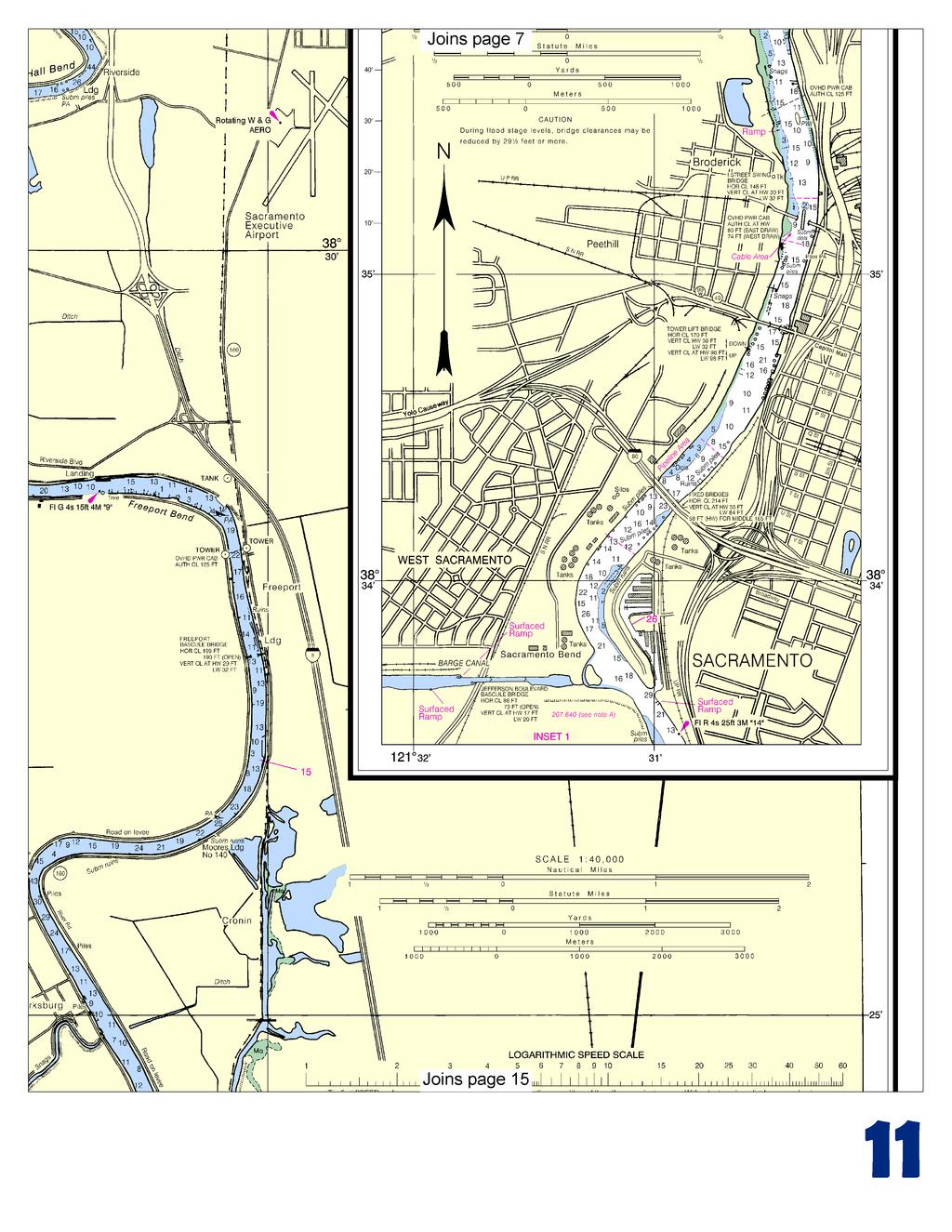
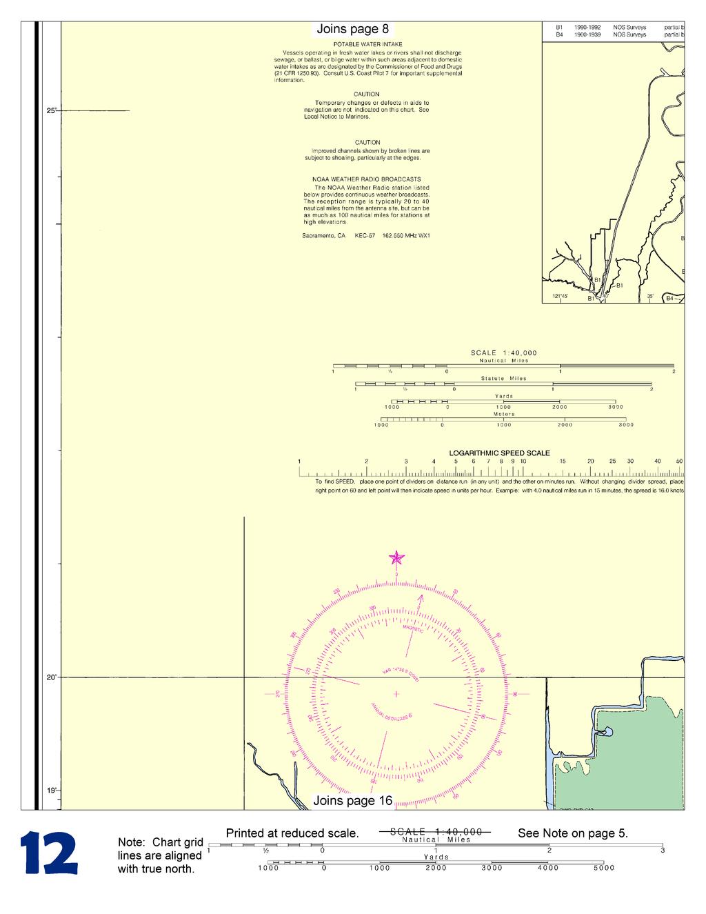
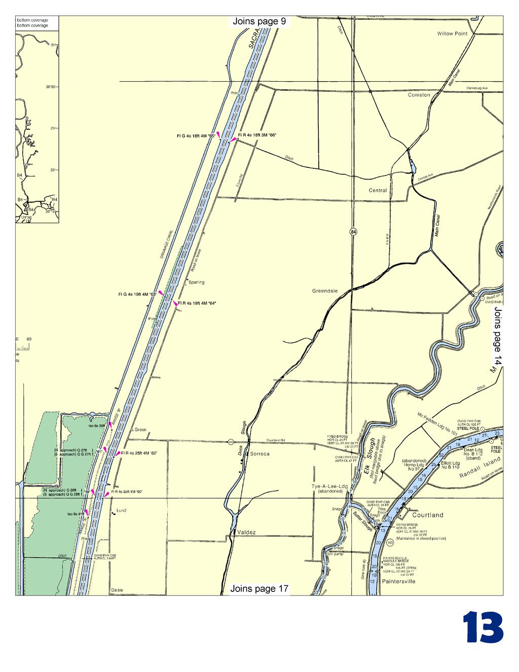
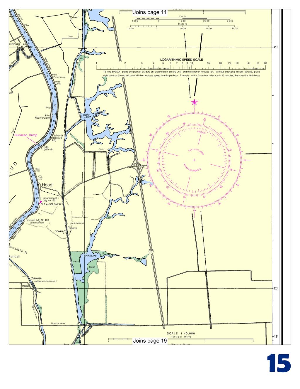
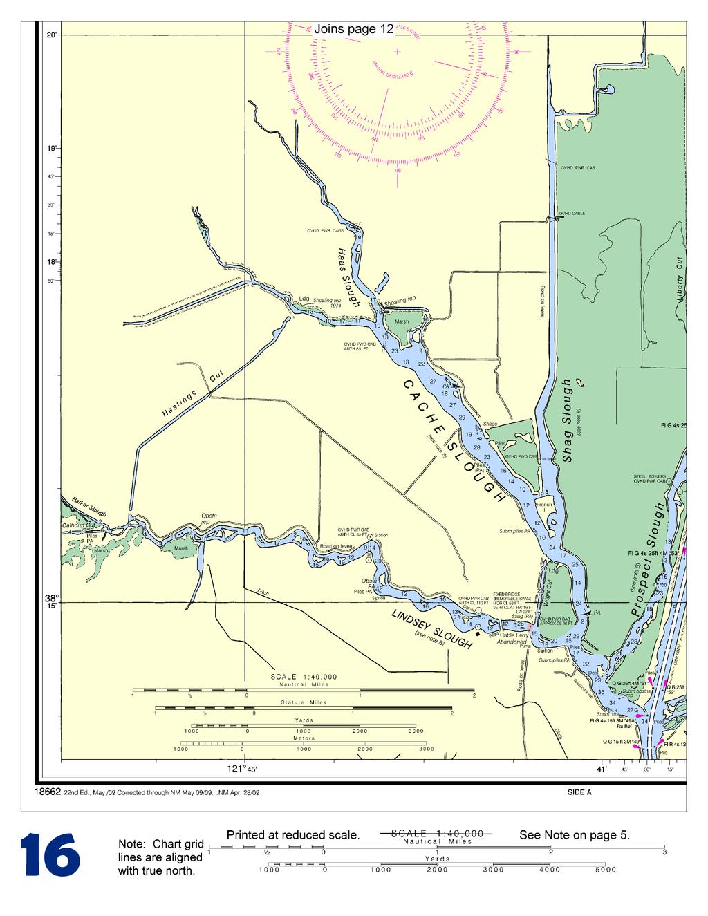
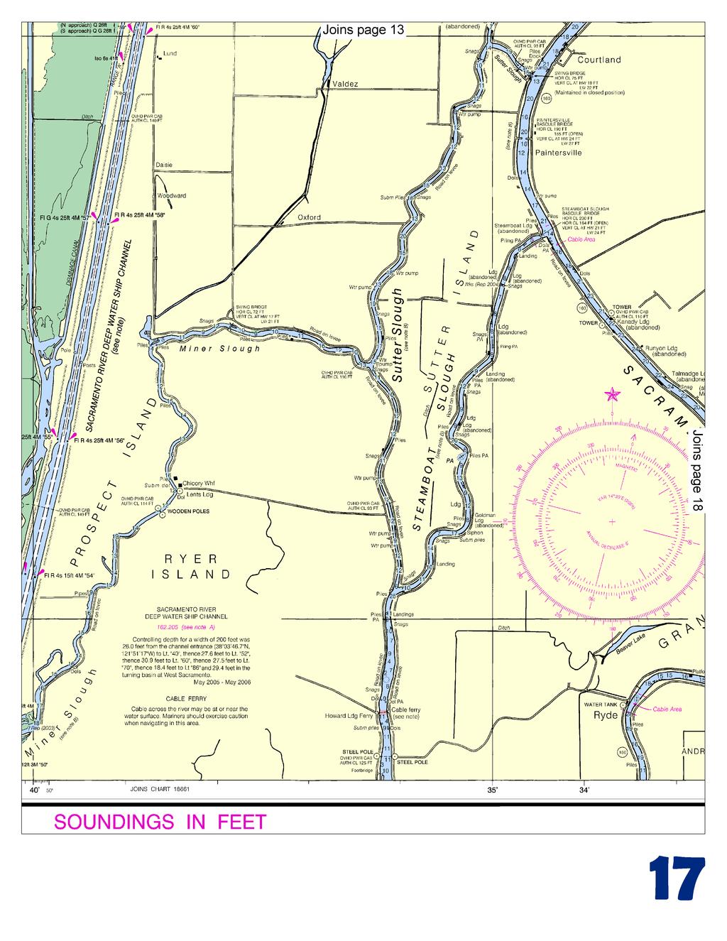
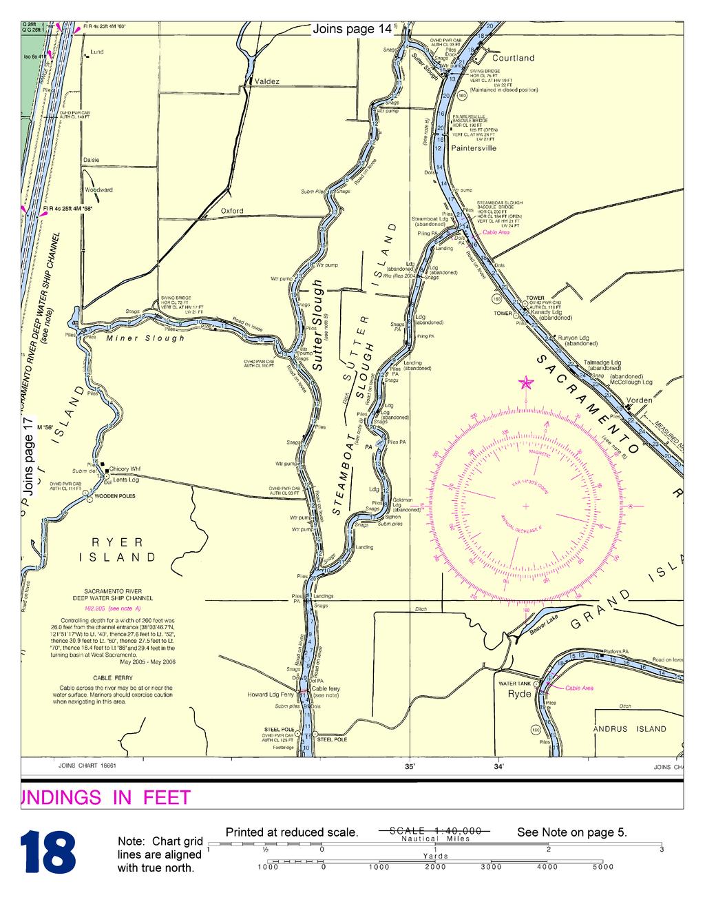
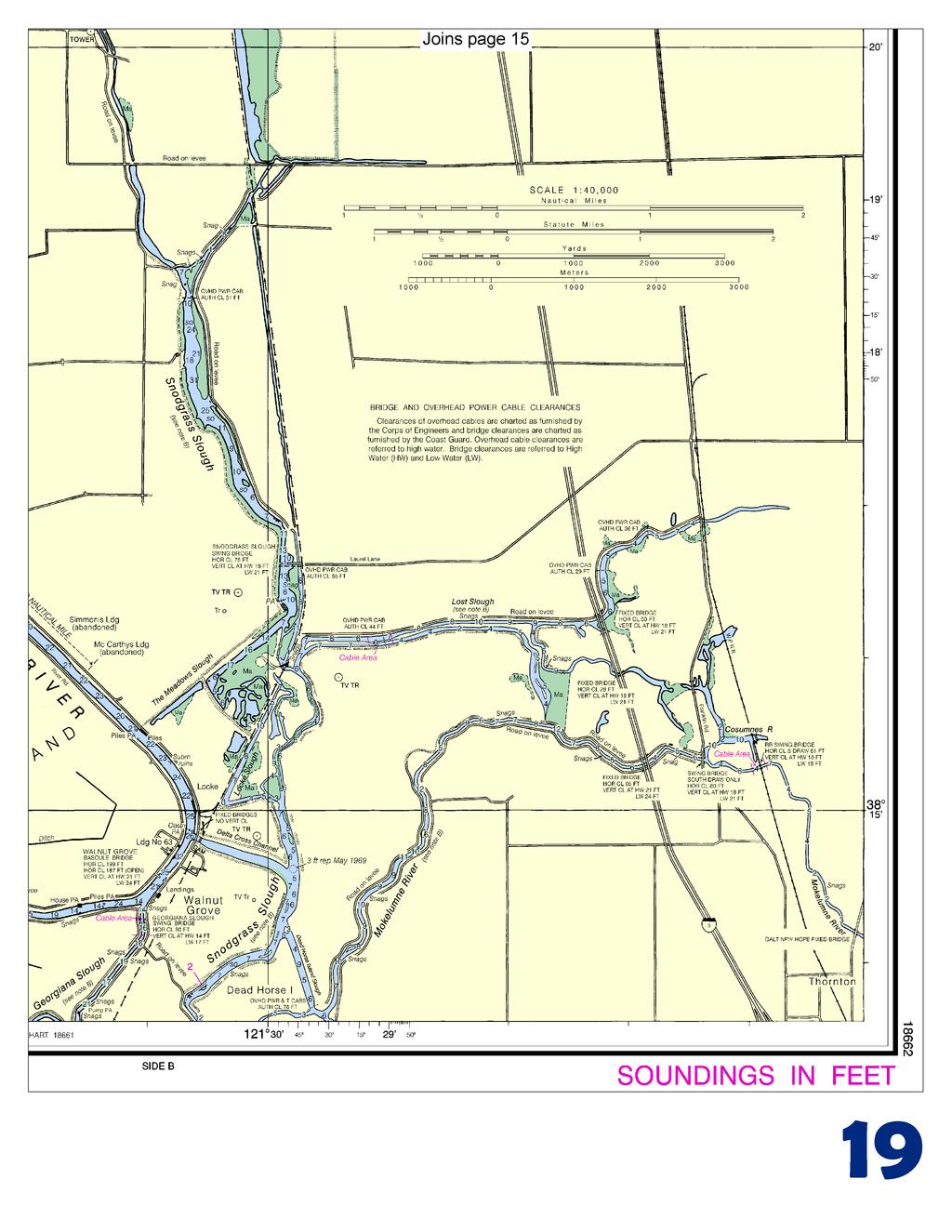
1 BookletChart Sacramento River Andrus Island to Sacramento NOAA Chart A reduced-scale NOAA nautical chart for small boaters When possible, use the full-size NOAA chart for navigation. Included Area

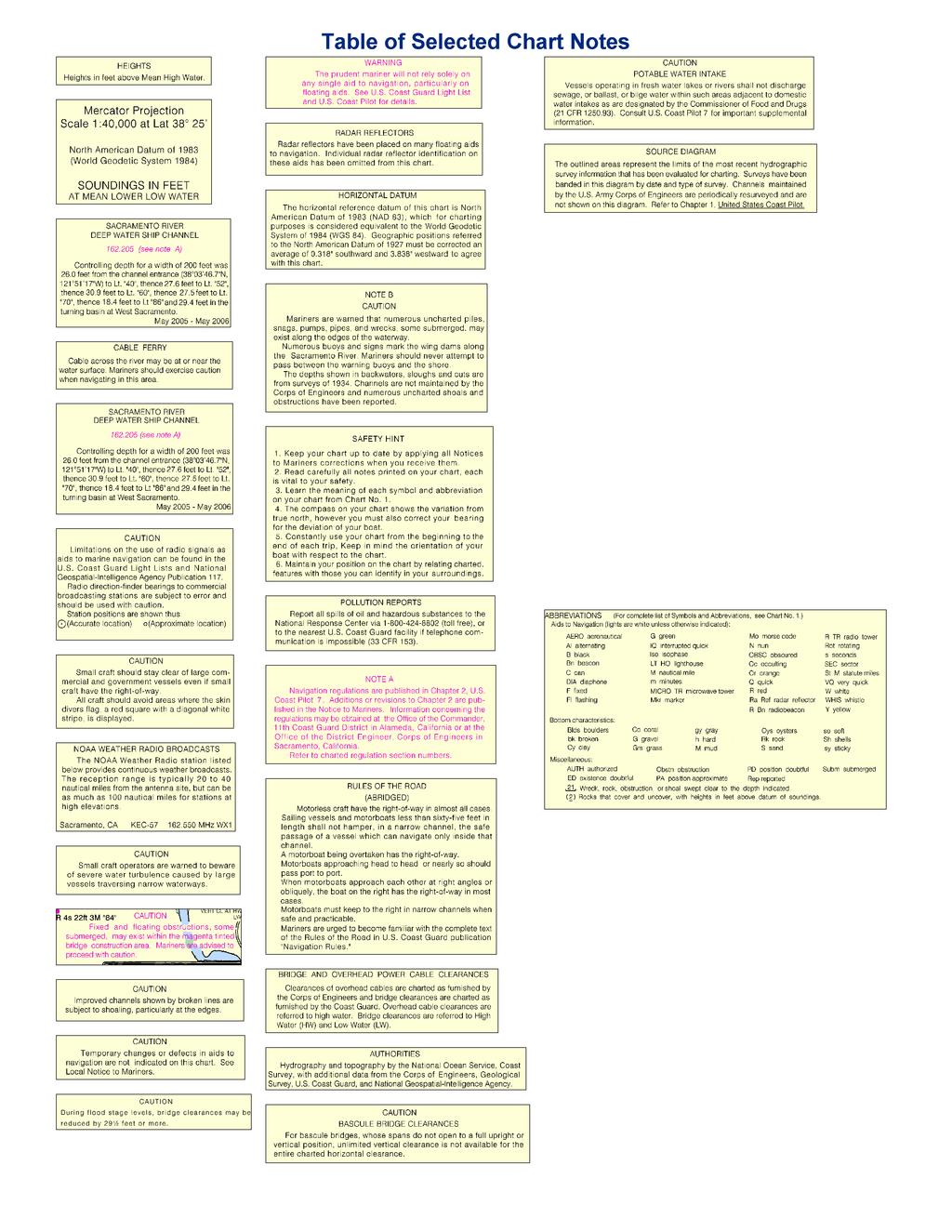
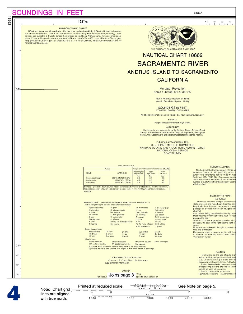
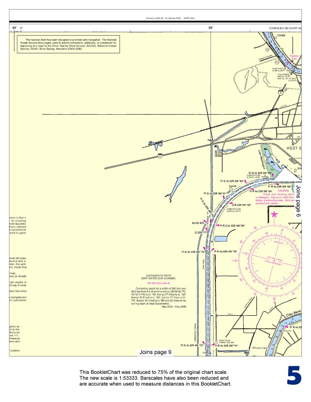
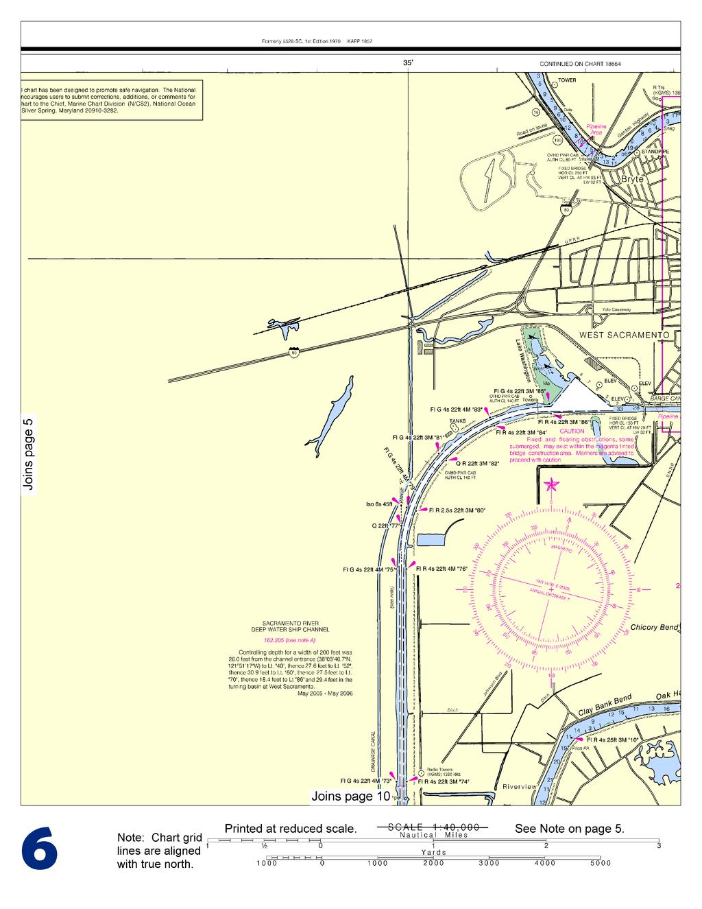
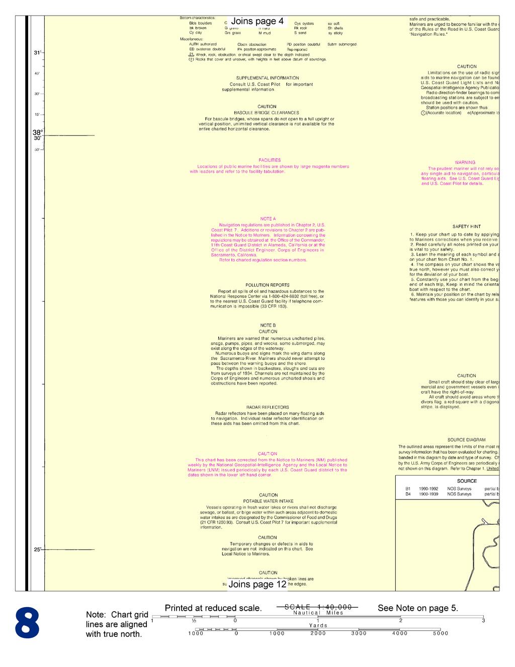
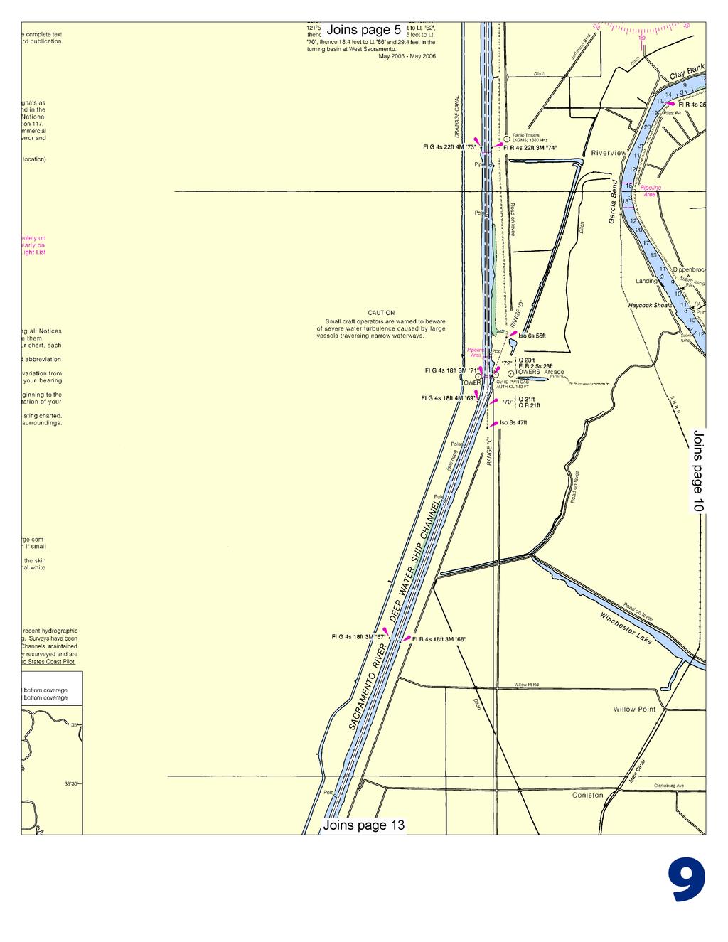
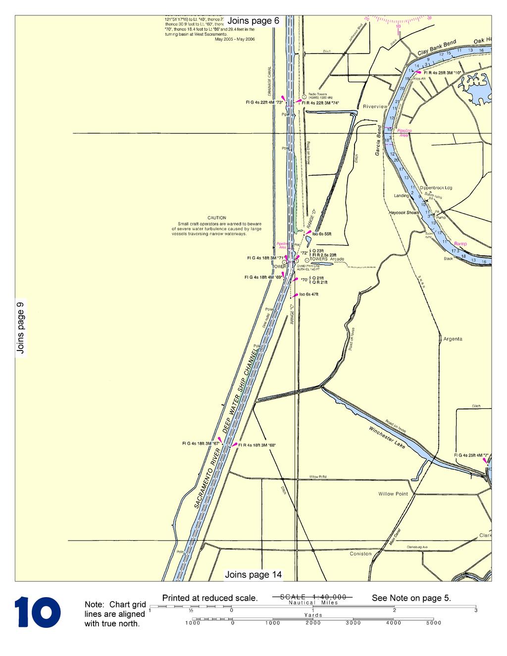
2 Published by the National Oceanic and Atmospheric Administration National Ocean Service Office of Coast Survey NOAA What are Nautical Charts? Nautical charts are a fundamental tool of marine navigation. They show water depths, obstructions, buoys, other aids to navigation, and much more. The information is shown in a way that promotes safe and efficient navigation. Chart carriage is mandatory on the commercial ships that carry America s commerce. They are also used on every Navy and Coast Guard ship, fishing and passenger vessels, and are widely carried by recreational boaters. What is a BookletChart? This BookletChart is made to help recreational boaters locate themselves on the water. It has been reduced in scale for convenience, but otherwise contains all the information of the full-scale nautical chart. The bar scales have also been reduced, and are accurate when used to measure distances in this BookletChart. See the Note at the bottom of page 5 for the reduction in scale applied to this chart. Whenever possible, use the official, full scale NOAA nautical chart for navigation. Nautical chart sales agents are listed on the Internet at This BookletChart does NOT fulfill chart carriage requirements for regulated commercial vessels under Titles 33 and 44 of the Code of Federal Regulations. Notice to Mariners Correction Status This BookletChart has been updated for chart corrections published in the U.S. Coast Guard Local Notice to Mariners, the National Geospatial Intelligence Agency Weekly Notice to Mariners, and, where applicable, the Canadian Coast Guard Notice to Mariners. Additional chart corrections have been made by NOAA in advance of their publication in a Notice to Mariners. The last Notices to Mariners applied to this chart are listed in the Note at the bottom of page 7. Coast Pilot excerpts are not being corrected. For latest Coast Pilot excerpt visit the Office of Coast Survey website at (Selected Excerpts from Coast Pilot) The Delta Region, the combined deltas of the San Joaquin and Sacramento Rivers, comprises the feeder rivers, sloughs, and canals that directly or indirectly connect with one or both of the rivers. Hundreds of miles of navigable waterways for small boats are available in the Delta; both local and visiting small craft use these waterways extensively. Bordering the various waterways are levees which are 12 feet or more higher than the land behind them. The levees are built up from dredged material taken from the adjacent waterway, and because of the settlement of the levees, dredging has been done periodically to keep the tops at height and grade. As material is needed for levee work, the dredge pays more attention to the requirements of the levee than to the depth of the channel for navigation purposes. This leaves an uneven bottom. Many public and private small-boat harbors, marinas, and boating resorts are spread over the Delta region. All types of facilities and services for small craft are available, though some areas in the Delta are much more developed than others. Cable ferries. The Sacramento and San Joaquin Rivers, including some of the feeder rivers, sloughs, and canals that directly or indirectly connect with one or both of the rivers, are crossed by cable ferries (see charts and 18662). These ferries in the delta region are guided by cables and sometimes propelled by a cable rig attached to the shore. Cables to the ferries, which extend from both banks of the waterway, may be at, near, or above the water surface. Operating procedures vary and mariners are advised to use extreme caution and seek local knowledge. DO NOT ATTEMPT TO PASS A MOVING CABLE FERRY. Threemile Slough meets the San Joaquin River 5.8 miles above Antioch Bridge and joins the Sacramento River at the N end of Decker Island. The slough is a route frequently used by tugs and barges making passage between Sacramento and Stockton. Mokelumne River, one of the principal tributaries of the San Joaquin River, rises in the Sierra Nevada and empties into it 11.8 miles above Antioch Bridge. Sacramento River rises in the Trinity Mountains in N central California, flows S for 325 miles, and enters Suisun Bay on the N side of Sherman Island. A cable ferry crosses the Steamboat Slough about 5 miles above the junction with Cache Slough. Sacramento River Deep Water Ship Channel extends from Suisun Bay through lower Sacramento River, Cache Slough, and a 22-mile land cut to a triangular harbor and turning basin at the Port of Sacramento. The William G. Stone Lock is on the barge canal that once connected the Deep Water Ship Channel with the Sacramento River; the lock is closed to all navigation. The project depth in the ship channel is generally maintained. (See Notice to Mariners and latest editions of charts for controlling depths.) The controlling depth in the river route is about 10 feet. Above Sacramento, the controlling depth is about 6 feet to Colusa. The sounding datum is mean lower low water at low-river stage. Numerous uncharted piles, snags, pumps, and pipes, some submerged, may exist along the edges of the river. Mariners are advised to exercise extreme caution while navigating close to the banks of the river. Note. Care should be exercised at all times to keep clear of the levees, as most of them are faced with rock which may damage vessels that drag along them. Pilotage, Sacramento River. River pilots, commissioned by the Port of Sacramento, are arranged for by the ship s agents, but may be obtained through the office of the port of Sacramento or the San Francisco Bar Pilots Quarantine, customs, immigration, and agricultural quarantine. (See chapter 3, Vessel Arrival Inspections, and Appendix A for addresses.) Quarantine is enforced in accordance with regulations of the U.S. Public Health Service. (See Public Health Service, chapter 1.) 2 U.S. Coast Guard Rescue Coordination Center 24 hour Regional Contact for Emergencies RCC Alameda Commander 11 th CG District (510) Alameda, CA
3
4
5
6
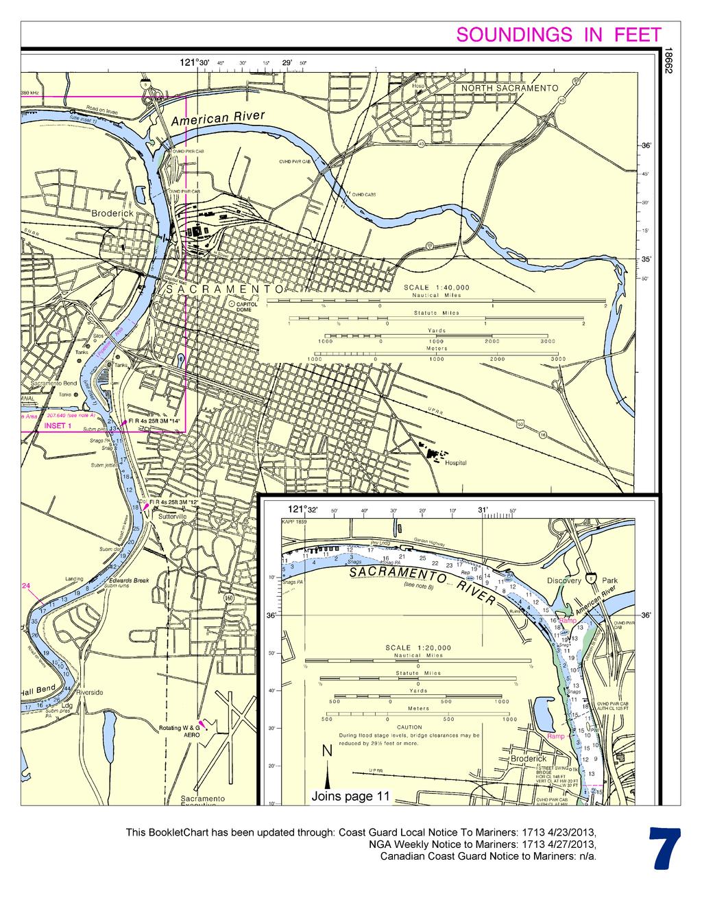
7
8
9
10
11
12
13

14
15
16
17
18
19


20 VHF Marine Radio channels for use on the waterways: Channel 6 Inter-ship safety communications. Channel 9 Communications between boats and ship-to-coast. Channel 13 Navigation purposes at bridges, locks, and harbors. EMERGENCY INFORMATION Channel 16 Emergency, distress and safety calls to Coast Guard and others, and to initiate calls to other vessels. Contact the other vessel, agree to another channel, and then switch. Channel 22A Calls between the Coast Guard and the public. Severe weather warnings, hazards to navigation and safety warnings are broadcast here. Channels 68, 69, 71, 72 and 78A Recreational boat channels. Getting and Giving Help Signal other boaters using visual distress signals (flares, orange flag, lights, arm signals); whistles; horns; and on your VHF radio. You are required by law to help boaters in trouble. Respond to distress signals, but do not endanger yourself. Distress Call Procedures Make sure radio is on. Select Channel 16. Press/Hold the transmit button. Clearly say: MAYDAY, MAYDAY, MAYDAY. Also give: Vessel Name and/or Description; Position and/or Location; Nature of Emergency; Number of People on Board. Release transmit button. Wait for 10 seconds If no response Repeat MAYDAY call. HAVE ALL PERSONS PUT ON LIFE JACKETS! NOAA Weather Radio All Hazards (NWR) is a nationwide network of radio stations broadcasting continuous weather information directly from the nearest National Weather Service office. NWR broadcasts official Weather Service warnings, watches, forecasts and other hazard information 24 hours a day, 7 days a week. Quick References Nautical chart related products and information - Online chart viewer - Report a chart discrepancy - Chart and chart related inquiries and comments - Chart updates (LNM and NM corrections) - QR Coast Pilot online - Tides and Currents - Marine Forecasts - National Data Buoy Center - NowCoast web portal for coastal conditions - National Weather Service - National Hurrican Center - Pacific Tsunami Warning Center - Contact Us - For the latest news from Coast Survey, This Booklet chart has been designed for duplex printing (printed on front and back of one sheet). If a duplex option is not available on your printer, you may print each sheet and arrange them back-to-back to allow for the proper layout when viewing. NOAA s Office of Coast Survey The Nation s Chartmaker
BookletChart. Sacramento River Sacramento to Fourmile Bend NOAA Chart A reduced-scale NOAA nautical chart for small boaters
 BookletChart Sacramento River Sacramento to Fourmile Bend NOAA Chart 18664 A reduced-scale NOAA nautical chart for small boaters When possible, use the full-size NOAA chart for navigation. Included Area
BookletChart. Intracoastal Waterway Grassy Key to Bahia Honda Key NOAA Chart A reduced-scale NOAA nautical chart for small boaters
 BookletChart Intracoastal Waterway Grassy Key to Bahia Honda Key NOAA Chart 11453 A reduced-scale NOAA nautical chart for small boaters When possible, use the full-size NOAA chart for navigation. Published
BookletChart. Chesapeake Bay Pocomoke and Tangier Sounds NOAA Chart A reduced-scale NOAA nautical chart for small boaters
 BookletChart Chesapeake Bay Pocomoke and Tangier Sounds NOAA Chart 12228 A reduced-scale NOAA nautical chart for small boaters When possible, use the full-size NOAA chart for navigation. Published by the
BookletChart. Port-au-Prince (Haiti) NGA Chart A reduced-scale NGA nautical chart for small boaters
 NGA Chart A reduced-scale NGA nautical chart for small boaters") BookletChart Port-au-Prince (Haiti) NGA Chart 26186 A reduced-scale NGA nautical chart for small boaters When possible, use the full-size NGA chart or Electronic Nautical Chart (ENC) for navigation. VHF
BookletChart Port-au-Prince (Haiti) NGA Chart 26186 A reduced-scale NGA nautical chart for small boaters When possible, use the full-size NGA chart or Electronic Nautical Chart (ENC) for navigation. VHF
Passages Between Acklins Island, Haiti and Caicos Islands NGA Chart A reduced-scale NGA nautical chart for small boaters
 BookletChart Passages Between Acklins Island, Haiti and Caicos Islands NGA Chart 26260 A reduced-scale NGA nautical chart for small boaters When possible, use the full-size NGA chart or Electronic Nautical
BookletChart. St. Joseph and Benton Harbor NOAA Chart A reduced-scale NOAA nautical chart for small boaters
 BookletChart St. Joseph and Benton Harbor NOAA Chart 14930 A reduced-scale NOAA nautical chart for small boaters When possible, use the full-size NOAA chart for navigation. Included Area Published by the
BookletChart. Cap-Haitien NGA Chart A reduced-scale NGA nautical chart for small boaters
 BookletChart Cap-Haitien NGA Chart 26146 A reduced-scale NGA nautical chart for small boaters When possible, use the full-size NGA chart or Electronic Nautical Chart (ENC) for navigation. VHF Marine Radio
Baie de L Acul and Approaches (Haiti) NGA Chart A reduced-scale NGA nautical chart for small boaters
 NGA Chart A reduced-scale NGA nautical chart for small boaters") BookletChart Baie de L Acul and Approaches (Haiti) NGA Chart 26148 A reduced-scale NGA nautical chart for small boaters When possible, use the full-size NGA chart or Electronic Nautical Chart (ENC) for
BookletChart Baie de L Acul and Approaches (Haiti) NGA Chart 26148 A reduced-scale NGA nautical chart for small boaters When possible, use the full-size NGA chart or Electronic Nautical Chart (ENC) for
BookletChart. Approaches to Cap-Haitien and Bahia de Monti Cristi NGA Chart A reduced-scale NGA nautical chart for small boaters
 BookletChart Approaches to Cap-Haitien and Bahia de Monti Cristi NGA Chart 26142 A reduced-scale NGA nautical chart for small boaters When possible, use the full-size NGA chart or Electronic Nautical Chart
BookletChart. Island of O ahu NOAA Chart A reduced-scale NOAA nautical chart for small boaters
 BookletChart Island of O ahu NOAA Chart 19357 A reduced-scale NOAA nautical chart for small boaters When possible, use the full-size NOAA chart for navigation. Included Area Published by the National Oceanic
PRODUCTS AND SERVICES FOR THE MARITIME COMMUNITY. Ed Martin, Chief Customer Affairs Branch Navigation Services Division Monday, 27 October, 2008
 PRODUCTS AND SERVICES FOR THE MARITIME COMMUNITY Ed Martin, Chief Customer Affairs Branch Navigation Services Division Monday, 27 October, 2008 Coral Reef Conservation International Collaboration Marine
Standard Operating Procedures for: VHF Marine Radio
 Serenity Houseboat I. Overview Standard Operating Procedures for: VHF Marine Radio VHF, or Very High Frequency, marine radio is the standard method of communication between vessels. Marine radio equipment
LT Matthew Forney, NOAA Navigation Manager Alaska Region Bering Strait MaritimeSymposium. Office of Coast Survey
 NOAA LT Matthew Forney, NOAA Navigation Manager Alaska Region Bering Strait MaritimeSymposium Who is Coast Survey? First science agency of the U.S. Formed in 1807 Responsible for surveying 3.4 million
MARITIME SAFETY INFORMATION
 Introduction 1. Maritime Safety Information (MSI) is defined as navigational and meteorological warnings, meteorological forecasts, and other urgent safety-related messages. This information is of vital
(P.27)
") (P.27) 27 7 210 120 8 * Navigation and Anchoring Prohibited Area has been changed since June, 2017. 9 Port of Osaka The Guidelines of Measures for preventing Typhoon Disaster ( Objective )
(P.27) 27 7 210 120 8 * Navigation and Anchoring Prohibited Area has been changed since June, 2017. 9 Port of Osaka The Guidelines of Measures for preventing Typhoon Disaster ( Objective )
there is a description of the vessel, you will substitute the prop description of your boat. VHF Booklet
 VHF Booklet Imagine what may happen if a distress situation were to take place and you or a guest on your boat needed to place some form of priority call. In the excitement of the moment, it is easy to
GMDSS for Recreational Boaters
 GMDSS for Recreational Boaters OVERVIEW The Global Maritime Distress and Safety System (GMDSS) is an international system using advanced communications technology. Development of GMDSS was initiated by
NOAA s National Ocean Service / Office of Coast Survey
 Coast Survey OCS 1807 2007 Maintains over 1000 nautical charts & 9 Coast Pilots Surveys over 3.4M SNM of oceans and lakes Conducts research and development in hydrography Thomas Jefferson Founder of The
SECTION III NM 50/12 MARINE INFORMATION NOAA CHART NEW EDITIONS AND THEIR AVAILABILITY
 SECTION III NM 50/12 MARINE INFORMATION NOAA CHART NEW EDITIONS AND THEIR AVAILABILITY NOAA recognizes two paper nautical chart products: - the Print-on-Demand (POD) chart distributed by OceanGrafix (www.oceangrafix.com),
SECTION III NM 34/14 MARINE INFORMATION
 MARINE INFORMATION AREAS TO BE AVOIDED (OCEANOGRAPHIC MOORINGS) IN THE EQUATORIAL PACIFIC OCEAN The National Oceanic and Atmospheric Administration (NOAA) maintains various buoys in the Equatorial Pacific
SECTION III NM 24/15 MARINE INFORMATION
 SECTION III NM 24/15 MARINE INFORMATION NATIONAL GEOSPATIAL-INTELLIGENCE AGENCY'S (NGA) GUIDANCE ON THE PROPER DISPLAY SCALE OF DIGITAL NAUTICAL CHART (DNC) DATA The DNC portfolio was originally created
Drawbridge Operation Regulation; Oakland Inner Harbor, ACTION: Notice of deviation from drawbridge regulation.
 This document is scheduled to be published in the Federal Register on 03/06/2015 and available online at http://federalregister.gov/a/2015-05231, and on FDsys.gov 9110-04-P DEPARTMENT OF HOMELAND SECURITY
Proposed Anchorage Grounds, Hudson River; Yonkers, NY to Kingston, NY Docket Number USCG
 August 8, 2016 U.S. Coast Guard First District C/O Mr. Craig Lapiejko Waterways Management Branch Submitted Via Federal erulemaking Portal Subject: Proposed Anchorage Grounds, Hudson River; Yonkers, NY
FOR MORE INFORMATION ON GMDSS CONTACT:
 FOR MORE INFORMATION ON GMDSS CONTACT: Commanding Officer USCG Navigation Center, MS 7310, 7323 Telegraph Road, Alexandria, VA 20598-7310 Tel:1-703-313-5900 www.navcen.uscg.gov Commandant (CG-652) Spectrum
SAFETY EQUIPMENT AND PREPARATION. S/V Odette USA 5619
 SAFETY EQUIPMENT AND PREPARATION S/V Odette USA 5619 Odette5619@gmail.com COMMUNICATION PREPARATION Dedicate dock time for crew to familiarize themselves with all communication equipment: VHF: Walk through
The Future in Marine Radio Communication GMDSS. Department of Transportation United States Coast Guard
 The Future in Marine Radio Communication GMDSS Department of Transportation United States Coast Guard Do you use a Maritime Radio System? If so, the new Global Maritime Distress and Safety System (GMDSS)
SECTION III NM 35/10 MARINE INFORMATION NOAA CHART NEW EDITIONS AND THEIR AVAILABILITY
 SECTION III NM 35/10 MARINE INFORMATION NOAA CHART NEW EDITIONS AND THEIR AVAILABILITY NOAA recognizes two paper nautical chart products: - the Print-on-Demand (POD) chart distributed by OceanGrafix (www.oceangrafix.com),
How Automatic Identification System (AIS) Is Being Used to Improve Navigation Safety Lock Operations Management Application Michael Winkler
 Is Being Used to Improve Navigation Safety Lock Operations Management Application Michael Winkler") How Automatic Identification System (AIS) Is Being Used to Improve Navigation Safety Lock Operations Management Application Michael Winkler June 2016 LOMA system overview USCG AIS data capabilities: AIS
How Automatic Identification System (AIS) Is Being Used to Improve Navigation Safety Lock Operations Management Application Michael Winkler June 2016 LOMA system overview USCG AIS data capabilities: AIS
RADIO AIDS TO MARINE NAVIGATION (Atlantic, St. Lawrence, Great Lakes, Lake Winnipeg and Eastern Arctic) CANADIAN COAST GUARD
 CANADIAN COAST GUARD") RADIO AIDS TO MARINE NAVIGATION (Atlantic, St Lawrence, Great Lakes, Lake Winnipeg and Eastern Arctic) CANADIAN COAST GUARD Marine Communications and Traffic Services Annual Edition 2006 IMPORTANT This
RADIO AIDS TO MARINE NAVIGATION (Atlantic, St Lawrence, Great Lakes, Lake Winnipeg and Eastern Arctic) CANADIAN COAST GUARD Marine Communications and Traffic Services Annual Edition 2006 IMPORTANT This
RESOLUTION MSC.278(85) (adopted on 1 December 2008) ADOPTION OF THE NEW MANDATORY SHIP REPORTING SYSTEM "OFF THE COAST OF PORTUGAL - COPREP"
 (adopted on 1 December 2008) ADOPTION OF THE NEW MANDATORY SHIP REPORTING SYSTEM OFF THE COAST OF PORTUGAL - COPREP") MSC 85/26/Add.1 RESOLUTION MSC.278(85) SYSTEM OFF THE COAST OF PORTUGAL COPREP THE MARITIME SAFETY COMMITTEE, RECALLING Article 28 of the Convention on the International Maritime Organization concerning
MSC 85/26/Add.1 RESOLUTION MSC.278(85) SYSTEM OFF THE COAST OF PORTUGAL COPREP THE MARITIME SAFETY COMMITTEE, RECALLING Article 28 of the Convention on the International Maritime Organization concerning
HDD Wire Guided Waterway Crossing ATON Plan. Youghiogheny River (S122)
") HDD Wire Guided Waterway Crossing ATON Plan Youghiogheny River (S122) Mariner East Phase 2 Pipeline Project Prepared for: Sunoco Pipeline, L.P. 535 Friztown Road Sinking Springs, PA 19608 Prepared by:
HDD Wire Guided Waterway Crossing ATON Plan Youghiogheny River (S122) Mariner East Phase 2 Pipeline Project Prepared for: Sunoco Pipeline, L.P. 535 Friztown Road Sinking Springs, PA 19608 Prepared by:
Western Region enavigation Sub- Committee Report
 Western Region enavigation Sub- Committee Report Western Region enavigation meeting - Jan 12 18 BC Ferries BC Coast Pilots BCIT Marine Campus Canadian Coast Guard Canadian Hydrographic Services Canadian
Corps Dredge Plan 2016 Emily Hughes Env Resources, USACE BUILDING STRONG
 Corps Dredge Plan 2016 Emily Hughes Env Resources, USACE Goodbye Jeff Richter!! Navigation/Operations USACE Goal/Mission: To maintain safe Navigation in Federal Channels using methods that are most (1)
SECTION III NM 15/12 MARINE INFORMATION
 SECTION III NM 15/12 MARINE INFORMATION CHANGES TO BROADCAST OF WEATHER FORECASTS FOR THE OFFSHORE SOUTHWEST NORTH ATLANTIC, CARIBBEAN, AND GULF OF MEXICO Effective Tuesday April 03, 2012 at 2:00 pm Eastern
Emergency Marine Communications
 Emergency Marine Communications Presented by: Steve Chamberlin Content:Chuck Hawley Safety at Sea Seminar US Sailing Goals of Emergency Communications To alert rescue services to your situation To get
Notice to Mariner No. 213
 To : Attn: From: All Agents, Bunkering Companies, Coast Guard, National Transport Authority, Hydrographic Office Operations Manager Capt. Tamer Masoud Harbour Master Facsimile No.: City: Fujairah Country:
PROVIDING KNOWLEDGE AND KNOWHOW... ANYTIME, ANYWHERE LIGHT LIST. Reference Materials. Digital Edition. Captain Robert L. Figular
 PROVIDING KNOWLEDGE AND KNOWHOW... ANYTIME, ANYWHERE LIGHT LIST Reference Materials Digital Edition Captain Robert L. Figular Page intentionally left blank LIGHT LIST Atlantic Coast of North America MLS
SECTION III NM 40/17 MARINE INFORMATION
 SECTION III NM 40/17 MARINE INFORMATION NEW EDITION OF COAST PILOT U.S. Coast Pilot 4, Atlantic Coast: Cape Henry, VA to Key West, FL, forty-ninth edition, 2017, has been issued and is ready for free download
United States Coast Guard Office of Navigation Systems
 United States Coast Guard Office of Navigation Systems Future of Navigation Initiatives & Operations R. David Lewald Program Analyst Navigation Systems Office of Navigation Systems U.S. Coast Guard Washington,
Radio Log Book. for Canadian Flag Vessels. 1 Master s Signature. Transports Canada. Transport Canada TP 13926E MARINE SAFETY
 Transport Canada MARINE SAFETY Transports Canada TP 13926E Radio Log Book for Canadian Flag Vessels Also for use on GMDSS exempted vessels Date Commenced Date Completed 1 Instructional Guide for Keeping
CPRNW. WWNWS9/3/3/3.2 Meeting 9 20 July 2017 Agenda Item Joint MET/NAVAREA XVII and XVIII Client Survey
 CPRNW WWNWS WWNWS9/3/3/3.2 Meeting 9 20 July 2017 Agenda Item 3.3.3.2 Joint MET/NAVAREA XVII and XVIII Client Survey Submitted by Canada, NAVAREA XVII_XVIII SUMMARY Executive Summary: This document describes
Using a Pilot Laptop with the AIS pilot plug - observed errors and difficulties
 Using a Pilot Laptop with the AIS pilot plug - observed errors and difficulties 2 nd November 2008 The following pages and images detail the errors found and experience in using his Pilot Laptop by a Australian
DOWNLOAD OR READ : THE NAUTICAL CHART PDF EBOOK EPUB MOBI
 DOWNLOAD OR READ : THE NAUTICAL CHART PDF EBOOK EPUB MOBI Page 1 Page 2 the nautical chart the nautical chart pdf the nautical chart NOAA ENCs (ENC): Vector files of chart features and available in S-57
SECTION III NM 17/15 MARINE INFORMATION
 SECTION III NM 17/15 MARINE INFORMATION NOAA CHART NEW EDITIONS AND THEIR AVAILABILITY NOAA produces nautical chart products to support Federal chart carriage requirements. These nautical charts are available
Procedure VHF Communication VTS and HCC Port of Rotterdam Authority Harbour Master's Division
 Procedure VHF Communication VTS and HCC Port of Rotterdam Authority Harbour Master's Division Author: B. Röhner Date: Contents 1. PROCEDURE VHF COMMUNICATION VESSEL TRAFFIC SERVICES (VTS)... 1 2. Area
NAVIGA TIONAL VIGA WARNINGS/MSI/GMDSS N NAV NA AREA III VIII
 NAVIGATIONAL WARNINGS/MSI/GMDSS IN NAVAREA VIII 5/16/2008 1 SCOPE OF PRESENTATION 1. Introduction 2. Navarea VIII Radio Warnings 3. Indian Notices to Mariners 4. Implementation of GMDSS 5. Marine Safety
Port Security and Technology - the U.S. Perspective. Michael S. Bruno Stevens Institute of Technology March 14, 2012
 Port Security and Technology - the U.S. Perspective Michael S. Bruno Stevens Institute of Technology March 14, 2012 CSR A Department of Homeland Security National Center of Excellence for Port Security
Meeting 10 8 August 2018 Agenda Item 2.1. MSI Self Assessment NAVAREA XVI. Submitted by PERÚ - DIRECTORATE OF HYDROGRAPHY AND NAVIGATION SUMMARY
 WWNWS10 WWNWS10/2/1-XVI Meeting 10 8 August 2018 Agenda Item 2.1 MSI Self Assessment NAVAREA XVI Submitted by PERÚ - DIRECTORATE OF HYDROGRAPHY AND NAVIGATION SUMMARY Executive Summary: Report of activities
SUMMARY: The Coast Guard is declaring Sea Area A1 in certain. areas off the coast of the United States based upon the
 DEPARTMENT OF HOMELAND SECURITY Coast Guard [Docket No. USCG-2015-0002] Declaration of Sea Area A1 ACTION: Notice. This document is scheduled to be published in the Federal Register on 01/20/2015 and available
SECTION III NM 32/13 MARINE INFORMATION NOAA CHART NEW EDITIONS AND THEIR AVAILABILITY
 MARINE INFORMATION NOAA CHART NEW EDITIONS AND THEIR AVAILABILITY NOAA recognizes two paper nautical chart products: Print-on-Demand (POD) and traditional paper charts. - Print-on-Demand (POD) charts are
Event Organisers are advised to consider having a dedicated channel for safety and rescue communications.
 RowSafe Effective use of the radios relies on keeping transmissions short and to the point, speaking clearly and following basic internationally recognised procedure. The following guidelines are based
RESOLUTION MSC.230(82) (adopted on 5 December 2006) ADOPTION OF AMENDMENTS TO THE EXISTING MANDATORY SHIP REPORTING SYSTEM "IN THE STOREBÆLT (GREAT
 (adopted on 5 December 2006) ADOPTION OF AMENDMENTS TO THE EXISTING MANDATORY SHIP REPORTING SYSTEM IN THE STOREBÆLT (GREAT") MSC 82/24/Add.2 RESOLUTION MSC.230(82) MANDATORY SHIP REPORTING SYSTEM IN THE STOREBÆLT (GREAT BELT) TRAFFIC AREA THE MARITIME SAFETY COMMITTEE, RECALLING Article 28(b) of the Convention on the International
MSC 82/24/Add.2 RESOLUTION MSC.230(82) MANDATORY SHIP REPORTING SYSTEM IN THE STOREBÆLT (GREAT BELT) TRAFFIC AREA THE MARITIME SAFETY COMMITTEE, RECALLING Article 28(b) of the Convention on the International
DEVELOPMENT OF A DEFINITION FOR MSPS AND CONSIDERATION FOR THE HARMONIZATION OF THE FORMAT AND STRUCTURE OF MSPS
 INTERNATIONAL HYDROGRAPHIC ORGANIZATION E IMO/IHO HARMONIZATION GROUP ON DATA MODELLING Agenda item 5 15 September 2017 ENGLISH ONLY DEVELOPMENT OF A DEFINITION FOR MSPS AND CONSIDERATION FOR THE HARMONIZATION
Policy Research Corporation
 Policy Research Corporation SOUND SOLUTIONS BASED ON SCIENTIFIC RESEARCH The role of Maritime Clusters to enhance the strength and development of maritime sectors Country report Poland INTRODUCTION TO
SECTION III NM 39/13 MARINE INFORMATION NGA CHART NEW EDITIONS AND THEIR AVAILABILITY
 SECTION III NM 39/13 MARINE INFORMATION NGA CHART NEW EDITIONS AND THEIR AVAILABILITY NGA standard nautical hardcopy chart products are made available and distributed by three different authorized methods:
SECTION III NM 41/14 MARINE INFORMATION
 MARINE INFORMATION NOAA CHART NEW EDITIONS AND THEIR AVAILABILITY NOAA recognizes two paper nautical chart products: Print-on-Demand (POD) and traditional paper charts. - Print-on-Demand (POD) charts are
GMDSS communication systems
 GMDSS Basic Concepts A System Overview Functional requirements The GMDSS (Global Maritime Distress and Safety System) is specifically designed to automate a ship's radio distress alerting function, and,
How to Conduct a Bridge to Bridge Inspection
 How to Conduct a Bridge to Bridge Inspection 80.1001 Applicability. The Bridge-to-Bridge Act and the regulations of this part apply to the following vessels in the navigable waters of the United States:
Government Agency Perspectives & Initiatives Canadian Coast Guard Laurent Tardif, Director, Safe Shipping
 Unclassified Government Agency Perspectives & Initiatives Canadian Coast Guard Laurent Tardif, Director, Safe Shipping Mariner s Workshop January 23, 2019 1 Overview 1 Context 2 Marine Fees 3 4 5 Update
No MARCH 2014 UNITED STATES OF AMERICA. Contents
 10 8 MARCH 2014 UNITED STATES OF AMERICA Published Weekly by the National Geospatial-Intelligence Agency Prepared Jointly with the National Ocean Service and U.S. Coast Guard Contents Section I Chart Corrections............................................
SECTION III NM 4/16 MARINE INFORMATION
 MARINE INFORMATION NOAA CHART NEW EDITIONS AND THEIR AVAILABILITY NOAA produces nautical chart products to support Federal chart carriage requirements. These nautical charts are available as Print on Demand
NOAA Navigation Services Update
 NOAA Navigation Services Update Captain Jim Crocker Chief, Navigation Services Division NOAA s More than Two Centuries of Service First U.S. gov t science agency President Thomas Jefferson created the
RESOLUTION MSC.229(82) (adopted on 5 December 2006) ADOPTION OF A NEW MANDATORY SHIP REPORTING SYSTEM "IN THE GALAPAGOS PARTICULARLY SENSITIVE SEA
 (adopted on 5 December 2006) ADOPTION OF A NEW MANDATORY SHIP REPORTING SYSTEM IN THE GALAPAGOS PARTICULARLY SENSITIVE SEA") MSC 82/24/Add.2 RESOLUTION MSC.229(82) IN THE GALAPAGOS PARTICULARLY SENSITIVE SEA AREA (PSSA) (GALREP) THE MARITIME SAFETY COMMITTEE, RECALLING Article 28(b) of the Convention on the International Maritime
MSC 82/24/Add.2 RESOLUTION MSC.229(82) IN THE GALAPAGOS PARTICULARLY SENSITIVE SEA AREA (PSSA) (GALREP) THE MARITIME SAFETY COMMITTEE, RECALLING Article 28(b) of the Convention on the International Maritime
Policy Research Corporation
 Policy Research Corporation SOUND SOLUTIONS BASED ON SCIENTIFIC RESEARCH The role of Maritime Clusters to enhance the strength and development of maritime sectors Country report Denmark INTRODUCTION TO
Marine VHF Radio Dan Zeitlin March 11, 2017
 VHF Radio and Beyond Marine VHF Radio Dan Zeitlin March 11, 2017 Agenda Marine VHF radio, its use and operation Why VHF Marine Radio? How VHF Radio Works Radios & Operation Fixed Mount & Handheld Digital
ATTACHMENT E. How to Conduct a GMDSS Inspection.
 Page 1 of 7 NOTE: This document is an excerpt from The Report and Order In the Matter of Amendment of the Commission's Rules Concerning the Inspection of Radio Installations on Large Cargo and Small Passenger
Digital Selective Calling (DSC) Radios
 Radios") Digital Selective Calling (DSC) Radios The Global Maritime Distress Safety System (GMDSS) DSC radios are an integral part of the Global Maritime Distress Safety System (GMDSS), which is an internationally
Digital Selective Calling (DSC) Radios The Global Maritime Distress Safety System (GMDSS) DSC radios are an integral part of the Global Maritime Distress Safety System (GMDSS), which is an internationally
MLG to MLLW Vertical Datum Conversion. Mississippi River Venice, Louisiana to the Gulf of Mexico (Vicinity of Southwest Pass) Louisiana
 Louisiana") Engineering Documentation Report EDR-OD-01 MLG to MLLW Vertical Datum Conversion Mississippi River Venice, Louisiana to the Gulf of Mexico (Vicinity of Southwest Pass) Louisiana Prepared by: US Army Corps
Engineering Documentation Report EDR-OD-01 MLG to MLLW Vertical Datum Conversion Mississippi River Venice, Louisiana to the Gulf of Mexico (Vicinity of Southwest Pass) Louisiana Prepared by: US Army Corps
Policy Research Corporation
 Policy Research Corporation SOUND SOLUTIONS BASED ON SCIENTIFIC RESEARCH The role of Maritime Clusters to enhance the strength and development of maritime sectors Country report Germany INTRODUCTION TO
RADIO AIDS TO MARINE NAVIGATION (Pacific and Western Arctic) CANADIAN COAST GUARD. Marine Communications and Traffic Services. Annual Edition 2007
 CANADIAN COAST GUARD. Marine Communications and Traffic Services. Annual Edition 2007") RADIO AIDS TO MARINE NAVIGATION (Pacific and Western Arctic) CANADIAN COAST GUARD Marine Communications and Traffic Services Annual Edition 2007 IMPORTANT This publication is revised on a monthly basis
RADIO AIDS TO MARINE NAVIGATION (Pacific and Western Arctic) CANADIAN COAST GUARD Marine Communications and Traffic Services Annual Edition 2007 IMPORTANT This publication is revised on a monthly basis
ITU Service Publications (maritime) and MARS (Maritime mobile Access and Retrieval System)
 and MARS (Maritime mobile Access and Retrieval System)") ITU Service Publications (maritime) and MARS (Maritime mobile Access and Retrieval System) ITU Radiocommunication Bureau Ms. Sujiva Pinnagoda pinnagoda@itu.int BR/TSD/TPR Another BR activity Radiocommunication
ITU Service Publications (maritime) and MARS (Maritime mobile Access and Retrieval System) ITU Radiocommunication Bureau Ms. Sujiva Pinnagoda pinnagoda@itu.int BR/TSD/TPR Another BR activity Radiocommunication
Global Maritime Distress and Safety System (GMDSS)
") Global Maritime Distress and Safety System (GMDSS) Global Maritime Distress and Safety System (GMDSS) BACKGROUNG, APPLICATION, DEFINITION GMDSS (Background) SOLAS 74 Ships 1600 TRG Radio Installation Ships
Global Maritime Distress and Safety System (GMDSS) Global Maritime Distress and Safety System (GMDSS) BACKGROUNG, APPLICATION, DEFINITION GMDSS (Background) SOLAS 74 Ships 1600 TRG Radio Installation Ships
e-navigation Progress and trends: the IHO perspective
 International Hydrographic Organization e-navigation Progress and trends: the IHO perspective Gilles Bessero Director, IHO International Hydrographic Organization Intergovernmental consultative and technical
Digital broadcasting systems under development within ITU-R of interest for the maritime community
 Digital broadcasting systems under development within ITU-R of interest for the maritime community Christian RISSONE ANFR rissone@anfr.fr IHO, WWNWS 5 Monaco, 2 nd October 2013 1 Background for the 500
Universidad Nacional Experimental Marítima del Caribe Vicerrectorado Académico Cátedra de Idiomas Inglés VI. Ingeniería Marítima
 Universidad Nacional Experimental Marítima del Caribe Vicerrectorado Académico Cátedra de Idiomas Inglés VI. Ingeniería Marítima UNIT II. Navigational equipment found onboard ships. Speaking. 1. Can you
L AGENCE NATIONALE DES FREQUENCES (ANFR) From Titanic to satellite from Morse to digital Entry in a new era for the maritime community
 From Titanic to satellite from Morse to digital Entry in a new era for the maritime community") L AGENCE NATIONALE DES FREQUENCES (ANFR) From Titanic to satellite from Morse to digital Entry in a new era for the maritime community ITU regional seminar 6-8 June 2018 St-Petersburg, Russian Federation
L AGENCE NATIONALE DES FREQUENCES (ANFR) From Titanic to satellite from Morse to digital Entry in a new era for the maritime community ITU regional seminar 6-8 June 2018 St-Petersburg, Russian Federation
VHF FACT SHEET. Marine Very High Frequency (VHF) radio for recreational boaties. 1. Get the right VHF waterproof radio for your boating activity
 radio for recreational boaties. 1. Get the right VHF waterproof radio for your boating activity") VHF FACT SHEET Marine Very High Frequency (VHF) radio for recreational boaties Four simple steps for marine VHF radio 1. Get the right VHF waterproof radio for your boating activity 2. Complete a Maritime
VHF FACT SHEET Marine Very High Frequency (VHF) radio for recreational boaties Four simple steps for marine VHF radio 1. Get the right VHF waterproof radio for your boating activity 2. Complete a Maritime
LOCAL NOTICE TO MARINERS
 U.S. Department of Homeland Security United States Coast Guard LOCAL NOTICE TO MARINERS District: Week: 31/ SEND CORRESPONDENCE TO: COMMANDER DISTRICT ELEVEN (DPW) COAST GUARD ISLAND BUILDING 50-2 ALAMEDA,
CONSTRUCTION AND OPERATION OF A WORK VESSEL LOCATION AND NAVIGATION INFORMATION SYSTEM FOR FISHING PORT CONSTRUCTION
 CONSTRUCTION AND OPERATION OF A WORK VESSEL LOCATION AND NAVIGATION INFORMATION SYSTEM FOR FISHING PORT CONSTRUCTION by Shimpei Nagano 1, Masaaki Wada 2 (Ph.D.), Shuichi Tanaka 3, Masayuki Fudo 4 and Akira
IENC production at the Flemish Hydrography. HYDRO12, 15 th November 2012 Jasmine Dumollin
 IENC production at the Flemish Hydrography HYDRO12, 15 th November 2012 Jasmine Dumollin ENC versus Inland ENC Definition Inland ENC Database, standardized as to content, structure and format, for use
1
 12/20/2016 www.made-simplefor-cruisers.com 1 Emergency Position Indicating Radio Beacons (EPIRB) Only 406.0-406.1 EPIRBs with a built in GPS will be authorized for sale in the US. EPIRBs without position
Victoria to Maui International Yacht Race
 Bulletin 5 COMMUNICATIONS INFORMATION Victoria to Maui International Yacht Race www.vicmaui.org Vic Maui 2014 Bulletin 5 Communications Information June 13, 2014 Page 1 of 8 Vic-Maui Acknowledges the Support
Navigation Systems Division
 Prevention Department Navigation Systems Division SCF - Small Craft Facility Updating NOAA - AUXILIARY PARTNERSHIP SCF Training Program Presented by members of the US Coast Guard Auxiliary Navigation Systems
There are not any on site emergency medical facilities in Holberg.
 12.2 HOLBERG Holberg is located on Holberg Inlet which has access to the Pacific Ocean on the west coast of Vancouver Island. Population is approximately 70 persons with the village located mainly at the
Maritime Zones Act, No. 15 of 1994
 Page 1 Maritime Zones Act, No. 15 of 1994 ACT to provide for the maritime zones of the Republic; and to provide for matters connected therewith. BE IT ENACTED by the Parliament of the Republic of South
SECTION IV - DISCREPANCIES
 SECTION IV - DISCREPANCIES INTRODUCTION: An important aspect of the Auxiliary ATON/CU Program includes the methods and procedures for informing the proper Government agencies of findings. An Auxiliary
NEW ZEALAND NOTICES TO MARINERS
 NEW ZEALAND NOTICES TO MARINERS Notices NZ 147-148 Published fortnightly by the New Zealand Hydrographic Authority Crown Copyright 2018. All rights reserved. Permission is not required to make analogue
LOCAL NOTICE TO MARINERS
 U.S. Department of Homeland Security United States Coast Guard LOCAL NOTICE TO MARINERS District: 11 Week: 41/18 CORRESPONDENCE TO: COMMANDER DISTRICT ELEVEN (DPW) COAST GUARD ISLAND BUILDING 50-2 ALAMEDA,
GLMTF November 18, 2014 Presentation
 GLMTF November 18, 2014 Presentation Michigan Security Network Founded by major corporations, industry leaders and leading universities in 2008 as a non-profit organization (501c6). MiSN mission is to
December 12, Dear NOAA Family,
 December 12, 2012 Dear NOAA Family, I write to let you know that I have decided to return to my family and academia at the end of February. I am immensely proud of all we have accomplished in the last
BORIS A Common Situation Awareness System for Finnish Authorities Participating in Oil Spill Response. In official service since the beginning of 2013
 Meri Hietala, Samuli Neuvonen, Kati Tahvonen Finnish Environment Institute 15.8.2013 BORIS A Common Situation Awareness System for Finnish Authorities Participating in Oil Spill Response In official service
THE IHO, ELECTRONIC CHARTING AND THE CHANGING RELATIONSHIP TO PORTS
 International Hydrographic Review, Monaco, LXXI(2), September 1994 THE IHO, ELECTRONIC CHARTING AND THE CHANGING RELATIONSHIP TO PORTS by Rear Admiral Christian ANDREASEN1 (Presented at European Harbour
NEW ZEALAND CHARTING AND NOTICES TO MARINERS
 General Information 1. In accordance with agreements between New Zealand, Australia (AUS) and the British Admiralty (BA) for reducing duplication in charting activities, New Zealand has a defined Charting
No NOVEMBER 2011 UNITED STATES OF AMERICA. Contents
 46 12 NOVEMBER 2011 UNITED STATES OF AMERICA Published Weekly by the National Geospatial-Intelligence Agency Prepared Jointly with the National Ocean Service and U.S. Coast Guard Contents Section I Corrections............................................
National Maritime Center
 National Maritime Center Providing Credentials to Mariners (Sample Examination) Page 1 of 5 Choose the best answer to the following Multiple Choice Questions. 1. The following questions should be answered
State of New Jersey Chris Christie, Governor. Dept. of Environmental Protection Bob Martin, Commissioner
 Cape May Beach 2016/2017 Renourishment Cape May Inlet to Lower Township & Lower Cape May Meadows Cape May Point Cape May County, New Jersey New Jersey Department of Environmental Protection Engineering
If you are searching for the ebook by Atmospheric Administration, Mapping Agency, National Oceanic, National Imagery U.S. Chart No.
 U.S. Chart No. 1: Symbols, Abbreviations And Terms Used On Paper And Electronic Navigational Charts, 12th Edition By Atmospheric Administration, Mapping Agency, National Oceanic, National Imagery READ
Central California. 600,000 breeding seabirds + 8 million people (SF Bay Area) Potential for disturbance is high!
 Potential for disturbance is high!") Central California 600,000 breeding seabirds + 8 million people (SF Bay Area) -------------------------- Potential for disturbance is high! Overview Seabird Protection Network 2010 Accomplishments Expanding
Central California 600,000 breeding seabirds + 8 million people (SF Bay Area) -------------------------- Potential for disturbance is high! Overview Seabird Protection Network 2010 Accomplishments Expanding
Recent Developments in NOAA s Real- Time Coastal Observing Systems for Safe and Efficient Maritime Transportation
 Recent Developments in NOAA s Real- Time Coastal Observing Systems for Safe and Efficient Maritime Transportation Rich Edwing, Director NOAA Center for Operational Oceanographic Products and Services CMTS
JCG GMDSS Symposium NAVDAT : Navigational Data
 JCG GMDSS Symposium 2013 NAVDAT : Navigational Data - System Presentation - Pascal OLIVIER NAVDAT Presentation Page 1/35 From analog to digital in maritime radio communications The current analog radio