NEW ZEALAND NOTICES TO MARINERS
|
|
|
- Damian Sanders
- 5 years ago
- Views:
Transcription

1 NEW ZEALAND NOTICES TO MAINES Notices NZ Published fortnightly by the New Zealand Hydrographic Authority Crown Copyright All rights reserved. Permission is not required to make analogue copies of these Notices but such copies are not to be sold. I II III IV V VI VII CONTENTS Explanatory Notes. Miscellaneous Notices. General Notices. Notices to Mariners. Corrections to New Zealand Publications. Corrections to Admiralty Publications. Navigational Warnings. New Zealand Notices to Mariners are the authority for correcting New Zealand nautical publications and those charts within New Zealand s area of charting responsibility as shown in Annual Notice No. 1. Mariners are requested to immediately inform the New Zealand Hydrographic Authority, Land Information New Zealand, 155 The Terrace, PO Box 5501, Wellington 6145, New Zealand, Phone: or +64 (0) , Fax: +64 (0) , ntm@linz.govt.nz, of the discovery of new or suspected dangers to navigation, or shortcomings in charts and publications. A copy of a Hydrographic Note, a convenient form on which to send such information, is included at the end of Section VII of the Fortnightly Notices to Mariners. Changes or defects in aids to navigation should be reported to the escue Coordination Centre New Zealand (CCNZ) via the nearest New Zealand Coastal Maritime adio Station Phone: +64 (0) , Fax: +64 (0) or +64 (0) , rccnz@maritimenz.govt.nz. Copies of these Notices can be obtained from Land Information New Zealand, Maritime New Zealand, Principal Chart Agents at the major ports of New Zealand and the internet: New Zealand Hydrographic Authority
2 I EXPLANATOY NOTES This edition of Notices to Mariners includes all significant information affecting New Zealand nautical charts and publications which the New Zealand Hydrographic Authority (NZHA) has become aware of since the last edition. All reasonable efforts have been made to ensure the accuracy and completeness of the information, including third party information, on which these updates are based. The NZHA regards third parties from which it receives information as reliable, however the NZHA cannot verify all such information and errors may therefore exist. The NZHA does not accept liability for errors in third party information. Correction of Charts and Publications by the User. New Zealand Notices to Mariners contain important information and should be used to keep the specified charts and publications up to date. Charts. The notices in Section IV give instructions for the correction of charts. Geographical positions refer to the largest scale chart unless otherwise stated. They are normally given in degrees, minutes and decimals of a minute, but may occasionally quote seconds for convenience when plotting from the graduation of some older-style charts. Bearings are true, reckoned clockwise from 000 to 359 ; those relating to lights are given as seen by an observer from seaward. Alterations to depth contours, deletion of depths to make way for new detail, etc. are not mentioned unless they have some navigational significance. Blocks, notes or tracings accompanying notices in Section IV are placed at the end of this publication. Permanent Notices. A Cumulative List of permanent corrections affecting charts is published on the LINZ website. Temporary and Preliminary Notices. These are indicated by (T) or (P) respectively after the notice number. Charts are not corrected for them before issue; they should be corrected in pencil on receipt. An asterisk (*) in a re-issued temporary or preliminary notice indicates a new or revised entry. A list of (T) and (P) Notices in force is published on the LINZ website. New Zealand Publications. Corrections to New Zealand Publications are given in Section V. Light Lists. The detailed correction to the Light List is given in Section V and may not be published in the same edition as the chart correcting notice. The entire entry for each light is printed, and an asterisk (*) is shown under the column which contains an amendment. In the case of a new light, an asterisk (*) appears under all the columns. New and extensively altered entries are intended to be pasted in. It is recommended that a manuscript entry be made for all shorter corrections. It is emphasised that the List of Lights is the authority for lights and that many alterations, especially those of a temporary but operational nature, may be promulgated only as corrections to the List of Lights. THE USE OF CHATS AND ASSOCIATED PUBLICATIONS eliance on Charts and Associated Publications. While every effort is made to ensure the accuracy of the information on New Zealand charts and other publications, it should be appreciated that it may not always be complete and up to date. The mariner must be the final judge of the reliance to be placed on the information given, bearing in mind their particular circumstances, local pilotage guidance and the judicious use of available navigational aids. Charts. Charts should be used with prudence: there are areas where the source data are old, incomplete or of poor quality. The mariner should use the largest scale appropriate for his particular purpose; apart from being the most detailed, the larger scales are usually corrected first. When extensive new information (such as a new hydrographic survey) is received, some months may elapse before it can be fully incorporated in published charts. On small scale charts of ocean areas where hydrographic information is, in many cases, still sparse, charted shoals may be in error as regards position, least depth and extent. Undiscovered dangers may exist, particularly away from well-established routes. Symbols. Details on symbols and abbreviations used on charts are those shown in publication NP5011 (INT 1) Symbols and Abbreviations Used on ADMIALTY Paper Charts, published by the United Kingdom Hydrographic Office. Further guidance. The Mariner s Handbook (NP100) gives a fuller explanation of the limitations of charts. All users should study it in their own interest. 2
3 II MISCELLANEOUS NOTICES Index of Product Announcements Chart No. NZ Publication 3
4 II NEW ZEALAND CHATS. New Electronic Navigation Chart (ENC) Published. Number Title Published NZ NZ 5217 North Island East Coast Northport July 2018 EADME.TXT File The EADME.TXT file located within the ENC_OOT folder of an ENC exchange set contains important safety related information. This file is updated on a regular basis and should be consulted to ensure that all related issues are taken into consideration. The latest EADME.TXT file is also located on the LINZ website Use of Electronic Navigational Charts For compliance with New Zealand legal requirements for nautical charts and publications please refer to Maritime ules Part 25, available from the Maritime New Zealand website: New Zealand Hydrographic Authority HITS 5217/1 4
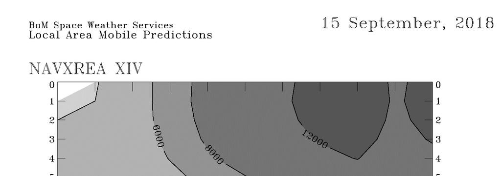
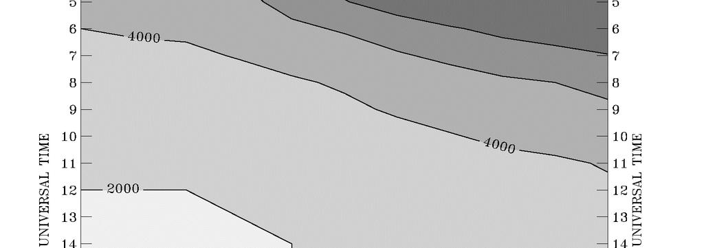
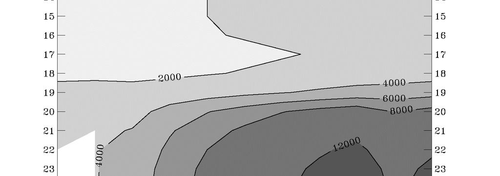
5 III GENEAL NOTICES ENC/ECDIS DATA PESENTATION AND PEFOMANCE CHECK IN SHIPS The International Maritime Organization (IMO) has recently indicated its concerns about operating anomalies identified in some ECDIS that fail to display important new chart features. The International Hydrographic Organization (IHO) has produced an ENC Data Presentation and Performance Check dataset that allows mariners to check their ECDIS. The check dataset is available through ENC service providers and from the IHO website ( which includes instructions. Mariners are strongly recommended to use the dataset and report the results of their checks to help the IHO identify how the different brands of ECDIS display and handle chart information. Mariners are asked to also inform the IMO, national Hydrographic Offices, ECDIS manufacturers and others, so that they can take any corrective action that may be necessary. In order to present the most comprehensive report possible to the IMO and to further assist in resolving the issues so far identified, the IHO is keen that as many ships as possible forward their results. eports on the results can be sent via a form provided with the data or the results can be submitted on-line through a web-form. All relevant documentation can be downloaded free from the IHO website at: ANNOUNCEMENT FO NOTICES TO MAINES USES From this edition of Notices to Mariners (Edition 15/18 dated ), there are changes to the general layout and organisation of the fortnightly publication that you have previously received. The main changes are: Section II contains product announcements (e.g. new charts, publications). Section III contains information that does not refer to any specific nautical publication. Section IV contains the Notices to Mariners that affect NZ charts. Permanent chart correcting notices are not necessarily listed before temporary or preliminary (T or P) notices. Section V contains corrections to NZ nautical publications (e.g. NZ 202, NZ 204). Section VI provides a link to updates for Admiralty Publications. Section VII provides a link to NAVAEA XIV and NZ Coastal Area Z navigational warnings on the Maritime NZ website. There is no change to the content of the NtM publication; these changes are intended to make it easier to find and view the information which is important to you. If you have any questions about this please contact us at NTM@linz.govt.nz. SOUTH PACIFIC OCEAN. MAITIME SAFETY BOADCASTS - OPTIMUM /T FEQUENCIES WITHIN NAVAEA XIV The accompanying diagrams show the optimum /T calling and working frequency bands and times for navigational warnings broadcast within 1000 nautical miles of Taupo Maritime adio (ZLM) (38 50 S., E. approx.) for the period August to October
6 III 6
7 III 7
8 III ANNOUNCEMENT OF PLANNED INMASAT I-3 TO I-4 MIGATION IN
9 III 9
10 III 10
11 IV NOTICES TO MAINES Index of Charts Affected Chart No. Notices to Mariners NZ NZ NZ NZ NZ 827 (T 827) 114(T) NZ NZ NZ NZ NZ 8275 (T 8275) 114(T) 11
12 NZ 113/18 NEW ZEALAND - South Island - East Coast Kaikoura. ocks, Soundings IV 1. Chart NZ 46 [ 092/18 ] Insert 41 41'.58S.,174 14'.54E '.23S.,174 13'.92E '.94S.,174 17'.20E '.93S.,174 14'.18E. 2. Chart NZ 62 [ 026/18 ] Insert depth 4 6 enclosed by 5m contour 41 41'.58S.,174 14'.54E '.23S.,174 13'.92E '.94S.,174 17'.20E '.93S.,174 14'.18E '.56S.,173 52'.93E '.31S.,173 45'.45E. (a) 42 24'.59S.,173 41'.78E '.42S.,173 30'.83E '.04S.,173 31'.35E. Delete depth 4 close (a) above 3. Chart NZ 63 [ 072/18 ] Insert depth 4 6 enclosed by 5m contour 42 18'.31S.,173 45'.45E. (a) 42 24'.59S.,173 41'.78E '.42S.,173 30'.83E '.04S.,173 31'.35E. Delete depth 4 close (a) above (continued) 12
13 IV NZ 113/18 NEW ZEALAND - South Island - East Coast Kaikoura. ocks, Soundings (continued) 4. Chart NZ 6212 (plan, Kaikoura Peninsula) [ NE Mar 18 ] Insert (a) 42 24'.59S.,173 41'.78E '.62S.,173 42'.28E. (b) 42 24'.65S.,173 42'.01E. (c) 42 24'.94S.,173 42'.87E '.75S.,173 40'.64E '.36S.,173 35'.59E '.98S.,173 35'.01E '.42S.,173 33'.93E. Delete depth 5 4 close (a) above depth 2 1 depth 0 2 close (b) above close (c) above 5. Chart NZ 6212 (plan, Ingles Bay) [ NE Mar 18 ] Insert 42 24'.59S.,173 41'.78E. (a) 42 24'.62S.,173 42'.28E. (b) 42 24'.65S.,173 42'.01E. (c) 42 24'.94S.,173 42'.87E. Delete depth 2 5 close (a) above depth 2 1 depth 0 2 close (b) above close (c) above 6. Chart NZ 6212 (plan, South Bay) [ NE Mar 18 ] Insert (a) 42 25'.75S.,173 40'.64E. Delete depth 2 4 close (a) above ixsurvey Australia Pty Ltd, Discovery Marine Limited HITS 62/28 13
14 IV NZ 114(T)/18 KINGDOM OF TONGA Approaches to Nuku'alofa. Aids to Navigation 1. The following leading marks have been reported as missing: Position S., W S., W. Description Beacon Beacon Characteristic Q..5m4M Iso..6s9m4M 2. Mariners are advised to exercise caution when navigating in the area. Charts temporarily affected: NZ 827 (T 827), NZ 8275 (T 8275) BA Light List (Volume K): , Australian Hydrographic Office and Ministry of Infrastructure Tonga HITS 827/9 NZ 115/18 NEW ZEALAND - North Island - East Coast Whitianga Harbour. Light 1. Chart NZ 531 [ 180/17 ] Amend light to Fl.3s30m7M (a) 36 49'.61S.,175 42'.84E. Delete existing sector at light, Fl.3s30m7M: (7 ) (a) above 2. Chart NZ 5315 [ 180/17 ] Amend light to Fl.3s30m7M (a) 36 49'.61S.,175 42'.84E. Delete all existing W and sectors at light (a) above 3. Chart NZ 5316 [ 180/17 ] Amend light to Fl.3s30m7M (a) 36 49'.61S.,175 42'.84E. Delete sector at light, Fl.3s30m7M: from : W (179 ) to : W (241.4 ) existing sectors at light, Fl.3s30m7M: (7 ) W (55.4 ) (a) above (a) above 4. Chart NZ 5318 [ 180/17 ] Amend light to Fl.3s30m7M (a) 36 49'.61S.,175 42'.84E. Delete existing sector at light, Fl.3s30m7M: (7 ) (a) above NZ Light List: 3893 Waikato egional Council HITS 5316/13 14
15 IV NZ 116(T)/18 SOUTH PACIFIC OCEAN Maritime Safety Broadcasts - Optimum /T Frequencies Within NAVAEA XIV 1. Former notice NZ 89(T)/18 is cancelled. 2. Cancel this notice on receipt. Charts formerly affected: Nil Note: NZ 89(T)/18 represented a general notice affecting NAVAEA XIV egion. Please see Section III of this Notice to Mariners Edition for Optimum /T Frequencies within NAVAEA XIV for August to October 2018 Australian Government BoM Space Weather Services -/69 15
16 V COECTIONS TO NEW ZEALAND PUBLICATIONS NEW ZEALAND NAUTICAL ALMANAC 2018/19, NZ 204 LIGHT LIST INFOMATION Whitianga Entrance Whakapenui Point Fl 3s 30 7 White Mast 5 fl 0.3. Vis (241.4 ). Partially obscured by Motukorure Island * * * * (HITS 5316/13) 16
17 VI COECTIONS TO ADMIALTY PUBLICATIONS The New Zealand Hydrographic Authority no longer publishes corrections to Admiralty Publications as part of the fortnightly New Zealand Notice to Mariners Edition. For information regarding these publications please refer to: VII NAVIGATIONAL WANINGS The New Zealand Hydrographic Authority no longer publishes navigational warnings for NAVAEA XIV and NZ Coastal Area Z as part of the fortnightly New Zealand Notice to Mariners Edition. New Zealand navigational warnings are available at: Australian navigational warnings are available at: As these lists may not be up to date it is not an authoritative source of navigational warnings so Masters/Captains are still required to receive navigational warnings from the appropriate International Maritime Organization (IMO) or World Meteorological Organization (WMO) approved Global Maritime Distress and Safety System (GMDSS) broadcast service i.e. the International SafetyNET system. 17
18 HYDOGAPHIC NOTE (For instructions, see next page) New Zealand Hydrographic Authority Land Information New Zealand adio New Zealand House 155 The Terrace PO Box 5501 Wellington 6145 New Zealand Tel: or +64 (0) Date... ef. No.... Name and address of ship or sender Tel/Fax/Telex/ of sender General locality Subject Position. Lat.... Long.... Position fixing system used Datum Paper Chart/ENC affected... Edition... Dated... Latest Notice to Mariners held Publications affected (Edition No. and date of latest supplement, page no., ID no. etc)... Details: A replacement copy of Chart No is required (see Instruction 4). Signature of observer/reporter
19 HYDOGAPHIC NOTE Forwarding Information for Charts and Hydrographic Publications Note: An acknowledgement of receipt will be sent and the information then used to the best advantage, which may mean immediate action or inclusion in a revision in due course. When a Notices to Mariners is issued, the sender s ship or name is quoted as authority unless (as sometimes happens) the information is also received in a foreign Notices to Mariners. An explanation of the use of contributions from all parts of the world would be too greater task and a further communication should only be expected when the information is of outstanding value or has unusual features. INSTUCTIONS: 1. Mariners are requested to notify New Zealand Hydrographic Authority, Land Information New Zealand, 155 The Terrace, PO Box 5501, Wellington 6145, New Zealand, when new or suspected dangers to navigation are discovered, changes observed in aids to navigation, or corrections to publications seem to be necessary. The Admiralty publication, The Mariner s Handbook (NP100), Chapter 4, gives general instructions. 2. This form and its instructions have been designed to help both the sender and the recipient. It should be used, or followed, closely, whenever appropriate. Copies of this form may be obtained gratis from the New Zealand Hydrographic Authority at the address above, or in PDF format directly from the LINZ website, Hydrographic Notes can also be sent from mobile devices using the Hydrographic Notes Application available for Android and Apple devices. 3. When a position is defined by sextant angles or bearings (true or magnetic being specified) more than two should be used in order to provide a check. Distances observed by radar should be quoted. However, when there is a series of fixes along a ship s course, only the method of fixing and the objects used need to be indicated. Latitude and longitude should only be used specifically to position the details when they have been fixed by astronomical observations or GPS and a full description of the method, equipment and datum used should be given. 4. Paper Charts: A cutting from the largest scale paper chart is the best medium for forwarding details, the alterations and additions being shown thereon in red. When requested, a new copy will be sent in replacement of a chart that has been used to forward information, or when extensive observations have involved defacement of the observer s chart. If it is preferred to show the amendments on a tracing of the largest scale chart (rather than the chart itself) these should be in red as above, but adequate detail from the chart must be traced in black ink to enable the amendments to be fitted correctly. Electronic Navigational Charts (ENCs): A screen dump of the largest scale usage band ENC with the alterations and additions being shown thereon in red. 5. When soundings are obtained, The Mariners Handbook (NP100) should be consulted. The echo sounding trace should be marked with times, depths, etc., and forwarded with the report. It is important to state whether the echo sounder is set to register depths below the surface, or below the keel; in the latter case the vessel s draught should be given. Time and date should be given in order that corrections for the height of the tide may be made where necessary. The make, name, and type of echo sounder set should also be given. 6. Modern echo sounders frequently record greater depths than the set s nominal range, e.g. with a set whose maximum is 500m a trace appearing at 50m may in fact be 550m or even 1,050m. Erroneous deep soundings beyond the sets nominal range can usually be recognised by the following: (a) The trace being weaker than normal for the depth registered (b) The trace appearing to pass through the transmission line (c) The feathery nature of the trace. 7. eports which cannot be confirmed or are lacking in certain details should not be withheld. Shortcomings should be stressed and any firm expectation of being able to check the information on a succeeding voyage should be mentioned. 8. eports of shoal soundings, uncharted dangers and navigational aids out of order should, at the mariner s discretion, also be made by radio to the nearest coast radio station. The draught of modern tankers is such that any uncharted depth under 30 metres or 15 fathoms may be of sufficient importance to justify a radio message. 19
NEW ZEALAND NOTICES TO MARINERS
 NEW ZEALAND NOTICES TO MARINERS Notice NZ 133 133 Published fortnightly by the New Zealand Hydrographic Authority Crown Copyright 2018. All rights reserved. Permission is not required to make analogue
NEW ZEALAND NOTICES TO MARINERS
 NEW ZEALAND NOTICES TO MARINERS Notices NZ 147-148 Published fortnightly by the New Zealand Hydrographic Authority Crown Copyright 2018. All rights reserved. Permission is not required to make analogue
NEW ZEALAND NOTICES TO MARINERS
 NEW ZEALAND NOTICES TO MARINERS Notices NZ 20-23 Published fortnightly by the New Zealand Hydrographic Authority Crown Copyright 2019. All rights reserved. Permission is not required to make analogue copies
NEW ZEALAND NOTICES TO MARINERS
 NEW ZEALAND NOTICES TO MARINERS Notices NZ 29-32 Published fortnightly by the New Zealand Hydrographic Authority Crown Copyright 2019. All rights reserved. Permission is not required to make analogue copies
NEW ZEALAND NOTICES TO MARINERS
 NEW ZEALAND NOTICES TO MARINERS Notices NZ 24-28 Published fortnightly by the New Zealand Hydrographic Authority Crown Copyright 2019. All rights reserved. Permission is not required to make analogue copies
NEW ZEALAND CHARTING AND NOTICES TO MARINERS
 General Information 1. In accordance with agreements between New Zealand, Australia (AUS) and the British Admiralty (BA) for reducing duplication in charting activities, New Zealand has a defined Charting
MARITIME SAFETY INFORMATION
 Introduction 1. Maritime Safety Information (MSI) is defined as navigational and meteorological warnings, meteorological forecasts, and other urgent safety-related messages. This information is of vital
IMO/IHO World-wide Navigational Warning Service (WWNWS)
") IMO/IHO World-wide Navigational Warning Service (WWNWS) 1 WWNWS 1972 PROPOSAL TO SET UP AN Ad Hoc IHO/IMO COMMITTEE TO DEVELOP AN INTER- NATIONALLY CO-ORDINATED SYSTEM FOR PROMULGATING LONG RANGE NAVIGATIONAL
IMO/IHO World-wide Navigational Warning Service (WWNWS) 1 WWNWS 1972 PROPOSAL TO SET UP AN Ad Hoc IHO/IMO COMMITTEE TO DEVELOP AN INTER- NATIONALLY CO-ORDINATED SYSTEM FOR PROMULGATING LONG RANGE NAVIGATIONAL
RESOLUTION MSC.278(85) (adopted on 1 December 2008) ADOPTION OF THE NEW MANDATORY SHIP REPORTING SYSTEM "OFF THE COAST OF PORTUGAL - COPREP"
 (adopted on 1 December 2008) ADOPTION OF THE NEW MANDATORY SHIP REPORTING SYSTEM OFF THE COAST OF PORTUGAL - COPREP") MSC 85/26/Add.1 RESOLUTION MSC.278(85) SYSTEM OFF THE COAST OF PORTUGAL COPREP THE MARITIME SAFETY COMMITTEE, RECALLING Article 28 of the Convention on the International Maritime Organization concerning
MSC 85/26/Add.1 RESOLUTION MSC.278(85) SYSTEM OFF THE COAST OF PORTUGAL COPREP THE MARITIME SAFETY COMMITTEE, RECALLING Article 28 of the Convention on the International Maritime Organization concerning
PROMULGATION OF MARITIME SAFETY INFORMATION UNDER THE GLOBAL MARITIME DISTRESS AND SAFETY SYSTEM ROY SOLURI DIRECTOR (AMERICAS) MARINEWORKS LTD
 MARINEWORKS LTD") PROMULGATION OF MARITIME SAFETY INFORMATION UNDER THE GLOBAL MARITIME DISTRESS AND SAFETY SYSTEM ROY SOLURI DIRECTOR (AMERICAS) MARINEWORKS LTD MARITIME SAFETY INFORMATION AS DEFINED IN THE SOLAS CONVENTION
PROMULGATION OF MARITIME SAFETY INFORMATION UNDER THE GLOBAL MARITIME DISTRESS AND SAFETY SYSTEM ROY SOLURI DIRECTOR (AMERICAS) MARINEWORKS LTD MARITIME SAFETY INFORMATION AS DEFINED IN THE SOLAS CONVENTION
WWNWS10/2/1-XV Meeting July 2018 Agenda Item 2.1. MSI Self Assessment NAVAREA XV - Chile. Submitted by Chile
 WWNWS WWNWS10/2/1-XV Meeting 10 27 July 2018 Agenda Item 2.1 MSI Self Assessment NAVAREA XV - Chile Submitted by Chile Executive Summary: Overview of activities undertaken within NAVAREA XV since WWNWS-9
ECDIS ENC Accuracy. Contents. Introduction LOSS PREVENTION BRIEFING FOR NORTH MEMBER SHIPS / MAY Introduction... 1
 LOSS PREVENTION BRIEFING FOR NORTH MEMBER SHIPS / MAY 2017 ECDIS ENC Accuracy Contents Introduction... 1 ECDIS Specific Familiarisation... 2 IHO S-57... 2 ENC Data Source... 2 CATZOC and M_QUAL... 2 CATZOC
Meeting 3 10 August 2011 Agenda Item 3.2. MSI Self Assessment NAVAREA X. Submitted by Australia SUMMARY
 WWNWS WWNWS3/3/2-X Meeting 3 10 August 2011 Agenda Item 3.2 MSI Self Assessment NAVAREA X Submitted by Australia SUMMARY Executive Summary: Annual report of NAVAREA X MSI activities for the period July
SOUTH AFRICAN NOTICE TO MARINERS NOVEMBER / DECEMBER 2003 EDITION
 Notices 74-79 Supplied Gratis SOUTH AFRICAN NOTICE TO MARINERS NOVEMBER / DECEMBER 2003 EDITION PUBLISHED MONTHLY BY THE HYDROGRAPHIC OFFICE CAPE TOWN I II III IV V VI CONTENTS Explanatory Notes and Index
THE ELECTRONIC CHART DISPLAY AND INFORMATION SYSTEM (ECDIS) IN CHINA
 IN CHINA") International Hydrographic 'Review, Monaco, LXIX(2), September 1992 THE ELECTRONIC CHART DISPLAY AND INFORMATION SYSTEM (ECDIS) IN CHINA by The Research Group on ECDIS 1 Abstract This paper presents a
International Hydrographic 'Review, Monaco, LXIX(2), September 1992 THE ELECTRONIC CHART DISPLAY AND INFORMATION SYSTEM (ECDIS) IN CHINA by The Research Group on ECDIS 1 Abstract This paper presents a
e-navigation Progress and trends: the IHO perspective
 International Hydrographic Organization e-navigation Progress and trends: the IHO perspective Gilles Bessero Director, IHO International Hydrographic Organization Intergovernmental consultative and technical
DEVELOPMENT OF A DEFINITION FOR MSPS AND CONSIDERATION FOR THE HARMONIZATION OF THE FORMAT AND STRUCTURE OF MSPS
 INTERNATIONAL HYDROGRAPHIC ORGANIZATION E IMO/IHO HARMONIZATION GROUP ON DATA MODELLING Agenda item 5 15 September 2017 ENGLISH ONLY DEVELOPMENT OF A DEFINITION FOR MSPS AND CONSIDERATION FOR THE HARMONIZATION
AMENDMENTS TO RESOLUTION A.706(17) WORLD-WIDE NAVIGATIONAL WARNING SERVICE
 WORLD-WIDE NAVIGATIONAL WARNING SERVICE") E 4 ALBERT EMBANKMENT LONDON SE1 7SR Telephone: +44 (0)20 7735 7611 Fax: +44 (0)20 7587 3210 AMENDMENTS TO RESOLUTION A.706(17) WORLD-WIDE NAVIGATIONAL WARNING SERVICE MSC.1/Circ.1288/Rev.1 24 June 2013
E 4 ALBERT EMBANKMENT LONDON SE1 7SR Telephone: +44 (0)20 7735 7611 Fax: +44 (0)20 7587 3210 AMENDMENTS TO RESOLUTION A.706(17) WORLD-WIDE NAVIGATIONAL WARNING SERVICE MSC.1/Circ.1288/Rev.1 24 June 2013
IHO Colours & Symbols Maintenance Working Group (C&SMWG) 15th Meeting, BSH, Rostock, Germany, 2-4 May 2005
 15th Meeting, BSH, Rostock, Germany, 2-4 May 2005") CSMWG15-INF2 IHO Colours & Symbols Maintenance Working Group (C&SMWG) 15th Meeting, BSH, Rostock, Germany, 2-4 May 2005 Ref: HA405/004/033-01 NOTE: this is an internal document of the UKHO and is supplied
CSMWG15-INF2 IHO Colours & Symbols Maintenance Working Group (C&SMWG) 15th Meeting, BSH, Rostock, Germany, 2-4 May 2005 Ref: HA405/004/033-01 NOTE: this is an internal document of the UKHO and is supplied
DRAFT ASSEMBLY RESOLUTION A. (26)
") DRAFT ASSEMBLY RESOLUTION A. (26) PROMULGATION OF MARITIME SAFETY INFORMATION The ASSEMBLY, RECALLING Article 15(j) of the Convention on the International Maritime Organization concerning the functions
DRAFT ASSEMBLY RESOLUTION A. (26) PROMULGATION OF MARITIME SAFETY INFORMATION The ASSEMBLY, RECALLING Article 15(j) of the Convention on the International Maritime Organization concerning the functions
1 st MEETING OF THE IHO COUNCIL
 C1-3.1 1 st MEETING OF THE IHO COUNCIL Monaco, 17-19 October 2017 REPORT OF THE IHO HYDROGRAPHIC SERVICES AND STANDARDS COMMITTEE C1-3.1 - P a g e 3 REPORT OF THE HYDROGRAPHIC STANDARDS AND SERVICES COMMITTEE
THIS CIRCULAR LETTER REQUIRES YOU TO VOTE. IHB File No. S3/8151/CHRIS CIRCULAR LETTER 93/ November 2008
 THIS CIRCULAR LETTER REQUIRES YOU TO VOTE IHB File No. S3/8151/CHRIS CIRCULAR LETTER 93/2008 17 November 2008 REVIEW OF IHO TECHNICAL RESOLUTIONS BY THE COMMITTEE ON HYDROGRAPHIC REQUIREMENTS FOR INFORMATION
When not communicating with other stations, all VHF radios should be switched on and set to channel 16.
 USING THE MARITIME RADIO SERVICE Instructions The details of correct radio procedure are contained in a publication by Maritime New Zealand called Radio Handbook for Coastal Vessels. This should be consulted
FOREWORD. IHO S-100 Working Group
 IHO International Hydrographic Organization KHOA Korea Hydrographic and Oceanographic Agency MUCH MORE THAN JUST NAUTICAL CHARTS IHO UNIVERSAL HYDROGRAPHIC data MODEL This document was produced with the
M5/M24 NAVIGATION EXERCISES AUS 252 NAME:
 M5/M24 NAVIGATION EXERCISES AUS 252 NAME: Use chart Aus 252 extract. Use the deviation card at end of this paper. EXERCISE NO. 1 CHART INFORMATION Select Chart Aus252 and answer the following. 1 Find the
BookletChart. Sacramento River Andrus Island to Sacramento NOAA Chart A reduced-scale NOAA nautical chart for small boaters
 BookletChart Sacramento River Andrus Island to Sacramento NOAA Chart 18662 A reduced-scale NOAA nautical chart for small boaters When possible, use the full-size NOAA chart for navigation. Included Area
The Notices to Mariners (NMs) listed below apply to the latest edition of SC5622 (3 rd Edition) published on 4 th January 2018.
 listed below apply to the latest edition of SC5622 (3 rd Edition) published on 4 th January 2018.") SC5622 Ireland South Coast The Notices to Mariners (NMs) listed below apply to the latest edition of SC5622 (3 rd Edition) published on 4 th January 2018. Temporary/Preliminary NMs L3652(P)/17 IRELAND
SC5622 Ireland South Coast The Notices to Mariners (NMs) listed below apply to the latest edition of SC5622 (3 rd Edition) published on 4 th January 2018. Temporary/Preliminary NMs L3652(P)/17 IRELAND
REVISED QUESTIONNAIRE ON SHORE-BASED FACILITIES FOR THE GLOBAL MARITIME DISTRESS AND SAFETY SYSTEM (GMDSS)
") E 4 ALBERT EMBANKMENT LONDON SE1 7SR Telephone: +44 (0)20 7735 7611 Fax: +44 (0)20 7587 3210 MSC.1/Circ.1382/Rev.2 24 June 2013 REVISED QUESTIONNAIRE ON SHORE-BASED FACILITIES FOR THE GLOBAL MARITIME DISTRESS
E 4 ALBERT EMBANKMENT LONDON SE1 7SR Telephone: +44 (0)20 7735 7611 Fax: +44 (0)20 7587 3210 MSC.1/Circ.1382/Rev.2 24 June 2013 REVISED QUESTIONNAIRE ON SHORE-BASED FACILITIES FOR THE GLOBAL MARITIME DISTRESS
Questionnaire about the Depiction of the Quality of the Data in Nautical Charts
 Questionnaire about the Depiction of the Quality of the Data in Nautical Charts Your answers to this questionnaire, to be returned to the UKHO (see details on last page), will remain anonymous unless you
INTERNATIONAL STANDARD
 INTERNATIONAL STANDARD IEC 61924 First edition 2006-05 Maritime navigation and radiocommunication equipment and systems Integrated navigation systems Operational and performance requirements, methods of
RADIO AIDS TO MARINE NAVIGATION (Pacific and Western Arctic) CANADIAN COAST GUARD. Marine Communications and Traffic Services. Annual Edition 2007
 CANADIAN COAST GUARD. Marine Communications and Traffic Services. Annual Edition 2007") RADIO AIDS TO MARINE NAVIGATION (Pacific and Western Arctic) CANADIAN COAST GUARD Marine Communications and Traffic Services Annual Edition 2007 IMPORTANT This publication is revised on a monthly basis
RADIO AIDS TO MARINE NAVIGATION (Pacific and Western Arctic) CANADIAN COAST GUARD Marine Communications and Traffic Services Annual Edition 2007 IMPORTANT This publication is revised on a monthly basis
BookletChart. Approaches to Cap-Haitien and Bahia de Monti Cristi NGA Chart A reduced-scale NGA nautical chart for small boaters
 BookletChart Approaches to Cap-Haitien and Bahia de Monti Cristi NGA Chart 26142 A reduced-scale NGA nautical chart for small boaters When possible, use the full-size NGA chart or Electronic Nautical Chart
SECTION III NM 24/15 MARINE INFORMATION
 SECTION III NM 24/15 MARINE INFORMATION NATIONAL GEOSPATIAL-INTELLIGENCE AGENCY'S (NGA) GUIDANCE ON THE PROPER DISPLAY SCALE OF DIGITAL NAUTICAL CHART (DNC) DATA The DNC portfolio was originally created
INTERNATIONAL STANDARD
 INTERNATIONAL STANDARD IEC 61174 Second edition 2001-10 Maritime navigation and radiocommunication equipment and systems Electronic chart display and information system (ECDIS) Operational and performance
UNITED KINGDOM NATIONAL REPORT
 UNITED KINGDOM NATIONAL REPORT TO THE 10 TH MACHC HYDROGRAPHIC COMMISSION MEETING Barbados 4 5 th November 2009 This report supplements the UK Generic National Report 2009, posted on the UKHO website (www.ukho.gov.uk),
This circular summarizes the various important aspects of the LRIT system with a view to enabling companies to ensure compliance in a timely manner.
 Luxembourg, 29/10/2008 CIRCULAR CAM 02/2008 N/Réf. : AH/63353 Subject : Long-Range Identification and Tracking of Ships (LRIT) To : All ship owners, ship operators and designated persons of Luxembourg
The Present Status of Small Scale ENC Coverage with Respect to the Allocation of cells to Usage Bands 1 (Overview) and 2 (General).
 and 2 (General).") CHRIS19-06.1E 19 th CHRIS MEETING Rotterdam, Netherlands, 5-9 November 2007 The Present Status of Small Scale ENC Coverage with Respect to the Allocation of cells to Usage Bands 1 (Overview) and 2 (General).
CHRIS19-06.1E 19 th CHRIS MEETING Rotterdam, Netherlands, 5-9 November 2007 The Present Status of Small Scale ENC Coverage with Respect to the Allocation of cells to Usage Bands 1 (Overview) and 2 (General).
AMENDMENTS TO RESOLUTION A.705(17) PROMULGATION OF MARITIME SAFETY INFORMATION
 PROMULGATION OF MARITIME SAFETY INFORMATION") E 4 ALBERT EMBANKMENT LONDON SE1 7SR Telephone: +44 (0)20 7735 7611 Fax: +44 (0)20 7587 3210 AMENDMENTS TO RESOLUTION A.705(17) PROMULGATION OF MARITIME SAFETY INFORMATION MSC.1/Circ.1287/Rev.1 24 June
E 4 ALBERT EMBANKMENT LONDON SE1 7SR Telephone: +44 (0)20 7735 7611 Fax: +44 (0)20 7587 3210 AMENDMENTS TO RESOLUTION A.705(17) PROMULGATION OF MARITIME SAFETY INFORMATION MSC.1/Circ.1287/Rev.1 24 June
Meeting 10 8 August 2018 Agenda Item 2.1. MSI Self Assessment NAVAREA XVI. Submitted by PERÚ - DIRECTORATE OF HYDROGRAPHY AND NAVIGATION SUMMARY
 WWNWS10 WWNWS10/2/1-XVI Meeting 10 8 August 2018 Agenda Item 2.1 MSI Self Assessment NAVAREA XVI Submitted by PERÚ - DIRECTORATE OF HYDROGRAPHY AND NAVIGATION SUMMARY Executive Summary: Report of activities
UPDATING THE ELECTRONIC CHART THE SEATRANS PROJECT
 International Hydrographic Review, Monaco, LXV II(2), July 1990 UPDATING THE ELECTRONIC CHART THE SEATRANS PROJECT by Robert SANDVIK (*) Abstract As a follow-up of the North Sea Project, which called for
CPRNW. WWNWS9/3/3/3.2 Meeting 9 20 July 2017 Agenda Item Joint MET/NAVAREA XVII and XVIII Client Survey
 CPRNW WWNWS WWNWS9/3/3/3.2 Meeting 9 20 July 2017 Agenda Item 3.3.3.2 Joint MET/NAVAREA XVII and XVIII Client Survey Submitted by Canada, NAVAREA XVII_XVIII SUMMARY Executive Summary: This document describes
MESOAMERICAN AND CARIBBEAN HYDROGRAPHIC COMMISSION 11 th Meeting, Paramaribo, Suriname, Novembro NATIONAL REPORT BRAZIL
 Page 1 of 5 MESOAMERICAN AND CARIBBEAN HYDROGRAPHIC COMMISSION 11 th Meeting, Paramaribo, Suriname, Novembro 8-12 2010 NATIONAL REPORT BRAZIL 1. Hydrographic Office / Service: Directorate of Hydrography
Meeting 3 1 August 2011 Agenda Item 3.2. MSI Self Assessment NAVAREA I. Submitted by United Kingdom SUMMARY
 WWNWS WWNWS3/3/2-I Meeting 3 1 August 2011 Agenda Item 3.2 MSI Self Assessment NAVAREA I Submitted by United Kingdom SUMMARY Executive Summary: Overview of activities undertaken within NAVAREA I since
Service instance description for the Baltic Navigational Warning Service
 Service instance description for the Baltic Navigational Warning Service 2018-01-18 Document status Authors Name Björn Andreasson Mikael Olofsson Organisation Swedish Maritime Administration Swedish Maritime
IMO RESOLUTION A.1001(25) Adopted on 29 November 2007 (Agenda item 9)
 Adopted on 29 November 2007 (Agenda item 9)") INTERNATIONAL MARITIME ORGANIZATION E IMO ASSEMBLY 25th session Agenda item 9 A 25/Res.1001 3 January 2008 Original: ENGLISH RESOLUTION A.1001(25) Adopted on 29 November 2007 (Agenda item 9) CRITERIA FOR
INTERNATIONAL MARITIME ORGANIZATION E IMO ASSEMBLY 25th session Agenda item 9 A 25/Res.1001 3 January 2008 Original: ENGLISH RESOLUTION A.1001(25) Adopted on 29 November 2007 (Agenda item 9) CRITERIA FOR
Passages Between Acklins Island, Haiti and Caicos Islands NGA Chart A reduced-scale NGA nautical chart for small boaters
 BookletChart Passages Between Acklins Island, Haiti and Caicos Islands NGA Chart 26260 A reduced-scale NGA nautical chart for small boaters When possible, use the full-size NGA chart or Electronic Nautical
SECTION III NM 4/16 MARINE INFORMATION
 MARINE INFORMATION NOAA CHART NEW EDITIONS AND THEIR AVAILABILITY NOAA produces nautical chart products to support Federal chart carriage requirements. These nautical charts are available as Print on Demand
NAVIGA TIONAL VIGA WARNINGS/MSI/GMDSS N NAV NA AREA III VIII
 NAVIGATIONAL WARNINGS/MSI/GMDSS IN NAVAREA VIII 5/16/2008 1 SCOPE OF PRESENTATION 1. Introduction 2. Navarea VIII Radio Warnings 3. Indian Notices to Mariners 4. Implementation of GMDSS 5. Marine Safety
INTERNATIONAL STANDARD
 INTERNATIONAL STANDARD IEC 60936-2 First edition 1998-10 Maritime navigation and radiocommunication equipment and systems Radar Part 2: Shipborne radar for high-speed craft (HSC) Methods of testing and
BookletChart. Intracoastal Waterway Grassy Key to Bahia Honda Key NOAA Chart A reduced-scale NOAA nautical chart for small boaters
 BookletChart Intracoastal Waterway Grassy Key to Bahia Honda Key NOAA Chart 11453 A reduced-scale NOAA nautical chart for small boaters When possible, use the full-size NOAA chart for navigation. Published
BookletChart. Cap-Haitien NGA Chart A reduced-scale NGA nautical chart for small boaters
 BookletChart Cap-Haitien NGA Chart 26146 A reduced-scale NGA nautical chart for small boaters When possible, use the full-size NGA chart or Electronic Nautical Chart (ENC) for navigation. VHF Marine Radio
NOAA s National Ocean Service / Office of Coast Survey
 Coast Survey OCS 1807 2007 Maintains over 1000 nautical charts & 9 Coast Pilots Surveys over 3.4M SNM of oceans and lakes Conducts research and development in hydrography Thomas Jefferson Founder of The
RESOLUTION MSC.230(82) (adopted on 5 December 2006) ADOPTION OF AMENDMENTS TO THE EXISTING MANDATORY SHIP REPORTING SYSTEM "IN THE STOREBÆLT (GREAT
 (adopted on 5 December 2006) ADOPTION OF AMENDMENTS TO THE EXISTING MANDATORY SHIP REPORTING SYSTEM IN THE STOREBÆLT (GREAT") MSC 82/24/Add.2 RESOLUTION MSC.230(82) MANDATORY SHIP REPORTING SYSTEM IN THE STOREBÆLT (GREAT BELT) TRAFFIC AREA THE MARITIME SAFETY COMMITTEE, RECALLING Article 28(b) of the Convention on the International
MSC 82/24/Add.2 RESOLUTION MSC.230(82) MANDATORY SHIP REPORTING SYSTEM IN THE STOREBÆLT (GREAT BELT) TRAFFIC AREA THE MARITIME SAFETY COMMITTEE, RECALLING Article 28(b) of the Convention on the International
GUIDELINES ON THE DESIGN AND USE OF PORTABLE PILOT UNITS INTERNATIONAL MARITIME PILOTS ASSOCIATION
 GUIDELINES ON THE DESIGN AND USE OF PORTABLE PILOT UNITS INTERNATIONAL MARITIME PILOTS ASSOCIATION WITH TECHNICAL INPUT FROM Comité International Radio-Maritime (CIRM) 2 FOREWORD With the increasing use
Myanmar Naval Hydrographic Centre. National Report for 13 th North Indian Ocean Hydrographic Commission Meeting
 Myanmar Naval Hydrographic Centre National Report for 13 th North Indian Ocean Hydrographic Commission Meeting Yangon, Myanmar 19 th 22 nd February 2013 CONTENT 1. Myanmar Naval Hydrographic Centre 2.
Appendix: References and glossary
 Appendix: References and glossary Facts about electronic charts and carriage requirements 2nd edition 2007 V/1 CONTENTS OF SECTION 5 Appendix: References and glossary References...................................................
dkart Navigator 9010
 dkart Navigator 9010 dkart Navigator - purpose dkart Navigator is an electronic navigation chart system specially designed to facilitate all the navigational tasks of mariner's day-to-day practice. Along
MEDITERRANEAN AND BLACK SEAS HYDROGRAPHIC COMMISSION
 MEDITERRANEAN AND BLACK SEAS HYDROGRAPHIC COMMISSION XVIII CONFERENCE CONTRIBITION BY MALTA Istanbul, Turkey 25-27 September 2013 1 Item 1 Hydrographic Office Transport Malta is responsible for all transport
UNITED KINGDOM NATIONAL REPORT
 SAIHC12-5.3K UNITED KINGDOM NATIONAL REPORT 12 TH SOUTHERN AFRICA AND ISLANDS HYDROGRAPHIC COMMISSION (SAIHC) MEETING Dar es Salaam, Tanzania 22 nd 23 rd September 2015 This report supplements the UK Generic
The Pros and Cons of using ECDIS as Primary Means of Navigation
 Sections 1 2 Company introduction The PROS of Using ECDIS and ENCs 3 The CONS of Using ECDIS and ENCs 4 Why we have choose NAVTOR Company Introduction Corporate Overview. is a Ship Management Company established
BookletChart. Port-au-Prince (Haiti) NGA Chart A reduced-scale NGA nautical chart for small boaters
 NGA Chart A reduced-scale NGA nautical chart for small boaters") BookletChart Port-au-Prince (Haiti) NGA Chart 26186 A reduced-scale NGA nautical chart for small boaters When possible, use the full-size NGA chart or Electronic Nautical Chart (ENC) for navigation. VHF
BookletChart Port-au-Prince (Haiti) NGA Chart 26186 A reduced-scale NGA nautical chart for small boaters When possible, use the full-size NGA chart or Electronic Nautical Chart (ENC) for navigation. VHF
GUIDANCE FOR THE PRESENTATION AND DISPLAY OF AIS APPLICATION-SPECIFIC MESSAGES INFORMATION
 E 4 ALBERT EMBANKMENT LONDON SE1 7SR Telephone: +44 (0)20 7735 7611 Fax: +44 (0)20 7587 3210 Ref. T2-OSS/2.7.1 SN.1/Circ.290 2 June 2010 GUIDANCE FOR THE PRESENTATION AND DISPLAY OF AIS APPLICATION-SPECIFIC
ROUTEING OF SHIPS, SHIP REPORTING AND RELATED MATTERS. Establishment of a Mandatory Ship Reporting System in the
 INTERNATIONAL MARITIME ORGANIZATION E SUB-COMMITTEE ON SAFETY OF NAVIGATION 48th session Agenda item 3 IMO NAV 48/3/2 11 April 2002 Original: ENGLISH ROUTEING OF SHIPS, SHIP REPORTING AND RELATED MATTERS
BRIEF - NAVAREA IX INTROCUCTION/BACK GROUND
 BRIEF - NAVAREA IX INTROCUCTION/BACK GROUND 1. NAVAREA IX is one of the 16 areas established through the Worldwide Navigational Warning Service (WWNWS). It consists of Northwest Arabian Sea, the Gulfand
GPS & DGPS Made Easy
 NOTE GPS & DGPS Made Easy This booklet is intended to provide mariners with a basic understanding of the Global Positioning System (GPS) and the Differential Global Positioning System (DGPS), and to assist
HYDROGRAPHIC SURVEY STANDARDS AND DELIVERABLES
 TABLE OF CONTENTS 1. HYDROGRAPHIC SURVEY METHODOLOGY... 3 2. HYDROGRAPHIC SURVEY REFERENCE STANDARDS... 3 3. HYDROGRAPHIC SURVEY CRITERIA... 3 3.1 HYDROGRAPHIC SURVEYS OVER NON GAZETTED NAVIGABLE WATERS*:...
AAPSilver System Performance Validation
 Report No. CG-D-04-13 AAPSilver System Performance Validation Distribution Statement A: Approved for public release; distribution is unlimited. 1 N O T I C E This document is disseminated under the sponsorship
PAPUA NEW GUINEA HYDROGRAPHIC SERVICE
 PAPUA NEW GUINEA HYDROGRAPHIC SERVICE IHO SOUTH WEST PACIFIC HYDROGRAPHIC COMMISSION (SWPHC) 9 th Meeting Port Moresby, Papua New Guinea, 10-11 March 2007 SWPHC9-01PNG 1. INTRODUCTION 9 th SOUTH WEST PACIFIC
IMO ACTIVITIES AFFECTING HSSC
 HSSC1-04.2A rev3 1 st HSSC MEETING Singapore, 22-24 October 2009 Paper for Consideration by HSSC IMO ACTIVITIES AFFECTING HSSC Submitted by: Executive Summary: Related Documents: IHB This paper summarizes
Paper for Consideration by S-100WG3. Report on S-100 Sea trial of KHOA
 S-100WG3-8.1 Paper for Consideration by S-100WG3 Report on S-100 Sea trial of KHOA Submitted by: Executive Summary: Related Documents: Related Projects: Republic of Korea (KHOA) This paper reports the
SECTION III NM 35/10 MARINE INFORMATION NOAA CHART NEW EDITIONS AND THEIR AVAILABILITY
 SECTION III NM 35/10 MARINE INFORMATION NOAA CHART NEW EDITIONS AND THEIR AVAILABILITY NOAA recognizes two paper nautical chart products: - the Print-on-Demand (POD) chart distributed by OceanGrafix (www.oceangrafix.com),
Paper for Consideration by SNPWG. [Radio Services Product Specification Sample data sets]
![Paper for Consideration by SNPWG. [Radio Services Product Specification Sample data sets]](/thumbs/72/67892905.jpg "Paper for Consideration by SNPWG. [Radio Services Product Specification Sample data sets]") SNPWG 17-9 Paper for Consideration by SNPWG [Radio Services Product Specification Sample data sets] Submitted by: Executive Summary: Related Documents: Related Projects: FRANCE The Jusslandian List of
SNPWG 17-9 Paper for Consideration by SNPWG [Radio Services Product Specification Sample data sets] Submitted by: Executive Summary: Related Documents: Related Projects: FRANCE The Jusslandian List of
SECTION III NM 39/13 MARINE INFORMATION NGA CHART NEW EDITIONS AND THEIR AVAILABILITY
 SECTION III NM 39/13 MARINE INFORMATION NGA CHART NEW EDITIONS AND THEIR AVAILABILITY NGA standard nautical hardcopy chart products are made available and distributed by three different authorized methods:
SECTION III NM 32/13 MARINE INFORMATION NOAA CHART NEW EDITIONS AND THEIR AVAILABILITY
 MARINE INFORMATION NOAA CHART NEW EDITIONS AND THEIR AVAILABILITY NOAA recognizes two paper nautical chart products: Print-on-Demand (POD) and traditional paper charts. - Print-on-Demand (POD) charts are
UNITED KINGDOM NATIONAL REPORT
 Page 1 of 9 UNITED KINGDOM NATIONAL REPORT TO THE 11 th MEETING OF THE MESO AMERICAN AND CARIBBEAN SEA HYDROGRAPHIC COMMISSION Paramaribo, Suriname 8 th 12 th November 2010 NOTE: This report supplements
RESOLUTION MSC.229(82) (adopted on 5 December 2006) ADOPTION OF A NEW MANDATORY SHIP REPORTING SYSTEM "IN THE GALAPAGOS PARTICULARLY SENSITIVE SEA
 (adopted on 5 December 2006) ADOPTION OF A NEW MANDATORY SHIP REPORTING SYSTEM IN THE GALAPAGOS PARTICULARLY SENSITIVE SEA") MSC 82/24/Add.2 RESOLUTION MSC.229(82) IN THE GALAPAGOS PARTICULARLY SENSITIVE SEA AREA (PSSA) (GALREP) THE MARITIME SAFETY COMMITTEE, RECALLING Article 28(b) of the Convention on the International Maritime
MSC 82/24/Add.2 RESOLUTION MSC.229(82) IN THE GALAPAGOS PARTICULARLY SENSITIVE SEA AREA (PSSA) (GALREP) THE MARITIME SAFETY COMMITTEE, RECALLING Article 28(b) of the Convention on the International Maritime
Contract Specifications for Paper Hydrographic Charts, Version 1.2, July 2009
 Contract Specifications for Paper Hydrographic Charts, Version 1.2, July 2009 Note: These contract specifications have been developed from CHARTspec Version 3.1. Changes to this are detailed in the Record
CHART STANDARDIZATION & PAPER CHART WORKING GROUP (CSPCWG)
") INTERNATIONAL HYDROGRAPHIC ORGANIZATION ORGANISATION HYDROGRAPHIQUE INTERNATIONALE CHART STANDARDIZATION & PAPER CHART WORKING GROUP (CSPCWG) [A Working Group of the Committee on Hydrographic Requirements
INTERNATIONAL HYDROGRAPHIC ORGANIZATION ORGANISATION HYDROGRAPHIQUE INTERNATIONALE CHART STANDARDIZATION & PAPER CHART WORKING GROUP (CSPCWG) [A Working Group of the Committee on Hydrographic Requirements
ROUTEING OF SHIPS, SHIP REPORTING AND RELATED MATTERS. New traffic separation schemes and two-way routes in Norra Kvarken
 E SUB-COMMITTEE ON SAFETY OF NAVIGATION 57th session Agenda item 3 NAV 57/3/7 11 March 2011 Original: ENGLISH ROUTEING OF SHIPS, SHIP REPORTING AND RELATED MATTERS New traffic separation schemes and two-way
PROGRESS UPDATE AND FUTURE DIRECTIONS OF THE MARINE ELECTRONIC HIGHWAY (MEH)
") PROGRESS UPDATE AND FUTURE DIRECTIONS OF THE MARINE ELECTRONIC HIGHWAY (MEH) BACKGROUND 1. The Marine Electronic Highway Demonstration Project (MEH DP) was a 4- year regional project in the Straits of
PROGRESS UPDATE AND FUTURE DIRECTIONS OF THE MARINE ELECTRONIC HIGHWAY (MEH) BACKGROUND 1. The Marine Electronic Highway Demonstration Project (MEH DP) was a 4- year regional project in the Straits of
The Automatic Identification System operating jointly with radar as the aid to navigation
 Scientific Journals Maritime University of Szczecin Zeszyty Naukowe Akademia Morska w Szczecinie 2013, 36(108) z. 1 pp. 156 161 2013, 36(108) z. 1 s. 156 161 ISSN 1733-8670 The Automatic Identification
Ufs. No Notices to Mariners, SWEDEN Swedish Maritime Administration.
 Ufs No 528 2015-01-08 Notices to Mariners, SWEDEN Swedish Maritime Administration Editorial office Swedish Maritime Administration Ufs/BALTICO 601 78 NORRKÖPING Sweden tel: 0771 630 605 e-mail: ufs@sjofartsverket.se
Universidad Nacional Experimental Marítima del Caribe Vicerrectorado Académico Cátedra de Idiomas Inglés VI. Ingeniería Marítima
 Universidad Nacional Experimental Marítima del Caribe Vicerrectorado Académico Cátedra de Idiomas Inglés VI. Ingeniería Marítima UNIT II. Navigational equipment found onboard ships. Speaking. 1. Can you
MSI Self Assessment NAVAREA V. Submitted by BRAZIL SUMMARY. Executive Summary: NAVAREA V provides the paper of MSI Self Assessment for PRNW1 (WWNWS1)
") WWNWS WWNWS1/3/2/V Meeting 1 16 July 2009 Agenda Item 3.2 MSI Self Assessment NAVAREA V Submitted by BRAZIL SUMMARY Executive Summary: NAVAREA V provides the paper of MSI Self Assessment for PRNW1 (WWNWS1)
WWNWS WWNWS1/3/2/V Meeting 1 16 July 2009 Agenda Item 3.2 MSI Self Assessment NAVAREA V Submitted by BRAZIL SUMMARY Executive Summary: NAVAREA V provides the paper of MSI Self Assessment for PRNW1 (WWNWS1)
National Marine Electronics Association International Marine Electronics Association. Technical Bulletin
 National Marine Electronics Association International Marine Electronics Association Technical Bulletin Amendment to NMEA 0183 Version 4.10 # AT 0183 20130815 NMEA 0183 Amendment An amendment is a technical
SECTION III NM 15/12 MARINE INFORMATION
 SECTION III NM 15/12 MARINE INFORMATION CHANGES TO BROADCAST OF WEATHER FORECASTS FOR THE OFFSHORE SOUTHWEST NORTH ATLANTIC, CARIBBEAN, AND GULF OF MEXICO Effective Tuesday April 03, 2012 at 2:00 pm Eastern
National Report of Finland
 National Report of Finland [31 August 2010] Executive Summary This Report gives an overview of the main activities of the Finnish Hydrographic Office (FHO) since the previous BSHC 14 th Conference. The
REVISED JOINT IMO/IHO/WMO MANUAL ON MARITIME SAFETY INFORMATION (MSI)
") INTERNATIONAL MARITIME ORGANIZATION 4 ALBERT EMBANKMENT LONDON SE1 7SR Telephone: 020 7735 7611 Fax: 020 7587 3210 IMO E Ref. T2-OSS/1.4 MSC.1/Circ.1310 8 June 2009 REVISED JOINT IMO/IHO/WMO MANUAL ON
INTERNATIONAL MARITIME ORGANIZATION 4 ALBERT EMBANKMENT LONDON SE1 7SR Telephone: 020 7735 7611 Fax: 020 7587 3210 IMO E Ref. T2-OSS/1.4 MSC.1/Circ.1310 8 June 2009 REVISED JOINT IMO/IHO/WMO MANUAL ON
Ref: CS05/320/F December 2005
 Ref: CS05/320/F510-511-530-480 20 December 2005 To: 406 MHz Beacon Manufacturers, Agents & Developers, C-S Beacon Type Approval Test Facilities, Beacon Component Manufacturers, Cc: International Civil
This Privacy Policy describes the types of personal information SF Express Co., Ltd. and
 Effective Date: 2017/05/10 Updated date: 2017/05/25 This Privacy Policy describes the types of personal information SF Express Co., Ltd. and its affiliates (collectively as "SF") collect about consumers
SECTION III NM 17/15 MARINE INFORMATION
 SECTION III NM 17/15 MARINE INFORMATION NOAA CHART NEW EDITIONS AND THEIR AVAILABILITY NOAA produces nautical chart products to support Federal chart carriage requirements. These nautical charts are available
AS/NZS : MHz satellite distress beacons AS/NZS :2003
 AS/NZS 4280.1:2003 (Incorporating Amendment Nos 1, 2, 3 and 4) Australian/New Zealand Standard 406 MHz satellite distress beacons Part 1: Marine emergency position-indicating radio beacons (EPIRB) (IEC
Extent of Consultation
 Objective Parts 40A, 40C and 40D prescribe design, construction and equipment requirements for passenger ships that are not SOLAS ships, non-passenger ships that are not SOLAS ships and fishing ships.
Baie de L Acul and Approaches (Haiti) NGA Chart A reduced-scale NGA nautical chart for small boaters
 NGA Chart A reduced-scale NGA nautical chart for small boaters") BookletChart Baie de L Acul and Approaches (Haiti) NGA Chart 26148 A reduced-scale NGA nautical chart for small boaters When possible, use the full-size NGA chart or Electronic Nautical Chart (ENC) for
BookletChart Baie de L Acul and Approaches (Haiti) NGA Chart 26148 A reduced-scale NGA nautical chart for small boaters When possible, use the full-size NGA chart or Electronic Nautical Chart (ENC) for
Production of Electronic Chart using updated survey data for EL-Arish harbor
 ARAB ACADEMY FOR SCIENCE AND TECHNOLOGY AND MARITIME TRANSPORT Alexandria, Egypt Production of Electronic Chart using updated survey data for EL-Arish harbor Submitted By ASHRAF NABIL HASSAN EL-ASSAL B.SC.
THE IHO, ELECTRONIC CHARTING AND THE CHANGING RELATIONSHIP TO PORTS
 International Hydrographic Review, Monaco, LXXI(2), September 1994 THE IHO, ELECTRONIC CHARTING AND THE CHANGING RELATIONSHIP TO PORTS by Rear Admiral Christian ANDREASEN1 (Presented at European Harbour
The Notices to Mariners (NMs) listed below apply to the latest edition of SC5612 (3rd Edition) published on 28 th July 2016.
 listed below apply to the latest edition of SC5612 (3rd Edition) published on 28 th July 2016.") Admiralty Leisure Folio SC5612 Northern Ireland The Notices to Mariners (NMs) listed below apply to the latest edition of SC5612 (3rd Edition) published on 28 th July 2016. L2080(P)/14 IRISH SEA England
Admiralty Leisure Folio SC5612 Northern Ireland The Notices to Mariners (NMs) listed below apply to the latest edition of SC5612 (3rd Edition) published on 28 th July 2016. L2080(P)/14 IRISH SEA England
RADIO AIDS TO MARINE NAVIGATION (Atlantic, St. Lawrence, Great Lakes, Lake Winnipeg and Eastern Arctic) CANADIAN COAST GUARD
 CANADIAN COAST GUARD") RADIO AIDS TO MARINE NAVIGATION (Atlantic, St Lawrence, Great Lakes, Lake Winnipeg and Eastern Arctic) CANADIAN COAST GUARD Marine Communications and Traffic Services Annual Edition 2006 IMPORTANT This
RADIO AIDS TO MARINE NAVIGATION (Atlantic, St Lawrence, Great Lakes, Lake Winnipeg and Eastern Arctic) CANADIAN COAST GUARD Marine Communications and Traffic Services Annual Edition 2006 IMPORTANT This
Digital broadcasting systems under development within ITU-R of interest for the maritime community
 Digital broadcasting systems under development within ITU-R of interest for the maritime community Christian RISSONE ANFR rissone@anfr.fr IHO, WWNWS 5 Monaco, 2 nd October 2013 1 Background for the 500
SOME OBSERVATIONS ON THE USE OF GPS AND CHARTS
 International Hydrographic Review, Monaco, LXX(2), September 1993 SOME OBSERVATIONS ON THE USE OF GPS AND CHARTS by D. SIMPSON 1 INTRODUCTION The purpose of this paper is to bring to the attention of chart