The Present Status of Small Scale ENC Coverage with Respect to the Allocation of cells to Usage Bands 1 (Overview) and 2 (General).
|
|
|
- Peregrine Dominic Dennis
- 6 years ago
- Views:
Transcription
1 CHRIS E 19 th CHRIS MEETING Rotterdam, Netherlands, 5-9 November 2007 The Present Status of Small Scale ENC Coverage with Respect to the Allocation of cells to Usage Bands 1 (Overview) and 2 (General). Introduction (Tony Pharaoh IHB) The concept of separating ENCs into usage bands provides data producers with a mechanism to create cells designed for six distinct navigational purposes, each having different levels of content (e.g. contour intervals) and degrees of generalization. Similar Navigational Purposes (see table 1 below) are also used for paper chart series. Subfield content ENC Navigational purpose 1 overview 2 general 3 coastal 4 approach 5 harbour 6 berthing Table 1 The observations presented below are based on the supposition that most ENCs have been derived from paper charts and therefore have similar characteristics in terms of their content, generalization and, (to a lesser extent) coverage. As it was not possible to determine the scales of ENC source data, a combination of the Compilation Scale and cell size have been used to estimate the scale of source data. It is assumed that an ENCs Compilation Scale (CSCALE) is comparable its source chart scale and its cells limits approximate those of the source paper chart. The scales chosen for port approach, harbour and berthing paper charts, are largely dependent on factors such as the available source data, the size of the harbour and the extent of the port area. As these factors vary from port to port, the scales and chart coverage may vary accordingly. Similarly coastal charts (usage band 3) also need to take into account additional factors such as the nature of coastal area and density of shipping. Consequently the scales and extents chosen for these charts may also vary from area to area. Small scale charts and ENC cells often extend beyond national charting limits and provide extensive coverage of the high seas. Their content is usually reduced to significant navigational features, and is often highly generalized. The compilations scales chosen for these products are not as heavily influenced by littoral coastal conditions and therefore provide an opportunity for the development of harmonized, consistent word wide chart coverage. This has been achieved for paper charts and has been implemented within the framework of the small scale INT chart series. These charts are based on a common set of specifications and have harmonized scales, content and presentation. This does not however appear to be the case for small scale ENCs. The intention of this paper is to present the status of small scale ENC production, and to highlight some inconsistencies that may be undermining efforts to achieve harmonized consistent small scale coverage.
2 The ENC cell limits shown in the diagrams below were obtained from the IC-ENC web site and show ENCs that are available from IC-ENC and Primar Stavanger.
3 Guidance on Allocating Small Scale ENC to Appropriate Usage Bands The S-57 ENC Product Specification does not provide guidance on the appropriate scales ranges to be used for each of the 6 Navigational Purposes, however some advice is provided in IHO publication S-65 and the SCAMIN Paper approved by the 16 th CHRIS meeting. Both propose that there should be a correlation between scale range and navigational purpose as shown in the table below. (From the SCAMIN Paper in the TSMAD web page). Usage Bands HOs must assign each ENC to a usage band based on the ENC s compilation scale and determined by the following ranges: ) Furthermore S-65 states that: The inter-relationship and interaction between usage bands, SCAMIN and compilation scale are particularly problematic and it is difficult (impossible?) to formulate voluntary guidelines that resolve all of the problems and that are acceptable to all HOs with differing views of these issues. Not withstanding the above, it is proposed that better guidance and coordination is needed for small scale ENCs of Usage Bands 1 and 2. As these cells often cover international water and are not influenced by local coastal conditions to the same extent as larger scale national ENCs, guidance is needed to ensure better harmonization with respect to the source data used, the selection of appropriate compilation scales, and cell coverage/extent schemes. It is recommended that this should take account of existing IHO specifications for small scale INT charts, and should be coordinated by Regional Hydrographic Commissions. This is consistent with WEND Principle 2.4 which states that The INT chart system is a useful basis for initial area selection for producing ENC and INT chart ranges. IHO publication M-11, Section C describes small scale INT charts as: Two schemes of international (INT) charts on scales of 1: and smaller, that have been established under the auspices of the International Hydrographic Bureau (IHB). These charts have been designed to provide complete and comprehensive small-scale coverage, usable by all nations, for the world s oceans. Present Status of Small Scale ENC Coverage ENCs assigned to usage band 1 have compilation scales (CSCALE) values that range between 1: and 1: In Figure 1 below, all Navigational Purpose 1 cells shown in red have CSCALE set to a value between and whereas for those shown in black, CSCALE is set to a value between and Cells assigned to Navigational Purpose 2 are shown in yellow.
.")

4 Figure 1 - Navigational Purpose 1 (Cells with CSCALE set to a value between and are shown in red). Figure 2 below shows Navigational Purpose 2 ENC coverage. Cells with CSCALE set to a value between and are shown in red. Figure 2 - Navigational Purpose 2 (Cells with CSCALE set to a value between and are shown in red). Table 2 shows the number of cells allocated to NP1 and NP 2 usage bands in slightly finer granularity. Scale Ranges Cells assigned to Navigational Purpose 1 Navigational Purpose 2 1: to 1: cells 0 cells 1: to 1: : to 1: : to 1: : to 1: : to 1: : to 1: : to 1: : to 1: Table 2
5 Conclusion. It is evident from Table 2 above that ENC producers have different perceptions about the allocation of cells to usage bands 1 and 2. Assuming that the CSCALE value and the coverage limits (shown in the diagram above) provide an indication of the scale of the source chart(s) used, it must be concluded that there are large variances in the degree of generalization between cells assigned to usage band 1. It is proposed that this will frustrate attempts to achieve display consistency, through the harmonization of CSCALE and the application of SCAMIN. Unless ENCs assigned to usage band 1 are based on charts that have similar scales (and similar levels generalization), it is proposed that the recommendations outlined in CHRIS paper (CHRIS C - Recommendations for Consistent ENC Data Encoding) will not be affective in certain areas. A second issue relating overlapping data also needs to be highlighted. The S-57 ENC Product Specification states that Cells with the same navigational purpose may overlap. However, data within the cells must not overlap (Section Cells). For large scale usage bands this can be easily managed as most (or all) ENC cells fall within a producer s national charting area. This is not the case for small scale usage bands. For example ENC producer state A may produce a navigational purpose 1 ENC based on a 1: INT chart that covers the coast areas of producer states B, C and D. These producer states may also be in the process of producing navigational purpose 1 cells based on larger scale charts. Whenever one of these (larger scale) cells is issued, it will be necessary to revise the 1: cell in order to remove the content (data) for the area covered by the new cell. As producer nations increasingly allocate national ENC cells to usage bands 1 and 2, the maintenance task associated with existing small scale (INT) cells will increase exponentially. Recommendations. It is proposed that WEND Principal 2.4 ( The INT chart system is a useful basis for initial area selection for producing ENCs ) be applied more rigorously for the assignment of ENC to usage band 1 (Overview). Furthermore it is suggested that Regional Hydrographic Commissions assume the responsibility for the planning, production and maintenance of Navigational Purpose 1 cells. The allocation of cells to usage band 1 should be the prerogative of RHCs, whereas usage bands 2 to 6 should be available for national ENC production. If this is considered for implementation, Regional Hydrographic Commissions will need to take note of WEND Principal 2.3 (b), which states: 2.3 By the dates established by IMO, Member States will strive to either: a. Provide the necessary ENC coverage, or b. Agree with other States to produce the necessary ENC coverage on their behalf. IHO will address overall coverage on a regional basis through Regional Hydrographic Commissions. Figure 3 below was presented to the 8 th South West Pacific Hydrographic meeting which took place in Papeete, French Polynesia between the18 and 21 September It illustrates the Australian Hydrographic Offices production scheme for Navigational Purpose 1 ENCs and demonstrates how small scale ENC production could be coordinated on a regional basis.
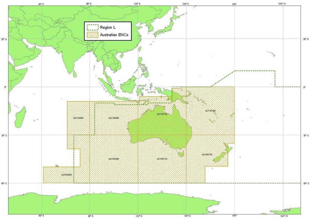
6 Figure 3
ENC Status Regions F & G
 ENC Status Regions F & G -31Jan-2Feb 2017 REGION F ICC WG STATUS OF THE ENC SCHEME 2 ENC UB 1 STATUS (OVERVIEW) SOURCE: PRIMAR.ORG (2017) NO1A3000 IT100360 HR100010 UA1F0005 UA1F0006 TR100010 GR1OVER1
A guideline for establishing feature and symbol standard management system for national HOs
 A guideline for establishing feature and symbol standard management system for national HOs Joint 26th TSMAD and 5th DIPWG Meeting Silver Spring, Maryland, USA(10-14 June 2013) Republic of Korea (ROK)
USE OF THE RCDS MODE OF ECDIS (Submissions by Australia and Norway to IMO MSC/78)
") IHB File No. S3/8152 CIRCULAR LETTER 21/2004 22 March 2004 USE OF THE RCDS MODE OF ECDIS (Submissions by Australia and Norway to IMO MSC/78) Ref: 1. WEND Letter 1/2004, dated 1 st February 2004 2. IMO
IHB File No. S3/8152 CIRCULAR LETTER 21/2004 22 March 2004 USE OF THE RCDS MODE OF ECDIS (Submissions by Australia and Norway to IMO MSC/78) Ref: 1. WEND Letter 1/2004, dated 1 st February 2004 2. IMO
1 st MEETING OF THE IHO COUNCIL
 C1-3.1 1 st MEETING OF THE IHO COUNCIL Monaco, 17-19 October 2017 REPORT OF THE IHO HYDROGRAPHIC SERVICES AND STANDARDS COMMITTEE C1-3.1 - P a g e 3 REPORT OF THE HYDROGRAPHIC STANDARDS AND SERVICES COMMITTEE
17 th CHRIS Meeting Rostock, Germany, 5-9 September Report of IHO-IEC Harmonization Group on Marine Information Objects (HGMIO
 17 th CHRIS Meeting Rostock, Germany, 5-9 September 2004 CHRIS17-7A rev.1 Report of IHO-IEC Harmonization Group on Marine Information Objects (HGMIO Lee Alexander, University of New Hampshire (Chair, HGMIO)
Production of Electronic Chart using updated survey data for EL-Arish harbor
 ARAB ACADEMY FOR SCIENCE AND TECHNOLOGY AND MARITIME TRANSPORT Alexandria, Egypt Production of Electronic Chart using updated survey data for EL-Arish harbor Submitted By ASHRAF NABIL HASSAN EL-ASSAL B.SC.
e-navigation Progress and trends: the IHO perspective
 International Hydrographic Organization e-navigation Progress and trends: the IHO perspective Gilles Bessero Director, IHO International Hydrographic Organization Intergovernmental consultative and technical
11 th CHRIS MEETING IHB, Monaco, November Draft - - -
 CHRIS/11/16A 11 th CHRIS MEETING IHB, Monaco, 16-18 November 1999 - - - Draft - - - Workshop on Development of Marine Information Objects (MIO) for ECDIS Burlington, Ontario, Canada 8-9 November 1999 Record
Appendix: References and glossary
 Appendix: References and glossary Facts about electronic charts and carriage requirements 2nd edition 2007 V/1 CONTENTS OF SECTION 5 Appendix: References and glossary References...................................................
MESOAMERICAN AND CARIBBEAN HYDROGRAPHIC COMMISSION 11 th Meeting, Paramaribo, Suriname, Novembro NATIONAL REPORT BRAZIL
 Page 1 of 5 MESOAMERICAN AND CARIBBEAN HYDROGRAPHIC COMMISSION 11 th Meeting, Paramaribo, Suriname, Novembro 8-12 2010 NATIONAL REPORT BRAZIL 1. Hydrographic Office / Service: Directorate of Hydrography
ECDIS ENC Accuracy. Contents. Introduction LOSS PREVENTION BRIEFING FOR NORTH MEMBER SHIPS / MAY Introduction... 1
 LOSS PREVENTION BRIEFING FOR NORTH MEMBER SHIPS / MAY 2017 ECDIS ENC Accuracy Contents Introduction... 1 ECDIS Specific Familiarisation... 2 IHO S-57... 2 ENC Data Source... 2 CATZOC and M_QUAL... 2 CATZOC
FOREWORD. IHO S-100 Working Group
 IHO International Hydrographic Organization KHOA Korea Hydrographic and Oceanographic Agency MUCH MORE THAN JUST NAUTICAL CHARTS IHO UNIVERSAL HYDROGRAPHIC data MODEL This document was produced with the
GUIDANCE FOR THE PRESENTATION AND DISPLAY OF AIS APPLICATION-SPECIFIC MESSAGES INFORMATION
 E 4 ALBERT EMBANKMENT LONDON SE1 7SR Telephone: +44 (0)20 7735 7611 Fax: +44 (0)20 7587 3210 Ref. T2-OSS/2.7.1 SN.1/Circ.290 2 June 2010 GUIDANCE FOR THE PRESENTATION AND DISPLAY OF AIS APPLICATION-SPECIFIC
DEVELOPMENT OF A DEFINITION FOR MSPS AND CONSIDERATION FOR THE HARMONIZATION OF THE FORMAT AND STRUCTURE OF MSPS
 INTERNATIONAL HYDROGRAPHIC ORGANIZATION E IMO/IHO HARMONIZATION GROUP ON DATA MODELLING Agenda item 5 15 September 2017 ENGLISH ONLY DEVELOPMENT OF A DEFINITION FOR MSPS AND CONSIDERATION FOR THE HARMONIZATION
World-Wide Navigational Warning Service Sub-Committee WWNWS-5 Monaco, 1-4 October S-100 Basics Background Brief
 International Hydrographic Organization World-Wide Navigational Warning Service Sub-Committee WWNWS-5 Monaco, 1-4 October 2013 S-100 Basics Background Brief Gilles Bessero 15:29 1 S-100 Basics S-100 -
Nordic Hydrographic Commission 60th Conference - Stavanger - Norway April New national ENC service for leisure craft users
 Nordic Hydrographic Commission 60th Conference - Stavanger - Norway 11-13 April 2016 New national ENC service for leisure craft users New national ENC service for leisure craft users The aim of the new
National Report of Finland
 National Report of Finland [31 August 2010] Executive Summary This Report gives an overview of the main activities of the Finnish Hydrographic Office (FHO) since the previous BSHC 14 th Conference. The
IHO S-100 FRAMEWORK - BASELINE STANDARD FOR E- NAVIGATION MARITIME SERVICES
 UNDERWAY (24 26 January 2018) IHO S-100 FRAMEWORK - BASELINE STANDARD FOR E- NAVIGATION MARITIME SERVICES Abri Kampfer Director, IHO Copenhagen, Denmark (24 26 January 2018) What is the?. intergovernmental
56 th NHC Meeting May 21-23, 2012 Copenhagen, Denmark. Draft Minutes. [May 23, 2012]
![56 th NHC Meeting May 21-23, 2012 Copenhagen, Denmark. Draft Minutes. [May 23, 2012]](/thumbs/91/107654306.jpg "56 th NHC Meeting May 21-23, 2012 Copenhagen, Denmark. Draft Minutes. [May 23, 2012]") NHC/56 Draft Minutes 56 th NHC Meeting May 21-23, 2012 Copenhagen, Denmark Draft Minutes [May 23, 2012] Venue: Chair: Secretary: Participants: The Danish Royal Academy of Sciences and Letters, Klasseværelset
NHC/56 Draft Minutes 56 th NHC Meeting May 21-23, 2012 Copenhagen, Denmark Draft Minutes [May 23, 2012] Venue: Chair: Secretary: Participants: The Danish Royal Academy of Sciences and Letters, Klasseværelset
The ship RV Timba repairs are now almost complete and it is expected that come September 2014 the ship will be fully operational.
 Malawi National Report 2014 1 Malawi Hydrographic Office The assembly of the 70 ton ship RV Timba with the assistance of the French government in 1989 ushered in the commencement of modern hydrographic
IMO/IHO World-wide Navigational Warning Service (WWNWS)
") IMO/IHO World-wide Navigational Warning Service (WWNWS) 1 WWNWS 1972 PROPOSAL TO SET UP AN Ad Hoc IHO/IMO COMMITTEE TO DEVELOP AN INTER- NATIONALLY CO-ORDINATED SYSTEM FOR PROMULGATING LONG RANGE NAVIGATIONAL
IMO/IHO World-wide Navigational Warning Service (WWNWS) 1 WWNWS 1972 PROPOSAL TO SET UP AN Ad Hoc IHO/IMO COMMITTEE TO DEVELOP AN INTER- NATIONALLY CO-ORDINATED SYSTEM FOR PROMULGATING LONG RANGE NAVIGATIONAL
IHB File No S3/8151/HSSC CIRCULAR LETTER 11/ February 2009
 CIRCULAR LETTER 11/2009 17 February 2009 REVIEW OF IHO TECHNICAL RESOLUTIONS BY THE COMMITTEE ON HYDROGRAPHIC REQUIREMENTS FOR INFORMATION SYSTEMS (CHRIS) 1 (GROUP 1 OF 4) Reference: IHB CL 93/2008 dated
UNITED KINGDOM NATIONAL REPORT
 Page 1 of 9 UNITED KINGDOM NATIONAL REPORT TO THE 11 th MEETING OF THE MESO AMERICAN AND CARIBBEAN SEA HYDROGRAPHIC COMMISSION Paramaribo, Suriname 8 th 12 th November 2010 NOTE: This report supplements
CAPACITY BUILDING PLAN Programme document for the period
 INTERNATIONAL HYDROGRAPHIC ORGANIZATION MESO AMERICAN & CARIBBEAN SEA HYDROGRAPHIC COMMISSION 1. INTRODUCTION CAPACITY BUILDING PLAN Programme document for the period 2013-2017 1.1. Rationale It is estimated
There has been some success
 Surveying Hydrography in Africa by Captain Abri Kampfer, Hydrographer SA Navy The International Hydrographic Bureau (IHB) and many member states of the International Hydrographic Organisation (IHO) have
THIS CIRCULAR LETTER REQUIRES YOU TO VOTE. IHB File No. S3/8151/CHRIS CIRCULAR LETTER 93/ November 2008
 THIS CIRCULAR LETTER REQUIRES YOU TO VOTE IHB File No. S3/8151/CHRIS CIRCULAR LETTER 93/2008 17 November 2008 REVIEW OF IHO TECHNICAL RESOLUTIONS BY THE COMMITTEE ON HYDROGRAPHIC REQUIREMENTS FOR INFORMATION
UNITED KINGDOM NATIONAL REPORT
 UNITED KINGDOM NATIONAL REPORT TO THE 10 TH MACHC HYDROGRAPHIC COMMISSION MEETING Barbados 4 5 th November 2009 This report supplements the UK Generic National Report 2009, posted on the UKHO website (www.ukho.gov.uk),
WWNWS3/3/3/1A Meeting 3 1 August 2011 Agenda Item NAVTEX Panel Report SUMMARY
 WWNWS WWNWS3/3/3/1A Meeting 3 1 August 2011 Agenda Item 3.3.1 NAVTEX Panel Report Submitted by Chair, IMO International NAVTEX Co-ordinating Panel SUMMARY Executive Summary: This report provides a summary
BSICCWG Report to the BSHC 23 rd Conference
 23 rd BSHC Conference Agenda Item D.2 27-29 August 2018 BSICCWG Report Aalborg, Denmark Finland Baltic Sea International Charting Coordination Working Group (BSICCWG) BSICCWG Report to the BSHC 23 rd Conference
THE IHO, ELECTRONIC CHARTING AND THE CHANGING RELATIONSHIP TO PORTS
 International Hydrographic Review, Monaco, LXXI(2), September 1994 THE IHO, ELECTRONIC CHARTING AND THE CHANGING RELATIONSHIP TO PORTS by Rear Admiral Christian ANDREASEN1 (Presented at European Harbour
MBSHC (Mediterranean and Black Seas Hydrographic Commission) XVII. conference, Greece Jun. 2011
 XVII. conference, Greece Jun. 2011") MBSHC (Mediterranean and Black Seas Hydrographic Commission) XVII. conference, Greece 01. 03. Jun. 2011 National report of SLOVENIA 01. May 2011 MBSHC report - SLOVENIA 1 0 Index 0 Index... 2 1 Hydrographic
MBSHC (Mediterranean and Black Seas Hydrographic Commission) XVII. conference, Greece 01. 03. Jun. 2011 National report of SLOVENIA 01. May 2011 MBSHC report - SLOVENIA 1 0 Index 0 Index... 2 1 Hydrographic
RESOLUTION MSC.278(85) (adopted on 1 December 2008) ADOPTION OF THE NEW MANDATORY SHIP REPORTING SYSTEM "OFF THE COAST OF PORTUGAL - COPREP"
 (adopted on 1 December 2008) ADOPTION OF THE NEW MANDATORY SHIP REPORTING SYSTEM OFF THE COAST OF PORTUGAL - COPREP") MSC 85/26/Add.1 RESOLUTION MSC.278(85) SYSTEM OFF THE COAST OF PORTUGAL COPREP THE MARITIME SAFETY COMMITTEE, RECALLING Article 28 of the Convention on the International Maritime Organization concerning
MSC 85/26/Add.1 RESOLUTION MSC.278(85) SYSTEM OFF THE COAST OF PORTUGAL COPREP THE MARITIME SAFETY COMMITTEE, RECALLING Article 28 of the Convention on the International Maritime Organization concerning
A UK Voluntary Code of Practice for Unmanned Surface Vessels. Andy Higgins UK MASRWG 16 November 2017
 A UK Voluntary Code of Practice for Unmanned Surface Vessels Andy Higgins UK MASRWG 16 November 2017 A Bit of Background - UK MASRWG The UK Maritime Autonomous Systems Regulatory Working Group was formed
... Salient Ocean Issues that have arisen during 2002
 ... As reported in paragraph 62 of the resolution Oceans and the law of the seas, we are especially pleased with the focus for this meeting, given that protecting vulnerable marine ecosystems and safety
AMENDMENTS TO RESOLUTION A.705(17) PROMULGATION OF MARITIME SAFETY INFORMATION
 PROMULGATION OF MARITIME SAFETY INFORMATION") E 4 ALBERT EMBANKMENT LONDON SE1 7SR Telephone: +44 (0)20 7735 7611 Fax: +44 (0)20 7587 3210 AMENDMENTS TO RESOLUTION A.705(17) PROMULGATION OF MARITIME SAFETY INFORMATION MSC.1/Circ.1287/Rev.1 24 June
E 4 ALBERT EMBANKMENT LONDON SE1 7SR Telephone: +44 (0)20 7735 7611 Fax: +44 (0)20 7587 3210 AMENDMENTS TO RESOLUTION A.705(17) PROMULGATION OF MARITIME SAFETY INFORMATION MSC.1/Circ.1287/Rev.1 24 June
IHO Colours & Symbols Maintenance Working Group (C&SMWG) 15th Meeting, BSH, Rostock, Germany, 2-4 May 2005
 15th Meeting, BSH, Rostock, Germany, 2-4 May 2005") CSMWG15-INF2 IHO Colours & Symbols Maintenance Working Group (C&SMWG) 15th Meeting, BSH, Rostock, Germany, 2-4 May 2005 Ref: HA405/004/033-01 NOTE: this is an internal document of the UKHO and is supplied
CSMWG15-INF2 IHO Colours & Symbols Maintenance Working Group (C&SMWG) 15th Meeting, BSH, Rostock, Germany, 2-4 May 2005 Ref: HA405/004/033-01 NOTE: this is an internal document of the UKHO and is supplied
INTERNATIONAL STANDARD
 INTERNATIONAL STANDARD IEC 61174 Second edition 2001-10 Maritime navigation and radiocommunication equipment and systems Electronic chart display and information system (ECDIS) Operational and performance
SPAIN NATIONAL REPORT/ ეროვნული ანგარიში.
 SPAIN NATIONAL REPORT/ ეროვნული ანგარიში http://www.armada.mde.es/ihm. 2 Index 1. Hydrographic Offices 2. Surveys 3. Charts and updates 4. Publications and updates 5. MSI 6. C-55 7. Capacity Building 8.
NHC 59th meeting Agenda item NHC59-9A April 14-15, 2015 Reykjavik - Iceland. New national ENC service for leisure craft users
 NHC 59th meeting Agenda item NHC59-9A April 14-15, 2015 Reykjavik - Iceland New national ENC service for leisure craft users The aim of the new ENC service The aim of the new ENC service is to enhance
Myanmar Naval Hydrographic Centre. National Report for 13 th North Indian Ocean Hydrographic Commission Meeting
 Myanmar Naval Hydrographic Centre National Report for 13 th North Indian Ocean Hydrographic Commission Meeting Yangon, Myanmar 19 th 22 nd February 2013 CONTENT 1. Myanmar Naval Hydrographic Centre 2.
NEW ZEALAND NOTICES TO MARINERS
 NEW ZEALAND NOTICES TO MARINERS Notice NZ 133 133 Published fortnightly by the New Zealand Hydrographic Authority Crown Copyright 2018. All rights reserved. Permission is not required to make analogue
NEW ZEALAND CHARTING AND NOTICES TO MARINERS
 General Information 1. In accordance with agreements between New Zealand, Australia (AUS) and the British Admiralty (BA) for reducing duplication in charting activities, New Zealand has a defined Charting
Fiscal 2007 Environmental Technology Verification Pilot Program Implementation Guidelines
 Fifth Edition Fiscal 2007 Environmental Technology Verification Pilot Program Implementation Guidelines April 2007 Ministry of the Environment, Japan First Edition: June 2003 Second Edition: May 2004 Third
National Report of Finland
 National Report of Finland 1. Finnish Hydrographic Office The Finnish Hydrographic Office is organized under The Finnish Transport Agency. The Finnish Transport Agency is responsible for the Finnish roads,
ChartDatumWG Report to the BSHC 15 th Conference
 15 th BSHC Conference Agenda Item F1 21-23 September 2010 Explanatory Note Gdynia, Poland FINLAND BSHC Chart Datum Working Group ChartDatumWG Report to the BSHC 15 th Conference [10 September 2010] 1.
MONTHLY MEETING REPORTS JANUARY 2018
 8 th e-navigation Underway International Conference MS Pearl Seaways, at Sea, 24 to 26 January Contribution to the IHO Work Programme 2018 Task 2.1.6.1 E navigation Underway International 2018 The 8 th
DRAFT ASSEMBLY RESOLUTION A. (26)
") DRAFT ASSEMBLY RESOLUTION A. (26) PROMULGATION OF MARITIME SAFETY INFORMATION The ASSEMBLY, RECALLING Article 15(j) of the Convention on the International Maritime Organization concerning the functions
DRAFT ASSEMBLY RESOLUTION A. (26) PROMULGATION OF MARITIME SAFETY INFORMATION The ASSEMBLY, RECALLING Article 15(j) of the Convention on the International Maritime Organization concerning the functions
HYDROGRAPHIC SURVEY STANDARDS AND DELIVERABLES
 TABLE OF CONTENTS 1. HYDROGRAPHIC SURVEY METHODOLOGY... 3 2. HYDROGRAPHIC SURVEY REFERENCE STANDARDS... 3 3. HYDROGRAPHIC SURVEY CRITERIA... 3 3.1 HYDROGRAPHIC SURVEYS OVER NON GAZETTED NAVIGABLE WATERS*:...
PAPUA NEW GUINEA HYDROGRAPHIC SERVICE
 PAPUA NEW GUINEA HYDROGRAPHIC SERVICE IHO SOUTH WEST PACIFIC HYDROGRAPHIC COMMISSION (SWPHC) 9 th Meeting Port Moresby, Papua New Guinea, 10-11 March 2007 SWPHC9-01PNG 1. INTRODUCTION 9 th SOUTH WEST PACIFIC
Paper for Consideration by DIPWG
 TSMAD20/DIPWG2-15A Paper for Consideration by DIPWG Considerations for Symbolizing Nautical Publication Information in ECDIS Submitted by: Executive Summary: Related Documents: Related Projects: DIPWG
Meeting 3 10 August 2011 Agenda Item 3.2. MSI Self Assessment NAVAREA X. Submitted by Australia SUMMARY
 WWNWS WWNWS3/3/2-X Meeting 3 10 August 2011 Agenda Item 3.2 MSI Self Assessment NAVAREA X Submitted by Australia SUMMARY Executive Summary: Annual report of NAVAREA X MSI activities for the period July
MARITIME SAFETY INFORMATION
 Introduction 1. Maritime Safety Information (MSI) is defined as navigational and meteorological warnings, meteorological forecasts, and other urgent safety-related messages. This information is of vital
A Survey of Mariners' Opinions on Using Electronic Charts
 s i l s Note A Survey of Mariners' Opinions on Using Electronic Charts Igor Karnicnik, M.Sc., Geodetic Institute of Slovenia, Slovenia. A new component of modern shipborne navigation equipment is the Electronic
PROGRESS UPDATE AND FUTURE DIRECTIONS OF THE MARINE ELECTRONIC HIGHWAY (MEH)
") PROGRESS UPDATE AND FUTURE DIRECTIONS OF THE MARINE ELECTRONIC HIGHWAY (MEH) BACKGROUND 1. The Marine Electronic Highway Demonstration Project (MEH DP) was a 4- year regional project in the Straits of
PROGRESS UPDATE AND FUTURE DIRECTIONS OF THE MARINE ELECTRONIC HIGHWAY (MEH) BACKGROUND 1. The Marine Electronic Highway Demonstration Project (MEH DP) was a 4- year regional project in the Straits of
Evaluation IENC Usages RWS
 Ordered by Rijkswaterstaat DVS Author: P.A. Kluytenaar Rotterdam, 29 juli 2010 Serendipity UnLtd, Veerkade 15, Rotterdam Content Chapter page Summary 1. Introduction... 2 2. Approach... 3 3. Scale/ range
High precision hydrography The St. Lawrence River channel HD Bathymetry, Production, Distribution and Updating
 HYDRO12 Conference High precision hydrography The St. Lawrence River channel HD Bathymetry, Production, Distribution and Updating M. Journault, L. Maltais, and R. Sanfaçon Canadian Hydrographic Service
STATUS REPORT ON ACTIVITIES OF IMO AND IHO CONCERNING THE ELECTRONIC CHART. by Adam J. KERR (*) Background
 Background") International Hydrographic Review, Monaco, LXV11(2), July 1990 STATUS REPORT ON ACTIVITIES OF IMO AND IHO CONCERNING THE ELECTRONIC CHART by Adam J. KERR (*) This paper was presented at Oceanology International
International Hydrographic Review, Monaco, LXV11(2), July 1990 STATUS REPORT ON ACTIVITIES OF IMO AND IHO CONCERNING THE ELECTRONIC CHART by Adam J. KERR (*) This paper was presented at Oceanology International
OIML E 5 EXPERT REPORT. 6th Edition 2015 (E) ORGANISATION INTERNATIONALE INTERNATIONAL ORGANIZATION
 ORGANISATION INTERNATIONALE INTERNATIONAL ORGANIZATION") EXPERT REPORT OIML E 5 6th Edition 2015 (E) Overview of the present status of the standards referred to in OIML D 11:2013 General requirements for measuring instruments Environmental conditions Revue du
EXPERT REPORT OIML E 5 6th Edition 2015 (E) Overview of the present status of the standards referred to in OIML D 11:2013 General requirements for measuring instruments Environmental conditions Revue du
63rd Meeting of the Nordic Hydrographic Commission Meeting 9 11 April 2019, Helsinki, Finland
 Agenda item D4. Denmark 63rd Meeting of the Nordic Hydrographic Commission Meeting 9 11 April 2019, Helsinki, Finland Paper for Consideration by NHC63 Digital products for the leisure market 1. Introduction
R E P O R T. of the BSHC Working Group for the Harmonization of the Chart Datum of the Baltic Sea (CDWG)
") 12-14 June 2007 Explanatory Note Klaipeda, Lithuania R E P O R T of the BSHC Working Group for the Harmonization of the Chart Datum of the Baltic Sea (CDWG) Activities of the CDWG The CDWG was established
12-14 June 2007 Explanatory Note Klaipeda, Lithuania R E P O R T of the BSHC Working Group for the Harmonization of the Chart Datum of the Baltic Sea (CDWG) Activities of the CDWG The CDWG was established
NEW ZEALAND NOTICES TO MARINERS
 NEW ZEALAND NOTICES TO MARINERS Notices NZ 147-148 Published fortnightly by the New Zealand Hydrographic Authority Crown Copyright 2018. All rights reserved. Permission is not required to make analogue
MesoAmerican - Caribbean Sea Hydrographic Commission. International Hydrographic Organization DRAFT AGENDA DAY 1
 International Hydrographic Organization MesoAmerican-Caribbean Sea Hydrographic Commission DAY 1 DRAFT AGENDA MesoAmerican - Caribbean Sea Hydrographic Commission ELECTRONIC CHART WORKING GROUP MEETING
ECC Report 276. Thresholds for the coordination of CDMA and LTE broadband systems in the 400 MHz band
 ECC Report 276 Thresholds for the coordination of CDMA and LTE broadband systems in the 400 MHz band 27 April 2018 ECC REPORT 276 - Page 2 0 EXECUTIVE SUMMARY This Report provides technical background
E-Navigation: Opening the door to the future
 International Association of Marine Aids to Navigation and Lighthouse Authorities E-Navigation: Opening the door to the future E-Navigation Underway North America November 2018 Secretary-General Francis
REPORT. Technical Visit THE ISLAMIC REPUBLIC OF IRAN February 2007
 REPORT Technical Visit to THE ISLAMIC REPUBLIC OF IRAN 20-22 February 2007 2 Technical Visit to the Islamic Republic of Iran (IHO Work Program 2007, Tasks 2.1.7 and 2.1.10) 20-22 February 2007 I.- General
AN OVERVIEW OF THE STATE OF MARINE SPATIAL PLANNING IN THE MEDITERRANEAN COUNTRIES MALTA REPORT
 AN OVERVIEW OF THE STATE OF MARINE SPATIAL PLANNING IN THE MEDITERRANEAN COUNTRIES MALTA REPORT Malta Environment & Planning Authority May 2007 AN OVERVIEW OF THE STATE OF MARINE SPATIAL PLANNING IN THE
Revised Technical Annex Telecommunication: Coordination and Use of Radio Frequencies Above 30 Megacycles per Second
 Spectrum Management Terrestrial Radiocommunication Agreements and Arrangements Revised Technical Annex Telecommunication: Coordination and Use of Radio Frequencies Above 30 Megacycles per Second Agreement
Working Party 5B DRAFT NEW RECOMMENDATION ITU-R M.[500KHZ]
![Working Party 5B DRAFT NEW RECOMMENDATION ITU-R M.[500KHZ]](/thumbs/92/109768647.jpg "Working Party 5B DRAFT NEW RECOMMENDATION ITU-R M.[500KHZ]") Radiocommunication Study Groups Source: Subject: Document 5B/TEMP/376 Draft new Recommendation ITU-R M.[500kHz] Document 17 November 2011 English only Working Party 5B DRAFT NEW RECOMMENDATION ITU-R M.[500KHZ]
Radiocommunication Study Groups Source: Subject: Document 5B/TEMP/376 Draft new Recommendation ITU-R M.[500kHz] Document 17 November 2011 English only Working Party 5B DRAFT NEW RECOMMENDATION ITU-R M.[500KHZ]
NEW AND AMENDED TRAFFIC SEPARATION SCHEMES
 E 4 ALBERT EMBANKMENT LONDON SE1 7SR Telephone: +44 (0)20 7735 7611 Fax: +44 (0)20 7587 3210 NEW AND AMENDED TRAFFIC SEPARATION SCHEMES COLREG.2/Circ.67 20 May 2016 1 The Maritime Safety Committee, at
Frank Heymann 1.
 Plausibility analysis of navigation related AIS parameter based on time series Frank Heymann 1 1 Deutsches Zentrum für Luft und Raumfahrt ev, Neustrelitz, Germany email: frank.heymann@dlr.de In this paper
UNITED KINGDOM NATIONAL REPORT
 SAIHC12-5.3K UNITED KINGDOM NATIONAL REPORT 12 TH SOUTHERN AFRICA AND ISLANDS HYDROGRAPHIC COMMISSION (SAIHC) MEETING Dar es Salaam, Tanzania 22 nd 23 rd September 2015 This report supplements the UK Generic
Draft submission paper: Hydrographic Offices way on EMODnet. Subject : Hydrographic Offices way on EMODnet. Foreword :
 Subject : Hydrographic Offices way on EMODnet Foreword : This paper is aimed to present the state of the EMODnet project, the European Commission s policy for this project, the principles of the Hydrographic
Digital broadcasting systems under development within ITU-R of interest for the maritime community
 Digital broadcasting systems under development within ITU-R of interest for the maritime community Christian RISSONE ANFR rissone@anfr.fr IHO, WWNWS 5 Monaco, 2 nd October 2013 1 Background for the 500
MLG to MLLW Vertical Datum Conversion. Mississippi River Venice, Louisiana to the Gulf of Mexico (Vicinity of Southwest Pass) Louisiana
 Louisiana") Engineering Documentation Report EDR-OD-01 MLG to MLLW Vertical Datum Conversion Mississippi River Venice, Louisiana to the Gulf of Mexico (Vicinity of Southwest Pass) Louisiana Prepared by: US Army Corps
Engineering Documentation Report EDR-OD-01 MLG to MLLW Vertical Datum Conversion Mississippi River Venice, Louisiana to the Gulf of Mexico (Vicinity of Southwest Pass) Louisiana Prepared by: US Army Corps
IENC production at the Flemish Hydrography. HYDRO12, 15 th November 2012 Jasmine Dumollin
 IENC production at the Flemish Hydrography HYDRO12, 15 th November 2012 Jasmine Dumollin ENC versus Inland ENC Definition Inland ENC Database, standardized as to content, structure and format, for use
Future of ocean mapping, hydrography, policy and public perception
 Future of ocean mapping, hydrography, policy and public perception Mustafa IPTES Director, IHO Busan, 15 November 2017 OUTLINE Current status of Ocean Mapping Ongoing Ocean Mapping Activities New Initiatives
The Response from Motorola Ltd. to the Consultation on The Licence-Exemption Framework Review
 The Response from Motorola Ltd. to the Consultation on The Licence-Exemption Framework Review June 21 st 2007. Key Points 1. The introduction of the concept of a version of Commons in which the possible
MEDITERRANEAN AND BLACK SEAS HYDROGRAPHIC COMMISSION XVI CONFERENCE CONTRIBUTION BY CROATIA
 MEDITERRANEAN AND BLACK SEAS HYDROGRAPHIC COMMISSION XVI CONFERENCE CONTRIBUTION BY CROATIA UKRAINE, Odessa 22-24 September 2009 CONTENTS... 1 1. HYDROGRAPHIC OFFICE... 2 2. SURVEYS... 2 2.1. Survey status...
A Study on Basic VTS Guideline based on Ship s Operator s Consciousness
 http://www.transnav.eu the International Journal on Marine Navigation and Safety of Sea Transportation Volume 11 Number 4 December 2017 DOI: 10.12716/1001.11.04.04 A Study on Basic VTS Guideline based
Paper for Consideration by S-100WG3. Report on S-100 Sea trial of KHOA
 S-100WG3-8.1 Paper for Consideration by S-100WG3 Report on S-100 Sea trial of KHOA Submitted by: Executive Summary: Related Documents: Related Projects: Republic of Korea (KHOA) This paper reports the
UPDATES to the. Rules of Procedure. (Edition of 1998) approved by the Radio Regulations Board. Contents
 approved by the Radio Regulations Board. Contents") UPDATES to the Rules of Procedure (Edition of 1998) approved by the Radio Regulations Board Revision (1) (Circular No.) Date Part ARS Pages to be removed Pages to be inserted 1 June 1999 A1 ARS5 15-18
UPDATES to the Rules of Procedure (Edition of 1998) approved by the Radio Regulations Board Revision (1) (Circular No.) Date Part ARS Pages to be removed Pages to be inserted 1 June 1999 A1 ARS5 15-18
87R14 PETROLEUMEXPLORATI
 E 87R14 SA M PL COSTESTI MATECLASSI FI CATI ON SYSTEM-ASAPPLI EDFORTHE PETROLEUMEXPLORATI ONAND PRODUCTI ONI NDUSTRY AACE International Recommended Practice No. 87R-14 COST ESTIMATE CLASSIFICATION SYSTEM
Consolidation of Navigation Safety Regulations IMO - NCSR / MSC Updates
 Mariners Workshop - January 23 th and 24 th 2019: Consolidation of Navigation Safety Regulations IMO - NCSR / MSC Updates IMO UPDATE NCSR / MSC Sessions Outcome of the Navigation, Communications and Search
NAUTICAL CHARTING IN SMALLER COUNTRIES WITH SHORT COASTLINE - TROUBLES AND ADVANTAGES
 NAUTICAL CHARTING IN SMALLER COUNTRIES WITH SHORT COASTLINE - TROUBLES AND ADVANTAGES Igor KARNICNIK, M.Sc. Dalibor RADOVAN (Geodetic Institute of Slovenia, Jamova 2, Ljubljana, Slovenia; igor.karnicnik@geod-is.si)
(The Fishing Municipalities Strömstad-Tanum-Sotenäs-Lysekil-Tjörn-Göteborg-Ökerö Västra Götaland Region)
") 1(5) (The Fishing Municipalities Strömstad-Tanum-Sotenäs-Lysekil-Tjörn-Göteborg-Ökerö Västra Götaland Region) Consultation on reform of Common Fisheries Policy The Fishing Municipalities The Fishing Municipalities,
1(5) (The Fishing Municipalities Strömstad-Tanum-Sotenäs-Lysekil-Tjörn-Göteborg-Ökerö Västra Götaland Region) Consultation on reform of Common Fisheries Policy The Fishing Municipalities The Fishing Municipalities,
COMMUNICATIONS FOR MARITIME SAFETY AND EFFICIENCY. Francis Zachariae, Secretary-General, IALA
 COMMUNICATIONS FOR MARITIME SAFETY AND EFFICIENCY Francis Zachariae, Secretary-General, IALA IALA and its Purpose Non profit, international technical association established in 1957 Two Goals aimed at
The human touch in technology. ECDIS ECS Conning screen Ship speed info system
 The human touch in technology ECDIS ECS Conning screen Ship speed info system Alphatron ALPHACHART T ECDIS Type approved ECDIS system powered by TRANSAS The ALPHACHART T is an advanced Electronic Chart
EGNOS status and performance in the context of marine navigation requirements
 EGNOS status and performance in the context of marine navigation requirements J. Cydejko Gdynia Maritime University, Gdynia, Poland ABSTRACT: The current status of EGNOS (December 2006) is described as
INTERNATIONAL STANDARD
 INTERNATIONAL STANDARD IEC 61174 Edition 4.0 2015-08 colour inside Maritime navigation and radiocommunication equipment and systems Electronic chart display and information system (ECDIS) Operational and
ASIA-PACIFIC BROADCASTING UNION (ABU) POSITION ON WRC-12 AGENDA ITEMS 1.4, 1.10, 1.14, 1.15, 1.17, 1.19, 1.22 AND 1.25
 POSITION ON WRC-12 AGENDA ITEMS 1.4, 1.10, 1.14, 1.15, 1.17, 1.19, 1.22 AND 1.25") World Radiocommunication Conference (WRC-12) Geneva, 23 January - 17 February 2012 PLENARY MEETING Document E ABU-2 2011 Original: English ASIA-PACIFIC BROADCASTING UNION (ABU) POSITION ON WRC-12 AGENDA
World Radiocommunication Conference (WRC-12) Geneva, 23 January - 17 February 2012 PLENARY MEETING Document E ABU-2 2011 Original: English ASIA-PACIFIC BROADCASTING UNION (ABU) POSITION ON WRC-12 AGENDA
MARINE ELECTRONIC HIGHWAY IN STRAITS OF MALACCA AND SINGAPORE. Development of Supporting Element for Future & Sustainable Operation
 COOPERATION FORUM UNDER THE COOPERATIVE MECHANISM ON SAFETY OF NAVIGATION AND ENVIRONMENTAL PROTECTION IN THE STRAITS OF MALACCA AND SINGAPORE 7th SESSION Agenda Item... CF 7/... 22-23 September 2014 Original.
IMO RESOLUTION A.1001(25) Adopted on 29 November 2007 (Agenda item 9)
 Adopted on 29 November 2007 (Agenda item 9)") INTERNATIONAL MARITIME ORGANIZATION E IMO ASSEMBLY 25th session Agenda item 9 A 25/Res.1001 3 January 2008 Original: ENGLISH RESOLUTION A.1001(25) Adopted on 29 November 2007 (Agenda item 9) CRITERIA FOR
INTERNATIONAL MARITIME ORGANIZATION E IMO ASSEMBLY 25th session Agenda item 9 A 25/Res.1001 3 January 2008 Original: ENGLISH RESOLUTION A.1001(25) Adopted on 29 November 2007 (Agenda item 9) CRITERIA FOR
Questionnaire about the Depiction of the Quality of the Data in Nautical Charts
 Questionnaire about the Depiction of the Quality of the Data in Nautical Charts Your answers to this questionnaire, to be returned to the UKHO (see details on last page), will remain anonymous unless you
FRENCH NATIONAL REPORT TO THE 6 TH MEETING OF THE ROPME HYDROGRAPHIC COMMISSION
 Paris, January, 30th 2015 SERVICE HYDROGRAPHIQUE ET OCEANOGRAPHIQUE DE LA MARINE N 003 SHOM/DMI/REX/NP DIRECTION DES MISSIONS INSTITUTIONNELLES ET DES RELATIONS INTERNATIONALES Dossier suivi par IPETA
Meeting 3 1 August 2011 Agenda Item 3.2. MSI Self Assessment NAVAREA I. Submitted by United Kingdom SUMMARY
 WWNWS WWNWS3/3/2-I Meeting 3 1 August 2011 Agenda Item 3.2 MSI Self Assessment NAVAREA I Submitted by United Kingdom SUMMARY Executive Summary: Overview of activities undertaken within NAVAREA I since
IMO. Resolution A.954(23) Adopted on 5 December 2003 (Agenda item 17) PROPER USE OF VHF CHANNELS AT SEA
 Adopted on 5 December 2003 (Agenda item 17) PROPER USE OF VHF CHANNELS AT SEA") INTERNATIONAL MARITIME ORGANIZATION E IMO ASSEMBLY 23rd session Agenda item 17 A 23/Res.954 26 February 2004 Original: ENGLISH Resolution A.954(23) Adopted on 5 December 2003 (Agenda item 17) PROPER USE
INTERNATIONAL MARITIME ORGANIZATION E IMO ASSEMBLY 23rd session Agenda item 17 A 23/Res.954 26 February 2004 Original: ENGLISH Resolution A.954(23) Adopted on 5 December 2003 (Agenda item 17) PROPER USE
RESOLUTION MSC.230(82) (adopted on 5 December 2006) ADOPTION OF AMENDMENTS TO THE EXISTING MANDATORY SHIP REPORTING SYSTEM "IN THE STOREBÆLT (GREAT
 (adopted on 5 December 2006) ADOPTION OF AMENDMENTS TO THE EXISTING MANDATORY SHIP REPORTING SYSTEM IN THE STOREBÆLT (GREAT") MSC 82/24/Add.2 RESOLUTION MSC.230(82) MANDATORY SHIP REPORTING SYSTEM IN THE STOREBÆLT (GREAT BELT) TRAFFIC AREA THE MARITIME SAFETY COMMITTEE, RECALLING Article 28(b) of the Convention on the International
MSC 82/24/Add.2 RESOLUTION MSC.230(82) MANDATORY SHIP REPORTING SYSTEM IN THE STOREBÆLT (GREAT BELT) TRAFFIC AREA THE MARITIME SAFETY COMMITTEE, RECALLING Article 28(b) of the Convention on the International
Policy Research Corporation
 Policy Research Corporation SOUND SOLUTIONS BASED ON SCIENTIFIC RESEARCH The role of Maritime Clusters to enhance the strength and development of maritime sectors Country report Denmark INTRODUCTION TO
RESOLUTION MSC.229(82) (adopted on 5 December 2006) ADOPTION OF A NEW MANDATORY SHIP REPORTING SYSTEM "IN THE GALAPAGOS PARTICULARLY SENSITIVE SEA
 (adopted on 5 December 2006) ADOPTION OF A NEW MANDATORY SHIP REPORTING SYSTEM IN THE GALAPAGOS PARTICULARLY SENSITIVE SEA") MSC 82/24/Add.2 RESOLUTION MSC.229(82) IN THE GALAPAGOS PARTICULARLY SENSITIVE SEA AREA (PSSA) (GALREP) THE MARITIME SAFETY COMMITTEE, RECALLING Article 28(b) of the Convention on the International Maritime
MSC 82/24/Add.2 RESOLUTION MSC.229(82) IN THE GALAPAGOS PARTICULARLY SENSITIVE SEA AREA (PSSA) (GALREP) THE MARITIME SAFETY COMMITTEE, RECALLING Article 28(b) of the Convention on the International Maritime
WIA Repeater and Beacon Licence Recommendation Policy August Background
 WIA Repeater and Beacon Licence Recommendation Policy August 2014 Background The WIA provides a repeater and beacon licence recommendation service under a long- standing agreement with the ACMA. Individual