IENC production at the Flemish Hydrography. HYDRO12, 15 th November 2012 Jasmine Dumollin
|
|
|
- Arleen Smith
- 5 years ago
- Views:
Transcription


1 IENC production at the Flemish Hydrography HYDRO12, 15 th November 2012 Jasmine Dumollin

2 ENC versus Inland ENC

3 Definition Inland ENC Database, standardized as to content, structure and format, for use with inland electronic chart display and / or information systems operated on board of vessels transiting inland waterways. An IENC is issued by or on the authority of a competent government agency, and conforms to standards [initially] developed by the International Hydrographic Organization (IHO) and [refined by] the Inland ENC Harmonization Group. An IENC contains all the chart information necessary for safe navigation on inland waterways and may contain supplementary information in addition to that contained in the paper chart (e.g. sailing directions, machine-readable operating schedules, etc.) which may be considered necessary for safe navigation and voyage planning. [IENC Encoding Guide, Edition 2.2, Feb 2010] source:iehg: ienc.openecdis.org
4 Navigational purposes ENC IENC
5 Minimum Content IENC Minimum Contents of an IENC At a Minimum, the following objects shall be included in an IENC: 1. Bank of waterway 2. Shoreline construction (e.g., groin, training wall) 3. Any facility that is considered a hazard to navigation 4. Contours of locks and dams (i.e., footprint area) 5. Boundaries of the navigation channel (if defined) 6. Isolated dangers in the navigation channel that are either: a) under water (obstructions) b) above water level (e.g., bridges, overhead cables) 7. Official Aids-to-Navigation (e.g. buoys, beacons, lights, notice marks) 8. Waterway axis with kilometres/hectometres, or river miles

6 Regulatory status of Inland ENCs in Europe RIS Directive 2005/44/EC Production of IENC is required What? Waterways class Va and above including the ports on such waterways By whom? Competent authorities assigned by the MS When? within 30 months after the publication of the technical guideline for Inland Ecdis source:iehg: ienc.openecdis.org

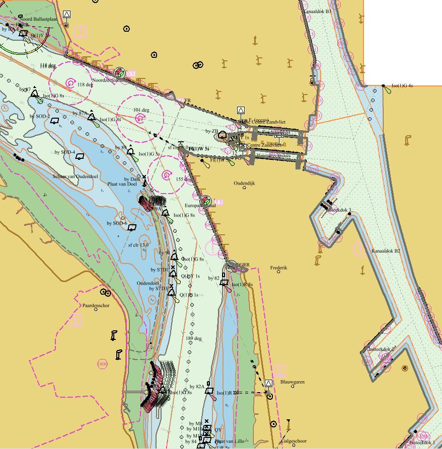
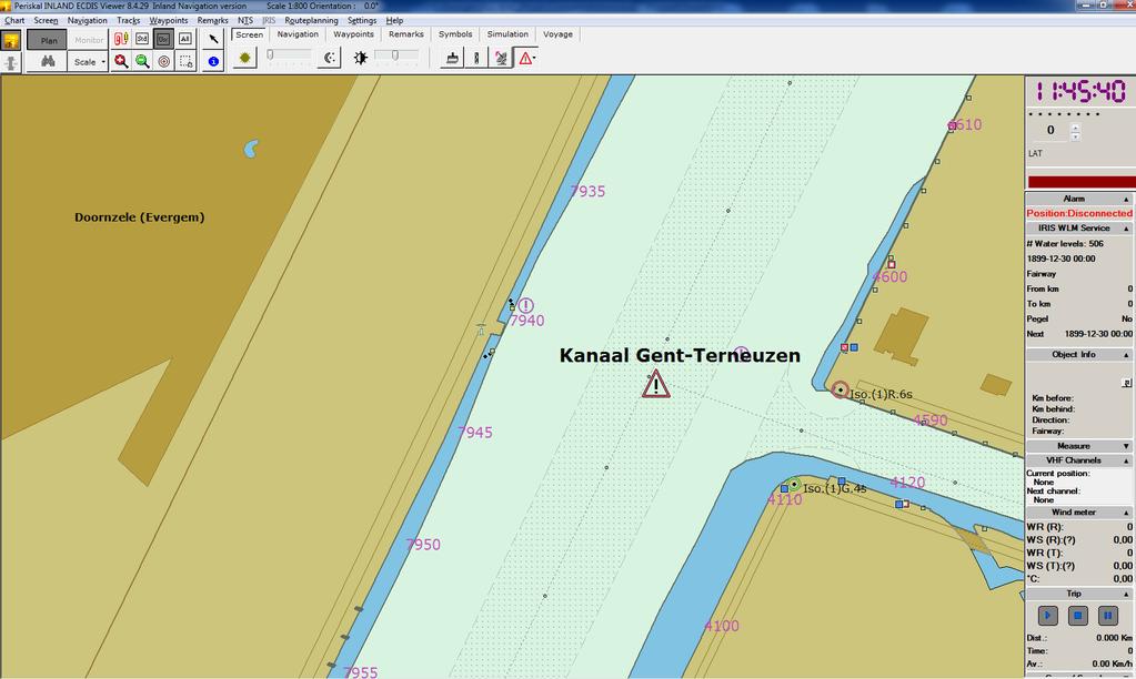
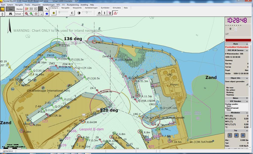
7 Working Area Flemish Hydrography 1/2 Total area to be mapped by FH is approximately 640 km²
8 Product Specifications 1/2 Specification Chart name USAGE -> Scale Bathymetry Canal Ghent-Terneuzen adjacing the seaport Antwerp N: western Scheldt from dutch-belgian Antwerp S: Antwerp Rede up till lock of Wintam Ghent border up Antwerp Rede BE7GT017 BE7BZ001 BE7BZ / / / Dredged area as DRGARE (± target depth) + caution area for w arning areas outside of dredged area= real bathymetry: 0,2,5,8,10-meter contours outsidedrgarebased upon minimum depth. Fairw ay KGT = DRGARE. Embankments = real bathymetry Dredged area as DRGARE (± target depth) + caution area for w arning areas outside of dredged area= real bathymetry: 0,2,5,8,10-meter contours outsidedrgarebased upon minimum depth. Fairw ay Schelde = DRGARE. Embankments = real bathymetry Dredged area as DRGARE (± target depth) + caution area for w arning areas outside of dredged area= real bathymetry: 0,2,5,8,10-meter contours outsidedrgarebased upon minimum depth. Fairw ay Schelde = DRGARE. Embankments = real bathymetry RIS index Detailing chart Waterway axes applied for : quay numbers bridges locks distance marks bollards obstacles moorings buildings names company traffic signs lights buoys radars camera pier, jetty pontoon motorw ays, roads railw ays residential areas applied for : quay numbers bridges locks distance marks terminals bollards obstacles moorings buildings names company traffic signs lights buoys radars camera pier, jetty pontoon motorw ays, roads railw ays residential areas yes yes yes applied for : quay numbers bridges locks distance marks terminals bollards obstacles moorings buildings names company traffic signs lights buoys radars camera pier, jetty pontoon motorw ays, roads railw ays residential areas
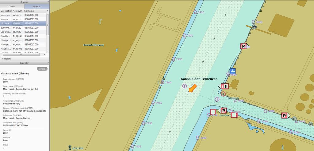
9 RIS index Location code (ISRS code): unique ID for each piece of infrastructure 20 digit alphanumerical code (UNLOCODE): BEBGS07401L The RIS Index describes several RIS objects on waterways (such as junctions, locks, bridges, berths, gauges etc). Countries applying RIS are obliged to identify the objects RIS Index Encoding Guide version v0.8 (December 2010) need to develop a European wide encoded harmonized list of objects

10 Integration of RIS


11 Workflow Production IENC: detail Data Storage Process (End) Product


12 IENC: Data management in CARIS HPD Source Editor


13 IENC: IENC creation in CARIS HPD Product Editor


14 IENC: Extra Quality Checks
15 Distribution of the IENC Flemish RIS Portal:
16 Thank you for your attention! The end..
INVENTORY FOR HARMONISED INLAND AIS APPLICATION SPECIFIC MESSAGES IN EUROPE
 INVENTORY FOR HARMONISED INLAND AIS APPLICATION SPECIFIC MESSAGES IN EUROPE GUIDELINES OF THE VTT EXPERT GROUP Edition 1.2 Version: 12-07-2017 Author: Vessel Tracking and Tracing Expert Group TABLE OF
GUIDANCE FOR THE PRESENTATION AND DISPLAY OF AIS APPLICATION-SPECIFIC MESSAGES INFORMATION
 E 4 ALBERT EMBANKMENT LONDON SE1 7SR Telephone: +44 (0)20 7735 7611 Fax: +44 (0)20 7587 3210 Ref. T2-OSS/2.7.1 SN.1/Circ.290 2 June 2010 GUIDANCE FOR THE PRESENTATION AND DISPLAY OF AIS APPLICATION-SPECIFIC
RIS in Germany. RIS week Berlin.
 RIS in Germany RIS week 2014 Berlin www.bmvi.de Main Waterways in Germany The German Waterway and Shipping Administration maintains 23,000 km² maritime waterways 7,300 km inland waterways 5,100 km main
DISC Ukrainian National Status Report
 DISC 2016 Ukrainian National Status Report NU OMA, prof.doct.tech Igor Gladkykh phone +380503909586 e-mail:gladkykh958@gmail.com Nick Golodov Hydrography Service of Ukraine phone +380444256874 e-mail:
RIVER INFORMATION SERVICES ON THE ODRA RIVER
 RIVER INFORMATION SERVICES ON THE ODRA RIVER PIOTR DURAJCZYK INLAND NAVIGATION OFFICE IN SZCZECIN NETWORK OF EUROPEAN WATERWAYS Źródło: K. Woś na podstawie European Agreement on Main Inland Waterways of
Helping Build Your Capacity in Nautical Charting & Hydrography
 Helping Build Your Capacity in Nautical Charting & Hydrography Helping Chart your World Rajesh Alla Riyadh, Kingdom of Saudi Arabia 04-06 March 2013 Company Background Marine Services Capacity Building
Ship Manoeuvring in Shallow and Confined Water. Prof. Dr. Katrien Eloot Antwerp
 Ship Manoeuvring in Shallow and Confined Water Prof. Dr. Katrien Eloot 25-03-2010 Antwerp Summary Knowledge Centre Manoeuvring in Shallow and Confined Water History Purpose and objectives Recent and future
Paper for Consideration by S-100WG3. Report on S-100 Sea trial of KHOA
 S-100WG3-8.1 Paper for Consideration by S-100WG3 Report on S-100 Sea trial of KHOA Submitted by: Executive Summary: Related Documents: Related Projects: Republic of Korea (KHOA) This paper reports the
e-navigation Progress and trends: the IHO perspective
 International Hydrographic Organization e-navigation Progress and trends: the IHO perspective Gilles Bessero Director, IHO International Hydrographic Organization Intergovernmental consultative and technical
Evaluation IENC Usages RWS
 Ordered by Rijkswaterstaat DVS Author: P.A. Kluytenaar Rotterdam, 29 juli 2010 Serendipity UnLtd, Veerkade 15, Rotterdam Content Chapter page Summary 1. Introduction... 2 2. Approach... 3 3. Scale/ range
NOAA s National Ocean Service / Office of Coast Survey
 Coast Survey OCS 1807 2007 Maintains over 1000 nautical charts & 9 Coast Pilots Surveys over 3.4M SNM of oceans and lakes Conducts research and development in hydrography Thomas Jefferson Founder of The
INFORMATION PAPER ON AIS AIDS TO NAVIGATION REPORT MESSAGES IN INLAND WATERWAYS
 INFORMATION PAPER ON AIS AIDS TO NAVIGATION REPORT MESSAGES IN INLAND WATERWAYS Edition 1.1 Version: 09-05-2017 Author: Inland ECDIS Expert Group and Vessel Tracking and Tracing Expert Group VTT / IECDIS
Joint Announcement. no Official languages in area managed by the Common Nautical Authority
 Joint Announcement no. 04 2011 Official languages in area managed by the Common Nautical Authority The Dutch Governmental Harbour Master for the Western Scheldt and the Flemish Administrator General of
FOREWORD. IHO S-100 Working Group
 IHO International Hydrographic Organization KHOA Korea Hydrographic and Oceanographic Agency MUCH MORE THAN JUST NAUTICAL CHARTS IHO UNIVERSAL HYDROGRAPHIC data MODEL This document was produced with the
DEVELOPMENT OF A DEFINITION FOR MSPS AND CONSIDERATION FOR THE HARMONIZATION OF THE FORMAT AND STRUCTURE OF MSPS
 INTERNATIONAL HYDROGRAPHIC ORGANIZATION E IMO/IHO HARMONIZATION GROUP ON DATA MODELLING Agenda item 5 15 September 2017 ENGLISH ONLY DEVELOPMENT OF A DEFINITION FOR MSPS AND CONSIDERATION FOR THE HARMONIZATION
ECDIS ENC Accuracy. Contents. Introduction LOSS PREVENTION BRIEFING FOR NORTH MEMBER SHIPS / MAY Introduction... 1
 LOSS PREVENTION BRIEFING FOR NORTH MEMBER SHIPS / MAY 2017 ECDIS ENC Accuracy Contents Introduction... 1 ECDIS Specific Familiarisation... 2 IHO S-57... 2 ENC Data Source... 2 CATZOC and M_QUAL... 2 CATZOC
BookletChart. Sacramento River Andrus Island to Sacramento NOAA Chart A reduced-scale NOAA nautical chart for small boaters
 BookletChart Sacramento River Andrus Island to Sacramento NOAA Chart 18662 A reduced-scale NOAA nautical chart for small boaters When possible, use the full-size NOAA chart for navigation. Included Area
The Future for the AIS AtoN. Michael Card Zeni Lite Buoy Co., Ltd., Japan
 The Future for the AIS AtoN Michael Card Zeni Lite Buoy Co., Ltd., Japan History Early work in USA and Europe Not compatible with UAIS First UAIS AIS AtoN was Akari-400 Launched at IALA Sydney, 8 years
Notices to Mariners OSTEND NOVEMBER 11TH 2010 NR.23
 Notices to Mariners + OSTEND NOVEMBER 11TH 2010 NR.23 1 BELGIUM >23/284 BELGIAN COAST - UNDERSEA CABLE UNUSED - CHART CORRECTION The undersea cable with symbol INT1 L 30.1 and coordinates: 51 06,925 N
National Report of Finland
 National Report of Finland 1. Finnish Hydrographic Office The Finnish Hydrographic Office is organized under The Finnish Transport Agency. The Finnish Transport Agency is responsible for the Finnish roads,
Western Region enavigation Sub- Committee Report
 Western Region enavigation Sub- Committee Report Western Region enavigation meeting - Jan 12 18 BC Ferries BC Coast Pilots BCIT Marine Campus Canadian Coast Guard Canadian Hydrographic Services Canadian
Paper for Consideration by DIPWG
 TSMAD20/DIPWG2-15A Paper for Consideration by DIPWG Considerations for Symbolizing Nautical Publication Information in ECDIS Submitted by: Executive Summary: Related Documents: Related Projects: DIPWG
World-Wide Navigational Warning Service Sub-Committee WWNWS-5 Monaco, 1-4 October S-100 Basics Background Brief
 International Hydrographic Organization World-Wide Navigational Warning Service Sub-Committee WWNWS-5 Monaco, 1-4 October 2013 S-100 Basics Background Brief Gilles Bessero 15:29 1 S-100 Basics S-100 -
PRODUCTS AND SERVICES FOR THE MARITIME COMMUNITY. Ed Martin, Chief Customer Affairs Branch Navigation Services Division Monday, 27 October, 2008
 PRODUCTS AND SERVICES FOR THE MARITIME COMMUNITY Ed Martin, Chief Customer Affairs Branch Navigation Services Division Monday, 27 October, 2008 Coral Reef Conservation International Collaboration Marine
Catalogue of Hydrographic Publications.
 Catalogue of Hydrographic Publications 2017 www.vlaamsehydrografie.be 1 index 1. CHARTS 03 1.1. Chart 1 - INT 1 03 1.2. Paper Charts 03 1.2.1. Charts 03 1.2.2. Chart sets 04 1.2.3. Overview charts 04 1.3.
COMMISSION IMPLEMENTING REGULATION (EU)
") 28.7.2012 Official Journal of the European Union L 202/5 REGULATIONS COMMISSION IMPLEMENTING REGULATION (EU) No 689/2012 of 27 July 2012 amending Regulation (EC) No 415/2007 concerning the technical specifications
28.7.2012 Official Journal of the European Union L 202/5 REGULATIONS COMMISSION IMPLEMENTING REGULATION (EU) No 689/2012 of 27 July 2012 amending Regulation (EC) No 415/2007 concerning the technical specifications
THE ELECTRONIC CHART DISPLAY AND INFORMATION SYSTEM (ECDIS) IN CHINA
 IN CHINA") International Hydrographic 'Review, Monaco, LXIX(2), September 1992 THE ELECTRONIC CHART DISPLAY AND INFORMATION SYSTEM (ECDIS) IN CHINA by The Research Group on ECDIS 1 Abstract This paper presents a
International Hydrographic 'Review, Monaco, LXIX(2), September 1992 THE ELECTRONIC CHART DISPLAY AND INFORMATION SYSTEM (ECDIS) IN CHINA by The Research Group on ECDIS 1 Abstract This paper presents a
Electronic Chart Display and Information System for Inland Navigation (Inland ECDIS)
") Central Commission for the Navigation of the Rhine (CCNR) Enclosure to protocol 2006-II-22 Electronic Chart Display and Information System for Inland Navigation (Inland ECDIS) Edition 2.3 Central Commission
Central Commission for the Navigation of the Rhine (CCNR) Enclosure to protocol 2006-II-22 Electronic Chart Display and Information System for Inland Navigation (Inland ECDIS) Edition 2.3 Central Commission
NEW AND AMENDED TRAFFIC SEPARATION SCHEMES
 E 4 ALBERT EMBANKMENT LONDON SE1 7SR Telephone: +44 (0)20 7735 7611 Fax: +44 (0)20 7587 3210 NEW AND AMENDED TRAFFIC SEPARATION SCHEMES COLREG.2/Circ.67 20 May 2016 1 The Maritime Safety Committee, at
IALA Guideline No. XXXX. The establishment of AIS as an Aid to Navigation. Edition 1.3. [Date] Working vs / Working 7.
![IALA Guideline No. XXXX. The establishment of AIS as an Aid to Navigation. Edition 1.3. [Date] Working vs / Working 7.](/thumbs/74/71399138.jpg "IALA Guideline No. XXXX. The establishment of AIS as an Aid to Navigation. Edition 1.3. [Date] Working vs / Working 7.") ANM12/Output/10 International Association of Marine Aids to Navigation and Lighthouse Authorities AISM Association of Internationale de Signalisation Maritime IALA IALA Guideline No. XXXX On The establishment
ANM12/Output/10 International Association of Marine Aids to Navigation and Lighthouse Authorities AISM Association of Internationale de Signalisation Maritime IALA IALA Guideline No. XXXX On The establishment
Using a Pilot Laptop with the AIS pilot plug - observed errors and difficulties
 Using a Pilot Laptop with the AIS pilot plug - observed errors and difficulties 2 nd November 2008 The following pages and images detail the errors found and experience in using his Pilot Laptop by a Australian
Appendix: References and glossary
 Appendix: References and glossary Facts about electronic charts and carriage requirements 2nd edition 2007 V/1 CONTENTS OF SECTION 5 Appendix: References and glossary References...................................................
PART II CANAL AND LAKES (CHARACTERISTICS) CHAPTER VI CANAL AND LAKES CHARACTERISTICS
 CHAPTER VI CANAL AND LAKES CHARACTERISTICS") PART II CANAL AND LAKES (CHARACTERISTICS) CHAPTER VI CANAL AND LAKES CHARACTERISTICS Art. 79- Canal and Approaches: A- THE NAVIGABLE CHANNEL: (1) North Approach Channel (Port Said) : (1.1) East: a) From
PART II CANAL AND LAKES (CHARACTERISTICS) CHAPTER VI CANAL AND LAKES CHARACTERISTICS Art. 79- Canal and Approaches: A- THE NAVIGABLE CHANNEL: (1) North Approach Channel (Port Said) : (1.1) East: a) From
BookletChart. Chesapeake Bay Pocomoke and Tangier Sounds NOAA Chart A reduced-scale NOAA nautical chart for small boaters
 BookletChart Chesapeake Bay Pocomoke and Tangier Sounds NOAA Chart 12228 A reduced-scale NOAA nautical chart for small boaters When possible, use the full-size NOAA chart for navigation. Published by the
ETSI Workshop "Future Evolution of Marine Communication Radar evolution for inland waterways navigation Mario Walterfang
 Mario Walterfang Fachstelle der WSV für Verkehrstechniken (FVT) Federal German Waterways and Shipping Administration Sophia Antipolis, France, November 7th, 2017 Overview Milestones in river radar evolution
United States Coast Guard Office of Navigation Systems
 United States Coast Guard Office of Navigation Systems Future of Navigation Initiatives & Operations R. David Lewald Program Analyst Navigation Systems Office of Navigation Systems U.S. Coast Guard Washington,
Catalogue of Hydrographic Publications.
 Catalogue of Hydrographic Publications 2018 www.vlaamsehydrografie.be 1 index 1. CHARTS 03 1.1. Chart 1 - INT 1 03 1.2. Paper Charts 03 1.2.1. Charts 03 1.2.2. Chart sets 04 1.2.3. Overview charts 04 1.3.
BookletChart. Approaches to Cap-Haitien and Bahia de Monti Cristi NGA Chart A reduced-scale NGA nautical chart for small boaters
 BookletChart Approaches to Cap-Haitien and Bahia de Monti Cristi NGA Chart 26142 A reduced-scale NGA nautical chart for small boaters When possible, use the full-size NGA chart or Electronic Nautical Chart
17 th CHRIS Meeting Rostock, Germany, 5-9 September Report of IHO-IEC Harmonization Group on Marine Information Objects (HGMIO
 17 th CHRIS Meeting Rostock, Germany, 5-9 September 2004 CHRIS17-7A rev.1 Report of IHO-IEC Harmonization Group on Marine Information Objects (HGMIO Lee Alexander, University of New Hampshire (Chair, HGMIO)
ANNEX ANNEX. Accompanying the document. Commission Implementing Regulation
 Ref. Ares(2018)3546601-04/07/2018 EUROPEAN COMMISSION Brussels, XXX [ ](2018) XXX draft ANNEX ANNEX Accompanying the document Commission Implementing Regulation on technical specifications for vessel tracking
3D Port Creation & Simulator Builds
 3D Port Creation & Simulator Builds The technology has moved on so much, it s incredible that we can now create large and extremely accurate bespoke ports for shipping companies, and, more importantly
REGIONAL HYDROGRAPHIC COMMISSIONS CAPACITY BUILDING NSHC NHC BSHC USCHC USCHC EAtHC MBSHC RSAHC EAHC MACHC NIOHC SWPHC SEPHC (SWAtHC) SAIHC SWPHC HCA
 SAIHC SWPHC HCA") CONTENT THE VALUE of HYDROGRAPHIC INFORMATION and its INFLUENCE By THE INTERNATIONAL HYDROGRAPHIC ORGANIZATION I.II.III.IV.V.- INTRODUCTION HYDROGRAPHIC INFORMATION OF MAIN VALUE ACTIVITIES THAT BENEFIT
CONTENT THE VALUE of HYDROGRAPHIC INFORMATION and its INFLUENCE By THE INTERNATIONAL HYDROGRAPHIC ORGANIZATION I.II.III.IV.V.- INTRODUCTION HYDROGRAPHIC INFORMATION OF MAIN VALUE ACTIVITIES THAT BENEFIT
A LASER RANGE-FINDER SCANNER SYSTEM FOR PRECISE MANEOUVER AND OBSTACLE AVOIDANCE IN MARITIME AND INLAND NAVIGATION
 A LASER RANGE-FINDER SCANNER SYSTEM FOR PRECISE MANEOUVER AND OBSTACLE AVOIDANCE IN MARITIME AND INLAND NAVIGATION A.R. Jiménez, R.Ceres and F. Seco Instituto de Automática Industrial - CSIC Ctra. Campo
JOURNAL OF MARITIME RESEARCH. The Architecture of Data Transmission in Inland Navigation
 JOURNAL OF MARITIME RESEARCH Vol XI. No. II (2014) pp 3 7 ISSN: 1697-4040, www.jmr.unican.es The Architecture of Data Transmission in Inland Navigation A. Lisaj 1,2, and P. Majzner 3 ARTICLE INFO Article
How Automatic Identification System (AIS) Is Being Used to Improve Navigation Safety Lock Operations Management Application Michael Winkler
 Is Being Used to Improve Navigation Safety Lock Operations Management Application Michael Winkler") How Automatic Identification System (AIS) Is Being Used to Improve Navigation Safety Lock Operations Management Application Michael Winkler June 2016 LOMA system overview USCG AIS data capabilities: AIS
How Automatic Identification System (AIS) Is Being Used to Improve Navigation Safety Lock Operations Management Application Michael Winkler June 2016 LOMA system overview USCG AIS data capabilities: AIS
INTERNATIONAL STANDARD
 INTERNATIONAL STANDARD IEC 61174 Edition 4.0 2015-08 colour inside Maritime navigation and radiocommunication equipment and systems Electronic chart display and information system (ECDIS) Operational and
Notices to Mariners. OSTEND MARCH 13th 2014 NR. 06
 Notices to Mariners + OSTEND MARCH 13th 2014 NR. 06 1 BELGIUM >06/099 (T) NIEUWPOORT - SEAWARD GUNNERY EXERCISES BaZ 2014-05/086 (T) is cancelled. During the period from 31/03/2014 until and including
Government Agency Perspectives & Initiatives Canadian Coast Guard Laurent Tardif, Director, Safe Shipping
 Unclassified Government Agency Perspectives & Initiatives Canadian Coast Guard Laurent Tardif, Director, Safe Shipping Mariner s Workshop January 23, 2019 1 Overview 1 Context 2 Marine Fees 3 4 5 Update
dkart Navigator 9010
 dkart Navigator 9010 dkart Navigator - purpose dkart Navigator is an electronic navigation chart system specially designed to facilitate all the navigational tasks of mariner's day-to-day practice. Along
Procedure VHF Communication VTS and HCC Port of Rotterdam Authority Harbour Master's Division
 Procedure VHF Communication VTS and HCC Port of Rotterdam Authority Harbour Master's Division Author: B. Röhner Date: Contents 1. PROCEDURE VHF COMMUNICATION VESSEL TRAFFIC SERVICES (VTS)... 1 2. Area
BookletChart. Sacramento River Sacramento to Fourmile Bend NOAA Chart A reduced-scale NOAA nautical chart for small boaters
 BookletChart Sacramento River Sacramento to Fourmile Bend NOAA Chart 18664 A reduced-scale NOAA nautical chart for small boaters When possible, use the full-size NOAA chart for navigation. Included Area
GNSS in Maritime and Education in Egypt
 GNSS in Maritime and Education in Egypt GNSS IN MARITIME PORTS SHIPS PORTS WATERWAYS GNSS maritime applications will help to improve: navigation. Ship operations. Traffic management. Seaport operations.
Recent Developments in NOAA s Real- Time Coastal Observing Systems for Safe and Efficient Maritime Transportation
 Recent Developments in NOAA s Real- Time Coastal Observing Systems for Safe and Efficient Maritime Transportation Rich Edwing, Director NOAA Center for Operational Oceanographic Products and Services CMTS
SPECIFICATION FOR TOPOGRAPHIC AND HYDROGRAPHIC SURVEYS OF RECLAMATION AND DREDGING WORKS
 23 August 2001 SPECIFICATION FOR TOPOGRAPHIC AND HYDROGRAPHIC SURVEYS OF RECLAMATION AND DREDGING WORKS 1.0 EXTENT OF WORKS The main survey works shall comprise of the following : a. Carry out topographic
High precision hydrography The St. Lawrence River channel HD Bathymetry, Production, Distribution and Updating
 HYDRO12 Conference High precision hydrography The St. Lawrence River channel HD Bathymetry, Production, Distribution and Updating M. Journault, L. Maltais, and R. Sanfaçon Canadian Hydrographic Service
We wish you a Happy New Year!
 NEWSLETTER No. 3 I January 2014 Programme co-funded by the European Union NEWADA duo Network of Danube Waterway Administrations - data and user orientation is an EU project, funded under the South East
GUIDELINES ON THE DESIGN AND USE OF PORTABLE PILOT UNITS INTERNATIONAL MARITIME PILOTS ASSOCIATION
 GUIDELINES ON THE DESIGN AND USE OF PORTABLE PILOT UNITS INTERNATIONAL MARITIME PILOTS ASSOCIATION WITH TECHNICAL INPUT FROM Comité International Radio-Maritime (CIRM) 2 FOREWORD With the increasing use
GeoCoastPilot: Linking the Coast Pilot with Georeferenced Imagery & Chart Information
 University of New Hampshire University of New Hampshire Scholars' Repository Center for Coastal and Ocean Mapping Center for Coastal and Ocean Mapping 10-2008 GeoCoastPilot: Linking the Coast Pilot with
Myanmar Naval Hydrographic Centre. National Report for 13 th North Indian Ocean Hydrographic Commission Meeting
 Myanmar Naval Hydrographic Centre National Report for 13 th North Indian Ocean Hydrographic Commission Meeting Yangon, Myanmar 19 th 22 nd February 2013 CONTENT 1. Myanmar Naval Hydrographic Centre 2.
A Survey of Mariners' Opinions on Using Electronic Charts
 s i l s Note A Survey of Mariners' Opinions on Using Electronic Charts Igor Karnicnik, M.Sc., Geodetic Institute of Slovenia, Slovenia. A new component of modern shipborne navigation equipment is the Electronic
Innovating through Technology at the Seaway Even Old Infrastructure Dogs Can Learn New Tricks
 Innovating through Technology at the Seaway Even Old Infrastructure Dogs Can Learn New Tricks Straight from the Source Series Cambridge, Mass. July 26, 2012 Craig H. Middlebrook, Acting Administrator Saint
VHF (working) procedures
 procedures") VHF (working) procedures River Scheldt VTS Area Version 5.2 Dated: December 2017 1 PREAMBEL These VHF procedures are for the guidance of traffic participants, for VTS operators and for pilots participating
VHF (working) procedures River Scheldt VTS Area Version 5.2 Dated: December 2017 1 PREAMBEL These VHF procedures are for the guidance of traffic participants, for VTS operators and for pilots participating
Six in One or One in Six Variants. Electronic Navigational Charts for Open Sea, Coastal, Off- Shore, Harbour, Sea-River and Inland Navigation
 International Journal on Marine Navigation and Safety of Sea Transportation Volume 4 Number 2 June 2010 Six in One or One in Six Variants. Electronic Navigational Charts for Open Sea, Coastal, Off- Shore,
A guideline for establishing feature and symbol standard management system for national HOs
 A guideline for establishing feature and symbol standard management system for national HOs Joint 26th TSMAD and 5th DIPWG Meeting Silver Spring, Maryland, USA(10-14 June 2013) Republic of Korea (ROK)
Nordic Hydrographic Commission 60th Conference - Stavanger - Norway April New national ENC service for leisure craft users
 Nordic Hydrographic Commission 60th Conference - Stavanger - Norway 11-13 April 2016 New national ENC service for leisure craft users New national ENC service for leisure craft users The aim of the new
IALA S WORK IN E-NAVIGATION. Michael Card
 IALA S WORK IN E-NAVIGATION Michael Card e-navigation origins The early work of IALA on e-navigation Multiple Initiatives EfficienSea 2 STM Validation IHO S-100 and IALA S-200 Smart Navigation VDES development
Tide & Meteorological Data over AIS
 Tide & Meteorological Data over AIS E.F.Read (Ohmex Ltd) & W.S.Heaps (ABP Ltd) THSUK Hydro8 1 Background to AIS Most significant development since RADAR Positions and Timing from GPS network 12.5 Watt
BookletChart. Intracoastal Waterway Grassy Key to Bahia Honda Key NOAA Chart A reduced-scale NOAA nautical chart for small boaters
 BookletChart Intracoastal Waterway Grassy Key to Bahia Honda Key NOAA Chart 11453 A reduced-scale NOAA nautical chart for small boaters When possible, use the full-size NOAA chart for navigation. Published
Profile description of the Chair of Ports and Waterways
 Faculty Civil Engineering and Geosciences Department of Hydraulic Engineering Profile description of the Chair of Ports and Waterways 1. Position of the Chair of Ports and Waterways 1.1 Background With
MBSHC (Mediterranean and Black Seas Hydrographic Commission) XVII. conference, Greece Jun. 2011
 XVII. conference, Greece Jun. 2011") MBSHC (Mediterranean and Black Seas Hydrographic Commission) XVII. conference, Greece 01. 03. Jun. 2011 National report of SLOVENIA 01. May 2011 MBSHC report - SLOVENIA 1 0 Index 0 Index... 2 1 Hydrographic
MBSHC (Mediterranean and Black Seas Hydrographic Commission) XVII. conference, Greece 01. 03. Jun. 2011 National report of SLOVENIA 01. May 2011 MBSHC report - SLOVENIA 1 0 Index 0 Index... 2 1 Hydrographic
MARINE ELECTRONIC HIGHWAY IN STRAITS OF MALACCA AND SINGAPORE. Development of Supporting Element for Future & Sustainable Operation
 COOPERATION FORUM UNDER THE COOPERATIVE MECHANISM ON SAFETY OF NAVIGATION AND ENVIRONMENTAL PROTECTION IN THE STRAITS OF MALACCA AND SINGAPORE 7th SESSION Agenda Item... CF 7/... 22-23 September 2014 Original.
United States - Canada Hydrographic Commission Halifax, Canada May 16, 2016
 United States - Canada Hydrographic Commission Halifax, Canada May 16, 2016 USCHC39 INF-E NOAA Pilot Study Applying Satellite-Derived Bathymetry to Longboat Pass, Florida Submitted by: The United States
NHC 59th meeting Agenda item NHC59-9A April 14-15, 2015 Reykjavik - Iceland. New national ENC service for leisure craft users
 NHC 59th meeting Agenda item NHC59-9A April 14-15, 2015 Reykjavik - Iceland New national ENC service for leisure craft users The aim of the new ENC service The aim of the new ENC service is to enhance
GLMTF November 18, 2014 Presentation
 GLMTF November 18, 2014 Presentation Michigan Security Network Founded by major corporations, industry leaders and leading universities in 2008 as a non-profit organization (501c6). MiSN mission is to
ROUTEING OF SHIPS, SHIP REPORTING AND RELATED MATTERS. New traffic separation schemes and two-way routes in Norra Kvarken
 E SUB-COMMITTEE ON SAFETY OF NAVIGATION 57th session Agenda item 3 NAV 57/3/7 11 March 2011 Original: ENGLISH ROUTEING OF SHIPS, SHIP REPORTING AND RELATED MATTERS New traffic separation schemes and two-way
The Present Status of Small Scale ENC Coverage with Respect to the Allocation of cells to Usage Bands 1 (Overview) and 2 (General).
 and 2 (General).") CHRIS19-06.1E 19 th CHRIS MEETING Rotterdam, Netherlands, 5-9 November 2007 The Present Status of Small Scale ENC Coverage with Respect to the Allocation of cells to Usage Bands 1 (Overview) and 2 (General).
CHRIS19-06.1E 19 th CHRIS MEETING Rotterdam, Netherlands, 5-9 November 2007 The Present Status of Small Scale ENC Coverage with Respect to the Allocation of cells to Usage Bands 1 (Overview) and 2 (General).
THE IHO, ELECTRONIC CHARTING AND THE CHANGING RELATIONSHIP TO PORTS
 International Hydrographic Review, Monaco, LXXI(2), September 1994 THE IHO, ELECTRONIC CHARTING AND THE CHANGING RELATIONSHIP TO PORTS by Rear Admiral Christian ANDREASEN1 (Presented at European Harbour
EGYPTIAN HYDROGRAPHIC DEPARTMENT THE EGYPTIAN HYDROGRAPHIC FRAMEWORK
 gvt THE EGYPTIAN HYDROGRAPHIC FRAMEWORK The roles of a national Hydrographic Service can be summarized in collecting georeferenced data through systematic surveys at sea and along the coast related to:
The ship RV Timba repairs are now almost complete and it is expected that come September 2014 the ship will be fully operational.
 Malawi National Report 2014 1 Malawi Hydrographic Office The assembly of the 70 ton ship RV Timba with the assistance of the French government in 1989 ushered in the commencement of modern hydrographic
The ship safety zones in vessel traffic monitoring and management systems
 Scientific Journals of the Maritime University of Szczecin Zeszyty Naukowe Akademii Morskiej w Szczecinie 2016, 48 (120), 153 158 ISSN 1733-8670 (Printed) Received: 29.04.2016 ISSN 2392-0378 (Online) Accepted:
Paper 34 - Workshop on Design Guidelines for Inland Waterways Introduction to WG 141 Approach and Findings
 Paper 34 - Workshop on Design Guidelines for Inland Waterways Introduction to WG 141 Approach and Findings SÖHNGEN B. Bundesanstalt für Wasserbau (BAW; Federal Waterways Research Institute), Karlsruhe,
(P.27)
") (P.27) 27 7 210 120 8 * Navigation and Anchoring Prohibited Area has been changed since June, 2017. 9 Port of Osaka The Guidelines of Measures for preventing Typhoon Disaster ( Objective )
(P.27) 27 7 210 120 8 * Navigation and Anchoring Prohibited Area has been changed since June, 2017. 9 Port of Osaka The Guidelines of Measures for preventing Typhoon Disaster ( Objective )
MESOAMERICAN AND CARIBBEAN HYDROGRAPHIC COMMISSION 11 th Meeting, Paramaribo, Suriname, Novembro NATIONAL REPORT BRAZIL
 Page 1 of 5 MESOAMERICAN AND CARIBBEAN HYDROGRAPHIC COMMISSION 11 th Meeting, Paramaribo, Suriname, Novembro 8-12 2010 NATIONAL REPORT BRAZIL 1. Hydrographic Office / Service: Directorate of Hydrography
E-NAVIGATION AND BEYOND
 E-NAVIGATION AND BEYOND The Work of IALA e-navigation Committee and Future CDR. Hideki NOGUCHI, Chair, IALA ENAV Committee e-navigation (ENAV) Committee Established in 2010 by merging R-NAV and AIS Committee
STANDING NOTICE TO MARINERS
 ASSOCIATED BRITISH PORTS P O BOX 1, PORT HOUSE, NORTHERN GATEWAY, HULL HU9 5PQ STANDING NOTICE TO MARINERS (No. S.H. 2) ASSOCIATED BRITISH PORTS VESSEL TRAFFIC SERVICES HUMBER HARBOUR AREA Associated British
«INTRARADAR» Port of Corfu
 «INTRARADAR» Port of Corfu INTERREG IIIA Greece-Italy IMPETUS was the contractor of the Prefecture of Corfu for the INTRARADAR project. The project focused on the provision, installation of hardware/software
IHO Colours & Symbols Maintenance Working Group (C&SMWG) 15th Meeting, BSH, Rostock, Germany, 2-4 May 2005
 15th Meeting, BSH, Rostock, Germany, 2-4 May 2005") CSMWG15-INF2 IHO Colours & Symbols Maintenance Working Group (C&SMWG) 15th Meeting, BSH, Rostock, Germany, 2-4 May 2005 Ref: HA405/004/033-01 NOTE: this is an internal document of the UKHO and is supplied
CSMWG15-INF2 IHO Colours & Symbols Maintenance Working Group (C&SMWG) 15th Meeting, BSH, Rostock, Germany, 2-4 May 2005 Ref: HA405/004/033-01 NOTE: this is an internal document of the UKHO and is supplied
Challenges and opportunities in the e-navigation Development. Actual projects.
 Challenges and opportunities in the e-navigation Development. Actual projects. John Erik Hagen, Regional Director Oslo, September 2018 What is e-navigation? Efficient transfer of marine information and
HYDROGRAPHIC SURVEY STANDARDS AND DELIVERABLES
 TABLE OF CONTENTS 1. HYDROGRAPHIC SURVEY METHODOLOGY... 3 2. HYDROGRAPHIC SURVEY REFERENCE STANDARDS... 3 3. HYDROGRAPHIC SURVEY CRITERIA... 3 3.1 HYDROGRAPHIC SURVEYS OVER NON GAZETTED NAVIGABLE WATERS*:...
Display of e-navigation information
 Display of e-navigation information Where do we display all this new information? Thomas Porathe Professor, Interaction design Department of Product design Norwegian University of Science and Technology
AHO Chart Line Feature. Specification
 Document No SPEC_01_05_A149493 Version 1 PRINTED COPIES ARE UNCONTROLLED DRS ID A149493 HYDROGRAPHIC, ETEOROLOGICAL & OCEANOGRAPHIC FORCE ELEENT GROUP ANAGEENT SYSTE DOCUENT AHO Chart Line Feature Specification.
National Maritime Center
 National Maritime Center Providing Credentials to Mariners (Sample Examination) Page 1 of 6 Choose the best answer to the following Multiple Choice Questions. 1. The following questions are based on Chart
Sensor Data Fusion in Inland Navigation
 Sensor Data Fusion in Inland Navigation Andrzej Stateczny, Witold Kazimierski Faculty of Navigation, Chair of Geoinformatics Maritime University of Szczecin 70-500 Szczecin, Waly Chrobrego 1-2, Poland
Economic and Social Council
 UNITED NATIONS E Economic and Social Council Distr. GENERAL ECE/TRANS/SC.3/WP.3/2008/10 21 December 2007 Original: ENGLISH ECONOMIC COMMISSION FOR EUROPE INLAND TRANSPORT COMMITTEE Working Party on Inland
Inland Waterways Users Board #60. Inland Navigation R&D
 Inland Waterways Users Board #60 Inland Navigation R&D 19 February 2009 Vicksburg, MS Agenda 0845-0900 Welcome Dr. Jeff Holland 0900 0920 Agenda & Navigation R&D Overview Mr. Jeff Lillycrop 0920-0940 Mississippi
11 th CHRIS MEETING IHB, Monaco, November Draft - - -
 CHRIS/11/16A 11 th CHRIS MEETING IHB, Monaco, 16-18 November 1999 - - - Draft - - - Workshop on Development of Marine Information Objects (MIO) for ECDIS Burlington, Ontario, Canada 8-9 November 1999 Record
No MARCH 2014 UNITED STATES OF AMERICA. Contents
 10 8 MARCH 2014 UNITED STATES OF AMERICA Published Weekly by the National Geospatial-Intelligence Agency Prepared Jointly with the National Ocean Service and U.S. Coast Guard Contents Section I Chart Corrections............................................
Maritime Safety and Security Information Exchange System new possibilities based on modern IT technologies
 Maritime Safety and Security Information Exchange System new possibilities based on modern IT technologies HELCOM AIS EWG 21/2010, 27-28 October 2010 Artur Baranowski artur.baranowski@sprint.pl Michał
The Role of Automatic Identification System (AIS) in Enhancing Vessel Traffic Management By Capt. Ehab Ibrahim Etman
 in Enhancing Vessel Traffic Management By Capt. Ehab Ibrahim Etman") The Role of Automatic Identification System (AIS) in Enhancing Vessel Traffic Management By Capt. Ehab Ibrahim Etman Abstract The International Maritime Organization (IMO) adopted a new requirement for
The Role of Automatic Identification System (AIS) in Enhancing Vessel Traffic Management By Capt. Ehab Ibrahim Etman Abstract The International Maritime Organization (IMO) adopted a new requirement for
1 st MEETING OF THE IHO COUNCIL
 C1-3.1 1 st MEETING OF THE IHO COUNCIL Monaco, 17-19 October 2017 REPORT OF THE IHO HYDROGRAPHIC SERVICES AND STANDARDS COMMITTEE C1-3.1 - P a g e 3 REPORT OF THE HYDROGRAPHIC STANDARDS AND SERVICES COMMITTEE