How Automatic Identification System (AIS) Is Being Used to Improve Navigation Safety Lock Operations Management Application Michael Winkler
|
|
|
- Thomas Webb
- 6 years ago
- Views:
Transcription


1 How Automatic Identification System (AIS) Is Being Used to Improve Navigation Safety Lock Operations Management Application Michael Winkler June 2016


2 LOMA system overview USCG AIS data capabilities: AIS archive, validation, etc. AIS aboard vessels Internal applications: LPMS/LOSAT CPT Other apps AIS Service Manager Internal and external Navigation data sources: Met/hydro Commodity Voyage plans Other Data Storage Internal/ External web access Web Services: XML, RSS, etc. Industry Public Lock Operator GUI Other Gov t agencies
")

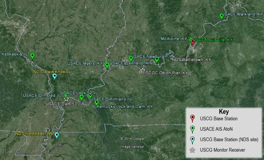
3 LOMA AIS equipment deployment (February 2015) 130+ locations AIS AtoN transceivers Interoperability with USCG
")

4 FY15 Product Development LOMA AIS Coverage (nominal 12nm) LOMA coverage: 3,878 river miles 32% of USACE-maintained 12,000 miles
")
5 USCG AIS coverage Nationwide AIS (NAIS) program

6 Full LOMA Feed

7 Current LOMA Capabilities Lock operator situational display AIS vessel information Zone Management Playback capability
8 AIS System Overview Ship - Ship (Collision avoidance) Mountains Ship - Shore (VTS, Report of Ships) Shore - Ship Traffic Control Station (VTS-Center) Station Ashore


9 Olmsted & LOMA 375 Wide Nav Pass

10 New AIS Information AToN discrepancy Synthetic AIS AToN Virtual AIS AToN Geographic Notices Vessels awaiting lockage Lock status River current Water depth Weather


11 LOMA capabilities: AIS transmit capability Text messages, water levels, weather, geographic notice and other messages Development work with US Coast Guard Build on USCG developments Integrate USACE and USCG AIS capabilities Information transmitted where it s needed, regardless of who operates the transceiver Test beds: Louisville Port of Pittsburgh Lower Ohio River
12 emsi Demonstration What When Distribute electronic Maritime Safety Information (e-msi) information using the Automatic Identification System (AIS) A one-two year demonstration project starting late 2015/early 2016 Where Who Why Along a reach of the Lower Ohio River and adjacent reaches of the Mississippi River upstream and downstream from Cairo. a group of volunteer towboats will be configured to receive and display information transmitted over AIS work with a group of operators during the demonstration to gain practical experience on distributing e-msi via AIS and other means and to learn what benefit system users have gained from the service To establish the coverage of the existing transmitters and determine where there are holes in coverage
13 emsi Transmitters
14 Data Sources Source Information Update Rate USCG AToN Data Base USACE Lock Management Data Base Real, Synthetic, Virtual AIS AToNs Vessels awaiting lockage, Lock status As updated As updated by lock master NOAA Weather Hourly Weather Stations Weather Every minute NOAA/NWS/USACE Water Depth Hourly ORFC Predicted Current Daily Olmsted Notice to Navigation Interest Restricted areas, traffic patterns As needed

15 LOMA - Transmit Additional information provided as overlay to IENC: Weather Water levels Lock status Lock Currents

16 Weather observations via AIS aboard vessel
17 Water Level observations aboard vessel

18 Lock Order Message Used by Saint Lawrence Seaway since 2002 Improves efficiency, lock utilization, mitigates racing & wait time Allows Locks to perform Maintenance based on que Allows industry to save fuel

19 Lock Order via AIS aboard vessel


20 Lock Approach Current Models Develop and run current models Library of output Communicate to users based on real-time conditions Output database Web services Vessel display Model output AIS message (LOMA or USCG) AIS transceiver


21 William Strait

22 Virtual Aid to Navigation


23 Synthetic Buoys Olmsted & 53

24 USCG Districts

25 USCG LNM

26 Synthetic Buoys Olmsted

27 Synthetic Buoys Olmsted

28 Synthetic Buoys Olmsted


29 For more information Michael Winkler
Dissemination of enhanced Marine Safety Information (emsi) via AIS: Requirements for an AIS transmit service
 via AIS: Requirements for an AIS transmit service") Dissemination of enhanced Marine Safety Information (emsi) via AIS: Requirements for an AIS transmit service Brian Tetreault Navigation Systems Specialist US Army Corps of Engineers Engineer Research &
Dissemination of enhanced Marine Safety Information (emsi) via AIS: Requirements for an AIS transmit service Brian Tetreault Navigation Systems Specialist US Army Corps of Engineers Engineer Research &
Maritime Geo-Fence Letter Report
 Report No. CG-D-10-16 Maritime Geo-Fence Letter Report Authors: Irene Gonin and Gregory Johnson Distribution Statement A: Approved for public release; distribution is unlimited. July 2016 Classification
United States Coast Guard Office of Navigation Systems
 United States Coast Guard Office of Navigation Systems Future of Navigation Initiatives & Operations R. David Lewald Program Analyst Navigation Systems Office of Navigation Systems U.S. Coast Guard Washington,
Expanded use of Automatic Identification System (AIS) navigation technology in Vessel Traffic Services (VTS) B. J. Tetreault 1
 navigation technology in Vessel Traffic Services (VTS) B. J. Tetreault 1") Expanded use of Automatic Identification System (AIS) navigation technology in Vessel Traffic Services (VTS) B. J. Tetreault 1 1 (At time of writing) U. S. Coast Guard, Office of Shore Forces (CG-7413),
Expanded use of Automatic Identification System (AIS) navigation technology in Vessel Traffic Services (VTS) B. J. Tetreault 1 1 (At time of writing) U. S. Coast Guard, Office of Shore Forces (CG-7413),
RF Monitoring Service Profile Based on AIS Binary Message
 , pp.55-59 http://dx.doi.org/10.14257/astl.2015.108.13 RF Monitoring Service Profile Based on AIS Binary Message Soyoung Hwang Catholic University of Pusan, 609-757 Busan, South Korea soyoung@cup.ac.kr
USACE AIS Transmit Technical Support Summary Report
 Report No. CD-D-09-15 USACE AIS Transmit Technical Support Summary Report Distribution Statement A: Approved for public release; distribution is unlimited. September 2014 N O T I C E This document is disseminated
Government Agency Perspectives & Initiatives Canadian Coast Guard Laurent Tardif, Director, Safe Shipping
 Unclassified Government Agency Perspectives & Initiatives Canadian Coast Guard Laurent Tardif, Director, Safe Shipping Mariner s Workshop January 23, 2019 1 Overview 1 Context 2 Marine Fees 3 4 5 Update
GUIDANCE FOR THE PRESENTATION AND DISPLAY OF AIS APPLICATION-SPECIFIC MESSAGES INFORMATION
 E 4 ALBERT EMBANKMENT LONDON SE1 7SR Telephone: +44 (0)20 7735 7611 Fax: +44 (0)20 7587 3210 Ref. T2-OSS/2.7.1 SN.1/Circ.290 2 June 2010 GUIDANCE FOR THE PRESENTATION AND DISPLAY OF AIS APPLICATION-SPECIFIC
BookletChart. Sacramento River Sacramento to Fourmile Bend NOAA Chart A reduced-scale NOAA nautical chart for small boaters
 BookletChart Sacramento River Sacramento to Fourmile Bend NOAA Chart 18664 A reduced-scale NOAA nautical chart for small boaters When possible, use the full-size NOAA chart for navigation. Included Area
ITU Service Publications (maritime) and MARS (Maritime mobile Access and Retrieval System)
 and MARS (Maritime mobile Access and Retrieval System)") ITU Service Publications (maritime) and MARS (Maritime mobile Access and Retrieval System) ITU Radiocommunication Bureau Ms. Sujiva Pinnagoda pinnagoda@itu.int BR/TSD/TPR Another BR activity Radiocommunication
ITU Service Publications (maritime) and MARS (Maritime mobile Access and Retrieval System) ITU Radiocommunication Bureau Ms. Sujiva Pinnagoda pinnagoda@itu.int BR/TSD/TPR Another BR activity Radiocommunication
Standard Operating Procedures for: VHF Marine Radio
 Serenity Houseboat I. Overview Standard Operating Procedures for: VHF Marine Radio VHF, or Very High Frequency, marine radio is the standard method of communication between vessels. Marine radio equipment
Digital broadcasting systems under development within ITU-R of interest for the maritime community
 Digital broadcasting systems under development within ITU-R of interest for the maritime community Christian RISSONE ANFR rissone@anfr.fr IHO, WWNWS 5 Monaco, 2 nd October 2013 1 Background for the 500
Report No. CD-D AIS ASM Operational Integration Plan. Distribution Statement A: Approved for public release; distribution is unlimited.
 Report No. CD-D-07-15 AIS ASM Operational Integration Plan Distribution Statement A: Approved for public release; distribution is unlimited. N O T I C E This document is disseminated under the sponsorship
IALA Guideline No. XXXX. The establishment of AIS as an Aid to Navigation. Edition 1.3. [Date] Working vs / Working 7.
![IALA Guideline No. XXXX. The establishment of AIS as an Aid to Navigation. Edition 1.3. [Date] Working vs / Working 7.](/thumbs/74/71399138.jpg "IALA Guideline No. XXXX. The establishment of AIS as an Aid to Navigation. Edition 1.3. [Date] Working vs / Working 7.") ANM12/Output/10 International Association of Marine Aids to Navigation and Lighthouse Authorities AISM Association of Internationale de Signalisation Maritime IALA IALA Guideline No. XXXX On The establishment
ANM12/Output/10 International Association of Marine Aids to Navigation and Lighthouse Authorities AISM Association of Internationale de Signalisation Maritime IALA IALA Guideline No. XXXX On The establishment
BookletChart. Sacramento River Andrus Island to Sacramento NOAA Chart A reduced-scale NOAA nautical chart for small boaters
 BookletChart Sacramento River Andrus Island to Sacramento NOAA Chart 18662 A reduced-scale NOAA nautical chart for small boaters When possible, use the full-size NOAA chart for navigation. Included Area
ESA IAP Blue Belt demonstration project:
 Page 1 ESA IAP Blue Belt demonstration project: supporting the European Maritime Safety Agency (EMSA) Blue Belt Project, by providing a service based on satellite based AIS data complementing the terrestrial
Challenges and opportunities in the e-navigation Development. Actual projects.
 Challenges and opportunities in the e-navigation Development. Actual projects. John Erik Hagen, Regional Director Oslo, September 2018 What is e-navigation? Efficient transfer of marine information and
Automatic Identification System And Its Integration On The Great Lakes And St. Lawrence Seaway
 I Automatic Identification System And Its Integration On The Great Lakes And St. Lawrence Seaway Prepared by Melissa Hopkins - 20010575 Adam Howell - 20001016 David Ingram - 20001119 Andrew Wakeham - 20010422
JOURNAL OF MARITIME RESEARCH. The Architecture of Data Transmission in Inland Navigation
 JOURNAL OF MARITIME RESEARCH Vol XI. No. II (2014) pp 3 7 ISSN: 1697-4040, www.jmr.unican.es The Architecture of Data Transmission in Inland Navigation A. Lisaj 1,2, and P. Majzner 3 ARTICLE INFO Article
Western Region enavigation Sub- Committee Report
 Western Region enavigation Sub- Committee Report Western Region enavigation meeting - Jan 12 18 BC Ferries BC Coast Pilots BCIT Marine Campus Canadian Coast Guard Canadian Hydrographic Services Canadian
GALVESTON - BOLIVAR FERRY SYSTEM. ITS Implementations
 GALVESTON - BOLIVAR FERRY SYSTEM ITS Implementations Presentation Outline ITS Implementations at the Galveston Ferry History of the Galveston Ferry System Closed Circuit Television Cameras Communications
Civil GPS Service Interface Committee (CGSIC) International Committee on GNSS November 2016
 International Committee on GNSS November 2016") Civil GPS Service Interface Committee (CGSIC) International Committee on GNSS 06-11 November 2016 Russell Holmes CGSIC Deputy Chair U.S. Coast Guard Navigation Center 30 th Anniversary of the CGSIC CGSIC
Civil GPS Service Interface Committee (CGSIC) International Committee on GNSS 06-11 November 2016 Russell Holmes CGSIC Deputy Chair U.S. Coast Guard Navigation Center 30 th Anniversary of the CGSIC CGSIC
Doug Miller Milltech Marine Inc. Milltech Marine 1
 Doug Miller Milltech Marine Inc. www.milltechmarine.com Milltech Marine 1 What I ll Cover What is AIS? AIS Transponders AIS Receivers Typical Usage Scenarios What s new and what s coming Questions Milltech
Recent Developments in NOAA s Real- Time Coastal Observing Systems for Safe and Efficient Maritime Transportation
 Recent Developments in NOAA s Real- Time Coastal Observing Systems for Safe and Efficient Maritime Transportation Rich Edwing, Director NOAA Center for Operational Oceanographic Products and Services CMTS
The Future for the AIS AtoN. Michael Card Zeni Lite Buoy Co., Ltd., Japan
 The Future for the AIS AtoN Michael Card Zeni Lite Buoy Co., Ltd., Japan History Early work in USA and Europe Not compatible with UAIS First UAIS AIS AtoN was Akari-400 Launched at IALA Sydney, 8 years
BookletChart. Chesapeake Bay Pocomoke and Tangier Sounds NOAA Chart A reduced-scale NOAA nautical chart for small boaters
 BookletChart Chesapeake Bay Pocomoke and Tangier Sounds NOAA Chart 12228 A reduced-scale NOAA nautical chart for small boaters When possible, use the full-size NOAA chart for navigation. Published by the
IHO Colours & Symbols Maintenance Working Group (C&SMWG) 15th Meeting, BSH, Rostock, Germany, 2-4 May 2005
 15th Meeting, BSH, Rostock, Germany, 2-4 May 2005") CSMWG15-INF2 IHO Colours & Symbols Maintenance Working Group (C&SMWG) 15th Meeting, BSH, Rostock, Germany, 2-4 May 2005 Ref: HA405/004/033-01 NOTE: this is an internal document of the UKHO and is supplied
CSMWG15-INF2 IHO Colours & Symbols Maintenance Working Group (C&SMWG) 15th Meeting, BSH, Rostock, Germany, 2-4 May 2005 Ref: HA405/004/033-01 NOTE: this is an internal document of the UKHO and is supplied
VHF Data Exchange System (VDES)
") VHF Data Exchange System (VDES) ETSI Workshop Future Evolution of Marine Communication 7-8 November 2017 Malcolm Lyman Marketing Manager CML Microcircuits UK With acknowledgments to the members of IALA
VHF Data Exchange System (VDES) ETSI Workshop Future Evolution of Marine Communication 7-8 November 2017 Malcolm Lyman Marketing Manager CML Microcircuits UK With acknowledgments to the members of IALA
CO-OPS Current Sensors Data Telemetry and Formatting
 CO-OPS Current Sensors Data Telemetry and Formatting NOAA/NOS Center for Operational Oceanographic Products and Services User Report IHO Currents Working Group June, 2014 Program Elements 2 Physical Oceanographic
SECTION IV - DISCREPANCIES
 SECTION IV - DISCREPANCIES INTRODUCTION: An important aspect of the Auxiliary ATON/CU Program includes the methods and procedures for informing the proper Government agencies of findings. An Auxiliary
FOREWORD. IHO S-100 Working Group
 IHO International Hydrographic Organization KHOA Korea Hydrographic and Oceanographic Agency MUCH MORE THAN JUST NAUTICAL CHARTS IHO UNIVERSAL HYDROGRAPHIC data MODEL This document was produced with the
JCG GMDSS Symposium NAVDAT : Navigational Data
 JCG GMDSS Symposium 2013 NAVDAT : Navigational Data - System Presentation - Pascal OLIVIER NAVDAT Presentation Page 1/35 From analog to digital in maritime radio communications The current analog radio
Integration of AIS functionalities
 Integration of AIS functionalities by John O. Klepsvik FARGIS 05 March 01, 2005 WORLD CLASS through people, technology and dedication WORLD CLASS through people, technology and dedication KONGSBERG March
ESSnet pilot AIS data. Anke Consten, Eleni Bisioti and Olav Grøndal (23 February 2017, Sofia)
") ESSnet pilot AIS data Anke Consten, Eleni Bisioti and Olav Grøndal (23 February 2017, Sofia) Overview 1. Introduction 2. Deliverables ESSnet pilot AIS data 3. Data access and handling 4. Quality of AIS
ESSnet pilot AIS data Anke Consten, Eleni Bisioti and Olav Grøndal (23 February 2017, Sofia) Overview 1. Introduction 2. Deliverables ESSnet pilot AIS data 3. Data access and handling 4. Quality of AIS
INVENTORY FOR HARMONISED INLAND AIS APPLICATION SPECIFIC MESSAGES IN EUROPE
 INVENTORY FOR HARMONISED INLAND AIS APPLICATION SPECIFIC MESSAGES IN EUROPE GUIDELINES OF THE VTT EXPERT GROUP Edition 1.2 Version: 12-07-2017 Author: Vessel Tracking and Tracing Expert Group TABLE OF
American Marine Training Center, LLC AMTC (2682)
") American Marine Training Center, LLC www.americanmarinetc.com 1-855-344-AMTC (2682) (This is the FCC Commercial Element 7R Question Pool. It has been edited to make it more user friendly to assist as a
American Marine Training Center, LLC www.americanmarinetc.com 1-855-344-AMTC (2682) (This is the FCC Commercial Element 7R Question Pool. It has been edited to make it more user friendly to assist as a
Fisheries and Marine Resources (Automatic Identification System) Regulations
 Regulations") Fisheries and Marine Resources (Automatic Identification System) Regulations 2016 GN No. 116 of 2016 Government Gazette of Mauritius No. 47of 28 May 2016 THE FISHERIES AND MARINE RESOURCES ACT Regulations
Fisheries and Marine Resources (Automatic Identification System) Regulations 2016 GN No. 116 of 2016 Government Gazette of Mauritius No. 47of 28 May 2016 THE FISHERIES AND MARINE RESOURCES ACT Regulations
IALA S WORK IN E-NAVIGATION. Michael Card
 IALA S WORK IN E-NAVIGATION Michael Card e-navigation origins The early work of IALA on e-navigation Multiple Initiatives EfficienSea 2 STM Validation IHO S-100 and IALA S-200 Smart Navigation VDES development
Using AIS to identify and investigate ferry accidents
 Using AIS to identify and investigate ferry accidents David Hewson Antenna Network Manager Genscape Vesseltracker info@genscape.com DE: +49 (0) 97 07 86 10 EU: +31 20 524 4089 Background Vesseltracker
AAPSilver System Performance Validation
 Report No. CG-D-04-13 AAPSilver System Performance Validation Distribution Statement A: Approved for public release; distribution is unlimited. 1 N O T I C E This document is disseminated under the sponsorship
COMMUNICATIONS FOR MARITIME SAFETY AND EFFICIENCY. Francis Zachariae, Secretary-General, IALA
 COMMUNICATIONS FOR MARITIME SAFETY AND EFFICIENCY Francis Zachariae, Secretary-General, IALA IALA and its Purpose Non profit, international technical association established in 1957 Two Goals aimed at
1
 12/20/2016 www.made-simplefor-cruisers.com 1 Emergency Position Indicating Radio Beacons (EPIRB) Only 406.0-406.1 EPIRBs with a built in GPS will be authorized for sale in the US. EPIRBs without position
RESOLUTION MSC.278(85) (adopted on 1 December 2008) ADOPTION OF THE NEW MANDATORY SHIP REPORTING SYSTEM "OFF THE COAST OF PORTUGAL - COPREP"
 (adopted on 1 December 2008) ADOPTION OF THE NEW MANDATORY SHIP REPORTING SYSTEM OFF THE COAST OF PORTUGAL - COPREP") MSC 85/26/Add.1 RESOLUTION MSC.278(85) SYSTEM OFF THE COAST OF PORTUGAL COPREP THE MARITIME SAFETY COMMITTEE, RECALLING Article 28 of the Convention on the International Maritime Organization concerning
MSC 85/26/Add.1 RESOLUTION MSC.278(85) SYSTEM OFF THE COAST OF PORTUGAL COPREP THE MARITIME SAFETY COMMITTEE, RECALLING Article 28 of the Convention on the International Maritime Organization concerning
Results of the AIS AtoN International Survey Conducted by the Canadian Coast Guard November 2016
 Results of the AIS AtoN International Survey Conducted by the Canadian Coast Guard November 2016 Canadian Context 113 shore based stations including 2 sites in the Arctic. 2 Canadian Context Canada is
BookletChart. Intracoastal Waterway Grassy Key to Bahia Honda Key NOAA Chart A reduced-scale NOAA nautical chart for small boaters
 BookletChart Intracoastal Waterway Grassy Key to Bahia Honda Key NOAA Chart 11453 A reduced-scale NOAA nautical chart for small boaters When possible, use the full-size NOAA chart for navigation. Published
PRODUCTS AND SERVICES FOR THE MARITIME COMMUNITY. Ed Martin, Chief Customer Affairs Branch Navigation Services Division Monday, 27 October, 2008
 PRODUCTS AND SERVICES FOR THE MARITIME COMMUNITY Ed Martin, Chief Customer Affairs Branch Navigation Services Division Monday, 27 October, 2008 Coral Reef Conservation International Collaboration Marine
INFORMATION PAPER ON AIS AIDS TO NAVIGATION REPORT MESSAGES IN INLAND WATERWAYS
 INFORMATION PAPER ON AIS AIDS TO NAVIGATION REPORT MESSAGES IN INLAND WATERWAYS Edition 1.1 Version: 09-05-2017 Author: Inland ECDIS Expert Group and Vessel Tracking and Tracing Expert Group VTT / IECDIS
Lakes and Rivers Division, David Dale
 Locks and Dams 2, 3, and 4 Monongahela River, PA (Lower Mon Project) Inland Waterways Users Board Lakes and Rivers Division, David Dale November 2014 David Dale, PE, PMP Braddock Dam US Army Corps of Engineers
RIS in Germany. RIS week Berlin.
 RIS in Germany RIS week 2014 Berlin www.bmvi.de Main Waterways in Germany The German Waterway and Shipping Administration maintains 23,000 km² maritime waterways 7,300 km inland waterways 5,100 km main
L AGENCE NATIONALE DES FREQUENCES (ANFR) From Titanic to satellite from Morse to digital Entry in a new era for the maritime community
 From Titanic to satellite from Morse to digital Entry in a new era for the maritime community") L AGENCE NATIONALE DES FREQUENCES (ANFR) From Titanic to satellite from Morse to digital Entry in a new era for the maritime community ITU regional seminar 6-8 June 2018 St-Petersburg, Russian Federation
L AGENCE NATIONALE DES FREQUENCES (ANFR) From Titanic to satellite from Morse to digital Entry in a new era for the maritime community ITU regional seminar 6-8 June 2018 St-Petersburg, Russian Federation
Trusted for Life TM. USCG AIS Mandate. 3 rd December 10:30 am - 11:15 am
 Trusted for Life TM USCG AIS Mandate 3 rd December 10:30 am - 11:15 am The AIS Mandate McMurdo Stand 2335 CEO McMurdo UK McMurdo By the Numbers 25% Percentage of world s 406MHz beacons manufactured by
CHAPTER 6 LONG RANGE NAVIGATIONAL AIDS PART I LORAN-C
 CHAPTER 6 LONG RANGE NAVIGATIONAL AIDS PART I LORAN-C 600A. Acronyms.............................................................................. 6-3 600B. Definitions.............................................................................
OPERATIONS SEAFARER CERTIFICATION GUIDANCE NOTE SA MARITIME QUALIFICATIONS CODE SHORT RANGE CERTIFICATE (SRC)
") Page 1 of 8 Compiled by Chief Examiner Approved by Senior Radio Examiner OPERATIONS SEAFARER CERTIFICATION GUIDANCE NOTE SA MARITIME QUALIFICATIONS CODE SHORT Page 2 of 8 SHORT : OUTLINE EXAMINATION SYLLABUS
Page 1 of 8 Compiled by Chief Examiner Approved by Senior Radio Examiner OPERATIONS SEAFARER CERTIFICATION GUIDANCE NOTE SA MARITIME QUALIFICATIONS CODE SHORT Page 2 of 8 SHORT : OUTLINE EXAMINATION SYLLABUS
e-navigation Progress and trends: the IHO perspective
 International Hydrographic Organization e-navigation Progress and trends: the IHO perspective Gilles Bessero Director, IHO International Hydrographic Organization Intergovernmental consultative and technical
ROUTEING OF SHIPS, SHIP REPORTING AND RELATED MATTERS. Establishment of a Mandatory Ship Reporting System in the
 INTERNATIONAL MARITIME ORGANIZATION E SUB-COMMITTEE ON SAFETY OF NAVIGATION 48th session Agenda item 3 IMO NAV 48/3/2 11 April 2002 Original: ENGLISH ROUTEING OF SHIPS, SHIP REPORTING AND RELATED MATTERS
DOWNLOAD OR READ : THE NAUTICAL CHART PDF EBOOK EPUB MOBI
 DOWNLOAD OR READ : THE NAUTICAL CHART PDF EBOOK EPUB MOBI Page 1 Page 2 the nautical chart the nautical chart pdf the nautical chart NOAA ENCs (ENC): Vector files of chart features and available in S-57
Functional Requirements Study
 Report No. CG-D-01-09 Functional Requirements Study Pre-Phase I Final Report Distribution: This document is available to the U.S. public through the National Technical Information Service, Springfield,
IMO. Resolution A.954(23) Adopted on 5 December 2003 (Agenda item 17) PROPER USE OF VHF CHANNELS AT SEA
 Adopted on 5 December 2003 (Agenda item 17) PROPER USE OF VHF CHANNELS AT SEA") INTERNATIONAL MARITIME ORGANIZATION E IMO ASSEMBLY 23rd session Agenda item 17 A 23/Res.954 26 February 2004 Original: ENGLISH Resolution A.954(23) Adopted on 5 December 2003 (Agenda item 17) PROPER USE
INTERNATIONAL MARITIME ORGANIZATION E IMO ASSEMBLY 23rd session Agenda item 17 A 23/Res.954 26 February 2004 Original: ENGLISH Resolution A.954(23) Adopted on 5 December 2003 (Agenda item 17) PROPER USE
New advanced real time smart Search and Rescue RADAR Transponder (SART)
") Current Science International Volume : 07 Issue : 02 April- June 2018 Pages: 128-134 New advanced real time smart Search and Rescue RADAR Transponder (SART) M. S. Zaghloul Electronics and Communication
Current Science International Volume : 07 Issue : 02 April- June 2018 Pages: 128-134 New advanced real time smart Search and Rescue RADAR Transponder (SART) M. S. Zaghloul Electronics and Communication
Automatic identification system VHF data link loading
 Report ITU-R M.2287-0 (12/2013) Automatic identification system VHF data link loading M Series Mobile, radiodetermination, amateur and related satellite services ii Rep. ITU-R M.2287-0 Foreword The role
DISC Ukrainian National Status Report
 DISC 2016 Ukrainian National Status Report NU OMA, prof.doct.tech Igor Gladkykh phone +380503909586 e-mail:gladkykh958@gmail.com Nick Golodov Hydrography Service of Ukraine phone +380444256874 e-mail:
SAFETY EQUIPMENT AND PREPARATION. S/V Odette USA 5619
 SAFETY EQUIPMENT AND PREPARATION S/V Odette USA 5619 Odette5619@gmail.com COMMUNICATION PREPARATION Dedicate dock time for crew to familiarize themselves with all communication equipment: VHF: Walk through
E-NAVIGATION AND BEYOND
 E-NAVIGATION AND BEYOND The Work of IALA e-navigation Committee and Future CDR. Hideki NOGUCHI, Chair, IALA ENAV Committee e-navigation (ENAV) Committee Established in 2010 by merging R-NAV and AIS Committee
Using a Pilot Laptop with the AIS pilot plug - observed errors and difficulties
 Using a Pilot Laptop with the AIS pilot plug - observed errors and difficulties 2 nd November 2008 The following pages and images detail the errors found and experience in using his Pilot Laptop by a Australian
The human touch in technology. ECDIS ECS Conning screen Ship speed info system
 The human touch in technology ECDIS ECS Conning screen Ship speed info system Alphatron ALPHACHART T ECDIS Type approved ECDIS system powered by TRANSAS The ALPHACHART T is an advanced Electronic Chart
LT Matthew Forney, NOAA Navigation Manager Alaska Region Bering Strait MaritimeSymposium. Office of Coast Survey
 NOAA LT Matthew Forney, NOAA Navigation Manager Alaska Region Bering Strait MaritimeSymposium Who is Coast Survey? First science agency of the U.S. Formed in 1807 Responsible for surveying 3.4 million
Weatherdock explains: How does real DSC work in an emergency transmitter?
 explains: How does real DSC work in an emergency transmitter? 1 DSC Basics 2 AIS S.A.R.T. & DSC easyrescue-pro 3 DSC closed loop 4 DSC open loop 1 DSC Basics DSC is short cut for Digital Selective Call
BookletChart. St. Joseph and Benton Harbor NOAA Chart A reduced-scale NOAA nautical chart for small boaters
 BookletChart St. Joseph and Benton Harbor NOAA Chart 14930 A reduced-scale NOAA nautical chart for small boaters When possible, use the full-size NOAA chart for navigation. Included Area Published by the
Global Maritime Distress and Safety System (GMDSS)
") Global Maritime Distress and Safety System (GMDSS) Global Maritime Distress and Safety System (GMDSS) BACKGROUNG, APPLICATION, DEFINITION GMDSS (Background) SOLAS 74 Ships 1600 TRG Radio Installation Ships
Global Maritime Distress and Safety System (GMDSS) Global Maritime Distress and Safety System (GMDSS) BACKGROUNG, APPLICATION, DEFINITION GMDSS (Background) SOLAS 74 Ships 1600 TRG Radio Installation Ships
Rutter High Resolution Radar Solutions
 Rutter High Resolution Radar Solutions High Resolution Imagery, Target Detection, and Tracking At the core of our enhanced radar capabilities are proprietary radar processing and imaging technologies.
IMO ACTIVITIES AFFECTING HSSC
 HSSC1-04.2A rev3 1 st HSSC MEETING Singapore, 22-24 October 2009 Paper for Consideration by HSSC IMO ACTIVITIES AFFECTING HSSC Submitted by: Executive Summary: Related Documents: IHB This paper summarizes
Demonstrator of a Data Processing Centre (DPC) for satellite-based AIS services
 for satellite-based AIS services") Page 1 Demonstrator of a Data Processing Centre (DPC) for satellite-based AIS services 19/20 April 2012 gfabritius@cls.fr Overview of the presentation Page 2 Introducing CLS Introducing AIS / SAT-AIS Scope
Page 1 Demonstrator of a Data Processing Centre (DPC) for satellite-based AIS services 19/20 April 2012 gfabritius@cls.fr Overview of the presentation Page 2 Introducing CLS Introducing AIS / SAT-AIS Scope
Analysis of the Royal Majesty Grounding Using SOL
 Analysis of the Royal Majesty Grounding Using SOL Claire Blackett The Intelligent Information Retrieval Group, University College Dublin, Ireland 3 rd Bieleschweig Workshop on Systems Engineering Overview
HIGH PERFORMANCE MARITIME. em-trak S100 PRODUCTS. Antenna splitter. Product Manual. High Performance Maritime Products
 em-trak S100 MARITIME PRODUCTS HIGH PERFORMANCE Antenna splitter Product Manual High Performance Maritime Products www.em-trak.com 201-0206:3 Contents 1 - Notices...1 1.1 - Safety warnings...1 1.2 - General
Tide & Meteorological Data over AIS
 Tide & Meteorological Data over AIS E.F.Read (Ohmex Ltd) & W.S.Heaps (ABP Ltd) THSUK Hydro8 1 Background to AIS Most significant development since RADAR Positions and Timing from GPS network 12.5 Watt
MARINE ELECTRONIC HIGHWAY IN STRAITS OF MALACCA AND SINGAPORE. Development of Supporting Element for Future & Sustainable Operation
 COOPERATION FORUM UNDER THE COOPERATIVE MECHANISM ON SAFETY OF NAVIGATION AND ENVIRONMENTAL PROTECTION IN THE STRAITS OF MALACCA AND SINGAPORE 7th SESSION Agenda Item... CF 7/... 22-23 September 2014 Original.
THE ELECTRONIC CHART DISPLAY AND INFORMATION SYSTEM (ECDIS) IN CHINA
 IN CHINA") International Hydrographic 'Review, Monaco, LXIX(2), September 1992 THE ELECTRONIC CHART DISPLAY AND INFORMATION SYSTEM (ECDIS) IN CHINA by The Research Group on ECDIS 1 Abstract This paper presents a
International Hydrographic 'Review, Monaco, LXIX(2), September 1992 THE ELECTRONIC CHART DISPLAY AND INFORMATION SYSTEM (ECDIS) IN CHINA by The Research Group on ECDIS 1 Abstract This paper presents a
Inland Waterways Users Board #60. Inland Navigation R&D
 Inland Waterways Users Board #60 Inland Navigation R&D 19 February 2009 Vicksburg, MS Agenda 0845-0900 Welcome Dr. Jeff Holland 0900 0920 Agenda & Navigation R&D Overview Mr. Jeff Lillycrop 0920-0940 Mississippi
ANNUAL OF NAVIGATION 19/2012/part 1
 ANNUAL OF NAVIGATION 19/2012/part 1 PAWEŁ BANYŚ, THORALF NOACK, STEFAN GEWIES German Aerospace Center (DLR), Institute of Communications and Navigation (IKN) ASSESSMENT OF AIS VESSEL POSITION REPORT UNDER
This circular summarizes the various important aspects of the LRIT system with a view to enabling companies to ensure compliance in a timely manner.
 Luxembourg, 29/10/2008 CIRCULAR CAM 02/2008 N/Réf. : AH/63353 Subject : Long-Range Identification and Tracking of Ships (LRIT) To : All ship owners, ship operators and designated persons of Luxembourg
VHF 110/210 AIS Series. Owner s Manual
 VHF 110/210 AIS Series Owner s Manual Table of Contents Introduction...1 Radio Overview... 1 Handset Overview... 1 Home Screen... 1 System Status Icons... 1 Basic Operation... 2 Turning On and Off the
PAGE 1. Krzysztof Bronk, PhD
 PAGE 1 Krzysztof Bronk, PhD Deputy Manager Wireless Systems and Networks Department National Institute of Telecommunications (NIT), Poland e-mail: K.Bronk@itl.waw.pl Presentation outline PAGE 2 Introduction
ATTACHMENT E. How to Conduct a GMDSS Inspection.
 Page 1 of 7 NOTE: This document is an excerpt from The Report and Order In the Matter of Amendment of the Commission's Rules Concerning the Inspection of Radio Installations on Large Cargo and Small Passenger
Universal Shipborne Automatic Identification System (AIS) Transponder
 Transponder") Universal Shipborne Automatic Identification System (AIS) Transponder What is an AIS? Picture a shipboard radar display, with overlaid electronic chart data, that includes a mark for every significant
Universal Shipborne Automatic Identification System (AIS) Transponder What is an AIS? Picture a shipboard radar display, with overlaid electronic chart data, that includes a mark for every significant
It is an Interconnected World. Except in the Maritime Domain In 2008 Satellite AIS (S-AIS) Changed All that!
 Changed All that!") It is an Interconnected World Except in the Maritime Domain In 2008 Satellite AIS (S-AIS) Changed All that! Background This brief is the result of that Research, which continues to this day. Makes Regional
It is an Interconnected World Except in the Maritime Domain In 2008 Satellite AIS (S-AIS) Changed All that! Background This brief is the result of that Research, which continues to this day. Makes Regional
HDD Wire Guided Waterway Crossing ATON Plan. Youghiogheny River (S122)
") HDD Wire Guided Waterway Crossing ATON Plan Youghiogheny River (S122) Mariner East Phase 2 Pipeline Project Prepared for: Sunoco Pipeline, L.P. 535 Friztown Road Sinking Springs, PA 19608 Prepared by:
HDD Wire Guided Waterway Crossing ATON Plan Youghiogheny River (S122) Mariner East Phase 2 Pipeline Project Prepared for: Sunoco Pipeline, L.P. 535 Friztown Road Sinking Springs, PA 19608 Prepared by:
IMO/IHO World-wide Navigational Warning Service (WWNWS)
") IMO/IHO World-wide Navigational Warning Service (WWNWS) 1 WWNWS 1972 PROPOSAL TO SET UP AN Ad Hoc IHO/IMO COMMITTEE TO DEVELOP AN INTER- NATIONALLY CO-ORDINATED SYSTEM FOR PROMULGATING LONG RANGE NAVIGATIONAL
IMO/IHO World-wide Navigational Warning Service (WWNWS) 1 WWNWS 1972 PROPOSAL TO SET UP AN Ad Hoc IHO/IMO COMMITTEE TO DEVELOP AN INTER- NATIONALLY CO-ORDINATED SYSTEM FOR PROMULGATING LONG RANGE NAVIGATIONAL
FURUNO DEEPSEA WORLD Class-A Universal AIS Automatic Identification System. The future today with FURUNO's electronics technology.
 R FURUNO DEEPSEA WORLD Class-A Universal AIS Automatic Identification System Model FA-100 The AIS improves the safety of navigation by assisting in the efficient navigation of ships, protection of the
IMO ANY OTHER BUSINESS. Progress on standards development by the IEC. Submitted by the International Electrotechnical Commission
 INTERNATIONAL MARITIME ORGANIZATION E IMO SUB-COMMITTEE ON SAFETY OF NAVIGATION 54th session Agenda item 24 NAV 54/24/1 16 April 2008 Original: ENGLISH ANY OTHER BUSINESS Progress on standards development
GMDSS communication systems
 GMDSS Basic Concepts A System Overview Functional requirements The GMDSS (Global Maritime Distress and Safety System) is specifically designed to automate a ship's radio distress alerting function, and,
Recent developments in Portable Pilot Units and e-navigation Mariners Workshop 2016, Montreal
 Recent developments in Portable Pilot Units and e-navigation Mariners Workshop 2016, Montreal Presentation objectives by regions PPU systems and e-nav tools used in Canada by pilots Regional developments
Space-Based AIS: Contributing to Global Safety and Security
 Space-Based AIS: Contributing to Global Safety and Security J.S. Cain 1, E. Meger 2, COM DEV Limited 155 Sheldon Ave, Cambridge, Ontario, Canada. Abstract Global trade continues to increase and today more
AIS Training. AIS Technology in Digital Yacht Products Explained. Digital Yacht Ltd TEL
 AIS Training AIS Technology in Digital Yacht Products Explained Digital Yacht Ltd www.digitalyacht.co.uk TEL + 44 1179 554474 What is AIS? The Automatic Identification System (AIS) is the biggest advance
ROUTEING OF SHIPS, SHIP REPORTING AND RELATED MATTERS. New traffic separation schemes and two-way routes in Norra Kvarken
 E SUB-COMMITTEE ON SAFETY OF NAVIGATION 57th session Agenda item 3 NAV 57/3/7 11 March 2011 Original: ENGLISH ROUTEING OF SHIPS, SHIP REPORTING AND RELATED MATTERS New traffic separation schemes and two-way
Notice to Mariner No. 213
 To : Attn: From: All Agents, Bunkering Companies, Coast Guard, National Transport Authority, Hydrographic Office Operations Manager Capt. Tamer Masoud Harbour Master Facsimile No.: City: Fujairah Country:
Programmatic Updates & Perspectives Julie Thomas Executive Director, SCCOOS
 Programmatic Updates & Perspectives Julie Thomas Executive Director, SCCOOS Board of Governors Meeting Hyperion Water Reclamation Plant Los Angeles December 3,2015 Southern California Coastal Ocean Observing
Pioneer Array Micro-siting Meeting
 Ocean Observatories Initiative Pioneer Array Micro-siting Meeting June 7, 2011 Coastal Institute University of Rhode Island June 7, 2011 PIONEER ARRAY MICRO-SITING MEETING AGENDA Welcome, Introduction
Measuring Currents from Aids-to-Navigation Buoys
 Measuring Currents from Aids-to-Navigation Buoys Recent Design Improvements Bob Heitsenrether Kate Bosley, PhD Kasey Hall Overview CO-OPS Background NOAA s Physical Oceanographic Real-time System (PORTS
Bill Kautz U.S. Coast Guard Telecommunications Manager IALA e NAV Committee AIS/COMMS WG Vice Chair
 Bill Kautz U.S. Coast Guard Telecommunications Manager IALA e NAV Committee AIS/COMMS WG Vice Chair Discussion WRC 12 Results WRC 15 Agenda Item 1.16 Resolution 360 (WRC 12) ITU R WP5B VHF Data Exchange
RESOLUTION MSC.229(82) (adopted on 5 December 2006) ADOPTION OF A NEW MANDATORY SHIP REPORTING SYSTEM "IN THE GALAPAGOS PARTICULARLY SENSITIVE SEA
 (adopted on 5 December 2006) ADOPTION OF A NEW MANDATORY SHIP REPORTING SYSTEM IN THE GALAPAGOS PARTICULARLY SENSITIVE SEA") MSC 82/24/Add.2 RESOLUTION MSC.229(82) IN THE GALAPAGOS PARTICULARLY SENSITIVE SEA AREA (PSSA) (GALREP) THE MARITIME SAFETY COMMITTEE, RECALLING Article 28(b) of the Convention on the International Maritime
MSC 82/24/Add.2 RESOLUTION MSC.229(82) IN THE GALAPAGOS PARTICULARLY SENSITIVE SEA AREA (PSSA) (GALREP) THE MARITIME SAFETY COMMITTEE, RECALLING Article 28(b) of the Convention on the International Maritime