Geophysical Survey Rock Hill Bleachery TBA Site Rock Hill, South Carolina EP-W EPA, START 3, Region 4 TABLE OF CONTENTS Section Page Signature
|
|
|
- Marybeth McCarthy
- 5 years ago
- Views:
Transcription
1 Geophysical Survey Rock Hill Bleachery TBA Site Rock Hill, South Carolina EP-W EPA, START 3, Region 4 Prepared for: Tetra Tech EM, Inc. October 12, 2012
2 Geophysical Survey Rock Hill Bleachery TBA Site Rock Hill, South Carolina EP-W EPA, START 3, Region 4 TABLE OF CONTENTS Section Page Signature Page... ii Executive Summary... iii 1.0 Introduction Background Equipment and Methodology CMD EM61-MK Radio Frequency EM Utility Locating Equipment X3M GPR Field Procedures Data Interpretation and Results... 6 Figures Figure 1 CMD-4 Conductivity data Figure 2 CMD-4 In-phase data Figure 3 EM61-MK2 data Figure 4 Site map and data interpretation (Whole site, 1 = 200 Scale) Figure 5 Site map and data interpretation (Northern part of the site, 1 = 100 Scale) Figure 6 Site map and data interpretation (Central part of the site, 1 = 100 Scale) Figure 7 Site map and data interpretation (Southern part of the site, 1 = 100 Scale)

3 Signature Page This report, entitled Geophysical Survey, Rock Hill Bleachery TBA Site, Rock Hill, South Carolina has been prepared for Tetra Tech EM, Inc. located in Duluth, Georgia. It has been prepared under the supervision of Mr. Jorgen Bergstrom at the request of and for the exclusive use of Tetra Tech EM, Inc. This report has been prepared in accordance with accepted quality control practices and has been reviewed by the undersigned. GEL Geophysics, LLC A Member of the GEL Group, Inc. Jorgen Bergstrom Senior Geophysicist John Reynolds Geophysics Specialist Scott D. Carney, P.E. Director October 12, 2012 Date ii
4 Geophysical Survey Rock Hill Bleachery TBA Site Rock Hill, South Carolina EP-W EPA, START 3, Region 4 EXECUTIVE SUMMARY GEL Geophysics performed a geophysical survey at the Rock Hill Bleachery TBA Site in Rock Hill, South Carolina on October 1-5, This investigation was performed for Tetra Tech EM Inc. (Tetra Tech) to aid in characterizing the subsurface at the site. The investigation entailed the collection, processing, presentation, and interpretation of Electromagnetic (EM) and Ground Penetrating Radar (GPR) data. The objectives of the geophysical investigation were to determine the location of buried objects, cables, pipes and the depth and dimension of underground storage tanks, vaults and other buried structures. For this investigation GEL Geophysics used a GF Instruments CMD-4 EM ground conductivity and magnetic susceptibility instrument, a Geonics EM61-MK2 time domain EM system, MALA GeoScience X3M GPR system equipped with 250 MHz antennas, and RadioDetection RD 8000 and Pipehorn 800 radio frequency electromagnetic (RFEM) pipe and cable locators. Positioning data was provided by a Trimble 5800 Real Time Kinematic Global Positioning System (RTK/GPS) system and a TopCon GMS-2 GPS+GLONASS L1 system with a PG-A5 external GPS antenna. Due to site conditions not conducive for GPR signal propagation, GEL Geophysics relied heavily on EM methods for detecting subsurface features at the site. CMD 4 data was collected across the whole site with a 20-foot profile separation. EM61-MK2 data was then collected with a 3-foot profile separation in areas with high concentration of subsurface anomalies. GPR was used on concrete surfaces since the concrete was found to contain reinforcement bars or wire mesh and EM methods cannot detect features below reinforced concrete iii
5 The results of the geophysical survey produced a large number of anomalies. A large number of unknown underground utilities were detected at the site; however, it could not be determined if these utilities were abandoned or active. Thirty areas were detected which exhibit geophysical anomaly responses consistent with underground storage tanks, concrete vaults or concrete foundations. Approximately 300 objects up to 4 by 4 feet in size and less than 3 feet deep were detected across the site. These objects are likely larger chunks of building debris from the razed buildings. An estimated 2,000 smaller and/or deeper objects were also detected in the data sets but were not marked on any attached figure. There is a possibility that other subsurface features may exist at the project site that are not detectable by the geophysical systems due to either subsurface soil conditions or the occurrence of features below the signal penetration depth. To confirm the existence, exact location, and dimensions of features, GEL Geophysics suggests they be probed for verification. iv
6 Geophysical Survey Rock Hill Bleachery TBA Site Rock Hill, South Carolina EP-W EPA, START 3, Region INTRODUCTION GEL Geophysics performed a geophysical survey at the Rock Hill Bleachery TBA Site in Rock Hill, South Carolina on October 1-5, This investigation was performed for Tetra Tech EM Inc. (Tetra Tech) to aid in characterizing the subsurface at the site in advance of soil testing and remediation efforts. 1.1 Background Tetra Tech is currently involved in environmental site investigations at the Rock Hill Bleachery TBA Site in Rock Hill, South Carolina. These investigations involve assessing soil contamination at the approximately 24-acre site. To support this investigation, Tetra Tech invited GEL Geophysics to conduct a geophysical investigation of the site using Electromagnetic (EM) and Ground Penetrating Radar (GPR) and techniques. The objectives of the geophysical investigation were to determine the location of buried objects, cables, pipes and the depth and dimension of underground storage tanks, vaults and other buried structures. This investigation entailed the collection, processing, presentation, and interpretation of geophysical data. 2.0 EQUIPMENT AND METHODOLOGY The following is a brief introduction of the various geophysical equipment used at the site. 2.1 CMD-4 CMD 4 measures variations in electrical conductivity and magnetic susceptibility of subsurface materials. The conductivity is determined by inducing a primary
7 Geophysical Survey Rock Hill Bleachery TBA Site October 12, 2012 Rock Hill, South Carolina (tetr00312) Page 2 electromagnetic field and measuring the amplitude and phase shift of an induced secondary magnetic field. The secondary magnetic field is created by subsurface conductive materials behaving as an inductor as the primary field is passed through them. Terrain conductivity systems such as the proposed systems are commonly used to delineate variations in ground conductivity. There are two components of the induced electromagnetic field measured by the systems. The first is the quadrature-phase (out-ofphase) component that measures the bulk conductivity of soil and groundwater. The second is the in-phase component that measures the magnetic susceptibility and is therefore more sensitive to isolated metallic objects such as pipes, drums, underground storage tanks, and other metallic debris. By observing the response of the in-phase and quadrature-phase components, it is possible to differentiate whether a change in bulk conductivity is due to the presence of buried metallic objects or due to changes in subsurface soil conditions or pore fluid conductivity. The presence of metal buildings, fences, and other metallic surface objects cause interference and makes data interpretation for subsurface features near these objects difficult. GEL Geophysics therefore surveyed any metallic surface objects to facilitate the data interpretation. The CMD-4 system has an effective depth of exploration of up to approximately 20 feet below ground surface. However, the ability to detect small features decreases with depth. 2.2 EM61-MK2 Time Domain Electromagnetic (TDEM) systems use EM eddy currents to discriminating between moderately conductive earth materials and very conductive metallic targets. The EM61- MK2 consists of a portable coincident loop time domain transmitter and receiver with a 1.0-meter x 0.5-meter coil system. The EM61-MK2 generates 150 pulses per second and measures the response from the ground after transmission or between pulses. The secondary EM responses from metallic targets are of longer duration than those created by conductive earth materials. By recording the later time EM arrivals, only the response from metallic targets is measured, rather than the field generated by the earth material.
8 Geophysical Survey Rock Hill Bleachery TBA Site October 12, 2012 Rock Hill, South Carolina (tetr00312) Page 3 A GPS port on the logger allows simultaneous collection of EM61-MK2 and GPS data. After completion of the field data acquisition, the data is transferred to a PC for further processing and analysis. The system is mounted on a wheel assembly with the bottom coil approximately 1.5 feet above the ground, and the top coil approximately 2.8 feet above the ground. The EM61-MK2 detects a single 55-gallon drum at a depth of over 10 feet beneath the instrument, yet it is relatively insensitive to interference from nearby surface metal such as fences, buildings, cars, etc. 2.3 Radio Frequency EM Utility Locating Equipment Radio Frequency Electromagnetic (RFEM) utility locating equipment consists of a transmitter and a dual-function receiver. The receiver can be operated in a passive mode or in an active mode. The two modes of operation provide various levels of detection capabilities depending on the specific target or application. The EM system is operated in the active mode by either inducting or conducting a signal into the underground utility to be traced. A transmitter is placed over and in line with a suspected buried utility. The transmitter induces a signal, which propagates along the buried utility. As the receiver is moved back and forth across the suspected path of the utility, the trace signal induces a signal into the receivers coil sensor. A visual and audio response indicates when the receiver is directly over the buried utility. Another means of detecting in the active mode utilizes a method to conduct a signal within the buried utility. To accomplish this, a cable from the transmitter is clamped onto an exposed section of the buried utility and a signal propagates along the buried line. This technique minimizes any interference caused by parasitic emissions from adjacent cables in congested areas. When the system is utilized in the passive mode, the receiver is responding to a 60 Hertz cycle current energized by underground utilities. Interference can and may occur when buried utilities intersect or are adjacent to each other. This effect referred to as bleed-off may provide a false response to the identification of the tracked utility. Bleed-off is caused by utilities that may be energized in the active or passive mode.
9 Geophysical Survey Rock Hill Bleachery TBA Site October 12, 2012 Rock Hill, South Carolina (tetr00312) Page X3M GPR GPR is an electromagnetic geophysical method that detects interfaces between subsurface materials with differing dielectric constants. The GPR system consists of an antenna which houses the transmitter and receiver, a digital control unit which both generates and digitally records the GPR data, and a color video monitor to view data as it is collected in the field. The transmitter radiates repetitive short-duration electromagnetic waves (at radar frequencies) into the earth from an antenna moving across the ground surface. These radar waves are reflected back to the receiver from the interface of materials with different dielectric constants. The intensity of the reflected signal is a function of the contrast in the dielectric constant between the materials, the conductivity of the material through which the wave is traveling, and the frequency of the signal. Subsurface features that commonly cause such reflections are: 1) natural geologic conditions, such as changes in sediment composition, bedding, and cementation horizons and voids; or 2) unnatural changes to the subsurface such as disturbed soils, soil backfill, buried debris, tanks, pipelines, and utilities. The digital control unit processes the signal from the receiver and produces a continuous cross-section of the subsurface interface reflection events. GPR data profiles are collected along transects, which are measured paths along which the GPR antenna is moved. During a survey, the distance of the GPR transects is measured in real-time with a calibrated wheel encoder. This allows for a correlation between the GPR data and the position of the GPR antenna on the ground. Depth of investigation of the GPR signal is highly site-specific and is limited by signal attenuation (absorption) in the subsurface materials. Signal attenuation is dependent upon the electrical conductivity of the subsurface materials. Signal attenuation is greatest in materials with relatively high electrical conductivities such as clays, brackish groundwater, or groundwater with a high dissolved solid content from natural or manmade sources. Signal attenuation is lowest in relatively low-conductivity materials such as dry sand or rock. Depth of investigation is also dependent on the antenna's transmitting frequency. Depth of investigation generally increases as transmitting
10 Geophysical Survey Rock Hill Bleachery TBA Site October 12, 2012 Rock Hill, South Carolina (tetr00312) Page 5 frequency decreases; however, the ability to resolve smaller subsurface features is diminished as frequency is decreased. The GPR antenna used at this site were internally shielded from aboveground interference sources. Accordingly, the GPR response typically not affected by overhead power lines, metallic buildings, or nearby objects. 3.0 FIELD PROCEDURES GEL Geophysics performed a geophysical survey at the Rock Hill Bleachery TBA Site in Rock Hill, South Carolina on October 1-5, All of GEL Geophysics field activities were supervised by a Senior Geophysicist and observed by Tetra Tech technical personnel. Buried pipe and cables were designated using a combination of GPR, EM, and RFEM pipe and cable locating equipment. The RFEM equipment was utilized in active mode by connecting the transmitter to an above ground utility feature and inducing a signal from the ground surface into the buried utility. Subsurface utilities were also detected in passive mode by scanning the site for radio and 60Hz signals from subsurface utilities. Identified buried pipes and cables were marked on the ground surface using marking paint and/or flags and the locations of these features were recorded using GPS. Approximate depth of underground utilities was also noted where available. CMD-4 data was collected across the site with a profile separation of approximately 20 feet except for the concrete covered areas in the southern part of the site. These areas where excluded since EM methods cannot be used to detected features below reinforced concrete. To facilitate the interpretation of the CMD-4 data, GEL Geophysics noted and measured the position of buildings, fences, utility surface features, surface metal, monitoring wells, and other features using GPS in order to determine if these objects were causing anomalies in the geophysical data and for positioning control. The CMD-4 data was processed and analyzed immediately following data collection and the results were used to guide where to collect more detailed data. Areas with high density of subsurface targets and with no concrete surface were scanned using the EM61-MK2 system. The reason for selecting EM61-MK2 in lieu of collecting CMD-4 data on a tighter grid was that the density of subsurface targets in these
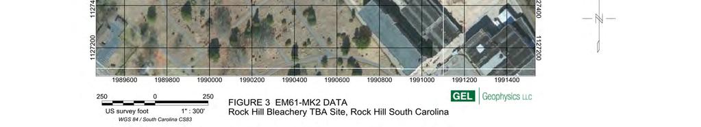
11 Geophysical Survey Rock Hill Bleachery TBA Site October 12, 2012 Rock Hill, South Carolina (tetr00312) Page 6 areas was so high it would likely not have been possible determining size and location of individual targets using CMD-4. The CMD-4 has a larger signal footprint than the EM61-MK2 and is more sensitive to signal saturation from multiple targets in the vicinity of the instrument. In order to derive the most detailed image possible of subsurface features, EM61-MK2 data was collected in the areas mentioned above using a profile spacing of 3 feet. Targets identified in CMD data outside of the EM61-MK2 grids were located in the field and inspected using GPR and EM61-MK2. GPR signal penetration was found to be very poor at areas outside of the concrete covered areas due to highly conductive and wet soils. On average the signal penetration in those areas was no more than 2 feet. GEL Geophysics and Tetra Tech therefore decided not to collect GPR data on a grid across the site and focus the efforts on EM surveys instead. GPR signal penetration on concrete covered areas was approximately 3-4 feet. GPR data was collected in bi-directional grids across the concrete surfaces using a nominal profile spacing of 5 feet. The GPR data was analyzed through a combination of real-time data analysis by the operator and grid analysis in the office. All detected subsurface features across the site, grid corners and other features of interest were spatially positioned using GPS. Note that surface features were recorded for the sole purpose of facilitating the geophysical investigation and should not be considered geodetically surveyed. 4.0 DATA INTERPRETATION AND RESULTS The processed CMD-4 data is shown on Figure 1 (conductivity data) and Figure 2 (in-phase data). The CMD-4 data was compared with the locations of surface metal and anomalies caused by surface metal were disregarded. Based on this data set, areas were selected for more detailed investigation. EM61-MK2 data was collected across areas with a high anomaly density (Figure 3). GPR data was collected over concrete surfaces since EM methods cannot detect features below reinforced concrete. The data sets were
12 Geophysical Survey Rock Hill Bleachery TBA Site October 12, 2012 Rock Hill, South Carolina (tetr00312) Page 7 analyzed for subsurface pipes and cables, potential USTs, vaults and other larger obstacles, as well as for smaller objects containing metal. Using the geophysical tools described, GEL Geophysics identified a large number of potential underground utilities, 30 unknown objects that could potentially be USTs, concrete vaults, or larger concrete slabs, and approximately 300 smaller objects containing metal. The smaller objects are likely larger chunks of debris from the razed buildings or chunks of reinforced concrete. The smaller objects vary in size but are believed to not be larger than approximately 4x4 feet and not more than 3 feet deep. In some areas, the density of subsurface metal was too high to identify individual targets. These areas and all features mentioned above are shown on Figures 4-7. An estimated 2,000 additional smaller and possibly deeper metallic objects also exists throughout the site (not marked on Figures 4-7). The data on the figures is presented in South Carolina State Plane, US Survey feet, NAD 83 coordinate system. There is a possibility that other subsurface features may exist at the project site that are not detectable by the geophysical systems due to either subsurface soil conditions or the occurrence of features below the signal penetration depth. To confirm the existence, exact location and dimensions of features, GEL Geophysics suggests they be probed for verification.
13
14


15
16
17
18
19
Report. Mearns Consulting LLC. Former Gas Station 237 E. Las Tunas Drive San Gabriel, California Project # E
 Mearns Consulting LLC Report Former Gas Station 237 E. Las Tunas Drive San Gabriel, California Project #1705261E Charles Carter California Professional Geophysicist 20434 Corisco Street Chatsworth, CA
The use of high frequency transducers, MHz, allowing the resolution to target a few cm thick in the first half meter suspect.
 METHODOLOGY GPR (GROUND PROBING RADAR). In recent years the methodology GPR (Ground Probing Radar) has been applied with increasing success under the NDT thanks to the high speed and resolving power. As
GPR SURVEY METHOD. Ground probing radar
 The ground penetrating radar (GPR - Ground Probing Radar) is a geophysical method used to investigate the near surface underground. Thanks to its high degree of resolution, the GPR is the most effective
Appendix I Geophysical Survey
 DRAFT IRM PRE- DESIGN INVESTIGATION DATA SUMMARY REPORT NATIONAL GRID FULTON MUNICIPAL WORKS FORMER MGP SITE APRIL 2013 Appendix I Geophysical Survey GEOPHYSICAL SURVEY FULTON MUNICIPAL WORKS FORMER MGP
Advanced Utility Locating Technologies (R01B)
") Advanced Utility Locating Technologies (R01B) Jacob Sheehan Senior Geophysicist Olson Engineering Phil Sirles Principal Geophysicist Olson Engineering Introduction: Utility Bundle Overview SHRP2 Strategic
Advanced Utility Locating Technologies (R01B) Jacob Sheehan Senior Geophysicist Olson Engineering Phil Sirles Principal Geophysicist Olson Engineering Introduction: Utility Bundle Overview SHRP2 Strategic
7. Consider the following common offset gather collected with GPR.
 Questions: GPR 1. Which of the following statements is incorrect when considering skin depth in GPR a. Skin depth is the distance at which the signal amplitude has decreased by a factor of 1/e b. Skin
A Report on the Ground Penetrating Radar Survey 205 Little Plains Road Southampton, NY
 A Report on the Ground Penetrating Radar Survey 205 Little Plains Road Southampton, NY November 18, 2016 Conducted by Robert W. Perry TOPOGRAPHIX, LLC Hudson, NH Requested by Southampton Town Historical
Archaeo-Geophysical Associates, LLC
 Geophysical Survey at the Parker Cemetery Rockwall, Texas. AGA Report 2010-6 Report Submitted To: Texas Cemetery Restoration 10122 Cherry Tree Dr. Dallas, Texas 75243 May 14, 2010 Chester P. Walker, Ph.D.
November 13, Hindu Temple, LTD Arbor Street Omaha, Nebraska Attn: Subject:
 November 13, 2017 Hindu Temple, LTD 13010 Arbor Street Omaha, Nebraska 68144-0000 Attn: Subject: Srini Mallipudi / mallipudis@gmail.com Underground Utility Survey Report Hindu Temple - 13010 Arbor Street,
Electromagnetic Induction
 Electromagnetic Induction Recap the motivation for using geophysics We have problems to solve Slide 1 Finding resources Hydrocarbons Minerals Ground Water Geothermal Energy SEG Distinguished Lecture slide
SURVEYING THE UNDERGROUND
 SURVEYING THE UNDERGROUND An Introduction to ASCE 38-02 and the Practice of Subsurface Utility Engineering ACECMD March 28, 2018 Presented by: Art Worthman A. Morton Thomas & Associates, Inc. John Berrettini
GPR Investigation: Post Tension Cable Mapping
 CMD Civil Pty Ltd PO Box 1119 Huntingdale VIC 3166 +61 3 9544 8833 info@cmdcivil.com www.cmdcivil.com Case Study: GPR Investigation: Post Tension Cable Mapping This application note demonstrates an example
Ground Penetrating Radar (GPR) By Dr. Eng. Zubair Ahmed
 By Dr. Eng. Zubair Ahmed") Ground Penetrating Radar (GPR) By Dr. Eng. Zubair Ahmed Acknowledgement Golder Associates, Whitby, Ontario Stantec Consulting, Kitchener, Ontario Infrasense Inc. USA Geophysical Survey Systems Inc. (GSSI),
Ground Penetrating Radar (GPR) By Dr. Eng. Zubair Ahmed Acknowledgement Golder Associates, Whitby, Ontario Stantec Consulting, Kitchener, Ontario Infrasense Inc. USA Geophysical Survey Systems Inc. (GSSI),
Advanced Ground Investigation Techniques to Help Limit Risk or Examine Failure. Advanced Subsurface Investigations
 Advanced Ground Investigation Techniques to Help Limit Risk or Examine Failure Overview Introduction What is geophysics? Why use it? Common Methods Seismic Ground Radar Electrical Case Studies Conclusion
Results of GPR survey of AGH University of Science and Technology test site (Cracow neighborhood).
.") Results of GPR survey of AGH University of Science and Technology test site (Cracow neighborhood). October 02, 2017 Two GPR sets were used for the survey. First GPR set: low-frequency GPR Loza-N [1]. Technical
Results of GPR survey of AGH University of Science and Technology test site (Cracow neighborhood). October 02, 2017 Two GPR sets were used for the survey. First GPR set: low-frequency GPR Loza-N [1]. Technical
Technical Note TN-30 WHY DOESN'T GEONICS LIMITED BUILD A MULTI-FREQUENCY EM31 OR EM38? J.D. McNeill
 Tel: (905) 670-9580 Fax: (905) 670-9204 GEONICS LIMITED E-mail:geonics@geonics.com 1745 Meyerside Dr. Unit 8 Mississauaga, Ontario Canada L5T 1C6 URL:http://www.geonics.com Technical Note TN-30 WHY DOESN'T
SIMULATION OF GPR SCENARIOS USING FDTD
 SIMULATION OF GPR SCENARIOS USING FDTD 1 GAMIL ALSHARAHI, 2 ABDELLAH DRIOUACH, 3 AHMED FAIZE 1,2 Department of physic, Abdelmalek Essaâdi University, Faculty of sciences, Morocco 3 Department of physic,
Statement of Qualifications
 Revised January 29, 2011 ClearView Geophysics Inc. 12 Twisted Oak Street Brampton, ON L6R 1T1 Canada Phone: (905) 458-1883 Fax: (905) 792-1884 general@geophysics.ca www.geophysics.ca 1 1. Introduction
STANDARD OPERATING PROCEDURES SOP:: 2057 PAGE: 1 of 6 REV: 0.0 DATE: 07/11/03
 PAGE: 1 of 6 1.0 SCOPE AND APPLICATION 2.0 METHOD SUMMARY CONTENTS 3.0 SAMPLE PRESERVATION, CONTAINERS, HANDLING, AND STORAGE 4.0 INTERFERENCES AND POTENTIAL PROBLEMS 5.0 EQUIPMENT/APPARATUS 6.0 REAGENTS
An acousto-electromagnetic sensor for locating land mines
 An acousto-electromagnetic sensor for locating land mines Waymond R. Scott, Jr. a, Chistoph Schroeder a and James S. Martin b a School of Electrical and Computer Engineering b School of Mechanical Engineering
ARCHAEOLOGICAL GEOPHYSICS: SENSOR SELECTION AND SITE SUITABILITY
 ARCHAEOLOGICAL GEOPHYSICS: SENSOR SELECTION AND SITE SUITABILITY A SPARC Webinar presented on October 17, 2014 Eileen G. Ernenwein, PhD ETSU: http://faculty.etsu.edu/ernenwei/ CAST: http://goo.gl/wyzlp
Old & New? INTRODUCTION. The Best Proximal Geophysical Detector Ever!
 Measuring Soil Conductivity with Geonics Limited Electromagnetic Geophysical Instrumentation INTRODUCTION This presentation will briefly discuss the principles of operation and the practical applications
THE BEST GPR DATA QUALITY AT THE BEST PRICE! GROUND PENETRATING RADAR ZOND-12e G R O U N D P E N E T R A T I N G R A D A R S
 GROUND PENETRATING RADAR ZOND-12e General Purpose Pulse GPR ZOND-12e SINGLE CHANNEL OR ADVANCED CONTROL UNITS ZOND 12e GPR is a portable digital Ground Penetrating Radar carried by a single operator. The
HELICOPTER-BORNE GEOPHYSICAL SURVEY SYSTEMS
 HELICOPTER-BORNE GEOPHYSICAL SURVEY SYSTEMS APPLICATIONS: base & precious metals exploration diamondiferous kimberlite exploration geological mapping mapping of fault zones for engineering and mining applications
GROUND PENETRATING RADAR (GEORADAR) INSPECTION
 INSPECTION") - CIVIL ENGENEERING - GEOLOGY AND ENVIRONMENT - GROUND PENETRATING RADAR - LOSSES DETECTING RADAR SYSTEM - ARCHEOLOGY & CULTURAL HERITAGE - CARGO INSPECTION - LOSS CONTROL - CHEMICAL ANALYSIS - INDUSTRIAL
- CIVIL ENGENEERING - GEOLOGY AND ENVIRONMENT - GROUND PENETRATING RADAR - LOSSES DETECTING RADAR SYSTEM - ARCHEOLOGY & CULTURAL HERITAGE - CARGO INSPECTION - LOSS CONTROL - CHEMICAL ANALYSIS - INDUSTRIAL
GPR Data Acquisition and Interpretation
 1 GPR Data Acquisition and Interpretation Mezgeen Rasol PhD Candidate Geophysics and Seismic Engineering Polytechnic University of Catalonia mezgeen.rasol@upc.edu BIG-SKY-EARTH Cost Action TD143 Workshop
In search of a Historic Grave: GPR Investigation near the Yellowstone Lake Store: 7/15/2010
 In search of a Historic Grave: GPR Investigation near the Yellowstone Lake Store: 7/15/2010 Steven Sheriff Professor of Geophysics Department of Geosciences University of Montana Missoula, Montana Introduction
Geology 228/378 Environmental Geophysics Lecture 10. Electromagnetic Methods (EM) I And frequency EM (FEM)
 I And frequency EM (FEM)") Geology 228/378 Environmental Geophysics Lecture 10 Electromagnetic Methods (EM) I And frequency EM (FEM) Lecture Outline Introduction Principles Systems and Methods Case Histories Introduction Many EM
Geology 228/378 Environmental Geophysics Lecture 10 Electromagnetic Methods (EM) I And frequency EM (FEM) Lecture Outline Introduction Principles Systems and Methods Case Histories Introduction Many EM
PS 1000 X-Scan Tips & Tricks. Quick Guide
 PS 1000 X-Scan Tips & Tricks Quick Guide en en QUICK GUIDE Tips & tricks 1. PS 1000 X-Scan Scanning on rough surfaces When the scanner is moved over a rough surface, the distance between the scanner and
SURVEYING THE UNDERGROUND
 SURVEYING THE UNDERGROUND An Introduction to the Practice of Subsurface Utility Engineering Maryland Society of Surveyors Maryland Society of Professional Engineers Joint Conference October 8, 2015 Michael
Detection of Pipelines using Sub-Audio Magnetics (SAM)
") Gap Geophysics Australia Pty Ltd. Detection of Pipelines using Sub-Audio Magnetics is a patented technique developed by Gap Geophysics. The technique uses a fast sampling magnetometer to monitor magnetic
Gap Geophysics Australia Pty Ltd. Detection of Pipelines using Sub-Audio Magnetics is a patented technique developed by Gap Geophysics. The technique uses a fast sampling magnetometer to monitor magnetic
HAZARDS OF ELECTROMAGNETIC RADIATION TO ORDNANCE (HERO) CONCERNS DURING UXO LOCATION/REMEDIATION
 CONCERNS DURING UXO LOCATION/REMEDIATION") HAZARDS OF ELECTROMAGNETIC RADIATION TO ORDNANCE (HERO) CONCERNS DURING UXO LOCATION/REMEDIATION Kurt E. Mikoleit Naval Surface Warfare Center, Dahlgren Division Dahlgren, Virginia ABSTRACT: As part of
HAZARDS OF ELECTROMAGNETIC RADIATION TO ORDNANCE (HERO) CONCERNS DURING UXO LOCATION/REMEDIATION Kurt E. Mikoleit Naval Surface Warfare Center, Dahlgren Division Dahlgren, Virginia ABSTRACT: As part of
Tri-band ground penetrating radar for subsurface structural condition assessments and utility mapping
 Tri-band ground penetrating radar for subsurface structural condition assessments and utility mapping D. Huston *1, T. Xia 1, Y. Zhang 1, T. Fan 1, J. Razinger 1, D. Burns 1 1 University of Vermont, Burlington,
Case Studies and Innovative Uses of GPR for Pavement Engineering Applications
 Case Studies and Innovative Uses of GPR for Pavement Engineering Applications Richard Korczak, MASc., P.Eng., Stantec Consulting Ltd. Amir Abd El Halim, PhD., P.Eng., Stantec Consulting Ltd. Paper prepared
Exploration Beyond Expectation. Geo-Carte Radar Technology Pvt. Ltd.
 Exploration Beyond Expectation Geo-Carte Radar Technology Pvt. Ltd. Problem Unknown distribution network of underground pipeline in India 32% Damage of pre-existing underground utilities during laying
Pitfalls in GPR Data Interpretation: Differentiating Stratigraphy and Buried Objects from Periodic Antenna and Target Effects
 GEOPHYSICAL RESEARCH LETTERS, VOL. 27, NO. 20, PAGES 3393-3396, OCTOBER 15, 2000 Pitfalls in GPR Data Interpretation: Differentiating Stratigraphy and Buried Objects from Periodic Antenna and Target Effects
MARINE GEOPHYSICAL PROVE-OUT AND SURVEY AT FLAG LAKE BOMBING RANGE BARKSDALE AIR FORCE BASE, LOUISIANA
 MARINE GEOPHYSICAL PROVE-OUT AND SURVEY AT FLAG LAKE BOMBING RANGE BARKSDALE AIR FORCE BASE, LOUISIANA Garrick Marcoux 1, Wallace Robertson 2, Boban Stojanovic 1, Jeffrey B. Hackworth 1 1 FPM Geophysical
Here the goal is to find the location of the ore body, and then evaluate its size and depth.
 Geophysics 223 March 2009 D3 : Ground EM surveys over 2-D resistivity models D3.1 Tilt angle measurements In D2 we discussed approaches for mapping terrain conductivity. This is appropriate for many hydrogeology
Ground Penetrating Radar
 Ground Penetrating Radar Begin a new section: Electromagnetics First EM survey: GPR (Ground Penetrating Radar) Physical Property: Dielectric constant Electrical Permittivity EOSC 350 06 Slide Di-electric
Radiodetection. Fundamental principles and techniques in buried utility location
 Fundamental principles and techniques in buried utility location Canada 344 Edgeley Blvd. Unit 34 Concord, Ontario L4K 4B7 1-800-665-7953 Pipe and Cable Locators don't find pipes and cables...? 2 ...they
Ground Penetrating Radar (day 1) EOSC Slide 1
 EOSC Slide 1") Ground Penetrating Radar (day 1) Slide 1 Introduction to GPR Today s Topics Setup: Motivational Problems Physical Properties - Dielectric Permittivity and Radiowaves - Microwave Example Basic Principles:
Ground Penetrating Radar (day 1) Slide 1 Introduction to GPR Today s Topics Setup: Motivational Problems Physical Properties - Dielectric Permittivity and Radiowaves - Microwave Example Basic Principles:
P Forsmark site investigation. RAMAC and BIPS logging in borehole HFM11 and HFM12
 P-04-39 Forsmark site investigation RAMAC and BIPS logging in borehole HFM11 and HFM12 Jaana Gustafsson, Christer Gustafsson Malå Geoscience AB/RAYCON March 2004 Svensk Kärnbränslehantering AB Swedish
Lockheed Martin Corporation 6801 Rockledge Drive MP: CCT-246 Bethesda, MD Telephone
 Lockheed Martin Corporation 6801 Rockledge Drive MP: CCT-246 Bethesda, MD 20817 Telephone 301-548-2209 August 5, 2015 VIA PRIVATE CARRIER Mr. James R. Carroll Program Administrator Land Restoration Program
Increasing the Probability of Detection and Evaluation of Buried Metallic Objects by Data Fusion GPR- Low Frequency Electromagnetic Sensor Array
 4th European-American Workshop on Reliability of NDE - Poster 4 Increasing the Probability of Detection and Evaluation of Buried Metallic Objects by Data Fusion GPR- Low Frequency Electromagnetic Sensor
Lessons Learned in Conducting Acoustic Leak Detection Surveys on Water Distribution Systems at 12 Military Installations
 Lessons Learned in Conducting Acoustic Leak Detection Surveys on Water Distribution Systems at 12 Military Installations Harmon Henderson, PE Perry Gayle, PhD, PE, LEED AP 14 April 2015 Presentation Overview
Applied Geophysics Nov 2 and 4
 Applied Geophysics Nov 2 and 4 Effects of conductivity Surveying geometries Noise in GPR data Summary notes with essential equations Some Case histories EOSC 350 06 Slide 1 GPR Ground Penetrating Radar
Investigation of Bridge Decks Utilizing Ground Penetrating Radar
 Investigation of Bridge Decks Utilizing Ground Penetrating Radar Steve Cardimona *, Brent Willeford *, John Wenzlick +, Neil Anderson * * The University of Missouri-Rolla, Department of Geology and Geophysics
Dynatel 2250E/2273E Advanced Cable and Fault Locator
 Dynatel 2250E/2273E Advanced Cable and Fault Locator Operators Manual September 1999 78-8097-6500-7-B TABLE OF CONTENTS Introduction... 2 Installing or Replacing the Batteries... 2 Initial Receiver Configuration...
FINAL GEOPHYSICAL SURVEY REPORT CATLIN CEMETERY AND HISTORIC TRAILS PEABODY, KANSAS
 FINAL GEOPHYSICAL SURVEY REPORT CATLIN CEMETERY AND HISTORIC TRAILS PEABODY, KANSAS MARCH 2010 Prepared by: FPM Geophysical & UXO Services 5559 NW Barry Rd. #251 Kansas City, Missouri 64154 March 29, 2010
Utility Locating Terminology & Equipment Guide. Utility Survey Corp.
 Utility Locating Terminology & Equipment Guide Utility Survey Corp. Contents Utility Locating Terminology Utility Locating Toning or Scoping Scanning X Ray the Ground & Ground Penetrating Radar 3 4 5 6
IEEE Electromagnetic Compatibility Standards (Active & Archive) Collection: VuSpec
 Collection: VuSpec") IEEE Electromagnetic Compatibility Standards (Active & Archive) Collection: VuSpec This value-packed VuSpec represents the most complete resource available for professional engineers looking for best practices
IEEE Electromagnetic Compatibility Standards (Active & Archive) Collection: VuSpec This value-packed VuSpec represents the most complete resource available for professional engineers looking for best practices
Using ground penetrating radar to quantify changes in the fracture pattern associated with a simulated rockburst experiment
 Using ground penetrating radar to quantify changes in the fracture pattern associated with a simulated rockburst experiment by M. Grodner* Synopsis Ground Penetrating Radar (GPR) is an electromagnetic
Radar Methods General Overview
 Environmental and Exploration Geophysics II Radar Methods General Overview tom.h.wilson tom.wilson@mail.wvu.edu Department of Geology and Geography West Virginia University Morgantown, WV Brown (2004)
3D UTILITY MAPPING USING ELECTRONICALLY SCANNED ANTENNA ARRAY. Egil S. Eide and Jens F. Hjelmstad
 D UTILITY MAPPING USING ELECTRONICALLY SCANNED ANTENNA ARRAY Egil S. Eide and Jens F. Hjelmstad Department of Telecommunications Norwegian University of Science and Technology, N-79 Trondheim, Norway eide@tele.ntnu.no
APPENDIX E INSTRUMENT VERIFICATION STRIP REPORT. Final Remedial Investigation Report for the Former Camp Croft Spartanburg, South Carolina Appendices
 Final Remedial Investigation Report for the Former Camp Croft APPENDIX E INSTRUMENT VERIFICATION STRIP REPORT Contract No.: W912DY-10-D-0028 Page E-1 Task Order No.: 0005 Final Remedial Investigation Report
Geophysical Classification for Munitions Response
 Geophysical Classification for Munitions Response Technical Fact Sheet June 2013 The Interstate Technology and Regulatory Council (ITRC) Geophysical Classification for Munitions Response Team developed
CSAMT Geophysical Survey K2 Groundwater Project
 CSAMT Geophysical Survey K2 Groundwater Project Strawberry, Arizona Prepared for: Pine Water Company January 30, 2008 by Zonge Engineering & Research Organization, Inc. 3322 E Fort Lowell Rd. Tucson, Arizona,
GPR Part II: Effects of conductivity. Surveying geometries. Noise in GPR data. Summary notes with essential equations. Some Case histories
 GPR Part II: Effects of conductivity Surveying geometries Noise in GPR data Summary notes with essential equations Some Case histories EOSC 350 06 Slide 1 GPR Ground Penetrating Radar R = ε ε 2 2 + ε ε
Assessment of layer thickness and uniformity in railway embankments with Ground Penetrating Radar
 Assessment of layer thickness and uniformity in railway embankments with Ground Penetrating Radar F.M. Fernandes Department of Civil Engineering, University of Minho, Guimarães, Portugal M. Pereira Geotechnique
3. Electromagnetic methods 3.1 Introduction
 3. Electromagnetic methods 3.1 Introduction The electromagnetic techniques have the broadest range of different instrumental systems. They can be classified as either time domain (TEM) of frequency domain
UTILITY LOCATING EQUIPMENT
 RIDGID SEEKTECH LOCATING RECEIVERS RIDGID locating receivers feature an easy-to-use visual mapping display that allows you to locate utility lines and sondes/beacons with confidence. Use with a SeeSnake
Application of Ground Penetrating Radar for River Ice Surveys
 CGU HS Committee on River Ice Processes and the Environment 14th Workshop on the Hydraulics of Ice Covered Rivers Quebec City, June 19-22, 2007 Application of Ground Penetrating Radar for River Ice Surveys
Covert Tunnel Detection Technologies
 2015 Covert Tunnel Detection Technologies Homeland Security Research Corp. Covert Tunnel Detection Technologies 2015 August 2015 Homeland Security Research Corp. (HSRC) is an international market and technology
INDEX PREFACE... 1 CAUTIONS... 2 OPERATION ON SITE(9) STANDARD INSTRUMENT... 3 OPTIONAL ACCESSORIES... 4 OPERATION OF TRANSMITTER(3)...
 STANDARD INSTRUMENT... 3 OPTIONAL ACCESSORIES... 4 OPERATION OF TRANSMITTER(3)...") INDEX PREFACE... 1 CAUTIONS... 2 STANDARD INSTRUMENT... 3 OPTIONAL ACCESSORIES... 4 OPERATION OF TRANSMITTER(1)... 5 (Transmitter Unit.) OPERATION OF TRANSMITTER(2)... 6 (Operation Panel, LCD Display of
INDEX PREFACE... 1 CAUTIONS... 2 STANDARD INSTRUMENT... 3 OPTIONAL ACCESSORIES... 4 OPERATION OF TRANSMITTER(1)... 5 (Transmitter Unit.) OPERATION OF TRANSMITTER(2)... 6 (Operation Panel, LCD Display of
VALIDATION OF GROUND PENETRATING RADAR DATA INTERPRETATION USING AN ELECTROMAGNETIC WAVE PROPAGATION SIMULATOR
 Romanian Reports in Physics, Vol. 68, No. 4, P. 1584 1588, 2016 VALIDATION OF GROUND PENETRATING RADAR DATA INTERPRETATION USING AN ELECTROMAGNETIC WAVE PROPAGATION SIMULATOR A. CHELMUS National Institute
Abstract. Introduction
 TARGET PRIORITIZATION IN TEM SURVEYS FOR SUB-SURFACE UXO INVESTIGATIONS USING RESPONSE AMPLITUDE, DECAY CURVE SLOPE, SIGNAL TO NOISE RATIO, AND SPATIAL MATCH FILTERING Darrell B. Hall, Earth Tech, Inc.,
Experiment on Artificial Frozen Soil Boundary GPR Detection During Cross-passage Construction in Tunnels
 354 Progress In Electromagnetics Research Symposium 2005, Hangzhou, China, August 22-26 Experiment on Artificial Frozen Soil Boundary GPR Detection During Cross-passage Construction in Tunnels Yong-Hui
PULSE MATIC 9000 FULL DIGITAL New professional metal detector
 1 PULSE MATIC 9000 FULL DIGITAL New professional metal detector IMPORTANT NOTE: The battery charger of your PULSE MATIC is 110v-240v at 12v. Consequently this battery charger can be plugged in any (AC)
Electronic Pipeline Technology
 Pipe and Cable Locator Pearson Holiday Detector Model EPT- 1000 Electronic Pipeline Technology Electronic Pipeline Technology 26 Palomino Drive, Richmond Hill, Ontario, Canada, L4C 0P8 Tel: (905) 918-0025
Telephone Cable Locating Techniques
 Chapter 2 Telephone Cable Locating Techniques Introduction Read Chapter One of this manual to learn more general information about each of the following signal application methods. The following paragraphs
Trees, vegetation, buildings etc.
 EMC Measurements Test Site Locations Open Area (Field) Test Site Obstruction Free Trees, vegetation, buildings etc. Chamber or Screened Room Smaller Equipments Attenuate external fields (about 100dB) External
HGD HURRICANE 2010 / 2011
 HGD HURRICANE 2010 / 2011 The Global Surprise For the Treasures Hunters, Prospecting Amateurs, for all Researchers for Gold and Underground Metals Introduction: The Modern scientific Innovation, Exclusive
Resolutionof Ground-penetrating Radar Reflections at Differing Frequencies
 Archaeological Prospection Archaeol. Prospect. 13, 141 145 (2006) Published online in Wiley InterScience (www.interscience.wiley.com). DOI: 10.1002/arp.283 Resolutionof Ground-penetrating Radar Reflections
BURIED LANDFILL DELINEATION WITH INDUCED POLARIZATION: PROGRESS AND PROBLEMS* Abstract. Introduction
 BURIED LANDFILL DELINEATION WITH INDUCED POLARIZATION: PROGRESS AND PROBLEMS* Norman R. Carlson, Jennifer L. Hare, and Kenneth L. Zonge Zonge Engineering & Research Organization, Inc., Tucson, AZ *In Proceedings
SIR, UtilityScan and RADAN are registered trademarks of Geophysical Survey Systems, Inc.
 Copyright 2016-2017 Geophysical Survey Systems, Inc. All rights reserved including the right of reproduction in whole or in part in any form Published by Geophysical Survey Systems, Inc. 40 Simon Street
Experimental investigation of the acousto-electromagnetic sensor for locating land mines
 Proceedings of SPIE, Vol. 3710, April 1999 Experimental investigation of the acousto-electromagnetic sensor for locating land mines Waymond R. Scott, Jr. a and James S. Martin b a School of Electrical
Overview of EMC Regulations and Testing. Prof. Tzong-Lin Wu Department of Electrical Engineering National Taiwan University
 Overview of EMC Regulations and Testing Prof. Tzong-Lin Wu Department of Electrical Engineering National Taiwan University What is EMC Electro-Magnetic Compatibility ( 電磁相容 ) EMC EMI (Interference) Conducted
AC Voltage- Pipeline Safety and Corrosion MEA 2015
 AC Voltage- Pipeline Safety and Corrosion MEA 2015 WHAT ARE THE CONCERNS ASSOCIATED WITH AC VOLTAGES ON PIPELINES? AC concerns Induced AC Faults Lightning Capacitive coupling Safety Code Induced AC Corrosion
Understanding Seismic Amplitudes
 Understanding Seismic Amplitudes The changing amplitude values that define the seismic trace are typically explained using the convolutional model. This model states that trace amplitudes have three controlling
European Scientific Journal February 2014 /SPECIAL/ edition vol.3 ISSN: (Print) e - ISSN
 e - ISSN") HIGH PRECISION CALCULATION OF MOVE OUT CORRECTION IN GPR MEASUREMENTS Janis Karuss, M.Sc. University of Latvia, Latvia Abstract Ground penetrating radar (GPR) is a non-invasive geophysical method that
HIGH PRECISION CALCULATION OF MOVE OUT CORRECTION IN GPR MEASUREMENTS Janis Karuss, M.Sc. University of Latvia, Latvia Abstract Ground penetrating radar (GPR) is a non-invasive geophysical method that
High Voltage Pylon earth Measurements. Tycom (Pty) Ltd Frank Barnes Comtest (Pty) Ltd Presented by Gavin van Rooy
 Ltd Frank Barnes Comtest (Pty) Ltd Presented by Gavin van Rooy") High Voltage Pylon earth Measurements Tycom (Pty) Ltd Frank Barnes Comtest (Pty) Ltd Presented by Gavin van Rooy Abstract The earth connection of high voltage electrical power line pylons is obviously
High Voltage Pylon earth Measurements Tycom (Pty) Ltd Frank Barnes Comtest (Pty) Ltd Presented by Gavin van Rooy Abstract The earth connection of high voltage electrical power line pylons is obviously
Experience of GPR application in oil-and-gas industry
 Experience of GPR application in oil-and-gas industry V. V. Kopeikin, P. A. Morozov, F. D. Edemskiy and D. E. Edemskiy Department of radio wave propagation Pushkov Institute of Terrestrial Magnetism, Ionosphere
Using GPR Technique Assessment for Study the Sub-Grade of Asphalt and Concrete Conditions
 Using GPR Technique Assessment for Study the Sub-Grade of Asphalt and Concrete Conditions Alaa S. Mahdi Remote Sensing Unit, College of Science, University of Baghdad, Baghdad, Iraq Abstract The Ground
ELECTROMAGNETIC FIELD APPLICATION TO UNDERGROUND POWER CABLE DETECTION
 ELECTROMAGNETIC FIELD APPLICATION TO UNDERGROUND POWER CABLE DETECTION P Wang *, K Goddard, P Lewin and S Swingler University of Southampton, Southampton, SO7 BJ, UK *Email: pw@ecs.soton.ac.uk Abstract:
Identification of Pipelines from the Secondary Reflect Wave Travel Time of Ground-Penetrating Radar Waves
 Journal of Emerging Trends in Engineering and Applied Sciences (JETEAS) 2 (5): 770-774 Scholarlink Research Institute Journals, 2011 (ISSN: 2141-7016) jeteas.scholarlinkresearch.org Journal of Emerging
Opera Duo. GeoRadar Division
 Utilities Detection and Mapping Opera Duo: real-time detection of pipes RIS MF Hi-Mod: Utilities mapping on all zones All rights reserved to IDS 2 Utilities Detection and Mapping Stream: massive arrays
SUBSURFACE MAPPING. Presenters: Thomas Kevin Hanna, PLS. Paul J. Emilius Jr., PLS CP
 SUBSURFACE MAPPING Presenters: Thomas Kevin Hanna, PLS Paul J. Emilius Jr., PLS CP February 2 nd 2011 1 Existing Underground Utilities Abound! Power, Telecommunications, Gas/Propane, Petroleum, Sanitary
 Page 1 of 10 SENSOR EVALUATION STUDY FOR USE WITH TOWED ARRAYS FOR UXO SITE CHARACTERIZATION J.R. McDonald Chemistry Division, Code 6110, Naval Research Laboratory Washington, DC 20375, 202-767-3556 Richard
Sferic signals for lightning sourced electromagnetic surveys
 Sferic signals for lightning sourced electromagnetic surveys Lachlan Hennessy* RMIT University hennessylachlan@gmail.com James Macnae RMIT University *presenting author SUMMARY Lightning strikes generate
3 Dynatel M Series Locating and Marking System DOCUMENT NEW- TO- THE- WORLD TECHNOLOGY OBSOLETE DAMAGE PREVENTION PIN- POINT ACCURACY SAFETY
 3 Dynatel M Series Locating and Marking System NEW- TO- THE- WORLD TECHNOLOGY PIN- POINT ACCURACY SAFETY DAMAGE PREVENTION Introducing the 3M Dynatel M-iD Series Locating and Marking System. NEW TECHNOLOGY
L O C A T O R G P R. Introducing the. Radarteam. Ground Probing Radar/Antenna system with Rugged PC and Cart ü
 Introducing the L O C A T O R G P R Ground Probing Radar/Antenna system with Rugged PC and Cart ü Fully integrated system. Multi Frequency operation: 100-900 MHz ü Air/Ground Coupled operation. Multiple
EKKO_Project is the all-inclusive software SUBSURFACE VIEWS. EKKO_Project V4 Released. In this issue GPR INNOVATIONS HARDWARE AND SOFTWARE
 SUBSURFACE VIEWS GPR INNOVATIONS HARDWARE AND SOFTWARE In this issue 1, 2, 3 EKKO_Project V4 Released 3, 4 EAGE 2015 Boot Camp 5, 6 TIPS: Using the Water Table to Add Topography January, 2016 - Vol. 12,
HANDS ON EXPERIENCE WITH THE BROADBAND ELECTROMAGNETIC TOOL IN THE TRENCH
 The Northern California Pipe User s Group 22nd Annual Sharing Technologies Seminar www.norcalpug.com Berkeley, CA February 20, 2014 HANDS ON EXPERIENCE WITH THE BROADBAND ELECTROMAGNETIC TOOL IN THE TRENCH
RD1000 Ground Probing Radar
 RD1000 Ground Probing Radar CONTENTS Product Introduction Product Features Competitor Analysis Customers Models, Pricing & Availability Promotional Material Practical Demonstration What to do now Summary
ALIS. Project Identification Project name Acronym
 ALIS Project Identification Project name ALIS Acronym Advanced Landmine Imaging System Participation Level National (Japanese) Financed by JST(Japan Science and Technology Agency) Budget N/A Project Type
Electromagnetic Compatibility
 Electromagnetic Compatibility Introduction to EMC International Standards Measurement Setups Emissions Applications for Switch-Mode Power Supplies Filters 1 What is EMC? A system is electromagnetic compatible
A NOVEL APPROACH TO NON-PIGGABLE SUBSEA PIPELINE INSPECTION
 A NOVEL APPROACH TO NON-PIGGABLE SUBSEA PIPELINE INSPECTION S. Hartmann, Innospection Ltd., Aberdeen Dr. K. Reber, Innospection Germany GmbH, Stutensee, Germany A. Boenisch, Innospection Ltd., Aberdeen
Accurate Utility Depth Measurements Using the Spar 300
 Accurate Utility Depth Measurements Using the Spar 3 This Application Note addresses how to obtain accurate subsurface utility depths using the model-based methods employed by the Spar 3. All electromagnetic
SeekTech SR-60 SeekTech SR-20 NaviTrack Scout
 Locating Equipment RIDGID Receivers RIDGID locating receivers feature an easy to use visual mapping display that allows you to locate utility lines and sondes/ beacons with confidence. Use with a SeeSnake
Dowel Alignment: Measurement and Impacts on Pavement Performance
 Dowel Alignment: Measurement and Impacts on Pavement Performance prepared by: Mark B. Snyder, Ph.D., P.E. Vice-President, ACPA-PA Chapter for: ACPA s 2012 Annual Meeting Concrete Pavement University November