Exploration Beyond Expectation. Geo-Carte Radar Technology Pvt. Ltd.
|
|
|
- Emmeline Doyle
- 5 years ago
- Views:
Transcription

1 Exploration Beyond Expectation Geo-Carte Radar Technology Pvt. Ltd.
2 Problem Unknown distribution network of underground pipeline in India 32% Damage of pre-existing underground utilities during laying of new ones Leakage in buried water and sewage pipelines leading to contamination Degradation of road network due to poor drainage condition Reduced efficiency of ballast cleaning machine due to buried unwanted scrap Unexplored locations for Archaeological excavations


3 Objective To introduce a non-destructive subsurface exploration method, which leads to Prevention Optimization Correct Layout Cost Effective Time Efficient Effective & Reliable

4 Introduction to GPR Non Destructive subsurface exploration technique Works on the principle of Electromagnetic waves Waves are reflected from the boundary of dielectric contrast Hyperbolic reflections across the target Depth of penetration ranges from few cm to m Waves are reflected from the boundary of Trade off between dielectric frequency contrast and resolution Ground Penetrating Radar (GPR) Weak signals in case of wet clayey soil

5 1.7 m Current Limitation antenna Investigated Site Expected Results Actual Results Obtained Fails to provide satisfactory result in case of weak signals Low dielectric contrast, wet clayey soil, conductive medium


6 1.7 m Our Developed Technology antenna Investigated Site Conventional Output Improved Output Advanced T-F analysis & better interpretation for weak signal data Enhanced Resolution of subsurface profile Satisfactory results even in high salt content & wet clayey soils


7 Benefits Prevent underground utility damage during trenching/tunnelling Map unrecorded network underground utility Leak detection in underground pipelines Roads inspection to avoid accidents due to poor construction practices Mapping underneath sinkholes leading to huge road accidents Locate under ballast obstructions leading to increased BCM efficiency Locate potential locations for excavation in archaeological sites
8 Competitive Edge Reliable and efficient Satisfactory results despite high salt content & wet clayey soils Enhanced image resolution over conventional methods Advanced analysis and better interpretation Effective data and reliable outputs in all site conditions Customised services and products for specific purpose


9 Applications Utility Mapping Road & Highway Inspection Concrete Structure Inspection To map water pipelines, sewage lines, gas pipelines, electrical cables, underground storage tanks To inspect the highway cross-section For bridge deck evaluation For railway ballast evaluation To locate voids and cracks in concrete structures For slab thickness measurement Archaeological Investigation For mapping archaeological features to plan the digging for exploration and preservation purpose Other Applications For landmine detection For ground water table mapping For mineral exploration


10 About Geo-Carte Government Organization Incubated at IIT Gandhinagar Our Esteemed Clients Construction Companies Utility Companies Transportation Infrastructure Agencies Archaeological Departments Clientele We Serve Defence Agencies


11 Feedback from Our Customers


12 Team and Advisors Silky Agrawal Founder & CEO John Samson Darpan Agrawal Advisors Incubated at Prof. Amit Prashant Professor, IIT Gandhinagar Prof. S. K. Jain Director, IIT Gandhinagar IIT Gandhinagar Incubation Centre
13 Reach info@geocarte.in Follow

14 GeoCarte s Few Success Stories
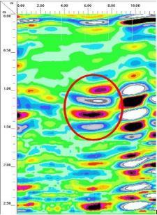
15 UTILITY MAPPING OVER CONCRETE SURFACE AT IIT VGEC CAMPUS
16 3 m 3-D Data Collection 3 m Data was collected over and around the manhole in an area of 3m X 3m in a grid Manhole Grid spacing of 0.5m Using 400 MHz antenna

17 Output Results Captured the clear features of pipes crossing at 0.5 m depth was after post-processing
18 UTILITY MAPPING AT DAHEJ

19 Why survey was required? Encountered unknown pipe during tunneling To avoid encounter of other such pipe in further execution To design new layout of the pipe preventing damage of pre-existing lines


20 Survey Specifics Total area scanned is around 33,00 m 2, 3 road crossings 3D data collection Antenna used 200 MHz Grid spacing varying from 2 to 3 m Maximum accessible area was covered in rectangular fashion
21 Data Collection


22 3D subsurface view


23 2D subsurface profiles
24 Output Result Site-1
25 UTILITY MAPPING AT DAHEJ SEZ 2


26 Why survey was required? To ensure a clear stretch of 30 m width along longitudinal direction To avoid encounter of other across pipes during installing new utility To design new layout of the pipe preventing damage of pre-existing lines


27 Details of Investigated Area Site Location- Dahej SEZ-2, Gujarat Surrounded by petro-chemical industries Challenging for data collection


28 2D subsurface profiles Total area scanned is around m 2 2D data collection Antenna used 200 MHz Data was collected along the accessible transects Detected 5 utilities along the road and 5 utilities across the road
29 Output Result
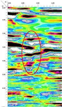
30 VOID DETECTION UNDER ROAD AT DAHEJ


31 Survey Specifics Total area scanned is around an Acre 3D data collection Antenna used 400 MHz to cover depth of 2.5 to 3m Grid spacing of 3 m Maximum accessible area was covered in rectangular fashion


32 2D & 3D subsurface view
33 RAILWAY BALLAST INVESTIGATION AT GANDHINAGAR AND CST MUMBAI
34 Purpose of the survey To explore the applicability of GPR for railway ballast investigation To map all the possible obstructions in ballast, e.g. cables, rail pieces, etc. To improve the efficiency of the Ballast Cleaning Machine (BCM)


35 Survey Specifics 3 Stretches of length 100m was considered for the survey Buried 9 targets at approximate depth of 0.2 to 0.3 m Customized cart was developed for smooth movement over the railway track Used 900 MHz antennae for less penetration with higher resolution Three profiles were collected to cover the width of the track Improved resolution of the targets with advanced analysis


36 Output Results 8 out of 9 buried targets could be located by conventional method 3 extra targets were located by advanced analysis method Total 12 targets were detected Resolution is enhanced by advanced analysis
37 ARCHAEOLOGICAL INVESTIGATION AT KADAPA


38 Details of Investigated Area Total area covered is around 1 Acre Expected area was covered in rectangular fashion Data was collected using 200 and 100 MHz antenna 3D data collection in grid at spacing of 3 m with dense grid at expected location


39 Output Results Observed 4 target locations and a linear feature representing wall kind reflections
40 ARCHAEOLOGICAL INVESTIGATION AT DHOLAVIRA

41 Details of Investigated Area Situated at Khadirbet in Bhachau Taluka of Kutch District, in the state of Gujarat. Total area covered is m 2 Maximum accessible area was covered in rectangular fashion Data was collected using 400 and 200 MHz antenna 3D Data collection in grid


42 Output Results Conventional Profile Improved Profile 3-D view at different depths


43 Output Results 3-D subsurface view of areas Depth slice at a particular depth Observed features are marked
44 Time Demand Average time requirement for the survey over either an area of 1 Acre or 5 km length of two lane road 1 Day Field survey (Data acquisition using GPR) 2 Days Conventional post-processing 2 Days Advanced analysis with TF method 3 Days Interpretation of observed features 2 Days Report preparation
45 Geo-Carte Thank You POWERPOINT 2010
GPR SURVEY METHOD. Ground probing radar
 The ground penetrating radar (GPR - Ground Probing Radar) is a geophysical method used to investigate the near surface underground. Thanks to its high degree of resolution, the GPR is the most effective
GPR Data Acquisition and Interpretation
 1 GPR Data Acquisition and Interpretation Mezgeen Rasol PhD Candidate Geophysics and Seismic Engineering Polytechnic University of Catalonia mezgeen.rasol@upc.edu BIG-SKY-EARTH Cost Action TD143 Workshop
Ground Penetrating Radar (GPR) By Dr. Eng. Zubair Ahmed
 By Dr. Eng. Zubair Ahmed") Ground Penetrating Radar (GPR) By Dr. Eng. Zubair Ahmed Acknowledgement Golder Associates, Whitby, Ontario Stantec Consulting, Kitchener, Ontario Infrasense Inc. USA Geophysical Survey Systems Inc. (GSSI),
Ground Penetrating Radar (GPR) By Dr. Eng. Zubair Ahmed Acknowledgement Golder Associates, Whitby, Ontario Stantec Consulting, Kitchener, Ontario Infrasense Inc. USA Geophysical Survey Systems Inc. (GSSI),
GPR Investigation: Post Tension Cable Mapping
 CMD Civil Pty Ltd PO Box 1119 Huntingdale VIC 3166 +61 3 9544 8833 info@cmdcivil.com www.cmdcivil.com Case Study: GPR Investigation: Post Tension Cable Mapping This application note demonstrates an example
REBAR DETECTION USING GPR: AN EMERGING NON DESTRUCTIVE QC APPROACH
 REBAR DETECTION USING GPR: AN EMERGING NON DESTRUCTIVE QC APPROACH D.C.Bala*, R.D.Garg** and S.S. Jain*** *(Research scholar, Centre for Transportation Systems (CTRANS), IIT Roorkee, Roorkee-247667, India
The use of high frequency transducers, MHz, allowing the resolution to target a few cm thick in the first half meter suspect.
 METHODOLOGY GPR (GROUND PROBING RADAR). In recent years the methodology GPR (Ground Probing Radar) has been applied with increasing success under the NDT thanks to the high speed and resolving power. As
L O C A T O R G P R. Introducing the. Radarteam. Ground Probing Radar/Antenna system with Rugged PC and Cart ü
 Introducing the L O C A T O R G P R Ground Probing Radar/Antenna system with Rugged PC and Cart ü Fully integrated system. Multi Frequency operation: 100-900 MHz ü Air/Ground Coupled operation. Multiple
GPR based Detection of Structurally Weak Zones of Road Pavement
 2012 International Conference on Traffic and Transportation Engineering (ICTTE 2012) IPCSIT vol. 26 (2012) (2012) IACSIT Press, Singapore GPR based Detection of Structurally Weak Zones of Road Pavement
Advances in NDE Technology WHATS NEW?
 Advances in NDE Technology WHATS NEW? Glen Simula, Owner GS Infrastructure, Inc. The state of America s deteriorating infrastructure presses us to find solutions to assess, with limited funds and resources.
Case Studies and Innovative Uses of GPR for Pavement Engineering Applications
 Case Studies and Innovative Uses of GPR for Pavement Engineering Applications Richard Korczak, MASc., P.Eng., Stantec Consulting Ltd. Amir Abd El Halim, PhD., P.Eng., Stantec Consulting Ltd. Paper prepared
Surface Deployed / Ground Sensors
 Surface Deployed / Ground Sensors WS2 Vibro-acoustics WS3 - Non-Contact Electrical Resistivity techniques WS3 Electromagnetic methods WS4 Detecting changes in the ground Key Achievements and Findings Surface
Archaeo-Geophysical Associates, LLC
 Geophysical Survey at the Parker Cemetery Rockwall, Texas. AGA Report 2010-6 Report Submitted To: Texas Cemetery Restoration 10122 Cherry Tree Dr. Dallas, Texas 75243 May 14, 2010 Chester P. Walker, Ph.D.
GROUND PENETRATING RADAR (GEORADAR) INSPECTION
 INSPECTION") - CIVIL ENGENEERING - GEOLOGY AND ENVIRONMENT - GROUND PENETRATING RADAR - LOSSES DETECTING RADAR SYSTEM - ARCHEOLOGY & CULTURAL HERITAGE - CARGO INSPECTION - LOSS CONTROL - CHEMICAL ANALYSIS - INDUSTRIAL
- CIVIL ENGENEERING - GEOLOGY AND ENVIRONMENT - GROUND PENETRATING RADAR - LOSSES DETECTING RADAR SYSTEM - ARCHEOLOGY & CULTURAL HERITAGE - CARGO INSPECTION - LOSS CONTROL - CHEMICAL ANALYSIS - INDUSTRIAL
RADAR INSPECTION OF CONCRETE, BRICK AND MASONRY STRUCTURES
 RADAR INSPECTION OF CONCRETE, BRICK AND MASONRY STRUCTURES C.P.Hobbs AEA Industrial Technology Materials and Manufacturing Division Nondestructive Testing Department Building 447 Harwell Laboratory Oxon
3D UTILITY MAPPING USING ELECTRONICALLY SCANNED ANTENNA ARRAY. Egil S. Eide and Jens F. Hjelmstad
 D UTILITY MAPPING USING ELECTRONICALLY SCANNED ANTENNA ARRAY Egil S. Eide and Jens F. Hjelmstad Department of Telecommunications Norwegian University of Science and Technology, N-79 Trondheim, Norway eide@tele.ntnu.no
SURVEYING THE UNDERGROUND
 SURVEYING THE UNDERGROUND An Introduction to ASCE 38-02 and the Practice of Subsurface Utility Engineering ACECMD March 28, 2018 Presented by: Art Worthman A. Morton Thomas & Associates, Inc. John Berrettini
Maverick Inspection Ltd. has been pioneering specialized non-destructive testing in Western Canada
 TECHNOLOGY, EXPERTISE & SOLUTIONS Maverick Inspection Ltd. has been pioneering specialized non-destructive testing in Western Canada since 1994. As a Canadian-owned and operated company, we have earned
Geophysical Survey Rock Hill Bleachery TBA Site Rock Hill, South Carolina EP-W EPA, START 3, Region 4 TABLE OF CONTENTS Section Page Signature
 Geophysical Survey Rock Hill Bleachery TBA Site Rock Hill, South Carolina EP-W-05-054 EPA, START 3, Region 4 Prepared for: Tetra Tech EM, Inc. October 12, 2012 Geophysical Survey Rock Hill Bleachery TBA
Report. Mearns Consulting LLC. Former Gas Station 237 E. Las Tunas Drive San Gabriel, California Project # E
 Mearns Consulting LLC Report Former Gas Station 237 E. Las Tunas Drive San Gabriel, California Project #1705261E Charles Carter California Professional Geophysicist 20434 Corisco Street Chatsworth, CA
Advanced Ground Investigation Techniques to Help Limit Risk or Examine Failure. Advanced Subsurface Investigations
 Advanced Ground Investigation Techniques to Help Limit Risk or Examine Failure Overview Introduction What is geophysics? Why use it? Common Methods Seismic Ground Radar Electrical Case Studies Conclusion
Utility Locating Terminology & Equipment Guide. Utility Survey Corp.
 Utility Locating Terminology & Equipment Guide Utility Survey Corp. Contents Utility Locating Terminology Utility Locating Toning or Scoping Scanning X Ray the Ground & Ground Penetrating Radar 3 4 5 6
Assessment of layer thickness and uniformity in railway embankments with Ground Penetrating Radar
 Assessment of layer thickness and uniformity in railway embankments with Ground Penetrating Radar F.M. Fernandes Department of Civil Engineering, University of Minho, Guimarães, Portugal M. Pereira Geotechnique
A Report on the Ground Penetrating Radar Survey 205 Little Plains Road Southampton, NY
 A Report on the Ground Penetrating Radar Survey 205 Little Plains Road Southampton, NY November 18, 2016 Conducted by Robert W. Perry TOPOGRAPHIX, LLC Hudson, NH Requested by Southampton Town Historical
Non-destructive assessment of rail track condition using ground penetrating radar
 University of Wollongong Research Online Faculty of Engineering - Papers (Archive) Faculty of Engineering and Information Sciences 2 Non-destructive assessment of rail track condition using ground penetrating
Ground Penetrating Radar
 REPORT 4A Ground Penetrating Radar Introduction to GPR, and positioning of GPR data Part of R&D project Infrastructure in 3D in cooperation between Innovation Norway, Trafikverket and TerraTec Yta för
Ground Penetrating Radar (day 1) EOSC Slide 1
 EOSC Slide 1") Ground Penetrating Radar (day 1) Slide 1 Introduction to GPR Today s Topics Setup: Motivational Problems Physical Properties - Dielectric Permittivity and Radiowaves - Microwave Example Basic Principles:
Ground Penetrating Radar (day 1) Slide 1 Introduction to GPR Today s Topics Setup: Motivational Problems Physical Properties - Dielectric Permittivity and Radiowaves - Microwave Example Basic Principles:
Estimation results on the location error when using cable locator
 Estimation results on the location error when using cable locator HITOSHI KIJIMA TOMOHIKO HATTORI Tokaigakuin University 5-68 Naka Kirino Kagamigahara, Gifu 504-8511 JAPAN kijima@tokaigakuin-u.ac.jp, t.hattori@tokaigakuin-u.ac.jp
Advanced Utility Locating Technologies (R01B)
") Advanced Utility Locating Technologies (R01B) Jacob Sheehan Senior Geophysicist Olson Engineering Phil Sirles Principal Geophysicist Olson Engineering Introduction: Utility Bundle Overview SHRP2 Strategic
Advanced Utility Locating Technologies (R01B) Jacob Sheehan Senior Geophysicist Olson Engineering Phil Sirles Principal Geophysicist Olson Engineering Introduction: Utility Bundle Overview SHRP2 Strategic
In search of a Historic Grave: GPR Investigation near the Yellowstone Lake Store: 7/15/2010
 In search of a Historic Grave: GPR Investigation near the Yellowstone Lake Store: 7/15/2010 Steven Sheriff Professor of Geophysics Department of Geosciences University of Montana Missoula, Montana Introduction
Experiment on Artificial Frozen Soil Boundary GPR Detection During Cross-passage Construction in Tunnels
 354 Progress In Electromagnetics Research Symposium 2005, Hangzhou, China, August 22-26 Experiment on Artificial Frozen Soil Boundary GPR Detection During Cross-passage Construction in Tunnels Yong-Hui
GPR SYSTEM USER GUIDE AND TROUBLESHOOTING GUIDE
 GPR SYSTEM USER GUIDE AND TROUBLESHOOTING GUIDE Implementation Report 5-4414-01-1 Project Number 5-4414-01 Subsurface Sensing Lab Electrical and Computer Engineering University of Houston 4800 Calhoun
Tri-band ground penetrating radar for subsurface structural condition assessments and utility mapping
 Tri-band ground penetrating radar for subsurface structural condition assessments and utility mapping D. Huston *1, T. Xia 1, Y. Zhang 1, T. Fan 1, J. Razinger 1, D. Burns 1 1 University of Vermont, Burlington,
November 13, Hindu Temple, LTD Arbor Street Omaha, Nebraska Attn: Subject:
 November 13, 2017 Hindu Temple, LTD 13010 Arbor Street Omaha, Nebraska 68144-0000 Attn: Subject: Srini Mallipudi / mallipudis@gmail.com Underground Utility Survey Report Hindu Temple - 13010 Arbor Street,
Estimaton of Rebar Diameter Using Ground Penetrating Radar
 International Journal of Advances in Scientific Research and Engineering (ijasre) E-ISSN : 2454-8006 Vol.3, Special Issue 1 Aug - 2017 Estimaton of Rebar Diameter Using Ground Penetrating Radar K Ambika
THE BEST GPR DATA QUALITY AT THE BEST PRICE! GROUND PENETRATING RADAR ZOND-12e G R O U N D P E N E T R A T I N G R A D A R S
 GROUND PENETRATING RADAR ZOND-12e General Purpose Pulse GPR ZOND-12e SINGLE CHANNEL OR ADVANCED CONTROL UNITS ZOND 12e GPR is a portable digital Ground Penetrating Radar carried by a single operator. The
SIMULATION OF GPR SCENARIOS USING FDTD
 SIMULATION OF GPR SCENARIOS USING FDTD 1 GAMIL ALSHARAHI, 2 ABDELLAH DRIOUACH, 3 AHMED FAIZE 1,2 Department of physic, Abdelmalek Essaâdi University, Faculty of sciences, Morocco 3 Department of physic,
SIR, UtilityScan and RADAN are registered trademarks of Geophysical Survey Systems, Inc.
 Copyright 2016-2017 Geophysical Survey Systems, Inc. All rights reserved including the right of reproduction in whole or in part in any form Published by Geophysical Survey Systems, Inc. 40 Simon Street
Investigation of Bridge Decks Utilizing Ground Penetrating Radar
 Investigation of Bridge Decks Utilizing Ground Penetrating Radar Steve Cardimona *, Brent Willeford *, John Wenzlick +, Neil Anderson * * The University of Missouri-Rolla, Department of Geology and Geophysics
FUGRO GROUP BUILDING AND INFRASTRUCTURE. TACKLING your complex challenges. UNDERSTANDING your operational objectives
 BUILDING AND INFRASTRUCTURE FUGRO GROUP UNDERSTANDING your operational objectives TACKLING your complex challenges DELIVERING your global success stories BUILDING AND INFRASTRUCTURE With a wide variety
SPECIFICATIONS FOR THE INSTALLATION OF CONDUIT SYSTEMS IN RESIDENTIAL SUBDIVISIONS. Notification of Completed Conduit Sections
 SPECIFICATIONS FOR THE INSTALLATION OF CONDUIT SYSTEMS IN RESIDENTIAL SUBDIVISIONS Section 1 Definitions 2 Scope of Work 3 Extent of Work 4 Inspection and Performance of Work 5 Trenching 6 Duct Installation
HGD HURRICANE 2010 / 2011
 HGD HURRICANE 2010 / 2011 The Global Surprise For the Treasures Hunters, Prospecting Amateurs, for all Researchers for Gold and Underground Metals Introduction: The Modern scientific Innovation, Exclusive
1. Report No. FHWA/TX-05/ Title and Subtitle PILOT IMPLEMENTATION OF CONCRETE PAVEMENT THICKNESS GPR
 1. Report No. FHWA/TX-05/5-4414-01-3 4. Title and Subtitle PILOT IMPLEMENTATION OF CONCRETE PAVEMENT THICKNESS GPR Technical Report Documentation Page 2. Government Accession No. 3. Recipient s Catalog
SURVEYING THE UNDERGROUND
 SURVEYING THE UNDERGROUND An Introduction to the Practice of Subsurface Utility Engineering Maryland Society of Surveyors Maryland Society of Professional Engineers Joint Conference October 8, 2015 Michael
SUBSURFACE MAPPING. Presenters: Thomas Kevin Hanna, PLS. Paul J. Emilius Jr., PLS CP
 SUBSURFACE MAPPING Presenters: Thomas Kevin Hanna, PLS Paul J. Emilius Jr., PLS CP February 2 nd 2011 1 Existing Underground Utilities Abound! Power, Telecommunications, Gas/Propane, Petroleum, Sanitary
L A N D R A Y P R O D U C T 1 BREAKTHROUGH PERFORMANCE BY GROUND PENETRATING RADAR
 L A N D R A Y P R O D U C T 1 BREAKTHROUGH PERFORMANCE BY GROUND PENETRATING RADAR 03.2009 Contents LandRay s Business Purpose 3 NEW GENERATION System Requisites 4 LandRay PRODUCT1 best Addresses Unmet
Advanced Methods to Identify Asphalt Pavement Delamination (R06D) Ground Penetrating Radar (GPR) Caltrans
 Ground Penetrating Radar (GPR) Caltrans") Advanced Methods to Identify Asphalt Pavement Delamination (R06D) Ground Penetrating Radar (GPR) Caltrans William Owen Peer Exchange August 1-3, 2018 Introduction How We Got Here Strategic Highway Research
Advanced Methods to Identify Asphalt Pavement Delamination (R06D) Ground Penetrating Radar (GPR) Caltrans William Owen Peer Exchange August 1-3, 2018 Introduction How We Got Here Strategic Highway Research
GeoRadar Division. GPR for Archeology and Cultural Heritage. GeoRadar Division. GPR Configuration for Archeology and Cultural Heritage Application
 GeoRadar Division GPR Configuration for Archeology and Cultural Heritage Application We believe that the Archaeological patrimony and the Cultural Heritage are one of the most important aspect of this
EKKO_Project is the all-inclusive software SUBSURFACE VIEWS. EKKO_Project V4 Released. In this issue GPR INNOVATIONS HARDWARE AND SOFTWARE
 SUBSURFACE VIEWS GPR INNOVATIONS HARDWARE AND SOFTWARE In this issue 1, 2, 3 EKKO_Project V4 Released 3, 4 EAGE 2015 Boot Camp 5, 6 TIPS: Using the Water Table to Add Topography January, 2016 - Vol. 12,
Resolution in evaluation of structural elements by using ground-penetrating radar.
 Resolution in evaluation of structural elements by using ground-penetrating radar. V. Perez-Gracia Departamento de Resistencia de Materiales y Estructuras en la Ingeniería. EUETIB/CEIB. Universidad Politécnica
GPR Part II: Effects of conductivity. Surveying geometries. Noise in GPR data. Summary notes with essential equations. Some Case histories
 GPR Part II: Effects of conductivity Surveying geometries Noise in GPR data Summary notes with essential equations Some Case histories EOSC 350 06 Slide 1 GPR Ground Penetrating Radar R = ε ε 2 2 + ε ε
SEEING THE UNKNOWN - The Use of GPR in Civil Engineering
 SEEING THE UNKNOWN - The Use of GPR in Civil Engineering Emilio M. Morales CE, MSCE, F.ASCE, F. ASEP, F. PICE 1 Mark K. Morales CE, MSc 2 ABSTRACT: Civil Engineers are always confronted by the uncertainties
ARCHAEOLOGICAL GEOPHYSICS: SENSOR SELECTION AND SITE SUITABILITY
 ARCHAEOLOGICAL GEOPHYSICS: SENSOR SELECTION AND SITE SUITABILITY A SPARC Webinar presented on October 17, 2014 Eileen G. Ernenwein, PhD ETSU: http://faculty.etsu.edu/ernenwei/ CAST: http://goo.gl/wyzlp
Electromagnetic Induction
 Electromagnetic Induction Recap the motivation for using geophysics We have problems to solve Slide 1 Finding resources Hydrocarbons Minerals Ground Water Geothermal Energy SEG Distinguished Lecture slide
COBRA CBD UNPARALLELED QUALITY GPR DATA WITHOUT BLIND SPOTS
 COBRA CBD WIRELESS GPR Introducing the smart CBD ANTENNA Triple frequency 200/400/800 MHz Outstanding 50-1400 MHz bandwidth Replaces several conventional antennas UNPARALLELED QUALITY GPR DATA WITHOUT
Strategic City Wide Mapping of Underground Assets using Ground Penetrating Radar. Mark Bell
 Strategic City Wide Mapping of Underground Assets using Ground Penetrating Radar Mark Bell XXV International Federation of Surveyors Congress, Kuala Lumpur, Malaysia, 16 21 June 2014 TOPICS GPR background
7. Consider the following common offset gather collected with GPR.
 Questions: GPR 1. Which of the following statements is incorrect when considering skin depth in GPR a. Skin depth is the distance at which the signal amplitude has decreased by a factor of 1/e b. Skin
Applied Geophysics Nov 2 and 4
 Applied Geophysics Nov 2 and 4 Effects of conductivity Surveying geometries Noise in GPR data Summary notes with essential equations Some Case histories EOSC 350 06 Slide 1 GPR Ground Penetrating Radar
Diagnostics of Bridge Pavements by Ground Penetrating Radar
 11th European Conference on Non-Destructive Testing (ECNDT 2014), October 6-10, 2014, Prague, Czech Republic Diagnostics of Bridge Pavements by Ground Penetrating Radar Radek MATULA 1, Josef STRYK 1, Karel
ESTIMATION OF REBAR DIAMETER IN CONCRETE STRUCTURAL ELEMENTS USING GROUND PENETRATING RADAR
 More info about this article: http://www.ndt.net/?id=21143 ESTIMATION OF REBAR DIAMETER IN CONCRETE STRUCTURAL ELEMENTS USING GROUND PENETRATING RADAR Bhaskar Sangoju and Ramanjaneyulu, K. Scientists,
SCANNING METHOD. Olson Instruments Impact Echo Scanner. incorporating source and receiver. Overlay. Sound joint between. overlay and bridge deck
 IE Method N D E I M P A C T E C H O S C A N N I N G A PPLICATION Impact Echo (IE) investigations are performed to assess the condition of slabs, beams, columns, walls, pavements, runways, tunnels, and
ScienceDirect. A comparison of dielectric constants of various asphalts calculated from time intervals and amplitudes
 Available online at www.sciencedirect.com ScienceDirect Procedia Engineering 111 (2015 ) 660 665 XXIV R-S-P seminar, Theoretical Foundation of Civil Engineering (24RSP) (TFoCE 2015) A comparison of dielectric
GEOPHYSICAL ARCHAEOLOGY One Stop Shop We make it Visible for You!
 GEOPHYSICAL ARCHAEOLOGY One Stop Shop We make it Visible for You! האובליסק, קיסריה ישראל Caesarea, Israel קיסריה ישראל Megiddo תל מגידו Negev אפולוניה, ישראל Apollonia, Israel Avdat עבדת Jerusalem ירושלים
Identification of Pipelines from the Secondary Reflect Wave Travel Time of Ground-Penetrating Radar Waves
 Journal of Emerging Trends in Engineering and Applied Sciences (JETEAS) 2 (5): 770-774 Scholarlink Research Institute Journals, 2011 (ISSN: 2141-7016) jeteas.scholarlinkresearch.org Journal of Emerging
Design of Ground Penetrating Radar Antenna for Detecting Soil Contamination at L-band Frequencies
 Design of Ground Penetrating Radar Antenna for Detecting Soil Contamination at L-band Frequencies Ahmad H. Abdelgwad, Tarek M. Said Department of Electrical Engineering, Faculty of Engineering, Fayoum
Improving the GPR Detectability Using a Novel Loop Bowtie Antenna
 Paper Improving the GPR Detectability Using a Novel Loop Bowtie Antenna K. K. Ajith 1,2 and Amitabha Bhattacharya 1 1 Department of Electronics & Electrical Comm. Eng., Indian Institute of Technology Kharagpur,
a step change in Ground Penetrating Radar technology Guido Manacorda Engineering Manager
 The ORFEUS Project: a step change in Ground Penetrating Radar technology to locate buried utilities Guido Manacorda Engineering Manager IDS Ingegneria dei Sistemi i SpA Key issues Many ypp pipes and cables
Opera Duo. GeoRadar Division
 Utilities Detection and Mapping Opera Duo: real-time detection of pipes RIS MF Hi-Mod: Utilities mapping on all zones All rights reserved to IDS 2 Utilities Detection and Mapping Stream: massive arrays
Non-Destructive Bridge Deck Assessment using Image Processing and Infrared Thermography. Masato Matsumoto 1
 Non-Destructive Bridge Deck Assessment using Image Processing and Infrared Thermography Abstract Masato Matsumoto 1 Traditionally, highway bridge conditions have been monitored by visual inspection with
AGENDA Cemetery Board 206 Toronto St. S., Markdale, Ontario June 11, :00 p.m.
 AGENDA Cemetery Board 206 Toronto St. S., Markdale, Ontario June 11, 2008-4:00 p.m. Page 1. CALL TO ORDER 2. ADDITIONS TO OR DELETIONS FROM THE AGENDA 3. ADOPTION OF AGENDA 4. DECLARATION OF CONFLICT OR
2.75-D ERT: ZIGZAG ELECTRODE ACQUISITION STRATEGY TO IMPROVE 2-D PROFILES. Abstract
 2.75-D ERT: ZIGZAG ELECTRODE ACQUISITION STRATEGY TO IMPROVE 2-D PROFILES Austin R. Robbins, California State University Fresno, Fresno, CA, USA Alain Plattner, California State University Fresno, Fresno,
Using georadar systems for mapping underground utility networks
 Available online at www.sciencedirect.com ScienceDirect Procedia Engineering 209 (2017) 216 223 Urban Subsurface Planning and Management Week, SUB-URBAN 2017, 13-16 March 2017, Bucharest, Romania Using
RECONSTRUCTION OF BURIED OBJECTS BY IMPLEMENTATION OF GROUND PENETRATING RADAR TECHNIQUE: EXAMPLE ON ROMAN TOMB IN BRESTOVIK (SERBIA)
") Geoarchaeology and Archaeomineralogy (Eds. R. I. Kostov, B. Gaydarska, M. Gurova). 2008. Proceedings of the International Conference, 29-30 October 2008 Sofia, Publishing House St. Ivan Rilski, Sofia,
Geoarchaeology and Archaeomineralogy (Eds. R. I. Kostov, B. Gaydarska, M. Gurova). 2008. Proceedings of the International Conference, 29-30 October 2008 Sofia, Publishing House St. Ivan Rilski, Sofia,
Amplitudes Variation of GPR Rebar Reflection Due to the Influence of Concrete Aggregate Scattering
 More Info at Open Access Database www.ndt.net/?id=18402 Amplitudes Variation of GPR Rebar Reflection Due to the Influence of Concrete Aggregate Scattering Thomas KIND Federal Institute for Materials Research
Pitfalls in GPR Data Interpretation: Differentiating Stratigraphy and Buried Objects from Periodic Antenna and Target Effects
 GEOPHYSICAL RESEARCH LETTERS, VOL. 27, NO. 20, PAGES 3393-3396, OCTOBER 15, 2000 Pitfalls in GPR Data Interpretation: Differentiating Stratigraphy and Buried Objects from Periodic Antenna and Target Effects
Ground Penetrating Radar survey for Archaeological Prospection in Venlo 2007
 Survey report Ground Penetrating Radar survey for Archaeological Prospection in Venlo 2007 Methodology, data acquisition, results, interpretation Immo Trinks, Pär Karlsson GPR survey for archaeological
Using ground penetrating radar to quantify changes in the fracture pattern associated with a simulated rockburst experiment
 Using ground penetrating radar to quantify changes in the fracture pattern associated with a simulated rockburst experiment by M. Grodner* Synopsis Ground Penetrating Radar (GPR) is an electromagnetic
GROUND PENETRATING RADAR SURVEYS ON RAILWAY SECTION BETWEEN MONTEVIDEO PASO DE LOS TOROS URUGUAY
 GROUND PENETRATING RADAR SURVEYS ON RAILWAY SECTION BETWEEN MONTEVIDEO PASO DE LOS TOROS URUGUAY 0 Name of the report 2017 / 2 GROUND PENETRATING RADAR SURVEY ON RAILWAY SECTION BETWEEN MONTEVIDEO PASO
CITY OF LA MARQUE CHAPTER GRAPHIC REQUIREMENTS CONSTRUCTION PLAN AND MISCELLANEOUS REQUIREMENTS
 CITY OF LA MARQUE CHAPTER 2 -------------------------------------------- GRAPHIC REQUIREMENTS CONSTRUCTION PLAN AND MISCELLANEOUS REQUIREMENTS CHAPTER 2 ------------------------------------------------
ALIS. Project Identification Project name Acronym
 ALIS Project Identification Project name ALIS Acronym Advanced Landmine Imaging System Participation Level National (Japanese) Financed by JST(Japan Science and Technology Agency) Budget N/A Project Type
Opera Duo. Opera Duo. GeoRadar Division. a first class underground survey
 a first class underground survey Opera Duo Competitive advantages Designed around you A large, comfortable handle to make pushing an pulling easier, large wheels for better control and a balanced weight
Ground Penetrating Radar Techniques To Discover And Map
 Ground Penetrating Radar Techniques To Discover And Map We have made it easy for you to find a PDF Ebooks without any digging. And by having access to our ebooks online or by storing it on your computer,
Noggin Competitive Analysis. Copyright 2016, Sensors & Software Copyright 2015, Sensors & Software
 Noggin Competitive Analysis Copyright 2015, Sensors & Software Competitive Analysis why do it? Understand the market place & build our product knowledge Learn how we compare Help identify our unique selling
GeoRadar Division A HISTORY OF PROVIDING HIGH TECHNOLOGY. IDS s Pisa Headquarters
 A HISTORY OF PROVIDING HIGH TECHNOLOGY IDS s Pisa Headquarters Subsidiary and office across four continents IDS Tech (Ottawa) IDS North America (Montréal) IDS UK (Fareham) Sistemi Dinamici A joint venture
Long Range Ultrasonic Testing - Case Studies
 More info about this article: http://www.ndt.net/?id=21145 Prawin Kumar Sharan 1, Sheethal S 1, Sri Krishna Chaitanya 1, Hari Kishore Maddi 1 1 Sievert India Pvt. Ltd. (A Bureau Veritas Company), 16 &
Lessons Learned in Conducting Acoustic Leak Detection Surveys on Water Distribution Systems at 12 Military Installations
 Lessons Learned in Conducting Acoustic Leak Detection Surveys on Water Distribution Systems at 12 Military Installations Harmon Henderson, PE Perry Gayle, PhD, PE, LEED AP 14 April 2015 Presentation Overview
StarTrak Pigging Technologies
 StarTrak Pigging Technologies 27235 West Highway Blvd. Katy, Texas, 77494 281-599-7557 Introduction Pipeline Pigs are dispatched through pipelines to perform various functions: 1: To clean the inner wall
CONDITIONAL ASSESSMENT OF CIVIL STRUCTURES BY ADVANCED NDT METHODS
 e-issn 2455 1392 Volume 3 Issue 3, March 2017 pp. 127 133 Scientific Journal Impact Factor : 3.468 http://www.ijcter.com CONDITIONAL ASSESSMENT OF CIVIL STRUCTURES BY ADVANCED NDT METHODS Mr.C.Pranesh
EVALUATING THE EFFECTIVENESS OF HYPERSTACKING FOR GPR SURVEYS. Abstract
 EVALUATING THE EFFECTIVENESS OF HYPERSTACKING FOR GPR SURVEYS Dr. Jeffrey Feigin, GSSI, Nashua, NH Dr. David Cist, GSSI, Nashua, NH Abstract Although some benefits of Real-Time Sampling (RTS) for Ground
MONTH : December 2015 PHOTOGAPH NO: DESCRIPTION : Rebar Installation Work for 1 st Lift of permanent Manhole at MH-G2
 MONTH : December 2015 PHOTOGAPH NO: 000587 DESCRIPTION : Rebar Installation Work for 1 st Lift of permanent Manhole at MH-G2 MONTH : December 2015 PHOTOGRAPH NO: 000588 DESCRIPTION : Concrete Casting for
Ground Penetrating Radar Theory, Data Collection, Processing, and Interpretation: A Guide for Archaeologists
 Ground Penetrating Radar Theory, Data Collection, Processing, and Interpretation: A Guide for Archaeologists Created by: Lisa Dojack April 2012 Table of Contents Acknowledgments... i Foreword... ii Section
Radar Methods General Overview
 Environmental and Exploration Geophysics II Radar Methods General Overview tom.h.wilson tom.wilson@mail.wvu.edu Department of Geology and Geography West Virginia University Morgantown, WV Brown (2004)
SUBSURFACE INSTRUMENTS, INC. AML PRO & AML+ PRODUCT GUIDE
 SUBSURFACE INSTRUMENTS, INC. AML PRO & AML+ PRODUCT GUIDE Advanced Underground PVC Pipe Detection Patented Technology Advanced PVC & PE Pipe Detection FCC, IC & EU/CE Approved www.ssilocators.com INTRODUCING
Exit point. Can you do it?
 Can you do it? Don t just guess, Be precise! Horizontal directional drilling is a specialized profession nowadays. The days when directional drilling was ruled by assumptions, are far behind us. Clients
Warren Cartwright, Product Manager MDA Geospatial Services, Canada
 Advanced InSAR Techniques for Urban Infrastructure Monitoring Warren Cartwright, Product Manager MDA Geospatial Services, Canada www.mdacorporation.com RESTRICTION ON USE, PUBLICATION OR DISCLOSURE OF
Using GPR Technique Assessment for Study the Sub-Grade of Asphalt and Concrete Conditions
 Using GPR Technique Assessment for Study the Sub-Grade of Asphalt and Concrete Conditions Alaa S. Mahdi Remote Sensing Unit, College of Science, University of Baghdad, Baghdad, Iraq Abstract The Ground
LAB 9: GROUND-PENETRATING RADAR
 NAME: LAB TIME: LAB 9: GROUND-PENETRATING RADAR The following lab will introduce you to the basic concepts of Ground-Penetrating Radar (GPR) in part I. In part II, we will conduct a field geophysical survey
A Conceptual Framework for Underground Utility Mapping Accuracy Assessment Using Ground Penetrating Radar
 A Conceptual Framework for Underground Utility Mapping Accuracy Assessment Using Ground Penetrating Radar, MALAYSIA Key words: conceptual framework, accuracy assessment, underground utility mapping, ground
COLLEGE COLLEGE OF ENGINEERING & COMPUTER SCIENCE ASSOCIATE DEAN: DR. MOHAMMAD ILYAS GEOMATIC ENGINEERING PROGRAM
 COLLEGE COLLEGE OF ENGINEERING & COMPUTER SCIENCE DEAN: DR. KARL STEVENS ASSOCIATE DEAN: DR. MOHAMMAD ILYAS GEOMATIC ENGINEERING PROGRAM INTERIM PROGRAM DIRECTOR: DR. DON LEONE P.E. STAFF & FUTURE ENGINEERS,
Recommendations for guidelines for the use of GPR in bridge deck surveys
 Recommendations for guidelines for the use of GPR in bridge deck surveys Mara Nord Project in cooperation with: European Commission, Finnish Transport Agency, Swedish Transport Administration, Norwegian
Identification of Delamination Damages in Concrete Structures Using Impact Response of Delaminated Concrete Section
 Identification of Delamination Damages in Concrete Structures Using Impact Response of Delaminated Concrete Section Sung Woo Shin 1), *, Taekeun Oh 2), and John S. Popovics 3) 1) Department of Safety Engineering,